St Austell Conservation Area Appraisal
and management plan
←
→
Page content transcription
If your browser does not render page correctly, please read the page content below
St Austell Conservation Area Appraisal and management plan

Acknowledgements
Funders
Cornwall Council
St Austell Town Council
Heritage Lottery Fund

Other Stakeholders
St Austell Bay Chamber of Commerce
St Austell Business Improvement District
St Austell Old Cornwall Society
St Austell Bay Economic Forum
Cornwall College
St Austell Market House CIC
Le Page Architects

…and many other contributors and community volunteers

Consultation draft version 8

Produced by Tim Kellett Urban Design
December 2016
10   ACTION PLAN: REGENERATION INITIATIVES ........................................................ 71
Contents
1     INTRODUCTION .................................................................................................... 4
    1.1   PURPOSE OF THIS DOCUMENT ........................................................................................ 4
    1.2   WHAT MAKES ST AUSTELL A SPECIAL PLACE ...................................................................... 5
2     HISTORICAL DEVELOPMENT .................................................................................. 8
    2.1   LOCATION AND SETTING ................................................................................................ 8
    2.2   GEOLOGY ................................................................................................................... 8
    2.3   LANDSCAPE SETTING..................................................................................................... 8
    2.4   EARLY ORIGINS AND ARCHAEOLOGY ............................................................................... 11
    2.5   MEDIEVAL MARKET TOWN ........................................................................................... 11
    2.6   FAIRS, FESTIVITIES AND MARKETS .................................................................................. 12
    2.7   THE INDUSTRIAL TOWN ............................................................................................... 12
    2.8   MINING, QUARRYING AND CHINA CLAY ......................................................................... 20
    2.9   20TH CENTURY HOUSING EXPANSION AND RETAIL REDEVELOPMENT ...................................... 24
3     CHARACTER AREAS ............................................................................................. 25
    3.1   INTRODUCTION ......................................................................................................... 25
    3.2   BUILDING MATERIALS AND DETAILS .............................................................................. 45
4     STRENGTHS, WEAKNESSES, OPPORTUNITIES THREATS ........................................ 51
    4.1   INTRODUCTION ......................................................................................................... 51
    4.2   STRENGTHS .............................................................................................................. 51
    4.3   WEAKNESSES ............................................................................................................ 51
    4.4   OPPORTUNITIES ........................................................................................................ 53
    4.5   THREATS .................................................................................................................. 53
5     MANAGEMENT PLAN INTRODUCTION ................................................................ 55
6     PLANNING AND REGENERATION CONTEXT.......................................................... 56
    6.1   NATIONAL POLICIES ................................................................................................... 56
    6.2   LOCAL POLICIES ......................................................................................................... 57
    6.3   REGENERATION CONTEXT ............................................................................................ 61
    6.4   GOOD PRACTICE PRINCIPLES ......................................................................................... 63
7     ACTION PLAN: PROTECTION ............................................................................... 66
8     ACTION PLAN: ENHANCEMENT ........................................................................... 68
9     ACTION PLAN: GUIDANCE ................................................................................... 69
St Austell Conservation Area Appraisal                                                                                                 1: Introduction

1 INTRODUCTION                                                                                                    application to the Heritage Lottery for
                                                                                                                  funding for Townscape Heritage. This
                                                                                                                  version has been shortened and refor-
1.1     Purpose of this document                                                                                  matted to make it more accessible. It
                                                                                                                  also allows the Management Plan to be
1.1.1   Conservation areas are designated by Lo-
                                                                                                                  updated and made relevant to more re-
        cal Planning Authorities to help to pro-
                                                                                                                  cent needs and resources.
        tect and enhance the character or ap-
        pearance of the historic built environ-                                                           1.1.5   This document will help Cornwall Coun-
        ment. It allows the character of a larger                                                                 cil, the Town Council and the community
        area to be considered, not just that of a                                                                 to assess proposals for new development
                                                               The location of St Austell Conserva-
        single historic building. The original St                                                                 in the area based on a better understand-
                                                                tion Area showing its proximity to
        Austell Conservation Area was desig-                   the World Heritage Sites of the Lux-               ing on their significance.
        nated in 1967, originally just around the                  ulyan Valley and Charlestown
        centre and the church. In 1976 it was ex-                                                         1.1.6   It will also help interested parties to co-
                                                             following stakeholder and community                  ordinate or focus key actions in the Con-
        tended to Fore Street. In 2013 the
                                                             consultation.                                        servation Area and to monitor these
        boundary was significantly enlarged fol-
        lowing more detailed historical studies to                                                                through the Management Plan.
                                                     1.1.3   However, a decision has been taken to
        take in many other areas of significance             produce a refreshed version to reflect
        particularly related to the town’s indus-            significant changes to the context of the
        trial past and subsequent economic                   town and the conservation area.
        growth.
                                                     1.1.4   Recent changes have included the adop-
1.1.2   The last extension was undertaken with               tion of the Cornwall Local Plan and draft
        the backing of a detailed Conservation               policies for allocated sites, the creation
        Area Appraisal and Management Plan                   of new regeneration strategies, new va-
        produced in 2013 by Le Page Architects               cant sites, new project proposals and an

                                                                                                                                                   4
St Austell Conservation Area Appraisal 1: Introduction
1.2 What makes St Austell a
special place
1.2.1 St Austell is situated in a landscape
formed out of two main different geolog-
ical types - with the granite upland of
Hensbarrow to the north, with its dis-
turbed industrial landscape shaped by
mining and china clay extraction, and to
the south the undulating plateau of
slatestone Killas cut through in places by
deep and wooded river valleys.
1.2.2 The town is located on the confluence of
two steep-sided river valleys formed by
the Gover Stream and the St Austell River
(or Vinnick River) known collectively as
the White River catchment. These join
on the west side of the town then run
south to enter the sea at Pentewan. The
river valleys, enhanced by their covering
The view from the footbridge over the railway looking down Trevarthian Road reveals the land-
of mature and varied treescape, form a
marks, the stones, the roofscape and the topography of the town.
striking backdrop to the town. The china
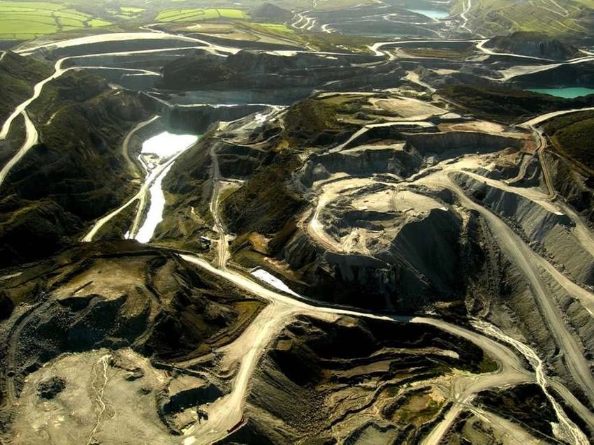
clay district to the north of the town adds 1.2.3 This topography makes an important slopes affording views of tiered roof-
a further dramatic backdrop with its spoil contribution to the character and inter- scapes, which give way to views and
heaps dominating the skyline. est of the historic town centre, with the glimpses of the surrounding countryside.
town’s streets laid out on the valley
5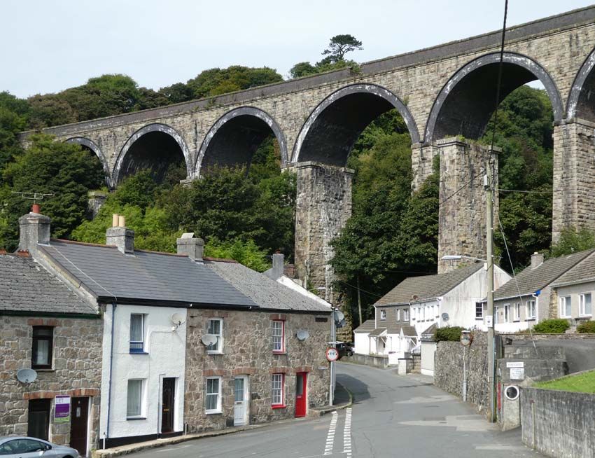
St Austell Conservation Area Appraisal                                                                                  1: Introduction

1.2.4   The richness of St Austell’s underlying ge-                                                a very strong focal point for the settle-
        ology sustained a tradition of mining and                                                  ment.
        its associated industrial activities over
        many centuries. Tin, copper, iron and                                              1.2.6   St Austell is a town that has evolved with
        china clay made the town into a prosper-                                                   a rich diversity of architecture, reflecting
        ous industrial and administrative centre.                                                  the local materials of the area, particu-
        The nearby river valleys [with its easily                                                  larly granite, Pentewan stone and slate,
        available supply of running water to                                                       in their construction but also displaying
        power mills, tin streaming and blowing                                                     new materials such as other decorative
        houses for tin smelting] have been a fo-                                                   stones, brick and terracotta that were
        cus for industrial usage since at least me-                                                imported after the opening of the railway
        dieval times. The Hensbarrow Downs                                                         line.
        area was one of the four historic Stan-
                                                                                           1.2.7   Holy Trinity Church and the Market
        nary areas of Cornwall and was known as
                                                                                                   House, which became the administrative
        Blackmore. There is evidence that a
                                                                                                   and economic centre, are the two most
        Stannary Court operated from St Austell.
                                                                                                   significant historic buildings. They are lo-
1.2.5   St Austell has a rich historic and cultural                                                cated at the heart of the town where the
        heritage. In 1259 Bishop Bronescombe                                                       original medieval radial street pattern fo-
        travelled through the West Country                                                         cusing on the church can still be seen to-
                                                      View of Fore Street taken from the           day.
        blessing and dedicating many historic            Holy Trinity Church tower
        churches. His visit to Holy Trinity Church
                                                                                           1.2.8   The oldest buildings and narrow streets
        helped to establish the importance of St      Image courtesy of Heritage Lottery
                                                        Fund. Photo © Chris Saville                are clustered around this centre which is
        Austell. The iconic Holy Trinity Church
                                                                                                   primarily accessed by Fore Street – the
        with its richly carved Pentewan stone
                                                                                                   main link between Truro and the sur-
        tower is one of the finest in Cornwall and

                                                                                                                                     6
St Austell Conservation Area Appraisal                                                           1: Introduction

         rounding countryside. This route was im-    Trenance Viaduct. The line was con-
         portant to bring goods into the town and    structed by the Cornwall Railway Com-
         its central market place. Consequently,     pany in 1859. The piers that held the
         Fore Street grew as the primary retail      wooden supports of the original viaduct
         area in the 19th century as the town’s      design by Brunel still remain alongside its
         wealth and commercial activity in-          1898 stone replacement.
         creased. The conservation area includes
         the historic “old bridge” on the original
         crossing of the St Austell River. The
         bridge and riverside walks are an im-
         portant feature of the Conservation
         Area.

1.2.9    Surrounding the medieval core there is a
         ring of early 19th century development
         with the main roads running through it.
         This contains many of the non-conform-
         ist chapels which were developed at this
         time and several civic structures.

1.2.10   Beyond this there is another ring of late
         19th century development containing the
         railway and the large villas and terraces
         of residential growth

1.2.11   On the northern edge, the Conservation
         Area extends out to the dramatic

                                                                                                            7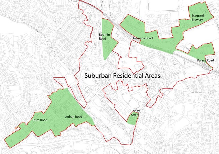
St Austell Conservation Area Appraisal                                                                                         2: Historical Development

2 HISTORICAL DEVELOPMENT                                       Gover Valley. Later urban growth has           2.3     Landscape setting
                                                               also taken place along the B3874 in a
                                                               north and east direction in the districts of   2.3.1   St Austell’s surrounding landscape set-
2.1     Location and setting                                   Mount Charles, Carclaze, Boscoppa and                  tings are a significant asset for the town.
                                                               Bethel.                                                Its surround of steep-sided wooded val-
2.1.1   The old heart of St Austell is situated at
                                                                                                                      leys, the gently undulating plateau of the
        the head of a dry coombe on the slope of
        a south-facing hillside located immedi-
                                                       2.2     Geology                                                killas to the south, and the wilder dis-
                                                                                                                      turbed china clay district of Hensbarrow
        ately east of the confluence point of two      2.2.1   The landscape of Cornwall is marked by a               to the north strongly influence St Aus-
        steep-sided river valleys, the Gover                   spinal structure of granite outcrops run-              tell’s growth and the character and ap-
        Stream and the St Austell or Vinnick                   ning along its length. Bodmin Moor, St                 pearance of the town itself.
        River, which collectively is termed the                Austell (or Hensbarrow), Carnmenellis,
        ‘White River’ catchment. These run                     Land’s End and the Isles of Scilly.            2.3.2   The surrounding landscape can be seen
        south out from the granite upland of the                                                                      as a backdrop to closer views of the Con-
        china clay district of Hensbarrow Downs.       2.2.2   The granite contains seams of deposited                servation Area and are completed by the
        The rivers merge at the Gover Road–                    minerals that have been so important in                maturing treescapes in private gardens
        Trelake Road junction in St Austell’s in-              shaping St Austell’s history notably tin,              and public spaces in the town itself.
        dustrial valley and run due south in a less            copper, iron and uranium. Hensbarrow
        deeply cut valley to exit into the sea at              is the most complex of the granite             2.3.3   The Cornwall and Isles of Scilly Landscape
        Pentewan. Two miles south east the St                  masses in Cornwall and from it has been                Study Character Assessment 2005-2007
        Austell area is framed by the South Corn-              quarried a wide variety of granite-based               identifies the characteristics in more de-
        wall coastline, with the historical ports of           stone types and kaolin or china clay.                  tail and can be seen here:
        Charlestown and Pentewan.                                                                                     http://map.cornwall.gov.uk/re-
                                                       2.2.3   St Austell itself lies in the Cornish killas           ports_landscape_chr/areaCA39.pdf
2.1.2   To the south the A390 works both as a                  landscape (‘killas’ being a mining term re-
        boundary and conduit for later urban                   ferring to local metasedimentary rocks).       2.3.4   The farmland surrounding St Austell in
        growth, which unfolds west along the                                                                          the “killas” landscape - which can be

                                                                                                                                                       8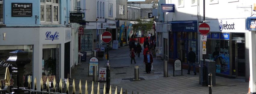
St Austell Conservation Area Appraisal                                                                            2: Historical Development

        viewed particularly to the south and east             wider modern township but is not visible
        from the old core of the town is prevail-             from within the old core of St Austell.       Daphne du Maurier writing in
        ingly medieval in origin. Networks of                                                                 1967 gives the following
        winding lanes, and roads connect farm-        2.3.7   The china clay extraction in the upland               description:
        ing settlements whose layouts are typi-               landscape of Hensbarrow Downs has re-
                                                              sulted in a highly-disturbed landscape        “The interest to the casual wanderer
        cally irregular, with small fields divided
                                                              possessing a certain lunar quality, con-         in the china clay country, is the
        by hedges topped with hawthorn, holly,
                                                              sisting of flat-topped and older conical        strange, almost fantastic beauty of
        hazel, ash and oak. There are frequent                                                               the landscape, where spoil heaps of
        small steep broadleaved wooded valleys                waste heaps intermingled with pools of
                                                                                                             waste matter shaped like pyramids
        giving it an intimate feel.                           sometimes turquoise or green water-               point to the sky, great quarries
                                                              filled tips.                                  formed about their base descending
2.3.5   To the north of the town is found a                                                                 into pits filled with water, icy green
        heather moorland landscape with a             2.3.8   Today many of the conical heaps have          like arctic pools. The pyramids are
        greater range and irregularity of field               been re-shaped into flat-topped spoil         generally the highest, and the pools
                                                              heaps and hydroseeded. Overlaying this        deepest, on land which is no longer
        patterns. The straighter sided fields indi-
                                                              landscape is the ephemera of the extrac-        used; the spoil heaps sprout grass-
        cating post 17th century enclosures.
                                                              tion industry – pipelines, gantries, rail-    seed, even gorse, upon the pumice-
                                                                                                                stone quality of their surface.”
2.3.6   This killas landscape of sequestered val-             ways, pylons, electricity lines, processing
        leys creates a striking backdrop from                 and other industrial buildings.
        many of the vantage points within the
        older part of the town. Their verticality
        is further emphasised by the elevated
        position of valley-side residences and
        their mature treeline, and the piers and
        arches of the railway viaducts. The sea is
        present as a distant backdrop to the

                                                                                                                                           9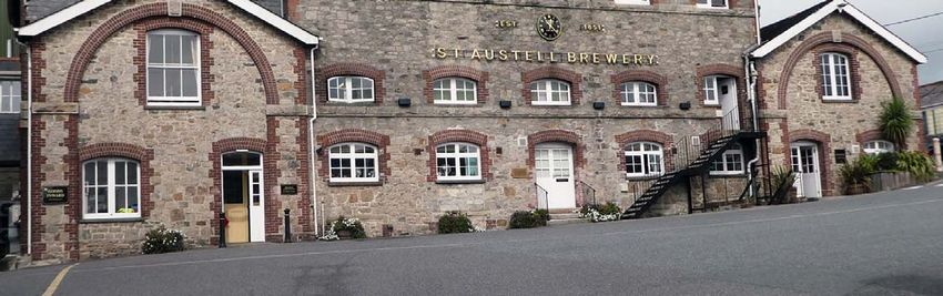
St Austell Conservation Area Appraisal                              2: Historical Development

                                            Hensbarrow Pits.

                                         Source: Historic England

                                                                                      10
St Austell Conservation Area Appraisal 2: Historical Development
2.4 Early origins and 2.5 Medieval market town in shape and size of strips, but the typical
burgage plots of a planned medieval
archaeology 2.5.1 Prior to its industrial development, St town are not so evident in this street pat-
Austell was a small agricultural town con- tern.
2.4.1 Documentation records the siting of an
sisting of a clustering of streets around
Iron Age – Romano British (800BC-
the church, forming a natural meeting
409AD) suggested round sited in the cen-
place for the parish. The churchyard is
tre of St Austell and the discovery of an
small and rounded, suggesting its possi-
Iron Age spearhead. Early settlement in
ble origins as a lann (an enclosure defin-
the wider St Austell district is evidenced
ing a consecrated area), its shape and po-
with finds of Bronze Age axes and spear-
sition at the head of a valley, being typi-
heads and Iron Age artefacts, which have
cal for an early medieval church. The
been found in the Pentewan Valley.
street pattern is typical of many Cornish
2.4.2 There is evidence of early medieval set- settlements, with the church located on
tlements in the surrounding area such as its elevated circular mound, acting as a
the discovery of the silverware hoard at meeting place with the streets radiating
Trewhiddle in 1774. out from that focal point.
2.4.3 Menacuddle Well, which is located just 2.5.2 This “churchtown” was likely to be the
north of the Trenance viaduct on the main extent of early medieval St Austell.
Bodmin Road, is documented in 1291 as The expansion along Fore Street is likely
a baptistry chapel, and its use ceased in to be late medieval growth in the 16th
c1537 with the dissolution of the monas- century facilitated by mining activity
teries. around Polgooth.
2.5.3 There are a range of narrow plots radiat-
ing out from the core, and wide variation
11St Austell Conservation Area Appraisal 2: Historical Development
2.5.4 The tradition of using the old core district later Mummers’ plays were enacted. The
as a meeting point was continued in me- place name may be then an embodiment
dieval times by the marking of the conflu- of a long habitual usage of a play. In 1661
ence of three old manorial boundaries – the market received its charter with tolls
Trewington, Trenance and Treverbyn by from the Friday market and annual fairs
means of the Mengu Stone (probably a being granted in trust to the poor of the
boundary marker established by an early parish. The 1842 Tithe Map shows what
Medieval charter). Here town proclama- is now the north end of Cemetery Park
tions were read, cattle impounded and was the field for the annual fair.
public punishments carried out. It was
originally located in front of the Old 2.7 The industrial town
Manor House, which would have faced
2.7.1 As with many other market towns in Eng-
the west end of the church across an
land from 1750 to the end of the 19th
open market area. However, it was
Century, St Austell began to expand to al-
moved in 1972 and located to the east
Holy Trinity Church low for greater housing, commercial and
side of the tower of Holy Trinity Church.
industrial uses. The townscape of the old
Some of the earliest elements of the
centre of St Austell is a cameo typical of
church building have survived includ- 2.6 Fairs, festivities and
ing the remains of a 13th century those changes that took place across
chantry chapel in the south side of the markets many of the market towns in England
chancel and Lady Chapel. The church during that time. St Austell’s industrial,
2.6.1 Between the churchyard and what is now
has a particularly fine ornately carved commercial and social life became more
15th century tower, with its sculptured the ‘Red Bank’ was another meeting
active in the latter half of the 18th Cen-
figures depicting the twelve apostles, point, the Bull Ring. It is not certain
tury and accelerated in the 19th Century
as well as shields, animals and gar- whether bulls were actually baited there,
as the Victorian enthusiasm for civic re-
goyles all carved in the honey-coloured but it may have been a medieval ‘playing
Pentewan stone and granite. modelling combined with an increasing
place’ where traditional miracle plays or
prosperity took hold. The river valley
12St Austell Conservation Area Appraisal 2: Historical Development
with access to power became the focus and cheap lodgings for labourers em-
of early industrialisation and has several ployed in workshops like the hat factory.
important sites including a Corn Mill, A century later the more prosperous
Foundry with water wheel and a sawmill. tradesmen who had lived over their
shops moved out, and the central streets
Trades and industries of the town were given over to more ex-
clusively public and commercial uses,
2.7.2 Before the Industrial Revolution the base with town houses being converted into
for most trades and industries in the offices for solicitors and banks, all adding
town was derived from its surrounding to the outward spread of the town. For
countryside such as grinding grain and example, the 1842 Tithe Map of St Aus-
making tools for the surrounding farm tell shows stalls clustered around the
population. The town became the indus- south edge of the churchyard, which
trial centre because its communications were part of the market place before the
were better than the surrounding vil- Market House was built. The 1881 Ord-
lages, and at the same time the limited nance Survey map (published in 1889 see
communications made the town self-suf- appendix) shows them to have disap- Extract from 1842 Tithe Map show-
ficient in its material requirements. The peared replaced by the Market House ing seven streets converging on the
1842 Tithe map shows a courtyard hat and Town Hall, and a proliferation of historic core and the churchyard.
‘factory’ just behind Church Street and a banks and a post office clustered around Church Street, Market Street, High
rope walk just outside the centre of town Cross Street, Trevarthian Road, Mar-
the church.
on Menacuddle Hill. ket Hill, North Street, and Fore
Street that formed the pattern all re-
2.7.3 In the mid-18th century streets close to main today.
the town centre would have been occu-
pied by shopkeepers, cobblers, grocers
13St Austell Conservation Area Appraisal 2: Historical Development
wine merchant and brewer, Walter in 1761, and notably a milestone on the
Hicks, joined in with St Austell’s industrial south end of Truro Road sited in c1764.
development by building a steam pow- The mining and clay industries were an
ered brewery in 1869 in the centre of St added impetus to road improvements in
Austell, in what is now Tregonissey St Austell, the New Bridge on the Truro
House. Within 25 years the business had Road being an example of such road im-
outgrown the building and in 1893 he re- provements constructed in 1834 as a sin-
located to the larger site above the town gle span granite ashlar structure. Later,
in Trevarthian Road, the present-day St railway competition abruptly finished off
Trenance Mill – an early 19th century Austell Brewery. coach travel and the turnpike trusts.
corn mill on Blowing House lane. It is
one of several industrial sites in the river
Road and rail transport Tramway and Harbour
valley
2.7.5 Prior to the advent of the car roads were 2.7.7 Driven by the developments in Pentewan
th
2.7.4 The 19 century process of mechanisa- mainly the responsibilities of the local Harbour, St Austell saw the construction
tion changed the small-scale workshop parish. Due to expanding commercial ac- of another kind of transport system. Be-
into factory-scale production, so busi- tivity the 18th century saw an increase in tween 1818 and 1826 Pentewan’s land-
nesses grew in size. The railway also rad- coach travel and the development of lord Christopher Hawkins had built a new
ically improved communications so that turnpike trusts, which created better harbour, a speculative venture based on
the ‘import and export’ of goods com- road surfacing and route improvements. the expanding china clay industry and the
pletely changed. An example of these Tollhouses, milestones, coaching inns potential of the pilchard fishery. To con-
changes was the Walter Hicks Brewery. and wayside pubs are the most visible nect the Pentewan Harbour with St Aus-
Breweries were originally domestic and survivals of this period. tell he also built a horse-drawn tramway
small-scale business, but with the intro- completed in 1830.
duction of steam power larger-scale 2.7.6 In St Austell, a number of granite mile-
commercial breweries developed in stones were erected by the St Austell and 2.7.8 Despite the investment, the tramway
many larger villages and towns. Local Lostwithiel Trust, which was established and harbour only saw limited success,
14St Austell Conservation Area Appraisal 2: Historical Development
acting mainly as an overflow port to the Hensbarrow uplands by wagon to be
Charlestown, Par and Fowey. However, transferred to the railway trucks for the
it began to be used for another im- journey down to the harbour.
portant trade – limestone, which was
used to supply local kilns, and by 1832 it
eventually overtook the tonnage of china
clay. Coal was also imported on the
tramway to supply St Austell gasworks as
well as timber, salt, tallow and grain for
local needs.
2.7.9 In 1868 the horse-drawn line was con-
verted to steam traction along with other
major works carried out to improve the
harbour, but by the late 19th century
competition from the clay ports of Par
and Fowey began to eclipse Pentewan’s
trade. By the end of World War I most of
Pentewan’s traditional export/import
trades had ceased. In 1918-1919 the rail-
way lines and engines were requisitioned
by the War Office and the railway line
lifted. Today the only remnant of this rail
linkage is the Clay Cellars standing in
West Hill car park. This was once part of
an extensive 200 feet long railway termi-
nus. Here clay was brought down from
15St Austell Conservation Area Appraisal 2: Historical Development
Railway
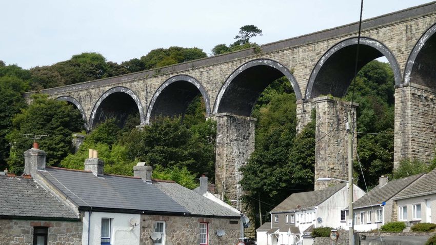
2.7.10 In 1859, with the construction of Brunel’s
Royal Albert Bridge over the River Tamar
at Saltash, the railway age came to St
Austell. In building the Cornish section
following the design pioneered by Brunel
the railway company was confronted by
a significant civil engineering problem
presented by the frequent deep and nar-
row valleys cut by the rivers running out
of the granite moors such as Bodmin
Moor and Hensbarrow. Due to the cost
the timber viaduct construction was a
way around these issues, using two
standard spans to enable a standardised
trestle system of timber sections to span
the viaduct piers. The frequent use of
this construction method made them a
familiar and sometimes dramatic feature
of the Cornish landscape. The old granite
piers of Trenance viaduct are a fine ves-
tige of one of Brunel’s designs for timber
viaducts.
Trenance viaduct
2.7.11 In 1898 the old Trenance viaduct was re- The original piers from the 1859 Brunel design viaduct still remain in front of the 1898 replacement.
placed with the existing structure. In
16St Austell Conservation Area Appraisal 2: Historical Development
1892, Great Western Railway had con- goods yard, a signal box and station away such as Ashburton Limestone and
verted from its broad gauge to the na- buildings. Portland Stone.
tionally adopted standard gauge so the
new viaduct allowed for the line to be 2.7.15 Other buildings constructed at this time
Civic and commercial buildings included the Workhouse, 1839 (now de-
twin-tracked.
2.7.13 Extensive civic building took place as 19th molished), Assembly Rooms, 1846, the
2.7.12 Today the railway has left St Austell a rich century St Austell’s industrial, commer- Corn Exchange, 1859 (demolished 1960),
heritage of surviving structures – cut- cial and social life accelerated, combined the police station, 1866 (demolished
tings, embankments, viaducts, bridges, a with the town’s increase in prosperity.
These changes were carried out by a
combination of private companies, spec-
ulators, philanthropic bodies and the lo-
cal authority, which became more organ-
ised through this period.
2.7.14 Civic buildings displayed the town’s new
confidence with new architectural styles
drawn from the classical styles of the Re-
naissance. An example is the Italian Re-
naissance style of the Market House and
Red Bank, High Cross Street
Postcard showing the original Brunel viaduct Town Hall built in 1844 - “a great orna-
with its timber trestles supporting the broad- ment to the town”. The new commercial Silvanus Trevail’s Red Bank, 1898, in
gauge track. The trestles were cheaper to buildings, particularly the banks, showed High Cross Street is an example of a
build and designed so timbers could be re- a variety of architectural ornament in fine civic building constructed with
placed, but in the long term were much more new materials transported quickly and
neo-classical styles, with facades con-
expensive to maintain cheaply by the new rail line. The
structed from locally quarried granite,
bricks here were imported from Rua-
Source: Geoffrey Sheppard Collection and stone types brought in from further
bon in North Wales.
17St Austell Conservation Area Appraisal 2: Historical Development
2007) and the former Liberal Club, 1890. to the outskirts of the town (map No.7).
Some buildings required wholly new Increasingly different types of dwelling
types of construction such as the railway became differentiated, with the profes-
station (remodelled in 1898), as well as sional classes and the better off trades-
the workhouse, schools and gasworks. men moving into more comfortable town
These were provided for by the availabil- houses and villas, with terraces of cot-
ity of new materials such as iron, steel tages being apportioned for the labour-
and concrete - cheaper products which ing population. This process of class divi-
could be assembled more quickly, and sion is clearly visible in the townscape of
importantly moved around in bulk from St Austell. The workers’ cottages at the
other parts of the country by rail. junction of Grove Road and Trennance
Road and, in the vicinity of Ledrah Road
Housing and Pondhu Road, are typical examples
located near the foundries and other in-
2.7.16 During the 18th century it became fash- dustrial works
ionable for wealthier families to build Silvanus Trevail, the flamboyant
town houses, reflected, for example, in Victorian architect, also designed 2.7.18 Designed by Silvanus Trevail, the rows of
smaller domestic buildings such as the cottages in Moorland Road stand out as
the construction of the Rashleigh’s town
group of terraces along Moorland
house in Church Street. In 1735 it was re- an important example of his philan-
Road. These are simply modelled, of
worked into a hotel, the White Hart, to thropic intention to improve housing
good proportions and using the best
accommodate the increase in coaching conditions for working people.
materials such as Pentewan Stone, red
traffic. This change was consolidated by brick for arched window surrounds,
the bringing in of the new south road 2.7.19 In mid-Victorian times the villa became a
Delabole slate roofs and softwood
from Devonport to Truro in 1760. hallmark of middle class aspiration. Its
sliding sash windows. The progress of
design moved away from the typical
development along the road can be
2.7.17 As the town grew in the 19th century working class terraced cottage. This
seen from the date stones.
more spacious housing was being added
18St Austell Conservation Area Appraisal 2: Historical Development
sense of ‘property’ was further empha- their day - to take a journey on the rail-
sised by the construction of high stone way was to travel up the social scale.
boundary walls, gated entrances and
landscaped gardens. Places of worship
2.7.20 A pleasing garden became a popular as- 2.7.22 The many nonconformist chapels in St
piration with greater access to new Austell make an important contribution
plants and improvements in the study, to its townscape. One of the earliest is
display and cultivation techniques during the Society of Friends (Quaker’s) Meeting
the Victorian period. This made garden- House built in 1829. Others include the
ing more accessible to a wider section of Zion Chapel, St John’s Methodist church
the population and was significant in the and the Baptist chapel. The Methodist
development of suburban gardens add- denomination with its various offshoots
ing to the special character of the town. was one of the main driving forces be-
hind chapel construction in the area. Its The side elevation of the Bible
2.7.21 The urban pattern of villas in St Austell appeal, particularly to the mining com- Christian Chapel in Trevarthian Road
highlights these underlying social aspira- munities, was that it spoke to the people also known as the Zion Chapel. It was
tions. The villas on the north side of Bod- in a language that they could understand built in 1891 and is still unused since
min Road are built in a prime location declaring a simple doctrine of justifica- being closed in 1994.
with commanding views over the Gover tion through faith. The nonconformist
Valley and beyond filtered by their sur- chapels became a hub of these industrial Population
round of ornamental trees and shrubs. communities bringing people together
The villas in Palace Road cluster around 2.7.23 Parish population figures through time
through social events such as chapel pic-
the railway station, the means of travel- show the transition of St Austell from a
nics and hymn singing as well as the ser-
ling for business trips, and holidays, close small market town to an industrial and
vices.
at hand. They were the nouveau riche of later commercial centre. In 1801 the
19St Austell Conservation Area Appraisal 2: Historical Development
town was a mainly agricultural commu- opment saw the growth of housing es- Mining
nity with a population of 3788. With the tates on the east side of the town, which
steady growth of tin mining the popula- absorbed several industrial hamlets, so 2.8.2 The course of the St Austell river valley
tion in 1821 was 6175, and with the min- the population increased in 1931 to historically formed the main route
ing industry accelerating with discovery 20,464. Today the population of the St through the Hensbarrow uplands, and
of copper reserves the population in Austell area is approximately 30,800 the siting of the town at the mouth of this
1831 rose to 8758. (2010 figure). ‘pass’ made it a conduit for the local ex-
traction industry. Early tin mining was
2.7.24 Through the 19th century the population 2.8 Mining, Quarrying and small and shallow in scale confined to
continued to grow. It faltered in 1871 to washing stream deposits or digging
11,793 due to an economic depression China Clay trenches on the surface of mineral-bear-
caused by the decline of the mining in- ing lodes. In medieval times tin was
2.8.1 The St Austell district has been from early
dustry and an agricultural recession, but mainly used to produce pewter and less
times a focus of mining, quarrying and
with the economic recovery driven by importantly the production of bronze
later china clay extraction. These earlier
the boom in china clay production and and decorative ware. Technological ad-
phases of mining and quarrying were
growth of supporting service industries, vances in the late 17th century and early
mainly concerned with supplying local
such as solicitors and banks, the popula- 18th century saw the development of
needs, but the discovery and exploitation
tion rose to 11,998 in 1901. deeper pit mining, so that large-scale
of china clay coinciding with the inven-
deep mining was firmly established by
2.7.25 After the disruption of World War I the tion and demands of 19th century indus-
the mid-18th century, and further devel-
trial technology, propelled the reputa-
china clay industry declined and it went oped by the progressing industrial tech-
through a long period of reconstruction tion of St Austell’s extraction industries
nologies of the 19th century.
that was only completed in the 1930s, to national and international levels of im-
portance. 2.8.3 The downward pursuit of tin through pit
the population in 1921 being 13,577.
However, Government grants issued in mining began to disclose lodes of copper
the 1930s for large-scale housing devel- causing a shift away from tin, and creat-
ing a pivotal change in the economic
20St Austell Conservation Area Appraisal 2: Historical Development
structure of the mining industry. Copper Austell are recorded as far back as 1689. Eddystone lighthouse. Large local moor-
mining reached its height in the 1820s However, by the 19th century most Cor- stones, (large stones lying freely on the
and 1830s with tin mining continuing nish copper ore was transported to the surface of the moorland) were used for
alongside, particularly with the success neighbouring South Wales coalfield for the imposing Treffry Viaduct built be-
of Wheal Eliza. However, in the 1860s smelting. Nevertheless, local foundries tween 1839 and 1842 by local industrial-
there was a worldwide collapse in the were kept busy producing equipment for ist Joseph Thomas Treffry. The viaduct
price of tin and the competition of larger the mines such as shovels, kibbles and was the first large viaduct to be built in
reserves of copper being exploited chains, and some diversified to make en- Cornwall and it was used for transporting
abroad began to draw copper mining to gines and boilers. Following the arrival of horse drawn wagons and water across
a close in the 1880s. From then on, the the railways they were able to provide the Luxulyan Valley.
extraction industry moved over to china civil engineering components. The China
clay. Clay industry kept many foundries in pro- 2.8.7 Carn Grey granite is the main building
duction until the 1930s. stone used in the older buildings in St
2.8.4 Iron ore was also mined in these areas, Austell, for example in the Market
usually in shallower lodes than tin. The House, built in 1844. Local granites were
zenith of this industry being around 1860
Quarrying also used for building from the St Ste-
with the Restormel mine closing in 1912. 2.8.6 The main quarrying area was around the phens district on the west side of the St
east side of the St Austell granite in Lux- Austell Granite area. This stone is often
2.8.5 The mining industry generated an exten- ulyan and Lanlivery, the only areas free referred to as ‘St Stephen’s stone’, and is
sive range of support industries, particu- of kaolinisation. Locally quarried gran- the palest coloured granite in Cornwall,
larly foundries. The Gover Stream valley ites can be seen in the buildings through- some variants being almost white in col-
had been a focus for industrial uses since out the town of St Austell and in the sur- our.
at least the medieval period, using flow- rounding towns and villages, such as
ing water as a power source for mills and Charlestown and Luxulyan. Granite from
blowing houses. Blowing houses were this area was also used locally for the
buildings for smelting tin with a furnace construction of Par Harbour and for the
and bellows powered by the water. in St
21St Austell Conservation Area Appraisal 2: Historical Development
Austell is the 15th century church tower with it an increasing demand for porce-
of Holy Trinity Church with its carvings of lain. This material produced finer pot-
the twelve apostles along with shields, tery than the local artisan clay products
gargoyles and other grotesques. The So-
ciety of Friends meeting house at the top 2.8.11 Kaolin, or China clay, is one of the key
of High Cross Street is also built out of the constituents of porcelain. It is produced
stone, its restrained and simple form by the decomposition of materials such
showing off the soft pastel colours of the as feldspar in the granite. Some of the
stone to great effect. finest deposits in the world were discov-
ered in the St Austell area. A Quaker
2.8.9 The local Devonian slate was generally apothecary from Plymouth, William
The warm colour of Pentewan stone
on the Quaker Meeting House con- avoided for external work in building Cookworthy recognised the deposits in
trasts with the Carn Grey granite on construction due to its tendency to dete- Cornwall in 1746. He experimented with
the retaining wall to the station. riorate and spall. However, in the form various samples and in 1768 he took out
of local freestone, it has been used in a patent to use the material, soon pro-
2.8.8 Pentewan stone, a felsitic Elvan rock boundary wall and worker’s cottage con- ducing items at his Plymouth Porcelain
more fine-grained than granite, is one of struction within the town Factory. In 1775 Josiah Wedgwood came
Cornwall’s finest building stones. Most to St Austell to lease china clay deposits.
of it was quarried out of a dyke intrusion China Clay 2.8.12 By the early 19th century the kaolin in-
in a valley just behind Pentewan village.
2.8.10 Porcelain had come from China as early dustry had become highly successful as
It has superior durability compared to
as Tudor times but was such a rarity that the demand grew from an increasing
the Jurassic limestone of the Cotswolds
only royalty and the aristocracy could af- number of properties making use of
but can easily be carved into ornamental
ford it. The growth in popularity of the porcelain. Many of the potters owned
stonework. With its straw yellow to pale
tea trade in the mid-17th century brought rights to mine the material for their own
rose pink hues it makes a unique visual
companies. By the middle of the 19th
impact within the built environment of
the town. Its most conspicuous use in St
22St Austell Conservation Area Appraisal 2: Historical Development
century, china clay was increasingly be-
ing used as a raw material for the produc-
tion of paper, in calicoes and cottons,
whitewash and plaster, and pharmaceu-
ticals. Today the china clay production is
less in scale but is used in a wide range of
industries: paper, paint products, cables,
natural and synthetic rubbers, the build-
ing industry in concrete, mortar and glass
fibre, and in agriculture in granular ferti-
lisers.
2.8.13 Prior to the coming of the railways St
Austell was ideally situated to trade and
transport this material. The wagons of
china clay could be driven down the val-
leys from Hensbarrow through the town
to the small ports of Pentewan,
Charlestown and Par.
2.8.14 In the early days of china clay production Carting the china clay in wagons along Fore Street.
Charlestown was the main outlet and at
the same time imported coal and timber Source: Wheal Martyn Museum
for the industry although Par later be-
2.8.15 With the coming of the railway in 1859, deep-water harbour having the capacity
came more important as the main outlet
Fowey became the leading port with its to receive big ocean-going ships.
for transportation by sea.
23St Austell Conservation Area Appraisal 1:
2.8.16 The China Clay industry flourished up to 2.9.3 In the town centre, there was a signifi-
its zenith in the 1930s with the formation cant period of redevelopment during the
of the English China Clays company in 1960s with the demolition of historic fab-
1932. ric and the building of Aylmer Square,
Cornwall’s first purpose-built shopping
2.9 20th century housing precinct including a new supermarket
and multi-storey car park.
expansion and retail
redevelopment 2.9.4 These buildings have now been mostly
redeveloped with the first phase of
2.9.1 After the first world war the town began White River Place which brought a wider
a plan of further expansion to the south range of shop units, additional parking,
with the development of a new road and open streets and new housing back into
by-pass in 1926, the A390. This opened the town centre.
up additional housing areas and marks
the southern extent of the conservation 2.9.5 New streets in this period included Trin-
area. ity Street linking two of the radial routes,
and reshaping part of South Street as a
2.9.2 Post second world war new housing con- route to divert traffic away from the his-
tinued in the next building boom with toric core.
huge growth of the town to the south
east and east. In the 1960s this included The developments above are generally
Cornwall’s first tower block, Park House, excluded from the conservation area but
next to Truro Road Park in the conserva- mark its boundaries.
tion area.
24St Austell Conservation Area Appraisal 3: Character Areas
3 CHARACTER AREAS
3.1 Introduction
3.1.1 The influences on the development of
the Town have been described in the pre-
vious section. Certain patterns or char-
acteristics are more dominant in specific
areas. The Cornwall and Scilly Urban Sur-
vey has identified these character areas
as follows:
• 1 – The Central Church Core
• 2 – Fore Street Area
• 3 – Western Gateway
• 4 – Industrial River Valley
• 5- 18th and 19th Century urban expan-
sion
• 6 – Suburban residential areas.
These areas are shown on a single plan
in Appendix 4.
3.1.2 An understanding of the key characteris-
tics of these areas will assist in evaluating
the impact of new development pro- Taken from the Church Tower – this view shows the surrounding commercial buildings and demon-
posals and enhancement projects. strates how distinctive the Red Bank building is by using very untypical materials of brick and terracotta
Image courtesy of Heritage Lottery Fund. Photo © Chris Saville
25St Austell Conservation Area Appraisal 3: Character Areas
great effect much simplifying and calm-
Character Area 1 – The Central ing the area while retaining the sense of Central Church Core:
Church Core history and quality. dominant characteristics
3.1.3 This is the oldest area of St Austell with 3.1.5 The Holy Trinity Church was mainly con- Strong sense of enclosure with con-
several routes that meet at the Holy Trin- structed in 15th century incorporating tinuous buildings of 3-4 storeys sur-
rounding the Church.
ity Church. This medieval layout con- one of the finest towers in Pentewan
verging on the central space or “Lann” stone. There are fine carvings on the Medieval street pattern very clear
can still be seen along with the narrow tower’s walls including the 12 apostles with streets radiating out from
lanes that run between the streets. The and the Holy Trinity. The church is sur- church
townscape is very dense here with hardly rounded by its raised churchyard re-
Primarily civic and commercial build-
a gap between the 3 and 4 storey build- tained by a stone wall to the south and ings surrounding church
ings. an iron railing on the perimeter. The
Mengu (meaning boundary) Stone now Diversity of architectural styles but
3.1.4 The paving and streetscape has recently in the church-yard is an important piece high quality of natural materials and
been repaved with natural materials to richness of detailing
of historic fabric. This probably dates
from the early Medieval period and Central green oasis formed by raised
marked the boundary of three local ma- churchyard
norial demesnes.
3.1.6 The Market House is a remarkable build- the priority project to restore and de-
ing, not just for its Renaissance style fa- velop for sustainable new uses. It was
çade and grand arcade but because of built in 1844 and designed by Architect
the incredible timber roof construction Christopher Eales who also designed the
within its splendid market hall. The Market and Council offices [currently Hall
building will have a major part to play in for Cornwall] in Truro.
the future life of the town and should be
26St Austell Conservation Area Appraisal 3: Character Areas
3.1.7 The commercial buildings in this core are and later converted into an inn. It is con- Seven Stars Inn on East Hill has been al-
quite varied in architectural style and use structed of simple granite ashlar at the tered externally but is still over 200 years
of materials but are handled confidently back of pavement and retains small old.
and show a great richness and quality in paned sash windows and doorcase. The
their detailing. Key examples are Silva-
nus Trevail’s Red Bank with its red brick-
work and terracotta detailing, and the
former Devon and Cornwall Bank with its
Pentewan stone rusticated ashlar façade
and vermiculated detail.
3.1.8 Vicarage Hill and Victoria Place on the
edge of this area have a wealth of archi-
tectural character with some residual
19th century shopfronts, historic sash
windows and traditional façade details
with overhanging eaves and slate roofs.
3.1.9 The Manor House is located on the nar-
row lane of North Street and this listed
building is the oldest house surviving in
St Austell, originally built in the late 17th
century. It still retains its steep slate
roof, string course and modillions.
3.1.10 The White Hart Hotel was originally built
as a town house in the early 18th century Holy trinity Church (listed grade I) and Market House (grade II*) the two most important
historic buildings in the town centre.
27St Austell Conservation Area Appraisal 3: Character Areas
3.1.11 Virtually all of the buildings in this char-
acter area make a very strong contribu-
tion to the historic character. Most are
listed buildings and nearly all of the re-
mainder are contenders for local listing.
28St Austell Conservation Area Appraisal 3: Character Areas
the back of the street with buildings pre-
Character Area 2 – Fore Street dominantly of 3 or 4 stories giving it a Fore Street
strong sense of enclosure. Dominant Characteristics
3.1.12 This street follows, in the main, the prin-
cipal thoroughfare of the very early road 3.1.14 There is a strong rhythm of vertically pro- Gentle curve of street and continuous
from London to Truro. At the East end, it portioned facades, with buildings of vari- sense of enclosure with strong focus on
focusses very strongly on the tower of ous styles represented including many church at eastern end.
the church and at the other end it opens from the 19th century. Traditional details
into the busy junction at the Western Majority of buildings are 3-4 storey
of timber sliding sash windows and shop- historic properties.
gateway with views to the landscape of fronts still exist with tight eaves or para-
the valley beyond. pets on the simpler older facades and Frequent passageways to north and
larger bay windows or more imposing south.
3.1.13 Fore Street was the street leading before
dentilled eaves or pediments on the later Strong vertical emphasis of windows
or into the market place. It became the
commercial buildings. and facades of narrow plots.
foremost living and later commercial
street in the historic town. It has a high 3.1.15 Fore Street has effectively been pedestri- Predominantly shopfronts at ground
density of development with narrower anised with limited access to vehicles ex- floor level on the town’s main com-
building plots filling the land right up to cept at key delivery times. This has ena- mercial street.
bled a high quality re-paving scheme to Different architectural styles and many
be constructed reflecting the history of retaining historical architectural detail
the town in its designs of lettering and at first floor level and above.
street furniture and the use of granite
Age of buildings spanning over 200
paving.
years.
3.1.16 Off Fore Street there are many passage-
Quality granite street paving, street
ways to the North and to the South. furniture and signage complementing
Some of these such as Biddicks Court, the historic character.
29St Austell Conservation Area Appraisal 3: Character Areas
Grants Walk and North Street retain a streets and where buildings project in with its banded brick and Portland stone
strong sense of historic character with front of the main street line. The two façade.
their tight enclosure, retained historic curved examples on North Street and
buildings and the more recent but sym- Church St corners are particularly notice- 3.1.21 Many historic shopfronts have been lost
pathetic paving schemes. To the south able. and replaced with poorer quality, flatter
the passageways are less successful be- and less detailed replacements which
cause they are enclosed by more recent 3.1.19 There are a wide range of architectural have detracted from the special historic
poor quality development with little ac- styles represented on this street, mostly character. However, recent restoration
tivity through windows or entrances on unified by their scale siting and the pro- of historic shopfront details has helped
the side elevations. These include Chan- portions. Earlier townhouses are recog- to bring back a historic character in some
dos Place and Aylmer Place giving access nised by their simpler design usually 3- buildings and further work through a fo-
to White River Place. The latter buildings storey rendered facades with a tight cussed Townscape Heritage scheme
have great potential for redevelopment eaves or parapet and vertically propor- would have a huge impact on the charac-
to provide a better, more active route tioned sash windows. They show inser- ter attractiveness and activity in the
into the retail development and more tions of 19th century shopfronts such as town.
floorspace through increased height and No’s 5 -7 and No’s 12A and 12B, all listed
bringing the building line forward to the buildings.
original.
3.1.20 Other buildings are clearly more decora-
3.1.17 At the eastern end, by the Queen’s Head, tive such as the later 19th century com-
the narrow road opens out behind the mercial properties. These exhibit a more
Queen’s Head and Market House out to ostentatious character with their use of
North Street Car Park via Menacuddle new materials such as decorative stone
Hill. and brick, bay and oriel windows, pro-
jecting window surrounds, projecting
3.1.18 The street has a number of interesting dentilled eaves, pilasters and gables. A
corner designs at entrances to side good example is the former liberal club
30St Austell Conservation Area Appraisal 3: Character Areas
Views of Fore Street
c.1910 above [source Old Cornwall Society]
and 2016 below
31St Austell Conservation Area Appraisal 3: Character Areas
this junction giving a vista of the
Character Area 3 – Western treescape across the valley beyond. Western Gateway:
Gateway dominant characteristics
3.1.23 This is a significantly important junction
3.1.22 This area is the confluence of the roads at the prime gateway to St Austell Town Busy open junction dominated by
through the town to and from the West. centre for vehicles and pedestrians. traffic.
The topography here is very steep espe- However, its sense of place, enclosure, Gateway to retail centre.
cially where the end of Bodmin Road attractiveness and ease of access for pe-
curves tightly to meet the end of Fore St. destrians is not as good as it should be for Historic townscape retained on north
Here a number of historic buildings re- such an important location. side, including former General Wolfe
pub plus historic chapel on West Hill
main. However, the tight historic street
and original Assembly Rooms on
pattern has been lost to the south to Truro Road
make room for a larger vehicle domi-
nated junction. The view from the west- Diversity of building ages and designs
ern end of Fore Street opens out across around junction.
Predominantly 3 storey buildings.
Currently lacking coordinated design,
good enclosure or strong sense of
place.
Poor accessibility for pedestrians es-
pecially getting to Bodmin Road
Memorable artwork by Janet Shearer
32St Austell Conservation Area Appraisal 3: Character Areas
3.1.24 There are, however, individual elements curved and stepped façade, improve- 47 Fore Street which is a very interesting
that have a very positive contribution to ments to the extension and the signage 1960s design.
local character namely the strong town- to the Assembly Rooms on Truro Road,
scape around the lower end of Bodmin and the restoration of the façade to 45 - 3.1.26 The former Globe Inn/Globe Yard is ob-
Road reflecting the topography and his- scured by an unattractive ranch style
toric development including the previous
General Wolfe Pub at No 3, the Public
Rooms on Truro Road by Silvanus Trevail,
the St Austell Baptist Church on West Hill,
the new shopfront at 11 Truro Road, the
recent repaving scheme on the main cor-
ner and the mural by artist Janet Shearer
on the side of 9 Truro Road which adds
very much to the sense of place through
its quality and the local associations of its
characters.
3.1.25 There are opportunities for significant
improvement in this area including the
design of a more pedestrian friendly
junction with more direct crossings and
better pavement of Bodmin Road, the re-
design of the small urban space at the
Bodmin Rd junction, signage and shop-
front improvements to Burton House
The Baptist Church on West Hill and the mural by Janet Shearer on 9 Truro Road are the key
which could present a more attractive
features of the wide traffic dominated junction.
33You can also read