Strategic Housing Development at Swords Road, Whitehall, Dublin 9 - HARTFIELD PLACE SHD
←
→
Page content transcription
If your browser does not render page correctly, please read the page content below
Strategic Housing
Development at Swords
Road, Whitehall, Dublin 9
Mobility Management Plan
Stage 3 Submission

Eastwise Construction Limited

Project reference: 379360
Project number: 60601744
PR379360-ACM-XX-XX-RP-CE-00-0002
February 2021
Strategic Housing Development at Swords                                                           Project reference: 379360
Road, Whitehall, Dublin 9                                                                         Project number: 60601744

Quality information
Prepared by                        Checked by                  Verified by                  Approved by

Zachary Cave                       Carolyn Rollo               Cormac O’ Brien              Cormac O’ Brien
Traffic Planner / Engineer         Associate Director          Director                     Director

Revision History
     Revision                Details           Revision date     Authorised          Name                 Position

          0                Draft Issue          26.01.2021          CO’B         Cormac O Brien           Director

                             Stage 3
                           Submission
          1                                     12.02.2021           CR           Carolyn Rollo      Associate Director
                         including Client
                            comments

Prepared by:
AECOM Ireland Limited
4th Floor
Adelphi Plaza
Georges Street Upper
Dun Laoghaire
Co. Dublin A96 T927
Ireland

T: +353 1 238 3100
aecom.com

© 2021 AECOM Ireland Limited. All Rights Reserved.
This document has been prepared by AECOM Ireland Limited (“AECOM”) for sole use of our client (the “Client”) in
accordance with generally accepted consultancy principles, the budget for fees and the terms of reference agreed
between AECOM and the Client. Any information provided by third parties and referred to herein has not been
checked or verified by AECOM, unless otherwise expressly stated in the document. No third party may rely upon
this document without the prior and express written agreement of AECOM.

Prepared for: Eastwise Construction Limited                                                                        AECOM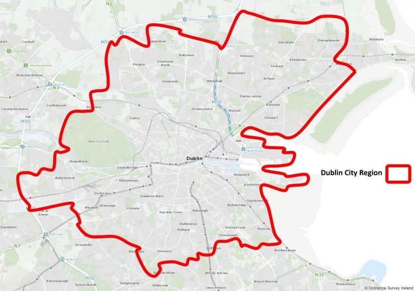
Strategic Housing Development at Swords                                                                                           Project reference: 379360
Road, Whitehall, Dublin 9                                                                                                         Project number: 60601744

Table of Contents
1.      Introduction............................................................................................................................................ 5
        1.1    Background................................................................................................................................. 5
        1.2    Proposed Development ............................................................................................................... 6
        1.3    Objective..................................................................................................................................... 7
        1.4    Structure of this Mobility Management Plan .................................................................................. 8
2.      Policy Context ........................................................................................................................................ 9
        2.1    Overview..................................................................................................................................... 9
        2.2    Dublin City Council Development Plan ......................................................................................... 9
        2.2.1 Movement and Transport (MT) Policy 2 – Overarching.................................................................. 9
        2.2.2 Movement and Transport (MT) Policy 3 – Public Transport ........................................................... 9
        2.2.3 Movement and Transport (MT) Policy 8 – Active Travel (Walking and Cycling) ............................... 9
        2.2.4 Movement and Transport (MT) Policy 13 – Mobility Management and Travel Planning................... 9
        2.2.5 Movement and Transport (MT) Policy 18 – Car Club ..................................................................... 9
        2.3    Transport Strategy for the Greater Dublin Area, 2016 – 2035 ........................................................ 9
        2.4    Project Ireland 2040 .................................................................................................................. 10
        2.5    Smarter Travel – A sustainable Transport Future ........................................................................ 10
3.      Existing Infrastructure........................................................................................................................... 12
        3.1    Overview................................................................................................................................... 12
        3.2    Existing Site Access .................................................................................................................. 12
        3.3    Local Road Network .................................................................................................................. 12
        3.4    Active Travel – Pedestrian and Cyclist Facilities ......................................................................... 13
        3.4.1 Swords Road ............................................................................................................................ 13
        3.5    Sustainable Transport – Bus Services ........................................................................................ 14
        3.6    Sustainable Transport – Heavy Rail Network .............................................................................. 14
        3.7    Sustainable Transport – Light Rail Network ................................................................................ 15
        3.8    Sustainable Transport – Car Sharing.......................................................................................... 15
        3.9    Emerging Transport Infrastructure .............................................................................................. 17
        3.9.1 Local Road Proposals ............................................................................................................... 17
        3.9.2 Cycle Network Proposals ........................................................................................................... 17
        3.9.3 Bus Network Proposals ............................................................................................................. 18
        3.9.4 Metro Link ................................................................................................................................. 19
4.      Characteristics of Proposals ................................................................................................................. 20
        4.1    General..................................................................................................................................... 20
        4.2    Proposed Development ............................................................................................................. 20
        4.3    Pedestrian and Cyclist Permeability ........................................................................................... 20
        4.4    Cycle Parking Provision ............................................................................................................. 21
        4.5    Car Parking Provision ................................................................................................................ 22
5.      Existing Travel Patterns ........................................................................................................................ 23
        5.1    Overview................................................................................................................................... 23
        5.2    National Household Travel Survey ............................................................................................. 23
        5.2.1 Dublin City ................................................................................................................................ 23
        5.3    Census Data ............................................................................................................................. 24
        5.4    Comparison of the NHTS Vs the Census 2016 ........................................................................... 26
6.      Targets ................................................................................................................................................ 27
        6.1    Swords Road Proposed Modal Trips .......................................................................................... 27
        6.2    Swords Road Proposed Targets ................................................................................................. 27
7.      Mobility Management Measures ........................................................................................................... 28
        7.1    Approach .................................................................................................................................. 28
        7.2    Mobility Management Coordinator (MMC) .................................................................................. 28
        7.3    MMP & Associated Action Plan .................................................................................................. 28
        7.3.1 Welcome Package .................................................................................................................... 28
        7.4    Mobility Management Information Point ...................................................................................... 29
        7.5    Website..................................................................................................................................... 29
        7.6    Walking ..................................................................................................................................... 29
        7.7    Public Transport – Bus Use........................................................................................................ 29
        7.8    Car Sharing............................................................................................................................... 30
8.      Monitoring............................................................................................................................................ 30

Prepared for: Eastwise Construction Limited                                                                                                            AECOM
Strategic Housing Development at Swords                                                                                   Project reference: 379360
Road, Whitehall, Dublin 9                                                                                                 Project number: 60601744

9.      Summary and Conclusion..................................................................................................................... 31
        9.1 Summary .................................................................................................................................. 31
        9.2 Overall Conclusion .................................................................................................................... 31

Prepared for: Eastwise Construction Limited                                                                                                   AECOM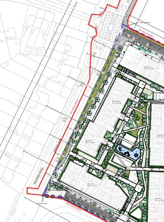
Strategic Housing Development at Swords Project reference: 379360
Road, Whitehall, Dublin 9 Project number: 60601744
1. Introduction
1.1 Background
This Mobility Management Plan (MMP) has been prepared by AECOM in support of a planning application to An
Bord Pleanála (ABP) for 475 no. residential apartments with a café, creche and residential amenity facilities on a
site located off Swords Road, Whitehall, Dublin 9.
The proposed development entails 475 no. residential apartments, comprising of the following breakdown:
• 26 no. studio apartments;
• 179 no. 1-bedroom apartments;
• 251 no. 2-bedroom apartments; and
• 19 no. 3-bedroom apartments.
In addition, the scheme includes for a crèche (414.0 sqm) and café (99.0 sqm). As part of the scheme, it is proposed
to provide 348 car parking spaces (284 at basement level and 64 at grade) and 527 cycle parking spaces (480
long stay and 47 short stay spaces). In respect of the proposed site access arrangements, AECOM have engaged
with Dublin City Council (DCC) and the National Transport Authority (NTA) to agree a junction layout arrangement
which would not impede the delivery of the future BusConnects scheme along the Swords Road, Core Bus Corridor
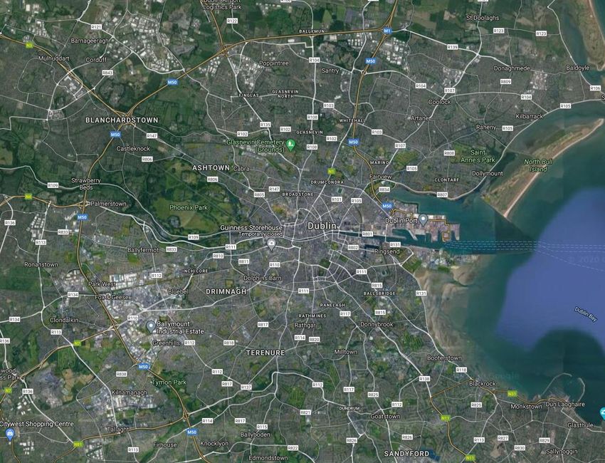
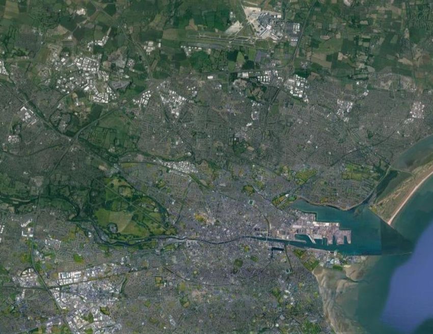
2. Swords to City Centre. The proposed Strategic Housing Development (SHD) is located approximately 3.9km
from Dublin City Centre and approximately 3.4km from the M50 Junction 3. A site location map is presented in
Figure 1.1 and Figure 1.2.
To accompany this MMP, a Traffic and Transport Assessment (TTA) has also been prepared by AECOM, which
outlines the traffic and transportation impacts associated with the development proposals. The TTA should be read
in conjunction with this MMP.
Indicative Site
Location
Figure 1.1 – Site location in Relation to the Greater Dublin Area (Source: Google Maps)
Prepared for: Eastwise Construction Limited AECOM
5
Strategic Housing Development at Swords                                                       Project reference: 379360
Road, Whitehall, Dublin 9                                                                     Project number: 60601744

                                                                               Collins Avenue
                                                                                   (R103)
                            Swords Road
                              (R132)

                Indicative Site
                  Boundary

                                                                         Site Location

Figure 1.2 – Site Location (Source: Google Maps)

1.2          Proposed Development
Eastwise Construction Limited intend to apply to An Bord Pleanála for permission for a strategic housing
development at a c. 2.73 ha (27,340 sq m) site at Swords Road, Whitehall, Dublin 9. The site is bounded to the
west by Swords Road, to the south by Highfield Hospital, to the north by vacant lands and GAA pitches and to the
east by Beechlawn Nursing Home with residential development beyond. To facilitate the proposed development
infrastructure works are also proposed to Swords Road including the installation of a 225mm diameter watermain
connecting to an existing watermain located on Collins Avenue, the installation of a foul and a surface water mains
connection to High Park in the north eastern corner of the site and a connection to the existing surface water main
on Swords Road at the south western corner of the site. The proposed development also includes works to the
adjacent road network including the introduction of a signalised fourth arm to the existing Swords Road / Iveragh
Road junction with pedestrian crossings provided to all arms of the junction, to facilitate this one car parking space
will be required to be removed along the western side of Swords Road and a new pedestrian refuge island will be
provided on the southern arm of the junction. A right turn pocket is to be provided into the subject site on the
northbound approach of Swords Road with a left turn filter lane provided on the southbound approach, shared with
the bus lane. The proposed development also includes the relocation of the existing footpath (along Swords Road)
eastwards and the provision of a grass verge at the location of the existing path and a cycle path along the western
boundary of the subject site. The proposed infrastructure works and road network upgrade works are all on an area
measuring c. 0.51 Ha, providing a total application site area of c.3.25 Ha (32,461 sq m).
The development will principally consist of 475 No. apartments and 1 No. café unit arranged in seven blocks and
a separate purpose built creche facility. The total gross floor space of the development is 42,195 sq m plus 10,460
sqm at basement level principally providing car and bicycle parking, plant and bin stores. Block A is a part 5 No. to
part 8 No. storey over basement block containing 61 No. apartments comprised of 5 No. studio units, 19 No. one
bedroom units, 30 No. two bedroom units and 7 No. three bedroom units, 1 No café unit (99 sq m) and a communal
amenity space including a reception area, meeting rooms and a lounge at ground floor level; the provision of a
residents gym, yoga room and changing facilities at basement level; and the provision of a sun lounge and external
garden terrace at sixth floor level. Block B is a part 5 No. to part 6 No. storey over basement block containing 78
No. apartments comprised of 15 No. studio units, 15 No. one bedroom units and 48 No. two bedroom units. Block
C is a part 4 No. to part 6 No. storey over basement block containing 54 No. apartments comprised of 22 No. one
bedroom units, 31 No. two bedroom units and 1 No. three bedroom unit. Block D is a part 7 No. to part 8 No. storey
over basement block containing 76 No. apartments comprised of 36 No. one bedroom units, 39 No. two bedroom
units and 1 No. three bedroom units. Block E is a part 4 No. to part 8 No. storey over basement block containing
58 No. apartments comprised of 16 No. one bedroom units and 42 No. two bedroom units. Block F is a 6 No. storey
block containing 76 No. apartments comprised of 27 No. one bedroom units and 43 No. two bedroom units and 6
No. three bedroom units and a communal lounge at ground floor level Block G is a part 4 No. to part 6 No. storey

Prepared for: Eastwise Construction Limited                                                                    AECOM
                                                                                                                   6
Strategic Housing Development at Swords                                                        Project reference: 379360
Road, Whitehall, Dublin 9                                                                      Project number: 60601744

block containing 72 No. apartments comprised of 6 No. studio units, 44 No. one bedroom units, 18 No. two bedroom
units and 4 No. three bedroom units.
The subject scheme also includes a 2 No. storey purpose built creche (c. 414 sq m) with an outdoor play area; 348
No. car parking spaces comprised of 284 No. spaces located at basement level and 64 No. spaces located at
surface level; 11 No. motorcycle parking spaces; 527 No. bicycle parking spaces comprised of 480 No. secure
cycle parking spaces and 47 No. visitor cycle parking spaces; hard and soft landscaping; bin storage; ESB
substations and switchrooms; and all other necessary associated site works above and below ground.
The proposed development principally replicates the layout and footprint of the scheme permitted under DCC Reg.
Ref. 3269/10 / ABP Ref. PL29N.238685 (as extended under DCC Reg. Ref. 3269/10/X1 and DCC Reg. Ref.
3405/19) but proposes the slight relocation of the creche building to the west and additional height of up to one
storey on some of the blocks and the rationalisation of the permitted floorplans, resulting in an increase in the
overall quantum of residential units from 374 No. apartments to 475 No. apartments.

1.3          Objective
The focus for a MMP depends on the particular nature of the site it covers. More generally, the aim is to promote
more sustainable modes of transport. This MMP has been prepared in accordance with Section 8.5.5 of the Dublin
City Council Development Plan 2016 – 2022, which states the following:
“Mobility Management seeks to encourage as much travel as possible by sustainable means such as public
transport, walking and cycling. At a strategic level, this involves locating development in the most accessible
locations while at a more detailed level, it means designing new areas and developments in a way that minimises
the need to travel from the outset and reduces the demand for car use. Engagement and collaboration with
communities, schools and workplaces can greatly help achieve modal shift. A good example of this has been the
‘Hike it, Bike it, Like it, Drimnagh!’ project which helped bring about favourable changes in travel behaviour.”
This MMP outlines the transport measures, initiatives and incentives which will be available to the prospective
residents and visitors of the development as a means of reducing car dependency, in the interest of compliance
with the following transport initiatives:
•     DCC Development Plan (2016 – 2022); which stipulates a number of aims and policies to promote the use
      of sustainable modes of transport such as walking, cycling and public transport.
•     Design Manual for Urban Roads and Streets, DMURS, May 2019 (Dept of Transport, Tourism and Sport/
      Dept of Environment, Community & Local Govt); which aims to put well-designed streets at the heart of
      sustainable communities.
•     Geometric Design of Junctions (priority junctions, direct accesses, roundabouts, grade separated and
      compact grade separated junctions), DN-GEO-03060, (TII, June 2017). This Standard sets out the standards
      and advice for the geometric design of junctions. The design principles and geometric parameters which shall
      be considered by Designers when developing safe, traffic efficient junction layouts and vehicular accesses
      onto new and improved National roads are outlined.
•     PE-PDV-02045 Traffic and Transport Assessment Guidelines (May 2014), Transport Infrastructure Ireland
      aims to provide a framework to promote an integrated approach to development, which ensures that proposals
      promote more efficient use of investment in transportation infrastructure, reduce travel demand and promote
      road safety.
•     Greater Dublin Area Cycle Network Plan (National Transport Authority).
•     National Cycle Manual (National Transport Authority, 2011); this Manual embraces the Principles of
      Sustainable Safety as this will offer a safe traffic environment for all road users including cyclists. It offers
      guidance on integrating the bike in the design of urban areas.
•     Transport for Ireland Dublin Area Train and Tram Services (Transport for Ireland).

As such, the key aims of this MMP are as follows:
      1.     To encourage behavioural and attitude changes toward healthy and sustainable travel;
      2.     Improve facilities for walkers and cyclists;
      3.     To support wider transport benefits to the local area; and
      4.     To minimise the number of individual vehicle journeys made to / from the development site.

Prepared for: Eastwise Construction Limited                                                                     AECOM
                                                                                                                    7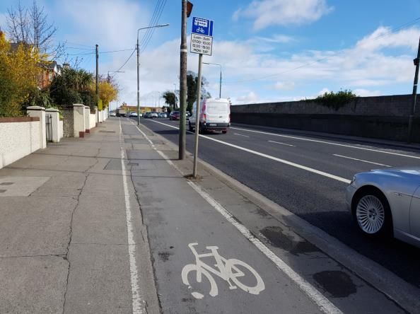
Strategic Housing Development at Swords                                                       Project reference: 379360
Road, Whitehall, Dublin 9                                                                     Project number: 60601744

The key objective of this MMP is to set out the infrastructural proposals and modal split targets for the development
in general terms. The Plan will then be further developed and informed by travel surveys undertaken by prospective
residents of the subject site once the proposed development, subject to consent, has been occupied.

1.4          Structure of this Mobility Management Plan
The remainder of this report is divided into the following sections:
•     Section 2 provides a review of the relevant guidance and policy documents that have helped establish the
      principles of this report;
•     Section 3 summaries the results of a detailed site audit to understand the transportation context in which the
      proposed development is located;
•     Section 4 provides a summary of the proposed development itself with regard to the key MMP objectives.
•     Section 5 outlines the estimated travel behaviours of the subject site;
•     Section 6 proposes a series of targets for the proposed development;
•     Section 7 outlines the measures to be implemented and considered as part of the MMP;
•     Section 8 details the monitoring and review process for the MMP; and
•     Section 9 presents a summary of the MMP.

Prepared for: Eastwise Construction Limited                                                                    AECOM
                                                                                                                   8
Strategic Housing Development at Swords                                                       Project reference: 379360
Road, Whitehall, Dublin 9                                                                     Project number: 60601744

2.           Policy Context
2.1          Overview
In order to complete this MMP, AECOM has made reference to the following documents and websites:
•       DCC Development Plan (2016 – 2022);
•       Transport Strategy for the Greater Dublin Area 2016 – 2035 (National Transport Authority (NTA));
•       Project Ireland 2040;
•       Smarter Travel: A Sustainable Transport Future: A new Transport Policy for Ireland, 2009 – 2020, (Department
        of Transport Tourism and Sport (DTTAS), 2008);
•       Greater Dublin Area Cycle Network Plan (National Transport Authority);
•       The National Cycling Policy Framework 2010; and
•       Transport for Ireland Dublin Area Train and Tram Services (Transport for Ireland).

The planning policies will aid in preparing a MMP that, upon implementation, will reduce overall single occupancy
vehicle dependence and increase more sustainable forms of transport and create a positive sustainable transport
environment for residents while adhering to the local and national policies.

2.2          Dublin City Council Development Plan
The Development Plan 2016 - 2022 sets out the vision, policies, strategies and objectives for planning and
sustainable development within the administrative area of DCC. In the context of the subject site a number of the
most relevant polices include:

2.2.1        Movement and Transport (MT) Policy 2 – Overarching
Whilst having regard to the necessity for private car usage and the economic benefit to the city centre retail core
as well as the city and national economy, to continue to promote modal shift from private car use towards increased
use of more sustainable forms of transport such as cycling, walking and public transport, and to co-operate with
the NTA, Transport Infrastructure Ireland (TII) and other transport agencies in progressing an integrated set of
transport objectives. Initiatives contained in the government’s ‘Smarter Travel’ document and in the NTA’s draft
transport strategy are key elements of this approach.

2.2.2        Movement and Transport (MT) Policy 3 – Public Transport
To support and facilitate the development of an integrated public transport network with efficient interchange
between transport modes, serving the existing and future needs of the city in association with relevant transport
providers, agencies and stakeholders.

2.2.3        Movement and Transport (MT) Policy 8 – Active Travel (Walking and Cycling)
To improve the city’s environment for walking and cycling through the implementation of improvements to
thoroughfares and junctions and also through the development of new and safe routes, including the provision of
foot and cycle bridges. Routes within the network will be planned in conjunction with green infrastructure objectives
and on foot of (inter alia) the NTA’s Cycle Network Plan for the Greater Dublin Area, and the National Cycle Manual,
having regard to policy GI5 and objective GIO18.

2.2.4        Movement and Transport (MT) Policy 13 – Mobility Management and Travel Planning
To promote best practice mobility management and travel planning to balance car use to capacity and provide for
necessary mobility via sustainable transport modes.

2.2.5        Movement and Transport (MT) Policy 18 – Car Club
To encourage new ways of addressing the parking needs of residents (such as car clubs) to reduce the requirement
for car parking.

2.3          Transport Strategy for the Greater Dublin Area, 2016 – 2035
The Transport Strategy for the Greater Dublin Area (2016 – 2035), which has been prepared by the NTA, with the
purpose of the strategy being:
To contribute to the economic, social and cultural progress of the Greater Dublin Area by providing for the efficient,
effective and sustainable movement of people and goods.

Prepared for: Eastwise Construction Limited                                                                    AECOM
                                                                                                                   9
Strategic Housing Development at Swords                                                        Project reference: 379360
Road, Whitehall, Dublin 9                                                                      Project number: 60601744

Chapter 5 of the Transport Strategy for the Greater Dublin Area, sets out the “strategic infrastructure that is
proposed to be delivered within the lifetime of the strategy”. The strategy proposals are presented by the various
modes of transport as follows:
•     Heavy Rail Infrastructure;
•     Light Rail Infrastructure;
•     Bus Infrastructure;
•     Cycling Infrastructure;
•     Walking; and
•     Road network.

Within each section of the modes of transport the NTA outline the proposed measures to be adopted when providing
a development and the considerations that have to be given.

2.4          Project Ireland 2040
The National Planning Framework (NPF), published in February 2018, is a national document intended to guide at
a high-level strategic planning and development for Ireland over the next 20+ years, so that as the population
grows, that growth is sustainable (in economic, social and environmental terms). The NPF details ten National
Strategic Outcomes’ and the National Development Plan 2018 – 2027 outlines how public capital investment over
the next ten years aims to secure the realisation of each of these under corresponding ‘Strategic Investment
Priorities’.
National Strategic Outcome No. 4 (p.53) states that:
An environmentally sustainable public transport system will enable growth and change; meet the significant
increase in travel demand and urban congestion while also contributing to our national policy vision of a low-carbon
economy. A step change is required under the NPF in putting in place environmentally sustainable public transport
systems in order to secure Ireland’s climate action goals. These must represent a decisive shift away from polluting
and carbon-intensive propulsion systems to new technologies such as electric vehicles and introduction of electric
and other alternatively fuelled systems for public transport fleets. The expansion of attractive and sustainable public
transport alternatives to private based car transport will reduce congestion and emissions and enable the transport
sector to cater in an environmentally sustainable way for the demands associated with longer term population and
employment growth envisaged under the NPF. Furthermore, the provision of safe alternative active travel options
such as segregated cycling and walking facilities can also help alleviate congestion and meet climate action
objectives by providing viable alternatives and connectivity.

2.5          Smarter Travel – A sustainable Transport Future
The Smarter Travel policy published in 2009 sets a goal to reduce work-related commuting by car nationally in
Ireland from 65 percent to 45 percent by 2020. The policy sets out forty-nine different actions to achieve a more
sustainable transport system grouped into four overarching actions outlined on page 29 of the policy as follows:
•     Actions to reduce distance travelled by private car and encourage smarter travel, including focusing
      population and employment growth predominantly in larger urban areas and the use of pricing mechanisms
      or fiscal measures to encourage behavioural change;
•     Actions aimed at ensuring that alternatives to the car are more widely available, mainly through a radically
      improved public transport service and through investment in cycling and walking;
•     Actions aimed at improving the fuel efficiency of motorised transport through improved fleet structure, energy
      efficient driving, and alternative technologies; and
•     Actions aimed at strengthening institutional arrangements to deliver the targets.

The Smarter Travel policy emphasises the potential of mobility management to encourage people to change their
travel behaviour and commitment to ensuring better integration of land use planning (Action 2) as well as to
requiring and encouraging large workplaces to develop and implement workplace travel plans (Action 8) and that
personalised travel plans should be prepared to encourage citizens to use public forms of transport (Action 9).

Prepared for: Eastwise Construction Limited                                                                     AECOM
                                                                                                                    10
Strategic Housing Development at Swords Project reference: 379360
Road, Whitehall, Dublin 9 Project number: 60601744
ACTION 2
We will ensure better integration of land use planning and transport policies in the relevant planning guidelines as
part of their ongoing review and we will avail of policy directives to give effect to specific measures needed to meet
the vision for sustainable travel.
The following will also be included in future planning guidelines:
• A general requirement that significant housing development in all cities and towns must have good public
transport connections and safe routes for walking and cycling to access such connections and local amenities
• Integration of cycling and public transport
• Promotion of targets requiring a minimum percentage of new residential and mixed-use development to take
place on brownfield/existing sites to consolidate urban growth and enable organic development of urban areas
from the centre out
• Ensuring a general minimum housing density of between 35 and 50 dwellings per hectare in urban areas of
suitable size and population and requiring substantially higher densities where local circumstances warrant,
particularly in high capacity public transport corridors
• Specification of a maximum permitted level of car parking for commercial sites, which have suitable public
transport facilities and are within walking/ cycling distance to amenities requirement that developments above
a certain scale have viable travel plans in place
• A requirement that development in urban rail corridors be high density and appropriate for public transport
use (e.g. not warehousing or other activities with low employment intensity)
• Guidance on the incorporation of cycling and walking policies in development plans
• A general restriction of the future development of out-of-town retail centres except in exceptional
circumstances and consideration of a similar requirement that parking charges be introduced for most existing
centres
• Encouragement of the use of local area plans and strategic development zones (SDZs) within major urban
areas as a way of improving the land use-transport interface, particularly to ensure that employment and
residential centres are co-located.
ACTION 8
Workplace Travel Plans encourage employers and employees to take steps to reduce dependency on the car and
to take alternative transport options. The Minister for Transport has already provided initial funding for a pilot
scheme managed by the Dublin Transportation Office (DTO) and the Department of Transport was the first
Department to introduce such a Plan. The Government has also introduced a parking levy on employee car parking
in key urban areas in the region of e200 per annum to dissuade use of the private car for commuting purposes. We
will now focus on encouraging alternative ways of travelling to work. We will, therefore:
▪ Work towards a requirement on organisations with over 100 staff to develop and implement workplace
travel plans;
▪ Provide support and guidelines for the development and implementation of workplace travel plans; and
▪ Seek a plan from the Office of Public Works to reduce car-parking spaces at Government offices where
alternative travel options are possible and require other public sector organisations to do likewise as part
of their workplace travel plans.
ACTION 9
Personalised travel plans aim to encourage individuals to take alternatives to car travel where these are available.
International experience shows that such plans must be accompanied by good targeted marketing and involve
incentives to encourage people to use alternatives to the private car. We will implement a programme to promote
Personalised Travel Plans aimed at citizens in areas served by Public Transport.
This MMP has been developed in consideration of national and local policy / strategy.
Prepared for: Eastwise Construction Limited AECOM
11Strategic Housing Development at Swords Project reference: 379360
Road, Whitehall, Dublin 9 Project number: 60601744
3. Existing Infrastructure
3.1 Overview
This section of the report outlines the available transport facilities within the receiving environment of the subject
site which can be utilised to reduce the number of single vehicle trips and promote the use of sustainable forms of
transport. A review of the existing baseline conditions has been undertaken including the existing site layout, the
local road network, pedestrian / cycling facilities, public transport and committed development.
3.2 Existing Site Access
There is an existing vehicular access at the north-western and south-western corners of the site. The northern
access is located at the existing 3-arm junction with Iveragh Road. The junction currently operates as a priority
controlled minor arm with signal heads controlling the major arm.
The permitted scheme comprised of a single vehicular access to the site off Swords Road. The permitted access
(ABP Reg Ref: PL 29N.238685, DCC Reg Ref: 3269/10) comprised of a new 4th arm connecting onto the existing
Swords Road / Iveragh Road signalised junction.
3.3 Local Road Network
The subject site is located approximately 3.9km north of Dublin City Centre, situated along the Swords Road which
is to from part of the BusConnects Corridor Project, Route No. 2 – Swords to City Centre. Travelling north from the
site will bring motorists to the M50 Junction 3 which allows motorists to access the wider road network.
The general location of the subject site in relation to the surrounding road network is illustrated in Figure 3.1 whilst
Table 3.1 indicates a number of key destinations that the residents of the proposed development may travel to and
their distance from the site.
Table 3.1 – Distances to Points of Interest
Ref Key Destinations Distance from site
1 Dublin City University (DCU) 1.0 km
2 Dublin Airport 6.9 km
3 Jamestown Business Park 4.3 km
4 Rosemount Business Park 8.0 km
5 Blanchardstown Shopping Centre 12.5 km
6 Dublin Industrial Estate 5.0 km
Technological University Dublin
7 4.5 km
(TUD)
8 Dublin City Centre 3.9 km
9 Dublin Port 5.0 km
10 Trinity College Dublin (TCD) 5.0 km
11 Ballymount Industrial Estate 11.0 km
Prepared for: Eastwise Construction Limited AECOM
12Strategic Housing Development at Swords Project reference: 379360
Road, Whitehall, Dublin 9 Project number: 60601744
2
4
3 Indicative Site
Location
5
1
6
7
9
8
10
11
Figure 3.1 – Points of Interest (Source: Google Maps)
3.4 Active Travel – Pedestrian and Cyclist Facilities
3.4.1 Swords Road
Swords Road (R132) is a regional two-way carriageway with 2 lanes running both north and southbound, with one
lane dedicated for buses in each direction. The speed limit along the carriageway is 50 km/hr in the vicinity of the
development. Footpaths are situated on both sides of the carriageway. An off-road cycle lane is provided on the
western side of the carriageway, which transitions into an on road cycle lane along the approach of Iveragh Road.
To the north, Swords Road intersects with Collins Avenue West (R103), as part of an orbital route connecting
Killester / Donnycarney with Whitehall, Ballymun, Glasnevin and Finglas. The existing junction at the Swords Road
/ Iveragh Road / Site Access junction consists of a signalised pedestrian crossing on the northern arm of the junction
which is operated by pedestrians pressing the push button. A yellow box junction is provided to prohibit vehicles
blocking vehicles exiting / entering the Iveragh Road.
Figure 3.2 – Swords Rd facing North, at Iveragh Road Figure 3.3 – Swords Road facing Northbound
Approach
Prepared for: Eastwise Construction Limited AECOM
13Strategic Housing Development at Swords Project reference: 379360
Road, Whitehall, Dublin 9 Project number: 60601744
3.5 Sustainable Transport – Bus Services
As graphically illustrated in Figure 3.4 below, the site is situated to benefit from bus transport connections allowing
residents, and visitors to travel by this sustainable mode.
The closest bus stops to the site are located along the Swords Road, which are within a 200m walking catchment
of the site. These bus stops are operated by Dublin Bus. Figure 3.4 illustrates the location of the bus stops in
relation to the development with Table 3.2 detailing the number of services per day and the routes.
Bus Route No:
44
Bus Route No:
16
Bus Route No’s:
1, 16, 33, 41,
41b, 41c, 44
Bus Route No’s:
1, 16, 16c, 33,
41, 41b, 41c, 44
Site Location
Figure 3.4 – Bus Stops in the Vicinity of the Site (Source: www.journeyplanner.transportforireland.ie)
Table 3.2 – Bus Timetables (Source: www.journeyplanner.transportforireland.ie)
Route No. of Services
Operator Route
No. Monday to Friday Saturday Sunday
Santry – Whitehall – Dublin City –
1 Dublin Bus Every 15 mins Every 20 mins
Sandymount
Dublin Airport – Whitehall – Drumcondra – Every 10 to 15
16 Dublin Bus Every 15 mins
Dublin City - Ballinteer mins
Dublin Airport – Santry – Whitehall –
16c Dublin Bus 3 services per day (From 23:00 – 23:30)
Ballybough – Dublin City
Dublin City – Drumcondra – Whitehall –
33 Dublin Bus 1 service every hour
Dublin Airport – Swords – Lusk – Balbriggan
Dublin City – Drumcondra – Whitehall –
41 Dublin Bus Every 20 mins Every 30 mins Every 20 mins
Dublin Airport – Swords – Knocksedan
Dublin City – Drumcondra – Whitehall – 3 services per 4 services per
41b Dublin Bus 5 services per day
Dublin Airport – Swords – Rowlestown day day
Dublin City – Drumcondra – Whitehall –
41c Dublin Bus Every 20 mins Every 30 mins Every 20 mins
Dublin Airport – Swords – Knocksedan
Whitehall – Drumcondra – Dublin City –
44 Dublin Bus 1 service every hour
Dundrum – Stepaside – Enniskerry
3.6 Sustainable Transport – Heavy Rail Network
The closet railway station to the site is the Drumcondra Train Station located 2.2 km (26 min walk) south of the
subject site. The Drumcondra Station is part of the Western Commuter service which provides rail services
eastward to Dublin Connolly and westwards towards Sligo. Figure 3.5 illustrates the site location in relation to the
Drumcondra Train Station.
Prepared for: Eastwise Construction Limited AECOM
14Strategic Housing Development at Swords Project reference: 379360
Road, Whitehall, Dublin 9 Project number: 60601744
2.2 km Site Location
(26 min walk)
Drumcondra
Train Station
Figure 3.5 – Site Proximity to Train Station (Source: www.journeyplanner.transportforireland.ie)
3.7 Sustainable Transport – Light Rail Network
The closet railway station which offers DART services is the Killester Train Station located 3.3 km (39 min walk)
east of the subject site. The Killester Station is part of the Northern Commuter service which provides light rail
services north to Malahide and further to Dundalk and Belfast by heavy rail and south towards Connolly and Bray
which continues further to the Rosslare Europort by heavy rail. Figure 3.6 illustrates the site location in relation to
the Killester Train Station.
Site Location
Killester Train
3.3 km Station
(39 min walk)
Figure 3.6 – Site Proximity to Nearest DART Station (Source: www.journeyplanner.transportforireland.ie)
3.8 Sustainable Transport – Car Sharing
There are 13 GoCar hire stations located within a 1.5km walking catchment of the subject site. GoCar members
can book cars online or via the app for durations of as little as an hour. They then unlock the car with their phone
or a GoCard; the keys are in the car, with fuel, insurance and city parking all included. The benefits of such car
sharing services include:
• The reduction of cars on the road and therefore traffic congestion, noise and air pollution;
• Frees up land traditionally used for private parking spaces;
Prepared for: Eastwise Construction Limited AECOM
15Strategic Housing Development at Swords Project reference: 379360
Road, Whitehall, Dublin 9 Project number: 60601744
• Encourages and potentially increases use of public transport, walking and cycling as the need for car
ownership is reduced;
• Car sharing allows those who cannot afford a car the opportunity to drive, encouraging social inclusivity;
and
• Car share replaces approximately 20 private car parking spaces.
The locations of the GoCar bases are illustrated in Figure 3.7 with Table 3.3 providing additional details in relation
to walking distance from the site and the type of GoCar vehicle available.
2
1 7
4
3 5
6
Site Location
8
10
9
12
11
13
Figure 3.7 – GoBase Locations (Source: www.GoCar.ie)
Table 3.3 – GoBase Details
Approximate Distance from the
Ref No. Go Base Location Vehicle Class
development
1 Dublin City University, Collins Avenue GoCity 1.00 km
2 Shanowen Road GoCity 1.50 km
3 Iveragh Road GoCity 0.35 km
4 Whitehall Car Park GoCargo 0.20 km
5 Collins Avenue West – Whitehall GoCity 0.40 km
6 Collinswood GoTripper 0.85 km
7 The Park – Beaumont GoTripper 1.50 km
8 Sion Hill Road GoCity 1.20 km
9 Griffith Walk GoCity 1.40 km
10 Achill Road GoCity 1.20 km
11 Ormond Road, Drumcondra GoCity 1.40 km
12 Dublin City University, St. Pat’s Go City 1.40 km
13 Clonturk Park GoCargo, GoTripper 1.50 km
Prepared for: Eastwise Construction Limited AECOM
16Strategic Housing Development at Swords Project reference: 379360
Road, Whitehall, Dublin 9 Project number: 60601744
3.9 Emerging Transport Infrastructure
3.9.1 Local Road Proposals
The Dublin City Development Plan 2016 – 2022, has outlined both short (6 years) and long-term road network
proposals for the Dublin City environs.
Upon review of the Development Plan, no roads objectives have been identified within the vicinity of the subject
site.
3.9.2 Cycle Network Proposals
In the vicinity of the subject site, it is planned to upgrade the cycle facilities along the Swords Road, Collins Avenue
and Griffith Avenue. It is understood that the cycle facilities to be provided along the Swords Road will be part of
the BusConnects redesign. Figure 3.8 illustrates the existing cycle facilities in the vicinity of the subject site with
Figure 3.9 illustrating the proposed cycle network upgrades as part of the Cycle Network Plan for the Greater Dublin
Area
Site Location
Figure 3.8 – Existing Cycle Facilities (Source: GDA Cycle Network Plan, National Transport Authority)
Prepared for: Eastwise Construction Limited AECOM
17Strategic Housing Development at Swords Project reference: 379360
Road, Whitehall, Dublin 9 Project number: 60601744
Site Location
Figure 3.9 – Proposed Cycling Facilities (Source: GDA Cycle Network Plan, National Transport Authority)
3.9.3 Bus Network Proposals
The National Transport Authority (NTA) has put forward proposals to upgrade a number of core bus corridors from
the Dublin environs to the City Centre under the title ‘BusConnects’. The aim of the project is to:
• ‘Make bus journeys faster, predictable and reliable;
• New bus stops and better facilities;
• More efficient network, connecting more places and carrying more passengers;
• Updated ticketing systems and implementing a cashless payment system with a simpler fare structure; and
• Improving the cycling network and making it safer.’
As part of the BusConnects scheme the current bus network is to be revised and more frequent and efficient
services are to be provided across the Dublin environs. Table 3.4 details the proposed routes in the vicinity of the
subject site with Figure 3.10 illustrating the proposed routing.
Table 3.4 – Revised Bus Network Routes
Route Route Type Route Frequency
A1 Spine / Branch Routes Beaumont – City Centre – Terenure – Templeogue – Ballycullen Every 10 – 15 mins
A2 Spine / Branch Routes Airport – City Centre – Terenure – Ballinteer – Dundrum Every 10 – 15 mins
A3 Spine / Branch Routes Shanowen Rd – City Centre – Rathmines – Terenure – Tallaght Every 10 – 15 mins
A4 Spine / Branch Routes Swords – City Centre – Rathmines – Terenure – Nutgrove Every 10 – 15 mins
Clontarf Rd Station – Marino – Glasnevin – Broombridge –
N2 Orbital Route Every 20 mins
Stoneybatter – Heuston Station
Blanchardstown Centre – Finglas – DCU – Whitehall – Killester –
N4 Orbital Route Every 10 – 15 mins
Spencer Dock
Glen Ellan Rd – Swords Rd – Drumcondra – City Centre –
82 Other City Bound Route Every 10 – 15 mins
Merrion Sq
Ballymun – Wadelai – Glasnevin – Drumcondra – City Centre –
94 Other City Bound Route Every 10 – 15 mins
Parnell Sq
Swords Business Park – Drynam Rd – Clongriffin Station –
280 Local Routes Every 40 mins
Beaumont – Whitehall – DCU
Prepared for: Eastwise Construction Limited AECOM
18Strategic Housing Development at Swords Project reference: 379360
Road, Whitehall, Dublin 9 Project number: 60601744
Figure 3.10 – Proposed Public Transport Services (Source: www.busconnects.ie)
3.9.4 Metro Link
MetroLink is a proposed large scale infrastructure project which will provide a metro line within the Dublin Area.
The proposed scheme will start in Swords and terminate in Charlemont to tie in with the Luas Green Line. As part
of the scheme, it is proposed to provide 16 no. stations which will include locations such as the Dublin Airport,
Glasnevin and O’ Connell Street. While the project is currently in its public consultation phase, a preferred route
has been published along with the locations of proposed metro stations. It is anticipated that the completed
Metrolinks project will be delivered in 2027. The subject site is located approximately 1.8km from the proposed
Collins Avenue Station which has been illustrated in Figure 3.11.
Proposed Collins 1.8 km
Avenue Station (22 min walk)
Proposed Metrolink
Route
Site Location
Figure 3.11 – Metrolink Emerging Preferred Route (Source: www.metrolink.ie)
Prepared for: Eastwise Construction Limited AECOM
19Strategic Housing Development at Swords Project reference: 379360
Road, Whitehall, Dublin 9 Project number: 60601744
4. Characteristics of Proposals
4.1 General
This Section outlines the traffic and transport elements of the proposed development and demonstrates that the
scheme is consistent with the main MMP objective, to encourage a shift from single occupancy private car use
towards sustainable alternatives.
4.2 Proposed Development
The proposed development entails 475 no. residential apartments with a creche and a café unit consisting of the
following breakdown:
Table 4.1 – Proposed Schedule of Accommodation
Land Use Type Quantum Total
Studio Apartment 26 units
1 Bedroom Apartment 179 units
Residential 475 units
2 Bedroom Apartment 251 units
3 Bedroom Apartment 19 units
Retail Café 99.0 sq.m (GFA) 99.0 sq.m
Education Creche 414.0 sq.m (GFA) 414.0 sq.m
Residential* 261 spaces
Car Parking (Basement) Creche Staff 5 spaces 284 spaces
Accessible 18 spaces
Residential 44 spaces
Creche set-down 4 spaces
Car Parking (At-grade) Accessible 5 spaces 64 spaces
Café Staff 1 space
Car Club 10 spaces
Long Stay 480 Spaces
Cycle Parking 527 Spaces
Short Stay 47 spaces
Motorcycle Parking Basement 11 spaces 11 spaces
* = Inclusive of 35 Electric Vehicle
4.3 Pedestrian and Cyclist Permeability
There are a number of access points along the western boundary of the site onto the Swords Road which facilitate
safe access and permeability to / from the site with Figure 4.1 indicating the location of these access points. Once
residents enter the site there are paved footways which will allow residents to easily access their apartment block,
please refer to the architects site layouts.
The proposed vehicle access arrangement to the site from Swords Road has been designed to accommodate
pedestrians by providing pedestrian crossings on all arms of the junction, which is an improvement to the current
situation. Moreover this access arrangement does not preclude the delivery of BusConnects.
Prepared for: Eastwise Construction Limited AECOM
20Strategic Housing Development at Swords Project reference: 379360
Road, Whitehall, Dublin 9 Project number: 60601744
Pedestrian /
Cyclist Access
Pedestrian /
Cyclist Access
Figure 4.1 – Pedestrian / Cyclist Access Points (Courtesy: C+W O’Brien Architects)
4.4 Cycle Parking Provision
The proposed cycle parking provision has been designed to encourage cycling as a key mode of travel to and from
the development. The cycle parking spaces will comprise of secure cycle spaces for residents of the apartment
units within the basement and at grade with standard ‘Sheffield style’ cycle parking stands for visitors.
The DCC Development Plan Standards (2016 – 2022) and the Sustainable Urban Housing Design of New
Apartments Guidelines (December 2020) have been considered when determining a suitable amount of cycle
parking for the proposed development.
Table 4.2 illustrates the proposed cycle parking provision against DCC’s and the Sustainable Urban Housing
parking standards.
Table 4.2 – Cycle Parking Requirements
Cycle Parking Minimum Cycle Parking Number of Cycle Parking Total Number of Cycle
National Standards
Requirements Standard Spaces Required Parking Spaces Required
Apartment
DCC Development 1 cycle space per unit 475
Units (475)
Plan standards 475
(2016 – 2022)
Visitor Spaces TBD on case by case NA
The Sustainable Bedrooms 1 cycle space per
Urban Housing 1502
(1502) bedroom
Design of New
Apartments 1,740
guidelines
Visitor Spaces 1 cycle space per 2 units 238
(December 2020)
A total of 527 cycle parking spaces are proposed within the site to cater for the proposed development.
Table 4.2 above demonstrates that the cycle parking provision of 527 no. spaces is compliant with the DCC
Development Plan standards (475 no. spaces) but below the Design Standards for New Apartments guidelines,
which recommends provision of 1 cycle space per bedroom along with 1 visitor space per 2 units.
Prepared for: Eastwise Construction Limited AECOM
21Strategic Housing Development at Swords Project reference: 379360
Road, Whitehall, Dublin 9 Project number: 60601744
AECOM considers the proposed cycle parking provision to be appropriate when cognisance is given to the
accessibility of the site to existing walking and public transport infrastructure in the surrounding area.
It is proposed within this MMP to monitor the usage of the cycle stands following the opening of the proposed
development. Should demand meet the proposed level of cycle parking, the management company will allocate
additional cycle parking for the development i.e. increasing the number of cycle stands. There is ample space at
surface level to add more cycle stands following a review of the demand.
The proposed cycle parking spaces will comprise of the following:
• 480 no. spaces in secure bike storage within the basement and at grade for residents; and
• 47 no. spaces in the form of Sheffield stands at-grade for visitors.
Access to the basement level cycle parking will be permitted into the bike stores via the use of a key or fob,
providing a sense of security for cyclists.
It is therefore anticipated that the proposed cycle parking provision is sufficient to accommodate predicted demand,
whilst also complying with DCC’s minimum cycle parking standards.
4.5 Car Parking Provision
It is proposed to provide a total of 348 car parking spaces on site, 328 no. spaces dedicated to the 475 no.
residential units (279 at basement level and 49 at grade), 4 set-down spaces at grade adjacent to the Creche, 5
no. spaces within the basement for creche staff with 35 EV spaces and 1 car parking space for staff for the café.
10 no. Car Club spaces are proposed at grade.
The proposed car parking provision has been designed to cater for the expected car parking demand of the site
whilst also considering the residential amenity of prospective residents.
The TTA sets out the various policy and research documents used to establish the projected car parking demand.
Following the assessment outlined in the TTA, it is determined that the proposed quantum of 0.69 of a car parking
space per apartment unit is sufficient to cater for the anticipated demand of perspective residents of the site.
Prepared for: Eastwise Construction Limited AECOM
22Strategic Housing Development at Swords Project reference: 379360
Road, Whitehall, Dublin 9 Project number: 60601744
5. Existing Travel Patterns
5.1 Overview
In order to gain an understanding of the existing travel behaviours of the future residents of the development,
reference has been made to the National Household Travel Survey and the 2016 Census Data. This data will
provide an understanding of the travel patterns of the existing residents in the area and help inform the future travel
patterns of perspective residents.
5.2 National Household Travel Survey
AECOM has made use of the NTA National Household Travel Survey (NHTS) 2018. The National Household Travel
Survey is a nationally representative study of Irelands travel habits. The survey comprised of a survey administered
to 5,906 households with a 3-day travel diary to be completed by each person in the house over the age of 4, a
total of 10,289 diaries were completed. These travel diaries accounted for 62,307 trips and detailed factors, such
as:
• Distance travelled;
• Duration of journeys;
• Mode of Transport;
• Reason for the journey;
• The day of travel;
• Time of outward journey;
• Number of people taking the trip; and
• Demographic profiles.
5.2.1 Dublin City
To determine the trip pattern of the Dublin City Region, reference has been made to chapter 6 of the NHTS which
details the travel behaviours of those surveyed in the Dublin City Region, Figure 5.1 illustrates the site location in
relation to the Dublin City Region as indicated in the NHTS. The Dublin City Region only includes for the areas
within the extents of DCC’s administrative area.
Site Location
Figure 5.1 – Site location in the context of the Dublin City Region (Source: NHTS, 2018)
Prepared for: Eastwise Construction Limited AECOM
23You can also read