Transport Impact Review - BEDFORD NORTH CORRIDOR
←
→
Page content transcription
If your browser does not render page correctly, please read the page content below

Transport Impact Review
BEDFORD NORTH CORRIDOR

Bedford North Corridor – Transport Impact Review

PROJECT                Bedford North Corridor – Transport Impact Review
File                   81113-514-FLYT-REP-0004 Rev4
Revision               Description                 Originator             Review      Date
0                      Draft                         MDR                   CAS     09/04/2021
1                      Final                         MDR                   CAS     20/04/2021
2                      Amended Final                 MDR                   CAS     03/05/2021
3                      Amended Final v2              MDR                   CAS     09/06/2021
4                      Finalised Conclusions         MDR                   CAS     05/07/2021
Bedford North Corridor – Transport Impact Review

                                                                                                                                                                                                                                                           3.8.2           Grand Promenade ............................................................................................................................................................................................. 16
Contents                                                                                                                                                                                                                                                   3.8.3           Coode Street........................................................................................................................................................................................................ 16

1.     Introduction and Background ........................................................................................................................................................................................... 3                           3.8.4           Clement Street ................................................................................................................................................................................................... 17

     1.1          Transport Impact Review ....................................................................................................................................................................................... 4                        3.8.5           Study Area Residential Streets ................................................................................................................................................................... 17

2.     Planning and Demographic Context .............................................................................................................................................................................. 5                                 3.9          Existing Vehicular Access Arrangements .................................................................................................................................................... 17

     2.1          Perth and Peel @3.5 million ................................................................................................................................................................................. 5                        3.10         Existing Car Parking Arrangements ............................................................................................................................................................... 18

     2.2          State Planning Policies and Local Planning Framework .......................................................................................................................... 6                                                 4.     Analysis of Transport Networks .................................................................................................................................................................................. 19

     2.3          City of Stirling Walter Road West Neighbourhood Centre Local Development Plan ............................................................... 6                                                                                        4.1          Development Scenarios – Residential Dwellings ..................................................................................................................................... 19

     2.4          Demographic Analysis ............................................................................................................................................................................................. 6                   4.2          Development Scenario – Commercial Floor Area.................................................................................................................................... 20

       2.4.1           Population growth ............................................................................................................................................................................................... 6               4.3          Understanding Transport Networks Impacts of Development Scenarios ................................................................................... 21

       2.4.2           Population Age ...................................................................................................................................................................................................... 6           4.4          High-Level Assessment of Traffic Signal Controlled Intersections ................................................................................................ 23

       2.4.3           Household/Family Type.................................................................................................................................................................................... 6                       4.5          Future Traffic Volumes ........................................................................................................................................................................................ 23

       2.4.4           Car Ownership ....................................................................................................................................................................................................... 7           4.6          Car Parking Considerations ................................................................................................................................................................................ 26

3.     Existing Situation ................................................................................................................................................................................................................... 8     5.     Integration with Surrounding Area ............................................................................................................................................................................. 29

     3.1          Regional Context ........................................................................................................................................................................................................ 8            5.1          Main Street Considerations ............................................................................................................................................................................... 29

     3.2          Local Context ............................................................................................................................................................................................................... 8        5.2          Public Transport Access Considerations ..................................................................................................................................................... 30

     3.3          Location History ......................................................................................................................................................................................................... 9           5.3          Walking and Bicycle Riding Networks Considerations .......................................................................................................................... 33

     3.4          Existing Land Uses .................................................................................................................................................................................................... 9         6.     Conclusions............................................................................................................................................................................................................................. 35

     3.5          Pedestrian Connections ....................................................................................................................................................................................... 10                      6.1          Introduction ............................................................................................................................................................................................................... 35

     3.6          Bicycle Routes .......................................................................................................................................................................................................... 12           6.2          Existing Situation .................................................................................................................................................................................................... 35

       3.6.1           Existing Bicycle Network ............................................................................................................................................................................... 12                       6.3          Analysis of Transport Networks ...................................................................................................................................................................... 35

       3.6.2           Future Bicycle Network .................................................................................................................................................................................. 13                        6.3.1           Development Scenarios .................................................................................................................................................................................. 35

     3.7          Public Transport Access ...................................................................................................................................................................................... 14                        6.3.2           High-Level Assessment – Intersections................................................................................................................................................. 35

       3.7.1           Train Services...................................................................................................................................................................................................... 14             6.3.3           High-Level Assessment – Traffic Volumes........................................................................................................................................... 35

       3.7.2           Bus Services ......................................................................................................................................................................................................... 14         6.4          Broader Transport Considerations ................................................................................................................................................................. 35

     3.8          Local Road Network .............................................................................................................................................................................................. 15

       3.8.1           Walter Road West ............................................................................................................................................................................................ 16
Bedford North Corridor – Transport Impact Review

1.       INTRODUCTION AND BACKGROUND                                                                                     It is noted in the Urban Design Study Report (Hames Sharley, 2021), that the Bedford North area is in transition – the
                                                                                                                         suburban qualities that have made it a great place to live have attracted more residents and businesses to the area,
In 2020 the City of Bayswater (the City) commissioned Hames Sharley to prepare an Urban Design Study for the
                                                                                                                         including:
Bedford North Corridor, with support of Shape Urban (community engagement) and Flyt (transport and movement).
                                                                                                                             •   Original high-quality brick detached houses with generous yards.
The Bedford North Corridor study area covers the northern portion of Bedford generally bounded by Walter Road West
                                                                                                                             •   Easy access to the Morley Activity Centre and employment areas beyond (in Malaga and Bayswater).
(to the north), Coode Street (to the east), Clement Road (to the south) and Salisbury Street (to the west) – with some
                                                                                                                             •   Education facilities at ECU Mt Lawley, Mt Lawley High School and a range of primary and non-government
additional properties that fringe R.A. Cooke Reserve and Birkett Reserve – as shown in Figure 1.
                                                                                                                                 schools.
                                                                                                                             •   Easy access to road, suburban rail (a quick trip to Meltham Station) or direct buses into Perth CBD or Morley.
                                                                                                                             •   Relatively affordable price points for new homeowners or renters.

                                                                                                                         In addition, it is noted in the Urban Design Study Report (Hames Sharley, 2021) that the increased desirability of the
                                                                                                                         Bedford North area has increased traffic volumes on Walter Road West, seen backyard infill subdivision and
                                                                                                                         development, and greater use of public open space in the area.

                                                                                                                         As part of the Urban Design Study the future for Bedford North has been a focus for community discussions – the
                                                                                                                         following three statements present a vision for Bedford North based on community input into the Urban Design Study.

                                                                                                                             1. “Community life is built around places to meet, eat, drink, shop and play. Bedford North can become a place
                                                                                                                                 where corner stores, cafes and small workplaces pop up in new mixed use developments along a pedestrian
                                                                                                                                 friendly Walter Road.”
                                                                                                                                 •    Considerations for Bedford North:
                                                                                                                                            o   Promoting mixed use development on important roads.
                                                                                                                                            o   Promoting slower speed pedestrian environments along important roads.
                                                                                                                                            o   Exploring opportunities to upgrade and enhance existing open spaces.

                                                                                                                             2. “Shade and shelter are critical to a quality suburban experience, and Bedford North’s next generation of
                                                                                                                                 development can leave space for mature trees to grow.”
                                                                                                                                 •    Considerations for Bedford North:
                                                                                                                                            o   Design provisions that promote growth of mature trees canopy in yard spaces and setbacks.
                                                                                                                                            o   Exploring opportunities to bring more street trees onto Walter Road West.
                                                                                                                                            o   Exploring opportunities to plant more trees on existing reserves/verges throughout Bedford North.

                                                                                                                             3. “Opening new homes onto Bedford North’s streets will help residents stay connected. Courtyards, balconies, low
                                                                                                                                 fences and front gates will bring in more ways to strengthen neighborhood relationships over the long term.”
                                                                                                                             •   Considerations for Bedford North:
                                                                                                                                      o     Design provisions that promote active living towards the front of the street.
                                                                                                                                      o     Exploring opportunities for Walter Road West to evolve into a more pedestrian friendly street, similar to
                                                                                                                                            many other regional roads through the inner-north.
Figure 1 Bedford North study area (source: Bedford North Urban Design Study, Hames Sharley)
Bedford North Corridor – Transport Impact Review

1.1       Transport Impact Review
A high-level transport impact review has been developed by Flyt to support the Urban Design Study for the Bedford
North Corridor.

This high-level transport impact review report has been prepared to cover the broad requirements of the WAPC
Transport Impact Assessment Guidelines Volume 2 Planning Schemes, Structure Plans and Activity Centre Plans (August
2016).

The primary focus of the high-level transport impact review for the Bedford North Corridor is to:

    •    Outline the existing land uses within the study area.
    •    Outline the existing movement networks through the study area.
    •    Consider a range of sources of transport data to outline the existing movement patterns
    •    Consider the urban growth scenarios identified in the Urban Design Study (Hames Sharley, 2021) – and consider
         the impacts of these growth scenarios on the transport network based on existing transport count data and
         future year modelling by Main Roads WA.
    •    Considering the above items, provide a series of conclusions in relation to the future development of the Bedford
         North study area.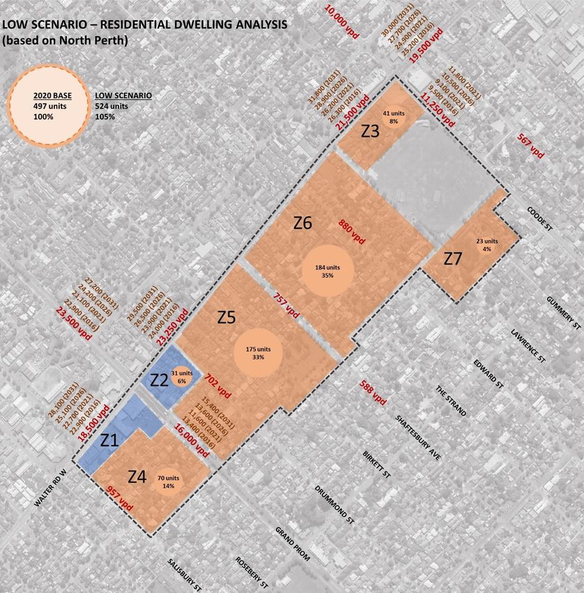
Bedford North Corridor – Transport Impact Review

2.            PLANNING AND DEMOGRAPHIC CONTEXT                                                                                                         Under Perth and Peel @3.5 million growth is proposed to occur primarily via infill development due to the lack of
                                                                                                                                                       availability of land. Figure 2 shows that the Walter Road West study area makes up part of the urban corridor network.
                                                                                                                                                       The urban corridor network has the following description:
2.1           Perth and Peel @3.5 million
                                                                                                                                                       “Urban corridors provide connections between activity centres and maximise the use of high-frequency and priority
The Perth and Peel @3.5 million suite of strategic land use planning documents provide a framework for future growth in
                                                                                                                                                       public transport. Urban corridors shown in the framework represent significant opportunities to accommodate increased
the Perth and Peel regions. The strategy recognises the benefits of a consolidated and connected city utilising the
                                                                                                                                                       medium-rise higher density residential development by good quality, high-frequency public transport.”
region’s previous historic patterns of urban growth.
                                                                                                                                                                                                                                               (source: Perth and Peel @3.5 million)
This strategy promotes more efficient use of land and infrastructure and maintains a target of 47% of new development
in the form of urban infill. The frameworks provide for different lifestyle choices, vibrant nodes for economic and social
activity and a more sustainable urban transport network.

Perth and Peel @3.5 million identifies that the City has an estimated population target of 100,000 by 2050 representing
an increase of 34,660 from 2011-2050. To facilitate this growth, the framework seeks to achieve a more consolidated
urban form, underpinned by the ten key principles identified in Table 1 which demonstrate how growth is accommodated.

Table 1 – Principles for Urban Consolidation (source: Perth and Peel @3.5 million)
 Principle        Description
                  Provide well-designed higher-density housing that considers local context, siting, form, amenity and the natural environment, with
 Housing
                  diverse dwelling types to meet the needs of the changing demographics.
 Character and    Ensure the attractive character and heritage values within suburbs are retained and minimise changes to the existing urban fabric,
 Heritage         where appropriate.
                  Support urban and economic development of the activity centres network as places that attract people to live and work by
 Activity
                  optimising land use and transport linkages between centres; protecting identified employment land from residential encroachment,
 Centres
                  where appropriate, and avoiding contiguous linear or ribbon development of commercial activities beyond activity centres.
                  The focus for higher-density residential development. Where appropriate, located along transit corridors and promoted as
 Urban
                  attractive places to live by optimising their proximity to public transport while ensuring minimal impact on the surrounding urban
 Corridors
                  fabric and the operational efficiency of the regional transport network.
                  Where appropriate, focus development in and around station precincts (train stations or major bus interchanges as set out under
 Station
                  the METRONET initiative) and promote these precincts as attractive places to live and work by optimising their proximity to public
 Precincts
                  transport while ensuring minimal impact on the operational efficiency of the regional transport network.
 Industrial       Promote the current and proposed supply and/or development of industrial centres as key employment nodes and prevent
 Centres          incompatible residential encroachment on these areas.
 Public           Ensure that most transit corridors are supported by quality higher-density residential land uses and identify where new or
 Transport        improved public transport services will be needed to meet long-term growth, especially current and future train station precincts.
                  Ensure more efficient use of and add value to existing and planned infrastructure to achieve a more sustainable urban
 Infrastructure   environment. Protect existing and proposed infrastructure from incompatible urban encroachment to promote a system where
                  land use developments and infrastructure are mutually compatible.
                  Preserve, enhance and consolidate the green network of parks, rivers, sport/recreation areas, facilities for active open space,
 Green
                  conservation and biodiversity areas, and areas with a high level of tree canopy coverage, considered important for the health and
 Network
                  wellbeing of the community.
                  Avoid, protect and mitigate environmental attributes and promote development that contributes to maintaining air quality and
 Protection
                  minimises risks of inundation from sea-level rise, flooding or storm surge events and bushfire damage.                               Figure 2 Central Sub-Region Planning Framework with Walter Road West highlighted (source: Perth and Peel @3.5 million)
Bedford North Corridor – Transport Impact Review

2.2       State Planning Policies and Local Planning Framework                                                                 Collaboration between the City of Stirling and City of Bayswater will be critical to enhance the opportunities for Bedford
                                                                                                                               North. Matters such as: Walter Road West streetscape upgrades, car parking management and place planning will all
The Bedford North Corridor Study is influenced by a range of State planning policies and local planning framework –
                                                                                                                               benefit from a collaborative approach.
these are covered in detail in the Urban Design Study for the Bedford North Corridor (Hames Sharley, 2021). The key
policies and strategies are:
                                                                                                                               2.4       Demographic Analysis
    •   State Planning Policies:
                                                                                                                               The Bedford North Corridor Urban Design Study (Hames Sharley, 2021) includes an analysis of the Bedford North
            o    State Planning Policy 7.0 – Design of the Built Environment
                                                                                                                               community’s defining characteristics and how they influence the Study. From a movement and transport perspective the
            o    State Planning Policy 7.2 – Precinct Design
                                                                                                                               key demographic information for the suburb of Bedford is age, household/family type and car ownership.
            o    State Planning Policy 7.3 – Residential Design Codes Volume 1 – Detached and Grouped Dwellings
            o    State Planning Policy 7.3 – Residential Design Codes Volume 2 – Apartments
                                                                                                                               2.4.1     Population growth
            o    State Planning Policy 5.4 – Road and Rail Noise
    •   Local Planning Framework:                                                                                              Between the Census periods of 2006 and 2016, the population of Bedford increased by 18.9% from 4,575 to 5,438
            o    Local Housing Strategy                                                                                        persons. This is a similar growth to neighboring suburbs such as Inglewood (12%), Maylands (20%), Bayswater (19%),
            o    Town Planning Scheme No. 24                                                                                   Morley (16%) and Dianella (9%).
            o    Building Bayswater and Local Planning Strategy                                                                With Bedford being an established residential area, a population growth of 15%-20% between 2006 and 2016 would be
            o    Landscaping Policy and Landscaping Guidelines                                                                 expected as the availability of new land and opportunities for redevelopment are limited.

2.3       City of Stirling Walter Road West Neighbourhood Centre Local                                                         2.4.2     Population Age

          Development Plan                                                                                                     As noted in the Urban Design Study (Hames Sharley, 2021), the age of a community can help determine the stages of
                                                                                                                               life people are typically in – with age and life cycle having a direct correlation to a variety of factors associated with
The City of Stirling Walter Road West Neighbourhood Centre Local Development Plan guides new development in the
                                                                                                                               housing. A summary of key findings is provided below:
formerly zoned Dianella Industrial Area, to the west of the current study site. The plan has several objectives, of which
some relate directly to Walter Road West. These are:                                                                               •   In 2016 31% of people in Bedford were aged 24 years or younger – suggesting a relatively strong
                                                                                                                                       representation of households with children and young adults present.
    •   To establish Walter Road West as a local ‘main street’ activity centre with street-focused retail and other
                                                                                                                                   •   The proportion of adults in the home making and career phases (aged 25-54 years) is almost 45% in Bedford,
        commercial uses.
                                                                                                                                       slightly above the Greater Perth level of 43%.
    •   To set buildings back from Walter Road West to enable public realm enhancements such as wider footpaths and
                                                                                                                                   •   Retirees and Seniors (aged 55 years+) are more prevalent in Bedford in contrast to Greater Perth – 24.5%
        street trees.
                                                                                                                                       compared to 22.7%. Options for housing to accommodate the needs of these households who may be no longer
    •   Provisions to ensure all mixed-use buildings fronting on to Walter Road West will have a continuous solid canopy
                                                                                                                                       working and have children leaving home are important to consider. Smaller lots to maintain, secure and compact
        for pedestrian shelter.
                                                                                                                                       dwellings, well serviced by public transport and do not cost a lot to run or maintain are attractive to a lone
    •   A public plaza is proposed on the corner of Walter Road West and Grand Promenade and another on the corner
                                                                                                                                       person or older couple households.
        of Walter Road West and Cleveland Street.
    •   The building types along Walter Road West include multi-storey residential limited to 5 storeys. The ground
                                                                                                                               2.4.3     Household/Family Type
        floor is to be used for non-residential, whilst the upper floors are to be a mix of residential and non-residential.
                                                                                                                               Bedford has 72% of family households compared to 73% for Greater Perth – which aligns with the age profile.
The production of this Local Development Plan has helped to inform the design responses in the Bedford North Corridor
Study (Hames Sharley, 2021), in particular the way commercial lots in the Bedford North Centre may be redeveloped.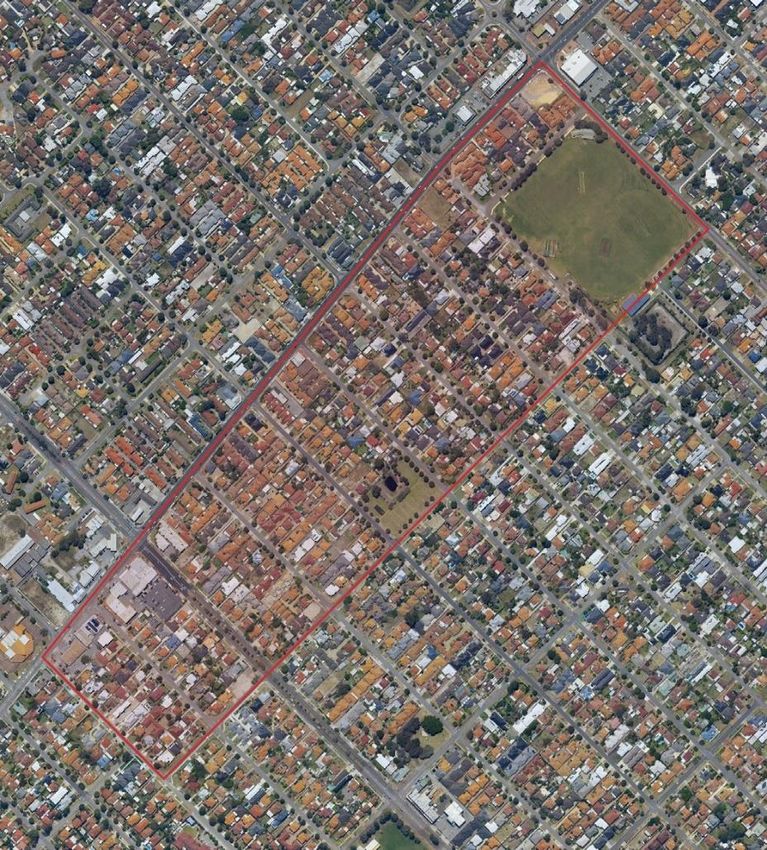
Bedford North Corridor – Transport Impact Review

Due to Bedford’s location in the middle ring of metropolitan suburbs, Bedford is aligned closely to the average household
type across Greater Perth – this requires a diverse range of housing choices to cater not only for larger family
households but also for those in phases where they are living alone or in groups.

In relation to family type, since 2006 there has been a 5% increase in the number of couples with children living in
Bedford – over the same period there has been a decrease in couples without children (-3%) and single parent families
(-2%). A greater proportion of children or young adults living at home as dependents often translates into larger
homes/more bedrooms being required and possibly more outdoor space.

2.4.4    Car Ownership

Car ownership in an area is typically reflective of locational characteristics such as proximity to employment and public
transport.

The suburb of Bedford has a lower percentage of 3+ cars per dwelling (17%) compared to Greater Perth (21%). In line
with the City and Greater Perth trends, between 2006 and 2016, the proportion of households with 0-1 car has
decreased while those households with 2+ cars have grown.

Walter Road West is a high-frequency public transport route, there is an opportunity to try to reduce the amount of car
ownership in Bedford, which will provide health, financial and environmental benefits to households and the community.
Further, the requirement for parking within redeveloped residential lots can be minimized and the spillover to streets and
verges can be reduced – both creating a more attractive and efficient urban area.

Bedford North Corridor – Transport Impact Review

3.       EXISTING SITUATION                                                                                              3.2       Local Context
                                                                                                                         As the Bedford North area evolves to a more urban condition, public transport services will become important for
3.1      Regional Context                                                                                                residents and visitors accessing home or commercial offerings on main street environments.

The Bedford North area (also known as the Walter Road West Precinct) is located in Perth’s inner north-eastern           Bus route 60 and the Circle Route 998/999 run along Walter Road West, providing direct access to Perth CBD and
suburbs, sharing a border with the City of Stirling to the north-west.                                                   Morley Activity Centre to the North-East. Lots closer to public transport are more likely to use public transport. These

Bedford North is well connected with regional roads and buses servicing Morley Activity Centre and central Perth. Rail   lots should be encouraged to have a higher density of development.

connections to Maylands and a future Morley Station offer more attractive travel opportunities.

Walter Road West and Grand Promenade are the main arterial roads servicing the study area. They provide connectivity
to Morley Activity Centre, inner northern suburbs like Inglewood and Mt Lawley, and Perth CBD beyond. The future
Morley Station at Broun Avenue and Tonkin Highway will help with additional connections to Bedford North, as bus
services will be modified to connect to rail, opening up regional connections on the wider public transport network.
Tonkin Highway is close by, providing access to Perth Airport and surrounding employment precincts.

Figure 3 Regional movement network (source: Bedford North Urban Design Study, Hames Sharley, 2021)

                                                                                                                         Figure 4 Lot distance to access public transport services (source: Bedford North Urban Design Study, Hames Sharley, 2021)
Bedford North Corridor – Transport Impact Review

3.3        Location History
The history of the Bedford North location is outlined in the Urban Design Study (Hames Sharley, 2021), which notes
that in the 1950’s the area was ‘edge of the city’ with access via Grand Promenade and Walter Road East – the area
offered the suburban ideal of large blocks with generous house and gardens attracting residents to the area.

Through the 1960’s the Bedford North area saw commercial development begin along the Walter Road West corridor, as
well the establishment of industrial development areas within proximity of the Bedford North area.

From the mid-1990’s infill development has replaced many of the original houses in the precinct – with changing
planning frameworks that have permitted grouped dwellings that follow battleaxe configurations. The Urban Design
Study notes that the suburban qualities of the area are still visible, but that this period of development has impacted
building/street interfaces and tree canopy.

3.4        Existing Land Uses
For the purposes of analysis and comparison the Bedford North study area has been split into seven (7) zones. The
study area zone structure is shown in Figure 5 – with Zone 1 only containing commercial land uses, Zone 2 a small area
of commercial land use and residential dwellings, and Zones 3-7 containing residential dwellings.

Table 2 outlines the breakdown of existing land uses across the Bedford North study area. The study area includes a
total of approximately 497 residential dwellings and approximately 3,443m2 (NLA) of commercial floor area – with the
commercial land uses concentrated along the Walter Road West corridor either side of the intersection with Grand
Promenade.

Table 2 – Bedford North study area existing land uses
 Zone                Residential           Commercial Floor
                   Dwellings (no.)           Area (NLA m2)
       1                   0                       3,342
       2                  29                       202
       3                  40                            0
       4                  68                            0
       5                  168                           0                                                                 Figure 5 Bedford North study area zone structure for analysis of land use data (aerial image source: Nearmaps)
       6                  172                           0
       7                  20                            0
    TOTAL                 497                      3,443
Bedford North Corridor – Transport Impact Review
3.5 Pedestrian Connections The Walk Score walkability assessment tool considers the Bedford North study area to be “somewhat walkable” where
some errands can be accomplished on foot, with a walk score of 66 out of 100. This is a typical walk score for a suburban
The Bedford North study area is located in an inner north-eastern suburb of Perth, with a well-established grid network
location in Perth – with a mix for residential and commercial/light industrial land uses.
of streets. Typical to this type of location the pedestrian network is typically formed by a path network on one side of
residential streets only and on both side of major Local Distributor roads – often residential streets that form a cul-de- The 15-minute walkable catchment from a central location within the study area is shown in Figure 7. This analysis
sac do not have paths on either side of the street. shows that from a central location in the study area, the entire study area is walkable within 15 minutes, as well as the
following locations/land uses:
Figure 6 shows the existing pedestrian network through the study area and the significance of these routes.
• St Peter’s Primary School
• Grand Promenade Reserve/Bedford Bowling Club
• IGA Bedford Supermarket (174 Grand Promenade)
• Walter Road West/Coode Street commercial area (including Morley Police Station)
• Walter Road West/Grand Promenade commercial area (including City Farmers Store)
• Birkett Reserve
• R.A. Cook Reserve
Figure 6 Existing pedestrian connections through the Bedford North study area (aerial image source: Nearmaps) Figure 7 15-minute walking catchment from a central location in the Bedford North study area (source: www.app.TravelTime.com)Bedford North Corridor – Transport Impact Review
Figure 8 shows the 15-minute walkable catchment from an eastern location within the study area. This analysis shows Figure 9 shows the 15-minute walkable catchment from a western location within the study area. This analysis shows
that from an eastern location in the study area, the majority of the study area is walkable within 15 minutes, as well as that from a western location in the study area, the western half of the study area is walkable within 15 minutes, as well
the following locations/land uses: as the following locations/land uses:
• IGA Bedford Supermarket (174 Grand Promenade) • St Peter’s Primary School
• Walter Road West/Coode Street commercial area (including Morley Police Station) • Grand Promenade Reserve/Bedford Bowling Club
• Coventry Village Shopping Centre • IGA Bedford Supermarket (174 Grand Promenade)
• Birkett Reserve • Walter Road West/Grand Promenade commercial area (including City Farmers Store)
• R.A. Cook Reserve • IGA Bedford Supermarket (174 Grand Promenade)
• Rudloc Reserve • Birkett Reserve
• Brown Lake Reserve • Macaulay Park/Walter Road Reserve/Inglewood Stadium
Figure 8 15-minute walking catchment from an eastern location in the Bedford North study area (source: www.app.TravelTime.com) Figure 9 15-minute walking catchment from a western location in the Bedford North study area (source: www.app.TravelTime.com)Bedford North Corridor – Transport Impact Review
3.6 Bicycle Routes The route through the study area identified as a ‘good road riding environment’ along The Strand, is along a typical
residential suburban street for the local area, with a typical 7.0m-7.4m wide carriageway, with unrestricted kerbside on-
3.6.1 Existing Bicycle Network street parking and a speed limit of 50km/h. A view along The Strand is shown in Figure 11.
The Bedford North study area is located within proximity to several lower order existing bicycle routes, with the majority The Strand has priority at its intersection with Clement Street, with both the Clement Street approaches operating under
of these routes running on a northwest to southeast axis. These bicycle routes include: stop sign control. However, at Walter Road West movements from both The Strand approaches are restricted to left in
and left out only, with a central median preventing right turn movements.
• The Strand – identified as a ‘good road rising environment’ running northwest to southeast through the centre
of the study area. Connecting the Midland Line Principal Shared Path (PSP) with Morley Drive Shared Path. Cyclists wishing to remain on The Strand and cross Walter Road West, can do so via the pram ramps and central median
• Perth Bicycle Network (PBN) continuous signed route NE6 – a strategic route running from Maylands Swan island refuge (approximately 1.8m deep) – the northbound crossing is most difficult with no path extension on the
River Foreshore to Reid Highway via the suburbs of Maylands, Inglewood and Dianella. western side of The Strand (south of Walter Road West), preventing cyclists moving off carriageway on the approach to
• Drake Street – identified as a ‘good road rising environment’ running northwest to southeast to the east of the Walter Road West (see Figure 12 right hand side of image). In addition, the northbound crossing is made difficult by the
study area. Connecting Bayswater Town Centre/Midland Line PSP with Morley Drive Shared Path. shallow path deep on the northern side of Walter Road West and the property boundary wall (see Figure 12 left hand
side of image).
Figure 10 shows the existing bicycle routes within vicinity of the Bedford North study area.
Figure 11 View along The Strand (between Walter Road West and Clement Street) identified as a ‘good road riding environment’
(source: Google Streetview)
Figure 12 View along Walter Road West at the intersection with The Strand (identified as a ‘good road riding environment’)
(source: Google Streetview)
Figure 10 Existing bicycle route network (source: Department of Transport – Perth, Fremantle and Stirling Bike Map)Bedford North Corridor – Transport Impact Review
Whilst the Bedford North study area is located within 1km of Morley Activity Centre (to the northeast) and 2km of Mt
Lawley Senior High School and Edith Cowan University Mt Lawley Campus (to the southwest) – there are no existing
clear, safe, identified bicycle routes for those living or working within the study area to travel to these key destinations of
education, employment and retail services.
3.6.2 Future Bicycl e Network
Between 2018-2020 the Department of Transport (DoT) has worked with 33 local governments across Perth and Peel
on the Long Term Cycle Network (LTCN) project. The LTCN project has been a collaboration between State and local
governments to agree on an aspirational network of bicycle routes that link parks, schools, community facilities and
transport services, to make cycling a convenient and viable option for more people and more journeys.
The aim of the project was to develop an aspirational blueprint to ensure State and local governments work together
towards the delivery of one continuous cycling network providing additional transport options, recreational opportunities
and support for tourism and commercial activity.
In June 2020 the City of Bayswater Council endorsed their LTCN – from July 2020 the LTCN is eligible for the City to
seek grant funding support from DoT to deliver bicycle infrastructure along the identified routes – as shown in Figure 13.
Two routes identified in the LTCN are of key importance to the study area in relation to the longer term planning of
movement and access, these are:
• Clement Street – identified as a Local Route connection between the Bedford North study area and Morley
Activity Centre to the northeast and between the study area and Wood Street/Boulton Street to the southwest.
• Catherine Street – parallel to Clement Street and 600m to the south of the study area, is identified as a key
Secondary Route connection between Morley Activity Centre and North Perth via Mt Lawley Senior High School
and Edith Cowan University Mt Lawley Campus.
Both of these LTCN routes would help to address the lack of existing east-west or northeast-southwest bicycle routes in
proximity of the Bedford North study area.
Figure 13 Long Term Cycle Network (source: Department of Transport Long Term Cycle Network project)Bedford North Corridor – Transport Impact Review
3.7 Public Transport Access 3.7.1 Train Services
The Bedford North study area is conveniently located to be accessed by public transport services – these include: The Bedford North study area is not served by direct access to the metropolitan rail network. The nearest train stations
to the study area are Meltham Station (2.5km) with no bus connection from the study area and Bayswater Station
• Bus services – bus routes along Walter Road West, Grand Promenade and Lawrence Street-Barker Street-Coode
(2.9km) with direct bus connections from the study area as set as detailed in the following section.
Street provide bus route connections to the north, east, south and west.
• Bayswater Station services operate towards Perth (12 minute journey time) and Midland (13 minute journey
Figure 14 shows the location of the Bedford North study area in relation to public transport routes.
time):
o Weekday rail services operate between 5.30am and 12 midnight – operating on a 10 minute frequency
during the morning and afternoon peak periods and operating on a 15 minute frequency at other times
(other than after 8pm where services operate on a 30 minute frequency).
o Saturday rail services operate between 5.30am and 12 midnight (there are two late night services on
Friday and Saturday nights that run in the early hours of the morning) – operating on a 15 minute
frequency (other than after 8pm where services operate on a 30 minute frequency).
o Sunday rail services operate between 7am and 12 midnight – operating on a 15 minute frequency (other
than after 8pm where services operate on a 30 minute frequency).
3.7.2 Bus Services
Bus routes along the study areas boundary road of Walter Road West and along Grand Promenade and Lawrence Street-
Barker Street-Coode Street provide bus service connections to the north, east, south and west:
• Bus Route No. 60
o Route 60 operates between Elizabeth Quay Bus Station and Morley Bus Station via William Street,
North Street, Dundas Road and Walter Road West, and provides access to central Perth, Highgate, Mt
Lawley, Inglewood, Bedford and Morley Activity Centre.
o Weekday bus services operate between 6.30am and 12 midnight – operating on a 15 minute frequency
between 7.30am-7.30pm and on a 30-60 minute frequency outside of these times.
o Weekend bus services operate between 8am and 9pm – operating on a 20-30 minute frequency on
Saturdays and a 30 minute frequency on Sundays.
• Bus Route No. 67 and 68
o Route 67 operates between Elizabeth Quay Bus Station and Mirrabooka Bus Station via Beaufort Street,
Grand Promenade, Dianella Drive and Yirrigan Drive, and provides access to central Perth, Highgate, Mt
Lawley, Inglewood, Bedford, Dianella and Mirrabooka.
o Route 68 also operates between Elizabeth Quay Bus Station and Mirrabooka Bus Station via Beaufort
Street, Grand Promenade, Dianella Drive and Yirrigan Drive – however the route travels via Lawrence
Street-Barker Street-Coode Street within proximity of the Bedford North study area. The route also
provides access to central Perth, Highgate, Mt Lawley, Inglewood, Bedford, Dianella and Mirrabooka.
Figure 14 Public transport network in vicinity of the Bedford North study area (source: Transperth)Bedford North Corridor – Transport Impact Review
o Combined weekday bus services operate between 6am and 9pm – operating on a 15-30 minute
frequency until 7pm and on a 60 minute frequency until 9pm.
o Combined weekend bus services operate between 7am and 8pm – operating on a 30 minute frequency
• Bus Route No. 998/999 Circle Route (998 clockwise route / 999 anticlockwise route)
o Routes 998/999 operate as a circular route connecting a range of key transport hubs, activity centres,
and town centres within the inner metropolitan ring of local governments.
o In proximity of the study area the circle route provides access to the east and southeast to Morley
Activity Centre and onto Bayswater Station, via Walter Road West and Coode Street– and to the north
and northwest to Dianella Plaza and onto Stirling Station, via Grand Promenade, Morley Drive, Karrinyup
Road and Cedric Street.
o Weekday bus services operate between 6am and 10pm – operating on a 15 minute frequency and a 30
minute frequency after 8pm.
o Weekend bus services operate between 7am and 7pm – operating on a 15 minute frequency on
Saturdays and a 30 minute frequency on Sundays.
3.8 Local Road Network
The local road network within the Bedford North study area consists of higher order roads along its northern and
Figure 15 Local road hierarchy (source: Main Roads WA)
eastern boundary and supported by a network of lower order residential streets within the study area.
The study area is bound by Walter Road West to the north and Coode Street to the east – both designated as
Distributor A Roads under the Main Roads WA Functional Road Hierarchy.
The study area is bound by Clement Street to the south and Wood Street to the west – both residential streets
designated as Access Roads under the Main Roads WA Functional Road Hierarchy.
In addition, Grand Promenade runs through the study area and is also designated as a Distributor A Road. All other
streets in the study area are residential streets designated as Access Roads under the Main Roads WA Functional Road
Hierarchy as shown in Figure 15.
Walter Road West, Coode Street and Grand Promenade have a posted speed limit of 60km/h – reflecting their role as
higher order Distributor A Roads. While all of the residential streets across the study area have a 50km/h default urban
areas speed limit – reflecting their role as lower order local residential streets. The posted speed limits for the road
network in proximity of the study area is shown in Figure 16.
Figure 16 Speed limits (source: Main Roads WA)Bedford North Corridor – Transport Impact Review
3.8.1 Walter Road West 3.8.2 Grand Promenade
The Walter Road West corridor adjacent to the study area is a Distributor A Road with a 60km/h speed limit and The Grand Promenade corridor adjacent to the study area is a Distributor A Road with a 60km/h speed limit, weekday
existing weekday traffic volumes ranging from 18,500-23,250 vehicles per day (vpd) – 18,500vpd west of Grand traffic volumes from 16,000-23,500vpd – 16,000vpd to the south and 23,500vpd to the north of Walter Road West.
Promenade, 23,250vpd near Drummond Street and 19,500vpd east of Coode Street.
The Grand Promenade corridor is a four lane road (two lanes in each direction), featuring a kerbed median islands and
The Walter Road West corridor is a four lane road (two lanes in each direction), featuring both painted medians and wide planted medians – with the kerbed median used to provide central refuge for pedestrians at key crossing locations
kerbed median islands – with the kerbed median used to provide central refuge for pedestrians at key crossing locations. and the wide planted median used to create right turn pockets at key locations (such as right turn access to the Growers
Market rear car parking area). Figure 19 shows the typical arrangement of Grand Promenade.
The corridor features multiple crossovers into residential properties and into parking areas for commercial properties.
Bus stop infrastructure is located within the footpath, with buses dwelling at bus stops in the nearside traffic lane,
temporarily reducing the travel lane down to one lane.
Figure 17 and Figure 18 show the typical arrangement of Walter Road West.
Figure 19 View northbound along Grand Promenade on approach to the Walter Road West intersection (source: Google Streetview)
3.8.3 Coode Street
The Coode Street corridor adjacent to the study area is a Distributor A Road with a 60km/h speed limit and weekday
traffic volumes from 10,000-11,250vpd – 11,250vpd to the south and 10,000vpd to the north of Walter Road West.
Figure 17 View eastbound along Walter Road West on approach to the Grand Promenade intersection (source: Google Streetview) The Coode Street corridor is a two lane road (one lane in each direction), featuring both painted medians and kerbed
median islands – with the kerbed median used to provide central refuge for pedestrians at key crossing locations. Figure
20 shows the typical arrangement of Grand Promenade.
Figure 18 View eastbound along Walter Road West on approach to the Coode Street intersection (source: Google Streetview)
Figure 20 View northbound along Coode Street on approach to the Walter Road West intersection (source: Google Streetview)Bedford North Corridor – Transport Impact Review
3.8.4 Clement Street 3.9 Existing Vehicular Access Arrangements
The Clement Street corridor runs along the southern boundary of the study area and is an Access Road with a 50km/h Existing vehicular access to the Bedford North study area is provided off Walter Road West, Coode Street and Clement
speed limit – with the weekday traffic volumes along this corridor unknown (neither published by Main Roads or available Street. The vehicle access arrangements are as follows:
from the City’s traffic count data).
Walter Road West
The Clement Street corridor is a two lane street (one lane in each direction), with no median treatments – the street has
a typical residential character featuring multiple crossovers into residential properties. Figure 21 shows the typical • Two traffic signal controlled intersections:
arrangement for Clement Street. o Grand Promenade and Walter Road West (four arm intersection)
o Coode Street and Walter Road West (four arm intersection)
• One restricted access intersection with left in and left out movements only permitted:
o The Strand and Walter Road West (four arm intersection)
• Three stop sign controlled intersections:
o Drummond Street and Walter Road West (t-intersection)
o Birkett Street and Walter Road West (four arm intersection)
o Shaftsbury Avenue and Walter Road West (t-intersection)
• Four give way sign controlled intersections:
o Salisbury Street and Walter Road West (t-intersection)
o Cleveland Street and Walter Road West (t-intersection)
o Roseberry Street and Walter Road West (t-intersection)
Figure 21 View eastbound along Clement Street on approach to the Edward Street intersection (source: Google Streetview) o Lennard Street and Walter Road West (t-intersection)
• Two uncontrolled intersections:
3.8.5 Study Area Residenti al Streets
o Edward Street and Walter Road West (t-intersection)
Figure 22 shows the typical street arrangement for the residential streets within the study area. These are all Access o Lynas Lane and Walter Road West (t-intersection)
Roads with a 50km/h speed limit and feature one lane in each direction, with no median treatments and provide access • Numerous crossovers to residential properties and to parking areas for commercial properties
to multiple residential crossovers. Known weekday traffic volumes range between 700-1,000vpd.
Coode Street
• One traffic signal controlled intersection:
o Walter Road West and Coode Street (four arm intersection)
• Two uncontrolled intersections:
o Barker Street and Coode Street (t-intersection)
o Gummery Street and Coode Street (t-intersection)
• On the eastern side of Coode Street adjacent to the study area there are a number of crossovers to residential
properties and to parking area at the back of Zone Bowling Morley.
Figure 22 View northbound along Shaftesbury Avenue towards Walter Road West (source: Google Streetview)Bedford North Corridor – Transport Impact Review
Clement Street
• One restricted access intersection with left in and left out movements only permitted:
o Grand Promenade and Clement Street (four arm intersection)
• Six stop sign controlled intersections:
o Roseberry Street and Clement Street (four-intersection)
o Drummond Street and Clement Street (four arm intersection)
o Birkett Street and Clement Street (four arm intersection)
o Shaftesbury Avenue and Clement Street (four arm intersection)
o The Strand and Clement Street (four arm intersection)
o Edward Street and Clement Street (four arm intersection)
• One give way sign controlled intersection:
o Salisbury Street and Clement Street (t-intersection)
• Two uncontrolled intersections:
o Lawrence Street and Clement Street (t-intersection)
o Gummery Street and Clement Street (t-intersection)
• Numerous crossovers to residential properties
The existing vehicular access arrangements are shown in Figure 23.
3.10 Existing Car Parking Arrangements
It is outlined in the Urban Design Study for the Bedford North Corridor (Hames Sharley, 2021), that parking provision on
development sites varies across the study area.
It is noted that most grouped dwellings and newer residential developments include double enclosed garages, and older
houses typically feature open carports or in-front at grade parking – this is a reflection of recent design preferences to
place car parking convenience as a priority for house frontages.
It is also noted that replacing more traditional carport / at grade parking spaces with double garages fronting onto the
street has had a large impact on the relationship between buildings and the public realm. It is noted that this impacts the
street character – although it is noted that this can be improved through appropriate design provisions.
Figure 23 Bedford Street study area existing vehicular access arrangements (aerial image source: Nearmaps)Bedford North Corridor – Transport Impact Review
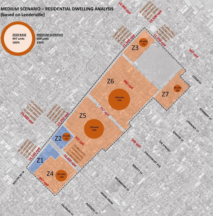
4. ANALYSIS OF TRANSPORT NETWORKS The Hames Sharley Urban Design Study for the Bedford North study area has considered development outcomes from
design tests and made a series of projections about the number of dwellings (or floor space for non-residential uses) that
could occur in the area if modifications to the planning framework were to occur. This information has been utilised to
4.1 Development Scenarios – Residential Dwellings
inform the analysis of the transport networks outlined in this section of the Transport Impact Review report.
For the purposes of analysis and comparison the Bedford North study area has been split into seven (7) zones. The
The residential dwellings development scenarios considered are:
study area zone structure is shown in Figure 24– with Zone 1 only containing commercial land uses, Zone 2 a small area
of commercial land use and residential dwellings, and Zones 3-7 containing residential dwellings. • Low Growth – based on a North Perth development model
• Medium Growth – based on a Leederville development model
• High Growth – based on a Mt Lawley development model
Figure 25 outlines the characteristics of the three development scenarios.
Figure 24 Bedford North study area zone structure for analysis of land use data (aerial image source: Nearmaps) Figure 25 Bedford North study area – development scenarios (source: Bedford North Urban Design Study, Hames Sharley)Bedford North Corridor – Transport Impact Review
Based on the characteristics of the three development scenarios, Table 3 provides a comparison between the number of 4.2 Development Scenario – Commercial Floor Area
dwellings per zone that could be accommodated across the study area in each of the development scenarios.
A single development scenario has been considered in relation to the commercial floor area within the Bedford North
• Existing 2020 – residential dwellings = 497 (baseline) study area.
• Low Growth Scenario – residential dwellings = 524 (+27 dwellings / 5% increase)
In relation to Zone 2 a single development scenario considers the existing minimal commercial floor area (202 NLA m 2)
• Medium Growth Scenario – residential dwellings = 668 (+171 dwellings / 34% increase)
to be retained, alongside the growth in residential dwellings previously outlined in relation to the Low-High growth
• High Growth Scenario – residential dwellings = 738 (+241 dwellings / 48% increase)
scenarios.
Table 3 – Bedford North study area development scenarios – residential dwellings comparison In relation to Zone 1 a single development scenario considers the existing commercial floor area to reduce from
Zone Existing 2020 Residential Low Growth Scenario Medium Growth Scenario High Growth Scenario approximately 3,342 NLA m2 to 2,214 NLA m2, with Zone 1 being supplemented with new residential apartment
Dwellings (no.) Residential Dwellings Residential Dwellings Residential Dwellings
development (145 units).
(no.) (no.) (no.)
1 0 0 0 0 Table 5 outlines the single development scenario in relation to the zones containing commercial floor area.
2 29 31 37 41
Table 5 – Bedford North study area development scenario – commercial floor area
3 40 41 46 50
Zone Existing 2020 Development Scenario Development Scenario
4 68 70 87 95
Commercial Floor Area Commercial Floor Area Residential Apartments
5 168 175 218 238
(NLA m ) 2
(NLA m ) 2
(no.)
6 172 184 246 275
1 3,342 2,214 145
7 20 23 34 39
2 202 202 0
TOTAL 497 524 668 738
3 0 0 0
Table 4 provides additional context in relation to the increases in dwellings from scenario to scenario (i.e. Existing 2020 4 0 0 0
5 0 0 0
to Low / Low to Medium / Medium to High).
6 0 0 0
Table 4 – Bedford North study area development scenarios – residential dwellings comparison scenario to scenario
7 0 0 0
Zone Existing 2020 Residential Existing to Low Growth Low to Medium Growth Medium to High Growth
TOTAL 3,443 2,416 (-1,128) 145 (+145)
Dwellings (no.) Scenario – Residential Scenario – Residential Scenario – Residential
Dwellings (no.) Dwellings (no.) Dwellings (no.)
1 0 0 0 0
2 29 2 6 4
3 40 1 5 4
4 68 2 17 8
5 168 7 43 20
6 172 12 62 29
7 20 3 11 5
Additional Dwellings Added to
27 144 70
Previous Scenario:
% Increase from Existing 2020
5% 34% 48%
Baseline:You can also read