Appropriate Assessment Screening for the Rural Waterford Visitor Experience Development Plan 2021- 2023
←
→
Page content transcription
If your browser does not render page correctly, please read the page content below
Appropriate Assessment Screening
for the Rural Waterford Visitor
Experience Development Plan 2021-
2023

   April 2021

  © 2021 KPMG, an Irish partnership and a member firm of the KPMG global organization of independent member firms affiliated wi th KPMG
                         International Limited, a private English company limited by guarantee. All rights reserved.

                                             Document classification: KPMG Confidential
Error! Reference
source not found.

Document review and approval
Revision history
 Version    Author                  Date                   Revision
 1          Shane McCormack         26/04/21

This document has been reviewed by
           Reviewer                                                   Date reviewed
 1         Richard Hamilton                                           30/4/21
 2
 3
 4
 5

This document has been approved by
           Subject matter experts
           Name                                Signature              Date reviewed
 1         Richard Hamilton                                           30/4/21
 2
 3
 4
 5

Contents
1          Introduction                                                               1
1.1        Background to the Visitor Experience Development Plan                       1

2          Background to the Appropriate Assessment                                   2

3          Stages of the Appropriate Assessment                                       4

4          Screening Stage Assessment                                                 6
4.1        Description of the Proposed Plan                                            6
4.1.1           Location                                                               6
4.1.2           Development Proposal                                                   6
4.1.3           Vision Statement                                                       9
4.2        Biodiversity of the Waterford Area                                          9
4.2.1           Special Areas of Conservation                                          9
4.2.2           Special Protection Areas                                              13

                                                                                       i
Error! Reference
source not found.
4.3 Identification of Natura 2000 sites/Species Potentially Affected 15
4.4 In Combination effects 44
5 Conclusions 47
5.1 Data used for the AA screening Assessment 47
iiError! Reference
source not found.
1 Introduction
An Appropriate Assessment (AA) is an assessment of the potential effects of a proposed
project or plan, on its own, or in combination with other plans or projects, on one or more
NATURA 2000 sites (Special Areas of Conservation (SAC) or Special Protection Areas
(SPA)). The following Appropriate Assessment (Screening Stage) has been prepared by
KPMG Future Analytics. The proposed plan relates to the Appropriate Assessment
Screening for the Rural Waterford Visitor Experience Development Plan 2021-2023.
1.1 Background to the Visitor Experience Development Plan
The Visitor Experience Development Plan (VEDP) has been established to encourage
and support growth and economic development within rural Waterford. The focus of this
plan is on those rural areas outside of the key urban centres of Waterford City,
Dungarvan and Tramore; the less visited places that in themselves encapsulate much of
the essence of the county. This development plan will:
❖ seek to conserve, enhance, and interpret the natural, built, and cultural
environment of the area,
❖ provide a range of enhanced recreational opportunities and experiences for local
people and visitors,
❖ provide a range of opportunities for a high quality and authentic experience for
visitors to the area,
❖ generate local economic benefit, contributing to sustainable rural regeneration,
❖ raise the profile of the study area as a premier outdoor activity destination, and
❖ facilitate understanding, appreciation, and protection of the natural environment.
The new three-year strategic development plan is intended to guide development of rural
Waterford and support the development of existing and new visitor experiences and
encourage more visitors to stay in the area.
The AA Screening stage examines the likely significant effects of a plan or project, either
on its own, or in combination with other plans and projects, upon a Natura 2000 site and
considers whether, on the basis of objective scientific evidence, it can be concluded, in
view of best scientific knowledge and the conservation objectives of the relevant
European sites, that there are not likely to be significant effects on any European site.
1Error! Reference
source not found.
2 Background to the Appropriate Assessment
The Habitats Directive 92/43/EEC (together with the Birds Directive (2009/1477/EC))
forms the cornerstone of Europe's nature conservation policy. The Directive protects
over 1000 animals and plant species and over 200 "habitat types" which are of European
importance. In the Directive, Articles 3 to 9 provide the legislative means to protect
habitats and species of European Community interest through the establishment and
conservation of an EU-wide network of conservation sites (NATURA, 2000). These are
Special Areas of Conservation (SACs) designated under the Habitats Directive and
Special Protection Areas (SPAs) designated under the Birds Directive), Article 6(3) and
6(4) of the Habitats Directive set out the decision-making tests for plans and projects
likely to affect NATURA 2000 sites (Annex 1.1). Article 6(3) establishes the requirement
for Appropriate Assessment:
"Any plan or project not directly connected with or necessary to the management
of the [NATURA 2000] site but likely to have a significant effect thereon, either
individually or in combination with other plans and projects, shall be subjected to
appropriate assessment of its implications for the site in view of the site's
conservation objectives. In light of the conclusions of the assessment of the
implication for the site and subject to the provisions of paragraph 4, the component
national authorities shall agree to the plan or project only after having ascertained
that it will not adversely affect the integrity of the site concerned and, if appropriate,
after having obtained the opinion of the general public."
As outlined in “Managing Natura 2000 sites The provisions of Article 6 of the 'Habitats'
Directive 92/43/EEC” (European Commission, 21 November 2018) “The purpose of the
appropriate assessment is to assess the implications of the plan or project in respect of
the site’s conservation objectives, either individually or in combination with other
plans or projects. The conclusions should enable the competent authorities to ascertain
whether the plan or project will adversely affect the integrity of the site concerned. The
focus of the appropriate assessment is therefore specifically on the species and/or the
habitats for which the Natura 2000 site is designated.”
As outlined in the EC guidance document on Article 6(4) (January 2007)1:
“Appropriate assessments of the implications of the plan or project for the site
concerned must precede its approval and take into account the cumulative effects
which result from the combination of that plan or project with other plans or projects
in view of the site's conservation objectives. This implies that all aspects of the plan
or project which can, either individually or in combination with other plans or
projects, affect those objectives must be identified in the light of the best scientific
knowledge in the field.
Assessment procedures of plans or projects likely to affect NATURA 2000 sites should
guarantee full consideration of all elements contributing to the site integrity and to the
overall coherence of the network, both in the definition of the baseline conditions and in
1
European Commission. (2007).Guidance document on Article 6(4) of the 'Habitats Directive' 92/43/EEC –
Clarification of the concepts of: alternative solutions, imperative reasons of overriding public interest,
compensatory measures, overall coherence, opinion of the commission;
2Error! Reference
source not found.
the stages leading to identification of potential impacts, mitigation measures and residual
impacts. These determine what has to be compensated, both in quality and quantity.
Regardless of whether the provisions of Article 6(3) are delivered following existing
environmental impact assessment procedures or other specific methods, it must be
ensured that:
• Article 6(3) assessment results allow full traceability of the decisions eventually
made, including the selection of alternatives and any imperative reasons of
overriding public interest.
• The assessment should include all elements contributing to the site’s integrity
and to the overall coherence of the network as defined in the site’s
conservation objectives and Standard Data Form, and be based on best
available scientific knowledge in the field. The information required should be
updated and could include the following issues:
o Structure and function, and the respective role of the site’s ecological assets;
o Area, representativity and conservation status of the priority and nonpriority
habitats in the site;
o Population size, degree of isolation, ecotype, genetic pool, age class structure,
and conservation status of species under Annex II of the Habitats Directive or
Annex I of the Birds Directive present in the site;
o Role of the site within the biographical region and in the coherence of the
NATURA 2000 network; and,
o Any other ecological assets and functions identified in the site.
• It should include a comprehensive identification of all the potential impacts
of the plan or project likely to be significant on the site, taking into account
cumulative impacts and other impacts likely to arise as a result of the
combined action of the plan or project under assessment and other plans
or projects.
• The assessment under Article 6(3) applies the best available techniques
and methods, to estimate the extent of the effects of the plan or project on
the biological integrity of the site(s) likely to be damaged.
• The assessment provides for the incorporation of the most effective
mitigation measures into the plan or project concerned, in order to avoid,
reduce or even cancel the negative impacts on the site.
• The characterisation of the biological integrity and the impact assessment
should be based on the best possible indicators specific to the NATURA
2000 assets which must also be useful to monitor the plan or project
implementation.”
3Error! Reference
source not found.
3 Stages of the Appropriate Assessment
This Appropriate Assessment screening was undertaken in accordance with the
European Commission Methodological Guidance on the provision of Article 6(3) and 6(4)
of the 'Habitats' Directive 92/43/EEC (EC, 2001), Part XAB of the Planning and
Development Act 2000, as amended, in addition to the December 2009 publication from
the Department of Environment, Heritage and Local Government; ‘Appropriate
Assessment of Plans and Projects in Ireland: Guidance for Planning Authorities’ and the
European Communities (Birds and Natural Habitats) Regulations 2011.
In order to comply with the above Guidelines and legislation, the Appropriate
Assessment process must be structured as follows:
1) Screening stage:
• Description of plan or project, and local site or plan area characteristics;
• Identification of relevant Natura 2000 sites, and compilation of information on
their qualifying interests and conservation objectives
• Assessment of likely effects – direct, indirect and cumulative- undertaken on
the basis of available information as a desk study or field survey or primary
research as necessary and,
• Screening Statement with Conclusions.
2) Appropriate Assessment (Natura Impact Statement):
• Description of the NATURA 2000 sites that will be considered further;
• Identification and description of potential adverse impacts on the
conservation objectives of these sites likely to occur from the project or plan;
and,
• Mitigation Measures that will be implemented to avoid, reduce or remedy any
such potential adverse impacts
• Assessment as to whether, following the implementation of the proposed
mitigation measures, it can be concluded, beyond all reasonable scientific
doubt, that there will be no adverse impact on the integrity of the relevant
European Site in light of its conservation objectives"
• Conclusions.
3) Alternative Solutions
If mitigation is possible that enables a risk to be avoided fully, then, subject to other
necessary approvals, the project or plan may proceed. If mitigation measures are
insufficient, or are not actually practicable and achievable to avoid the risk entirely, then,
in the light of a negative assessment, the plan or project may not proceed. A wider
search for alternative solutions may need to be considered – Stage 3. 2
2
(DoEHLG, 2009) Appropriate Assessment of Plans and projects in Ireland: Guidance for planning
authorities.
4Error! Reference
source not found.
4) Imperative Reasons of Overriding Public Interest (IROPI)/Derogation.
Stage 4 is the main derogation process of Article 6(4) which examines whether there are
imperative reasons of overriding public interest (IROPI) for allowing a plan or project that
will have adverse effects on the integrity of a NATURA 2000 site to proceed in cases
where it has been established that no less damaging alternative solution exists. The extra
protection measures for Annex I priority habitats come into effect when making the IROPI
case.
5Error! Reference
source not found.
4 Screening Stage Assessment
4.1 Description of the Proposed Plan
4.1.1 Location
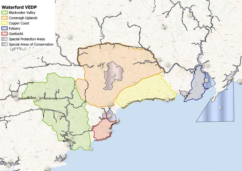
The Rural Waterford Visitor Experience study area spans across County Waterford as
illustrated on Figure 4-1. This area of Ireland is a vibrant tourism destination within
Irelands Ancient East. The focus of this VEDP is upon the rural areas of the county,
specifically the five clusters which include the Waterford Estuary, Copper Coast,
Comeragh Uplands, Gaeltacht na nDéise, and the Blackwater Valley. Each of these
areas contains communities whose characters and traditions have evolved from the
landscape within which they are situated, creating a sense of place unique to the rural
areas of Waterford.
Figure 4-1: Waterford Study Area
4.1.2 Development Proposal
The VEDP proposes to enable rural Waterford communities to create and promote
coherent visitor experiences. Successful implementation of this plan will see increased
numbers of visitors (both international and domestic), staying for longer and spending
more in local communities. Tourist attractions along with Greenway, Blueway and
additional trail networks will be created and enhanced, connecting each of the five
destination clusters. This proposal will potentially increase footfall within County
6Error! Reference
source not found.
Waterford as domestic and visitor numbers are projected to increase. Table 4-1 outlines
the overall actions which are aimed at maximising destination potential and highlight
potential proposed developments within the VEDP.
Table 4-1
Action
Work with Fáilte Ireland to implement a rural Waterford Experience Industry
Development Programme approach for high potential experiences and provide
1.1 experience development support.
Develop project proposal concepts for visitor attractions across the different
rural areas.
— Feasibility assessment of enhanced visitor experiences at the Copper
Coast Geopark Visitor Centre that includes activity based and/or virtual
reality access to the underground mine experience at the Tankardstown
site and development of coastal path connectivity along the Copper
Coast stretch.
— Feasibility assessment of biodiversity and activity tourism experiences
along with enhanced visitor facilities to the Comeragh Uplands
attractions.
— Feasibility assessment of Waterford Estuary maritime and early human
settlement heritage as interpretive visitor experiences and attractions.
— Support the ongoing development of a Blackwater Blueway as an on
and off water activity route along the Blackwater River. This would
provide information for water and land-based activities, and through
engaging interpretation tell the story of the industrial heritage of the river
1.2 and its conservation importance.
Support RRDF application for new Gaeltacht multi-purpose tourism, 'Áras na
nDéise’, an enterprise and cultural facility to include exhibition, theatre space
with 150-seat performance venue, café, multi-purpose rooms including
educational space for delivery of courses/training as well as cultural activities,
digital hub/co-working space, craft and food outlet and 20-bed visitor hostel to
1.3 Fáilte Ireland standard.
Review infrastructural requirements and gaps for visitors travelling via bus, rail,
car, bicycle, boat/ yacht, or with caravans, including lay-bys/ passing bays,
interpretation sites, parking and charging, locations to stay over-night WCCC
2021 Infrastructural requirements analysis undertaken34 (camping/
caravan/campervan sites), beach facilities, and storage facilities for canoes
1.4 and bicycles.
1.5 Consider a wayfinding strategy for the five rural Waterford areas. This to
include a review of orientation, directional and interpretative signage provision
7Error! Reference
source not found.
and effectiveness with a focus on a tiered approach and the ease of visitors to
navigate the county.
Undertake an audit of current food experiences to identify year-round saleable
rural food experiences with growth potential. For example, targeting
1.6 development of a visitor experience at producers.
Develop a Rural Waterford Food Trail route linking year-round food
experiences across county and showcase artisan produce. Consider themed
1.7 elements of a food trail such as a Waterford Whiskey Trail.
Support development of a coastal corridor as part of a collaborative initiative
with Co. Wexford, to include the coast and potential Blackwater Blueway
separately, and as part of a collaborative initiative with County Wexford to
include:
— Enhancing the existing marine recreation facilities and develop
additional water access resources:
— Linking marine trails and land trails and heritage sites at the trailhead
and in adjacent areas and promote their use;
— Animating local and visitor participation through club supports, activity
programmes and events;
1.8 — Supporting outdoor recreation activity providers and services.
Support further development of the Waterford Greenway to include planned
links to the county border with Cork, links to Lismore, links to County Tipperary
via Kilmeaden as proposed in the Munster Vales Tourism Development
1.9 Strategy, and to Waterford City Centre.
Promote and support on-going development of trails linking the five rural
destination clusters and on specific themes of Heritage Waterford, Gardens
1.10 Waterford, Cycle Waterford, Walk Waterford.
Create workshops for visitors to learn the Irish language, including experiences
that integrate the language with music, arts, crafts, and photography courses
1.11 and promote off-season
Support appropriate development of coastal and riverside walks to include:
— Waterford City to Estuary connectivity
— Estuary Cliff Path extension to Tramore
1.12 — Tramore to Dungarvan connectivity along the Copper Coast
8Error! Reference
source not found.
— Dungarvan to Blackwater Valley connectivity to include Gaeltacht and
Ardmore as route options
4.1.3 Vision Statement
The Rural Waterford Visitor Experience strategy identifies the area as a destination with
strong natural and cultural heritage, are the recreational opportunities provided by the
mountain ranges, the rivers and coast. The strategy highlights the opportunity to combine
tourist activities, particularly walking and cycling, with visits to towns and villages as well
as a wide range of built heritage sites within the area. This has led to the adoption of the
Rural Waterford Visitor Experience vision statement as outlined below,
“Enhancement and promotion of compelling rural Waterford visitor experiences in
each character area will deliver memorable and inspirational moments, inspiring
visitors to not only share their exceptional experience with others but to return, with
positive impacts for both local communities and businesses”.
4.2 Biodiversity of the Waterford Area
Data from the National Parks and Wildlife Service (NPWS) shows that this area contains
many protected species and habitats. The NPWS provides information on SAC3 and
SPA4 sites within the Waterford study area.
4.2.1 Special Areas of Conservation
Hook Head SAC
This SAC comprises of marine subtidal reefs, sea cliffs and is an important habitat for
many species. The peninsula forms the eastern side of Waterford Harbour, while to the
east it adjoins the estuary mouth of Bannow Bay. Hook Head is composed of
Carboniferous Limestone and Old Red Sandstone and is paleontologically of
international importance. This site is of conservation importance for its subtidal reef and
shallow bay communities, and their diversity of species, as well as for the vegetated sea
cliffs. These habitats are listed under the E.U. Habitats Directive. The rocky coastline is
also important for a number of breeding birds, two of which are listed on Annex I of the
E.U. Birds Directive.
Nier Valley Woodlands SAC
Nier Valley Woodlands comprises an area of mixed semi-natural deciduous forest lying
on the flanks of the Nier Valley. It comprises of numerous separate areas of woodland
which were once joined up but have now been separated due to human intervention.
Two Red Data Book vertebrates - Badger and Natterer’s Bat - are present in the
woodlands. Other animal species recorded from the site include Fallow Deer, Red
Squirrel, Stoat, Long-Eared Owl, Woodcock and Pheasant. This site is of significant
conservation status because of the presence of old oak woodland. It is of additional
3
https://www.npws.ie/protected-sites/sac
4
https://www.npws.ie/protected-sites/spa
9Error! Reference
source not found.
ecological and educational interest as it contains areas that show the stages of
development from open heath to mature Oak woodland.
Helvick Head SAC
Helvick Head is situated on the southern side of Dungarvan Harbour in Co. Waterford.
This Old Red Sandstone ridge extends as far west as Cork City and in some areas rises
to 60m. This SAC comprises sea cliffs, cliff top vegetation and an area of marine waters
off Helvick Head. The site is of significant conservation importance, as it includes good
examples of coastal dry heath and vegetated sea cliffs, both habitats that are listed on
Annex I of the E.U. Habitats Directive. It is also of high ornithological importance, with
one seabird species having a population of national importance. The presence of
breeding Peregrine and Chough is also of note.
Ardmore Head SAC
Ardmore Head is situated to the east of the village of Ardmore on the Waterford coastline.
The site consists of sea cliffs and associated coastal habitats which support many
breeding seabirds. The cliffs face towards the east and south, but there is a small section
facing north. This site is of conservation value as it displays good examples of the type
of sea cliff and dry heath characteristic of the south coast. Both of these habitats are
listed on Annex I of the E.U. Habitats Directive. The breeding seabirds and Chough add
to the ecological interest.
Great Island Channel SAC
The Great Island Channel stretches from Little Island to Midleton, with its southern
boundary being formed by Great Island. This SAC overlaps with the Cork Harbour SPA
and has an area of 1,443.22 ha. This important area of biodiversity contains several other
sites of conservation interest. Geologically, Cork Harbour consists of two large areas of
open water in a limestone basin, separated from each other and the open sea by ridges
of Old Red Sandstone. Within the site is the estuary of the Dungourney and
Owennacurra Rivers. These rivers, which flow through Midleton, provide the main source
of freshwater to the North Channel. The site is of major importance for the two habitats
listed on Annex I of the E.U. Habitats Directive, as well as for its important numbers of
wintering waders and wildfowl. It also supports a good invertebrate fauna.
Bannow Bay SAC
Bannow Bay stretches approximately 14 km along the south coast of Co. Wexford. Small
rivers and streams to the north and south-west flow into the bay and their sub-estuaries
from part of the site. The bay contains large areas of mud and sand and is of considerable
conservation significance for the large number of E.U. Habitats Directive Annex I habitats
that it contains, including the priority habitat fixed grey dune. The legally protected and
Red Data Book plant species Perennial Glasswort also can be found within this SAC.
The site is also an SPA because of the important numbers of wintering wildfowl it
supports, including an internationally important population of Light-bellied Brent Goose.
Tramore Dunes and Backstrand SAC
The Tramore Dunes and Backstrand are situated at the head of Tramore Bay, east of
Tramore town in Co. Waterford. The Tramore dunes (Burrow) are the result of a classic
inshore process - the growth of a spit of shingle and sand across a shallow bay. Behind
the spit lies the Back Strand which dries out at low tide and is connected to the open sea
10Error! Reference
source not found.
by narrows at Rinneshark. This SAC site is of major ecological importance for the range
of good quality coastal habitats which occur, including fixed dunes, which are listed as a
priority habitat on Annex I of the E.U. Habitats Directive. The site has a remarkably rich
flora, featuring a number of rare and protected species, and the intertidal area is
important for wintering waterfowl.
Ballymacoda (Clonpriest and Pillmore) SAC
The Ballymacoda SAC lies within close proximity of Youghal, Co. Cork. The site is of
high conservation importance because numerous habitats present are listed on Annex I
of the E.U. Habitats Directive. Ballymacoda is an most important bird site within the
region and supports a higher number of waders than any other Co. Cork estuary of its
size. It also contains important numbers of Golden Plover and Bar-tailed Godwit, two
E.U. Birds Directive Annex I species, an internationally important population of Black-
tailed Godwit, and nationally important numbers of a further 13 bird species.
Blackwater River (Cork/Waterford) SAC
The Blackwater River is one of the largest rivers in Ireland which spans across many
counties. This SAC is of considerable conservation significance for the occurrence of
good examples of habitats and populations of plant and animal species that are listed on
Annexes I and II of the E.U. Habitats Directive respectively. Additionally, it is of high
conservation value for the populations of bird species that use it. Two Special Protection
Areas, designated under the E.U. Birds Directive, are also located within the site -
Blackwater Callows and Blackwater Estuary. The importance of the site is enhanced by
the presence of a suite of uncommon plant species.
River Barrow And River Nore SAC
The River Barrow and River Nore transverse through eight counties throughout Munster
and Leinster. This SAC consists of the freshwater stretches of the Barrow and Nore River
catchments as far upstream as the Slieve Bloom Mountains, and it also includes the tidal
elements and estuary as far downstream as Creadun Head in Waterford. The site is of
considerable conservation significance for the occurrence of good examples of habitats
and of populations of plant and animal species that are listed on Annexes I and II of the
E.U. Habitats Directive. Additionally, it is of high conservation value for the populations
of bird species that use it. The occurrence of several Red Data Book plant species
including three rare plants in the salt meadows and the population of the hard water form
of the Freshwater Pearl Mussel, which is limited to a 10 km stretch of the Nore, add
further interest to this site.
Glendine Wood SAC
This SAC lies within close proximity of Dungarvan, Co. Waterford and consists of a steep-
sided, narrow ravine cut through a low ridge of Old Red Sandstone by the Glendine
River. Woodland covers the valley sides and the land to the east and west of the mouth
of the ravine. The woodland supports a population of badgers, a Red Data Book species.
Dipper, a bird associated with clean, fast flowing rivers, also occurs within the site. The
rare and Annex II listed species Killarney Fern is found at this site.
Hugginstown Fen SAC
Hugginstown Fen is situated roughly 4 km south-west of Ballyhale, Co. Kilkenny. The
site consists of a relatively large, isolated area of swamp and floating fen developed in a
11Error! Reference
source not found.
small valley in hilly country. The site comprises of Limestone and Old Red Sandstone.
Two uncommon insect species recorded from Hugginstown Fen are the Scarce Emerald
Damselfly and the Hoverfly. The Common Frog, a Red Data Book species, is frequent
at the site.
Moanour Mountain SAC
The Moanour Mountain is located approximately 7 km south-west of Tipperary town.At
its peak this mountain reaches a height of 335 m. The site represents probably the only
part of this mountainous ridge that retains semi-natural vegetation, the remainder having
been afforested in recent times. This small scale site is of particular conservation
importance for the presence of wet heath and dry heath, both good examples of E.U.
Habitats Directive Annex I habitats.
Comeragh Mountains SAC
The Comeragh Mountains are located south-west of Carrickon-Suir in Co. Waterford.
These mountains consist of Old Red Sandstone and has formulated by glaciation. This
site has numerous important biodiversity habitats, including blanket bog, heath, upland
grassland, scree, exposed rock, lakes and streams. The blanket bog represents the
south-eastern extremity of the range of this habitat type in Ireland. There are many
corries, most of which have associated oligotrophic lakes. Overall, this site is of
considerable conservation importance.
Ballyteige Burrow SAC
The Ballyteige Burrow is located along the coast in Co. Wexford. This coastal site is of
major ecological value for its range of good quality coastal habitats, including three
habitats given priority status on Annex I of the E.U. Habitats Directive - fixed dune, dune
heath and lagoon. The dune system is of excellent quality, physically well developed and
with a rich flora which includes five protected species. The importance of the site for
wintering waterfowl further enhances its value.
Galtee Mountains SAC
The Galtee Mountains are located in east Limerick and south Tipperary. At its highest
point this mountain ranges 920m in height. The rare species Small-white Orchid,
Northern Rock cress and Alpine Saw-wort have been recorded from the site. These
species are included in the Red Data Book and the first two are legally protected under
the Flora (Protection) Order, 2015. The site supports breeding Peregrine, a species listed
on Annex I of the E.U. Birds Directive. This site is of high conservation value due to the
fact that it contains a range of important upland habitats in a relatively isolated inland
mountain site. Eight of these habitats are listed in Annex I of the E.U. Habitats Directive,
and two of those have priority status. The presence of a number of rare, scarce and
uncommon plant species adds greatly to the significance of the SAC.
Lower River Suir SAC
Lower River Suir SAC is located within the counties of Tipperary, Kilkenny and
Waterford. This freshwater river contains excellent examples of a number of Annex I
habitats, including the priority habitats alluvial forest and Yew woodland. The site also
supports populations of several important animals species, some listed on Annex II of
the Habitats Directive or listed in the Irish Red Data Book. The presence of two legally
12Error! Reference
source not found.
protected plants and the ornithological importance of the site adds further to the
ecological interest and importance.
4.2.2 Special Protection Areas
Blackwater Estuary SPA
The Blackwater Estuary SPA extends from Youghal New Bridge to the Ferry Point
peninsula, close to where the river enters the sea. This site comprises a section of the
main channel of the River Blackwater to Ballynaclash Quay. The Blackwater Estuary
SPA is an internationally important wetland site on account of the population of Black-
tailed Godwit it supports. It is also of high importance in a national context, with seven
species having populations which exceed the thresholds for national importance. The
occurrence of Little Egret, Golden Plover and Bar-tailed Godwit is of particular note as
these species are listed on Annex I of the E.U. Birds Directive. The Blackwater Estuary
is also a Ramsar Convention site.
Tramore Back Strand SPA
This SPA is located approximately 2 km east of Tramore town in County Waterford.
Tramore Back Strand SPA is of great importance for wintering waterfowl, with one
species occurring in internationally important numbers and a further seven species
having populations of national importance. The regular occurrence of Little Egret, Golden
Plover and Bar-tailed Godwit is of particular note as these three species are listed on
Annex I of the E.U. Birds Directive. Tramore Back Strand is also a Ramsar Convention
site.
Ballymacoda Bay SPA
The Ballymocoda Bay SPA extends north-east from Ballymacoda to within close
proximity of Youghal. It comprises the estuary of the Womanagh River, a substantial river
which drains a large agricultural catchment. Wintering waterfowl are found on site and
this SPA acts as an important habitat. The site is recognised internationally due to the
high levels of wintering birds but also for its Golden Plover and Black-tailed Godwit
populations. In addition, it supports nationally important populations of a further fourteen
species. Two of the species which occur, Golden Plover and Bartailed Godwit, are listed
on Annex I of the E.U. Birds Directive. Ballymacoda Bay is also a Ramsar Convention
site.
Ballycotton Bay SPA
Situated on the south coast of Co. Cork, this site comprises two sheltered inlets which
receive the flows of several small rivers. This small SPA supports an excellent diversity
of wintering waterbirds and has nationally important populations of eleven species, of
which two, Golden Plover and Bar-tailed Godwit, are listed on Annex I of the E.U. Birds
Directive. Ballycotton Bay is also a Ramsar Convention site and part of the Ballycotton
Bay SPA is a Wildfowl Sanctuary.
Blackwater Callows SPA
The Blackwater Callows SPA comprises the stretch of the River Blackwater that runs in
a west to east direction between Fermoy and Lismore in Counties Cork and Waterford,
a distance of almost 25 km. The Blackwater Callows SPA is of importance for its
13Error! Reference
source not found.
populations of wintering waterfowl, including an internationally important population of
Whooper Swan and nationally important populations of Wigeon, Teal and Black-tailed
Godwit. The presence of Whooper Swan, as well as Little Egret, is of particular note as
these species are listed on Annex I of the E.U. Birds Directive. Part of the Blackwater
Callows SPA is a Wildfowl Sanctuary.
Bannow Bay SPA
Bannow Bay is a situated on the south coast of Co. Wexford and stretches up to 14 km
long. A number of rivers flow into the site, the primary being the Owenduff and the Corock
which enter at the top end of the estuary. Bannow Bay SPA supports internationally
important populations of Light-bellied Brent Goose and Black-tailed Godwit as well as
nationally important populations of a further eleven species. Two of the species that
occur, i.e. Golden Plover and Bar-tailed Godwit, are listed on Annex I of the E.U. Birds
Directive. Bannow Bay is a Ramsar Convention site and part of Bannow Bay SPA is a
Wildfowl Sanctuary.
Cork Harbour SPA
Cork Harbour SPA is an important area of biodiversity for its bird population. This SPA
supports nationally important wintering populations of 22 species, as well as a nationally
important breeding colony of Common Tern. Several of the species which occur regularly
are listed on Annex I of the E.U. Birds Directive, i.e. Whooper Swan, Little Egret, Golden
Plover, Bar-tailed Godwit, Ruff, Mediterranean Gull and Common Tern. The site provides
both feeding and roosting sites for the various bird species that use it. Cork Harbour is
also a Ramsar Convention site and part of Cork Harbour SPA is a Wildfowl Sanctuary.
Mid-Waterford Coast SPA
The Mid-Waterford Coast SPA covers the areas of high coast and sea cliffs in Co.
Waterford between Newtown Cove to the east and Ballyvoyle to the west. The site
includes the sea cliffs and the land adjacent to the cliff edge. The Mid-Waterford Coast
SPA is an important site for Chough and Peregrine, both species that are listed on Annex
I of the E.U. Birds Directive. It also supports a range of breeding seabirds, including
nationally important populations of Cormorant and Herring Gull.
Helvick Head to Ballyquin SPA
Helvick Head to Ballyquin SPA is situated on the south-west coast of Co. Waterford. It
includes the sea cliffs and land adjacent to the cliff edge between Helvick Head in the
east and Ballyquin townland in the south-west. The Helvick Head to Ballyquin SPA is an
important site for Chough and Peregrine, both species that are listed on Annex I of the
E.U. Birds Directive. It also supports a range of breeding seabirds, including populations
of Cormorant, Herring Gull and Kittiwake of national importance.
Keeragh Islands SPA
The Keeragh Islands are two low-lying islets located just over 1 km offshore from the
south Wexford coastline. The site includes the islets and associated rocky shorelines
and reefs, as well as the surrounding marine area to a distance of 200 m. The islets,
which rise to a maximum height of about 10 m above sea level, have a small area of land
permanently above the tide line. The vegetation is predominantly maritime in character,
with species such as Red Fescue, Thrift, Common Scurvygrass and Sea Campion
occurring. The surrounding reefs support a range of seaweeds. The Keeragh Islands
14Error! Reference
source not found.
SPA is of particular importance for its nationally important population of breeding
Cormorant. It retains potential for attracting breeding terns, species that are listed on
Annex I of the E.U. Birds Directive.
Dungarvan Harbour SPA
Dungarvan Harbour SPA is located in south-west Co. Waterford and lies at the eastern
end of the former valley of the River Blackwater - this river now turns south at Cappoquin,
vacating its original course. The site is of high conservation importance, for supporting
internationally important populations of Light-bellied Brent Goose and Black-tailed
Godwit and because it regularly supports in excess of 20,000 wintering waterbirds. In
addition, it holds nationally important populations of a further thirteen species, including
Golden Plover and Bar-tailed Godwit, two species that are listed on Annex I of the E.U.
Birds Directive. Dungarvan Harbour is a Ramsar Convention site.
4.3 Identification of Natura 2000 sites/Species Potentially Affected
The following Appropriate Assessment Screening examines the likely significant effects
of the masterplan on its own and in combination with other plans and projects, upon a
Natura 2000 sites and considers whether, on the basis of objective scientific evidence, it
can be concluded, in view of best scientific knowledge and the conservation objectives
of the relevant European sites, that there are not likely to be significant effects on any
European site. Table 4-2 and 4-3 list the SAC and SPA sites which will be screened
accordingly. Table 4-4 provides initial screening of SAC sites and Table 4-5 displays an
initial screening of SPA sites.
Figure 4.2 outlines SPA, Proposed Natural Heritage Areas, Natural Heritage Areas and
SAC’s within the Waterford study area. The screening outlines that no significant effects
are likely to happen.
Table 4-2:SAC sites within the Waterford study area
Special Areas of Conservation
Site Code Name County
000764 Hook Head SAC Wexford
000668 Nier Valley Woodlands SAC Waterford
000665 Helvick Head SAC Waterford
002123 Ardmore Head SAC Waterford
001058 Great Island Channel SAC Waterford
000697 Bannow Bay SAC Wexford
000671 Tramore Dunes and Backstrand SAC Waterford
000077 Ballymacoda (Clonpriest and Pillmore) SAC Cork
002170 Blackwater River (Cork/Waterford) SAC Cork/ Waterford
004233 River Barrow And River Nore SAC Kilkenny/ Laois
002324 Glendine Wood SAC Waterford
000404 Hugginstown Fen SAC Kilkenny
002257 Moanour Mountain SAC Tipperary
001952 Comeragh Mountains SAC Waterford
000696 Ballyteige Burrow SAC Wexford
000646 Galtee Mountains SAC Limerick/ Tipperary
15Error! Reference
source not found.
002137 Lower River Suir SAC Kilkenny/ Tipperary/
Waterford
Table 4-3: SPA sites within the Waterford study area
Special Protection Areas
Site Code Name County
004028 Blackwater Estuary SPA Cork/ Waterford
004027 Tramore Back Strand SPA Waterford
004023 Ballymacoda Bay SPA Cork
004022 Ballycotton Bay SPA Cork
004094 Blackwater Callows SPA Cork/ Waterford
004033 Bannow Bay SPA Wexford
004030 Cork Harbour SPA Cork
004193 Mid-Waterford Coast SPA Waterford
004192 Helvick Head to Ballyquin SPA Waterford
004118 Keeragh Islands SPA Wexford
004032 Dungarvan Harbour SPA Waterford
Figure 4-2: SPA and SAC sites
16Error! Reference
source not found.
Table 4-4: Initial screening of SAC sites within the Waterford study area
Natura Name Screened In/Out Details/ reasons
Code
Special Areas of Conservation
000764 Hook Head SAC Out Conservation Objectives
To maintain or restore the
favourable conservation
condition of the Annex I
habitat(s) and/or the Annex II
species for which the SAC
has been selected
Qualifying Interests
Large shallow inlets and
bays [1160]
Reefs [1170]
Vegetated sea cliffs of the
Atlantic and Baltic coasts
[1230]
Potential Impact
Potential of increased footfall
No significant effects are
likely.
000668 Nier Valley Out Conservation Objectives
Woodlands SAC
To maintain or restore the
favourable conservation
condition of the Annex I
habitat(s) and/or the Annex II
species for which the SAC
has been selected
Qualifying Interests
17Error! Reference
source not found.
Old sessile oak woods with
Ilex and Blechnum in the
British Isles [91A0]
Potential Impact
Potential of increased footfall
No significant effects are
likely.
000665 Helvick Head Out Conservation Objectives
SAC
To maintain or restore the
favourable conservation
condition of the Annex I
habitat(s) and/or the Annex II
species for which the SAC
has been selected
Qualifying Interests
Vegetated sea cliffs of the
Atlantic and Baltic coasts
[1230]
European dry heaths [4030]
Potential Impact
Potential of increased footfall
No significant effects are
likely.
002123 Ardmore Head Out Conservation Objectives
SAC
To maintain or restore the
favourable conservation
condition of the Annex I
habitat(s) and/or the Annex II
species for which the SAC
has been selected
Qualifying Interests
18Error! Reference
source not found.
Vegetated sea cliffs of the
Atlantic and Baltic coasts
[1230]
European dry heaths [4030]
Potential Impact
Potential of increased footfall
No significant effects are
likely.
001058 Great Island Out Conservation Objectives
Channel SAC
To maintain or restore the
favourable conservation
condition of the Annex I
habitat(s) and/or the Annex II
species for which the SAC
has been selected
Qualifying Interests
Mudflats and sandflats not
covered by seawater at low
tide [1140]
Atlantic salt meadows
(Glauco-Puccinellietalia
maritimae) [1330]
Potential Impact
Potential of increased footfall
No significant effects are
likely.
000697 Bannow Bay Out Conservation Objectives
SAC
To maintain or restore the
favourable conservation
condition of the Annex I
habitat(s) and/or the Annex II
19Error! Reference
source not found.
species for which the SAC
has been selected
Qualifying Interests
Estuaries [1130]
Mudflats and sandflats not
covered by seawater at low
tide [1140]
Annual vegetation of drift
lines [1210]
Perennial vegetation of stony
banks [1220]
Salicornia and other annuals
colonising mud and sand
[1310]
Atlantic salt meadows
(Glauco-Puccinellietalia
maritimae) [1330]
Mediterranean salt meadows
(Juncetalia maritimi) [1410]
Mediterranean and thermo-
Atlantic halophilous scrubs
(Sarcocornetea fruticosi)
[1420]
Embryonic shifting dunes
[2110]
Shifting dunes along the
shoreline with Ammophila
arenaria (white dunes) [2120]
Fixed coastal dunes with
herbaceous vegetation (grey
dunes) [2130]
Potential Impact
Potential of increased footfall
20Error! Reference
source not found.
No significant effects are
likely.
000671 Tramore Dunes Out Conservation Objectives
and Backstrand
SAC To maintain or restore the
favourable conservation
condition of the Annex I
habitat(s) and/or the Annex II
species for which the SAC
has been selected
Qualifying Interests
Mudflats and sandflats not
covered by seawater at low
tide [1140]
Annual vegetation of drift
lines [1210]
Perennial vegetation of stony
banks [1220]
Salicornia and other annuals
colonising mud and sand
[1310]
Atlantic salt meadows
(Glauco-Puccinellietalia
maritimae) [1330]
Mediterranean salt meadows
(Juncetalia maritimi) [1410]
Embryonic shifting dunes
[2110]
Shifting dunes along the
shoreline with Ammophila
arenaria (white dunes) [2120]
Fixed coastal dunes with
herbaceous vegetation (grey
dunes) [2130]
Potential Impact
21Error! Reference
source not found.
Potential of increased footfall
No significant effects are
likely.
000077 Ballymacoda Out Conservation Objectives
(Clonpriest and
Pillmore) SAC To maintain or restore the
favourable conservation
condition of the Annex I
habitat(s) and/or the Annex II
species for which the SAC
has been selected
Qualifying Interests
Estuaries [1130]
Mudflats and sandflats not
covered by seawater at low
tide [1140]
Salicornia and other annuals
colonising mud and sand
[1310]
Atlantic salt meadows
(Glauco-Puccinellietalia
maritimae) [1330]
Mediterranean salt meadows
(Juncetalia maritimi) [1410]
Potential Impact
Potential of increased footfall
No significant effects are
likely.
002170 Blackwater Out Conservation Objectives
River
(Cork/Waterford) To maintain or restore the
SAC favourable conservation
condition of the Annex I
habitat(s) and/or the Annex II
22Error! Reference
source not found.
species for which the SAC
has been selected
Qualifying Interests
Estuaries [1130]
Mudflats and sandflats not
covered by seawater at low
tide [1140]
Perennial vegetation of stony
banks [1220]
Salicornia and other annuals
colonising mud and sand
[1310]
Atlantic salt meadows
(Glauco-Puccinellietalia
maritimae) [1330]
Mediterranean salt meadows
(Juncetalia maritimi) [1410]
Water courses of plain to
montane levels with the
Ranunculion fluitantis and
Callitricho-Batrachion
vegetation [3260]
Old sessile oak woods with
Ilex and Blechnum in the
British Isles [91A0]
Alluvial forests with Alnus
glutinosa and Fraxinus
excelsior (Alno-Padion,
Alnion incanae, Salicion
albae) [91E0]
Margaritifera margaritifera
(Freshwater Pearl Mussel)
[1029]
Austropotamobius pallipes
(White-clawed Crayfish)
[1092]
23Error! Reference
source not found.
Petromyzon marinus (Sea
Lamprey) [1095]
Lampetra planeri (Brook
Lamprey) [1096]
Lampetra fluviatilis (River
Lamprey) [1099]
Alosa fallax fallax (Twaite
Shad) [1103]
Salmo salar (Salmon) [1106]
Lutra lutra (Otter) [1355]
Trichomanes speciosum
(Killarney Fern) [1421]
Potential Impact
Potential of increased footfall
No significant effects are
likely.
004233 River Barrow Out Conservation Objectives
And River Nore
SAC To maintain or restore the
favourable conservation
condition of the Annex I
habitat(s) and/or the Annex II
species for which the SAC
has been selected
Qualifying Interests
Estuaries [1130]
Mudflats and sandflats not
covered by seawater at low
tide [1140]
Reefs [1170]
24Error! Reference
source not found.
Salicornia and other annuals
colonising mud and sand
[1310]
Atlantic salt meadows
(Glauco-Puccinellietalia
maritimae) [1330]
Mediterranean salt meadows
(Juncetalia maritimi) [1410]
Water courses of plain to
montane levels with the
Ranunculion fluitantis and
Callitricho-Batrachion
vegetation [3260]
European dry heaths [4030]
Hydrophilous tall herb fringe
communities of plains and of
the montane to alpine levels
[6430]
Petrifying springs with tufa
formation (Cratoneurion)
[7220]
Old sessile oak woods with
Ilex and Blechnum in the
British Isles [91A0]
Alluvial forests with Alnus
glutinosa and Fraxinus
excelsior (Alno-Padion,
Alnion incanae, Salicion
albae) [91E0]
Vertigo moulinsiana
(Desmoulin's Whorl Snail)
[1016]
Margaritifera margaritifera
(Freshwater Pearl Mussel)
[1029]
25Error! Reference
source not found.
Austropotamobius pallipes
(White-clawed Crayfish)
[1092]
Petromyzon marinus (Sea
Lamprey) [1095]
Lampetra planeri (Brook
Lamprey) [1096]
Lampetra fluviatilis (River
Lamprey) [1099]
Alosa fallax fallax (Twaite
Shad) [1103]
Salmo salar (Salmon) [1106]
Lutra lutra (Otter) [1355]
Trichomanes speciosum
(Killarney Fern) [1421]
Margaritifera durrovensis
(Nore Pearl Mussel) [1990]
Potential Impact
Potential of increased footfall
No significant effects are
likely.
002324 Glendine Wood Out Conservation Objectives
SAC
To maintain or restore the
favourable conservation
condition of the Annex I
habitat(s) and/or the Annex II
species for which the SAC
has been selected
Qualifying Interests
Trichomanes speciosum
(Killarney Fern) [1421]
26Error! Reference
source not found.
Potential Impact
Potential of increased footfall
No significant effects are
likely.
000404 Hugginstown Out Conservation Objectives
Fen SAC
To maintain or restore the
favourable conservation
condition of the Annex I
habitat(s) and/or the Annex II
species for which the SAC
has been selected
Qualifying Interests
Alkaline fens [7230]
Potential Impact
Potential of increased footfall
No significant effects are
likely.
002257 Moanour Out Conservation Objectives
Mountain SAC
To maintain or restore the
favourable conservation
condition of the Annex I
habitat(s) and/or the Annex II
species for which the SAC
has been selected
Qualifying Interests
Northern Atlantic wet heaths
with Erica tetralix [4010]
European dry heaths [4030]
Potential Impact
Potential of increased footfall
27Error! Reference
source not found.
No significant effects are
likely.
001952 Comeragh Out Conservation Objectives
Mountains SAC
To maintain or restore the
favourable conservation
condition of the Annex I
habitat(s) and/or the Annex II
species for which the SAC
has been selected
Qualifying Interests
Oligotrophic waters
containing very few minerals
of sandy plains (Littorelletalia
uniflorae) [3110]
Water courses of plain to
montane levels with the
Ranunculion fluitantis and
Callitricho-Batrachion
vegetation [3260]
Northern Atlantic wet heaths
with Erica tetralix [4010]
European dry heaths [4030]
Alpine and Boreal heaths
[4060]
Blanket bogs (* if active bog)
[7130]
Siliceous scree of the
montane to snow levels
(Androsacetalia alpinae and
Galeopsietalia ladani) [8110]
Calcareous rocky slopes with
chasmophytic vegetation
[8210]
28Error! Reference
source not found.
Siliceous rocky slopes with
chasmophytic vegetation
[8220]
Hamatocaulis vernicosus
(Slender Green Feather-
moss) [6216]
Potential Impact
Potential of increased footfall
No significant effects are
likely.
000696 Ballyteige Out Conservation Objectives
Burrow SAC
To maintain or restore the
favourable conservation
condition of the Annex I
habitat(s) and/or the Annex II
species for which the SAC
has been selected
Qualifying Interests
Estuaries [1130]
Mudflats and sandflats not
covered by seawater at low
tide [1140]
Coastal lagoons [1150]
Annual vegetation of drift
lines [1210]
Perennial vegetation of stony
banks [1220]
Salicornia and other annuals
colonising mud and sand
[1310]
Atlantic salt meadows
(Glauco-Puccinellietalia
maritimae) [1330]
29Error! Reference
source not found.
Mediterranean salt meadows
(Juncetalia maritimi) [1410]
Mediterranean and thermo-
Atlantic halophilous scrubs
(Sarcocornetea fruticosi)
[1420]
Embryonic shifting dunes
[2110]
Shifting dunes along the
shoreline with Ammophila
arenaria (white dunes) [2120]
Fixed coastal dunes with
herbaceous vegetation (grey
dunes) [2130]
Atlantic decalcified fixed
dunes (Calluno-Ulicetea)
[2150]
Humid dune slacks [2190]
Potential Impact
Potential of increased footfall
No significant effects are
likely.
000646 Galtee Out Conservation Objectives
Mountains SAC
To maintain or restore the
favourable conservation
condition of the Annex I
habitat(s) and/or the Annex II
species for which the SAC
has been selected
Qualifying Interests
Northern Atlantic wet heaths
with Erica tetralix [4010]
European dry heaths [4030]
30Error! Reference
source not found.
Alpine and Boreal heaths
[4060]
Species-rich Nardus
grasslands, on siliceous
substrates in mountain areas
(and submountain areas, in
Continental Europe) [6230]
Blanket bogs (* if active bog)
[7130]
Siliceous scree of the
montane to snow levels
(Androsacetalia alpinae and
Galeopsietalia ladani) [8110]
Calcareous rocky slopes with
chasmophytic vegetation
[8210]
Siliceous rocky slopes with
chasmophytic vegetation
[8220]
Potential Impact
Potential of increased footfall
No significant effects are
likely.
002137 Lower River Suir Out Conservation Objectives
SAC
To maintain or restore the
favourable conservation
condition of the Annex I
habitat(s) and/or the Annex II
species for which the SAC
has been selected
Qualifying Interests
Atlantic salt meadows
(Glauco-Puccinellietalia
maritimae) [1330]
31Error! Reference
source not found.
Mediterranean salt meadows
(Juncetalia maritimi) [1410]
Water courses of plain to
montane levels with the
Ranunculion fluitantis and
Callitricho-Batrachion
vegetation [3260]
Hydrophilous tall herb fringe
communities of plains and of
the montane to alpine levels
[6430]
Old sessile oak woods with
Ilex and Blechnum in the
British Isles [91A0]
Alluvial forests with Alnus
glutinosa and Fraxinus
excelsior (Alno-Padion,
Alnion incanae, Salicion
albae) [91E0]
Taxus baccata woods of the
British Isles [91J0]
Margaritifera margaritifera
(Freshwater Pearl Mussel)
[1029]
Austropotamobius pallipes
(White-clawed Crayfish)
[1092]
Petromyzon marinus (Sea
Lamprey) [1095]
Lampetra planeri (Brook
Lamprey) [1096]
Lampetra fluviatilis (River
Lamprey) [1099]
Alosa fallax fallax (Twaite
Shad) [1103]
Salmo salar (Salmon) [1106]
32Error! Reference
source not found.
Lutra lutra (Otter) [1355]
Potential Impact
Potential of increased footfall
No significant effects are
likely.
Table 4-5: Initial screening of SPA sites within the Waterford study area
Natura Name Screened In/Out Details/ reasons
Code
Special Protection Areas
004028 Blackwater Out Conservation Objectives
Estuary SPA
To maintain or restore the
favourable conservation
condition of the Annex I
habitat(s) and/or the Annex II
species for which the SPA has
been selected
Qualifying Interests
Wigeon (Anas penelope)
[A050]
Golden Plover (Pluvialis
apricaria) [A140]
Lapwing (Vanellus vanellus)
[A142]
Dunlin (Calidris alpina) [A149]
Black-tailed Godwit (Limosa
limosa) [A156]
Bar-tailed Godwit (Limosa
lapponica) [A157]
33Error! Reference
source not found.
Curlew (Numenius arquata)
[A160]
Redshank (Tringa totanus)
[A162]
Wetland and Waterbirds [A999]
Potential Impact
Potential of increased footfall
No significant effects are
likely.
004027 Tramore Out Conservation Objectives
Back Strand
SPA To maintain or restore the
favourable conservation
condition of the Annex I
habitat(s) and/or the Annex II
species for which the SPA has
been selected
Qualifying Interests
Light-bellied Brent Goose
(Branta bernicla hrota) [A046]
Golden Plover (Pluvialis
apricaria) [A140]
Grey Plover (Pluvialis
squatarola) [A141]
Lapwing (Vanellus vanellus)
[A142]
Dunlin (Calidris alpina) [A149]
Black-tailed Godwit (Limosa
limosa) [A156]
Bar-tailed Godwit (Limosa
lapponica) [A157]
34Error! Reference
source not found.
Curlew (Numenius arquata)
[A160]
Wetland and Waterbirds [A999]
Potential Impact
Potential of increased footfall
No significant effects are
likely.
004023 Ballymacoda Out Conservation Objectives
Bay SPA
To maintain or restore the
favourable conservation
condition of the Annex I
habitat(s) and/or the Annex II
species for which the SPA has
been selected
Qualifying Interests
Wigeon (Anas penelope)
[A050]
Teal (Anas crecca) [A052]
Ringed Plover (Charadrius
hiaticula) [A137]
Golden Plover (Pluvialis
apricaria) [A140]
Grey Plover (Pluvialis
squatarola) [A141]
Lapwing (Vanellus vanellus)
[A142]
Sanderling (Calidris alba)
[A144]
Dunlin (Calidris alpina) [A149]
Black-tailed Godwit (Limosa
limosa) [A156]
35You can also read