SYSTEM 2018 NAVIGATION - OWNER'S MANUAL - Nissan Owner Portal
←
→
Page content transcription
If your browser does not render page correctly, please read the page content below
2018      NAVIGATION
                      SYSTEM
                                     OWNER’S MANUAL

For your safety, read carefully and keep in this vehicle.
FOREWORD
NISSAN NAVIGATION SYSTEM NISSAN CONSUMER AFFAIRS Thank you for purchasing a NISSAN
HELP-DESK CONTACT INFORMATION DEPARTMENT vehicle. This user’s manual is for the
navigation system only. This manual
For assistance or inquiries about the For assistance or inquiries about the
contains operating instructions for the
NISSAN Navigation System, or to order NISSAN warranty, service or general
NISSAN Navigation System offered in
updated map data, contact the NISSAN questions, contact the NISSAN Consumer
your NISSAN vehicle.
NAVIGATION SYSTEM HELPDESK at: Affairs Department at:
Please read this manual carefully to
· ADDRESS: P.O. Box 1588, For U.S. customers
ensure safe operation of the navigation
Orem, UT 84059-992 Nissan North America, Inc.
system.
· E-MAIL: Nissan-Navi-Info@navteq.com Consumer Affairs Department
· WEB SITE: www.navigation.com or P.O. Box 685003
· Because of possible specification
www.nissan.ca Franklin, TN 37068-5003
changes and optional equipment,
. PHONE: 1-888-661-9995 1-800-NISSAN-1
sections of this manual may not
. HOURS: 6:00 AM to 5:00 PM (1-800-647-7261)
apply to your vehicle.
(Pacific Time)
· All information, specifications and
For Canadian customers
illustrations in this manual are those
Nissan Canada Inc.
in effect at the time of printing.
5290 Orbitor Drive
NISSAN reserves the right to change
Mississauga, Ontario L4W 4Z5
specifications or design at any time
1-800-387-0122
without notice.
· Do not remove this manual from the
vehicle when selling this vehicle. The
next user of this navigation system
may need the manual.Table of Introduction 1
Contents Getting started 2
Map settings 3
Navigation 4
Other settings 5
General system information 6
Troubleshooting guide 7
Index 81 Introduction How to use this manual . . . . . . . . . . . . . . . . . . . . . . . . . 1-2 Safety information. . . . . . . . . . . . . . . . . . . . . . . . . . . . . . . 1-2 For safe operation . . . . . . . . . . . . . . . . . . . . . . . . . . . . 1-2 Laser product . . . . . . . . . . . . . . . . . . . . . . . . . . . . . . . . . . . .1-3 Reference symbols . . . . . . . . . . . . . . . . . . . . . . . . . . . 1-2
HOW TO USE THIS MANUAL                                                                       SAFETY INFORMATION

This manual uses special words, symbols                                                      This system is primarily designed to help
and icons that are organized by function.          NOTE:                                     you reach your destination, and it also per-
Please refer to the following items to un-   Indicates items that help you under-            forms other functions as outlined in this
derstand how to use this manual properly.    stand and maximize the performance of           manual. However, you, the driver, must use
                                             your vehicle. If ignored, they may lead to      the system safely and properly. Informa-
FOR SAFE OPERATION                           a malfunction or poor performance.              tion concerning road conditions, traffic
                                                                                             signs and the availability of services may
                                             REFERENCE SYMBOLS                               not always be up-to-date. The system is
           m WARNING                               INFO:                                     not a substitute for safe, proper and legal
Indicates the presence of a hazard                                                           driving.
                                             Indicates information that is necessary for
that could cause death or serious            efficient use of your vehicle or accessories.   Before using the navigation system, please
personal injury. To avoid or reduce                                                          read the following safety information. Al-
the risk, the procedures must be fol-                  Reference page:
                                                                                             ways use the system as outlined in this
lowed precisely.                                      Indicates the title and page that
                                                                                             manual.
                                                      you should refer to.
                 CAUTION
Indicates the presence of a hazard
                                             NAV:
                                             This is an example of how a button on the                  m WARNING
                                             control panel will be shown.                    ∙ To operate the navigation system,
that could cause minor or moderate
personal injury or damage to your            “Route”:                                          first park the vehicle in a safe loca-
vehicle. To avoid or reduce the risk,        This is an example of a key/item displayed        tion and set the parking brake. Op-
the procedures must be followed              on the screen.                                    erating the system while driving
carefully.                                                                                     can distract the driver and may re-
                                                                                               sult in a serious accident.
                                                                                             ∙ Do not rely on route guidance
                                                                                               alone. Always be sure that all driv-
                                                                                               ing maneuvers are legal and safe in
                                                                                               order to avoid accidents.

1-2 Introduction
LASER PRODUCT
∙ Do not disassemble or modify this
system. If you do, it may result in
NOTE:
Do not keep the navigation system run-
m WARNING
accidents, fire or electrical shock. ∙ Do not disassemble or modify this
ning with the engine stopped. Doing so
∙ If you notice any foreign objects in system. There are no user service-
may discharge the vehicle battery. When
the system hardware, spill liquid on able parts in this navigation
you use the navigation system, always
the system or notice smoke or a system.
keep the engine running.
smell coming from it, stop using ∙ If maintenance, adjustments and
the system immediately and con- operations other than those speci-
tact a NISSAN dealer. Ignoring such fied in this manual are attempted,
conditions may lead to accidents, injury due to laser radiation and ex-
fire or electrical shock. posure could occur.
CAUTION
∙ Do not use this system if you notice
any malfunctions such as a frozen
screen or the lack of sound. Contin-
ued use of the system may result in
accidents, fire or electrical shock.
∙ Some states/provinces may have
laws limiting the use of video
screens while driving. Use this sys-
tem only where it is legal to do so.
∙ Extreme temperature conditions
[below -4 °F (-20 °C) and above 158
°F (70 °C)] could affect the perfor-
mance of the system.
Introduction 1-3SiriusXM services require a subscription after a trial period and are sold separately or as a
package. Our satellite service is available only in the 48 contiguous USA and DC. For more in-
formation visit www.siriusxm.com.
“Made for iPod” and “Made for iPhone” mean that an electronic accessory has been designed
to connect specifically to iPod or iPhone, respectively, and has been certified by the developer
to meet Apple performance standards. Apple is not responsible for the operation of this de-
vice or its compliance with safety and regulatory standards. Please note that the use of this
accessory with iPod or iPhone my affect wireless performance.
The Bluetooth® word mark and logos are registered trademarks owned by Bluetooth SIG, Inc.
and any use of such marks by DENSO CORPORATION is under license. Other trademarks and
trade names are those of their respective owners.
Required SiriusXM Satellite Radio and SiriusXM Traffic monthly subscriptions are sold
separately. SiriusXM Traffic are only available in select markets. For more information, see
www.siriusxm.com/siriusxmtraffic
Required SiriusXM Satellite Radio and SiriusXM Travel Link monthly subscriptions are sold
separately. SiriusXM Travel Link is only available in select markets. For more information, see
www.siriusxm.com/travellink
1-4 IntroductionApp Store
Apple and the Apple logo are trademarks of Apple Inc., registered in the U.S. and other countries. App Store is a service mark of Apple Inc.
Google Play™
Google Play is a trademark of Google Inc.
Google
© 2012 Google Inc. All rights reserved.
Introduction 1-5MEMO 1-6 Introduction
2 Getting started

Control buttons and functions. . . . . . . . . . . . . . . . . . . 2-2                   Steering wheel switch (Type E) . . . . . . . . . . . . . . . . 2-4
  Control panel. . . . . . . . . . . . . . . . . . . . . . . . . . . . . . . . . 2-2   Basic operation . . . . . . . . . . . . . . . . . . . . . . . . . . . . . . . . . 2-5
  Steering wheel switch (Type A). . . . . . . . . . . . . . . . 2-3                      Functions disabled while driving . . . . . . . . . . . . . . 2-5
  Steering wheel switch (Type B). . . . . . . . . . . . . . . . 2-3                      Touch screen operation . . . . . . . . . . . . . . . . . . . . . . 2-5
  Steering wheel switch (Type C). . . . . . . . . . . . . . . . 2-3                      Menu screen operation . . . . . . . . . . . . . . . . . . . . . . . 2-6
  Steering wheel switch (Type D) . . . . . . . . . . . . . . . 2-4                       How to input characters. . . . . . . . . . . . . . . . . . . . . . 2-7
CONTROL BUTTONS AND FUNC-
TIONS

                                                                                           䊐
                                                                                           4   TUNE-SCROLL knob / PUSH/AUDIO
                                                                                               button:
                                                                                               Turn to scroll through the items in a list.
                                                                                               Press to select a menu item. When the
                                                                                               screen is not displaying a list or menu,
                                                                                               the knob is used to control the audio
                                                                                               system.
                                                                                               Press the PUSH/AUDIO button to se-
                                                                                               lect a highlighted item on the screen.
                                                                                           䊐
                                                                                           5   Touch screen display
                                                                                           䊐
                                                                                           6   MAP button:
                                                                                               Press to display the current location
                                                                                               map screen.
                                                                                           䊐
                                                                                           7   VOL (volume) control knob/POWER
                                                                                               button:
                                                                                LNV2514        Rotate clockwise to increase the vol-
CONTROL PANEL                                    Press and hold for more than two sec-
                                                                                               ume or counterclockwise to lower the
                                                 onds to switch the display to a larger
䊐
1            button:                             display of the digital clock.
                                                                                               volume.
    Press to access the system settings.                                                       Press to turn the audio system on or
䊐
2         button:
                                                          “DISPLAY SETTINGS”
                                                          (page 5-4)
                                                                                               off.
    Press to change the display brightness
                                                                                           䊐
                                                                                           8   NAV button:
    between day and night modes. While
    the mode is being displayed, the
                                             䊐
                                             3   BACK button:                                  Press to access the functions of the
                                                 Press to return to the previous screen.       Navigation system.
    brightness can be adjusted using the
    TUNE-SCROLL knob.

2-2 Getting started
LNV2510 LNV2512 LNV2500
STEERING WHEEL SWITCH (Type A) STEERING WHEEL SWITCH (Type B) STEERING WHEEL SWITCH (Type C)
Volume control one-button operation Volume control one-button operation Volume control one-button operation
䊐
1 Volume control button 䊐
1 Volume control button 䊐
1 Volume control button
Increases or decreases the volume of Increases or decreases the volume of Increases or decreases the volume of
the voice guidance given by the Navi- the voice guidance given by the Navi- the voice guidance given by the Navi-
gation System if pressed while the gation System if pressed while the gation System if pressed while the
voice guidance is speaking. If the vol- voice guidance is speaking. If the vol- voice guidance is speaking. If the vol-
ume button is pressed at any other ume button is pressed at any other ume button is pressed at any other
time, only the volume of the active time, only the volume of the active time, only the volume of the active
screen (phone, SMS playback, Voice screen (phone, SMS playback, Voice screen (phone, SMS playback, Voice
Recognition system [if so equipped], Recognition system [if so equipped], Recognition system [if so equipped],
audio system) will be adjusted. audio system) will be adjusted. audio system) will be adjusted.
For more information about the audio For more information about the audio For more information about the audio
system, Bluetooth® Hands-Free Phone system, Bluetooth® Hands-Free Phone system, Bluetooth® Hands-Free Phone
System and Voice Recognition system (if System and Voice Recognition system (if System and Voice Recognition system (if
so equipped), see the vehicle’s Owner’s so equipped), see the vehicle’s Owner’s so equipped), see the vehicle’s Owner’s
Manual. Manual. Manual.
Getting started 2-3䊐
2 Volume decrease button
Decreases the volume of the voice
guidance given by the Navigation Sys-
tem if pressed while the voice guid-
ance is speaking. If the volume de-
crease button is pressed at any other
time, only the volume of the active
screen (phone, SMS playback, Voice
Recognition system [if so equipped],
audio system) will be decreased.
LNV2501 LNV2516
STEERING WHEEL SWITCH (Type D) STEERING WHEEL SWITCH (Type E)
Volume control one-button operation Volume control two-button operation
䊐
1 Volume control button 䊐
1 Volume increase button
Increases or decreases the volume of Increases the volume of the voice
the voice guidance given by the Navi- guidance given by the Navigation Sys-
gation System if pressed while the tem if pressed while the voice guid-
voice guidance is speaking. If the vol- ance is speaking. If the volume in-
ume button is pressed at any other crease button is pressed at any other
time, only the volume of the active
time, only the volume of the active
screen (phone, SMS playback, Voice
screen (phone, SMS playback, Voice
Recognition system [if so equipped],
audio system) will be adjusted. Recognition system [if so equipped],
audio system) will be increased.
For more information about the audio
system, Bluetooth® Hands-Free Phone
System and Voice Recognition system (if
so equipped), see the vehicle’s Owner’s
Manual.
2-4 Getting startedBASIC OPERATION
LNV2630 LNV2631 LNV2443
FUNCTIONS DISABLED WHILE All text input screens are grayed out while Examples of touch screen opera-
DRIVING the vehicle is moving. Other functions are tion
locked out depending on vehicle speed,
To promote safe driving, some functions the function and the number of times a Selecting an item:
cannot be operated or have limited opera- feature is selected. When any item is touched, the next screen
tion when the vehicle driving speed is is displayed.
above 5 mph (8 km/h). The on-screen text When a menu selection is grayed out, the
and keys for these restricted functions will feature is locked out until the system oper-
be “grayed out” or muted and cannot be ating conditions are met to allow the
selected while driving. selection.
TOUCH SCREEN OPERATION
The same operations described for the
scrolling knob are possible using touch
screen operation.
Getting started 2-5LNV2440 LNV3014 LNV2478 Adjusting: Scrolling through a message or list: MENU SCREEN OPERATION Touch the “+”, “-”, “>” or “
3. Press the BACK button. The previous                                                  ∙ Touch the “123/ABC” key to toggle the dis-
    screen will be displayed and the                                                       play between the touch keyboard for let-
    changes will be saved.                                                                 ters and the touch keyboard for num-
                                                                                           bers and symbols.
HOW TO INPUT CHARACTERS
                                                                                         ∙ Press the BACK button to return to the
Character (letter and number) in-                                                          previous screen if no characters have
put screen                                                                                 been inputted.
Alphanumeric characters are used when                                                     2. To delete the last entry, touch the “De-
setting a destination, searching for an                                       LNV2415
                                                                                             lete” key or hold it to delete all entries
address, editing stored locations, etc.                                                      at once.
                                           1. Touch characters on the touch key-
                                              board and they will appear in the field     3. After finalizing the entries, touch the
                                              at the top of the screen. When the entry       “OK” key or touch the “List” key for the
                                              is complete, touch the “OK” key.               completed list screen.
                                              Alternatively, use the scrolling knob to         NOTE:
                                              highlight a character and press the
                                              knob to select that character.             ∙ If a phrase is being entered that has been
                                                                                           previously entered into the system, the
                                                NOTE:                                      matched text may appear in light gray.
                                                                                           Touch “OK” to search for the matched
                                          ∙ On every character entry screen, the           text. Touch “List” to search for both the
                                            touch keyboard will display only the let-      matched text and entered text.
                                            ters that are possible to enter after the
                                            current letter.
                                          ∙ Symbol and number keys are available
                                            when the “123/ABC” key is touched.

                                                                                                              Getting started 2-7
MEMO 2-8 Getting started
3 Map settings

Screen information . . . . . . . . . . . . . . . . . . . . . . . . . . . . . . 3-2            Looking at information on the map. . . . . . . . . . . . . . 3-7
Map types . . . . . . . . . . . . . . . . . . . . . . . . . . . . . . . . . . . . . . . 3-3     Map symbols . . . . . . . . . . . . . . . . . . . . . . . . . . . . . . . . . 3-7
   2-Dimensional (2D) view . . . . . . . . . . . . . . . . . . . . . . 3-3                    Map settings for the map screen . . . . . . . . . . . . . . . . 3-9
   2-Dimensional North Up (2DN) view . . . . . . . . . . . 3-4                                Lane information . . . . . . . . . . . . . . . . . . . . . . . . . . . . . . . .3-11
   3-Dimensional (3D) view . . . . . . . . . . . . . . . . . . . . . . 3-4                    Map SD-card . . . . . . . . . . . . . . . . . . . . . . . . . . . . . . . . . . . 3-12
Moving a map . . . . . . . . . . . . . . . . . . . . . . . . . . . . . . . . . . . 3-4          How to handle the SD-card . . . . . . . . . . . . . . . . . . 3-12
   Returning to the current vehicle                                                             SD-card replacement. . . . . . . . . . . . . . . . . . . . . . . . 3-12
   location . . . . . . . . . . . . . . . . . . . . . . . . . . . . . . . . . . . . . . 3-5
                                                                                                How to order map data updates . . . . . . . . . . . . 3-12
Map options menu screen. . . . . . . . . . . . . . . . . . . . . . . 3-5
                                                                                                About the map data . . . . . . . . . . . . . . . . . . . . . . . . . 3-12
Changing the map scale . . . . . . . . . . . . . . . . . . . . . . . . 3-6
                                                                                                End-user terms . . . . . . . . . . . . . . . . . . . . . . . . . . . . . 3-14
   Map scale . . . . . . . . . . . . . . . . . . . . . . . . . . . . . . . . . . . . 3-7
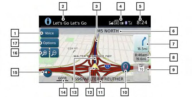
SCREEN INFORMATION
䊐
6 Next maneuver road name:
Indicates the name of the next road in
the route guidance. This is only shown
if route guidance is active.
䊐
7 Direction indicator and distance to
next maneuver on the route:
When route guidance is active but you
have deviated from the route, this area
displays a compass icon with an arrow
indicating the destination direction.
When route guidance is active and you
are on the route, this area indicates
the distance (in miles or kilometers) to
the next point and the turning direc-
tion at that point.
LNV3010
䊐
1 “Voice” key: 䊐
3 Current route: When the “Voice” key is not shown on
Touch to repeat the voice guidance A blue line indicates the path to follow. the screen (such as when an audio
screen is displayed on the screen),
while a route is active. Touch and hold
for two seconds to toggle the voice 䊐
4 Satellite and Bluetooth connection in- touch the direction indicator to repeat
formation: the voice guidance while a route is
guidance on or off (button will be
This area shows satellite and/or active. Touch and hold for two sec-
grayed out when voice guidance is
Bluetooth connections, indicates un- onds to toggle the voice guidance on
turned off). This option is available only
read text messages and illustrates a or off.
when a route is set.
connected cell phone’s battery and
䊐
2 Audio information: signal strength.
Indicates the radio station, CD track
number or other audio information 䊐
5 Clock:
Indicates the current time.
currently playing.
3-2 Map settingsMAP TYPES
䊐
8 Estimated time of arrival and distance 䊐
12 Vehicle icon:
to destination or remaining time of Indicates the current location and di-
travel and distance to destination: rection of the vehicle.
Touch this button to switch the indica-
tor between estimated arrival time
䊐
13 Suggested route:
Appears as a bold blue line during
and remaining travel time. This indica- route guidance.
tor only appears once the destination
is set and the route guidance is 䊐
14 Scale indicator:
initiated. The estimated arrival time Indicates the scale of the map.
may not switch to the estimated ar- 䊐
15 Compass icon:
2D LNV2455
rival time for the destination’s time Indicates the direction of the map.
zone if a time zone line is crossed as Touch this icon to switch the map view 2-DIMENSIONAL (2D) VIEW
part of the route. between the North Up, Heading Up (or
The 2D map is a two-dimensional (flat)
actual direction) and 3D modes.
䊐
9 Posted speed limit: representation of the map data, similar to
When available, the posted speed limit 䊐
16 Zoom in and zoom out keys: a road map, focused on the vehicle’s posi-
for the current road is displayed. Touch to zoom the map perspective in tion (vehicle icon).
or out.
䊐
10 NissanConnectSM Services (if so Touch the compass icon to switch map to
equipped): 䊐
17 “Options” key: another view.
Touch the headset icon to connect to Touch this key to access the map op-
“SCREEN INFORMATION (2D, 2DN
NissanConnectSM Services. tions menu screen.
or 3D)” (page 3-2)
“MAP OPTIONS MENU
“NISSANCONNECT SERVICES” “MAP SETTINGS FOR THE MAP
SCREEN” (page 3-5)
(page 6-4) SCREEN” (page 3-7)
䊐
11 Current road indicator:
This displays the name of the road
upon which the vehicle is currently
traveling.
Map settings 3-3MOVING A MAP
LNV2463
2DN LNV2454 3D LNV2456
To scroll the map in either direction:
2-DIMENSIONAL NORTH UP (2DN) 3-DIMENSIONAL (3D) VIEW
1. Touch and release the screen any-
VIEW The 3D map displays the map from an el- where on the map.
The 2DN map is a two-dimensional (flat) evated perspective, providing a panoramic
view over a long distance. 2. Touch the screen again and move
representation of the map data, similar to
your finger along the screen in the di-
a road map, focused on the vehicle’s posi- The map in 3D view always appears with rection you wish to scroll.
tion (vehicle icon) with the top of the map the current forward direction facing up
aligned North. (heading up). After releasing and touching the map
again, a marker will be displayed at the
Touch the compass icon to switch map to Touch the compass icon to switch map to point touched and, if possible, the position
another view. another view. determined.
3-4 Map settingsMAP OPTIONS MENU SCREEN
The Map Options menu allows you to
NOTE: quickly store the current position, show
When the current location of the vehicle position information or destination
is recognized, the street name will be information, and adjust the map settings.
displayed at the bottom of the screen.
When scrolling a map and an area that is
not a road, city or POI is touched, coordi-
nates corresponding to the marker’s po-
sition are displayed at the bottom of the
screen. LNV2700
RETURNING TO THE CURRENT VE- 1. Touch the “Options” key while the route
HICLE LOCATION guidance map is displayed.
2. The following options are available for
The basic map screen displays the current
selection:
location of the vehicle. The current location
can be displayed again even after the map ∙ Enter Destination
is moved, or after the menu screen is Select to open the navigation screen
displayed. for entering an address.
Press the MAP button or the BACK button ∙ Turn List
and the current location will be displayed Select to display all of the turns and
on the map. waypoints along the route.
∙ Cancel Route
Select to cancel entire route or way-
points along route.
Map settings 3-5CHANGING THE MAP SCALE
∙ POIs Along Route ∙ Routing Options
Select to choose the types of points Select to view options available to
of interest to display along the active customize route. Avoiding specific
route. Available options are gas roads, dynamic guidance, route type
stations, restaurants, ATMs, parking, and minimizing freeways, types of
rest areas, hotels, dealerships and roads and ferries can all be adjusted.
airports.
∙ Show Position Information
NOTE: Select to display the latitude, longi-
tude and altitude for the current po-
Some places of interest on divided high- sition of the vehicle. Location can LNV2462
ways may show the equivalent place of also be stored to the Address Book. When using the “+” or “-” for zooming in or
interest on the opposite side of the road out, the scale on the bottom left side of the
(such as a rest area) as being closer than ∙ Show Waypoints
Select to add or show list of way- screen changes to indicate the new scale
the place in your traveling direction. level.
Confirm location of the place before fol- points along route.
lowing the route. ∙ Guidance & Map Settings
∙ SiriusXM Traffic Select to toggle guidance informa-
Select to display all traffic events on tion and map settings options.
route and options to avoid roads “MAP SETTINGS FOR THE MAP
along route. SCREEN” (page 3-7)
∙ Show Route On Map
Select to display the entire route on
the screen. The view will zoom to the
necessary level in order to show
both the starting point and destina-
tion on the screen.
3-6 Map settingsLOOKING AT INFORMATION ON THE
MAP
MAP SCALE Icons of various categories of locations
can be displayed on the map.
The following scales are available depend-
ing on the map view: MAP SYMBOLS
Per approximately 1/2 inch (1 cm) This navigation system uses symbols to
150 ft (50 m) display various types of facilities. The fol-
lowing icons (if so equipped) may be used
300 ft (100 m)
on the map screen.
600 ft (200 m)
1/4 mile (500 m)
1/2 mile (1 km)
1 mile (2 km)
2.5 mi (5 km)
5 mi (10 km)
10 mi (20 km)
25 mi (50 km)
50 mi (100 km)
100 mi (200 km)
250 mi (500 km)
Map settings 3-7LNV2467 3-8 Map settings
MAP SETTINGS FOR THE MAP
SCREEN

                                        LNV2704                                                 LNV2701
Other settings are available for the map             3. Touch the “Navigation” key.
screen, such as switching the map view or
changing the map direction.                          4. Touch the “Guidance & Map Settings”
                                                        key.
 1. Press the                 button.
                                                         When selected, the system will offer
 2. Touch the “Settings” key.                            the following map setting options:
                 Menu Item                                                                        Options
Voice Guidance                              Select to toggle on or off the voice guidance on map screen.
Volume                                      Select “+” or “-” to increase or decrease voice guidance volume.
Map View                                    Touch the “Map View” key to toggle between 2D and 3D map view.
2D-North/Heading Up                         Touch to toggle display between “Head” and “North” for 2D mode. When “Head” is selected, the screen always
                                            shows the map in the driving direction. When “North” is selected, the top of the map is always orientated north.
                                            This option can only be selected when the “Map View” is set to 2D.
Auto Zoom                                   Touch the “Auto Zoom” key to choose a setting for automatic zooming. Available settings are “Never”, “Always” and
                                            “Only with a route”.
Show Points of Interest On Map              Select to toggle various map icons on and off including gas stations, restaurants, banks and parking.
My Points of Interest Alert                 Select to control alert options. Choose “Off” to disable the alert. Choose “Show Only” to have the alert displayed on
                                            the screen. Choose “Show & Beep” to have an audible beep in addition to the alert displayed on the screen.

                                                                                                                                         Map settings 3-9
Menu Item Options
Show Presets On Map Select to toggle on or off the preset radio station buttons on the map screen.
Split Map for Freeway Exits Select to toggle on or off the split view map when approaching a freeway exit.
Show Lane Information Select to toggle on or off lane information when available.
Show Speed Limit Select to toggle on or off the display of speed limit information when available.
Show Estimated Time Select to control display of estimated time of arrival or trip time remaining.
Customize Travel Speed Select to customize travel speeds on local roads and freeways along route.
Speed Limit Warning Select to control the speed limit alert that activates when the vehicle speed is greater than the speed limit infor-
mation for the current location. Choose “Off” to disable the alert. Choose “Show Only” to have the alert displayed
on the screen. Choose “Show & Beep” to have an audible beep in addition to the alert displayed on the screen.
Speed Limit Sensitivity Select the sensitivity level for the speed limit warning. Choose a value between zero and 30
Speed Warning for Curves Select to control the alert that activates depending on vehicle speed and a curve in the road ahead. Choose “Off”
to disable the alert. Choose “Show Only” to have the alert displayed on the screen. Choose “Show & Beep” to have
an audible beep in addition to the alert displayed on the screen.
Distance Units Select to toggle “US” or “Metric” for the distance units on the map screen.
3-10 Map settingsLANE INFORMATION
Once the vehicle passes through the junc-
tion or interchange, the screen returns to
the previous view.
LNV2464 LNV2465
When the vehicle is approaching a junction
or interchange, the screen switches to a NOTE:
split view. Lane information is graphically Lane information is not available for all
displayed on the left side of the split areas. It will only be displayed in areas
screen and icons showing the proper where the necessary map data is
lanes for upcoming maneuvers are shown available.
in the upper right corner below the clock.
NOTE:
The highlighted lanes are those from
which the next maneuver on the route will The number of lane icons in the upper
be made. Lanes displayed in gray are right corner may change as the junction
those that do not follow the route at the or interchange approaches due to a dif-
ference in the number of available lanes.
upcoming junction or interchange. The
icons in the upper right corner also indi-
cate direction and may change as the
junction or interchange approaches (for
example, straight ahead, to straight and
then right).
Map settings 3-11MAP SD-CARD
will not appear if the SD-card is removed ∙ Handle the SD-card carefully to
while in audio mode. The audio mode is avoid contamination or flaws.
not affected by the SD-card. Otherwise, the data may not be
HOW TO HANDLE THE SD-CARD read properly.
When handling the SD-card, please be ∙ Do not store the SD-card in loca-
careful and adhere to the following in- tions exposed to direct sunlight, or
structions: in high temperatures or humidity.
∙ Always place the SD-card in its
LNV2388 storage case when not in use.
CAUTION
The SD-card slot is located on the front of
the unit. When you purchase this system, ∙ Handle the SD-card with care. SD-CARD REPLACEMENT
an SD-card with map data is provided. Never touch the metal contacts. For additional SD-cards with map data,
∙ Do not use any conventional contact the NISSAN Navigation Helpdesk.
NOTE: cleaner, benzine, thinner, or anti-
∙ Before inserting the map SD-card con- static spray. HOW TO ORDER MAP DATA UP-
firm that there is no SD-card already in DATES
∙ If you need to clean the SD-card use
the slot. a soft cloth. To order updated map data and voice
∙ The SD-card slot can only read the SD- ∙ Never attempt to use an SD-card commands, contact the NISSAN Naviga-
card with map data provided specifically that has been cracked, deformed or tion Helpdesk. See the contact information
for use with the vehicle’s navigation repaired using adhesive. Doing so on the inside front cover of this manual.
system. The system will not read other
may damage the equipment. ABOUT THE MAP DATA
SD-cards.
∙ Do not try to bend the SD-card. Do ∙ Bosch has compiled the digitized map
∙ If an SD-card with something other than
not use any SD-card that is bent or data into a usable format. © 2011 Robert
map data (such as music, pictures or
movies) is inserted into the slot, the Navi-
cracked. Bosch GmbH all rights in compilation
gation System will not function. A mes- ∙ Do not put on any sticker or write software reserved. Due to the production
sage will appear prompting for the map anything on the SD card. timing of the map data, some new roads
SD-card to be reinserted. This message may not be included, or some names
3-12 Map settingsand roads may be different from those in ∙ The advice provided by the naviga- – In order to avoid a traffic
use at the time this map data is used. tion system is to be regarded as a accident, operate the system
∙ Traffic control and regulation data used suggestion only. There may be only when the vehicle is stopped
in this map data may be different from times when the navigation system at a safe place and the parking
those in use at the time this map data is displays the vehicle’s location brake is on.
used. When driving, follow the actual traf- incorrectly, fails to suggest the – In order to avoid a traffic accident
fic control signs and notices on the shortest route, or fails to direct you or traffic offence, remember that
roads. to your desired destination. In such actual road conditions and traffic
instances, rely on your own judge- regulations take precedence over
∙ Reproducing or copying this map soft- ment taking into account the driv-
ware is strictly prohibited by law. the information contained on the
ing conditions at the time. navigation system.
∙ Do not use the navigation system
m WARNING to locate emergency services. The
– The software may contain inac-
curate or incomplete informa-
database does not contain a com- tion due to the passage of time,
∙ This navigation system should not
plete listing of emergency services changing circumstances, and
be used to replace your own
such as police stations, fire the sources of information used.
judgement. No itinerary suggested
stations, hospitals and walk-in Please respect current traffic
by this navigation system should
clinics. Please show discretion and conditions and regulations at all
ever override any freeway
ask for directions in such instances. times while driving.
regulations, your own judgement,
or a knowledge of safe driving ∙ As the driver, you alone are respon- – Where actual road conditions
practices. Do not follow the naviga- sible for your driving safety. and highway regulations differ
tion system’s suggested itinerary if – In order to avoid a traffic from the information contained
it would cause you to perform a accident, do not operate the sys- on the navigation system, abide
dangerous or illegal act, place you tem while driving. by the highway regulations.
in a dangerous situation, or take
you into an area you consider – Keep the amount of time spent
unsafe. viewing the screen while driving
to a strict minimum.
Map settings 3-13The navigation system does not provide, The Data for areas of Canada includes in- ing but not limited to, effectiveness,
nor represent in any way information on: formation taken with permission from Ca- completeness, accuracy or fitness for a
traffic and highway regulations; technical nadian authorities, including: © Her Maj- particular purpose.
aspects of the vehicle including weight, esty the Queen in Right of Canada, ©
The licensors, including Her Majesty,
height, width, load and speed limits; road Queen’s Printer for Ontario, © Canada Post
Canada Post and NRCan, shall not be liable
conditions including grade, percentage of Corporation, GeoBase®, © Department of
in respect of any claim, demand or action,
incline and surface conditions; obstacles Natural Resources Canada.
irrespective of the nature of the cause of
such as the height and width of bridges
NAVTEQ holds a non-exclusive license the claim, demand or action alleging any
and tunnels; and other current driving or
from the United States Postal Service® to loss, injury or damages, direct or indirect,
road conditions. Always rely on your own
publish and sell ZIP+4® information. which may result from the use or posses-
judgement when driving a car, taking into
sion of the data or the Data. The licensors,
account current driving conditions. ©United States Postal Service® 2009.
including Her Majesty, Canada Post and
Prices are not established, controlled or
The company trademarks used in this NRCan, shall not be liable in any way for
approved by the United States Postal
product to identify locations and business loss of revenues or contracts, or any other
Service®. The following trademarks and
offices are the trademarks of their respec- consequential loss of any kind resulting
registrations are owned by the USPS:
tive owners. Their use does not represent from any defect in the data or the Data.
United States Postal Service, USPS, and
sponsorship, approval or recommenda-
ZIP+4. End User shall indemnify and save harm-
tion of this product by these companies.
less the licensors, including Her Majesty,
The Data may include or reflect data of
END-USER TERMS licensors, including Her Majesty the Queen
Canada Post and NRCan, and their officers,
employees and agents from and against
The data (“Data”) is provided for your in the Right of Canada (“Her Majesty”),
any claim, demand or action, irrespective
personal, internal use only and not for Canada Post Corporation (“Canada Post”)
of the nature of the cause of the claim, de-
resale. It is protected by copyright, and is and the Department of Natural Resources
mand or action, alleging loss, costs,
subject to the following terms and condi- Canada (“NRCan”). Such data is licensed on
expenses, damages or injuries (including
tions which are agreed to by you, on the an “as is” basis. The licensors, including Her
injuries resulting in death) arising out of
one hand, and NISSAN and its licensors (in- Majesty, Canada Post and NRCan, make no
the use or possession of the data or the
cluding their licensors and suppliers) on guarantees, representations or warranties
Data.
the other hand. respecting such data, either express or
implied, arising by law or otherwise, includ-
© 2011 NAVTEQ. All rights reserved.
3-14 Map settingsTerms and conditions Restrictions: No Warranty:
Except where you have been specifically li- This Data is provided to you “as is,” and you
Personal Use Only: censed to do so by NISSAN and without agree to use it at your own risk. NISSAN
You agree to use this Data together with limiting the preceding paragraph, you may and its licensors (and their licensors and
NISSAN Automotive Products for the solely not: suppliers) make no guarantees, represen-
personal, non-commercial purposes for tations or warranties of any kind, express
which you were licensed, and not for ser- a. use this Data with any products,
or implied, arising by law or otherwise, in-
vice bureau, timesharing or other similar systems, or applications installed or
cluding but not limited to, content, quality,
purposes. Accordingly, but subject to the otherwise connected to or in commu-
accuracy, completeness, effectiveness,
restrictions set forth in the following nication with vehicles, capable of ve-
reliability, fitness for a particular purpose,
paragraphs, you may copy this Data only hicle navigation positioning, dispatch,
usefulness, use or results to be obtained
as necessary for your personal use to view real time route guidance, fleet manage-
from this Data, or that the Data or server
it, and save it, provided that you do not re- ment or similar applications;
will be uninterrupted or error-free.
move any copyright notices that appear b. use this Data with or in communication
and do not modify the Data in any way. You Disclaimer of Warranty:
with any positioning devices or any mo-
agree not to otherwise reproduce, copy, NISSAN AND ITS LICENSORS (INCLUDING
bile or wireless-connected electronic or
modify, decompile, disassemble or reverse THEIR LICENSORS AND SUPPLIERS) DIS-
computer devices, including without
engineer any portion of this Data, and may CLAIM ANY WARRANTIES, EXPRESS OR
limitation mobile phones, palmtop and
not transfer or distribute it in any form, for IMPLIED, OF QUALITY, PERFORMANCE, MER-
handheld computers, pagers, and per-
any purpose, except to the extent such re- CHANTABILITY FITNESS FOR A PARTICULAR
sonal digital assistants or PDAs.
strictions are expressly prohibited or lim- PURPOSE OR NON-INFRINGEMENT.
ited by applicable law. Warnings:
Some countries, local laws and territories
The Data may contain inaccurate or in-
do not allow certain warranty exclusions,
complete information due to the passage
so to that extent the above exclusion may
of time, changing circumstances, sources
not apply to you.
used and the nature of collecting compre-
hensive geographic data, any of which
may lead to incorrect results.
Map settings 3-15Disclaimer of Liability: Export control: NISSAN AND ITS LICENSORS (INCLUDING You agree not to export from anywhere THEIR LICENSORS AND SUPPLIERS) SHALL any part of the Data provided to you or any NOT BE LIABLE TO YOU: IN RESPECT OF ANY direct product thereof except in compli- CLAIM, DEMAND OR ACTION, IRRESPECTIVE ance with, and with all licenses and ap- OF THE NATURE OF THE CAUSE OF THE provals required under, applicable export CLAIM, DEMAND OR ACTION ALLEGING ANY laws, rules and regulations. LOSS, INJURY OR DAMAGES, DIRECT OR INDIRECT, WHICH MAY RESULT FROM THE Entire Agreement: USE OR POSSESSION OF THE INFORMA- These terms and conditions constitute the TION; OR FOR ANY LOSS OF PROFIT, entire agreement between NISSAN (and its REVENUE, CONTRACTS OR SAVINGS, OR licensors, including their licensors and ANY OTHER DIRECT, INDIRECT, INCIDENTAL, suppliers) and you pertaining to the sub- SPECIAL OR CONSEQUENTIAL DAMAGES ject matter hereof, and supersedes in their ARISING OUT OF YOUR USE OF OR INABIL- entirety any and all written or oral agree- ITY TO USE THIS INFORMATION, ANY DE- ments previously existing between us with FECT IN THE INFORMATION, OR THE respect to such subject matter. BREACH OF THESE TERMS OR CONDITIONS, WHETHER IN AN ACTION IN CONTRACT OR TORT OR BASED ON A WARRANTY, EVEN IF NISSAN OR ITS LICENSORS (OR THEIR LI- CENSORS OR SUPPLIERS) HAVE BEEN AD- VISED OF THE POSSIBILITY OF SUCH DAMAGES. Some countries or local laws do not allow certain liability exclusions or damages limitations, so to that extent the above may not apply to you. 3-16 Map settings
4 Navigation

About route guidance . . . . . . . . . . . . . . . . . . . . . . . . . . . 4-2                   Setting a new entry to the address
   Voice guidance during route guidance. . . . . . . . 4-2                                       book . . . . . . . . . . . . . . . . . . . . . . . . . . . . . . . . . . . . . . . . 4-17
Navigation screen . . . . . . . . . . . . . . . . . . . . . . . . . . . . . . . 4-3              Setting an entry as a destination . . . . . . . . . . . . 4-18
   Basic operation . . . . . . . . . . . . . . . . . . . . . . . . . . . . . . 4-3               Setting a destination from the address
   Available setting items . . . . . . . . . . . . . . . . . . . . . . . 4-3                     book using Voice Recognition
Setting a destination . . . . . . . . . . . . . . . . . . . . . . . . . . . . 4-5                (if so equipped) . . . . . . . . . . . . . . . . . . . . . . . . . . . . . . 4-18
   Available destination setting methods. . . . . . . . 4-5                                   Setting an intersection as a destination . . . . . . . . 4-18
Setting a destination from a street address. . . . . . 4-6                                    Setting a city center as a destination . . . . . . . . . . . 4-19
Setting a destination from points of interest . . . . . 4-9                                   Traffic feature . . . . . . . . . . . . . . . . . . . . . . . . . . . . . . . . . . 4-20
   Searching for nearby restaurants or                                                           Displaying traffic events along route . . . . . . . . . 4-20
   gas stations . . . . . . . . . . . . . . . . . . . . . . . . . . . . . . . . . 4-10           Traffic flow feature. . . . . . . . . . . . . . . . . . . . . . . . . . . 4-21
   Searching for places near current                                                             Traffic settings. . . . . . . . . . . . . . . . . . . . . . . . . . . . . . . 4-21
   location . . . . . . . . . . . . . . . . . . . . . . . . . . . . . . . . . . . . . .4-11
                                                                                              Fuel prices. . . . . . . . . . . . . . . . . . . . . . . . . . . . . . . . . . . . . . 4-22
   Searching for points of interest in
   another city . . . . . . . . . . . . . . . . . . . . . . . . . . . . . . . . . 4-12        Weather . . . . . . . . . . . . . . . . . . . . . . . . . . . . . . . . . . . . . . . . 4-22
   Searching for places using Voice                                                              Displaying weather information on the
   Recognition (if so equipped) . . . . . . . . . . . . . . . . . 4-13                           screen. . . . . . . . . . . . . . . . . . . . . . . . . . . . . . . . . . . . . . . 4-23
   My points of interest/User-defined                                                         Stocks. . . . . . . . . . . . . . . . . . . . . . . . . . . . . . . . . . . . . . . . . . 4-24
   points of interest (POIs) . . . . . . . . . . . . . . . . . . . . . . 4-13                 Sports . . . . . . . . . . . . . . . . . . . . . . . . . . . . . . . . . . . . . . . . . . 4-25
Setting a destination from the address book . . . 4-17                                        Movie Listings . . . . . . . . . . . . . . . . . . . . . . . . . . . . . . . . . . 4-25
ABOUT ROUTE GUIDANCE
After setting the destination, select “Start”
to begin route guidance.
During route guidance, the system navi-
gates you through the guide points using
visual and voice guidance.
CAUTION
∙ The navigation system visual and
voice guidance is for reference pur-
poses only. The contents of the
guidance may be inappropriate de-
pending on the situation.
∙ When driving along the suggested
route, follow all traffic regulations
(for example, one-way traffic). LNV0943
“Route guidance” VOICE GUIDANCE DURING ROUTE Example of voice guidance:
(page 6-3) GUIDANCE 䊐
1 “In about one quarter mile
When approaching a guide point (intersec- (400 meters), right (or left) turn.” “Right
tion or corner), destination, etc., during (or left) turn ahead.”
route guidance, voice guidance an- 䊐
2 “In about one quarter mile (400 meters)
nounces the remaining distance and/or freeway entrance on your right onto
turning direction. (road number and direction).” “Freeway
Touch “Voice” on the upper left of the entrance on your right onto (road
screen to repeat the voice guidance. number and direction).”
4-2 NavigationNAVIGATION SCREEN
䊐
3 “In about one mile (1.6 kilometers), exit
on your right.” “Take the second exit on
your right.”
䊐
4 “You have reached your destination.
Ending route guidance.”
LNV2409 LNV2703
BASIC OPERATION AVAILABLE SETTING ITEMS
1. Press the NAV button.
∙ Street Address:
2. Select the appropriate destination set- Set a destination address.
ting method by touching the screen or
Several methods are available to set
scrolling with the tune-scroll knob.
your destination.
“SETTING A DESTINATION”
(page 4-5)
∙ Points of Interest:
The system features a database of
places such as restaurants, hotels, banks
and more to assist you in navigation.
These points of interest can be set as
destinations and the system can then
calculate a route.
∙ Cancel Route:
Touch “Cancel Route” to cancel the route
guidance.
Navigation 4-33. Say “Previous destinations”. Home can also be set as a destination us-
NOTE: ing the NISSAN Voice Recognition System
4. Speak the number of an entry on the
If route guidance is not active, “Cancel (if so equipped):
displayed list to choose that destina-
Route” cannot be operated. tion or say “Next Page” to view more 1. Press the or button on the
∙ Previous Destinations: entries (if available). steering wheel. The system provides
Searches for a destination from the pre- prompts and waits for voice
If no route is set, route guidance is cal- commands.
vious destinations in the destination culated automatically. If a route is set,
memory. say “Replace Destination” to use the 2. Say “Navigation”.
Up to 50 previous destinations will be chosen previous destination in Step 4 3. Say “Home”.
automatically stored. If the number of as the new destination. Say “Set as
previous destinations exceeds 50, the Waypoint” to add the chosen previous If a home location is set, route guidance to
oldest one will be removed from the destination as a waypoint on the cur- the home location is calculated
list and the newest one will be added. rent route. Say “Show on Map” to show automatically.
the chosen previous destination on For more information about the NISSAN
To manually delete a previous destina- the map.
tion entry, select an entry from the list Voice Recognition System, see the vehicle
and then touch the “Delete” key. For more information about the Owner’s Manual.
NISSAN Voice Recognition System, re- ∙ Address Book:
Touch the “Save” key to add a previous fer to the vehicle Owner’s Manual.
destination to the address book. Touch “Address Book” to access stored
addresses.
Previous destinations can also be se- NOTE:
lected using the NISSAN Voice Recog- ∙ City Center:
It is not possible to retrieve deleted pre- Select “City Center” to designate a city as
nition System (if so equipped): vious destination entries. a destination.
1. Press the or button on the ∙ Home:
steering wheel. The system provides ∙ Connected Search (if so equipped):
Your home address can be entered as a Touch “Connected Search” to use Nissan-
prompts and waits for voice destination.
commands. Connect Services to search for a
destination.
2. Say “Navigation”.
4-4 NavigationSETTING A DESTINATION
∙ Intersection: Press the NAV button. The methods for ∙ Address Book
Select “Intersection” to designate an in- setting a destination are shown.
“SETTING A DESTINATION
tersection of two roads as a destination.
If route guidance is active, you can choose FROM THE ADDRESS BOOK”
∙ My Points of Interest: how to use the new destination. Select (page 4-17)
My Points of Interest are locations en- “Add as Waypoint” to keep the current des-
tered into the system via the vehicle’s tination and to add the current destination ∙ City Center
USB port. as a waypoint along the route. Select “Re- “SETTING A CITY CENTER AS A
“MY POINTS OF place” to cancel the current route and re- DESTINATION” (page 4-19)
INTEREST/USER-DEFINED place the current destination with the new
destination. ∙ Intersection
POINTS OF INTEREST (POIs)”
(page 4-13) “SETTING AN INTERSECTION
AVAILABLE DESTINATION SETTING AS A DESTINATION”
METHODS (page 4-18)
∙ Street Address
“SETTING A DESTINATION
FROM A STREET ADDRESS”
(page 4-6)
∙ Points of Interest
“SETTING A DESTINATION
FROM POINTS OF INTEREST”
(page 4-9)
∙ My Points of Interest
“MY POINTS OF
INTEREST/USER-DEFINED MY
POINTS OF INTEREST”
(page 4-13)
Navigation 4-5SETTING A DESTINATION FROM A
STREET ADDRESS
NOTE:
It is possible to choose “House Number &
Street” at this step if you want to manu-
ally enter the street name. However, the
system can automatically narrow down
the street in most cases when you enter
the city name first. Entering by city can
also be useful if you are unsure of the
LNV2710 LNV2415 street’s correct spelling.
1. Press the NAV button. 4. Enter the name of the state or
province. The display shows the touch
2. Touch “Street Address”.
keyboard.
3. If the state or province shown on the
“HOW TO INPUT CHARAC-
screen is correct, proceed to step 5. If
the state or province shown on the TERS” (page 2-7)
screen is not correct, touch “Change The keyboard has an intelligent spell-
State/Province”. ing setting, so it excludes non-existing
combinations. On the top right of the
screen, the number of matches is
shown. At any time, touch the “List” key
to display a list of possible names
based on the letters currently entered.
When the number of matches is re-
duced to six or less, a list will be shown
automatically.
5. Touch “City”
4-6 NavigationLNV2406 LNV3013 LNV2411
6. The display shows a touch keyboard 7. Touch the city name on the list. 8. The display shows a touch keyboard
to enter the city of the destination. En- to enter the house number of the
ter the name of the city. At any time, destination. If the house number is not
touch the “List” key to display a list of known, touch “Skip” and a default loca-
possible city names based on the let- tion on the street will be used.
ters currently entered. When the num-
ber of matches is reduced to six or NOTE:
less, the city list will be shown
If you choose “Skip”, a default location is
automatically.
chosen by the system and you will have
a chance to change the position once
the map is displayed. See step 12 for
more instructions on changed the de-
fault location.
Navigation 4-7LNV2412 LNV2413 LNV2438
9. The display shows a touch keyboard to 10. Touch the street name on the list. 12. A map of the destination is displayed
enter the street name. Enter the name on the screen. Touch “Start” to calculate
11. If the house number entered in step 8
of the street. At any time, touch the the route.
does not exist on the street in the cho-
“List” key to display a list of possible
sen city, “The house number is not The map of the destination is always dis-
street names based on the letters cur-
available” will be displayed. Select “Show played in 2D North Up. Once the “Start” key
rently entered. When the number of
Map” or “Change Number”. is touched, the system returns to the cur-
matches is reduced to six or less, the
street list will be shown automatically. rent map settings.
NOTE:
You will have a chance to change the po- NOTE:
sition from the default location once the If you did not enter an exact street ad-
map is displayed. See step 12 for more dress earlier in the process, the system
instructions on changing the default will have chosen a default location, ei-
location. ther along the street or within a range of
addresses on that street. To move the
map from that default position, touch
the “Move” key. Use the touch screen to
move the map and mark a new location.
Touch “OK” when complete.
“MOVING A MAP” (page 3-4)
4-8 NavigationSETTING A DESTINATION FROM
POINTS OF INTEREST
Touch “Store” to store the location in the 6. When prompted, say the name of the The system features a database of points
address book. street. If the system cannot clearly in- of interest such as restaurants, hotels,
terpret the name of the street, a list is banks and more to assist you in
“SETTING A NEW ENTRY TO THE provided with possible matches. navigation. These points of interest can be
ADDRESS BOOK” (page 4-17) Speak the number of the street dis- set as destinations and the system can
played on the screen. then calculate a route.
A destination can also be set from a street
address using the NISSAN Voice Recogni- 7. When prompted, say the house num- “MY POINTS OF
tion System (if so equipped): ber or say “No House Number” to dis- INTEREST/USER-DEFINED POINTS
1. Press the or button on the play a default location on the chosen OF INTEREST (POIs)” (page 4-13)
street within the chosen city. If the
steering wheel. The system provides
house number spoken is not on the
prompts and waits for voice
chosen street, the system will notify
commands. you that the number is out of range
2. Say “Navigation”. and to restate the number or say “No
House Number”.
3. Say “Enter address in steps”.
If a route is active, say “Replace Destina-
4. When prompted, say the name of the tion” to replace the current destination
state or province. If the system cannot with the new street address or say “Set as
clearly interpret the name of the state Waypoint” to set the new street address as
or province, a list is provided with pos- a waypoint on the current route.
sible matches. Speak the number of
If a route is not set, say “Set as Destination”
the state or province displayed on the
to set the new street address as the desti-
screen. nation and begin route guidance.
5. When prompted, say the name of the Say “Show on Map” to display the new
city. If the system cannot clearly inter- street address on the map.
pret the name of the city, a list is pro-
vided with possible matches. Speak For more information about the NISSAN
the number of the city displayed on Voice Recognition System, see the vehicle
the screen. Owner’s Manual.
Navigation 4-9LNV2409 LNV2711 LNV2407
SEARCHING FOR NEARBY RESTAU- 3. Touch “Nearby Restaurants”, “Nearby 5. Places are shown based on the
RANTS OR GAS STATIONS Gas Stations”, “Nearby Parking” or straight line distance to the current
“Nearby ATMs”. position. The arrow on the right shows
While a wide variety of places can be the direction of the destination. Touch
searched in the system, shortcut buttons 4. The system searches for destinations
the desired destination on the list.
are available for restaurants and gas within 50 miles (80 km) of the current
stations. position. NOTE:
1. Press the NAV button. A maximum of 200 destinations will be
listed when searching with this method.
2. Touch “Points of Interest”.
4-10 NavigationLNV2408 LNV2409 LNV2711
6. A detailed description of the destina- SEARCHING FOR PLACES NEAR 3. Touch “Search by Category”.
tion is provided. CURRENT LOCATION 4. Touch “Near Current Location”.
∙ Press the BACK button to go back 1. Press the NAV button.
and pick another destination. When searching by category, you can
2. Touch “Points of Interest”. browse destinations from a variety of cat-
∙ Touch “Call” to call the destination (if egories and subcategories, including:
a phone number is available) using
the Bluetooth® Hands-Free Phone ∙ All POIs
System. See the vehicle Owner’s ∙ Automotive
Manual for more information about
the Bluetooth® Hands-Free Phone ∙ Banking & Business
System.
∙ Emergency
∙ Touch “Map” to show a map of the
destination. ∙ Hotel/Motel
∙ Touch “Start” to calculate the route to ∙ Leisure
the destination. ∙ Public Places
∙ Restaurant
∙ Shopping
Navigation 4-11∙ City Center 5. Destinations are shown based on the “HOW TO INPUT CHARAC-
distance to the selected position. The TERS” (page 2-7)
∙ Travel
arrow on the right shows the direction
If you choose “By Name”, you can search of the destination. The distance shown The keyboard has an intelligent spell-
for places using a specific name. The is a straight line distance. ing setting, so it excludes non-existing
touch keyboard is shown. combinations. On the top right of the
Touch the desired destination from the list. screen, the number of matches is
“HOW TO INPUT CHARACTERS” shown.
6. A detailed description of the destina-
(page 2-7) tion is provided. 7. Touch “City”.
NOTE: Press the BACK button to go back and 8. A touch keyboard is displayed. Enter
pick another destination or touch the name of the desired city.
∙ When using “Search By Category”, the “Start” to have the system calculate
system will search for up to 200 matches the route to the destination. Press “List” at any time to display a list of
within 50 miles (80 km) of the current remaining cities. Touch the desired city.
position. SEARCHING FOR POINTS OF IN- 9. If you chose “Search By Category” in
TEREST IN ANOTHER CITY Step 4, you can browse destinations
∙ When using “Search By Name”, the sys-
1. Press the NAV button. from a list of categories and
tem will search for up to 30 matches
subcategories.
within 50 miles (80 km) of the current 2. Touch “Points of Interest”.
position. If you choose “Search By Name” in Step 4,
3. Touch “Search By Category” or “Search you can search for places using a specific
∙ If the destination is not found within the By Name”. name. The touch keyboard is shown.
50 mile (80 km) search radius, you can
search for places around a specific city 4. Touch “In Another City”.
NOTE:
name. 5. Touch “Change State/Province” if the
∙ When using “Search By Category”, the
state or province shown is not correct.
“SEARCHING FOR POINTS OF IN- system will search for up to 200 matches
TEREST IN ANOTHER CITY” 6. If necessary, enter the name of the within 50 miles (80 km) of the chosen city.
(page 4-12) state or province.
∙ When using “Search By Name”, the sys-
The display shows the touch tem will search for up to 30 matches
keyboard. within 50 miles (80 km) of the chosen city.
4-12 NavigationYou can also read


