TACOMA HARBOR, WA FEASIBILITY STUDY PIERCE COUNTY, WASHINGTON - APPENDIX H - PHASE 1 ENVIRONMENTAL SITE ASSESSMENT - July 2021
←
→
Page content transcription
If your browser does not render page correctly, please read the page content below
TACOMA HARBOR, WA
           FEASIBILITY STUDY
     PIERCE COUNTY, WASHINGTON
APPENDIX H – PHASE 1 ENVIRONMENTAL SITE ASSESSMENT

                                  AL
                                 N
                          FI
                    F
               O
          T
 AF
R

                     July 2021
D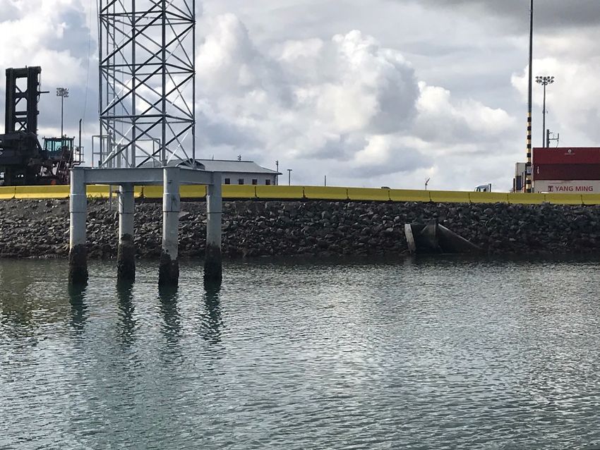
AL
                                  N
                        FI
               F
    Blank page to facilitate duplex printing
      O
    T
 AF
R
D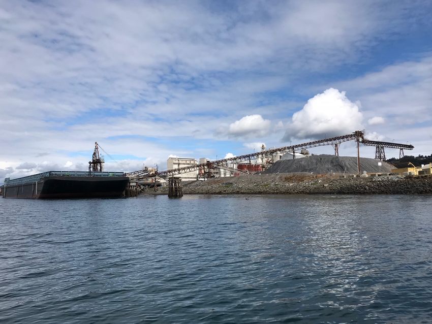
Tacoma Harbor Deep Draft Navigational General Investigation
                      Blair Waterway
                                                              Tacoma, Washington

                                               PHASE I

                                                                                                                       AL
                                     ENVIRONMENTAL SITE ASSESSMENT

                                                                                                         N
                                                                                        FI
                                                                       F
                                                         O

--------------------------------------------------------------------------------------------------------------------------------------------------           -------------
                                        T
   AF

December 2019
  R
D

Prepared By
 U.S. Army Corps of Engineers
 Seattle District
 Environmental Engineering & Technology Section

---------------------------------------------------------------------------- -----------------------------------------------------------------------------          ------
This page intentionally left blank

                                         AL
                                N
                      FI
           F
    O
    T
 AF
R
D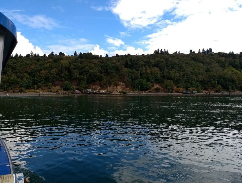
Tacoma Harbor Deep Draft Navigation General Investigation
                                                Phase I ESA

TABLE OF CONTENTS

ACRONYMS & ABBREVIATIONS ........................................................................................................................................ ii
1.0 INTRODUCTION ............................................................................................................................................................. 3
   1.1 Purpose..................................................................................................................................................................... 3
   1.2 Description of the Project Area and Proposal for Federal Action .................................................... 3
   1.3 Scope of Work ........................................................................................................................................................ 3
2.0 SITE DESCRIPTION & PHYSICAL SETTING ........................................................................................................ 5

                                                                                                                                AL
   2.1  General Location ................................................................................................................................................... 5
   2.2  Site Description ..................................................................................................................................................... 5
   2.3  Hydraulics and Geomorphology .................................................................................................................... 6
   2.5  Water Quality and Salinity................................................................................................................................ 6
3.0 ENVIRONMENTAL DATA BASE REVIEW ............................................................................................................ 7

                                                                                                                  N
   3.1 Regulatory Agency Databases Records Search ........................................................................................ 7
   3.2 Known Environmental Conditions ................................................................................................................ 9

                                                                                               FI
4.0 PROPERTY HISTORY .................................................................................................................................................15
   4.1 Property History .................................................................................................................................................15
   4.2 Aerial Photographs and Maps .......................................................................................................................17
   4.3 Records Review...................................................................................................................................................24
                                                                             F
5.0 ADJOINING PROPERTY .............................................................................................................................................24
6.0 RESULTS OF VISUAL RECONNAISSANCE .........................................................................................................24
                                                             O
7.0 SUMMARY OF FINDINGS AND CONCLUSIONS................................................................................................27
Appendix A ...............................................................................................................................................................................28
REFERENCES ..........................................................................................................................................................................30
                                           T

SIGNATURE & QUALIFICATION PAGE ..........................................................................................................................31
ASSESSORS PROFESSIONAL EXPERIENCE .................................................................................................................32
   AF
  R
D

December 2019                                                                                                                                                                     Page i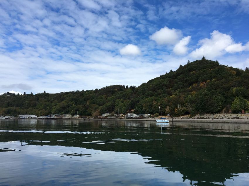
Tacoma Harbor Deep Draft Navigation General Investigation
                                                Phase I ESA

ACRONYMS & ABBREVIATIONS

ASTM                    American Society for Testing and Materials
BT                      Bioaccumulation Trigger
CERCLA                  Comprehensive Environmental Response, Compensation, and Liability Act
CERFA                   Community Environmental Response Facilitation Act
Corps                   U.S Army Corps of Engineers, Seattle District
cPAHs                   Carcinogenic Polycyclic Aromatic Hydrocarbons
CSL                     Cleanup Screening Level

                                                                  AL
CY                      Cubic Yards
DDT                     Dichlorodiphenyltrichloroethane
DMMP                    Dredged Material Management Program
DO                      Dissolved Oxygen
Ecology                 Washington Department of Ecology

                                                              N
EPA                     Environmental Protection Agency
ESA                     Environmental Site Assessment
GI                      General Investigation

                                                      FI
HPHA                    High molecular weight polycyclic aromatic hydrocarbons
HTRW                    Hazardous, Toxic, or Radioactive Waste
MLLW                    Mean Lower Low Water
MTCA                    Model Toxics Control Act
NPL                     National Priorities List
                                            F
OU                      Operable Unit
PCBs                    Polychlorinated Biphenyls
                                   O
RCRA                    Resource Conservation and Recovery Act
REC                     Recognized Environmental Conditions
RI                      Remedial Investigation
ROD                     Record of Decision
                        T

SL                      Screening Level
SVOC                    Semi-volatile organic compound
TBT                     Tributyltin
  AF

TEQ                     Toxic Equivalency
TSS                     Total Suspended Solids
VOC                     Volatile organic compound
 R
D

December 2019                                                                             Page ii
Tacoma Harbor Deep Draft Navigation General Investigation
                                                Phase I ESA

1.0      INTRODUCTION
This Phase I Environmental Site Assessment (Phase 1 ESA) is part of the Tacoma Harbor Deep Draft
Navigation General Investigation (GI). The U.S. Army Corps of Engineers, Seattle District (Corps)
has prepared a final Integrated Feasibility Report and Environmental Assessment, which
documents the process of developing potential solutions to evaluate the environmental impact of
deepening the Blair Waterway. A critical part of the feasibility analysis is the evaluation of known
and suspected hazardous, toxic, or radioactive waste (HTRW) conditions with potential to impact
project planning, design, and implementation. This Phase 1 ESA identifies all known and suspected
HTRW releases, and focuses only on Blair Waterway. A separate Phase I Site Assessment for the

                                                                         AL
Saltchuk beneficial use site is complete.

1.1      Purpose
The purpose of conducting this Phase 1 ESA is to determine the environmental condition of the

                                                                N
proposed project area. This ESA fulfils the requirements of the Comprehensive Environmental
Response, Compensation, and Liability Act (CERCLA) as amended by the Community Environmental
Response Facilitation Act (CERFA). This report identifies known and potential sources of

                                                      FI
environmental risk or liability on the proposed project site, and in the surrounding areas. This
information will assist the Corps’ design team to manage and avoid HTRW hazards at the project site.

1.2      Description of the Project Area and Proposal for Federal Action
                                            F
Blair Waterway is approximately 2.75 miles long, including the turning basin. The waterway is
located in Tacoma, Washington. The authorized dimensions are 520 feet wide from the mouth to
                                    O
11th Street, 345 feet wide through the 11th Street reach, 520 feet from 11th Street to Lincoln
Avenue, 330 feet from Lincoln Avenue to the turning basin, and a 1300 feet turning basin, all to a
depth of -51 feet MLLW (Mean Lower Low Water).

The proposed deepening is considering the costs and impacts of alternatives ranging in depths from
                          T

-51 feet MLLW to -58 feet MLLW.
1.3      Scope of Work
     AF

The scope of work for this assessment was in general accordance with the ASTM International
(ASTM) Standard Practices for Environmental Site Assessments: Phase I Environmental Site
Assessment Process (ASTM E1527 - 13). These methodologies are described as representing good
commercial and customary practice for conducting a Phase I ESA of a property to identify
    R

recognized environmental conditions (RECs). The project effort includes the following tasks:
•     Conduct a record search and review all reasonably attainable federal, state, and local
      government information and records to determine possible onsite sources of hazardous
D

      substances and environmental condition of the project area.
•     Review of all reasonably attainable federal, state, and local government records of adjacent
      facilities with the potential to release contamination to determine possible offsite sources of
      hazardous substances.
•     Analysis of historical data on prior uses of the project site(s) and the surrounding area.
•     Interviews with adjacent property owners and/or tenants or other knowledgeable sources.
•     Visual site inspection of the project area to identify possible hazardous substance sources.

December 2019                                                                                           3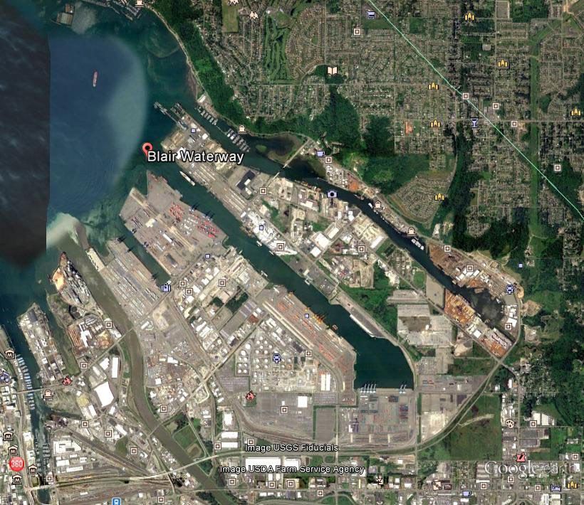
Tacoma Harbor Deep Draft Navigation General Investigation
                                                Phase I ESA

•   Identify contamination sources using data gathered and evaluate what risk they pose and the
    effect to the categorization of the environmental condition of the project area.
•   Identify all ongoing actions that may affect the environmental conditions of the project area.
•   Determine the environmental condition of the project area.
•   Determine the extent to which recognized environmental conditions may impact, or pose a risk
    to, the proposed project

The scope of this report did not include an audit of environmental regulatory compliance issues or
permits, wetland delineation, or collection and testing of environmental samples, including those
for radon gas, lead-based paint, polychlorinated biphenyls (PCBs), asbestos, soil, and/or

                                                                      AL
groundwater condition.

                                                              N
                                                      FI
                                            F
                                   O
                        T
     AF
    R
D

December 2019                                                                                        4
Tacoma Harbor Deep Draft Navigation General Investigation
                                                Phase I ESA

2.0     SITE DESCRIPTION & PHYSICAL SETTING
2.1     General Location
The federally authorized Tacoma Harbor navigation project is located at the mouth of the Puyallup
River in Puget Sound’s Commencement Bay, at Tacoma, Washington. The Tacoma Harbor federal
navigation project consists of Hylebos waterway, Blair Waterway, two training walls at the mouth
of the Puyallup River, and the City Waterway (now called Thea Foss Waterway) (Figure 1). Action
associated with the Tacoma Harbor Deep Draft Navigation GI is limited to the boundaries of Blair
Waterway, thus the focus of this Phase I Environmental Site Assessment is limited to Blair
Waterway and the associated turning basin.

                                                                   AL
                                                              N
                                                      FI
                                            F
                                   O
                        T
  AF

Figure 1: Project Location
 R

2.2     Site Description
Blair Waterway is approximately 2.75 miles long, including the turning basin. The authorized
D

dimensions are 520 feet wide from the mouth to 11th Street, 345 feet wide through the 11th Street
reach, 520 feet from 11th Street to Lincoln Avenue, 330 feet from Lincoln Avenue to the turning
basin, and a 1300 feet turning basin, all to a depth of -51 feet MLLW (Mean Lower Low Water).

The proposed deepening is considering the costs and impacts of alternatives ranging in depths from
-51 feet MLLW to -58 feet MLLW.

December 2019                                                                                       5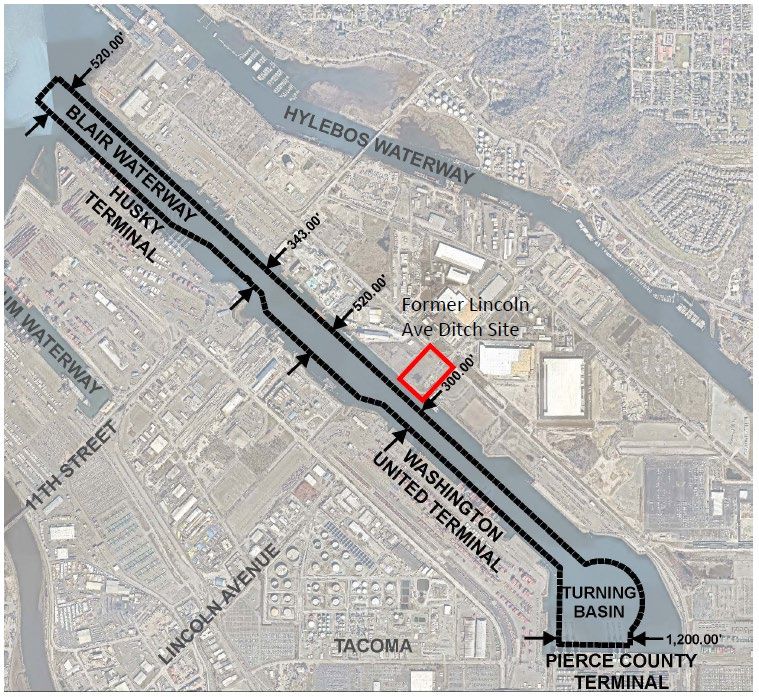
Tacoma Harbor Deep Draft Navigation General Investigation
                                                Phase I ESA

2.3     Hydraulics and Geomorphology
The Puyallup discharges sediment into Commencement Bay at an estimated rate of 1,000,000 tons
per year (Czuba and others, 2010). Depths in Commencement Bay can reach over 600 feet.

Tides in Commencement Bay are the mixed semidiurnal type. The mean diurnal tidal range for
Tacoma published by the National Ocean Survey is 8.06 feet. The great diurnal tidal range for
Tacoma is 11.77 feet.

Blair Waterway has no water inflow/outflow other than tidal influence. As such, currents in the

                                                                       AL
area are generally less than 0.5 knots (0.82 feet per second) during all tidal phases. The stronger
currents are occur at the mouth of the Puyallup River and Hylebos Waterway. At the Blair
Waterway, the currents move parallel to the waterway with the stronger currents being around 0.1
knots (0.16 feet per second) at the mouth of the channel and around 0 knots (0.32 feet per second)
at the head near Pierce County Terminals.

                                                               N
Saltchuk lies within the northwest quadrant of Commencement Bay. Currents move along this
shoreline at the lower speeds of the 0 to .5 knots range. Sediment migration will depend on several

                                                      FI
factors including sediment particle size, current speed, and site configuration. For example, island
creation may decrease already low current speeds further. If any sediment migration occurs, it can
be expected to occur alongshore towards the existing marina or towards the mouth of the Hylebos.
                                            F
2.4     Regional Climate

The central Puget Sound area has a temperate climate. The average annual precipitation for the
                                   O
region is 39.25 inches of rainfall. The majority of this rainfall occurs from October through May.
Average winter temperatures for the area range from 36.5 degrees to 48.5 degrees Fahrenheit, and
average summer temperatures range from 55 degrees to 75 degrees Fahrenheit. (US Climate Data.
2019)
                        T

2.5     Water Quality and Salinity
  AF

Under the Clean Water Act, Washington Department of Ecology (Ecology) establishes standards for
physical parameters of water such as temperature, pH level, dissolved oxygen (DO), and chemical
concentrations. Waters that do not meet standards are considered “polluted waters” and placed on
a 303(d) list that Ecology publishes regularly (in reference to Section 303(d) of the Clean Water
Act). Waters with signs of diminished health but still meet standards are “waters of concern” on the
 R

303(d) list.

Portions of Commencement Bay are on Ecology’s 303(d) list of threatened and impaired waters,
D

listed as “polluted” for specific parameters, although the trend for water quality in the action area is
one of overall improvement (Ecology 2012). Inner Commencement Bay is listed for Bis(2-
Ethylhexyl)phthalate, polychlorinated biphenyls (PCBs). Within the inner bay, Thea Foss Waterway
is listed for PCBs and Hylebos Waterway is listed for dieldrin, PCBs, chlorinated pesticides,
dichlorodiphenyltrichloroethane (DDT), and high molecular weight polycyclic aromatic
hydrocarbons (HPAH). The Blair Waterway is not on the 303(d) list, but benzene,
tetrachloroethylene, and trichloroethylene levels list it under “waters of concern”. Outer
Commencement Bay is listed for bacteria, DO, PCBs, and Bis(2-Ethylhexyl)phthalate.

December 2019                                                                                          6
Tacoma Harbor Deep Draft Navigation General Investigation
Phase I ESA
Turbidity refers to the clarity or clearness of the water. The greater the amount of total suspended
solids in the water, the murkier it appears and the higher the measured turbidity. In general, long-
term increases in turbidity can result in the decreased health in fish, invertebrates, and aquatic
plants. Multiple dredge seasons can increase tissue concentrations or decrease fish health with
repeatable turbidity cycles. Sometimes, large ships entering the Blair Waterway create turbidity
due to the proximity of the propellers to the bottom of the waterway. Sediment can be disturbed
and suspended, temporarily creating a plume of turbidity. The White River, a tributary, glacially
feeds the Puyallup River. High amounts of glacial flour from the White River in the summer can
generate turbidity in the Puyallup River and into Commencement Bay (Puyallup River Watershed
Council 2014).
AL
DO in marine waters is essential for aquatic life. If levels are too low, it can be a sign of human-
induced impacts such as excessive runoff or nutrients, or of natural causes such as seasonal
variations. Conditions for aquatic life are healthy when DO is above 5.0 milligrams per liter (mg/L).
Concentrations between 5.0 mg/L and 3.5 mg/L are acceptable, except for the most sensitive
species. When concentrations fall below 3.5 mg/L, conditions become unhealthy. DO in December
N
1980 were about 6.4 to 7.7 mg/L in the Blair Waterway (Dames and Moore 1981). Outer
Commencement Bay is recognized as impaired for DO because samples taken from 1993-2008 were
below 6 mg/L (Ecology 2018). Commencement Bay is part of the Puget Sound Nutrient Source
FI
Reduction Project to address human sources of nutrients that may lower DO (Ecology 2019).
Temperature has a strong influence on the aquatic organisms that can survive and thrive in any
particular habitat and can affect numbers, sizes, and distributions of biota. Temperatures in
F
October 1980 in the Blair Waterway were about 15 °C at the surface to 12 °C at the bottom, while
temperatures in December were about 10 °C throughout the water column (Dames and Moore
1981). Long-term temperature data are not available for Puget Sound specifically; however, other
O
Pacific Northwest locations indicate a long-term warming trend with an increase of 1°C from 1950
to 2005 (Snover et al. 2005).
3.0 ENVIRONMENTAL DATA BASE REVIEW
T
3.1 Regulatory Agency Databases Records Search
AF
A search of Standard Environmental Records Sources as defined in ASTM E-1527 - 13 was performed
to identify recognized environmental conditions. Reviews of records related to the Property and
nearby properties kept by both Federal and State regulatory agencies were conducted. This review
was used to help identify known or potential sources of contamination that could adversely affect
the Property. Table 1 provides a summary of the ASTM standard environmental records sources
R
databases searched and corresponding radii and quantitative results of the record search
corresponding to databases. More than one database may list findings.
D
Given the highly industrialized nature of the study area, and the bounded nature of the potential
navigation deepening in Blair Waterway, the reduced search radius expanded beyond what
suggested measurements are in the ASTM standard. Table 1specifies the modified search radii.
December 2019 7Tacoma Harbor Deep Draft Navigation General Investigation
Phase I ESA
Table 1. Source Lists and Associated Number of Sites for Blair Waterway
Agency Description Search Radius (miles) Results
US EPA National Priorities 0.5 43
List (NPL)
US EPA Delisted NPL Sites 0.5 04
US EPA CERCLA 0.5 4
US EPA RCRA Generators Property and adjoining 0
properties only
US EPA RCRA Treatment, 0.25 0
AL
Storage, or Disposal
Facilities
US EPA RCRA Corrective 0.5 6
Action Sites
US EPA Institutional Controls Property only 0
N
Registry
US EPA Toxic Release Pierce County, WA 36
Inventory
FI
USCG Emergency Response Property only 1
Notification System
WA Ecology State and Tribal .5 43
Cleanup Sites1
F
WA Ecology State Landfills and 0.25 0
Waste
O
Treatment/Disposal
Plants
WA Ecology State and Tribal 0.25 0
Brownfield’s
T
WA Ecology State and Tribal 0.25 05
Leaking Underground
Storage Tanks
AF
WA Ecology State and Tribal Property and adjoining 71
Registered or properties only
Suspected
Underground Storage
Tanks2
R
WA Ecology State and Tribal Commencement Bay, 22
Environmental Tacoma, WA
Covenants Registry
D
WA Ecology Emergency Spill 0.25 1
Response
1 Includes active cleanups, either started or awaiting cleanup. Does not include No Further Action (NFA) sites.
2 Includes USTs classified as operational, closed in place, or temporarily closed.
3 Includes the Blair Waterway TCRA for TBT contaminated sediments
4 The boundaries of one of the Operable Units (OUs) of Commencement Bay Nearshore Tideflats have been changed to reflect partial
delistings, but the OU itself has not been delisted.
5State and Tribal Leaking Underground Storage Tanks are incorporated into results for State and Tribal Cleanup Sites
December 2019 8Tacoma Harbor Deep Draft Navigation General Investigation
Phase I ESA
3.2 Known Environmental Conditions
There are 43 MTCA sites surrounding Blair Waterway, along with 6 RCRA sites, 4 CERCLA sites, and
4 NPL sites (Table 1). Fifteen of these sites have known contaminated groundwater and are
located immediately next to Blair Waterway. As design progresses for the deepening project,
potential side slope impacts should be evaluated relative to groundwater. The depth and flow
regime of any adjacent groundwater plumes should be evaluated to determine if adverse impacts,
specifically redirecting contaminated groundwater flow towards the channel, result from actions in
the waterway. An additional 5 sites are located one block further away from Blair. Two of the NPL
sites listed, Commencement Bay Nearshore Tideflats and Glenn Springs Holdings, are among the
contaminated groundwater sites immediately next to, but not overlapping, Blair Waterway.
AL
Commencement Bay was placed on the National Priorities List in 1981. The Record of Decision was
issued in September 1989. Blair Waterway was originally included as a component of the
Commencement Bay/Nearshore Tideflats Superfund Site. The Operable Units (OUs) associated with
Blair Waterway include the Commencement Bay/Nearshore Tideflats Sediments OU (OU1) and the
N
Commencement Bay/Nearshore Tideflats Source OU (OU5). The U.S. EPA issued a partial deletion in
1996 pertaining to the portions of the two separate OUs addressing sediments contained in and
properties draining to the Blair Waterway (EPA, 2014).
FI
Separate from the Superfund action, a Time Critical Removal Action at Pier4 (aka Husky Terminal)
occurred in 2015 to remove tributyl tin contaminated sediments. The Port of Tacoma dredged
approximately 71,000 cubic yards of TBT contaminated sediment from the site under the direction
of the US EPA. Construction was completed in 2016. The site was dredged to clean and no
F
additional action was required (Floyd Snider, 2016).
Other State cleanup actions in the uplands have occurred adjacent to the waterway, including
O
Occidental Chemical Corporation (Glenn Spring Holdings), a historic chemical manufacturing
facility. Chlorinated volatile organic compounds, hexachlorobenzene, PCBs, and metals in both soil
and groundwater contaminate the site. The Washington State Department of Ecology manages the
site and in October 2018 finalized a Feasibility Study. While impacted soils, sediment, and
T
groundwater do not directly overlap with the Blair Waterway project footprint, it is notable given
its size and the degree of contamination (Ecology, 2019c). Borehole data indicates geologic material
consists of dense sand and silty sand with layers of clay (Washington Geological Information Portal,
AF
2019). The material at -51 to -57 feet consists predominately of dense sand and has the potential to
transmit contaminated groundwater. While the presence of the groundwater plume is more
concentrated north of the Blair Waterway, confirmation should be performed as design of the
deepening progresses to ensure no impacts to the plume result from construction.
R
TruGrit Abrasives Incorporated is another site managed by the Washington State Department of
Ecology under the MTCA program for upland soils and sediment contaminated with metals. The
study is currently in the feasibility phase. The shoreline bounds the metal contamination in the
D
sediment and does not overlap with the proposed navigation channel. The deepening study design
needs confirmation to ensure side slopes do not intersect with the site (Ecology, 2019c).
Remediation at the Former Lincoln Avenue Ditch site occurred under the U.S. EPA’s Puyallup Land
Transfer Consent Decree. As part of that remediation, institutional controls are in place due to
contamination remaining in place along the shoreline below elevation 12 ft MLLW and extending
approximately 30ft water-ward from top of bank. These institutional controls set limitations on any
future construction and uncontrolled release of contaminated materials resulting from the
construction. Soil and sediments contaminated with arsenic, dioxin, and PCBs above relevant MTCA
thresholds are present. Contaminated groundwater is also present. Borehole data taken south of
December 2019 9Tacoma Harbor Deep Draft Navigation General Investigation
Phase I ESA
the Lincoln Avenue ditch indicate substrate material consists of silty sand and clay layers
(Washington Geological Information Portal, 2019). Higher permeable materials such as sands can
transmit groundwater more readily than lower permeable clay material. Borehole data indicates
materials -51 to -57 feet primarily consists of dense sand and has the potential to transmit
contaminated groundwater. This location overlaps with side slopes associated with the proposed
navigation channel. Given this overlap and presence of institutional controls, coordination with the
U.S. EPA will be required (Ecology, 2019c).
AL
N
FI
F
O
T
AF
Figure 2. Map of the Commencement Bay Nearshore/Tideflats Superfund Site from the 1989 ROD.
Problem Areas are where remedial action was required to address the presence of contamination.
R
D
December 2019 10Tacoma Harbor Deep Draft Navigation General Investigation
Phase I ESA
AL
N
FI
F
O
Figure 3. Boundaries of partial delisting for Blair Waterway sediments and sources, as presented in
T
the 1996 Federal Register.
AF
R
D
December 2019 11Tacoma Harbor Deep Draft Navigation General Investigation
Phase I ESA
AL
N
FI
F
O
T
AF
Figure 4a. Location of the Former Lincoln Ave Ditch Site along Blair Waterway.
R
D
December 2019 12Tacoma Harbor Deep Draft Navigation General Investigation
Phase I ESA
AL
N
FI
F
Figure 4b. Map of institutional controls locations at the Former Lincoln Avenue Ditch site.
O
T
AF
R
D
December 2019 13Tacoma Harbor Deep Draft Navigation General Investigation Phase I ESA
AL
N
FI
F
O
T
AF
R
D
Figure 5. Port of Tacoma 2014 Environmental Remediation Sites
December 2019 14Tacoma Harbor Deep Draft Navigation General Investigation
Phase I ESA
In order to provide conceptual level cost estimates for dredged material disposal during the
feasibility phase, USACE conducted a preliminary suitability determination to provide information
on sediment characterization and inform disposal options. This preliminary suitability
determination only performed a subset of the number of samples that would be required under a
full suitability determination (to be conducted during the pre-construction, engineering, and design
phase). Twenty-five sediment cores were collected throughout the waterway in February 2019.
Analyzed sediment cores occurred in a series of two-foot depth intervals for the standard Dredge
Material Management Program (DMMP) conventional constituents, grain size, metals, volatile
organic compounds (VOCs), semi-volatile organic compounds (SVOCs), polycyclic aromatic
hydrocarbons (PAHs), pesticides, dioxin/furans, and polychlorinated biphenyls (PCBs). Results of
the analyses concluded that the majority of samples were all below Screening Levels (SLs), with
AL
limited SL exceedances in seven cores, mostly concentrated in the middle section of the waterway.
PCBs only exceeded the SL in one surface sample. Dioxins exceedances were more notable, but
even so, only three cores exceeded the Bioaccumulation Trigger of 10 ng/kg TEQ. PAHs were all
less than DMMP SLs.
N
Historic operation of the Asarco Company copper smelter resulted in widespread contamination
across the Puget Sound region. The smelter was in operation for nearly 100 years, resulting in air
pollution that deposited arsenic, lead, and other metals in surface sediment and soils over an area
FI
greater than 1,000 square miles. The impact of the Asarco smelter plume has led to elevated
concentrations of metals, particularly arsenic, on a regional basis (Ecology, 2019b). These historic
operations and resulting contamination provide context for ubiquitous arsenic contamination
throughout the Puget Sound region, including Blair Waterway.
F
4.0 PROPERTY HISTORY
O
4.1 Property History
Information on the historic conditions and development of Commencement Bay is largely
summarized from the Commencement Bay Cumulative Impact Study (Corps 1993) and is
T
incorporated herein by reference.
AF
The earliest photos and maps indicate that prior to 1877, the main habitat types of Commencement
Bay were 2,085 acres of intertidal mudflats and about 3,894 acres of salt/brackish marsh. There
was limited development before 1877 and likely began with the Northern Pacific Railroad that
crossed salt marsh from the City of Puyallup to Tacoma at Foss Waterway in 1874.
R
Development began to increase mostly on the west side of Commencement Bay over the next 20
years by building wharves, piers, and warehouses to store and transfer cargo to or from ships and
the growing railroad system. Excavated mudflats created log storage ponds and associated wharfs
D
for the growing lumber industry. Dredged material included millions of cubic yards from 1894 to
1907 for further development and the creation of Foss Waterway and Middle Waterway. Flooding
and heavy sedimentation from the Puyallup River lead to dredging in the river and relocation
attempts that altered the river delta and modified the intertidal areas by obstructing the outflow
and increasing deposition. By 1907, there were 1,469 acres of mudflat and 3,495 acres of
salt/brackish marsh.
Shoreline development on the east side of Commencement Bay began to increase around 1907. To
expand the Port of Tacoma, dredging occurred on the Milwaukee Slip, Middle Waterway, and
Hylebos Waterway. Mostly lumber trade vessels called at Hylebos Waterway. The North Pacific
December 2019 15Tacoma Harbor Deep Draft Navigation General Investigation
Phase I ESA
Railroad owned and serviced the grain and freight warehouses, ocean freight, coalbunkers, and the
Oriental Dock along the waterfront. Flourmills and lumber mills expanded to the north with grain
elevators, conveyors, and log storage ponds while the Tacoma Smelting Company used slag to fill in
Commencement Bay. Around this time, dikes, ditches, and tide gates installation occurred to
convert land for agriculture. The lack of tidal influence and continued input of freshwater from the
Puyallup River reduced salinity and converted saltmarsh to brackish or freshwater marsh habitat;
this continued into the 1950s.
In 1917, dredging occurred on the Blair Waterway, named Wapato Waterway for Wapato Creek at
the head of the waterway, for the first time up to South 11th Street. The sidecast material used to
create land for piers, wharves, and other infrastructure. In the 1920s, the industrial footprint
AL
multiplied with additional freight storage and transit terminals, grain and flourmills, lumber mills,
oil and coal bunkering, the vegetable oil trade, and shipbuilding plants and wharves. At this time,
usage of the Blair Waterway included lumber, heavy freight, freight storage, and a marine repair
plant. Construction focused on wharves along the Hylebos Waterway.
N
From 1927-1941 many of the existing waterways were extended, widened, and/or deepened. This
included Hylebos, Blair, and Sitcum Waterways; and excavation of the St. Paul Waterway, an old log
FI
storage pond. The Blair Waterway was extended in the 1950’s and the turning basin was created
with Navy shipyards on the east side, a grain elevator on the bay end, and two piers for general
cargo, a public moorage pier, and two wharves for marine repair and lumber on the west side.
F
O
T
AF
R
D
December 2019 16Tacoma Harbor Deep Draft Navigation General Investigation
Phase I ESA
4.2 Aerial Photographs and Maps
AL
N
FI
F
O
T
AF
Figure 6: Nautical Chart of Tacoma Bay, late 1800s, from NOAA’s Office of Coast Survey Historical
R
Map & Chart Collection (source: https://historicalcharts.noaa.gov)
D
December 2019 17Tacoma Harbor Deep Draft Navigation General Investigation
Phase I ESA
AL
N
FI
F
O
Figure 7: 1946 Aerial of Blair Waterway (source: USACE)
T
AF
R
D
December 2019 18Tacoma Harbor Deep Draft Navigation General Investigation
Phase I ESA
AL
N
FI
Figure 8: 1970 Aerial of Blair Waterway (source: USACE)
F
O
T
AF
R
D
Figure 9: 1971 Aerial of Blair and Hylebos Waterway Turning Basins (source: USACE)
December 2019 19Tacoma Harbor Deep Draft Navigation General Investigation
Phase I ESA
AL
N
FI
F
O
T
AF
Figure 10: 1990 Aerial of Blair Waterway (source: Google Earth, 2019)
R
D
December 2019 20Tacoma Harbor Deep Draft Navigation General Investigation
Phase I ESA
AL
N
FI
F
O
T
AF
Figure 11: 2002 Aerial of Blair Waterway (source: Google Earth, 2019)
R
D
December 2019 21Tacoma Harbor Deep Draft Navigation General Investigation
Phase I ESA
AL
N
FI
F
O
T
AF
Figure 12: 2010 Aerial of Blair Waterway (source: Google Earth, 2019)
R
D
December 2019 22Tacoma Harbor Deep Draft Navigation General Investigation
Phase I ESA
AL
N
FI
F
O
T
AF
Figure 13: 2018 Aerial of Blair Waterway (source: Google Earth, 2019)
R
D
December 2019 23Tacoma Harbor Deep Draft Navigation General Investigation
Phase I ESA
4.3 Records Review
The Blair Waterway is located in a highly industrialized area that has served industrial and marine
purposes since the early 20th century. In order to help determine current environmental conditions,
review of records pertaining to the Blair Waterway occurred. Records for all adjacent properties
were not practical to review due to the number of adjacent properties. However, a document
review occurred for the Commencement Bay Nearshore/Tideflats Superfund Site, Operable Units 1
(Commencement Bay Nearshore/Tideflats Sediments) and 5 (Commencement Bay
Nearshore/Tideflats Sources), as they relate to Blair Waterway. Information pertaining to this site
has a direct impact on the sediment quality in Blair Waterway. The reference section of this report
lists all documents reviewed. Information from these sources pertaining to this Phase 1 ESA is
AL
located in Sections 3 and 7 in order to better describe environmental conditions and conclusions
made.
5.0 ADJOINING PROPERTY
N
Given the nature of the project site, the Environmental Database Review (Section 3.0) captures the
adjoining properties directly adjacent to the Blair Waterway. The properties that are directly
adjacent to the waterway were evaluated for their potential to contribute as an uncontrolled source
FI
to the Blair Waterway. The most notable impact from these adjoining properties results from
overlapping project footprints (i.e. side slopes intersecting with properties associated with known
or suspected contamination).
6.0 RESULTS OF VISUAL RECONNAISSANCE
F
A visual reconnaissance occurred on September 12, 2018. USACE and Port of Tacoma personnel
O
accessed the site by water. This section provides a subset of photographs from the visual
reconnaissance.
T
AF
R
D
December 2019 24Tacoma Harbor Deep Draft Navigation General Investigation
Phase I ESA
AL
N
FI
F
O
Figure 2: Rip rap shoreline with decommissioned outfall
T
AF
R
D
December 2019 25Tacoma Harbor Deep Draft Navigation General Investigation
Phase I ESA
AL
N
FI
F
O
T
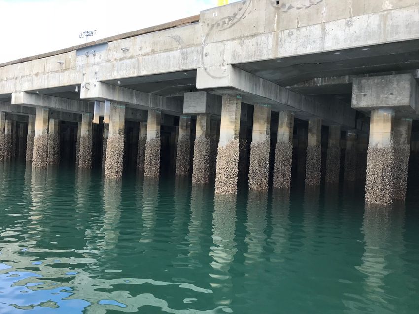
Figure 3: Concrete pilings
AF
R
D
December 2019 26Tacoma Harbor Deep Draft Navigation General Investigation
Phase I ESA
AL
N
FI
F
O
Figure 4: Industrial Facility with materials processing and loading to/from barge
T
7.0 SUMMARY OF FINDINGS AND CONCLUSIONS
AF
A Phase I ESA of the project area performed in conformance with the scope and limitations of ASTM
Standard E1527 – 13 occurred. A significant amount of existing data regarding contamination in
and around the Blair Waterway, along with recent dredge material characterization, provides a
thorough characterization for most of the project area. However, given the direct project footprint
R
overlap at the area of the Former Lincoln Ave Ditch and associated institutional controls,
supplemental information is needed for this specific area, including the nearby groundwater plume.
Additionally, the Corps needs to coordinate with the owner of the TrueGrit Site as the project
D
design progresses to ensure design compatibility for both projects. For the Occidental Chemical
Corporation site, confirmation during design is needed to ensure the groundwater plume is not
impacted by deepening activities
December 2019 27Tacoma Harbor Deep Draft Navigation General Investigation
Phase I ESA
APPENDIX A
A summary of sites near Blair Waterway with a known or suspected release of contaminants to
groundwater is provided in the table below.
Cleanup Facility
Cleanup Site Name Address City Site Status
Site ID Site ID
Awaiting
604 37982391 Clean Care Corp 1510 Taylor Wy Tacoma Cleanup
Awaiting
12552 14814 Gardner-Fields, Inc 2132 Taylor Way Tacoma Cleanup
AL
CC-
EMERALD SERVICES 1825 Alexander O&M/Monitorin
12490 82621489 INC ALEXANDER AVE Ave Tacoma g
ATOFINA CHEM 3009
TAYLOR WAY LOG CC-Perf.
N
3635 1219 YARD 3009 Taylor Way Tacoma Monitoring
1920 PORT OF
FI
TACOMA ROAD 1920 Port Of
3801 30005 TACOMA Tacoma Rd Tacoma Cleanup Started
Alexander Avenue
Petroleum Tank
743 1377 Facilities 709 Alexander Ave Tacoma Cleanup Started
F
Burlington
Environmental LLC 1701 E Alexander
O
3406 1233 Tacoma Ave Tacoma Cleanup Started
Pacific Functional 2244 Port Of
4329 1239 Fluids LLC Tacoma Tacoma Rd Tacoma Cleanup Started
Petroleum Reclaiming
T
3255 1245 Service Inc 3003 Taylor Way Tacoma Cleanup Started
4215 Sr 509 E
AF
3642 1215 Portac Inc Tacoma Frontage Rd Tacoma Cleanup Started
PROLOGIS
DEVELOPMENT
2240 1770486 SERVICES INCORPORAT 2000 Taylor Way Tacoma Cleanup Started
3438 68593938 SSA Containers Inc 3320 Lincoln Ave E Tacoma Cleanup Started
R
SUPERLON PLASTICS
2096 2776343 CO INC 2116 Taylor Way Tacoma Cleanup Started
D
Tacoma Port Earley 401 Alexander Ave
2395 9762715 Business Center Business Center Tacoma Cleanup Started
TACOMA PORT OF -
2215 38 Kaiser 3400 Taylor Way Tacoma Cleanup Started
TAYLOR WAY &
ALEXANDER AVE FILL 1500 Block Taylor
4692 1403183 AREA Way E Tacoma Cleanup Started
USG Taylor Way Plant
5003 1260 Site 2301 Taylor Way Tacoma Cleanup Started
December 2019 28Tacoma Harbor Deep Draft Navigation General Investigation
Phase I ESA
Cleanup Facility
Cleanup Site Name Address City Site Status
Site ID Site ID
OCCIDENTAL
4326 1212 CHEMICAL CORP 605 Alexander Ave Tacoma Cleanup Started
1110 E Alexander
1294 1206878 Tru-Grit Abrasives Inc Ave Tacoma Cleanup Started
3405 1220 ARKEMA INC 2901 Taylor Way Tacoma Cleanup Started
2407 Port Of CC-Perf.
3075 1211 MURRAY PACIFIC 2 Tacoma Rd Tacoma Monitoring
CASCADE POLE MCF 1002 Port Of
3254 1242 SITCUM Tacoma Rd Tacoma Cleanup Started
AL
US ARMY WSMC Pier 401 E Alexander
1750 54221181 23 Ave Tacoma Cleanup Started
Glenn Springs Holdings
4330 1246 Inc 709 Alexander Ave Tacoma Cleanup Started
N
Pier 4 Port Of
12597 6505 Pier 4 Port of Tacoma Tacoma Rd Tacoma Tracked by EPA
PUYALLUP LAND 250-368 Alexander
FI
113 212 SETTLEMENT E Ave E Tacoma Tracked by EPA
PUYALLUP LAND
653 213 SETTLEMENT F 3100 Taylor Way Tacoma Tracked by EPA
401 Alexander Ave
F
Shoreline
3363 8632033 PIER 24-25 Sediments Tacoma Tracked by EPA
COMMENCEMENT BAY Commencement
O
3032 42 NEARSHORE TIDEFLATS Bay Tacoma Cleanup Started
TACOMA PORT Awaiting
12401 5147833 SITCOM PLAZA 1 Sitcom Plaza Tacoma Cleanup
CC-
T
TACOMA PORT OF 802 O&M/Monitorin
7616 63973251 PORT CENTER RD 802 Port Center Rd Tacoma g
AF
AUTO WAREHOUSING
6974 97814788 CO TACOMA 3715 E West Rd Tacoma Cleanup Started
9215 44261344 CENEX AG INC 1801 Taylor Way Tacoma Cleanup Started
GP GYPSUM CORP 1240 E Alexander
6095 44479366 TACOMA PLANT Ave Tacoma Cleanup Started
R
J L DARLING 2212 Port Of
9393 47969128 CORPORATION Tacoma Rd Tacoma Cleanup Started
D
TACOMA CITY FIRE
5965 36991327 STATION 12 2316 E 11th St Tacoma Cleanup Started
EPA ID: STERICYCLE 1701 E ALEXANDER
- 1100143282 ENVIRONMENTAL AVE TACOMA, WA
45 SOLUTIONS 98421 Tacoma
EPA ID: 1825 E ALEXANDER
- 1100006205 EMERALD SERVICES AVE TACOMA, WA
88 98421 Tacoma
December 2019 29Tacoma Harbor Deep Draft Navigation General Investigation
Phase I ESA
REFERENCES
Corps, 1993. See reference citation in main FS report
Czuba et. al., 2010. See reference citation in main FS report
Dames and Moore, 1981. See reference citation in main FS report
EarthCorps. 2019. Commencement Bay.
AL
https://www.earthcorps.org/our-story/key-initiatives/commencement-bay/. Accessed
May 2019.
Ecology, 2019a. Environmental Covenants List.
N
https://apps.ecology.wa.gov/tcpwebreporting/reports/covenants?SiteName=Commence.
Accessed May 2019.
FI
Ecology (Washington Department of Ecology). 2019. Puget Sound Nutrient Reduction Project.
https://ecology.wa.gov/Water-Shorelines/Puget-Sound/Helping-Puget-Sound/Reducing-
Puget-Sound-nutrients/Puget-Sound-Nutrient-Reduction-Project.
Ecology, 2019b. Tacoma Smelter Plume Project. https://ecology.wa.gov/Spills-
F
Cleanup/Contamination-cleanup/Cleanup-sites/Toxic-cleanup-sites/Tacoma-smelter.
Accessed August 2019.
O
Ecology. 2019c. Toxic Cleanup Program Web Reporting.
https://fortress.wa.gov/ecy/tcpwebreporting/Default.aspx.
Accessed May 2019.
T
EPA (Environmental Protection Agency), 2004. Five Year Review Report, Commencement Bay
Nearshore/Tideflats Superfund Site, Tacoma, WA. EPA Region 10. December 29, 2004.
AF
EPA, 2014. Fourth five-year review report for Commencement Bay Nearshore/Tideflats Superfund
Site, Pierce County, Washington. Prepared by U.S. Environmental Protection Agency, Region
10. Seattle, Washington. December 1, 2014.
R
EPA. 2015. Envirofacts. http://www.epa.gov/enviro/index.html. Accessed May 2019.
Floyd Snider. 2016. Pier 4 Phase I Removal Action Project Time Critical Removal Action Completion
D
Report. July 2016.
Google Earth Pro. 2019. Accessed May 2019.
NOAA’s Office of Coast Survey. 2019. Historical Map & Chart Collection.
https://historicalcharts.noaa.gov. Accessed May 2019.
Puyallup River Watershed Council. 2014. Puyallup River watershed assessment (draft). Watershed
Assessment Committee. February 2014.
December 2019 30Tacoma Harbor Deep Draft Navigation General Investigation
Phase I ESA
Snover AK, Mote PW, Whitely Binder L, Hamlet AF, Mantua NJ, 2005. Uncertain future: climate
change and its effects on Puget Sound. A report for the Puget Sound Action Team by the
Climate Impacts Group. Center for Science in the Earth System, Joint Institute for the Study
of the Atmosphere and Oceans, University of Washington, Seattle, WA.
US Climate Data. 2019. Climate Tacoma-Washington.
https://www.usclimatedata.com/climate/tacoma/washington/united-states/uswa0441.
Accessed May 2019.
Washington Geological Information Portal. 2019. https://geologyportal.dnr.wa.gov/. Accessed
October 2019.
AL
SIGNATURE & QUALIFICATION PAGE
N
I declare that, to the best of my professional knowledge and belief, I meet the definition of
Environmental Professional as defined in 312.10 of 40 Code of Federal Register (CFR) 312 and the
ASTM Standard.
FI
I have the specific qualifications, based on education, training, and experience to assess a property
of the nature, history, and setting of the Property. I have developed and performed the Phase I ESA
in conformance with the ASTM and CERCLA standards and practices set forth in 40 CFR 312 and the
ASTM standard.
F
O
PREPARED BY:
T
AF
KRISTEN KERNS
Toxicologist
R
D
December 2019 31Tacoma Harbor Deep Draft Navigation General Investigation
Phase I ESA
ASSESSORS PROFESSIONAL EXPERIENCE
Education:
Bachelors of Science, Environmental Science, Western Washington University
Masters of Science, Environmental Health, University of Washington
Brief Summary of Relevant Experience:
Kristen has over 10 years of experience working on environmental restoration and remediation
sites. Her areas of expertise include human health risk assessment and remediation of
contaminated sediment sites. She has worked on all phases of remediation projects from
AL
preliminary investigation through construction and long term monitoring. Kristen has completed
numerous Phase I environmental site assessments, including those for other deep draft navigation
projects.
N
FI
F
O
T
AF
R
D
December 2019 32Tacoma Harbor Deep Draft Navigational General Investigation
Saltchuk Beneficial Use Site
Tacoma, Washington
PHASE I
AL
ENVIRONMENTAL SITE ASSESSMENT
N
FI
F
O
-------------------------------------------------------------------------------------------------------------------------------------------------- -------------
T
AF
December 2019
R
D
Prepared By
U.S. Army Corps of Engineers
Seattle District
Environmental Engineering & Technology Section
---------------------------------------------------------------------------- ----------------------------------------------------------------------------- ------This page intentionally left blank
AL
N
FI
F
O
T
AF
R
DTacoma Harbor Deep Draft Navigation General Investigation
Phase I ESA
TABLE OF CONTENTS
ACRONYMS & ABBREVIATIONS ........................................................................................................................................ ii
1.0 INTRODUCTION ............................................................................................................................................................. 3
1.1 Purpose..................................................................................................................................................................... 3
1.2 Description of the Project Area and Proposal for Federal Action .................................................... 3
1.3 Scope of Work ........................................................................................................................................................ 3
2.0 SITE DESCRIPTION & PHYSICAL SETTING ........................................................................................................ 5
AL
2.1 General Location ................................................................................................................................................... 5
2.2 Site Description ..................................................................................................................................................... 6
2.3 Hydraulics and Geomorphology .................................................................................................................... 6
2.4 Regional Climate ................................................................................................................................................... 6
2.5 Water Quality and Salinity................................................................................................................................ 6
N
3.0 ENVIRONMENTAL DATA BASE REVIEW ............................................................................................................ 7
3.1 Regulatory Agency Databases Records Search ........................................................................................ 7
3.2 Known Environmental Conditions ..............................................................................................................10
FI
4.0 PROPERTY HISTORY .................................................................................................................................................10
4.1 Property History .................................................................................................................................................10
4.2 Aerial Photographs and Maps .......................................................................................................................12
4.3 Records Review...................................................................................................................................................16
F
5.0 ADJOINING PROPERTY .............................................................................................................................................16
O
6.0 RESULTS OF VISUAL RECONNAISSANCE .........................................................................................................16
7.0 SUMMARY OF FINDINGS AND CONCLUSIONS................................................................................................18
Appendix A ...............................................................................................................................................................................19
T
REFERENCES ..........................................................................................................................................................................20
SIGNATURE & QUALIFICATION PAGE ..........................................................................................................................22
AF
ASSESSORS PROFESSIONAL EXPERIENCE .................................................................................................................23
R
D
December 2019 Page iTacoma Harbor Deep Draft Navigation General Investigation
Phase I ESA
ACRONYMS & ABBREVIATIONS
ASTM American Society for Testing and Materials
BT Bioaccumulation Trigger
CERCLA Comprehensive Environmental Response, Compensation, and Liability Act
CERFA Community Environmental Response Facilitation Act
Corps U.S Army Corps of Engineers, Seattle District
cPAHs Carcinogenic Polycyclic Aromatic Hydrocarbons
CY Cubic Yards
AL
DO Dissolved Oxygen
Ecology Washington Department of Ecology
EPA Environmental Protection Agency
ESA Environmental Site Assessment
GI General Investigation
N
HTRW Hazardous, Toxic, or Radioactive Waste
MLLW Mean Lower Low Water
MTCA Model Toxics Control Act
FI
NPL National Priorities List
OU Operable Unit
PCBs Polychlorinated Biphenyls
RCRA Resource Conservation and Recovery Act
REC Recognized Environmental Conditions
F
RI Remedial Investigation
ROD Record of Decision
O
SL Screening Level
TSS Total Suspended Solids
T
AF
R
D
December 2019 Page iiTacoma Harbor Deep Draft Navigation General Investigation
Phase I ESA
1.0 INTRODUCTION
This Phase I Environmental Site Assessment (Phase 1 ESA) is part of the Tacoma Harbor Deep Draft
Navigation General Investigation (GI). The U.S. Army Corps of Engineers, Seattle District (Corps)
has prepared a final Integrated Feasibility Report and Environmental Assessment, which
documents the process of developing potential solutions to evaluate the environmental impact of
deepening the Blair Waterway. A critical part of the feasibility analysis is the evaluation of known
and suspected hazardous, toxic, or radioactive waste (HTRW) conditions with potential to impact
project planning, design, and implementation. This Phase 1 ESA identifies all known and suspected
HTRW releases, and focuses only on the Saltchuk beneficial use site. A separate Phase I ESA for
AL
Blair Waterway is complete.
1.1 Purpose
The purpose of conducting this Phase 1 ESA is to determine the environmental condition of the
N
proposed project area. This ESA fulfils the requirements of the Comprehensive Environmental
Response, Compensation, and Liability Act (CERCLA) as amended by Community Environmental
Response Facilitation Act (CERFA). This report identifies known and potential sources of
FI
environmental risk or liability on the proposed project site, and in the surrounding areas. This
information will assist the Corps’ design team to manage and avoid HTRW hazards at the project site.
1.2 Description of the Project Area and Proposal for Federal Action
F
The Saltchuk beneficial use site occupies approximately 64 acres acres in the northeast portion of
Commencement Bay. The site is located southwest of Marine View Drive, north of the limit of
O
sediment placement extending to between approximately -35 and -50 feet MLLW, east of the
marina, and west of the limit of the Port owned property. The project will improve over 2,000
linear feet of shoreline. Historically, the area stored logs, and woody debris covers approximately
13% (8acres) of the 64 acre site. Existing site elevations range from about +10 feet MLLW to about
-50 feet MLLW. Sections of the site are to be filled to a depth of -10 feet to -4 feet MLLW with
T
dredged material from Blair Waterway.
AF
1.3 Scope of Work
The scope of work for this assessment was in general accordance with the ASTM International
(ASTM) Standard Practices for Environmental Site Assessments: Phase I Environmental Site
Assessment Process (ASTM E1527 - 13). These methodologies are described as representing good
commercial and customary practice for conducting a Phase I ESA of a property to identify
R
recognized environmental conditions (RECs). The project effort includes the following tasks:
• Conduct a record search and review all reasonably attainable federal, state, and local
D
government information and records to determine possible onsite sources of hazardous
substances and environmental condition of the project area.
• Review of all reasonably attainable federal, state, and local government records of adjacent
facilities with the potential to release contamination to determine possible offsite sources of
hazardous substances.
• Analysis of historical data on prior uses of the project site(s) and the surrounding area.
• Interviews with adjacent property owners and/or tenants or other knowledgeable sources.
• Visual site inspection of the project area to identify possible hazardous substance sources.
December 2019 Page 3Tacoma Harbor Deep Draft Navigation General Investigation
Phase I ESA
• Identify contamination sources using data gathered and evaluate what risk they pose and the
effect to the categorization of the environmental condition of the project area.
• Identify all ongoing actions that may affect the environmental conditions of the project area.
• Determine the environmental condition of the project area.
• Determine the extent to which recognized environmental conditions may impact, or pose a risk
to, the proposed project
The scope of this report did not include an audit of environmental regulatory compliance issues or
permits, wetland delineation, or collection and testing of environmental samples, including those
for radon gas, lead-based paint, polychlorinated biphenyls (PCBs), asbestos, soil, and/or
AL
groundwater condition.
N
FI
F
O
T
AF
R
D
December 2019 Page 4Tacoma Harbor Deep Draft Navigation General Investigation
Phase I ESA
2.0 SITE DESCRIPTION & PHYSICAL SETTING
2.1 General Location
The Saltchuk beneficial use site is located in the northeast portion of Puget Sound’s Commencement
Bay, at Tacoma, Washington. The site is located north of the federally authorized Tacoma Harbor
navigation project (Figure 1). The Tacoma Harbor federal navigation project consists of Hylebos
Waterway, Blair Waterway, two training walls at the mouth of the Puyallup River, and the City
Waterway (now called Thea Foss Waterway). Action associated with the Tacoma Harbor Deep
Draft Navigation GI is limited to the boundaries of the Blair Waterway and to the boundaries of the
beneficial use site to place sediment dredged from Bair Waterway. The focus of this Phase I is
AL
limited to the Saltchuk beneficial use site because the Blair Waterway is discussed in a separate
Phase I analysis.
N
FI
F
O
T
AF
R
D
Figure 1: Project Location
December 2019 Page 5You can also read