TAMSAT: LONG-TERM RAINFALL MONITORING ACROSS AFRICA - Ross Maidment, Emily Black, Matthew Young and Dagmawi Asfaw - 13th ...
←
→
Page content transcription
If your browser does not render page correctly, please read the page content below

TAMSAT: LONG-TERM RAINFALL
MONITORING ACROSS AFRICA

 Ross Maidment, Emily Black, Matthew
          Young and Dagmawi Asfaw
    TAMSAT, University of Reading

                      Helen Greatrex
           IRI, Columbia University    13th EUMETSAT User Forum in Africa
                                             24th-28th September, 2018
TAMSAT

The TAMSAT (Tropical Applications of Meteorology using SATellite and ground-
based observations) group, based in Reading (UK), have provided locally calibrated
satellite-based rainfall estimates for Africa since the 1980s.

Such data are vital for many applications, in particular rainfall monitoring and
assessment of long-term rainfall change across Africa.

TAMSAT have co-operated with numerous African meteorological services over the
years, building up strong relationships, through both regional workshops and
students taking MSc and PhD courses at Reading’s Meteorology Department.

In this presentation, we present an overview of TAMSAT rainfall products and other
areas of development within the group and the wider Earth Observation Division.
TAMSAT Estimation Method

                      The TAMSAT rainfall estimation
                      approach is based on Meteosat Thermal
                      Infra-Red imagery to identify precipitating
                      cumulonimbus clouds (deep convection)
TAMSAT Estimation Method

TAMSAT rainfall estimates are based on two inputs:
       • Meteosat thermal infrared imagery, used to create cold cloud duration
           (CCD) maps
       • Rain gauges, used to calibrate the CCD

                                                                Main assumptions

                                                      Case A: Clouds with tops colder than the
                                                      optimum temperature threshold (Tt) are
                                                      assumed to be raining

                                                      Case B: Clouds with tops warmer than Tt
                                                      are assumed not to be raining

CCD maps are calculated based on the total duration the cloud top temperature is
colder than a prescribed temperature threshold (Tt)
Rainfall is assumed to be a linear function of CCD: Rain=a0 + a1*CCD
Using historical data, Tt, a0 and a1 are all estimated during the calibration process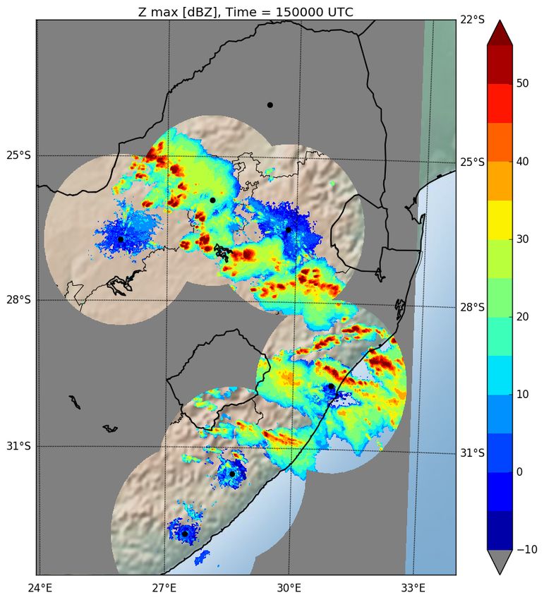
Cold Cloud Duration (CCD)
Link between convective rainfall and IR satellite imagery
Example: 12th Nov 2016 over South Africa

                           RADAR

Figure courtesy of
Dr Will Keat (University
of Reading)

Thanks to SAWS for
providing the radar data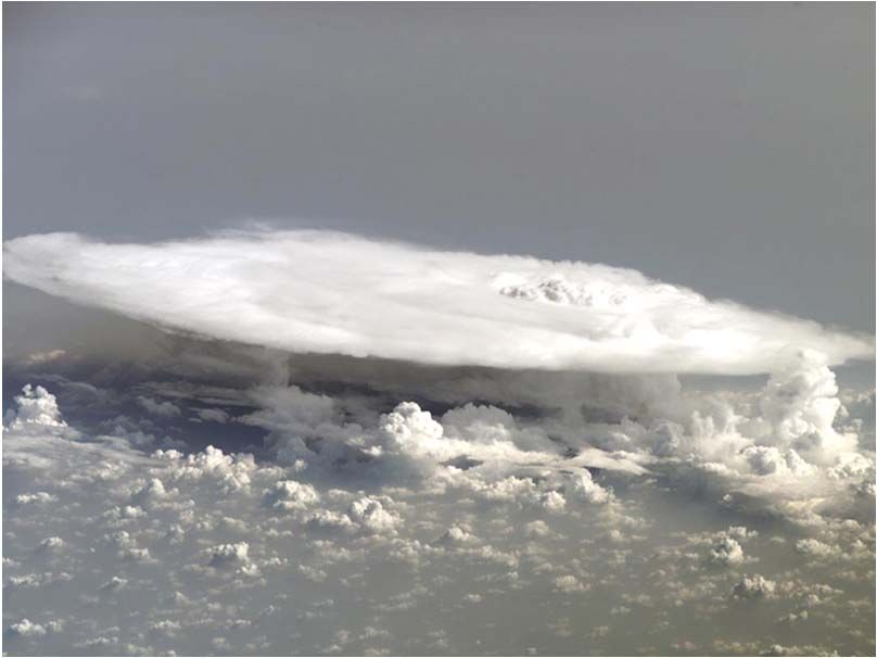
Link between convective rainfall and IR satellite imagery
Example: 12th Nov 2016 over South Africa

                                 -75 ̊C!!!

                               RADAR
Figure courtesy of
Dr Will Keat (University
of Reading)                  SEVIRI TIR
                             image
Thanks to SAWS for
providing the radar data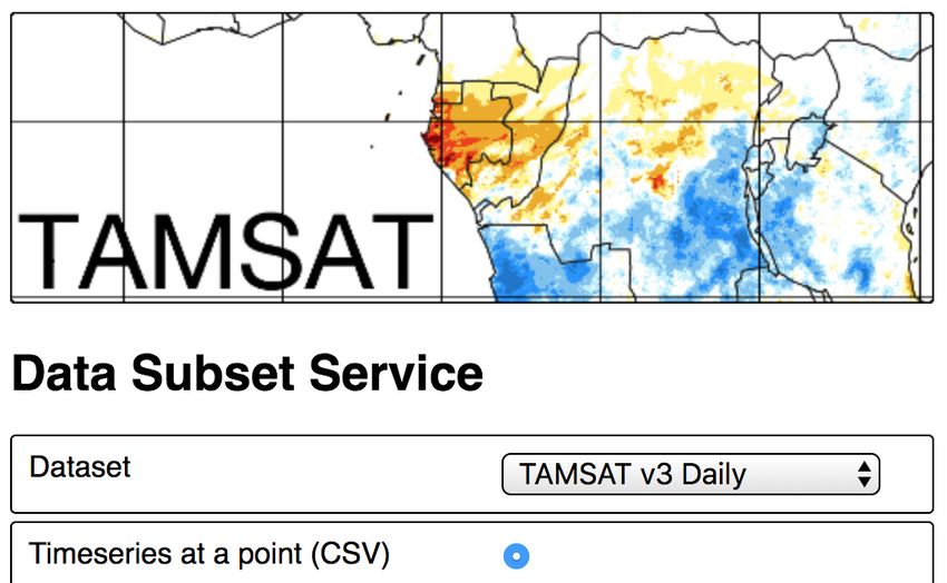
TAMSAT Version 3.0
Operational since Jan 2017

 Products

  Primary product                     Pentadal Estimates

                            Daily Estimates         Dekadal Estimates

                                                    Monthly Estimates
 Derived products          (disaggregated,
                         based on daily CCD)       Seasonal Estimates

                                                       (aggregated)

Summary
   • Africa-wide estimates at 4 km resolution
   • 1983 to present, 2-day latency
   • Available from www.tamsat.org.uk (also available on the FEWS Net early
     warning explorer, IRI Data Library and soon to be on EUMETCast )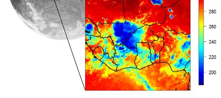
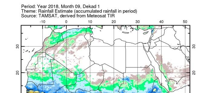
TAMSAT Estimation method:
1st dekad September 2018 (1st-10th rainfall total)
TAMSAT Data Subsetting Tool
Users can extract data for any region/time period

                                                Will be live on the
                                                TAMSAT website
                                                    from early
                                                   November!
TAMSAT Data
Strengths and weaknesses
Strengths • Longevity (+35 years)
• Available at the daily time-step with 2-day latency
• Temporally consistent
• Skillful estimates
• Suitable in many application, e.g.:
o drought monitoring
o famine early warning
o trend analysis
o risk assessment
o index insurance
Weaknesses • Underestimates intense rainfall events
• Can miss warm rain events (coastal/orographic)
• Persistent high level cirrus leads to overestimationOther developments [1]: merged satellite-gauge estimates Improve rainfall intensities by using auxiliary information TAMSAT estimates will tend to underestimate extreme rainfall events due to the lack of information in CCD on rainfall intensity. In TAMSAT, we have developed a novel method to incorporate contemporaneous gauge information to improve rainfall intensities, especially extreme events. Aim is to have an operational merged product by 2020.
Other developments [2]: TAMSAT-ALERT
Managing the risk of agricultural drought in Africa

 In Reading, in conjunction with Ghana Meteorological Agency, NCAS-Climate and
 NCEO, TAMSAT have developed a novel framework for agricultural decision support.

 TAMSAT-ALERT (the TAMSAT AgricuLtural EaRly warning sysTem) is an operational
 system providing early warning of meteorological risk to agriculture.

 TAMSAT-ALERT combines information on land surface properties, forecasts and
 historical weather with a well-established impact models to quantitatively assess the
 likelihood of adverse weather-related outcomes

                          See Matthew Young’s talk
                          on Thursday afternoon in
                              Session 6 (5 pm)
Summary of TAMSAT v3.0 rainfall product
Characteristic TAMSAT
Inputs TIR satellite imagery, gauge
Spatial Resolution 4km
Spatial Coverage Africa
Temporal Resolution Daily, 5-day, 10-day, monthly, seasonal
Start date Jan 1983
Latency 2 days
Strengths • Longevity (+35 years)
• Temporally consistent
• Daily timestep and short latency
• Good for drought monitoring, famine early warning,
index insurance
Looking to the future:
• Web-based data extraction tool ready in the next few months
• A complete rainfall dataset (1983-present) by Spring 2019
• An operational Africa-wide satellite-gauge merged product by 2020Other University of Reading satellite products:
Sea Surface Temperature
Climate Change Initiative/Copernicus Climate Change Service
ESA Climate Change Initiative (CCI)
• Climate Data Record (CDR) of SST
• Daily product, 0.05 degrees
• Sensors: ATSR, AVHRR
• 1980s to end-2016
• Expected release March 2019
Copernicus Climate Change Service (C3S)
• Interim Climate Data Record (ICDR) of SST
(extends SST-CCI CDR)
• Currently monthly updates ~1 year latency
• Will become short delay (daily update, < 1
week latency)
• Sensors: SLSTR, AVHRR Dr Owen Embury
o.embury@reading.ac.ukOther University of Reading satellite products:
Lake Surface Water Temperature
CGLOPS (Copernicus Global Land Service – Water )
Start Time step Latency Spatial RES Instrument N of lakes
10/04/2018 10 days 3-4 days 1/120 SLSTR on 1000 globally
(16/11/2016) degrees Sentinel3a
LSWT (K) LSWT UNC (K) Quality levels
Dr Laura Carrea
l.carrea@reading.ac.uk
5 4 3 2Final Remarks TAMSAT are keen to collaborate with Met Services or other organisations on the aspect of satellite rainfall estimation If you are interested in TAMSAT v3, TAMSAT research products, or any other products mentioned, please get in touch! Very happy to offer advice on both data access, usage and validation methodologies
TAMSAT skill
TAMSAT v3.0 is consistent with other datasets

  TAMSAT v3     CHIRPS v2      GPCC       V3.0 validation papers:

                                          Maidment et al., (2017)
                                          Nature Scientific Data

                                          Dinku et al., (2018)
                                          QJRS

                                          Ayehu et al., (2018)
                                          AMT
You can also read