Tanacross Project - January 2021 - Kenorland Minerals
←
→
Page content transcription
If your browser does not render page correctly, please read the page content below
Tanacross Project – January 2021
Disclaimer and Qualified Person
 The information contained herein, while obtained from sources which we believe are reliable, is not guaranteed as to its accuracy or completeness. References are made herein to historical information containing geologic and
 technical information. By its nature, this information cannot be verified. A Qualified Person has not verified the sampling, analytical, and test data underlying the historical information. Kenorland Minerals (The Company) has
 assumed that this historical information is accurate and complete in all material aspects and, while the Company has carefully reviewed all the available information, it cannot guarantee its accuracy and completeness. The
 content of this presentation is for information purposes only and does not constitute an offer to sell or a solicitation to purchase any securities referred to herein.

 This presentation contains "forward-looking statements" within the meaning of applicable securities legislation. These forward-looking statements are made as of the date of this presentation and the Company does not
 intend, and does not assume any obligation, to update these forward-looking statements, except as required by law.

 Forward-looking statements may include, but are not limited to, statements with respect to the future price of metals, the estimation of mineral resources, the realization of mineral resource estimates, the timing and amount
 of estimated future production, capital expenditures, success of exploration activities, permitting time lines, requirements for additional capital, government regulation of mining operations, environmental risks, unanticipated
 reclamation expenses, title disputes or claims, limitations on insurance coverage, the completion of transactions and future listings and regulatory approvals. In certain cases, forward-looking statements can be identified by
 the use of words such as "plans", "expects" or "does not expect", "is expected", "budget", "scheduled", "estimates", "forecasts", "intends", "anticipates" or "does not anticipate", or "believes", or variations of such words and
 phrases or state that certain actions, events or results "may", "could", "would", "might" or "will be taken", "occur" or "be achieved".

 Forward-looking information in this presentation includes, among other things, disclosure regarding: the Company’s mineral properties as well as its future outlook, statements with respect to the future price of minerals, the
 success of exploration activities, permitting time-lines, costs and expenditures requirements for additional capital, future listings and regulatory approval.

 In making the forward looking statements in this presentation, the Company has applied certain factors and assumptions that it believes are reasonable, including that there is no material deterioration in general business and
 economic conditions; that the supply and demand for, deliveries of, and the level and volatility of prices of the Company's primary metals and minerals develop as expected; that the Company receives regulatory and
 governmental approvals for its properties on a timely basis; that the Company is able to obtain financing for its properties on reasonable terms; that the Company is able to procure equipment and supplies in sufficient
 quantities and on a timely basis; that engineering and exploration timetables and capital costs for the Company's exploration plans are not incorrectly estimated or affected by unforeseen circumstances; that any
 environmental and other proceedings or disputes are satisfactorily resolved; and that the Company maintain its ongoing relations with its business partners.

 However, forward-looking statements involve known and unknown risks, uncertainties and other factors which may cause the actual results, performance or achievements of the Company to be materially different from any
 future results, performance or achievements expressed or implied by the forward-looking statements. Such factors may include, among others, actual results of current exploration activities; actual results of reclamation
 activities; future metal prices; accidents, labor disputes and other risks of the mining industry; delays in obtaining governmental or regulatory approvals or financing or in the completion of exploration activities, as well as
 those factors discussed in the section entitled "Risk Factors" in this presentation. Although the Company has attempted to identify important factors that could cause actual actions, events or results to differ materially from
 those described in forward-looking statements, there may be other factors that cause actions, events or results not to be as anticipated, estimated or intended. There can be no assurance that forward-looking statements will
 prove to be accurate, as actual results and future events could differ materially from those anticipated in such statements.

 Accordingly, readers should not place undue reliance on forward-looking statements. The Company does not undertake to update any forward-looking statements, except in accordance with applicable securities laws.

 Qualified Person’s Statement: Janek Wozniewski, P.Geo., OGQ, Exploration Manager for Kenorland, is the Qualified Person as defined by National Instrument 43-101, Standards of Disclosure for Mineral Projects. Mr.
 Wozniewski is responsible for the scientific and technical data presented herein and has reviewed and approved this project summary. Of note, historical results reported herein have not been verified by Kenorland personnel.
 Surface grab samples are selective by nature and are unlikely to represent average grades of the mineralization found on the property.
Porphyry Copper Deposits
                                                                                                          •   Permissive porphyry copper tracts of
                                                                                                              the Pacific Rim extend well into the
                                                                                                              Yukon and Alaska and host some of
                                                                                                              North America’s largest porphyry
                                                                                                              systems including Casino and Pebble
                                                                           Casino (74Ma)
                                                                               3.60Bt

                                                                                                          •   Many of these major porphyry
                                                                                                              copper deposits formed during the
                      Pebble (90Ma)
                         10.77Bt
                                                                                                              Late Cretaceous to Early Tertiary
                                                                                       Fish Lake (85Ma)
                                                                                             1.84Bt
                                      Tanacross Project
                                       Taurus (68-72Ma)                                                   •   The Tanacross Project sits within the
                                                                                                              Cretaceous arc of the Yukon-Tanana
     Malmyzh (98Ma)
         1.66Bt
                                                                                                              Terrane

                                                          Bagdad (71Ma)                                   •   Mineralized intrusions of the Taurus-
                                                              2.35Bt
                                                                                                              Bluff porphyry systems within the
                                                             Resolution (64Ma)
                                                                                                              Project area have geochronological
                                                                  1.79Bt                                      age dates placing them in the Late
                                                                                                              Cretaceous (68-72Ma)

                                                                                                                                                      3
Cretaceous Arc
                                         •   The Yukon-Tanana Uplands was

                                CANADA
                                             subject to extensive Cretaceous

                                  USA
                                             magmatism associated with both Cu-
                                             Au-Mo Porphyry systems and
                                             Intrusion Related Gold systems

                                         •   The Tanacross Project hosts a
                                             significant intrusive complex, with
                                             multiphase intrusive rocks and
                                             mineralization that spans a period of
                                             ~6 million years

                                              –   East Denison: 65.8-68.7 Ma
                                              –   Taurus: 69.8-71.5 Ma
                                              –   Bluff: 67.0-71.6 Ma
                 Tanacross Project

                                         •   A similar age of 74.4 Ma has been
                                             determined for mineralization at the
                                             giant Casino Cu-Au-Mo deposit
                                             within the arc

                                                                                 4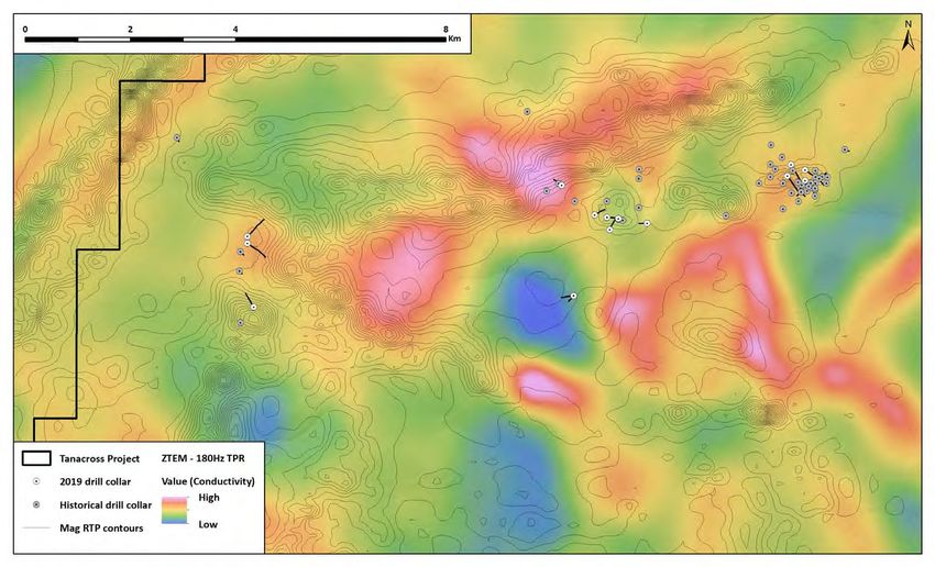
Yukon-Tanana Terrane Land Status
                                        •   The 100% Kenorland owned

                             CANADA
                                            Tanacross Project is a district scale

                               USA
                                            land package covering 45,900
                                            hectares on Alaska State owned land

                    Tanacross Project

                                        •   A winter trail accesses the property
                                            from the Taylor Highway east of Tok,
                                            Alaska

                                        •   Two gravel airstrips are also located
                                            on the property, suitable for small
                                            fixed-wing aircrafts

                                        •   All amenities required for
                                            exploration work can be sourced
                                            from nearby towns including Tok
                                            (100km to the west), and Fairbanks,
                                            Alaska which also has an
                                            international airport

                                                                                    5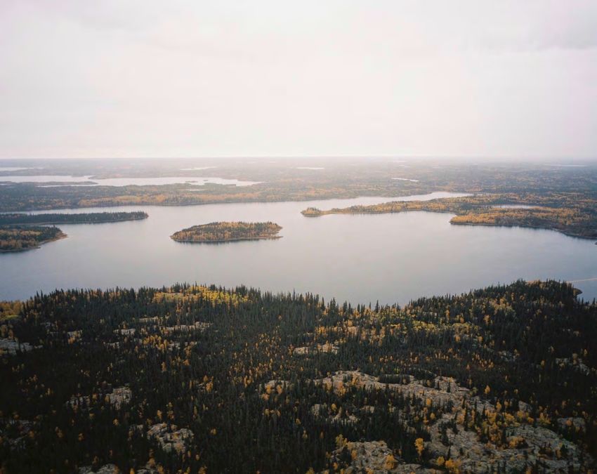
Yukon-Tanana Terrane Geology
                                                         •   The Tanacross Project is located within

                       CANADA
                                                             the Yukon-Tanana uplands, a

                         USA
                                                             geologically complex crustal block
                                                             which contains numerous mineral
                                                             systems

                                McCuaig, Hronsky, 2014   •   The property is located at the
                                                             intersection of two crustal scale fault
                                                             systems: the terrane parallel Big Creek
                                                             Fault (BCF) and the terrane
                                                             perpendicular Sixty Mile Pika Fault (SPF)

                                                         •   Globally, many significant porphyry Cu
                                                             deposits are spatially associated with
                                                             intersections between such arc-parallel
                                                             and arc-perpendicular structures

                                                         •   These structures are reactivated
                                                             repeatedly during arc-development as
                                                             conduits for mineralising fluids from the
                                                             mantle into the upper crust

                                                         •   Similar terrane scale controls believed
                                                             for the Casino Deposit; Big Creek Fault
                                                             (BCF) and Dip Creek Fault (DCF)
                                                             intersection

                                                                                                       6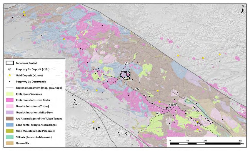
Yukon-Tanana Terrane Magnetics
                                                 •   Regional Magnetic surveys completed

                                        CANADA
                                                     by the Alaska Division of Geological and

                                          USA
                                                     Geophysical Surveys and NRCAN

                                                 •   Regional data shows the structural
                                                     complexity of Yukon Tanana Terrane,
                                                     characterised by broad NE-SW trending
                                                     fault zones bound by the Tintina Fault
                                                     to the north and the Denali Fault in the
                                                     south

                                                 •   These structures are known to be
                                                     associated with mineral systems
                                                     throughout the Yukon Tanana Terrane
                                                     with magmatic centers clustering
                                                     around the intersection of these
                                                     features

                   De
                     na
                          li F                   •   The Tanacross Project covers a cluster of
                              au
                                   lt                magnetic anomalies related to intrusive
                                                     centres associated with porphyry style
                                                     mineralisation

                                                                                            7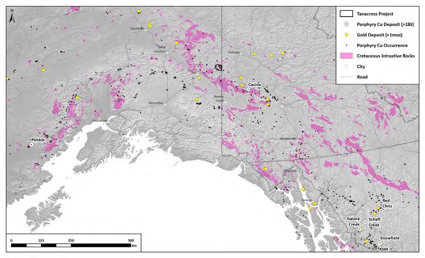
Yukon-Tanana Terrane Upward Continuation (UC) Magnetics
                                                    •     Upward continuation filter (10 km

                        CANADA
                                                          UC) used to examine regional and

                          USA
                                                          crustal scale magnetic signatures

                                                    •     Broad regional magnetic highs
                                                          associated with buried batholiths
                                                          under the Tanacross Project,
                                                          analogous to the Pebble deposit in
                                                          south-western Alaska

                                                                                               8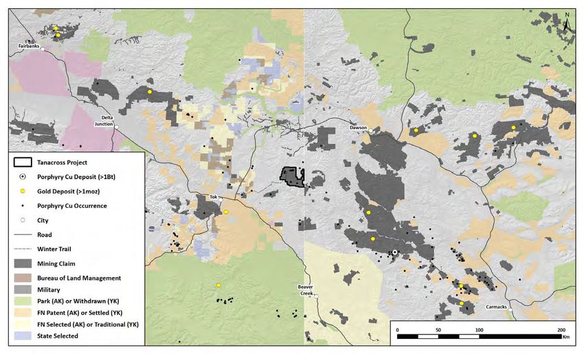
Yukon-Tanana Terrane Gravity
                                 •   Filtered and gridded Bouguer gravity

                        CANADA
                                     anomaly data compiled from the USGS

                          USA
                                     and NRCAN

                                 •   The Tanacross Project is located on a
                                     relative gravity low at the intersection
                                     of the SPF and BCF within a broader
                                     package of rocks exhibiting a moderate
                                     to high gravity response

                                 •   This depression in gravity signature is
                                     related to the lower density of
                                     voluminous felsic rocks associated with
                                     an intrusive complex

                                 •   The coincident UC magnetic anomaly
                                     with a broad gravity low covered by the
                                     project is characteristic of a large
                                     magmatic system which controls the
                                     porphyry centres within the project
                                     area

                                                                                9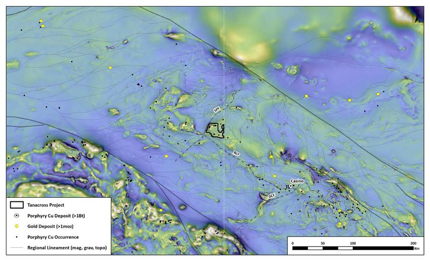
Yukon-Tanana Terrane Stream Sediment Geochemistry
• The Tanacross Project area is
CANADA
highlighted by a distinct cluster of
USA
• USGS RASS (Rock Analysis Storage System) stream sediment
samples
highly anomalous copper values in
regional stream sediment data
• Oxide residue analysis uses a weak oxalic acid digestion that
selectively targets Fe & Mn oxides which have scavenged
metals
• Samples were then analysed by optical emission spectroscopy • This map displays samples in Alaska
analysed using partial digest (oxalic
acid) and optical emission
spectroscopy, which correlates well
with streams draining known areas
of mineralization (the historical -80
mesh data was not as effective at
finger-printing known mineralization)
• Regional stream sediment data from
the Yukon shows more conventional -
80 mesh and modern ICP re-analysis.
This data highlights a similar regional
cluster of anomalism around the
Casino porphyry copper deposit
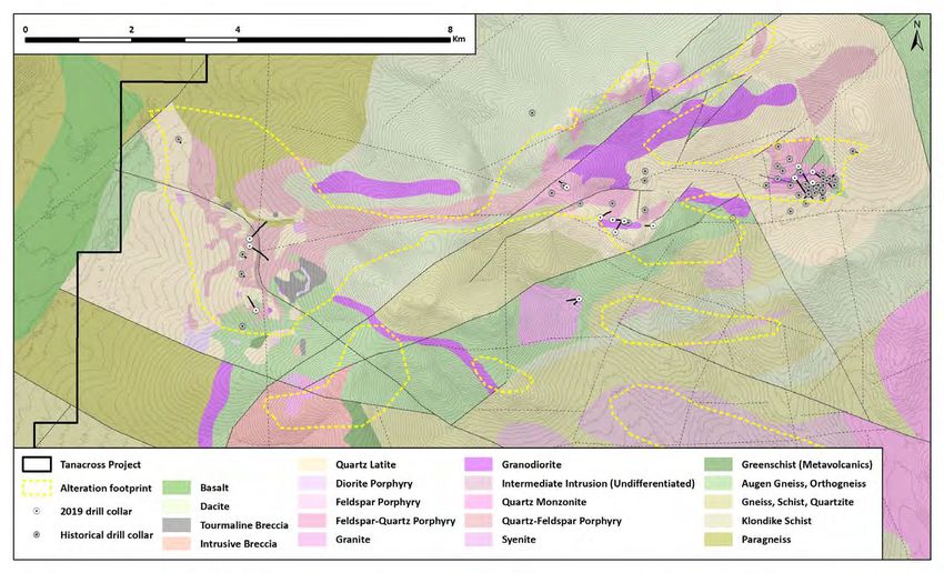
10Tanacross Geology and Alteration
• Project is underlain by a Late
Cretaceous – Early Tertiary multiphase
West Taurus intrusive complex emplaced into
metamorphic basement rocks of the
Yukon-Tanana and Klondike
East Taurus assemblages (schists and gneisses)
Bluff
• Extensive alteration mapped over 30
square kilometers, with three discrete
mineralized porphyritic centers
identified to date: East Taurus, West
Taurus, and Bluff
South Taurus
• Alteration proxy geochemistry map
(sericite index) confirms areas of
alteration using litho-geochemistry
Taurus - Bluff Alteration Footprint Comparison
East Denison
Pushbush Taurus - Bluff
Big Creek
Pebble El Salvador Butte Taca-Taca
10,910 Mt 3,836 Mt 5,220 Mt 3,086 Mt
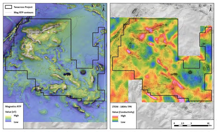
11Tanacross Geophysics Magnetics and ZTEM
• In 2019, Kenorland Minerals (funded
West Taurus by Freeport McMoRan) flew a
property-wide, 1,550 line kilometer
airborne ZTEM and magnetics survey
East Taurus with 400m line spacing
Bluff
• The deep-penetrating (up to 2km)
ZTEM system effectively maps
South Taurus
resistivity and conductivity contrasts
within the upper crustal rocks
• Hydrothermal clay and pyrite
alteration can be highlighted by
conductivity highs with such highs
East Denison correlating with areas of known
hydrothermal alteration such as East
Taurus, West Taurus, Bluff and South
Taurus
Pushbush
Big Creek
• The high resolution magnetic data
acquired with ZTEM also highlights
magnetic anomalies related to
porphyry centres in the target areas
12Tanacross Soil Geochemistry Copper and Porphyry Indicator
• Multi-element soil geochemistry has
defined several targets across the
Tanacross Project
– East Taurus: Cu-Mo-Au-Ag±Zn
– West Taurus: Cu-Mo-Au-Ag±Bi
– Bluff: Au-Sb-W±Cu-Mo-Tl
– South Taurus: Tl-Li-W±As-Sb-Zn
– Pushbush: Mo-Bi±Cu
– Big Creek: Cu-Zn-Pb±Au
• The multi-element geochemical
signatures may represent preserved
erosional levels within the
mineralized systems
– East and West Taurus: Near
surface porphyry mineralization
Au – Bluff and South Taurus: High
level or distal signatures,
additional proximal porphyry
mineralization at depth?
Mo Cu
13Taurus-Bluff Imagery
• The project area lies within
unglaciated terrain, with deep
residual soil and wind blown loess
West Taurus Camp cover across much of the landscape
• There is little to no outcrop exposure
over the majority of the property and
sub-crop is only present along more
prominent ridges at higher relief
Overlooking West Taurus Airstrip and Camp • A network of drill roads and two
airstrips have been established on
the property, reducing the need to
rely on helicopters to support drilling
around the Taurus-Bluff area
• The project hosts a fully operational
25-person camp located at the West
Taurus airstrip
14Taurus-Bluff Geology
• The Taurus-Bluff porphyry cluster occurs
over 12km of strike with three main
centers of alteration and mineralization
West Taurus (East Taurus, West Taurus, and Bluff)
East Taurus
• A total of 17,075m of drilling has
occurred on the property since 1971
and has been limited to these centers
• The majority of historical drilling was
South Taurus focussed at East Taurus, which hosts a
well mineralised, multiphase porphyry
Bluff Cu-Au-Mo-Ag system with a well
developed quartz stockwork and
potassic core surrounded and
overprinted by later quartz-sericite-
chlorite-pyrite alteration
• West Taurus host a Mo porphyry with
weak Cu and Au mineralisation
• Bluff is a very large (3km x 3km)
hydrothermal system however only
high-level quartz-sericite-pyrite (QSP)
alteration has been encountered to date
15Taurus-Bluff Magnetics
• In 2019, Kenorland Minerals (funded
by Freeport McMoRan) flew a
property-wide, 1,550 line kilometer
airborne ZTEM and magnetics survey
with 400m line spacing
• East Taurus, McCord Creek, West
Taurus, Denison and South Taurus
are all highlighted by magnetic highs
• Bluff is a magnetic low, possibly due
to widespread magnetite destructive
quartz-sericite alteration
• South Taurus is highlighted by the
largest discrete magnetic anomaly
and is spatially coincident with a very
large, 4km diameter, conductivity
anomaly which is associated with
hydrothermal alteration
16Taurus-Bluff ZTEM Conductivity 180 Hz TPR
• The property wide ZTEM data acquired
in 2019 displays contrasts in
conductivity within the project area
• Geological features such as faults and
hydrothermal alteration (clay and
pyrite) can increase the conductivity of
the bedrock which is mapped by the
ZTEM system
• Depending on alteration mineralogy
and levels of erosion on a hydrothermal
porphyry system varying levels of
conductivity can be expected
• The Bluff and East Taurus prospects
display moderate to strong conductivity
associated with QSP alteration of the
system, while West Taurus displays low
conductivity related to a quartz rich
leach cap
• The South Taurus Anomaly displays a
broad ring of strong conductivity
encompassing a circular magnetic
anomaly. These combined signatures
are likely related to peripheral QSP
alteration flanking the resistive and
magnetic core of the South Taurus
system
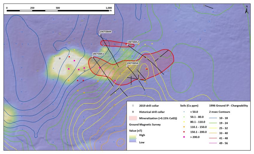
17East Taurus DDH Plan Map
• East Taurus hosts a well mineralized
multi-phase intrusive system with a
core of potassic alteration (kspar-
Cro
biotite-magnetite) and quartz
ss
Se
stockwork surrounded and
cti
overprinted by later quartz-sericite-
on
pyrite±chlorite-illite alteration
• There are at least 5 mineralized
phases of intrusive rocks recognized
at East Taurus
• The system extends for over 700m
east-west, 200-300m wide, and is
open along strike
n • 19ETD051 remains open to the west
ctio where the strongest copper in soils
e
gS
n could extend the East Taurus system
Lo
to >1km in strike length
Priority drill target: Step out drill hole
from 19ETD051 (102.0m @ 0.125% Cu,
0.171 g/t Au, 0.023% Mo), strong soil • The system conductive in ZTEM, is on
anomalism, moderate-strong the margin of an IP chargeability high
magnetics possibly associated with and is flanked with a strong magnetic
Kspar-bi-mt alteration anomaly extending to the west
18East Taurus Cross Section
• East Taurus hosts a well mineralized
multi-phase intrusive system with a
core of potassic alteration (kspar-
biotite-magnetite) and quartz
stockwork surrounded and
overprinted by later quartz-sericite-
pyrite±chlorite-illite alteration
• There are at least 5 mineralized
phases of intrusive rocks recognized
at East Taurus
• The system extends for over 700m
east-west, 200-300m wide, and is
open along strike
HOLE ID Length (m) Cu (%) Au (ppm) Mo (%)
19ETD051 412.37 0.107 0.115 0.015 • 19ETD051 remains open to the west
Including 102.00 0.125 0.171 0.023 where the strongest copper in soils
And Including 73.50 0.167 0.130 0.015 could extend the East Taurus system
to >1km in strike length
ZTEM Resistivity
HOLE ID Length (m) Cu (%) Au (ppm) Mo (%) Value (Ohms) • The system conductive in ZTEM, is on
08DDH040 232.56 0.311 0.247 0.036 the margin of an IP chargeability high
19ETD050 285.00 0.225 0.159 0.036 and is flanked with a strong magnetic
anomaly extending to the west
19East Taurus Long Section
• East Taurus hosts a well mineralized
multi-phase intrusive system with a
core of potassic alteration (kspar-
biotite-magnetite) and quartz
stockwork surrounded and
overprinted by later quartz-sericite-
pyrite±chlorite-illite alteration
• There are at least 5 mineralized
phases of intrusive rocks recognized
at East Taurus
• The system extends for over 700m
east-west, 200-300m wide, and is
open along strike
HOLE ID Length (m) Cu (%) Au (ppm) Mo (%)
HOLE ID Length (m) Cu (%) Au (ppm) Mo (%)
96DDH030 174.96 0.311 0.103 0.032 • 19ETD051 remains open to the west
19ETD051 412.37 0.107 0.115 0.015
96DDH037 186.54 0.230 0.075 0.029 where the strongest copper in soils
Including 102.00 0.125 0.171 0.023
And Including 73.50 0.167 0.130 0.015 could extend the East Taurus system
to >1km in strike length
ZTEM Resistivity
Value (Ohms) • The system conductive in ZTEM, is on
HOLE ID Length (m) Cu (%) Au (ppm) Mo (%) the margin of an IP chargeability high
96DDH032 208.48 0.233 0.136 0.032 and is flanked with a strong magnetic
Including 102.47 0.311 0.194 0.046 anomaly extending to the west
20East Taurus Mineralization and Alteration
19ETD050 @ 138m: Quartz-monzonite
porphyry, dark grey qtz stockwork veining
with K-spar alteration selvedges, strong
py-cpy disseminations
QTZ-PY-CPY-MO
19ETD050 @ 215m: Intrusion breccia,
dark grey qtz-py-cpy-mo veinlets, ,
sericite-chlorite-magnetite altered quartz-
latite clasts within strong K-spar altered
matrix
19ETD050 @ 227m: Quartz latite, py-cpy
vein, K-spar-biotite-sericite-chlorite
alteration
PY
CPY
From (m) To (m) Interval (m) Cu (%) Au (g/t) Mo (%)
19ETD050 130.50 136.50 (photo) 6.00 0.403 0.351 0.067
within 105.00 390.00 285.00 0.225 0.159 0.036
21West Taurus DDH Plan Map
• West Taurus hosts a significant
alteration system
– Centered on quartz-chlorite-
sericite-pyrite-magnetite with
local K-spar alteration containing
Circular geophysical feature: cored by qtz-mo±cpy stockwork veining
low magnetism and moderate (resistivity high, moderate
chargeability, flanked by increased chargeability)
chargeability, copper in soil
anomalism, and magnetism – Outward zoning into widespread
quartz-sericite-pyrite alteration
(conductivity high, chargeability
high)
• Mineralisation at West Taurus is hosted
within intrusion breccias with quartz
latite matrix
• Soils define a broad E-W ellipse (Cu > 50
ppm, Mo > 5 ppm) over an area of 2.0 x
1.0 km
• The system is centered around a
moderate chargeability anomaly (12-16
msec) surrounded by elevated
chargeability (20-26 msec) and
magnetic signature
22West Taurus Mineralization and Alteration
19WTD046 @ 68m: Quartz latite, dark
grey qtz stockwork veining, K-spar
selvedge grading to chlorite-sericite-
pyrite-magnetite alteration
19WTD046 @ 79m: Intrusion breccia,
dark grey qtz-mo stockwork veining,
chlorite-epidote-K-spar altered
19WTD046 @ 98m: Quartz latite, qtz-gar-
ep-mag-mal vein, quartz-sericite-chlorite
alteration
From (m) To (m) Interval (m) Cu (%) Au (g/t) Mo (%)
19WTD046 76.50 82.50 (photo) 6.00 0.050 0.055 0.021
within 1.52 197.50 195.98 0.047 0.047 0.013
23Bluff DDH Plan Map
• Bluff hosts a significant alteration
system characterized by widespread,
intense quartz-sericite-pyrite (QSP) ±
clay alteration, and lesser chlorite-
sericite, silicification, tourmaline and
rare K-spar- biotite alteration
• Unique to the Bluff area, are large
zones of intense tourmaline ± quartz
alteration as well as a ~1km diameter
tourmaline breccia pipe
• Widespread QSP ± clay and
tourmaline alteration suggests the
upper levels within a porphyry
hydrothermal system
• The large conductivity anomaly
imaged in the ZTEM data appears to
relate to this widespread alteration.
24Bluff Mineralization and Alteration
19BLD053 @ 268m: Feldpsar porphyry,
qtz-py-mo veinlet, quartz-sericite-pyrite
alteration selvedge
19BLD053 @ 630m: Paragneiss, py-mag-
tm veinlet, strong quartz-sericite-pyrite-
tourmaline alteration
19BLD053 @ 762m: Paragneiss, qtz-tm-py
veining, chlorite-sericite-illite-kaolinite
alteration selvedges
19BLD057 @ 808-816m: felsic intrusive with intense QSP alteration and dark grey
qtz-py “D” veining, increasing down hole, no notable assay results
25South Taurus Geophysics
Magnetics – Broad magnetic anomaly with a similar shape ZTEM 180 Hz – Conductive halo with more resistive core. ZTEM 30 Hz – Long wavelength (deep ~1.5km-2km)
and strength as East and West Taurus Conductivity associated with quartz-sericite-pyrite alteration conductivity anomaly, coincident with deeper magnetic high
26South Taurus Large Footprint
Plan view of Pebble ZTEM (same scale) • Basement gneiss and schists with
monzonite dykes (py-mineralized,
QSP altered) mapped at surface
– Magnetic high (oxidized
intrusive) may represent
uctiv
e unroofed porphyry center at
Cond yrite)
+p depth
(clay ion halo
r a t
alte
• Strong soil geochemical anomalism
(Tl-Li-W+/-As-Sb-Zn)
– Consistent with high level or
on
distal porphyry geochemical
ati
oc
signatures
L
on
cti
South Taurus ZTEM section (same scale)
Se
• Conductive halo (surrounding clay
and pyrite halo) centered on more
resistive, magnetic high feature
• Conductivity extending to depth of
ZTEM survey (~1.5-2km), similar to
many significant other porphyry
systems globally
27Tanacross 2021 Planned Work Programs
• High resolution drone magnetic
East Taurus
survey grid over East Taurus, West
Step-out drilling Taurus and South Taurus target areas
• Detailed soils and mapping over the
South Taurus target area
• Deep penetrating, high-power Titan
IP survey (2 x 5km lines) over South
Taurus
s • Diamond drilling: ~3,000m
L ine
n IP
it a
T
– Step out drilling at East Taurus
along mineralized system
Soils and Mapping
South Taurus – Initial drill testing of South
Grid mapping and XRF soil survey, Drone Magnetic Survey Taurus target area
IP survey, initial drill testing
28You can also read