The 1946 - 1956 Hydrographic Data Archive at the Institut für Meereskunde, Kiel, digitized - OceanRep
←
→
Page content transcription
If your browser does not render page correctly, please read the page content below
The 1946 - 1956 Hydrographic
                  Data Archive at the Institut
GEOMAR REPORT

                für Meereskunde, Kiel, digitized
                               A data-guide by
                              Thomas J. Müller
                   GEOMAR Helmholtz Centre for Ocean Research

                        Research cutter SÜDFALL
                        in the year 1946

                            Berichte aus dem GEOMAR
                    Helmholtz-Zentrum für Ozeanforschung Kiel

                                  Nr. 58 (N. Ser.)
                                          April 2021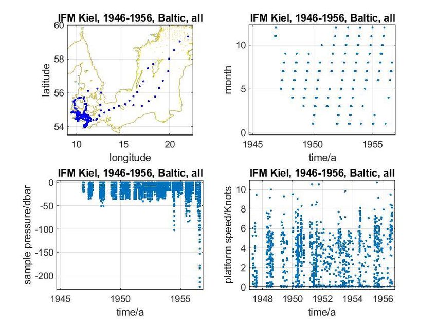
The 1946 - 1956 Hydrographic
Data Archive at the Institut für
 Meereskunde, Kiel, digitized
                A data-guide by
               Thomas J. Müller
    GEOMAR Helmholtz Centre for Ocean Research

         Research cutter SÜDFALL
         in the year 1946

            Berichte aus dem GEOMAR
    Helmholtz-Zentrum für Ozeanforschung Kiel

                   Nr. 58 (N. Ser.)
                           April 2021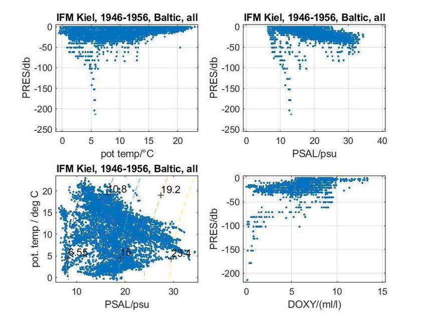
Das GEOMAR Helmholtz-Zentrum für Ozeanforschung Kiel          The GEOMAR Helmholtz Centre for Ocean Research Kiel
       ist Mitglied der Helmholtz-Gemeinschaft                     is a member of the Helmholtz Association of
           Deutscher Forschungszentren e.V.                                German Research Centres

Autor / Author:
Thomas J. Müller

GEOMAR Report
ISSN Nr.. 2193-8113, DOI 10.3289/GEOMAR_REP_NS_58_2021

Helmholtz-Zentrum für Ozeanforschung Kiel / Helmholtz Centre for Ocean Research Kiel
GEOMAR
Dienstgebäude Westufer / West Shore Building
Düsternbrooker Weg 20
D-24105 Kiel
Germany

Helmholtz-Zentrum für Ozeanforschung Kiel / Helmholtz Centre for Ocean Research Kiel
GEOMAR
Dienstgebäude Ostufer / East Shore Building
Wischhofstr. 1-3
D-24148 Kiel
Germany

Tel.: +49 431 600-0
Fax: +49 431 600-2805
www.geomar.de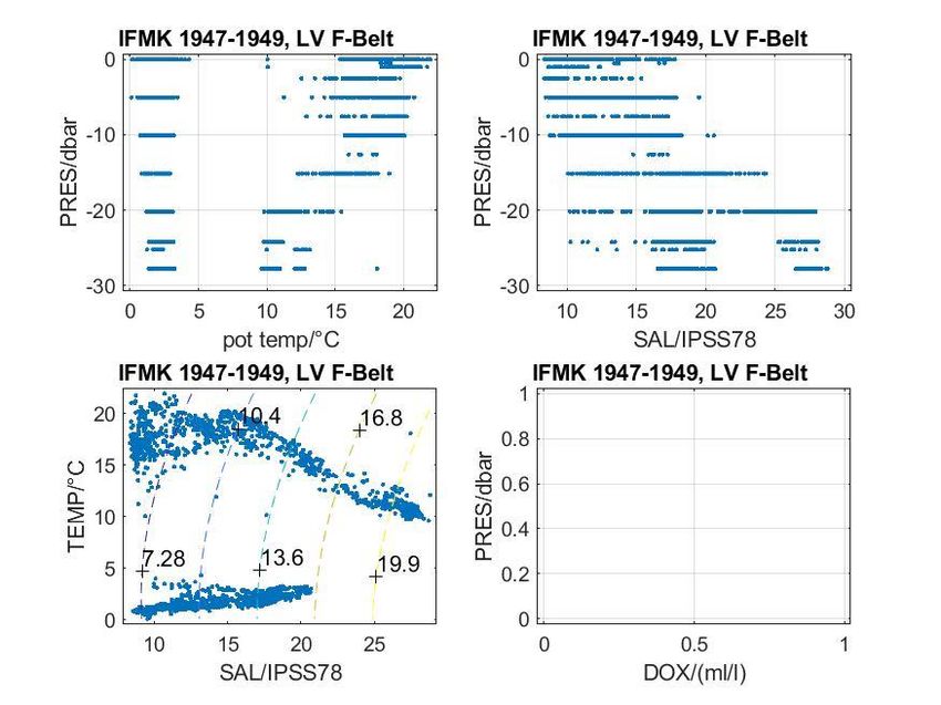
GEOMAR Helmholtz Centre for Ocean Research Kiel: The 1946 - 1956 hydrographic data archive……   -2-

                                         The 1946 - 1956
  Hydrographic Data Archive at the Institut für Meereskunde, Kiel,
                                               digitized
                                              A data-guide
                                                     by
                                           Thomas J. Müller
                       GEOMAR Helmholtz Centre for Ocean Research
Summary
This report is thought as a guide to early hydrographic log sheets of bottle data obtained by
the former Institut für Meereskunde, Kiel (IFMK, now integrated into GEOMAR) in the post-war
years 1946 to 1956, and which in summer 2018 when a building used by GEOMAR was to
clear were not available in digitized format at GEOMAR. The data mostly were taken by the
research cutter FK “Südfall” in the Baltic. It turned out that some of these data from 1950 to
1956 were available in digitized form at the on-line data bank of the International Council for
the Exploration of the Sea (ICES). Comparison with the original logged data sheets, however,
showed that they needed to be improved w/r to time and position and to be completed by
missing data. This report shortly describes the methods of sampling and measuring these old
data, and the processing steps applied to improve the data set by using the data log sheets
before archiving and submitting the now improved and complete data set to data centres for
archiving.
Zusammenfassung
In diesem Bericht werden hydrographische Daten des früheren Instituts für Meereskunde Kiel
(IFMK, jetzt integriert im GEOMAR), aus den Nachkriegsjahren 1946 bis 1956 beschrieben,
die während einer Aufräumaktion in einem bisher von GEOMAR genutzten Gebäude in Form
schriftlicher Datenprotokolle gefunden wurden, und die am GEOMAR bislang nicht in
digitalisierter Form vorlagen. Die Datensätze sind überwiegend in der westlichen Ostsee mit
dem Forschungskutter FK „Südfall“ gewonnen worden. Einige Daten von 1950 bis 19656
waren zwar on-line digital beim Internationalen Rat für Meeresforschung (ICES) in
Kopenhagen verfügbar. Durch Vergleich mit den jetzt gefundenen Daten-Protokollen stellte
sich jedoch schnell heraus, dass dieser bereits digitalisierte Datensatz hinsichtlich Zeit- und
Positionsangaben verbessert sowie fehlende Daten nachgetragen werden mussten. In diesem
Bericht werden Methoden zur Probennahme und Messung in der damaligen Zeit sowie Schritte
der Aufbereitung beschrieben, wie der bislang digital vorliegende Datensatz in der Qualität
verbessert und fehlende Daten ergänzt wurden, bevor sie nunmehr verbessert und vollständig
bei den relevanten Datenzentren zur Archivierung eingereicht wurden.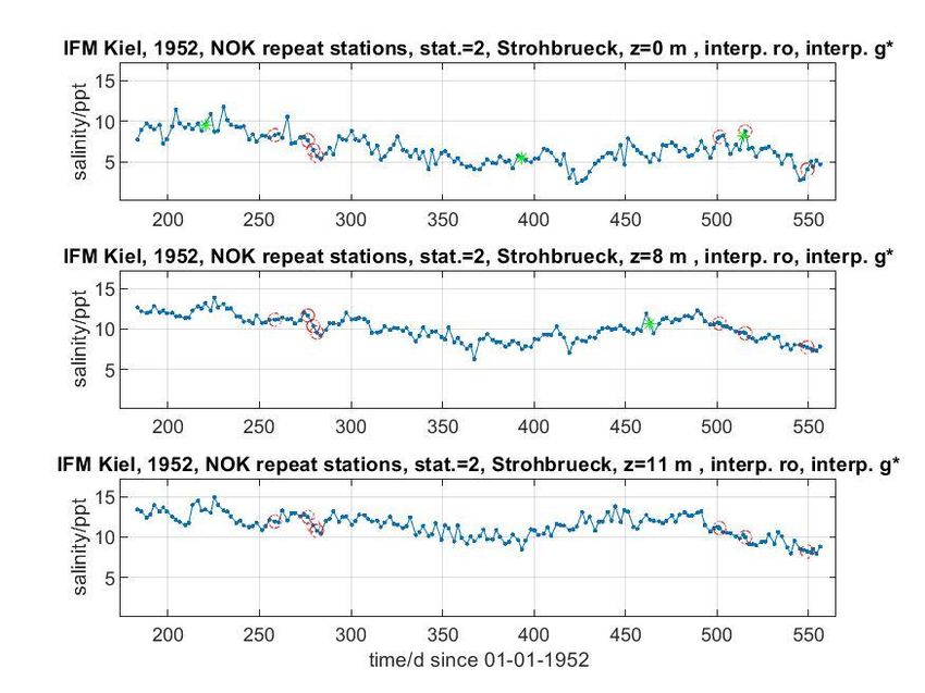
GEOMAR Helmholtz Centre for Ocean research Kiel: The 1946 - 1956 hydrographic data archive……   -3-

Contents                                                                                              page

   1    Background                                                                                    4
   2    Data description                                                                              5
   3    Methods of measurements                                                                       6
   4    Processing and Data Submission                                                                6
   5    Further Background Information                                                                9
   6    Acknowledgements                                                                              9
   7    References                                                                                    10
   8    Ships                                                                                         10
   9    Acronyms                                                                                      10

   Appendix 1: Cover of the Archive of the Institut für Meereskunde                                   11
   Appendix 2: Sampling and measurement methods applied                                               12
   Appendix 3.1: 1946 to 1956, Baltic Sea hydrographic data overview plots                            13
   Appendix 3.2: 1946 to 1956, Time Series Station “Boknis-Eck”                                       14
   Appendix 3.3: 1947 to 1949, German light vessel LV “Fehmarn Belt”                                  15
   Appendix 3.4: 1949 to 1950, German light vessel LV “Flensburger Förde”                             16
   Appendix 3.5: 1947 to 1949, coastal surface data off Bülk, Kiel Fjord                              17
   Appendix 3.6.1: 1947, surface data north of Iceland, “CV Alice Freymann”                           18
   Appendix 3.6.2: 1953, surface data North Sea to Iceland, “FSB Meerkatze”                           19
   Appendix 3.7: 1952 -1953, Kiel Canal, salinity time series, 11 stations                            20
GEOMAR Helmholtz Centre for Ocean Research Kiel: The 1946 - 1956 hydrographic data archive…… -4-
1. Background
In June 2018, GEOMAR needed to clear a building as by contract it would no longer being
used by GEOMAR. Since the early 80s, the then Institut für Meereskunde, Kiel (IFMK, now
integrated into GEOMAR), by the then three physical oceanography departments (PO) and
the meteorological department of the IFMK had been using it. In particular within the 15-
year long-term research programme SFB133, post docs and PhD students of the four
departments were jointly working there.
During a quick first inspection, it became clear, that copies of PO conducted old cruise data
were printed out on paper, and that while also some cruise relevant information like cruise
reports and station lists were found, none of the then typically used magnetic tapes or data
disks could be found as possible electronic storage media of the printed versions. Also,
within the now Physical Oceanography research unit (PO) of GEOMAR, it was known that
data of some of the SFB’s cruises and some about year-long time series data from moored
instruments were missing in the present PO data base (PO-DB).
With this background and under the pressure of a 14-day deadline, the responsible heads
of GEOMAR’s Research Division 1 and the PO Research Unit decided, that all rooms
including the roof floor next to the upper floor would be carefully inspected, aimed at
identifying and rescuing possibly so-far lost data. As I myself had been working next to the
then responsible scientists in that building in that time period, I was asked to take the lead.
The major goal was to identify data missing in the PO data base (PO-DB) from about 1957
on when post-war West Germany had begun to join international marine open ocean
research programmes like the International Geophysical Year (IGY). The aim was to
recover such data for the PO-DB, either from other data banks or by digitizing. Data not
being identified at any data centre would then eventually be digitized, archived at the PO
data base, and delivered to relevant data centres.
Surprisingly and completely unexpected, however, we also detected an early post-war
1946 to 1956 hydrographic data set in a single file with 25 logged handwritten and later
type-writer printed log sheets of hydrographic data, mostly from the Baltic Sea. The file’s
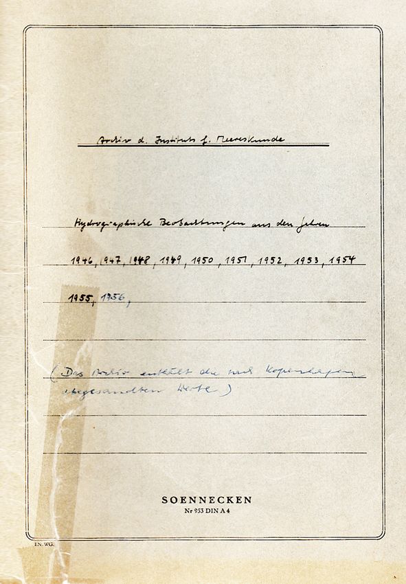
cover (App. 1) in the English translation reads
Archive of the Institut für Meereskunde
Hydrographic observations from the years 1946, 1947……1956
(The archive contains the values sent to Copenhagen)
The cover is not dated, nor is it signed. It is this archive that is dealt with in this data
guide. The 25 data sets were
• checked if the data indeed were available in digitized form at the on-line data
bank of the “International Council for the Exploration of the Sea” (ICES, with seat
in “Copenhagen”) as indicated on the cover, and eventually downloaded
• checked for completeness and eventually corrected w/r to accuracy in time,
latitude and longitude. Missing data were digitized for completion
• after correction and completion, all data were submitted to the data centre of the
ICES, to the Deutsches Ozeanographisches Datenzentrum DOD (at BSH), and to
the European project SeaDataCloud which supported the work
• In addition, relevant subsets were provided to the IOW in Rostock-Warnemünde,
Germany, the MRI in Reykjavik, Iceland, the FMRI in Thorshavn, Faroe Islands,
and to the LLUR through a cooperation of the LLUR, Flintbek, Germany with
GEOMAR (Prof. Bange, GEOMAR, pers. comm.)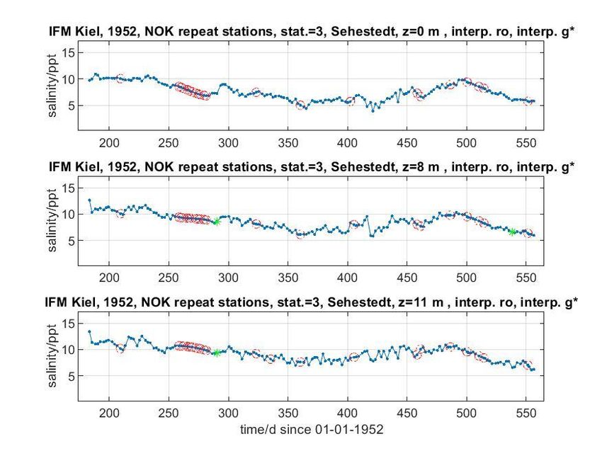
GEOMAR Helmholtz Centre for Ocean Research Kiel: The 1946 - 1956 hydrographic data archive……   -5-

2. Data description
The IFMK post-war hydrographic station data cover the almost 10-year time period from
November 1946 to August 1956. They were mostly taken in the Baltic Sea, but also during
a single cruise in the eastern German Bight in 1954. The ship used was the research cutter
FK “Südfall”, owned by the IFMK since 1946. Also, two cruises with other ships led to costal
seas around Iceland and the Faroe Islands while supporting German fishery protection
there.
Standard parameters measured were temperature and salinity, some in addition with
dissolved oxygen, few with phosphorus from phosphate, and very few with alkalinity pH.
Chlorophyll and other biological parameters were taken only during the single cruise in the
North Sea, and during one of the protecting fishery-activity. No nitrate nor silicate were
taken at all.
Of the 25 data log sets some were double or drafts, leaving 18 significant paper-based
data log files which maybe characterized in more detail:

        •   Baltic Sea, 1946 – 1956, this is the largest set, mostly from the Kiel Bight, but
            also from the Danish Belt Sea and from two hydrographic sections between Kiel
            and the Gotland Basin. Part of the subset from 1950 to 1956 could be
            downloaded from the ICES data bank.

        •   Baltic Sea light vessels: two sets of repeated station data on an irregular basis
            from two German light vessels that were operational in the Kiel Bight in these
            years: LV “Fehmarn Belt”, 1947-1949, and LV “Flensburger Förde”, 1949-1950.

        •   North Atlantic surface and / or near surface data taken during two cruises:
            (i) in 1947 on the German cargo vessel CV “Alice Freymann” while (probably)
            supporting fishery protection along the northern coast of Iceland.

            (ii) in 1953 on the fishery protection vessel FSB “Meerkatze” (in service 1950
            to 1974) from the northern North Sea to the Faroe Islands coastal waters around
            Iceland.

        •   Kiel Canal (NOK), 1952 to 1953, one year repeated quasi-synoptic salinity
            section, 164 repetitions at 2 d to 3 d repetition time, 11 stations at ca. 10 Km
            spacing, samples from the surface (0 m), the bottom (11 m), and in addition
            from 8 m depth at the eastern four stations where stronger vertical salinity
            gradients occur. The samples were taken by employees of the canal’s
            administration, and therefore one may speculate that IFMK probably just served
            with its expertise by measuring the salinity of the samples in the laboratory. No
            temperature data are listed in this set.

        •   North Sea, 1954, eastern German Bight off the coast of Schleswig-Holstein,
            a more biologically oriented cruise.
GEOMAR Helmholtz Centre for Ocean Research Kiel: The 1946 - 1956 hydrographic data archive……   -6-

     3.     Methods of measurements
           The data logs always give the date and almost always the time of the station. Also, the
           location is given with latitude and longitude, however only in very few cases the bottom
           depth. The precision of these meta data was
               • Date & time: in most cases logged up to minutes of an hour
               • Latitude and longitude: in most cases up to 1/10 of a minute (182 m in
                   latitude)

           Methods used to measure bottle parameters were standard at that time for the Baltic
           Sea with its strong vertical and horizontal gradients, and keywords are given for some
           parameters in two logs, originally in German (App. 2):
                  • Sampling depth was estimated from the hydrographic wire’s length while
                      fixing the bottle; sometimes, the combination of pressure protected and
                      unprotected reversing thermometers after Richter were used.
                  • Temperature was measured using protected reversing thermometers after
                      Richter, 0.01 °C
                  • Salinity was measured using a Zeiss refractometer, 0.05 ppt
                  • Dissolved oxygen was measured applying the Winkler method, 0.01 ml/l
                  • Phosphorus from phosphate was measured using Zeiss’ photometric
                       method, 0.1 mg/l. Phosphatic phosphorus in the hydro logs is given in mg/l,
                       and in the ICES downloaded data was converted to µmol/l. The conversion
                       factor is the inverse of the atomic molar mass of phosphorus, M(P) =
                       30.9737620 mg/µmol phosphorus. No other nutrients were measured
                  • pH is the negative decadic logarithm of the concentration of hydrogen ions
                       in the sample
                  • Chlorophyll a at the sea surface was measured during the 1953 cruise on
                       the FSB Meerkatze
                  • Chlorophyll a together with other biological and chemical parameters on
                       stations were measured during the 1954 North Sea cruise

4.   Processing and Data Submission
     4.1      General
                    First, all 25 paper-based logs were e-copied to a total of 25 PDF files. They are
                    all available in the PO data base under new_po2/cruises/ifmk_1946_1956/*.
                    Those that are double or drafts for others were flagged and stored separately.
                    Next, surveying the ICES and the DOD/BSH data banks in July 2018, it quickly
                    became clear that – probably with the exemption of the 1954 North Sea cruise
                    – none of the other data sets was completely available, neither at DOD nor at
                    ICES (and none at PANGAEA). Also, in the data set as downloaded from the
                    ICES on-line data bank, station time as logged is missing, and latitude and
                    Longitude are rounded to full minutes of degree.
                    We therefore decided to improve the data set as downloaded from the ICES on-
                    line data bank w/r to time and position according to the logs, and also to digitize
                    any missing data to Excel CSV formatted Ascii files as basis for further checks
                    and processing. General processing encompassed.

                    •   Date, time & time zone: Only in very few cases the time zone is noted, and
                        if so, then for a Baltic Sea cruise as Central European Time Zone (MEZ in
                        German), e.g. even during the eastern most cruise to the Gotland Basin in
                        1956. Note also, the ship’s home port is Kiel, Germany, and therefore has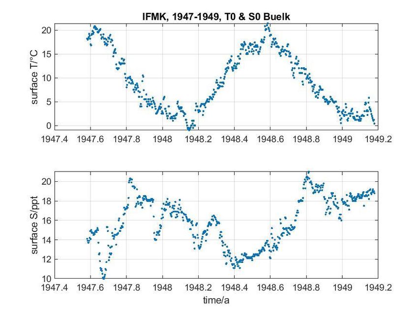
GEOMAR Helmholtz Centre for Ocean Research Kiel: The 1946 - 1956 hydrographic data archive……   -7-

                local time UTC+1 (there was no switch to summer time at that time period).
                Therefore, it is assumed that the
                    o time zone for logged times for all Baltic Sea cruises is UTC+1
                    o time Zone for logged times for the two fishery protection cruises to
                         the Faroes and Iceland is UTC
                    o time values missing in logs were to be filled with 12:00 h (noon)
                         reducing the maximum error in time from 24 h to 12 h.
            •   Latitude & longitude: position was corrected or digitized as given in the
                logs, i.e. almost always to 1/10 minute (185 m in latitude).
            •   Time & position check: After correction and completion of a data set, time
                and location were checked for plausibility using a “platform speed” criterion
                where the platform speed should not exceed 10 knots (the ship’s regular
                maximum speed) by more than 20% between stations, otherwise the
                digitized data were carefully checked against the logs, and eventually
                corrected.
            •   Sampling depth & conversion to sampling pressure: In data sets
                submitted to ICES, DOD/BSH and SeaDataCloud, the sampling depth as
                logged is kept as vertical coordinate. For GEOMAR’s PO-DB, sampling
                depths are converted to pressure P using Saunders (1991) relation
                P=press80(depth, latitude).
            •   Plots: to have a quick view of data density and variability, for each set plots
                were created, except for the North Sea cruise.

            The following data sets resulted; overview plots of the below sets 4.4 to 4.10
            are shown in the App. 3.1 through App. 3.7 in the order of appearance below.

4.2         1950 to 1956 period, Baltic Sea data download from ICES, July 2018
            These data are not complete when compared with the log sheets. The
            downloaded data are
               • improved by including time according to the logs;
               • locations were improved up to 1/10 of latitudinal and longitudinal
                   minutes according to the logs
               • submitted to data centres ICES, DOD/BSH, SeaDataCloud including
                   a preliminary short report

4.3         1946 to 1956 period, Baltic Sea, data missing at ICES
               None of the data from 1946 to 1949 was available on-line or is available in
               another form digitally at ICES (Else J. Green, ICES, October 2018, pers.
               comm.) or at DOD/BSH. Also, some data in the downloaded set of the 1950
               to 1956 period were missing when compared with the logs
               • Baltic Sea data missing in the set downloaded from the ICES on-line
                   data bank, were digitized according to the data logs, except for the time
                   series data at two light vessels and coastal surface data off Bülk, Kiel
                   Fjord (see below).
               • Submitted to data centres ICES, DOD/BSH, SeaDataCloud including
                   a preliminary short report

4.4         1946 to 1956, Baltic Sea (also App. 3.1)
               • The sets under 4.2 and 4.3 were combined to a single set
               • Sampling depths were converted to pressure.
GEOMAR Helmholtz Centre for Ocean Research Kiel: The 1946 - 1956 hydrographic data archive…… -8-
• Stored at GEOMAR’s PO-DB in the local RODB format.
• Copy to LLUR through a joint project with GEOMAR (Prof. Bange,
GEOMAR, pers. comm.)
• Report to IOW, data copy on request
4.5 1946 to 1956, Time Series Station “Boknis-Eck” (also App. 3.2)
In order to extend the station’s existing data set (1956 to present) to earlier
times, a subset was copied from the whole Baltic Sea set under section 4.4:
• The criterion was that the “distance of a station to the time series’
nominal position” must be less than 1 nm (1852 m) to be accepted as a
contribution to the time series at “Boknis-Eck”.
• Stored at GEOMAR’s PO-DB in the local RODB format.
• Copy to LLUR through a joint project with GEOMAR (Prof. Bange,
GEOMAR, pers. comm.)
4.6 1947 to 1949, German light vessel LV “Fehmarn Belt” (also App. 3.3)
This data set is missing in the ICES download, and in the DOD / BSH on-line
data base as well. It consists of hydro casts with temperature and salinity
measurements, repeated on a non-regular time basis. It looks like that IFMK
has substituted the then DHI (now BSH) regular measurements for some
periods.
• This data set was digitized according to the data logs.
• Submitted to data centres: ICES, DOD/BSH, SeaDataCloud
• Stored at GEOMAR’s PO-DB in the local RODB format.
• Copy to LLUR through a joint project with GEOMAR (Prof. Bange,
GEOMAR, pers. comm.)
• Report to IOW, data copy on request
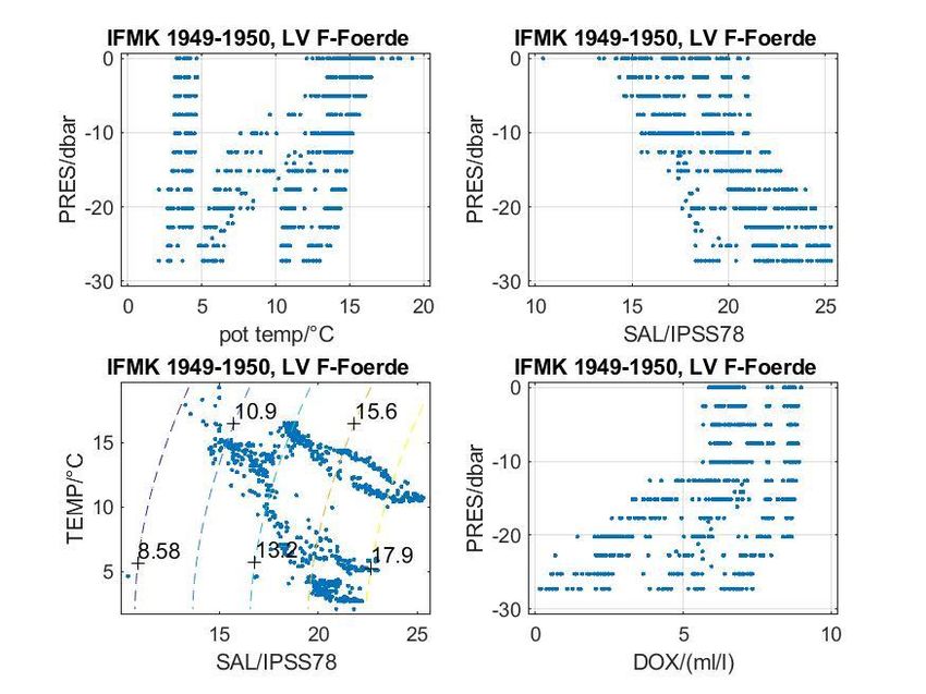
4.7 1949 to 1950, German light vessel LV “Flensburger Förde” (also App. 3.4)
This data set is missing in the ICES download, and in the DOD / BSH on-line
data as well. It consists of hydro casts of temperature and salinity, and often
dissolved oxygen and phosphorus derived from phosphate measurements. The
casts are repeated on a non-regular time basis. It looks like that the IFMK has
substituted the DHI/BSH regular measurements for some periods.
• This data set was digitized according to the data logs.
• Submitted to data centres: ICES, DOD/BSH, SeaDataCloud
• Stored at GEOMAR’s PO-DB in the local RODB format.
• Copy to LLUR through a joint project with GEOMAR (Prof. Bange,
GEOMAR, pers. comm.)
• Report to IOW, data copy on request
4.8 1947 to 1949, coastal surface data off Bülk, Kiel Fjord (also App. 3.5)
This set of daily surface temperature and salinity from August 1947 to March
1949 is missing in the ICES download.
• This data set was digitized according to the data logs.
• Stored at GEOMAR’s PO-DB in the local RODB format.
• Copy to LLUR through a joint project with GEOMAR (Prof. Bange, GEOMAR,
pers. comm.)GEOMAR Helmholtz Centre for Ocean Research Kiel: The 1946 - 1956 hydrographic data archive…… -9-
4.9 1947 and 1953, N.-Atlantic surface and near surface data (also App. 3.6)
These two sets are missing at ICES and DOD.
• These data sets were digitized according to the data logs.
• Submitted to data centres: ICES, DOD/BSH, SeaDataCloud
• Copies to the MRI, Reykjavik, Iceland, and to the FMRI, Thorshavn,
Faroe Islands
• Stored at GEOMAR’s PO-DB in the local RODB format.
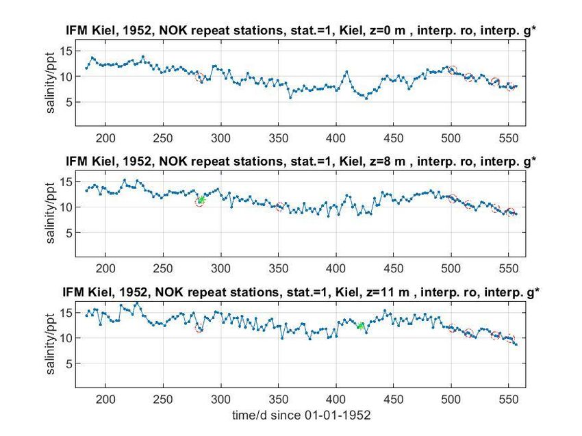
4.10 1952 -1953, Kiel Canal (NOK), salinity time series (also App. 3.7)
This set consists of 164 repetitions at 11 stations along the canal, samples from
the surface, 8 m depth (eastern part only), and above the bottom (11 m).
This set is missing at DOD.
• This data set was digitized according to the data logs.
• Submitted to the DOD
• Stored at GEOMAR’s PO-DB in the local RODB format.
• Copy to LLUR through a joint project with GEOMAR (Prof. Bange,
GEOMAR, pers. comm.)
4.11 North Sea, 1954, eastern German Bight
Data set from off the coast of Schleswig-Holstein stems from a more biologically
oriented cruise. It was flagged “available” at the DOD in 2018, and therefore no
action seemed necessary from a PO-DB perspective.
• Any contact to and copy from the DOD is left to GEOMAR’s cooperation
with LLUR (Prof. Bange, GEOMAR, pers. comm.)
5. Further Background Information
For those interested in earlier work of the then IFMK and its history some hints:
Baltic Sea: Literature on the western Baltic until the mid of the 70s has been compiled
by Schweimer (1978).
IFMK history, in particular that of its physical oceanography departments, is described
by Siedler et al. (2018).
FK “Südfall” became a research cutter at the IFMK already late 1946 after the war.
How that had happened under the British post-war military administration is described
by Ulrich and Kortum (2006, in German) using notes of the ship’s first master, Hans
Ohl, and other sources.
6. Acknowledgments
Without the help of students, such work certainly will be more difficult to conduct. In
particular, I would like to mention the students’ patience while sighting the printed papers
in the dusty conditions under the roof during the extremely warm summer heat in June
2018. Also, digitizing data certainly is an annoying job. The students’ help in sighting and
digitizing was supported through the EU project SeaDataCloud within the EU / Horizon
2020 programme, grant agreement 730960. The coastlines in the Baltic Sea maps
gratefully are provided by the “Leibniz-Institut für Ostseeforschung, Warnemünde” (IOW).GEOMAR Helmholtz Centre for Ocean research Kiel: The 1946 - 1956 hydrographic data archive…… - 10 -
7. References
Saunders, P.M (1981), Practical Conversion of Pressure to Depth, J. Phys. Oc. April 1981.
Schweimer, M. (1978) Physikalisch-ozeanographische Parameter in der westlichen Ostsee: eine
Literaturstudie. . Berichte aus dem Institut für Meereskunde an der Christian-Albrechts-Universität
Kiel, Nr. 61. Institut für Meereskunde, Kiel, Germany, 139 pp. DOI 10.3289/ifm_ber_61.
Siedler, G., Thiede, J. und Zenk, W. (2018) Marine Sciences in Germany: The Restart in Kiel
After World War II. Oceanography, 31 (4). pp. 180-181. DOI 10.5670/oceanog.2018.422.
8. Ships
FK „Südfall“: Ulrich, Johannes und Kortum, Gerhard (2006) Der Forschungskutter "Hermann
Wattenberg" (ex "Südfall"): Basis der Forschung und Lehre des Instituts für Meereskunde in Kiel
1946-1976. Historisch-Meereskundliches Jahrbuch, 12 pp. 65-80.
CV “Alice Freymann”: http://www.shipspotting.com/gallery/photo.php?lid=3043141
FSB “Meerkatze”: https://de.wikipedia.org/wiki/Meerkatze_(Schiff,_1944)
9. Acronyms
BSH Bundesamt für Seeschifffahrt und Hydrographie, Hamburg & Rostock,
Germany
DHI Deutsches Hydrographisches Institut (now integrated in BSH)
DOD Deutsches Ozeanographisches Datenzentrum, BSH, Hamburg,
Germany
FIMR Faroe Institute for Marine Research, Thorshavn, Faroe Islands
GEOMAR Helmholtz-Centre for Ocean Research Kiel, Kiel, Germany
ICES International Council for the Exploration of the Sea, Copenhagen
IFMK Institut für Meereskunde Kiel (now integrated in GEOMAR), Kiel,
Germany
IMR Institute for Marine Research, Reykjavik, Iceland
IOW Leibniz-Institut für Ostseeforschung Warnemünde, Rostock-
Warnemünde, Germany
LLUR Landesamt für Landwirtschaft, Umwelt und ländliche Räume des
Landes Schleswig-Holstein, Flintbek, Germany
PO Physical Oceanography Research Unit(s) at IFMK and at GEOMAR
PO-DB Physical Oceanography data base, GEOMAR, Kiel, GermanyGEOMAR Helmholtz Centre for Ocean Research Kiel: The 1946 - 1956 hydrographic data archive…… - 11 -
Appendix 1
Cover of the file containing 25 hydrographic data sets of IFMK from the years 1946 to 1956.
The headlines in the English translation reads:
Archive of the Institut für Meereskunde
Hydrographic observations from the years 1946, 1947……1956
(The archive contains the values sent to Copenhagen)GEOMAR Helmholtz Centre for Ocean Research Kiel: The 1946 - 1956 hydrographic data archive…… - 12 - Appendix 2 Methods applied to measure temperature, salinity, dissolved oxygen and phosphorus from phosphate during cruises with FK “Südfall” in 1946 to 1956 by IFMK (copy of the cover of one of the data sets, in German; see text for a translation to the English).
GEOMAR Helmholtz Centre for Ocean Research Kiel: The 1946 - 1956 hydrographic data archive……   - 13 -

Appendix 3.1: 1946 to 1956 Baltic Sea hydrographic data overview
GEOMAR Helmholtz Centre for Ocean Research Kiel: The 1946 - 1956 hydrographic data archive……   - 14 -

Appendix 3.2: 1946 to 1956 Time Series Station “Boknis-Eck” overview
GEOMAR Helmholtz Centre for Ocean Research Kiel: The 1946 - 1956 hydrographic data archive……   - 15 -

Appendix 3.3: 1947 to 1949, German light vessel LV “Fehmarn Belt”
GEOMAR Helmholtz Centre for Ocean Research Kiel: The 1946 - 1956 hydrographic data archive……   - 16 -

Appendix 3.4: 1949 to 1950, German light vessel LV “Flensburger Förde”
GEOMAR Helmholtz Centre for Ocean Research Kiel: The 1946 - 1956 hydrographic data archive……   - 17 -

Appendix 3.5: 1947 to 1949, coastal surface data off Bülk, Kiel Fjord
GEOMAR Helmholtz Centre for Ocean Research Kiel: The 1946 - 1956 hydrographic data archive……   - 18 -

Appendix 3.6.1: 1947, surface data north of Iceland, “CV Alice Freymann”
GEOMAR Helmholtz Centre for Ocean Research Kiel: The 1946 - 1956 hydrographic data archive……   - 19 -

Appendix 3.6.2: 1953, surface data North Sea to Faroe and Iceland, “FSB Meerkatze”
GEOMAR Helmholtz Centre for Ocean Research Kiel: The 1946 - 1956 hydrographic data archive……   - 20 -

Appendix 3.7: 1952 -1953, Kiel Canal Kiel Canal, salinity time series, 164 repetitions
Station 1

Station 2
GEOMAR Helmholtz Centre for Ocean Research Kiel: The 1946 - 1956 hydrographic data archive……   - 21 -

Appendix 3.7 (continued)
Station 3

Station 4
GEOMAR Helmholtz Centre for Ocean Research Kiel: The 1946 - 1956 hydrographic data archive……   - 22 -

Appendix 3.7: (continued)
Station 5

Station 6
GEOMAR Helmholtz Centre for Ocean Research Kiel: The 1946 - 1956 hydrographic data archive……   - 23 -

Appendix 3.7: (continued)
Station 7

Station 8
GEOMAR Helmholtz Centre for Ocean Research Kiel: The 1946 - 1956 hydrographic data archive……   - 24 -

Appendix 3.7: (continued)
Station 9

Station 10
GEOMAR Helmholtz Centre for Ocean Research Kiel: The 1946 - 1956 hydrographic data archive……   - 25 -

Appendix 3.7: (continued)
Station 11
GEOMAR Reports
No. Title
1 FS POSEIDON Fahrtbericht / Cruise Report POS421, 08. – 18.11.2011, Kiel - Las Palmas,
Ed.: T.J. Müller, 26 pp, DOI: 10.3289/GEOMAR_REP_NS_1_2012
2 Nitrous Oxide Time Series Measurements off Peru – A Collaboration between SFB 754 and IMARPE
–, Annual Report 2011, Eds.: Baustian, T., M. Graco, H.W. Bange, G. Flores, J. Ledesma,
M. Sarmiento, V. Leon, C. Robles, O. Moron, 20 pp, DOI: 10.3289/GEOMAR_REP_NS_2_2012
3 FS POSEIDON Fahrtbericht / Cruise Report POS427 – Fluid emissions from mud volcanoes, cold
seeps and fluid circulation at the Don-_Kuban deep sea fan (Kerch peninsula, Crimea, Black Sea) –
23.02. – 19.03.2012, Burgas, Bulgaria - Heraklion, Greece, Ed.: J. Bialas, 32 pp,
DOI: 10.3289/GEOMAR_REP_NS_3_2012
4 RV CELTIC EXPLORER EUROFLEETS Cruise Report, CE12010 – ECO2@NorthSea, 20.07. –
06.08.2012, Bremerhaven – Hamburg, Eds.: P. Linke et al., 65 pp,
DOI: 10.3289/GEOMAR_REP_NS_4_2012
5 RV PELAGIA Fahrtbericht / Cruise Report 64PE350/64PE351 – JEDDAH-TRANSECT -,
08.03. – 05.04.2012, Jeddah – Jeddah, 06.04 - 22.04.2012, Jeddah – Duba, Eds.: M. Schmidt,
R. Al-Farawati, A. Al-Aidaroos, B. Kürten and the shipboard scientific party, 154 pp,
DOI: 10.3289/GEOMAR_REP_NS_5_2013
6 RV SONNE Fahrtbericht / Cruise Report SO225 - MANIHIKI II Leg 2 The Manihiki Plateau - O rigin,
Structure and Effects of Oceanic Plateaus and Pleistocene Dynamic of the West Pacific Warm Water
Pool, 19.11.2012 - 06.01.2013 Suva / Fiji – Auckland / New Zealand, Eds.: R. Werner,
D. Nürnberg, and F. Hauff and the shipboard scientific party, 176 pp,
DOI: 10.3289/GEOMAR_REP_NS_6_2013
7 RV SONNE Fahrtbericht / Cruise Report SO226 – CHRIMP CHatham RIse Methane Pockmarks,
07.01. - 06.02.2013 / Auckland – Lyttleton & 07.02. – 01.03.2013 / Lyttleton – Wellington,
Eds.: Jörg Bialas / Ingo Klaucke / Jasmin Mögeltönder, 126 pp,
DOI: 10.3289/GEOMAR_REP_NS_7_2013
8 The SUGAR Toolbox - A library of numerical algorithms and data for modelling of gas
hydrate systems and marine environments, Eds.: Elke Kossel, Nikolaus Bigalke, Elena Piñero,
Matthias Haeckel, 168 pp, DOI: 10.3289/GEOMAR_REP_NS_8_2013
9 RV ALKOR Fahrtbericht / Cruise Report AL412, 22.03.-08.04.2013, Kiel – Kiel. Eds: Peter Linke
and the shipboard scientific party, 38 pp, DOI: 10.3289/GEOMAR_REP_NS_9_2013
10 Literaturrecherche, Aus- und Bewertung der Datenbasis zur Meerforelle (Salmo trutta trutta L.)
Grundlage für ein Projekt zur Optimierung des Meerforellenmanagements in Schleswig-Holstein.
Eds.: Christoph Petereit, Thorsten Reusch, Jan Dierking, Albrecht Hahn, 158 pp,
DOI: 10.3289/GEOMAR_REP_NS_10_2013
11 RV SONNE Fahrtbericht / Cruise Report SO227 TAIFLUX, 02.04. – 02.05.2013, Kaohsiung –
aohsiung (Taiwan), Christian Berndt, 105 pp, DOI: 10.3289/GEOMAR_REP_NS_11_2013
K
12 RV SONNE Fahrtbericht / Cruise Report SO218 SHIVA (Stratospheric Ozone: Halogens in a Varying
Atmosphere), 15.-29.11.2011, Singapore - Manila, Philippines, Part 1: SO218- SHIVA Summary
Report (in German), Part 2: SO218- SHIVA English reports of participating groups,
Eds.: Birgit Quack & Kirstin Krüger, 119 pp, DOI: 10.3289/GEOMAR_REP_NS_12_2013
13 KIEL276 Time Series Data from Moored Current Meters. Madeira Abyssal Plain, 33°N, 22°W,
5285 m water depth, March 1980 – April 2011. Background Information and Data Compilation.
Eds.: Thomas J. Müller and Joanna J. Waniek, 239 pp, DOI: 10.3289/GEOMAR_REP_NS_13_2013GEOMAR Reports
No. Title
14 RV POSEIDON Fahrtbericht / Cruise Report POS457: ICELAND HAZARDS Volcanic Risks from
Iceland and Climate Change:The Late Quaternary to Anthropogene Development Reykjavík /
Iceland – Galway / Ireland, 7.-22. August 2013. Eds.: Reinhard Werner, Dirk Nürnberg and the
shipboard scientific party, 88 pp, DOI: 10.3289/GEOMAR_REP_NS_14_2014
15 RV MARIA S. MERIAN Fahrtbericht / Cruise Report MSM-34 / 1 & 2, SUGAR Site, Varna – Varna,
06.12.13 – 16.01.14. Eds: Jörg Bialas, Ingo Klaucke, Matthias Haeckel, 111 pp,
DOI: 10.3289/GEOMAR_REP_NS_15_2014
16 RV POSEIDON Fahrtbericht / Cruise Report POS 442, “AUVinTYS” High-resolution geological inves-
tigations of hydrothermal sites in the Tyrrhenian Sea using the AUV “Abyss”, 31.10. – 09.11.12,
Messina – Messina, Ed.: Sven Petersen, 32 pp, DOI: 10.3289/GEOMAR_REP_NS_16_2014
17 RV SONNE, Fahrtbericht / Cruise Report, SO 234/1, “SPACES”: Science or the Assessment of
omplex Earth System Processes, 22.06. – 06.07.2014, Walvis Bay / Namibia - Durban / South
C
Africa, Eds.: Reinhard Werner and Hans-Joachim Wagner and the shipbord scientific party, 44 pp,
DOI: 10.3289/GEOMAR_REP_NS_17_2014
18 RV POSEIDON Fahrtbericht / Cruise Report POS 453 & 458, “COMM3D”, Crustal Structure and
cean Mixing observed with 3D Seismic Measurements, 20.05. – 12.06.2013 (POS453), Galway,
O
Ireland – Vigo, Portugal, 24.09. – 17.10.2013 (POS458), Vigo, Portugal – Vigo, Portugal,
Eds.: Cord Papenberg and Dirk Klaeschen, 66 pp, DOI: 10.3289/GEOMAR_REP_NS_18_2014
19 RV POSEIDON, Fahrtbericht / Cruise Report, POS469, “PANAREA”, 02. – 22.05.2014,
(Bari, Italy – Malaga, Spain) & Panarea shallow-water diving campaign, 10. – 19.05.2014,
Ed.: Peter Linke, 55 pp, DOI: 10.3289/GEOMAR_REP_NS_19_2014
20 RV SONNE Fahrtbericht / Cruise Report SO234-2, 08.-20.07.2014, Durban, -South Africa -
Port Louis, Mauritius, Eds.: Kirstin Krüger, Birgit Quack and Christa Marandino, 95 pp,
DOI: 10.3289/GEOMAR_REP_NS_20_2014
21 RV SONNE Fahrtbericht / Cruise Report SO235, 23.07.-07.08.2014, Port Louis, Mauritius to Malé,
Maldives, Eds.: Kirstin Krüger, Birgit Quack and Christa Marandino, 76 pp,
DOI: 10.3289/GEOMAR_REP_NS_21_2014
22 RV SONNE Fahrtbericht / Cruise Report SO233 WALVIS II, 14.05-21.06.2014, Cape Town,
South Africa - Walvis Bay, Namibia, Eds.: Kaj Hoernle, Reinhard Werner, and Carsten Lüter, 153 pp,
DOI: 10.3289/GEOMAR_REP_NS_22_2014
23 RV SONNE Fahrtbericht / Cruise Report SO237 Vema-TRANSIT Bathymetry of the Vema-Fracture
Zone and Puerto Rico TRench and Abyssal AtlaNtic BiodiverSITy Study, Las Palmas (Spain) -
Santo Domingo (Dom. Rep.) 14.12.14 - 26.01.15, Ed.: Colin W. Devey, 130 pp,
DOI: 10.3289/GEOMAR_REP_NS_23_2015
24 RV POSEIDON Fahrtbericht / Cruise Report POS430, POS440, POS460 & POS467 Seismic Hazards
to the Southwest of Portugal; POS430 - La-Seyne-sur-Mer - Portimao (7.4. - 14.4.2012),
POS440 - Lisbon - Faro (12.10. - 19.10.2012), POS460 - Funchal - Portimao (5.10. - 14.10.2013),
POS467 - Funchal - Portimao (21.3. - 27.3.2014), Ed.: Ingo Grevemeyer, 43 pp,
DOI: 10.3289/GEOMAR_REP_NS_24_2015
25 RV SONNE Fahrtbericht / Cruise Report SO239, EcoResponse Assessing the Ecology,
Connectivity and Resilience of Polymetallic Nodule Field Systems, Balboa (Panama) – Manzanillo
(Mexico), 11.03. -30.04.2015, Eds.: Pedro Martínez Arbizu and Matthias Haeckel, 204 pp,
DOI: 10.3289/GEOMAR_REP_NS_25_2015GEOMAR Reports
No. Title
26 RV SONNE Fahrtbericht / Cruise Report SO242-1, JPI OCEANS Ecological Aspects
of Deep-Sea Mining, DISCOL Revisited, Guayaquil - Guayaquil (Equador), 29.07.-25.08.2015,
Ed.: Jens Greinert, 290 pp, DOI: 10.3289/GEOMAR_REP_NS_26_2015
27 RV SONNE Fahrtbericht / Cruise Report SO242-2, JPI OCEANS Ecological Aspects
of Deep-Sea Mining DISCOL Revisited, Guayaquil - Guayaquil (Equador), 28.08.-01.10.2015,
Ed.: Antje Boetius, 552 pp, DOI: 10.3289/GEOMAR_REP_NS_27_2015
28 RV POSEIDON Fahrtbericht / Cruise Report POS493, AUV DEDAVE Test Cruise,
Las Palmas - Las Palmas (Spain), 26.01.-01.02.2016, Ed.: Klas Lackschewitz, 17 pp,
DOI: 10.3289/GEOMAR_REP_NS_28_2016
29 Integrated German Indian Ocean Study (IGIOS) - From the seafloor to the atmosphere -
A possible German contribution to the International Indian Ocean Expedition 2 (IIOE-2)
programme – A Science Prospectus, Eds.: Bange, H.W. , E.P. Achterberg, W. Bach, C. Beier,
C. Berndt, A. Biastoch, G. Bohrmann, R. Czeschel, M. Dengler, B. Gaye, K. Haase, H. Herrmann,
J. Lelieveld, M. Mohtadi, T. Rixen, R. Schneider, U. Schwarz-Schampera, J. Segschneider,
M. Visbeck, M. Voß, and J. Williams, 77pp, DOI: 10.3289/GEOMAR_REP_NS_29_2016
30 RV SONNE Fahrtbericht / Cruise Report SO249, BERING – Origin and Evolution of the Bering Sea:
An Integrated Geochronological, Volcanological, Petrological and Geochemical Approach,
Leg 1: Dutch Harbor (U.S.A.) - Petropavlovsk-Kamchatsky (Russia), 05.06.2016-15.07.2016,
Leg 2: Petropavlovsk-Kamchatsky (Russia) - Tomakomai (Japan), 16.07.2016-14.08.2016,
Eds.: Reinhard Werner, et al., DOI: 10.3289/GEOMAR_REP_NS_30_2016
31 RV POSEIDON Fahrtbericht / Cruise Report POS494/2, HIERROSEIS Leg 2: Assessment of the
Ongoing Magmatic-Hydrothermal Discharge of the El Hierro S ubmarine Volcano, Canary Islands
by the Submersible JAGO, Valverde – Las Palmas (Spain), 07.02.-15.02.2016,
Eds.: Hannington, M.D. and Shipboard Scientific Party, DOI: 10.3289/GEOMAR_REP_NS_31_2016
32 RV METEOR Fahrtbericht / Cruise Report M127, Extended Version, Metal fluxes and Resource
Potential at the Slow-spreading TAG Midocean Ridge Segment (26°N, MAR) – Blue Mining@Sea,
Bridgetown (Barbados) – Ponta Delgada (Portugal) 25.05.-28.06.2016,
Eds.: Petersen, S. and Shipboard Scientific Party, DOI: 10.3289/GEOMAR_REP_NS_32_2016
33 RV SONNE Fahrtbericht /Cruise Report SO244/1, GeoSEA: Geodetic Earthquake Observatory
on the Seafloor, Antofagasta (Chile) – Antofagasta (Chile), 31.10.-24.11.2015,
Eds.: Jan Behrmann, Ingo Klaucke, Michal Stipp, Jacob Geersen and Scientific Crew SO244/1,
DOI: 10.3289/GEOMAR_REP_NS_33_2016
34 RV SONNE Fahrtbericht /Cruise Report SO244/2, GeoSEA: Geodetic Earthquake Observatory
on the Seafloor, Antofagasta (Chile) – Antofagasta (Chile), 27.11.-13.12.2015,
Eds.: Heidrun Kopp, Dietrich Lange, Katrin Hannemann, Anne Krabbenhoeft, Florian Petersen,
Anina Timmermann and Scientific Crew SO244/2, DOI: 10.3289/GEOMAR_REP_NS_34_2016
35 RV SONNE Fahrtbericht /Cruise Report SO255, VITIAZ – The Life Cycle of the Vitiaz-Kermadec
Arc / Backarc System: from Arc Initiation to Splitting and Backarc Basin Formation, Auckland
(New Zealand) - Auckland (New Zealand), 02.03.-14.04.2017, Eds.: Kaj Hoernle, Folkmar Hauff,
and Reinhard Werner with contributions from cruise participants,
DOI: 10.3289/GEOMAR_REP_NS_35_2017GEOMAR Reports
No. Title
36 RV POSEIDON Fahrtbericht /Cruise Report POS515, CALVADOS - CALabrian arc mud VolcAnoes:
Deep Origin and internal Structure, Dubrovnik (Croatia) – Catania (Italy), 18.06.-13.07.2017,
Eds.: M. Riedel, J. Bialas, A. Krabbenhoeft, V. Bähre, F. Beeck, O. Candoni, M. Kühn, S. Muff,
J. Rindfleisch, N. Stange, DOI: 10.3289/GEOMAR_REP_NS_36_2017
37 RV MARIA S. MERIAN Fahrtbericht /Cruise Report MSM63, PERMO, Southampton – Southampton
(U.K.), 29.04.-25.05.2017, Eds.: Christian Berndt and Judith Elger with contributions from cruise
participants C. Böttner, R.Gehrmann, J. Karstens, S. Muff, B. Pitcairn, B. Schramm, A. Lichtschlag,
A.-M. Völsch, DOI: 10.3289/GEOMAR_REP_NS_37_2017
38 RV SONNE Fahrtbericht /Cruise Report SO258/1, INGON: The Indian - Antarctic Break-up Engima,
Fremantle (Australia) - Colombo (Sri Lanka), 07.06.-09.07.2017, 29.04.-25.05.2017,
Eds.: Reinhard Werner, Hans-Joachim Wagner, and Folkmar Hauff with contributions from
cruise participants, DOI: 10.3289/GEOMAR_REP_NS_38_2017
39 RV POSEIDON Fahrtbericht /Cruise Report POS509, ElectroPal 2: Geophysical investigations of
sediment hosted massive sulfide deposits on the Palinuro Volcanic Complex in the Tyrrhenian Sea,
Malaga (Spain) – Catania (Italy), 15.02.-03.03.2017, Ed.: Sebastian Hölz,
DOI: 10.3289/GEOMAR_REP_NS_39_2017
40 RV POSEIDON Fahrtbericht /Cruise Report POS518, Baseline Study for the Environmental Moni
toring of Subseafloor CO2 Storage Operations, Leg 1: Bremerhaven – Bremerhaven (Germany),
25.09.-11.10.2017, Leg 2: Bremerhaven – Kiel (Germany), 12.10.-28.10.2017,
Eds.: Peter Linke and Matthias Haeckel, DOI: 10.3289/GEOMAR_REP_NS_40_2018
41 RV MARIA S. MERIAN Fahrtbericht /Cruise Report MSM71, LOBSTER: Ligurian Ocean Bottom
Seismology and Tectonics Research, Las Palmas (Spain) – Heraklion (Greece), 07.02.-27.02.2018,
Eds.: H. Kopp, D. Lange, M. Thorwart, A. Paul, A. Dannowski, F. Petersen, C. Aubert, F. Beek,
A. Beniest, S. Besançon, A. Brotzer, G. Caielli, W. Crawford, M. Deen, C. Lehmann, K. Marquardt,
M. Neckel, L. Papanagnou, B. Schramm, P. Schröder, K.-P. Steffen, F. Wolf, Y. Xia,
DOI: 10.3289/GEOMAR_REP_NS_41_2018
42 RV METEOR Fahrtbericht /Cruise Report M143, SLOGARO: Slope failures and active gas expulsion
along the Romanian margin – investigating relations to gas hydrate distribution, Varna (Romania) –
Heraklion (Greece), 12.12.-22.12.2017, Eds.: M. Riedel, F. Gausepohl, I. Gazis, L. Hähnel,
M. Kampmeier, P. Urban, J. Bialas, DOI: 10.3289/GEOMAR_REP_NS_42_2018
43 RV POSEIDON Fahrtbericht /Cruise Report POS510, ANYDROS: Rifting and Hydrothermal Activity
in the Cyclades Back-arc Basin, Catania (Italy) – Heraklion (Greece), 06.03.-29.03.2017,
Ed.: M.D. Hannington, DOI: 10.3289/GEOMAR_REP_NS_43_2018
44 RV POSEIDON Fahrtbericht /Cruise Report POS524, GrimseyEM: Geophysical and geological
investigations in the vicinity of the Grimsey Hydrothermal Field offshore Northern Iceland for the
assessment of the geothermal potential and the exploration for potential mineralizations within the
seafloor, Reykjavik (Iceland) – Bergen (Norway), 7.6 - 26.6.2018, Eds.: Sebastian Hölz and Sofia
Martins, DOI: 10.3289/GEOMAR_REP_NS_44_2018
45 RV POSEIDON Fahrtbericht /Cruise Report POS527, Baseline Study for the Environmental
onitoring of Subseafloor CO2 Storage Operations, Kiel – Kiel (Germany), 15.8. - 3.9.2018,
M
Eds.: Eric Achterberg and Mario Esposito, DOI: 10.3289/GEOMAR_REP_NS_45_2018GEOMAR Reports
No. Title
46 RV SONNE Fahrtbericht /Cruise Report SO264, SONNE-EMPEROR: The Plio/Pleistocene to Holocene
development of the pelagic North Pacific from s
urface to depth – assessing its role for the global
carbon budget and Earth´s climate, Suva (Fiji) – Yokohama (Japan), 30.6. – 24.8.2018
Ed.: Dirk Nürnberg, DOI: 10.3289/GEOMAR_REP_NS_46_2018
47 RV SONNE Fahrtbericht /Cruise Report SO265, SHATSKY EVOLUTION: Evolution of the Shatsky
Rise Hotspot System, Yokohama (Japan) – Kaohsiung (Taiwan), 26.08. – 11.10.2018, Eds.:
Jörg Geldmacher, Reinhard Werner, and Folkmar Hauff with contributions from cruise participants,
DOI: 10.3289/GEOMAR_REP_NS_47_2018
48 RV MARIA S. MERIAN Fahrtbericht /Cruise Report MSM78, PERMO 2, Edinburgh – Edinburgh (U.K.),
16.10. – 25.10.2018, Eds.: Jens Karstens, Christoph Böttner, Mike Edwards, Ismael Falcon-Suarez,
Anita Flohr, Rachael James, Anna Lichtschlag, Doris Maicher, Iain Pheasant, Ben Roche, Bettina
Schramm, Michael Wilson, DOI: 10.3289/GEOMAR_REP_NS_48_2019
49 RV SONNE Fahrtbericht /Cruise Report SO267, ARCHIMEDES I: Arc Rifting, Metallogeny and Micro-
plate Evolution – an Integrated Geodynamic, Magmatic and Hydrothermal Study of the Fonualei Rift
System, NE Lau Basin, Suva (Fiji) – Suva (Fiji), 11.12.2018 – 26.01.2019, Eds.: Mark Hannington,
Heidrun Kopp, Michael Schnabel, DOI: 10.3289/GEOMAR_REP_NS_49_2019
50 RV Pelagia Fahrtbericht /Cruise Report 64PE-445, SALTAX: Geomorphology and geophysics of sub-
marine salt flows in the Red Sea Rift, Limassol (Cyprus) – Safaga (Egypt), 27.08. – 21.09.2018,
Eds.: Nico Augustin, Neil C. Mitchell, Froukje M. van der Zwan & Scientific Shipboard Party,
DOI: 10.3289/GEOMAR_REP_NS_50_2019
51 RV POSEIDON Fahrtbericht /Cruise Report POS526, SeASOM: Semi-Autonomous Subsurface
Optical Monitoring for methane seepage and cold-water coral studies in the North Sea,
Bergen (Norway) – Doggerbank (Netherlands) – Hirtshals (Denmark) – Tisler (Norway) –
Kiel (Germany), 23.07. – 11.08.2018, Eds.: Jens Greinert, Tim Schoening,
DOI: 10.3289/GEOMAR_REP_NS_51_2019
52 RV POSEIDON Fahrtbericht /Cruise Report POS534, STEMM-CCS: Strategies for Environmental
onitoring of Marine Carbon Capture and Storage, Leg 1: Kiel (Germany) – Aberdeen
M
(United Kingdom), 01.05. – 22.05.2019, Leg 2: Aberdeen (United Kingdom) – Bremerhaven
(Germany), 23.05. – 29.05.2019, Ed.: Mark Schmidt, DOI: 10.3289/GEOMAR_REP_NS_52_2019
53 RV POSEIDON Fahrtbericht /Cruise Report POS535, Loki2GrimseyEM: Geophysical and g eological
investigations of massive sulfides at and in the vicinity of Loki’s Castle (Norway) and similar
experiments around the Grimsey Hydrothermal Field (Iceland) for the assessment of the
geothermal potential and the exploration for potential mineralizations within the seafloor,
Akureyri (Iceland)– Bremerhaven (Germany), 09.06 – 03.07.2019, Eds.: Sebastian Hölz,
Amir Haroon and S ofiaMartins, DOI: 10.3289/GEOMAR_REP_NS_53_2019
54 Practical Guide for Environmental Monitoring of Conventional Munitions in the Seas, Results from
the BMBF funded project UDEMM “Umweltmonitoring für die Delaboration von Munition im Meer”
Ed.: Jens Greinert, DOI: 10.3289/GEOMAR_REP_NS_54_2019
55 RV ALKOR Fahrtbericht /Cruise Report AL533, Mutual Field Trials of the Manned Submersible JAGO
and the Hover-AUVs ANTON and LUISE off the Aeolian Islands, Mediterranean Sea, Catania (Italy)–
La Seyne-sur-mer (France), 05.02. – 18.02.2020, Authors: Karen Hissmann, Marcel Rothenbeck,
Emanuell Wenzlaff, Tim Weiß, Patrick Leibold, DOI: 10.3289/GEOMAR_REP_NS_55_2020GEOMAR Reports
No. Title
56 RV POSEIDON Fahrtbericht /Cruise Report POS536/Leg 1, DIPLANOAGAP: Distribution of Plastics
in the North Atlantic Garbage Patch, Ponta Delgada (Portugal) – Malaga (Spain),
17.08. – 12.09.2019, Author: Mark Lenz, DOI: 10.3289/GEOMAR_REP_NS_56_2020
57 RV SONNE Fahrtbericht /Cruise Report SO277, OMAX: Offshore Malta Aquifer Exploration,
Emden (Germany) – Emden (Germany), 14.08. – 03.10.2020, Autor / Author: Christian Berndt
with contributions by Morelia Urlaub, Marion Jegen, Zarah Faghih, Konstantin Reeck, Gesa Franz,
Kim Carolin Barnscheidtt, Martin Wollatz-Vogt, Jonas Liebsch, Bettina Schramm, Judith Elger,
Michel Kühn, Thomas Müller, Mark Schmidt, Timo Spiegel, Henrike Timm, Anina-Kaja Hinz,
Thore Sager, Helene Hilbert, Lea Rohde, Torge Korbjuhn, Silvia Reissmann, Nicolaj Diller,
DOI 10.3289/GEOMAR_REP_NS_57_2021
58 The 1946 - 1956 Hydrographic Data Archive at the Institut für Meereskunde, Kiel, digitized,
A data-guide by Thomas J. Müller, GEOMAR Helmholtz Centre for Ocean Research,
DOI 10.3289/GEOMAR_REP_NS_58_2021
For GEOMAR Reports, please visit:
https://oceanrep.geomar.de/view/series/GEOMAR_Report.html
Reports of the former IFM-GEOMAR series can be found under:
https://oceanrep.geomar.de/view/series/IFM-GEOMAR_Report.htmlDas GEOMAR Helmholtz-Zentrum für Ozeanforschung Kiel The GEOMAR Helmholtz Centre for Ocean Research Kiel
ist Mitglied der Helmholtz-Gemeinschaft is a member of the Helmholtz Association of
Deutscher Forschungszentren e.V. German Research Centres
Helmholtz-Zentrum für Ozeanforschung Kiel / Helmholtz Centre for Ocean Research Kiel
GEOMAR
Dienstgebäude Westufer / West Shore Building
Düsternbrooker Weg 20
D-24105 Kiel
Germany
Helmholtz-Zentrum für Ozeanforschung Kiel / Helmholtz Centre for Ocean Research Kiel
GEOMAR
Dienstgebäude Ostufer / East Shore Building
Wischhofstr. 1-3
D-24148 Kiel
Germany
Tel.: +49 431 600-0
Fax: +49 431 600-2805
www.geomar.deYou can also read