The Australian Height Datum Turns 50: Past, Present & Future - Spatial Services
←
→
Page content transcription
If your browser does not render page correctly, please read the page content below
Proceedings of the APAS Webinar Series 2021 (AWS2021)
                                       24 March – 30 June 2021

                The Australian Height Datum Turns 50:
                       Past, Present & Future

                                       Volker Janssen
                                     DCS Spatial Services
                             NSW Department of Customer Service
                          Volker.Janssen@customerservice.nsw.gov.au
                                       Simon McElroy
                                    DCS Spatial Services
                             NSW Department of Customer Service
                          Simon.McElroy@customerservice.nsw.gov.au

ABSTRACT

The Australian Height Datum (AHD) celebrates its Golden Jubilee (50th birthday) this year.
This stalwart of Australian surveying remains our nation’s first and only legal vertical datum.
Recently, the ever-increasing use of Global Navigation Satellite System (GNSS) observations
and airborne gravity measurements has led to the development of the Australian Vertical
Working Surface (AVWS) as an alternative for advanced users and early adopters requiring
higher-quality physical heights. This paper celebrates the achievements of AHD and its
longevity, outlines its shortcomings and describes the datum maintenance and modernisation
efforts undertaken by DCS Spatial Services to not only preserve but improve access to AHD,
while also providing a solid foundation for AVWS across the State. It also looks ahead to a new
era of vertical datum determination based on GNSS observations and gravity measurements.
Acknowledging that there can be only one legal vertical datum, it remains to be seen what the
future holds for legal heights in NSW and Australia.

KEYWORDS: Australian Height Datum (AHD), Australian Vertical Working Surface (AVWS),
AUSGeoid2020, AUSPOS, datum modernisation.

1 INTRODUCTION

The Australian Height Datum (AHD) celebrates its 50th birthday this year and remains
Australia’s first and only legal vertical datum (Roelse et al., 1975). A vertical datum defines a
reference for elevation comparisons and is essential for a wide range of applications relying on
the flow of fluids, such as floodplain management, waterway navigation management, roadway
and drainage design, agricultural management, and surveying in general. Vertical datums will
also be essential and of interest to a wider audience as we move to 3-dimensional digital twins
of the real world in which we work and play. Today’s modern surveyor regularly works with
two types of heights: ellipsoidal heights referred to the Geocentric Datum of Australia
(GDA2020 – see ICSM, 2020a) and physical heights referred to AHD. In NSW, both are
available through the Survey Control Information Management System (SCIMS), the State’s
database containing about 250,000 survey marks on public record across NSW, including
coordinates, heights, accuracy classifications and other metadata, provided in GDA94,
GDA2020 and AHD (Janssen et al., 2019).

                                                3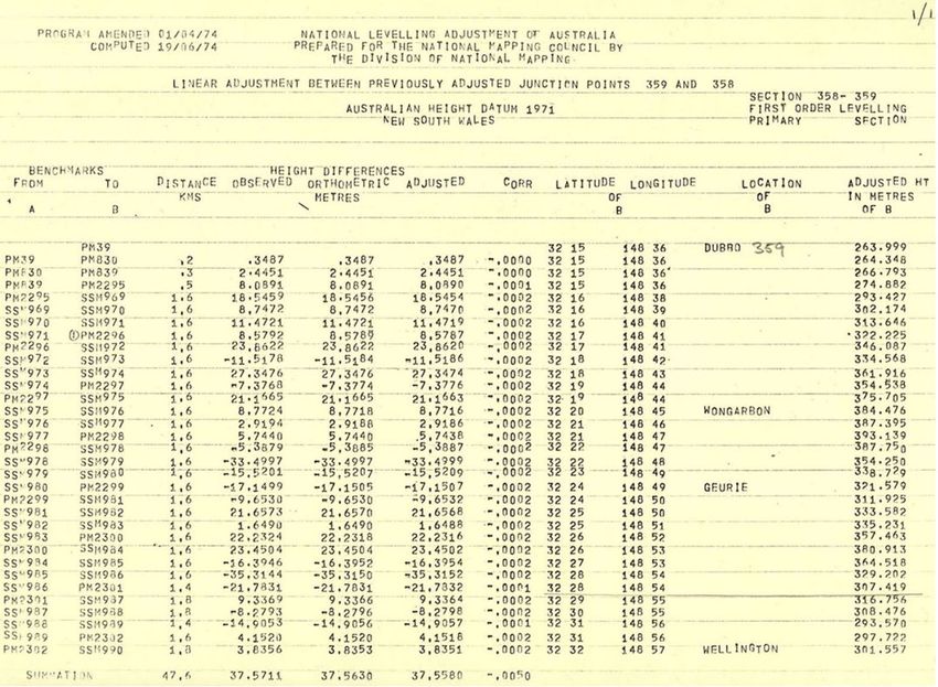
Proceedings of the APAS Webinar Series 2021 (AWS2021)
                                         24 March – 30 June 2021

This paper focuses on physical heights in NSW and celebrates the achievements of AHD,
outlines its shortcomings and looks ahead to a new era of vertical datum determination, based
on Global Navigation Satellite System (GNSS) observations and gravity measurements,
culminating in the Australian Vertical Working Surface (AVWS – see ICSM, 2020b). Recent
developments in airborne gravity measurements are outlined and discussed in the Australian
context to provide an indication of what may be on the horizon in the near future.

2 THE PAST

Celebrating its Golden Jubilee this year, AHD is Australia’s first and only legal vertical datum.
In NSW, it replaced the Standard Datum, which had been in use for some 80 years and was
defined by the value of Mean Sea Level (MSL) at Fort Denison, accessible via a survey plug
that was installed in 1882 (and still exists as PM50000) on the external northern wall of the
former Department of Lands building in Bridge Street, Sydney (Figures 1 & 2). An interesting
account of what transpired in the lead-up to the establishment of the Standard Datum and the
introduction of AHD can be found in Blume (1975).

AHD (sometimes referred to as AHD71) was partly funded through a special 1961 Federal
Government program to support the search for oil in Australia, via levelling within and
connections between the various sedimentary basins (Granger, 1972; Roelse et al., 1975). In
May 1971, it was adopted by the National Mapping Council as the datum to which all vertical
control for mapping was to be referred. AHD was realised by setting MSL to zero at 30 tide
gauges distributed around the coast of mainland Australia and adjusting 97,320 km of ‘primary’
2-way spirit levelling across the country. The observations for MSL spanned 3 years (between
1 January 1966 and 31 December 1968) for all but one tide gauge, with earlier data over 4 years
(between 1 January 1957 and 31 December 1960) being used at Karumba in the Gulf of
Carpentaria. A subsequent adjustment also included about 80,000 km of ‘supplementary’ 1-
way and 2-way spirit levelling, in addition to and dependent upon the ‘primary’ levelling
(Roelse et al., 1975). For the first time, this provided a nationwide network of physical heights
known as the Australian National Levelling Network (ANLN) – a stunning and quickly
implemented achievement that required enormous effort. Prior to AHD, many disconnected
local height datums were used in the states and territories.

Figure 1: Survey plug (now PM50000) on the external northern wall of the former Department of Lands building
                                        in Bridge Street, Sydney.

                                                     4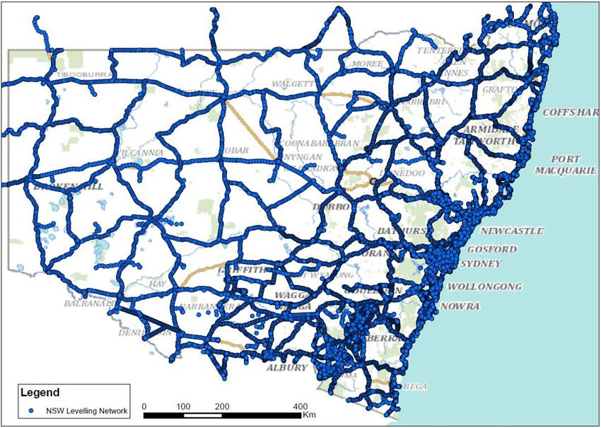
Proceedings of the APAS Webinar Series 2021 (AWS2021)
                                           24 March – 30 June 2021

Figure 2: Specifying corrections for various values used for the Department of Lands plug to refer its level to the
                                       Standard Datum for NSW in 1915.

The question is naturally asked why third-order levelling was used for the primary survey, and
the short answer is that this practice was followed in order to produce the most useful outcome
within the framework of funds and time available (e.g. Granger, 1972; Lambert and Leppert,
1976). From that point of view, third-order levelling certainly provided an adequate basis for
the topographic mapping program, for general engineering purposes, and for the coordination
of levelling surveys undertaken during gravity observations. According to Lambert and Leppert

                                                        5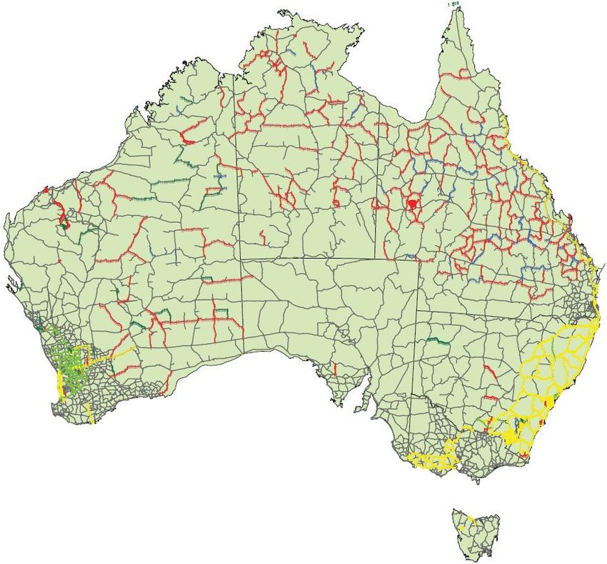
Proceedings of the APAS Webinar Series 2021 (AWS2021)
                                       24 March – 30 June 2021

(1976), anything more was reportedly considered as “striving against the forces of nature in
order to achieve an impossible dream”. The authors pointed out that an important time
consideration was the fact that third-order levelling could be accomplished with readily
available equipment and by available professional staff found in both the government and
private sector. Considering the cost factor, as a rough rule of thumb, they determined that an
increase in a survey operation by a factor n involves an increase in time and funds of n2. On
this basis, they estimated that the 160,000 km of the Australian survey, which cost
approximately $7M if carried out say 25% to first order, 25% to second and 50% to third order,
would have cost about $24M in those days (or $105M and $358M today, respectively).
Furthermore, even if better leveling standards had been adopted, this accuracy would have been
swamped in the warping of the level surface to hold MSL equal to zero at the tide gauges.

2.1 Practical Realisation of AHD in NSW

On the ground in NSW, AHD was realised by networks of approved survey marks. Some states
organised their own ground marking and benefited as a result, others left this to contract
surveyors (Lambert and Leppert, 1976). Typically, AHD marks were placed at intervals of one
mile in regional areas and two miles in remote areas (e.g. Western Division), usually following
major roads. In towns and cities, the network was far denser. The separation was also varied to
enable marks to be placed at easily identifiable locations (e.g. crossroads, property entrances,
hill crests and bridges) in an era predating handheld GNSS positioning or even full mapping of
the State. In many instances, ANLN marks were located close to existing road mile posts for
easier retrieval.

Marking typically consisted of five SSMs (PSM Type 1 – Ground Level) followed by a PM
(PSM Type 6 employing a stainless-steel rod), with this pattern being repeated for the entire
level run. Sometimes, pairs of PMs on opposite sides of the road were placed to provide extra
redundancy. Different level runs met and joined at Junction Points (labelled JP in SCIMS).
Marks specifically placed for AHD are easily identifiable by their low consecutive number
series, while existing marks were included in the level run along the way. Later, marking
became more non-standard with entire runs sometimes consisting of only PMs or only SSMs
and inter-station distances opting between miles or kilometres. Marks also varied with soil
condition (PSM Type 8 – Department of Water Resources Type C) and/or when existing
surveys were to be adopted or recycled (e.g. ACT’s Rural Bench Mark [RBM] and the Snowy
Mountains Hydro-Electric Authority’s Permanent Bench Mark [PBM]).

Later, in the 1970s, NSW installed a series of Fundamental Bench Marks (FBMs) and Geodetic
Bench Marks (GBMs). These were high-stability marks designed to physically hold and
preserve AHD. Based on a European design, they were modified for Australian conditions, akin
to trigonometrical (trig) stations for height. FBMs and GBMs consisted of 2-3 marks installed
in clusters at each location, with the primary mark being located under a standard cover box.
Marks consisted of stainless-steel rods driven to refusal in auger holes that were backfilled with
sand to decouple the mark from any local soil movement (Figure 3).

FBMs and GBMs were placed in locations next to ANLN runs, including parks, schools, police
stations and an interesting collection of golf course club houses. AHD was then transferred to
these marks by separate first-order levelling runs. An extensive network of FBMs and GBMs
was envisaged when construction began in 1973 and marks were placed and surveyed (Naylor,
1976), predominately in eastern NSW with a higher density in north-eastern NSW.
Unfortunately, the program was abruptly terminated due to budget constraints and an inter-

                                                6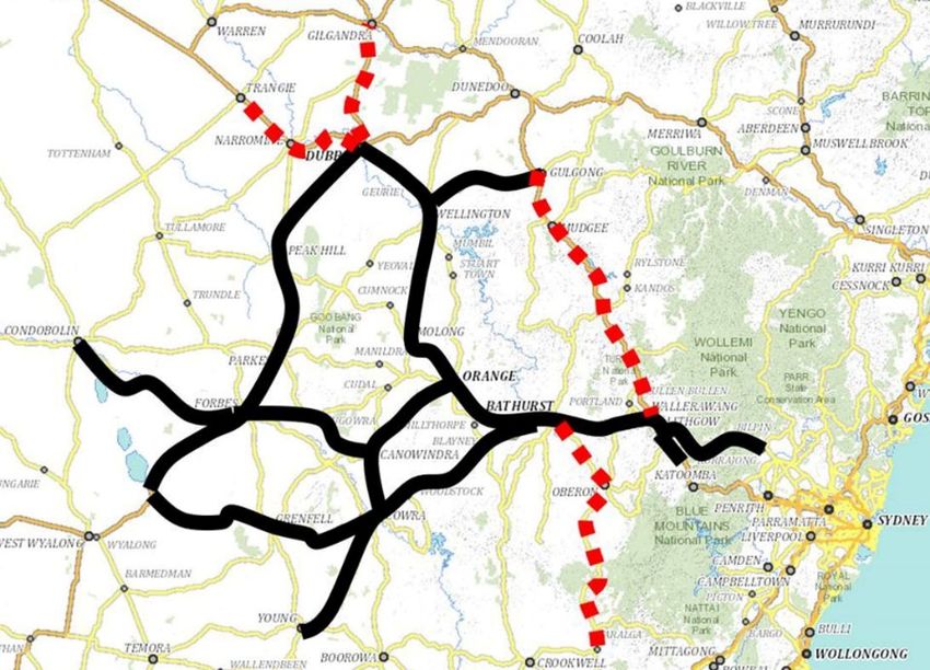
Proceedings of the APAS Webinar Series 2021 (AWS2021)
                                      24 March – 30 June 2021

departmental disagreement as to who would pay for the repairs to a loaned Public Works
Department (PWD) vehicle that mounted the drilling auger (!).

                   Figure 3: Fundamental Bench Mark (FBM) design (Naylor, 1976).

As stated earlier, AHD was designed as a third-order levelling network to produce the most
efficient result within the framework of funds and time available (e.g. Granger, 1972; Lambert
and Leppert, 1976). However, NSW set a far higher standard and supplemented, strengthened
and improved AHD by observing the nation’s most extensive and ambitious network of first-
order levelling (Figure 4), which extended throughout the Eastern and Central Divisions of the

                                                7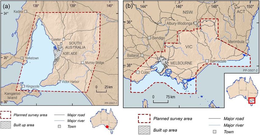
Proceedings of the APAS Webinar Series 2021 (AWS2021)
                                          24 March – 30 June 2021

State. Whilst third-order levelling was performed by private sector contractors (whose
participation was vital to the timely completion of AHD), first-order levelling was conducted
by the Central Mapping Authority (CMA), now DCS Spatial Services, a business unit of the
NSW Department of Customer Service (DCS). This first-order levelling network covered the
length of the NSW seaboard, connecting tide gauges and extending as far west as Albury,
Jerilderie, Wagga Wagga, Cootamundra, Cowra, Orange, Dubbo, Gilgandra, Coonabarabran,
Narrabri, Bingara and Ashford (on the Queensland border). It also included existing first-order
levelling, e.g. from the Snowy Mountains Hydro-Electric Authority (SMA).

Figure 4: ANLN, showing first-order levelling sections (yellow), second-order sections (light green), third-order
 (fine grey), fourth-order (dark green), 1-way third-order (red) and 2-way levelling of undefined quality (blue)
                                              (Filmer et al., 2010).

Over the years, further level runs of various quality and including 1-way levelling were added
to extend the network and/or investigate anomalies. An extensive capillary network of levelling
to mountain-top trig stations was also established, typically 1-way only, connecting to the
nearest ANLN mark (labelled T to T levelling, with T junction labels in SCIMS). To this day,
discussions continue about the existence and nature of any systematic errors that may lay
dormant in this then fit-for-purpose survey methodology. For DCS Spatial Services, the era of
optically (or digitally) observing extensive levelling networks ended well before the start of the
21st century, and in-house geodetic levelling subject matter experts have since retired. Today,
AHD is primarily derived from GNSS baseline networks (Class B), while digital levelling is
only conducted for special projects, ad-hoc surveys or in some urban instances.

                                                       8
Proceedings of the APAS Webinar Series 2021 (AWS2021)
                                        24 March – 30 June 2021

2.2 Adjustment of the ANLN

Prior to the adjustment, observed levelling data was corrected for the effect of non-parallelism
of equipotential surfaces by applying the orthometric correction based on normal gravity (e.g.
Granger, 1972; Roelse et al., 1975; Lambert and Leppert, 1976). Normal gravity is an
approximation of true gravity generated from a mathematical model representing the Earth.
Orthometric corrections can be as large as several centimetres in mountainous regions where
the level surfaces exhibit steeper slopes than in lowlands, e.g. 309 mm correction for the 146
km level run from Adaminaby into the Snowy Mountains vs. 33 mm correction for the 155 km
level run between Dubbo and Forbes. For the technically minded, AHD is thus considered a
normal-orthometric height system because existing gravity observations were insufficient (e.g.
Featherstone and Kuhn 2006; Filmer et al., 2010). Instead, a truncated normal-orthometric
correction was applied to the spirit levelling observations, which only utilised normal gravity
(i.e. referenced to an ellipsoid approximating the Earth, in this case GRS67). For a detailed
treatment of height systems and vertical datums in the Australian context, the reader is referred
to Featherstone and Kuhn (2006) and Filmer et al. (2010). A technical discussion of the
difference between the geoid (the equipotential surface that best approximates MSL and is the
basis for orthometric heights, measured along the curved plumbline based on Earth’s gravity)
and the quasigeoid (the non-equipotential surface that normal heights refer to, measured along
the slightly curved ellipsoid normal based on normal gravity) can be found, e.g., in Vaniček et
al. (2012) and Sjöberg (2013, 2018).

The interconnected network of level sections and junction points was constrained at 30 tide
gauge sites, which were assigned an AHD height of zero. In NSW, this included the tide gauges
at Coffs Harbour, Sydney’s Camp Cove and Port Kembla, while Eden was excluded at the
request of the Victorian and NSW Surveyors-General due to poor data (Roelse et al., 1975).
The selection of Camp Cove (established in 1916) over Fort Denison, the second continuously
recording tide gauge established in Australia in 1886 with records dating back even further and
a long association with levelling datums, was attributed to the difficulty in making the cross-
water connection (about 600 m between the island and Mrs Macquarie’s Point) and the
existence of a tidal gradient between the entrance to Sydney Harbour and Fort Denison (Blume,
1975; Lands, 1976). While it was noted that there were many interruptions to the national tide
gauge network recordings due to theft, vandalism and faulty gauges, acceptable results were
obtained from the 30 gauges eventually chosen (Granger, 1972).

The least squares adjustment propagated MSL heights, or AHD heights, across the levelling
network. This adjustment occurred in two phases due to the computational limits of CSIRO’s
impressive CDC 3600 computer used at the time (Figure 5).

           Figure 5: Control Data Corporation CDC 3600 computer used for the AHD adjustment.

                                                  9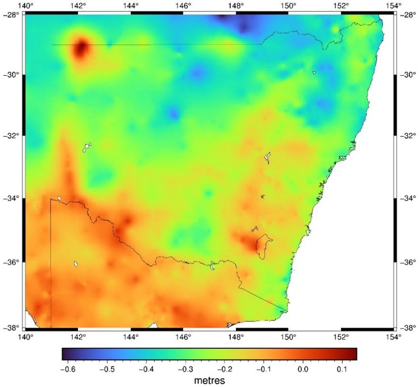
Proceedings of the APAS Webinar Series 2021 (AWS2021)
                                        24 March – 30 June 2021

In phase 1, five regional adjustments were made within boundaries approximating state limits
(i.e. WA, SA and NT, QLD, NSW, VIC). In phase 2, these were combined to produce two
solutions: (1) a minimally constrained solution with one station held fixed (Johnston Geodetic
Station in central Australia) to assess the quality of the levelling, and (2) the final adjustment
constrained to the 30 tide gauges, run on 5 May 1971 (Granger, 1972; Roelse et al., 1975;
Lambert and Leppert, 1976). The minimally constrained solution indicated a standard deviation
of about 0.3 m in the centre of Australia. Despite the best efforts of surveyors, gross, random
and systematic errors crept into the level sections and were distributed across the network within
the adjustment (ICSM, 2020a).

Lambert and Leppert (1976) noted the average loop closure was ± 6 mm/√km but the loop
closures did not conform to a normal distribution. The average correction applied to the regional
adjustments was ± 3 mm/√km. An assessment of the standard weight of the minimally
constrained adjustment was ± 7 mm/√km for all states but NSW, which had an issue. Analysis
indicated a degree of suspicion in respect to either the mathematical model or the processed
data. Detailed analysis indicated that the data for the south-eastern corner of NSW was
statistically inferior despite the existence of mostly first-order levelling. They reported that this
would seem to indicate that, after a number of years, first-order surveys tend to deteriorate to
much the same order of accuracy as third-order levelling.

It should be noted that Lord Howe Island and Norfolk Island are not covered by AHD and
continue to use local historical height datums, the origins of which require more detailed
investigation, documentation and public communication. As an aside, the Tasmanian AHD
(often referred to as AHD-TAS83 or AHD83) was realised separately by setting MSL
observations for only one entire year (1972) to zero at the tide gauges in Hobart and Burnie. It
was propagated using mostly third-order levelling over 72 sections between 57 junction points
and adjusted on 17 October 1983 (ICSM, 2020a).

2.3 Shortcomings of AHD

Over time, significant and well-documented shortcomings in the AHD realisation became
apparent. In short, due to dynamic ocean effects (e.g. winds, currents, atmospheric pressure,
temperature and salinity), tide gauge observations only spanning a period of 3 years and the
omission of observed gravity, MSL was not coincident with the geoid at the tide gauge
locations. The primary bias with respect to the geoid is due the AHD realisation ignoring the
effect of the ocean’s time-mean dynamic topography, resulting in AHD being about 0.5 m
above the geoid in north-east Australia and about 0.5 m below the geoid in south-west Australia
(Featherstone and Filmer, 2012). Together with uncorrected gross, random and systematic
levelling errors, this introduced considerable distortions of up to about 1.5 m into AHD across
Australia (e.g. Morgan, 1992; Featherstone and Filmer, 2012; Watkins et al., 2017). The
interested reader is referred to the readily available literature for many more investigations into
the shortcomings of AHD.

For example, observational blunders included those caused by observing in imperial units,
where a whole foot was easily ‘dropped’ and/or ‘picked up’. Random errors included those
caused by metrification in Australia, having to use metres in calculations although the data was
observed in feet. However, there were also downright fraudulent level runs, including the fable
of the private contractor who supposedly adjusted out a misclose of more than 7 feet while
enjoying a cold beer at a pub in Tibooburra. Lambert and Leppert (1976) also politely noted at

                                                 10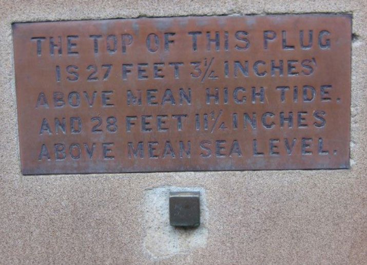
Proceedings of the APAS Webinar Series 2021 (AWS2021)
                                       24 March – 30 June 2021

the time that an unexpected effect appears to have been the independent approach of a few
surveyors who did not fully conform to the prescribed specifications.

Despite all this, AHD has, overall, continued to be a practical height datum that is fit for
purpose, providing a sufficient robustness for many surveying and engineering applications and
even ‘mums and dads’, particularly over smaller areas (less than 10 km). For most surveyors,
AHD has been ubiquitous for the entire duration of their professional careers, being the vertical
datum of choice (when available) because it was the only one.

3 THE PRESENT

Over the last half century, surveyors have continued to extend and propagate AHD, primarily
in urban regions, along transport corridors and within large infrastructure projects. However,
large sections of the State, particularly rural and remote NSW, and even some suburbs of
Sydney, do not have and have never had AHD established. When it does exist in these areas, it
has been derived from GNSS.

A further issue affecting the availability of AHD is mark destruction. Despite the best efforts
in the Preservation of Survey Infrastructure (POSI – see DCS Spatial Services, 2020a), entire
sections of original ANLN spirit-levelled AHD have been destroyed. Ad-hoc audits indicate
mark destruction is far higher in eastern NSW, with some level runs completely lost in city
regions or along highways. In rural and remote areas, marks often still exist but can be difficult
to find due the removal of all physical connections listed on locality sketch plans (e.g. road mile
posts, telegraph lines and relocated fences or gates) and road realignments, which alter
chainages or deviate far from the original road corridors. Pleasingly, with enough effort and
skilled crews, many ANLN marks previously identified as ‘destroyed’ or ‘not found’ in SCIMS
are being successfully recovered in good condition (and maintained and upgraded using
Geoscience Australia’s free online GPS processing service, AUSPOS – see Janssen and
McElroy, 2020; GA, 2021). On some level runs in the Central West, DCS Spatial Services field
crews report a recovery rate of 20% or better for such lost marks. Finding marks that had
reference blazes cut on trees is even more successful. As such, DCS Spatial Services now
searches for all ANLN marks regardless of their historical status in SCIMS.

Another challenge affecting AHD is mark movement. How well has the mark been able to hold
its initial AHD height over half a century? Fortunately, Australia enjoys rather stable tectonics,
where vertical movements are generally infrequent and not substantial. However, there are
exceptions, most notably in (usually very localised) subsidence areas caused by mining or major
construction activities. Whilst we know that AHD has been lost in regions of reactive black soil
and that any new value would soon be invalid following the next wet or drought season, what
about other less obvious regions? For example, a recent investigation into a height anomaly of
about 0.14 m at the NSW-Victoria border revealed that issues arise with constraining ANLN
junction points when new levelling observations are taken between them. Allowing for apparent
mark instability at one junction point and using the new levelling data resulted in the
discrepancy to be reduced by more than 50% (Watkins et al., 2017). As previously noted, such
mark movement supports the notion that, after several years, first-order levelling surveys tend
to deteriorate to much the same order of accuracy as third-order levelling, which becomes
apparent when runs are re-levelled (Lambert and Leppert, 1976).

                                                11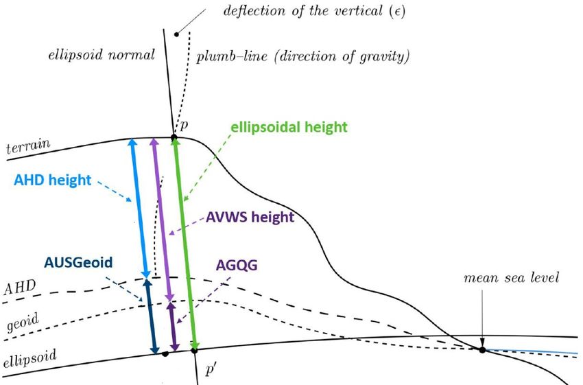
Proceedings of the APAS Webinar Series 2021 (AWS2021)
                                       24 March – 30 June 2021

3.1 Saving AHD

Whilst the role of the Survey Operations group within DCS Spatial Services is to maintain the
State’s survey control network, in the last 10 years it has taken on a more active role in both
POSI and its effort to ‘save’ AHD. To this end, several projects have been undertaken.

3.1.1 Tide Gauge Monitoring

Over the years, DCS Spatial Services has continued to monitor the stability of tide gauges via
precise optical levelling, then digital levelling and recently precise EDM height traversing.
Generally conducted every 2-5 years, these surveys monitor the stability of the tide gauge
compared to a near array of stable marks. Port Kembla tide gauge has been regularly monitored
for over 20 years, while Fort Denison tide gauge has been resurveyed ‘across the gap’ from Mrs
Macquarie’s Point (and then back to the Department of Lands plug in Bridge Street). More
recently, Eden tide gauge has been similarly connected.

Five GNSS Continuously Operating Reference Stations (CORS) were either specifically built
or adopted to augment long-term tide gauges located along the NSW coast in order to support
sea-level monitoring: Fort Denison, Port Botany, Newcastle East, Port Kembla and Eden
(Janssen et al., 2013).

3.1.2 ANLN Level Run Sampling with AUSPOS

In a first dedicated effort, AHD marks were sampled across the entire State, as quickly as
possible, for improvement of the national AUSGeoid model (e.g. Brown et al., 2018;
Featherstone et al., 2019) to provide a better connection between GNSS-derived ellipsoidal
heights and AHD heights. This was conducted in a series of ‘Saving AHD’ AUSPOS survey
campaigns, commencing in 2015 and employing multiple crews from all DCS Spatial Services
survey offices (see sections 3.1.5 & 3.3). In the first pass, each level run was investigated and
sampled. A single field day was invested in each level run, while the longest runs out west (e.g.
Broken Hill to Mildura) were allocated two days. Each crew typically had 5-6 GNSS receivers
that were deployed over the length of the level run, predominately at PMs. Whilst harder to
locate, PMs were believed to be more stable than SSMs. Each mark was maintained (i.e.
cleared, painted and protected using generally 3 painted star pickets), photographed, observed
by an overnight AUSPOS session, and SCIMS was updated with current metadata.

3.1.3 Observing FBMs and GBMs with AUSPOS

Similarly, a dedicated campaign is well underway to find, maintain and AUSPOS the FBMs
and GBMs, recalling that these marks were specifically designed to maintain height, whether it
be AHD, ellipsoidal or even AVWS height.

3.1.4 Recovering Lost Levelling

Noting the high quality and higher expense of good-quality spirit levelling, DCS Spatial
Services has invested significant resources over the last few years in trying to recover lost
levelling. A good example is the first-order levelling from SMA, which included some 1,000
marks over 1,000 km from Cooma to Tumut and on to the Victorian border, surveyed in the
days of the Snowy Mountains Hydro-Electric Scheme (construction from 1949 to 1974).
Unfortunately, none of these marks were ever entered into SCIMS, even though they were
readjusted from the SMA datum to AHD as part of the initial AHD realisation. In fact, until

                                                12
Proceedings of the APAS Webinar Series 2021 (AWS2021)
24 March – 30 June 2021
recently, SCIMS did not include any ANLN levelling between Cooma and Jindabyne. To date,
nearly 15% of these marks have been recovered, maintained and observed by DCS Spatial
Services, which is a great result considering that SCIMS basically held no levelled heights at
all in Kosciuszko National Park, and these marks are now 70 years old.
Over the past few years, DCS Spatial Services has conducted multiple survey campaigns to
recover, maintain and AUSPOS as many surviving marks as possible. Through searching our
archives, we have found fragments of records and used this data to search for what can be found
in the field. Results have been very mixed, and only those marks that were found have been
included in SCIMS for everyone’s benefit. Placed and surveyed as far back as the 1950s, these
marks are again being used, now for the Snowy 2.0 project.
In a similar fashion, DCS Spatial Services continues to recover, on an ad-hoc basis, 1950s
National Mapping Division levelling, observed to support ‘AeroDist’ surveys. As a bonus, this
data is predominately located in remote regions of the State, with level runs reaching out to a
graticule of 1° map corners, which are often located amongst a few scattered salt bushes in the
middle of an outback paddock.
DCS Spatial Services was also planning a similar project to recover RBMs with accurate AHD
heights, installed by the Australian Capital Territory (ACT) at the same time AHD was being
observed. Whilst about 450 of the 1,200 RBMs installed are located in NSW, only a handful
are included in SCIMS. A planned joint project with the ACT Office of the Surveyor-General
to recover these RBMs was cancelled in 2020 due to travel restrictions during the COVID-19
pandemic. The project has now been pencilled in for the 2021/22 financial year.
3.1.5 High Fidelity (HiFi) Saving AHD
In the Central West, DCS Spatial Services is now nearing completion of its HiFi Saving AHD
project. In this area, every rural ANLN mark has been searched for, then maintained and
upgraded (including a 6+ hour AUSPOS session). To date, some 1,200 km of levelling has been
audited and then surveyed, while another 400 km is planned in the next few months (Figure 6).
Figure 6: HiFi Saving AHD in the Central West, showing completed (solid black lines) and planned (broken red
lines) level runs.
13Proceedings of the APAS Webinar Series 2021 (AWS2021)
24 March – 30 June 2021
All work has been conducted via day trips, usually by a single crew, one week of every month
or so. The number of ANLN marks that could be recovered is astonishing and exceeded
expectations, with evidence that some have obviously been used by other surveyors. Whilst it
is pleasing to find and recover such marks, it is disappointing that surveyors have not reported
these finds (e.g. via the NSW Survey Marks Mobile App – see DCS Spatial Services, 2020b),
so they can be shared for everyone’s benefit in SCIMS. DCS Spatial Services is considering
expanding this project to all its other survey offices including Lismore, Coffs Harbour,
Newcastle, Sydney and Nowra.
As part of NSW’s contribution to the development of AUSGeoid2020, DCS Spatial Services
collected over 2,500 extended GNSS datasets (at least 6 hours but generally 12-24 hours
duration for AUSPOS processing) on levelled benchmarks across NSW. These GNSS datasets
informed the geometric (‘sliver’) component of AUSGeoid2020, thereby helping to provide a
much better connection to AHD for GNSS-based height transfer, noting that its predecessor
AUSGeoid09 was based on only 100 such control points in NSW (Janssen and Watson, 2018).
Furthermore, for many of these old benchmarks, GNSS datasets improved their horizontal
position, which was initially obtained by scaling off a map, often resulting in positioning errors
of several hundred metres. This not only improved user access to these benchmarks, but also
allowed preservation efforts to be undertaken (you can only protect a mark if you know where
it is).
DCS Spatial Services continues these datum modernisation efforts through its ongoing ‘Saving
AHD’ campaigns, which commenced in 2015 and have to date yielded almost 900 additional
extended GNSS datasets on levelled benchmarks since the computation of AUSGeoid2020 on
1 February 2018 (Figure 7). While the Intergovernmental Committee on Surveying and
Mapping (ICSM) currently does not plan to update AUSGeoid2020 into the future, these
datasets will be very valuable for the continuing improvement of AVWS (see section 3.5).
Figure 7: GNSS datasets of at least 6 hours duration on levelled marks observed by DCS Spatial Services,
including those contributing to AUSGeoid2020.
14Proceedings of the APAS Webinar Series 2021 (AWS2021)
24 March – 30 June 2021
3.1.6 Digitising Historical Levelling Records
In NSW, AHD is simply a set of numbers printed on some 3,600 cardboard sheets, which are
now safely stored in State Archives after nearly 50 years of living in a filing cabinet in Bathurst.
These levelling cards summarise each level run, including the height differences, orthometric
corrections and distances between adjacent survey marks, and are abstracts of the original field
notes, also stored in Bathurst archives and rarely accessed. At some stage, these AHD values
were manually typed into SCIMS (naturally including unknown typos associated with all
manual data entries), and an electronic master version does not exist. In fact, despite the efforts
by academics and federal agencies over the years, the original AHD values cannot be
reproduced. The value on the card is AHD, warts and all.
Noting the importance of these 3,590 historical levelling cards, detailing the measured and
adjusted height differences between benchmarks and junction points, these cards are
progressively being preserved and digitised. The first and now completed step was to scan all
cards into TIF and PDF versions (Figure 8), safely archived in a digital environment. The intent
was to convert these files to smart digital files, but unfortunately Optical Character Recognition
(OCR) failed. Therefore, each card was manually converted to Excel files (one per level run),
which was an enormous and time-consuming task but well worth the effort. Quality assurance
of this manual data entry process is currently underway, using a dozen different manual and
automated checks.
Figure 8: Scanned levelling card for ‘primary’ first-order level run between Dubbo (JP 359) and Wellington (JP
358).
15Proceedings of the APAS Webinar Series 2021 (AWS2021)
24 March – 30 June 2021
Once complete, the values in SCIMS can themselves be checked to remove any typos that have
lain dormant for decades. Using all original ANLN levelling, supplemented with all digital
levelling archived from internal and external organisations, combined with 3D GNSS
observations and a much improved AUSGeoid2020 (e.g. Brown et al., 2018; Janssen and
Watson, 2018; Featherstone et al., 2019), we can then, in the future, detect and correct AHD
blunders and issues. All data will be combined into the ‘all-in-one’ state adjustment and
complement each other. The enormity of this task and its outcomes should not be
underestimated. While Victoria has already completed a state-wide levelling adjustment, other
jurisdictions are now also commencing similar projects.
It should be emphasised that there are no plans to readjust (or re-realise) AHD. Under the
original rules, jurisdictions cannot modify the height of junction points without federal approval
(e.g. Lands, 1974, 1976; NMC, 1979). The height of intermediate marks can be updated if a
blunder or mark movement is detected and proven, which is part of the day-to-day maintenance.
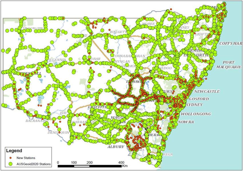
3.1.7 Building the NSW Levelling Adjustment
Together with the results of data-mining existing levelling files in the DCS Spatial Services
archive, the digitised historical levelling data is being used to generate a single, state-wide
levelling adjustment for NSW. Whilst this work is still ongoing, it is clear that it will provide
huge benefits to surveying and spatial professionals in regard to accessing height information
across the State. As of March 2021, the NSW levelling adjustment comprises about 132,000
measurements and 98,000 stations (Figure 9).
Figure 9: Location of benchmarks included in the NSW levelling adjustment.
16Proceedings of the APAS Webinar Series 2021 (AWS2021)
24 March – 30 June 2021
3.2 GNSS Technology
The next challenge for AHD is technology itself, i.e. is AHD still fit for purpose? The era of
GNSS technology ushered in the development of geoid or quasigeoid models to convert GNSS-
derived ellipsoidal heights to physical heights. This conversion is often needed because
positions obtained by GNSS (e.g. GPS, GLONASS, BeiDou, QZSS and Galileo) include
heights referred to a reference ellipsoid. These heights are based purely on the geometry of the
ellipsoid and therefore have no physical meaning, i.e. they cannot be used to predict the
direction of fluid flow because they do not consider changes in gravitational potential. In
practice, however, heights are generally required that correctly reflect the flow of fluids, e.g.
for drainage and pipeline design.
Following national datum modernisation efforts, these AUSGeoid models have improved over
time. The first, AUSGeoid91, was released in 1991, soon followed by AUSGeoid93 and then
AUSGeoid98. These predominantly gravimetric-only quasigeoids were incorrectly assumed to
be sufficiently close approximations of AHD. Correcting this oversight and delivering a more
user-driven product, AUSGeoid09 was the first combined gravimetric-geometric quasigeoid,
providing a more direct connection to AHD and thereby allowing a more reliable determination
of AHD heights from GNSS observations (Brown et al., 2011). The geometric component (or
‘sliver’) basically constitutes a grid of quasigeoid-AHD separation values, empirically derived
from collocated GNSS ellipsoidal heights and levelled AHD heights (see Figure 7). In effect,
the gravimetric quasigeoid model is warped and distorted to fit the AHD using GNSS-levelling
data, accounting for the offset between the quasigeoid and AHD (about -0.3 m to +0.2 m across
NSW).
The most recent model is AUSGeoid2020 (e.g. Brown et al., 2018; Janssen and Watson, 2018;
Featherstone et al., 2019), to be used only in conjunction with GDA2020 ellipsoidal heights.
Due to the biases and distortions inherent in AHD, AUSGeoid2020 is only capable of providing
GNSS-derived AHD heights with an official accuracy of 6-13 cm across Australia (ICSM,
2020b), although it has been shown that AUSPOS-derived AHD heights in NSW can be much
better than reported (Janssen and McElroy, 2020). In layman’s terms, we have now reached a
stage where whilst we can measure with unprecedented accuracy, what we are measuring from
(ground zero, or our origin) is a magnitude less accurate. Our flat playing field is in fact a
crumpled-out piece of paper that has been ironed flat, with some evidence of crinkles remaining.
In order to address the shortcomings of AHD in an era of ever-increasing usage and availability
of GNSS observations and airborne gravity measurements, work commenced to investigate
options for a potential new vertical datum (e.g. Featherstone, 2008; Filmer and Featherstone,
2012). This culminated in the development of the Australian Vertical Working Surface
(AVWS) as an alternative for advanced users and early adopters requiring higher-quality
physical heights than those AHD can provide (see section 3.5). AVWS allows users to realise
the full potential of modern technology in order to make height determination and transfer more
efficient than with the traditional techniques used in the 1970s and 1980s.
3.3 Recent Datum Modernisation Efforts in NSW
DCS Spatial Services is responsible for the maintenance of the State’s survey control network.
Datum modernisation and further improvement of survey infrastructure is required to
accommodate the increasing accuracy and improved spatial and temporal resolution available
from modern positioning technologies such as GNSS to an ever-broadening user base.
17Proceedings of the APAS Webinar Series 2021 (AWS2021)
24 March – 30 June 2021
This has led to the establishment of CORSnet-NSW, Australia’s largest state-owned and
operated GNSS CORS network (e.g. Janssen et al., 2016; DCS Spatial Services, 2021).
CORSnet-NSW is not only the backbone of GDA2020 across the State but also provides
fundamental positioning infrastructure that is authoritative, accurate, reliable and easy-to-use
for a wide range of applications. Furthermore, with all sites contributing to AUSPOS, it
comprises a fundamental, high-density and long-term component of AUSPOS infrastructure
within the State (Janssen and McElroy, 2020).
Consequently, the use of AUSPOS campaigns has developed into a capable and reliable
alternative to conducting traditional static GNSS baseline surveys, simplifying field work
logistics and reducing processing times. This has substantially accelerated the process of
including additional survey marks into the GDA2020 state adjustment in order to improve user
access to GDA2020 coordinates and uncertainties on public record through SCIMS (e.g.
Gowans et al., 2015; Janssen and McElroy, 2020). As discussed in section 3.1, AUSPOS has
become the primary survey technique used by DCS Spatial Services to ‘save’ AHD.
In support of these datum modernisation efforts, DCS Spatial Services is currently building an
updated ‘passive’ survey control network (in the Eastern and Central Divisions) with a
minimum of one fundamental survey mark observed by 6+ hour AUSPOS every 10 km. Its
vision is to ensure that any future user is no further than 5 km (and often much less) from such
a fundamental mark providing direct connection to datum. Similarly, levelled AHD marks are
observed by 6+ hour AUSPOS every 10 km, often at a far greater density up to every mile (see
section 3.1.5). This will allow users to achieve DCS Spatial Services’ vision of a Positional
Uncertainty (PU) of 20 mm in the horizontal and 50 mm in the vertical (ellipsoidal height)
component anywhere in the State and easily apply transformation tools to move between
current, future and various historical datums and local working surfaces (e.g. Standard Datum
or Railway Datum).
3.4 Gravity Matters!
3.4.1 Australian Vertical Datum Modernisation Efforts
Several countries have used, or are about to use, (nationwide) airborne gravity measurements
to develop high-quality gravimetric quasigeoid models in order to modernise their national
vertical datums. For example, this includes:
• Canadian Geodetic Vertical Datum 2013 (CGVD2013 – Véronneau and Huang, 2016).
• New Zealand Vertical Datum 2016 (NZVD2016 – McCubbine et al., 2018).
• North American-Pacific Geopotential Datum 2022 (NAPGD2022 – NGS, 2007, 2017).
Gowans (2019) summarised the reasons for moving to vertical datums based on gravimetric
quasigeoids as follows: The maintenance of national levelling networks is no longer viable
because they are too costly, too time consuming, and the results are too short-lived in countries
subject to significant surface displacement. Gravimetric quasigeoid models are far more cost
effective to maintain and less susceptible to surface movements. Their complete spatial
coverage provides significant efficiency gains for industry when accessing the datum because
propagating the datum from the nearest levelled benchmark(s) is no longer required. Basically,
the datum is available everywhere, so there are no more ‘black holes’ as in AHD. However,
digital levelling is still considered the most accurate technique for height transfer across short
distances and will retain relevance in surveying for height-critical, local-scale projects. Since a
18Proceedings of the APAS Webinar Series 2021 (AWS2021)
24 March – 30 June 2021
model can only ever be as good as the data that informs it, the systematic acquisition of
nationwide airborne gravity has proven to significantly benefit these quasigeoid models.
In Australia, efforts are underway to collect airborne gravity data over targeted regions in, for
example, South Australia and Victoria (Figure 10) to improve the Australian gravimetric
quasigeoid model. The objective is to collect consistent and evenly distributed gravity
measurements with minimal disturbance to land users and the environment, using specialised
gravity-sensing instrumentation to measure extremely small variations in the Earth’s natural
gravitational pull. In Victoria, such airborne gravity surveys have already been successfully
completed across coastal Gippsland (2011), south-west Victoria (2019) and near Bendigo (2004
and 2019) (VIC Government, 2020). DCS Spatial Services is currently preparing a business
case for the modernisation of the Foundation Spatial Data Framework (FSDF), which includes
an option to secure funding for airborne gravity surveys across the entire State.
New airborne gravity data will significantly improve the gravity (and gravimetric quasigeoid)
model and thus the accuracy of GNSS-derived physical heights. The gravity data will also be
used by geoscientists to further their understanding of Australia’s geological ‘architecture’ and
how it has evolved over time, as well as advance the geoscience that assists management of
earth resources, infrastructure and natural hazards.
Figure 10: Targeted airborne gravity survey areas in (a) South Australia and (b) Victoria (SA Government, 2020;
VIC Government, 2020).
3.4.2 Airborne Gravimetry: Theory and Data Acquisition
Gravity is a rather complex topic that most surveyors will not have embraced since their
university days. This section provides some technical background information for those who
wish to learn a little more about airborne gravimetry and reacquaint themselves with the
fascinating world of physical geodesy.
Gravity is the force acting on a body on or near the Earth’s surface, which is a combination of
the gravitational force (the force of attraction between two masses) and the centrifugal force
(the apparent force caused by the uniform circular motion of a body about a fixed point) of the
Earth’s rotation. In the absence of friction and other forces, it is the rate at which objects will
19Proceedings of the APAS Webinar Series 2021 (AWS2021)
24 March – 30 June 2021
accelerate towards each other. At the surface of the Earth, gravity (acceleration) is
approximately 9.8 m/s2, with absolute gravitational acceleration varying across Australia
between 9.780 m/s2 in northern Australia and 9.805 m/s2 in southernmost Tasmania (Kennett
et al., 2018).
In principle, gravity is measured using an accelerometer (although, technically, the
accelerometer only senses action forces and not gravitational forces), which houses a proof
mass that is restricted to movement along a sensitive axis and a restraining device (e.g. a spring).
The mass is supported by the restraining device and displaces with respect to an equilibrium
position when subject to acceleration. Knowing the relationship between the displacement and
the restoring force applied to the mass, the accelerometer provides a measure of the force
required to counter the force due to accelerations acting on the mass. Gravity is generally
measured in units of Gal (1 cm/s2 or 0.01 m/s2) or mGal (0.001 cm/s2).
An absolute gravity meter (or gravimeter) measures gravity at a single location, which is
currently restricted to ground-based acquisition. It determines the actual value of the
gravitational acceleration, generally by measuring the speed of a falling mass in vacuum using
a laser beam and optical interferometry. A relative gravimeter is much more common and
measures the difference in gravity between two locations via ground-based, shipborne, airborne
or satellite-based acquisition, generally using a spring supporting a proof mass. In order to be
truly effective, surveys carried out with relative gravimeters must include acquisition at one or
more sites where absolute gravity is known (e.g. at the airport and in the area of interest for
airborne gravimetry). Today’s airborne gravimetry systems can be separated into traditional
airborne gravity systems and gradiometer systems.
Airborne gravity systems measure a combination of aircraft accelerations and the Earth’s
gravitational field. Consequently, most of the design and processing is aimed at maintaining the
gravity sensing unit in a vertical orientation and accurately measuring the aircraft’s
corresponding vertical movement using differential GNSS velocities. Commercial gravimeters
utilise gyro-stabilised platforms to maintain the vertical orientation. In simple terms, subtracting
the GNSS-derived vertical accelerations of the aircraft from the total vertical gravity measured
by the instrument will provide residual gravity. In practice, additional corrections are required,
e.g. to account for platform misalignment (tilt), lever arm (spatial relationship between the
GNSS antenna, airborne gravimeter and any other equipment used within the aircraft),
horizontal accelerations, drift, Eötvös effect (change of the centrifugal force of the Earth’s
rotation due to being on a moving platform) and minor temperature and pressure variations
(Wooldridge, 2010).
The reduction of airborne gravity data requires the use of low-pass filters because the long- to
medium-wavelength signal is of interest, while most noise has a short wavelength (i.e. high
frequency). The effective resolution of the system is generally equated to the half-wavelength
of the filter multiplied by the speed of the aircraft (consequently, half-wavelength filter lengths
are often quoted rather than the full-wavelength filter). By shortening the filter length, the
system resolution is improved at the expense of accuracy (Wooldridge, 2010). Factors
influencing resolution and accuracy include aircraft speed, altitude and the spacing of flight
lines. While precision from airborne data can be assessed well (using repeat tracks, adjacent
tracks, crossovers or grid comparisons), accuracy is much harder to determine (using models,
satellite data or ground data) because the true value is not really known, although good global
models are available (Preaux, 2016).
20Proceedings of the APAS Webinar Series 2021 (AWS2021)
24 March – 30 June 2021
Airborne gravity gradiometer systems measure, in principle, the gradient of the Earth’s
gravitational field independent of aircraft accelerations. The two current commercial airborne
gravity gradiometer systems providing high-resolution gravity gradiometer data are the
Airborne Gravity Gradiometer (AGG), known as the ‘Falcon’ system, and the Full Tensor
Gradiometer (FTG). Both utilise spinning discs equipped with multiple accelerometers, which
measure two or more components of the gravity gradient tensor depending on the number of
discs present and their orientation. The gradients measured at different locations are
transformed to vertical gravity. Gravity gradients are measured in units of Eötvös (Eö), where
1 Eö = 10-9/s2 = 0.1 mGal/km, i.e. a variation of 1 mGal/km is 10 Eö (Fairhead et al., 2017).
Airborne gravity gradiometer systems are generally more accurate (higher resolution) and more
robust than traditional airborne gravimetry, but also much more expensive. They must detect
very small differential gravitation signals over a short baseline. This requires accounting for
errors such as scale factor errors (accelerometers are not perfectly matched), alignment errors
(sensitive axes of the accelerometers are not parallel), asymmetry of the configuration
(measurement point is not the centre of mass of the accelerometer pair) and self-gradients (the
gradient field is changed due to the rotation of the aircraft about the stabilised platform hosting
the instrument), which is mostly achieved through calibration and filtering (Jekeli, 2003).
3.5 AVWS
The Australian Vertical Working Surface (AVWS) is a new reference surface for physical
heights in Australia, released on 1 January 2020 to provide a height reference surface that works
seamlessly onshore and offshore, is directly compatible with GNSS, continuously improved
over time and more accurate than AHD because it does not suffer from the biases and distortions
present in AHD. In practical terms, AVWS provides an alternative for users requiring higher-
quality physical heights (current accuracy about 4-8 cm) than those AHD can provide (accuracy
about 6-13 cm) (ICSM, 2020b).
GNSS users can access AVWS by applying the Australian Gravimetric Quasigeoid (AGQG)
model to their GDA2020 ellipsoidal heights, just like AUSGeoid2020 is used to obtain AHD
heights. In practice, this means simply picking model ‘B’ instead of the usual model ‘A’ in your
GNSS processing software or the GNSS rover during real-time (RTK/NRTK) surveys. The
initial version, AGQG_2017 (Featherstone et al., 2018), is the gravimetric component of
AUSGeoid2020, providing the offset between the ellipsoid and the quasigeoid without being
contaminated by the distortions inherent in AHD.
The current version of AGQG (AGQG_20201120) differs from AUSGeoid2020 by between -
1.8 m and +0.7 m across Australia, resulting in AVWS (normal) heights differing from AHD
(normal-orthometric) heights by the same amount when determined via GNSS and the
respective models (J. McCubbine, pers. comm.). In NSW, users can expect differences of
between -0.5 m and +0.1 m (Figure 11). Geoscience Australia is working with all jurisdictions
to continuously improve AGQG as new gravity data (particularly airborne gravity) is included
and modelling techniques are refined.
21Proceedings of the APAS Webinar Series 2021 (AWS2021)
24 March – 30 June 2021
Figure 11: Differences in N values between AGQG_20201120 and AUSGeoid2020 across NSW, which is
equivalent to the differences between AVWS heights and AHD heights.
Recently, a FrontierSI project investigated current and future user requirements for physical
height determination and transfer in Australia (Brown et al. 2019a, 2019b; McCubbine et al.,
2019). It was found that AHD is still deemed fit for purpose over short distances (less than
about 10 km) for applications such as cadastral surveying, civil engineering, construction and
mining. However, users working over larger areas wanted access to higher-quality heights to
reap the full benefits of modern technology for environmental studies (e.g. flood or storm
modelling), Light Detection and Ranging (LiDAR) surveys, geodesy or hydrography projects.
The study concluded by recommending a two-frame approach for heights, with AHD remaining
as Australia’s legal datum and AVWS being provided as an alternative, analogous with the two-
frame approach taken with GDA2020 (ICSM, 2020a) and ATRF2014 (ICSM, 2020c). In
practice, the surveyor and client would choose which one to use for a particular job, considering
relevant legislation that may apply.
From a user perspective, AVWS provides improved access to physical heights, higher accuracy,
increased efficiency, a surface without the known gross, random and systematic errors of the
levelling network, better alignment with GNSS, and national consistency including a seamless
onshore-offshore transition. GNSS-derived ellipsoidal heights are converted to AVWS heights
by applying the AGQG model (i.e. option ‘B’ from above), in the same way that they are
converted to AHD heights using the AUSGeoid model (Figure 12). Given that AVWS heights
are not (currently) provided for benchmarks on public record, these AVWS heights can then be
used as reference heights or starting points for spirit levelling surveys. While normal corrections
should theoretically be applied to levelled height differences, this can generally be neglected in
practice at the cost of introducing a small amount (sub-mm) of error (ICSM, 2020b).
22Proceedings of the APAS Webinar Series 2021 (AWS2021)
24 March – 30 June 2021
Figure 12: Converting ellipsoidal heights (green) to AHD heights (light blue) by subtracting the AUSGeoid
model (dark blue) and to AVWS heights (light purple) by subtracting the AGQG model (dark purple) (ICSM,
2020b).
It should be noted that other vertical working surfaces or local vertical datums exist, e.g. the
Lowest Astronomical Tide (LAT) used for hydrographic applications. Whilst these are out of
scope for this paper, it is important to note that multiple height reference surfaces have been
used in Australia for a long time to cater for certain applications. The introduction of AVWS
simply adds to the spatial professional’s toolbox but also highlights the importance of metadata
clearly specifying which datum or reference surface you are working in.
4 THE FUTURE
Whilst written nearly half a century ago, Blume (1975) noted “With the adoption in New South
Wales of the Australian Height Datum (AHD) 1971 as a new levelling datum, the previously
used Standard Datum has been superseded. The small difference between the two datums has
resulted in many surveyors being vocally critical of the new datum and the opinion has been
expressed that the introduction of AHD was an unwarranted alteration to a long established
and acceptable system.” He continued: “Further investigation in connection with AHD is
certain to continue and as a result of such research into tides, levelling, mathematical
adjustments and revision, new values and possibly datums will arise. Because of the ever-
changing level of the sea, any new datum would not necessarily agree with AHD, just as AHD
did not agree with Standard Datum, which in turn did not agree with former datums based on
sea levels. However, the need to replace AHD will doubtless require deep consideration in
order to produce very strong and compelling reasons.”
These sentiments are just as true today, and his crystal-ball wisdom about the debate the
profession will soon begin in regard to AHD and AVWS is visionary. A testimony to its true
quality and immense expense, AHD has long outlasted its horizontal datum counterparts (i.e.
AGD66, AGD84, GDA94), and it is unlikely that GDA2020 will still be operating in another
23You can also read