The Intercontinental Chemical Transport Experiment - Phase B (INTEX-B): An update
←
→
Page content transcription
If your browser does not render page correctly, please read the page content below
The Intercontinental Chemical Transport Experiment – Phase
                     B (INTEX-B): An update

           H. B. Singh1, W. H. Brune2, J. H. Crawford3, H. Fuelberg4, D. J. Jacob5
1
NASA Ames Research Center, 2Penn State University; 3NASA Langley Research
Center, Hampton; 4Florida State University; 5Harvard University

                                       ABSTRACT
         INTEX-NA* (http://cloud1.arc.nasa.gov) is a two phase experiment that aims to
understand the transport and transformation of gases and aerosols on
transcontinental/intercontinental scales and assess their impact on air quality and climate.
The primary constituents of interest are ozone and precursors, aerosols and precursors,
and the long-lived greenhouse gases. The first phase (INTEX-A) was completed in the
summer of 2004 and the second phase (INTEX-B) is to be performed in the spring of
2006. This document is intended to provide an update on the goals of INTEX-B and
define its implementation strategy. The scientific goals envisioned here are based on the
joint implementation of INTEX-B, MIRAGE-Mex (h t t p : / / m i r a g e -
mex.acd.ucar.edu/index.html) and DLR/IMPACT studies and their coordination with
satellite observations. In collaboration with these partners, the main goals of INTEX-B
are to:

        - Quantify the transpacific transport and evolution of Asian pollution to North
America and assess its implications for regional air quality and climate;
        - Quantify the outflow and evolution of gases and aerosols from the Mexico City
Megaplex;
        - Investigate the transport of Asian and North America pollution to the eastern
Atlantic and assess its implications for European air quality;
        - Validate and refine satellite observations of tropospheric composition;
        - Map emissions of trace gases and aerosols and relate atmospheric composition
to sources and sinks

        The INTEX-B field study is to be performed during an approximate 8-week period
from March 1 to April 30, 2006. The first part of the study (INTEX-B/Part I) will be
performed during March 1-31 and will focus on Mexico City pollution outflow while the
second part (INTEX-B/Part II) will be performed during April 1-30 and will focus on
Asian pollution inflow. Several national and international partners are expected to join
with INTEX-B and its scope is likely to expand in the coming months. At the moment,
the principle INTEX-B partners are the NSF led MIRAGE-MEX and the German/DLR
led IMPACT. Both high flying (e. g. the NASA DC-8 and DLR Falcon-20) and low
flying (e. g. NSF/NCAR C-130) airborne platforms are expected to be available for
INTEX-B. These airborne platforms, with possible augmentations by others, will be
equipped to perform a comprehensive suite of gas, aerosol and radiation measurements.
_______________________________________________________________
* See Appendix for explanation of Acronyms

                                            1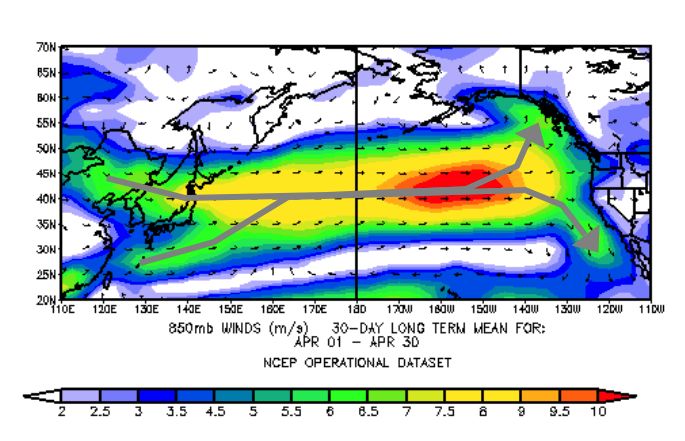
This study is planned assuming that approximately 180 flight hours will be
available for each of the major airborne platforms such as the NASA DC-8 and the
NSF/NCAR C-130. Principal operational sites and dates for the spring 2006 activity are
tentatively selected to be:

     - NASA DC-8 (Houston, TX/March 1-31; Hilo, Hi/April 1-12; Anchorage,
AK/April 13-30)
     - NSF/NCAR C-130 (Tampico, MX/March 1-31; Seattle, WA/April 1-30)
     - DLR Falcon-20 (Oberpfaffenhofen, Germany/April 1-30)

        To expand the temporal and spatial scale of airborne measurements, INTEX-B
will closely coordinate its activities with satellites platforms especially Aura, Aqua,
Terra, and Envisat. A majority of the “standard” and “research” products to be retrieved
from satellite observations will be measured during INTEX-B. Validation of satellite
observations of tropospheric composition will receive high priority. Central to achieving
INTEX-B objectives is the ability to relate space-based observations with those from
airborne and surface platforms. The overall experiment will be supported by forecasts
from meteorological and chemical models, satellite observations, surface networks, and
enhanced O3-sonde releases.
        In addition to understanding the life-cycle of pollutants downwind of large
sources regions, INTEX-B will allow us to test and improve the present capability of
chemical transport models and help to advance their integration with space-based,
airborne, and surface-based observing systems. Joining resources, the spring 2006 field
experiments will greatly add to our ability to quantify pollution transport and its
evolution from local to intercontinental scales. Participation by researchers from
academia, government labs, and other research institutions is essential for the success of
this campaign.

                                           2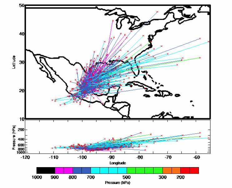
I. BACKGROUND
        A central component of NASA’s grand vision in Earth Sciences is to understand
how the Earth’s atmosphere is changing and what are the consequences of this change?
As has been stated in the original INTEX-NA white paper (Singh et al., 2002;
http://cloud1.arc.nasa.gov), a key requirement in addressing this vision is the availability
of the necessary observational data. In recent years airborne experiments, complemented
by satellite derived measurements, have been undertaken around the globe to develop
these data sets along with the associated interpretive framework. These studies have been
driven by two overarching goals:

       (1) To improve our understanding of sources and sinks of environmentally
       important gases and aerosols through the constraints offered by atmospheric
       observations; and
       (2) To understand the linkages between chemical source regions and the global
       atmosphere, and the implications of human influence on climate and air quality

        The export of air pollutants from urban to regional and global environments is a
major concern because of wide-ranging consequences for human health and ecosystems,
visibility degradation, weather modification, changes in radiative forcing, and
tropospheric oxidation (self-cleaning) capacity. The complexities involved in quantifying
the role of long-range pollution transport on environmental degradation have led to the
launching of an international research initiative (IGAC-ITCT;
http://www.igac.noaa.gov/ITCT.php). INTEX-NA is a NASA led integrated field
experiment within the IGAC-ITCT initiative with the goal of understanding the transport
and transformation of gases and aerosols on transcontinental/intercontinental scales and
assessing their impact on air quality and climate. Its first phase (INTEX-A) was
completed in the summer of 2004 and its second phase (INTEX-B) is to be performed in
the early spring of 2006. Although the main features of INTEX-B were discussed in the
original INTEX-NA white paper, much has transpired during the last three years to make
an update necessary. In this document, we focus on those aspects that are most relevant
to the conduct of the upcoming INTEX-B field mission.

                       II. INTRODUCTION AND OVERVIEW
        In recent decades a mounting body of atmospheric data have shown that gas and
aerosol pollutants are routinely transported on intercontinental scales and can influence
air quality and regional climate in downwind regions (Holloway et al., 2003; Stohl, 2004;
JGR-Atmospheres 2004a,b). Multiple studies have documented the transport of Asian
pollution to North America (Jaffe et al., 1999; Jacob et al., 1999; VanCuren, 2003) and
Europe (Lelieveld et al., 2002). This transport is initiated by cold frontal passages over
eastern Asia, which lift continental boundary layer air to the free troposphere where it is
then carried towards North America by the westerlies. Subsidence of this Asian air over
North America then takes place behind cold fronts. Transpacific transport is highly
episodic but most frequent and rapid in spring, when frontal activity is maximum and the
atmospheric circulation is strong (Yienger et al., 2000). There is however, evidence to
suggest that Asian influences are not limited to the spring period and are present
throughout the year (VanCuren et al., 2004; INTEX-A unpublished data). Dramatic

                                            3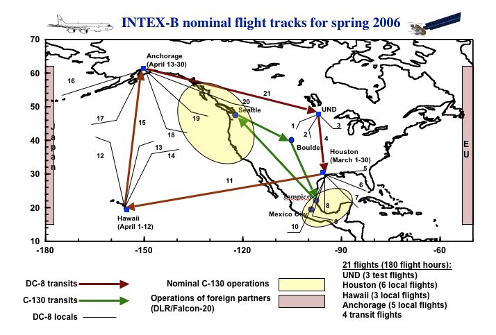
evidence for transpacific transport of Asian air to North America is offered by Asian dust
plumes, which have been tracked by satellites across the ocean and found to cause large-
scale exceedances of air quality standards at sites in the western United States (Husar et
al., 2001). Asian pollution plumes have also been observed from aircraft and at ground
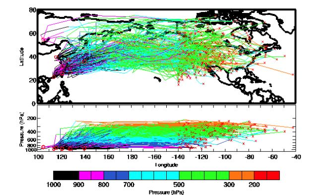
sites along the west coast. Figure 1 shows a schematic of Asian air transport for the
month of April along with 7-day climatological trajectories derived from a 15-year
(1979-1993) global data set prepared by Eckhardt et al. (2004). Approximately 10% of
all Asian trajectories crossed 140W longitude within 7 days enroute to North America.
An example of an Asian pollution outflow event is shown in Figure 2. A major
Asian outflow pollution event occurred in February 2001 and was monitored by the
MOPITT satellite, which measures total CO column abundance, and by the NASA DC-8,
which was on its transit through Hawaii at the beginning of the TRACE-P mission (Heald
et al., 2003). The plume (dark gray) is over Japan on 23 February and splits around a
blocking high pressure region east of Hawaii. The northern branch was detected by the
DC-8 between Hawaii and California at 6-8 km; the southern branch was detected
southwest of Hawaii at 4-5 km the next day. Aircraft observations show quite different
chemical evolution in the two plumes, with PAN dissociation in the southern plume
resulting in O3 production.
Both observational data and modeling studies have shown that the composition of
the inflow to NA and Europe may have changed due to intercontinental pollution
influences (Jaffe et al., 2003; Parrish et al., 2004; Simmonds et al., 2004). It has been
suggested that surface O3 levels entering the US and Europe may have increased by as
much as 0.5 ppb/year (Figure 3) over the last two decades. There is increasing concern
that efforts to improve air quality in the United States through domestic emission controls
could be thwarted by Asian industrialization and the associated transpacific transport of
pollution. However, there is still considerable uncertainty as to the importance of this
transpacific transport and its relevance for surface air quality in the United States.
A second phenomenon that is receiving much attention in recent years is the
impact of pollution from megacities (>10 million population) (http://mirage-
mex.acd.ucar.edu/; http://www.igac.noaa.gov/MEGACITY.php). With a current
population of ca. 18 million, Mexico City is one of the world’s most populous tropical
cities with unique emission characteristics (Molina and Molina, 2002). Three-day
forward trajectories released from Mexico City for the month of March are shown in
Figure 4. Some 30-50% of these trajectories reach the continental U. S. within 3-5 days.
MIRAGE-Mex is an experiment designed to address major uncertainties in the transport,
physical and chemical transformations, and evolving radiative properties of gases and
aerosols. The focus will be on understanding the life-cycle of these pollutants, from
emission to ultimate removal from the atmosphere, and especially the “middle-age”
transition from urban to regional and global scales.
INTEX-B and MIRAGE-mex are planning to join forces to investigate both the
“inflow of pollution to NA from Asia” as well as the outflow and evolution of pollution
from “Mexico City”. The long range and high altitude capability of the DC-8 and the
superior low altitude capability of the C-130 greatly add to the overall experiment.
Combining MIRAGE-Mex and INTEX-B enables the examination of long-range
pollution from both the south/southwest and the northwest in a single study. The many
advantages of this collaboration have been discussed in detail by Brune et al. (2004).
4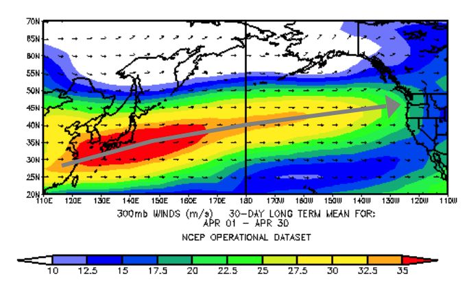
Figure 1: 300 mb winds (top), 850 mb winds (middle) and 7-day forward Asian
trajectories (bottom) for the month of April. Trajectories (one per day) were released
from 500 meters AGL from Irkutsk, Hong Kong, Shanghai, Taipei, Seoul, Beijing,
Okinawa, Tokyo (red circles). Alternate day trajectories that were east of 140W in 7
days (approx. 10%) are shown. The trajectories are from a global 15-year data set
prepared by Eckhardt et al. (2004)

                                         5
23 February 2001 25 February 2001 27 February 2001
Figure 2. Model simulation of an Asian pollution plume (indicated by CO column
abundance and consistent with MOPITT satellite CO column measurements) crossing the
Pacific during the TRACE-P study in February 2001.
Fig. 3. Surface ozone trends in air flowing into the United States and Europe. Top
Panel (Jaffe et al., 2003): Spring time ozone mixing ratios from selected sites on
the west coast of united states show a mean trend of 0.5 ± 0.4 ppb/yr. Bottom
Panel (Simmonds et al., 2004): Mace Head O3 baseline monthly means from 1988-
2003. Mean annual trend is 0.5 ± 0.2 ppb/yr with largest trend in winter (0.6 ± 0.3
ppb/yr ) and smallest in summer (0.4 ± 0.3 ppb/yr).
6Figure 4: Three day forward trajectories from Mexico City for the month of March.
Approximately 30% of these are over the United States in 3 days. The trajectories are
from a global 15-year data set prepared by Eckhardt et al. (2004).
The scale of the intercontinental transport problem is extremely large and until
recently the means to investigate this problem were inadequate. A major new advance
has been the launch of new satellite instruments that have the capability to map pollution
in the troposphere on regional to global scales (Borrell et al., 2004; Schoeberl, et al.,
2004). Table 1 provides a partial list of key chemical and physical properties of interest
to INTEX-B that can be measured by satellite instruments in the troposphere. Some of
these instruments (e. g. TES, MIPAS) have great potential to also measure a large
number of organic chemicals as research products (Beer et al. 2001, Allen et al., 2004).
During INTEX-A a large number of satellite under-flights were performed to test and
validate the accuracy of satellite observations from MOPITT, MISR, AIRS, and
SCIAMACHY (Figure 5). These validation flights were specifically targeted in space
and time to provide a large body of coincident data on gases and aerosols to both test and
further refine satellite derived products of tropospheric composition. INTEX-B will
perform the dual role of validating satellite observations in the troposphere as well as
integrating them with in-situ observations to address stated scientific goals.
7Table 1: Satellite observations of key tropospheric constituents relevant to INTEX-B
Satellite Platform* Instruments Some key data products Vertical
resolution
Aura: TES CO, CH4, O3, HNO3, NO2 Trop column/4 km
http://eos-aura.gsfc.nasa.gov/ OMI O3, NO2, SO2, HCHO Trop column
MLS H2O, HCN UT/LS
Aqua: MODIS Aeorosol optical depth Trop column
http://eos-pm.gsfc.nasa. gov/ AIRS CO Trop column/4 km
Terra MOPITT CO Trop column/4 km
http://eos-am.gsfc.nasa.gov/ MISR Aeorosol optical depth Trop column
MODIS Aeorosol optical depth Trop column
Envisat: SCIAMACHY O3, NO2, CH2O Trop column
http://envisat.esa.int/ MIPAS Trace organics UT/LS
Calipso: CALIOP Aeorosol distribution High resolution
http://www-
calipso.larc.nasa.gov/
*Individual web sites provides detailed measurement capabilities of these instruments
Figure 5: DC-8 satellite under-flights during INTEX-A. Aqua - Red circles; Terra -
green circles; Envisat – amber squares. Typically these involved DC-8 spirals from 11
km to surface within ±30 minutes of satellite overpass and within the swaths of AIRS
(Aqua), MOPITT and MISR (Terra), and SCIAMACHY- Nadir mode (Envisat)
instruments.
8III. SCIENTIFIC OBJECTIVES
INTEX-B is an intensive observational mission involving multiple partners with
overlapping scientific objectives. The achievement of its objectives requires an integrated
observational strategy and a hierarchy of global/regional models. Joining resources and
capabilities with the MIRAGE-mex, DLR/IMPACT, and satellite partners, the following
goals are envisioned:
(1) Characterize and quantify the transpacific transport and evolution of Asian
pollution (gases and aerosols) to North America and assess its implications for regional air
quality and climate;
(2) Characterize and quantify the outflow and evolution of gases and aerosols from
the Mexico City Megaplex;
(3) Investigate the transport of Asian and North America pollution to the eastern
Atlantic and assess its implications for European air quality;
(4) Validate and refine satellite observations of tropospheric composition;
(5) Map emissions of trace gases and aerosols and relate atmospheric composition
to sources and sinks
A critical task towards the achievement of INTEX-B objectives will be inter-comparison
of observations among multiple airborne and satellite platforms in order to generate a
seamless data set. Other key tasks will include characterization of air masses entering the
United States from its western and southern boundaries; and the comparison of measured
chemical fields with those forecasted by regional/global models. Central to achieving
INTEX-B objectives will be the ability to relate space-based observations with those
from airborne and surface platforms. Theories of photochemical ozone and aerosol
production and loss in background and polluted air masses will be tested and the role of
aerosols in radiative forcing and heterogeneous chemistry investigated. The focus will be
on understanding the life-cycle of pollutants several days downwind of the source
regions. Secondary goals will be to:
- Test the ability of models, both forecast and analysis, to capture the timing,
morphology, and altitude of pollution plumes;
- Test the expected chemical evolution of gases and aerosols as the pollution plumes are
transported
- Examine characteristics of the pollution that can affect its direct and indirect effects on
climate;
- Advance the development of the integration between chemical transport models and the
observing system, which includes satellites, ground-based networks, and intensive field
campaigns.
IV. INTEX-B Mission Plan
INTEX-B will use the NASA DC-8 as its primary platform (ceiling 12 km,
endurance 10 hours, nominal speed 400 kts). Complementing this will be the
NSF/NCAR C-130 (ceiling 7 km, endurance 8 hours, nominal speed 300 kts ) and the
DLR Falcon-20 (ceiling 14 km, endurance 5 hours, nominal speed 400 kts). Mission plan
will emphasize coordination between aircraft measurements, satellite observations, and
9models in the pursuit of the mission objectives. The strategy will build on the previous
experience from a number of missions such as TRACE-P, ACE-Asia, and most recently
INTEX-A. Mission design and day-to-day flight operations will be guided by forecasts
from a hierarchy of global and mesoscale models. Near-real-time observations from a
number of satellite instruments will also be used to guide the execution of the mission
and to identify specific regions of interest for in-situ sampling. Integration of aircraft and
satellite measurements to address the mission objectives will require validation flights
directed at establishing the consistency between the two data sets. Collaborations with
partner missions will be pursued actively. Modes of collaboration will include exchange
of forecasted fields, coordinated flights, in-flight intercomparisons, common data-sharing
protocols, and joint Science Team meetings.
A. Measurement priorities and payload
The DC-8, C-130, and Falcon-20, possibly augmented by other more
specialized aircraft, will be equipped with a comprehensive suite of in-situ and remote
sensing instrumentation to provide chemical, physical, and optical measurements.
Priority measurements will include long-lived greenhouse gases, ozone and its
precursors, aerosols and their precursors, radicals and their reservoirs, chemical tracers of
sources and transport, as well as several optical parameters. These priority measurements
are listed in Table 2. Each measurement is rated with a priority scale of 1 to 5: Priority 1-
Mission critical; Priority 2- Very important; Priority 3- Important; Priority 4- Useful;
Priority 5- Exploratory. Priority 1 measurements are of highest importance and a failure
of one of these measurements prior to the mission or in the field could alter mission
plans. It is expected that the aircraft will include all measurements of priority 1 and 2
plus some measurements of Priority 3. Priority 3 (and 4) measurements will be favored
when they are add-ons to Priority 1 and 2. Priority 5 measurements are desirable but may
not yet be technically ready for airborne operation. Because innovation is critical, it is
expected that at least one such exploratory instrument will be included in the payload.
Table 2 also shows the desired minimum instrument detection limits and time resolutions.
Performance beyond these minimum requirements in terms of speed, precision, accuracy,
and specificity is desired and will be an important consideration in the selection of the
aircraft payload. The size and weight of instrumentation is also an important
consideration. (It is recognized that instrumentation for all the measurements in Table 2
may not fit on the DC-8, and that in fact it may be more scientifically productive to have
some of the measurements made from another, more specialized, aircraft. For example,
in INTEX-A, measurements of aerosol optical depth spectra and solar radiative flux
spectra from the J31 determined aerosol radiative effects, validated satellites, and
provided remote and in situ measurements of water vapor.)
The C-130 payload has been described in the MIRAGE-Mex white paper
(Madronich et al., 2004) and is very similar to that of the DC-8 described in Table 2. The
Falcon-20 is a smaller aircraft that will be equipped to measure important trace gases
(NO, HNO3, NOy, O3, RO2, CO, CO2, CH4, SO2, H2SO4) and aerosols (size distribution,
volatility and bulk composition) (Schlager et al., 2005). A nation-wide network of four
stations that launch weekly ozone sondes already exists: Trinidad Head, CA (41.1˚N,
124.2˚W); Boulder, CO (40.0˚N, 105.3˚W); Huntsville, Al (34.7˚N, 86.6˚W); and
Wallops Island, VA (37.9˚N, 75.5˚W). During a 3-month period overlapping the
10INTEX-B intensive the frequency of releases at these stations will be augmented
(3/week). It is recommended that ozonesonde releases also occur from a southern Texas
site for the month of March.
Table 2: INTEX-NA payload and nominal measurement requirements for DC-8 and other
more specialized aircraft
Species/parameters Priority Detection limit Nominal
DC-8* Resolution#
In-situ measurements
O3 1 3 ppb 1s
H2O 1 10 ppm (±10%) 5s
CO2 2 0.5 ppm 5s
CO 2 3 ppb 5s
CH4 2 10 ppb 5s
NO 2 5 ppt 5s
NO2 2 10 ppt 1 min
HNO3 2 30 ppt 2 min
PAN/PPN 2 5 ppt 5 min
H2O2 2 50 ppt 5 min
CH3OOH 2 50 ppt 5 min
HCHO 2 20 ppt 1 min
OH/HO2/RO2 2 0.01/0.1/0.2 ppt 1 min
SO2 2 10 ppt 1 min
Speciated NMHC 2 5 ppt 5 min
Halocarbons 2 1-5 ppt 5 min
OVOC (>C1) 2 5-20 ppt 5 min
N2O 3 1 ppb 10 s
Aerosol size/number 2 10 nm-20 µm 1 min
Aerosol number CN/CCN 2 D>3 nm 10 s
Black carbon/light absorbing 2 100 ng/SCM 5 min
aerosol
Aerosol composition 2 20 ppt 10 min
(size resolved and bulk)
Multi-wavelength optical 3 -- 1s
properties (absorp./scatter.)
Organic nitrates 3 5 ppt 5 min
Alcohols 3 20 ppt 5 min
Organic acids 3 20 ppt 5 min
Sulfuric acid 3 0.01 ppt 5 min
NOy 3 30 ppt 10 s
HNO4 3 5 ppt 10 s
HCN/RCN 3 20 ppt 5 min
Radionuclide 3 0.05-1 Bq/SCM 10 min
(22Rn, 7Be, 210Pb)
OCS 4 5 ppt 5 min
11Single particle composition 4 D>50 nm 1s Remote measurements O3 (nadir/zenith) 1 5 ppb Z
Figure 6: Nominal flight tracks for INTEX-B. DC-8 tracks are shown in solid black lines.

                                          13
The C-130 operational area is also shown in Figure 6. The choice of these
locations was dictated by meteorological analysis (Figures 1 and 4) and logistical
constraints. During INTEX-B/Part 1 Houston is chosen for the DC-8 base as it meets all
science and logistical objectives. From Houston the DC-8 can easily investigate MC air
masses that have been previously sampled by the C-130. During INTEX-B/Part II, the
preferred choices are Alaska and Anchorage for the DC-8 Seattle for the C-130. Such an
operational base is most desirable as it allows extensive coverage over the Pacific and
permits studies of pollution evolution that would not be possible if the DC-8 was co-
located with the C-130 in Seattle, WA. We envision that a total of 180 flight hours will be
available to perform a total of 20 flights (14 science/local, 3 science/transit, and 3 test
flights). We anticipate that the C-130 will have a comparable number of flight hours
available for this mission. The Falcon-20 is expected to participate only during Part II of
INTEX-B and will have an estimated 50-80 flight hours.
C. Measurement strategy
INTEX-B/MIRAGE-mex/IMPACT effort will use a high altitude long-range aircraft
(NASA DC-8; ceiling 12 km), a low altitude aircraft (NSF/NCAR C-130; ceiling 7 km),
and a high altitude medium-range aircraft (DLR Falcon-20; ceiling 14 km) possibly
augmented by more specialized aircraft. The DC-8 is the platform of choice for the task
of large-scale chemical characterization and the C-130 is best suited for lower
tropospheric and boundary layer studies including processes of exchange with the free
troposphere. DLR will mostly operate over the eastern Atlantic and has the best capability
to penetrate the stratosphere. All aircrafts will pursue targeted objectives with optimized
observational priorities. Climatological analysis (Figures 1 and 4) suggests that the 4-
week duration for each of the INTEX-B parts should allow sampling of 3-5 major Asian
inflow and 5-7 Mexico City outflow events. Figures 7 and 8 gives examples of
coordinated flights during Part 1 and Part 2 respectively where DC-8 and C-130 can
jointly expand the scale of measurements and study the processes of evolution under a
variety of conditions.
The following flight strategies are envisioned:
(1) Inter-comparison flights among multiple platforms. This will involve
formation flights to test and validate independent measurements on multiple
airborne platforms. Flights over ships and fixed monitoring sites may also be
performed as appropriate. This is a necessary and critical step towards
developing a unified data set that can be seamlessly integrated and analyzed. This
need is particularly acute for carbon cycle studies requiring ultra-high precision
(e. g. ±0.1% for CO2).
(2) Large-scale characterization of the troposphere (DC-8, C-130, and
Falcon-20). This will involve characterization of the troposphere (0-12 km) over
the eastern Pacific, parts of continental North America, the Gulf of Mexico, and
the eastern Atlantic.
1428
26
scenario
scenario
(1)
(2)
C-130
scenario (3)
scenario (4)
24
22
20
18
16
14
12
-104 -102 -100 -98 -96 -94 -92 -90
40
scenario (1) DC-8
scenario (2)
35 scenario (3)
scenario (4)
30
25
20
15
10
-110 -105 -100 -95 -90 -85 -80
Figure 7: Examples of DC-8 and C-130 coordinated sampling of pollution outflow from
Mexico City. Top Panel: C-130 flight scenarios taken from the MIRAGE Scientific
Overview. Scenario (1) represents sampling of fresh outflow from Mexico City.
Scenarios (2) and (3) represent sampling of aged outflow 1 to 3 days downstream.
Scenario (4), represents sampling during a Norte event. Bottom Panel: Sample DC-8
flights coordinated with C-130. In each scenario, the initial stage of the flight is closely
linked to the C-130 operation for the purpose of guidance and refinement of C-130
operations. The remainder of the flight allows for detailed sampling of the greater
surrounding region.
15Figure 8: Examples of DC-8 (Base-Anchorage, AK) and C-130 (Base-Seattle, WA)
coordinated sampling of Asian inflow to North America. Top Panel: Quasi-lagrangian
sampling of trans-Pacific transport; Bottom Panel: Sampling the various branches of
outflow to investigate comparative evolution;
(3) Intercontinental transport of Asian pollution plumes (DC-8, C-130, and
Falcon-20). This will involve the interception of Asian pollution plumes during
travel across the Pacific and the characterization of their layered structure.
Activities over the western and mid-Pacific are anticipated in collaboration with
Asian partners. Asian and/or North American pollution plumes reaching the
eastern Atlantic will be sampled by the Falcon-20. It is expected that major dust
storms would also occur and would be sampled.
(4) Large-scale continental outflow characterization (DC-8 and C-130). This
will involve large-scale transects over the Pacific and the Gulf of Mexico, to
characterize the ventilation of different source regions and through different
pathways.
16(5) Chemical aging. This will involve sampling of Asian outflow over the
Pacific on successive days to track their chemical evolution. Under suitable
conditions, attempts will be made to perform quasi-lagrangian studies in which air
masses sampled over the Pacific by the DC-8 are intercepted and sampled again
by the C-130 after several days. Similar studies involving sampling of Mexico
City pollution and central American fires are also anticipated over the Gulf of
Mexico.
(6) Satellite validation flights (DC-8 and other aircraft). During INTEX-A a
large number of satellite under-flights were performed to test and validate the
accuracy of satellite observations from MOPITT, AIRS, and SCIAMACHY
(Figure 5). This philosophy of embedding validation flights within science flights
will continue to prevail during INTEX-B. The INTEX-B payload will be able to
validate all Priority 1 and 2 measurements of the Aura platform in the
troposphere. Salient among these are H2O, O3, NO2, NO, HNO3, CO, CH4, HCN
and aerosol. Validation will involve vertical profiling from the boundary layer to
the aircraft ceiling (12 km) at the precise locations and times of satellite overpass.
In consultation with Aura investigators, additional flight profiles will be
developed to benefit limb-scanning satellite instruments.
(7) Aerosol radiative effect flights. During INTEX-A a large number of flights
were performed to study the direct and indirect effects of aerosols on radiation
and climate. They were flown by the J31, making simultaneous measurements of
optical depth spectra and solar radiative flux spectra, both of which extended from
the ultraviolet through the visible and into the near infrared, so as to include most
incident solar energy. Together they documented aerosol effects on solar
radiation, both cloud-mediated (indirect) and cloud-free (direct). They also
provided measurements essential to the INTEX goal of relating space-based
observations to those from airborne and surface platforms, including the
validation of satellite measurements of aerosols and water vapor. INTEX-B will
require similar types of flights to address these continuing goals.
References:
Allen, G., J. J. Remedios, K. M. Smith, and D. A. Newnham, The retrieval of trace
organic species in the upper troposphere using MIPAS, 8th IGAC conference,
Christ Church, New Zealand, Sept. 4-9, 2004.
Beer, R., T. A. Glavich, and D. M. Rider, Tropospheric emission spectrometer for the
Earth Observing System’s Aura Satellite, Appl. Opt., 40(15), 2356– 2367, 2001.
Borrell. P., P. M. Borrell, J. P. Burrows, and U. Platt (Eds.), Sounding the troposphere
from space: A new era for atmospheric chemistry, pp. 1-446, Springer-Verlag,
Berlin, 2004.
Brune, W. H., J. Crawford, D. J. Jacob, H. B. Singh, and S. Madronich, Intercontinental
and Megacity Pollution EXperiment (IMPEX), request for LAOF support,
December 2004.
17Eckhardt, S., et al., A 15-year climatology of warm conveyor belts, J. Climate, 17, 218-
237, 2004.
Heald, C. L., et al., Asian outflow and trans-Pacific transport of carbon monoxide and
ozone pollution: An integrated satellite, aircraft, and model perspective, J.
Geophys. Res., 108(D24), 4804, doi:10.1029/2003JD003507, 2003.
Holloway, T., A. M. Fiore, M. G. Hastings, Intercontinental Transport of Air Pollution:
Will emerging science lead to a new hemispheric treaty?, Environ. Sci. &
Technol,. Vol. 37, 4535-4542, 2003.
Husar, R., et al., Asian dust events of April 1998, J. Geophys. Res., 106(D16), 18,317-
18,330, 2001.
Jacob, D. J., J. A. Logan, and P. P. Murti, Effect of rising Asian emissions on surface
ozone in the U.S., Geophys. Res. Lett., 26, 2175–2178, 1999.
Jaffe, D., et al., Transport of Asian air pollution to North America, Geophys. Res. Lett.,
26(6), 711–714, 1999.
Jaffe, D., H. Price, D. Parrish, A. Goldstein, and J. Harris, Increasing background ozone
during spring on the west coast of North America, Geophys. Res. Lett., 30(12),
1613, doi:10.1029/2003GL017024, 2003.
JGR-Atmospheres, Global Tropospheric Experiment Transport and Chemical Evolution
Over the Pacific (Trace-P): Measurements and Analysis (Tracep1), GTE 1-GTE
29, J. Geophys. Res., 108 (D20), 2004a.
JGR-Atmospheres, Special Section: Intercontinental Transport and Chemical
Transformation 2002 (ITCT 2K2) and Pacific Exploration of Asian Continental
Emissions (PEACE) Experiment, D23S01-D23S28, J. Geophys. Res., 109 (D23),
2004b.
Lelieveld, J. et al., Global Air Pollution Crossroads over the Mediterranean, Science,
Science, Vol. 298, 794-799, 2002.
Madronich, S., F. Flocke, J. Orlando, and E. Atlas, MIRAGE-Mex: Mexico City
Pollution Outflow Experiment SCIENCE OVERVIEW DOCUMENT, 2004.
(http://mirage-mex.acd.ucar.edu/index.html)
Molina, L.T. and Molina, M.J., Air Quality the Mexico Megacity: An Integrated
Assessment, Kluwer, Boston, pp. 384, 2002.
Parrish, D. D., et al., Changes in the photochemical environment of the temperate North
Pacific troposphere in response to increased Asian emissions, J. Geophys. Res.,
109, D23S18, doi:10.1029/2004JD004978, 2004.
Schlager, H., A. Stohl, and F. Arnold, Impact of long-range transport on the distribution
of climatically relevant trace species in the Alpine region and central Europe - An
integrated analysis of data from the Schneefernerhaus, high altitude stations,
satellites, and aircraft, DLR Project 2005-2006, 2005.
Schoeberl, M. R., A. R. Douglass, E. Hilsenrath, P.K. Bhartia, J.Barnett, J. Gille, R.Beer,
M.Gunson, J.Waters, P. F. Levelt, and P. DeCola, Earth observing system
missions benefit atmospheric research, EOS, Vol. 85, No. 18, 2004. (http://eos-
aura. gsfc.nasa.gov/).
Simmonds, P. G., R. G. Derwent, A. L. Manning and G. Spain, Significant growth in
surface ozone at Mace Head, Ireland, 1987–2003, Atmos. Environ., Volume 38,
Issue 28, 4769-4778, 2004.
18Singh, H. B., D. J. Jacob, L. Pfister, J. H. Crawford, INTEX-NA: Intercontinental
Chemical Transport Experiment - North America, December 2002.
(http://cloud1.arc.nasa.gov)
Stohl, A. (Ed.). Intercontinental transport of Air Pollution, Springer-Verlag, Berlin, pp.
320, 2004.
VanCuren, R. A., Asian aerosols in North America: Extracting the chemical composition
and mass concentration of the Asian continental aerosol plume from long term
aerosol records in the western United States, J. Geophys. Res., 108 (D20), 4623,
doi:10.1029/2003JD003459, 2003.
VanCuren, R., S. Cliff, K. Perry, Persistent trans-pacific transport causes Asian aerosols
to dominate the “background” aerosol over North America, 8th IGAC conference,
Christ Church, New Zealand, Sept. 4-9, 2004.
Yienger, J.J., M. Galanter, T.A. Holloway, M.J. Phadnis, S.K. Guttikunda, G.R.
Carmichael, W.J. Moxim, and H. Levy, The episodic nature of air pollution
transport from Asia to North America, J. Geophys. Res., 105, 26931-26945, 2000.
APPENDIX 1: Relevant acronyms
AIRS: Atmospheric Infrared Sounder
CALIPSO: Cloud-Aerosol Lidar and Infrared Pathfinder Satellite Observations
CALIOP: Cloud-Aerosol Lidar with Orthogonal Polarization
CTM: Chemical Transport Model
DLR: Deutschen Zentrum für Luft- und Raumfahrt
IGAC: International Global Atmospheric Chemistry
IGBP: International Geosphere-Biosphere Program
INTEX-NA: Intercontinental Chemical Transport Experiment-North America
ITCT: Intercontinental Transport and Chemical Transformation
MIPAS: Michelson Interferometer for Passive Atmospheric Sounding
MLS: Microwave Limb Sounder
MIRAGE: Megacity Impacts on Regional and Global Environments-Mexico City
MOPITT: Measurement of Pollution in the Troposphere
MISR: Multiangle Imaging SpectroRadiometer
MODIS: Moderate Resolution Imaging Spectroradiometer
NA: North America
NCAR: National Center for Atmospheric Research
NOAA: National Oceanic and Atmospheric Administration
NSF: National Science Foundation
OMI: Ozone Monitoring Instrument
SCIAMACHY: Scanning Imaging Absorption Spectrometer for Atmospheric Chartography
TES: Tropospheric Emission Spectrometer
TRACE: Transport and Chemistry Experiment
19You can also read