The Marceño Agroecosystem: Traditional Maize Production and Wetland Management in Tabasco, Mexico - MDPI
←
→
Page content transcription
If your browser does not render page correctly, please read the page content below
sustainability

Article
The Marceño Agroecosystem: Traditional Maize
Production and Wetland Management in
Tabasco, Mexico
Humberto Peraza-Villarreal 1,2 , Alejandro Casas 3 , Roberto Lindig-Cisneros 4 and
Alma Orozco-Segovia 1, *
 1    Laboratorio de Ecología Fisiológica, Instituto de Ecología, Universidad Nacional Autónoma de México,
      Mexico City, Coyoacán 04510, Mexico; hperazavillarreal@iecologia.unam.mx
 2    Posgrado en Ciencias Biológicas, Universidad Nacional Autónoma de México, Mexico City,
      Coyoacán 04510, Mexico
 3    Laboratorio de Manejo y Evolución de Recursos Genéticos, Instituto de Investigaciones en Ecosistemas y
      Sustentabilidad, Universidad Nacional Autónoma de México, Campus Morelia, Morelia, Michoacán 58190,
      Mexico; acasas@cieco.unam.mx
 4    Laboratorio de Restauración Ambiental, Instituto de Investigaciones en Ecosistemas y Sustentabilidad,
      Universidad Nacional Autónoma de México, Campus Morelia, Morelia, Michoacán 58190, Mexico;
      rlindig@cieco.unam.mx
 *    Correspondence: aorozco@ecologia.unam.mx; Tel.: +52-55-5622-9008

 Received: 20 February 2019; Accepted: 1 April 2019; Published: 3 April 2019

 Abstract: The marceño agroecosystem is based on traditional agriculture in the flooded areas of the
 alluvial plains of Tabasco, Mexico. In the marceño system, the native maize, called “mején”, is cultivated
 during the dry season using residual soil moisture. At physiological maturity, mején is tolerant to
 flooding. To estimate the potential area where marceño may be implemented, we characterized and
 defined the areas where it is practiced, using geographic information systems (GIS), and determined
 the bioclimatic variables of the sites where 16 species of wild plants associated with the management of
 the marceño grow. We also analysed areas of agriculture and livestock in relation to the cyclical floods.
 This information was used to generate a probability model of marceño occurrence through MaxEnt,
 which was superimposed on an elevation model (LiDAR) geoprocessed with GIS. The marceño was
 observed in 203 localities across eight municipalities of Tabasco (~2% of the state area), at elevations
 of 1–7 m. The calculated area with potential for implementation of the marceño is about 18.4% of the
 state area. The implementation of this agroecosystem on a wider area might be an alternative for
 local agriculture development and a strategy for ecological conservation and restoration of wetlands.

 Keywords: mején maize; Maya Chontal; Thalia geniculate; biocultural landscape; agroecosystem; wetland

1. Introduction
     Currently, there is a primary need worldwide to develop strategies for agriculture and the
adaptation of smallholders to global climate change (GCC), in order to reach the goal of increasing
food production by 50% by 2030, as proposed by the Food and Agriculture Organization (FAO) [1].
The adverse effects of GCC will be more severe in regions where millions of people depend on
subsistence agriculture and are more vulnerable to food insecurity [2]. The increased frequency of
severe weather events will have drastic consequences for agricultural production [2,3]. Lowlands can
be highly productive in several countries around the world but require particular attention in order to
understand their dynamics and risks, and the ways to prevent and respond to these risks. In Tabasco,
Mexico, nearly 62% of people are highly marginalised and 45% have limited access to food, with their

Sustainability 2019, 11, 1978; doi:10.3390/su11071978                      www.mdpi.com/journal/sustainability
Sustainability 2019, 11, 1978                                                                        2 of 18

economy depending on subsistence farming [4,5]. Promoting productive practices that guarantee
sufficient and diversified goods without irreversible deterioration of wetland ecosystems is therefore a
priority [2].
      Wetlands represent nearly 6% of the ecosystems worldwide [3,6]. Nevertheless, on a global
scale, wetlands provide about 40% of global ecosystem services related to protection against floods,
storm water retention, water quality enhancement, freshwater fisheries, food chain support, feeding
grounds for juvenile marine fish, biodiversity maintenance, carbon storage and climate regulation [7,8].
However, these areas have been damaged by altering the hydrological and ecological watershed
conditions of the basins due to agricultural and livestock expansion, as well as the effects of
urbanisation on the hydrological system and contamination of water [7]. These activities require
drainage of marshes or soil tillage, which result in negative environmental effects. This has increased
interest in appropriate wetland management and its restoration [9,10].
      Currently, recession agriculture is globally practiced in flooding areas in alluvial river plains, on
lake margins and in other wetlands where water level changes are predictable. The overflow of the
rivers promotes the seasonal deposition of sediments that increase fertility, which has been used in
agriculture at the borders of several rivers such as the Nile, Euphrates, Tigris, Rhine, Danube, Po,
Yangtze, Ganges, Mekong, Mississippi, Amazonas, and others. In flood recession agriculture, the water
table falls during the dry season, which allows the residual moisture and natural fertility of the soil to
be exploited, making high agricultural productivity possible. The crops are harvested before the rainy
season, when the seasonal flood cycle of the wetlands starts [7,11]. Flood recession agriculture systems,
such as recession sorghum in the Senegal Valley [12], the ponds of Dombes in France [13], and recession
rice growing in Madagascar [14], are examples of the traditional use of wetlands for agriculture.
      In Mexico, the polyculture (maize–bean–squash) milpa system is managed in a variety of
environments and topographic conditions involving irrigation or rain-fed agricultural systems [15].
In areas with periodic or permanent flooding dominated by wetland ecosystems, the milpa system is
practiced in raising fields such as the chinampas and the calal systems in the Valley of Mexico [16,17],
on the flooded banks of the Huazuntlán and Coatzacoalcos Rivers (both in the Coatzacoalcos Basin),
where the systems are called tlapachol and chamil, respectively. They are both situated on the coastal
plain of the Gulf of Mexico [18] and in the tecallis, on the banks of the Balsas River on the Pacific Coast
of Mexico [19,20].
      On the alluvial plains of Tabasco in the south-eastern Gulf of Mexico, the farming system marceño is
a tropical milpa system, practiced as a traditional strategy of recessive flood agriculture [21]. The Maya
Chontal farmers practice the marceño agricultural system as part of a general strategy of natural
resource management, but in this study, we focus on the agroecosystem management and its actual and
potential importance. This management system aims to modify and domesticate the landscape, without
drastically altering the natural hydrological and ecological processes of flood-prone areas [22–24].
The Maya Chontal wetland management of the marceño agroecological system has tangible and
intangible cultural and natural components, which shape the biocultural landscape of the Tabasco
lowlands [25], as well as the food production and ecology of the lowlands in farming units. The alluvial
plains of Tabasco are at an elevation of 0–5 m above sea level (a.s.l.), and are drained by numerous rivers,
marshes, and lagoons. These plains are regularly flooded, forming temporary swamps and alluvial
deposits. The marceño (cultivo de bajiales) agricultural system is appropriate for such an ecologically
dynamic situation. In the Chontalpa region of Tabasco, maize and squash are therefore cultivated in
the dry season (March–June) on these saturated wet soils [21,26,27]. Typically, the native maize variety,
called mején, is cultivated because it is well adapted to germinate in moist soils during the dry season,
and it matures in 2.5–3.5 months, evading drought and flooding [27,28]. The mején maize yields about
4.5 ton ha−1 of grain and about 15 ton ha−1 of stems used as fodder [21]. The natural vegetation is
associated with emerging hydrophytic plants, dominated by Thalia geniculata L. (locally called popal,
which is 1–3 m in height) (Figure 1).
Sustainability 2019, 11, x FOR PEER REVIEW                                                            3 of 21

Sustainability 2019, 11, 1978
     The natural vegetation is associated with emerging hydrophytic plants, dominated by Thalia 3 of 18
     geniculata L. (locally called popal, which is 1–3 m in height) (Figure 1).

           Figure 1. Crop cycle of the marceño agroecosystem: (a) Popal vegetation dominated by Thalia
      Figure 1. Crop cycle of the marceño agroecosystem: (a) Popal vegetation dominated by Thalia geniculata;
           geniculata; (b) T. geniculata is cut at the beginning of the dry season; (c) seedlings of mején planted
      (b) T. geniculata is cut at the beginning of the dry season; (c) seedlings of mején planted among the popal
           among the popal mulch; (d) mején maize plants; (e) corn at physiological maturity of grains (grains full
      mulch;   (d) mején maize plants; (e) corn at physiological maturity of grains (grains full and moist), at the
           and moist), at the beginning of the rainy season; (f) initial reestablishment of aquatic plants.
      beginning of the rainy season; (f) initial reestablishment of aquatic plants.
          To promote the conservation of highly native varieties of maize, beans, and squash in the marceño
      To promote theand
     agroecosystem,     conservation   of highly
                           to promote the          nativeofvarieties
                                           maintenance       wetlandsofand
                                                                        maize,
                                                                           theirbeans,   andservices,
                                                                                 ecosystem   squash in thethe
                                                                                                           aimsmarceño
agroecosystem,     and
     of this research  to promote
                      were:          the maintenance
                            (1) To characterize          of wetlands
                                                 the marceño           and their ecosystem
                                                             system environment,               services,
                                                                                   (2) to identify        the aims of
                                                                                                   the localities
this where
     researchthewere:
                 system(1) To characterize
                        is practiced, and (3) the  marceñoflood-prone
                                               to estimate   system environment,      (2) to
                                                                        areas where this     identify themay
                                                                                           agroecosystem     localities
     potentially  be implemented.
where the system is practiced, and (3) to estimate flood-prone areas where this agroecosystem may
potentially be implemented.

2. Materials and Methods

2.1. Study Sites
     This study covered eight municipalities of the alluvial plain of Tabasco, at elevations of −2 m
to 15 m a.s.l. that are prone to cyclical flooding: Cárdenas, Huimanguillo, Comalcalco, Cunduacán,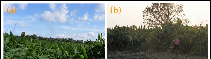
Sustainability 2019, 11, x FOR PEER REVIEW 4 of 21
2. Materials and Methods
2.1. Study Sites
Sustainability 2019, 11, 1978 4 of 18
This study covered eight municipalities of the alluvial plain of Tabasco, at elevations of −2 m to
15 m a.s.l. that are prone to cyclical flooding: Cárdenas, Huimanguillo, Comalcalco, Cunduacán, Jalpa
Jalpa de Méndez,
de Méndez, Nacajuca,
Nacajuca, Centla,Centla, and(Figure
and Jonuta Jonuta 2).(Figure
Tabasco2). isTabasco
located inis the
located
basininofthe
the basin of the
Papaloapan,
Papaloapan, Grijalva-Mezcalapa, and Usumacinta Rivers, in the south
Grijalva-Mezcalapa, and Usumacinta Rivers, in the south of the Gulf of Mexico [26]. They formof the Gulf of Mexico [26].a
They
complexformnet
a complex
of deltaicnet of deltaic
channels channels interconnected
interconnected with lakes, with
seasonallakes, seasonaland
wetlands wetlands
marshes, andwhich
marshes,
are
which are interconnected from September to February. Moreover, 96% of
interconnected from September to February. Moreover, 96% of the territory of Tabasco is on thethe territory of Tabasco is
on the coastal alluvial plains of the Gulf of Mexico [29]. The climate is warm–humid
coastal alluvial plains of the Gulf of Mexico [29]. The climate is warm–humid [30], with high [30], with high
precipitation
precipitation during
during summer
summer months,
months, andand anan annual
annual mean
mean rainfall
rainfall of
of1500–2980
1500–2980mm. mm. Annual
Annual mean
mean
temperature during the dry season (March to June) is 25–30 ◦ C. Before the middle of the 20th century,
temperature during the dry season (March to June) is 25–30 °C. Before the middle of the 20th century,
the
the area
area was about 50%
was about 50% covered
covered by bypermanent
permanentand andsemi-permanent
semi-permanentwetlandswetlands [26,28,29]
[26,28,29] andand most
most of
of the remaining area was covered by tropical rainforests. Currently, only relics
the remaining area was covered by tropical rainforests. Currently, only relics of these ecosystems of these ecosystems
exist
exist because
because of of anthropic
anthropic disturbances,
disturbances, suchsuch asas expansion
expansion of of the
the agricultural
agricultural andand livestock
livestock frontier
frontier
and
and the
the construction
construction of of dams
dams [28,29].
[28,29]. Other
Other relevant
relevant vegetation
vegetation types
types are
are flooded
flooded rain
rain forest,
forest, savanna
savanna
and
and mangrove
mangrove forest
forest [29,31].
[29,31]. The
The soils
soils in
in this
this area
area are
are vertisol,
vertisol, gleysol,
gleysol, cambisol,
cambisol, arcisol,
arcisol, luvisol,
luvisol, and
and
fluvisol [32].
fluvisol [32].
Figure 2.
Figure 2. Location
Location of of the
the state
state of
of Tabasco:
Tabasco: (a)
(a) Ombrogram
Ombrogram of of the
the study
study area,
area, (b)
(b) the
the municipalities
municipalities
studied: 1.
studied: 1. Huimanguillo,
Huimanguillo, 2. 2. Cárdenas,
Cárdenas, 3.
3. Comalcalco,
Comalcalco, 4.
4. Cunduacán,
Cunduacán, 5. 5. Jalpa de Méndez,
Méndez, 6. 6. Nacajuca,
7. Centla
7. Centlaand
and8. 8. Jonuta;
Jonuta; (c) Mexico
(c) the the Mexico Valley
Valley and
and the the and
Balsas Balsas and Coatzacoalcos
Coatzacoalcos Basins areBasins are also
also indicated.
indicated.
2.2. Locating the Localities Where Marceño is Currently Practiced and the Potential Area for Its Implementation
in Tabasco
2.2. Locating the Localities Where Marceño is Currently Practiced and the Potential Area for Its
Implementation
We reviewed in Tabasco
the literature about the marceño system [21,27,28,33,34], as well as the data from
the census of the Department of Agricultural Development of the municipality of Comalcalco and
We reviewed the literature about the marceño system [21,27,28,33,34], as well as the data from
all areas reported that use the marceño agroecosystem in the flood-prone areas of Tabasco (Figure 2).
the census of the Department of Agricultural Development of the municipality of Comalcalco and all
To determine the localities that currently practice the marceño system, we undertook fieldtrips to
areas reported that use the marceño agroecosystem in the flood-prone areas of Tabasco (Figure 2). To
identify the plots practising it and characterized the environment around the plots, including aquatic
determine the localities that currently practice the marceño system, we undertook fieldtrips to identify
vegetation types, known locally as popales and tulares (vegetation dominated by Thalia geniculata L.
the plots practising it and characterized the environment around the plots, including aquatic
and Typha domingensis Pers, respectively) [21]. Additionally, we verified the practice of the marceño
vegetation types, known locally as popales and tulares (vegetation dominated by Thalia geniculata L.
system in 80 plots within eight municipalities (Figure 2). These plots were georeferenced with a
Global Positioning System (GPS, Garmin e-trex 30, Kansas, USA). The presence of the marceño system
was confirmed by the smallholders of the plots, who were also asked about the characteristics of the
agroecosystem, particularly the flooding regime of the system.
Sustainability 2019, 11, 1978                                                                                               5 of 18

2.3. Modelling the Potential Distribution of Plant Species Associated with the Agroecosystem Using MaxEnt
      A model of the potential distribution of plant species associated with the marceño agroecosystem
for the coastal plain of Tabasco was built as follows: (1) We included the plant communities associated
with the agroecosystem located and georeferenced in the field and the historical occurrence of the 16
most frequent aquatic perennial herbs and tree species, both related to the agroecosystem and to the
flood-prone areas of the alluvial plain of Tabasco [21] (Table 1); we also included the plant records
for the Pacific and the Gulf coast of these species (a total of 3124 records, derived from the Global
Biodiversity Information Facility website [35]). (2) We obtained 19 bio-environmental variables (Table 2)
from the Bioclimas Neotropicales website [36] updated for Mexico, which compiles monthly climatic
layers for the interval 1910–2009 (Table 2). We elaborated the model using the MaxEnt (Maximum
Entropy Species Distributions Modelling, Version 3.33k [37]) algorithm that uses the function of
minimum entropy to calculate distribution probabilities [38–40]. In this study, we only included the
probabilities calculated for the state of Tabasco.

      Table 1. List of species, family and number of occurrences used for the distribution modelling of the
      marceño agroecosystem.

               Species                                     Common Name            Family              Occurrences
               Cladium jamaicense Crantz                   Cerillo, sibal         Cyperaceae          236
               Cyperus articulatus L.                      Chintul                Cyperaceae          377
               Echinochloa crus-pavonis (Kunth) Schult.    Camalote de agua       Poaceae             65
               Eleocharis cellulosa Torr.                  Junquillo              Cyperaceae          47
               Erythrina fusca Lour.                       Colorin                Fabaceae            10
               Haematoxylum campechianum L.                Tinto                  Fabaceae            485
               Hibiscus striatus                           Malva                  Malvaceae           10
               Jacquinia aurantiaca W.T. Aiton             Jaboncillo             Primulaceae         207
               Pachira aquatica Aubl.                      Zapote de agua         Malvaceae           431
               Panicum hirsutum Sw.                        Pelillo                Poaceae             35
               Phragmites australis (Cav.) Trin.           Carrizo                Poaceae             10
               Sagittaria lancifolia L.                    Cola de pato           Alismataceae        231
               Salix humboldtiana Willd.                   Sauce                  Salicaceae          209
               Scleria macrophylla J. Presl & C. Presl     Navajuela              Cyperaceae          30
               Thalia geniculata L.                        Popal, hojilla         Marantaceae         406
               Typha domingensis Pers.                     Tule, nea              Typhaceae           335
                                                                                  Total               3124

      Table 2. Climatic variables used in the modelling of the potential distribution of thirteen wild species
      related to the marceño agroecosystem based on Bioclimas Neotropicales [36].

 Bioclimate Variable                                  Units Bioclimate Variable                                             Units
 B1 = Annual mean temperature                         ◦C       B10 = Mean temperature of warmest quarter                    ◦C
 B2 = Mean diurnal range (mean of monthly (max        ◦C       B11 = Mean temperature of coldest quarter                    ◦C
 temp—min temp))
 B3 = Isothermality (B2/B7) × 100                     ◦C       B12 = Annual precipitation                                   mm
 B4 = Temperature seasonality (standard               ◦C       B13 = Precipitation of wettest month                         mm
 deviation ×100)
 B5 = Max temperature of warmest month                ◦C       B14 = Precipitation of driest month                          mm
 B6 = Min temperature of coldest month                ◦C       B15 = Precipitation seasonality (coefficient of variation)   mm
 B7 = Temperature annual range (B5-B6)                ◦C       B16 = Precipitation of wettest quarter                       mm
 B8 = Mean temperature of wettest quarter             ◦C       B17 = Precipitation of driest quarter                        mm
 B9 = Mean temperature of driest quarter              ◦C       B18 = Precipitation of warmest quarter                       mm
                                                               B19 = Precipitation of coldest quarter                       mm

2.4. Generating the Terrain Elevation Model
     To generate the digital model of terrain elevation (−2.96 to 1146.25 m) for the state of Tabasco,
we processed LiDAR images with ArcMap 10.2.1 Arc Gis Esri (1360 images in GRID format, E-15
region [41]). The horizontal resolution was 5 m. These models did not include infrastructure and
vegetation in order to identify the localities that used the marceño agroecosystem. We used this model
Sustainability 2019, 11, 1978                                                                                                6 of 18

of terrain elevation to locate low elevation areas (0–7 m) in order to determine the areas subject to
flooding and with potential to implement the marceño system.

2.5. Modelling the Potential Areas for the Marceño Agroecosystem
     For this estimation, we included areas with both agriculture and pastures that naturally have
floods and are therefore susceptible to productive reconversion to marceño.
     We used the SIG ArcMap software to geoprocess the following information: (1) To determine the
flood-prone areas with elevations from 0 to 7 m, we used LiDAR images of terrain elevation [41]; (2) to
identify flood-prone areas with agricultural and cultivated grass pastures, and to discard preserved
areas with aquatic vegetation (marshes, mangroves, flooded rain forest, and permanently flooded
areas), rain forest areas, natural protected areas, urban areas, infrastructure, and drained areas with
elevations of 18–1146 m, we used the layers of soil—gleysol and vertisol (silty-clay with poor drainage
and high organic matter content)—and vegetation [32,42]; (3) we used the layer of highest probabilities
of distribution of plant communities associated with the marceño system (as generated in Section 2.3);
(4) we also added a layer with the location of the Maya Chontal population, with the data collected
from [43]; (5) we superimposed all five layers to determine the areas with potential to use the marceño
agroecosystem including the pasture areas with potential for reconversion to agriculture, the ethnic
origin of the population and their influence area (biocultural region [25]).

3. Results

Location of the Marceño Agroecosystem in the State of Tabasco
     We located the presence of the marceño system in the field in 203 localities in the eight
municipalities of Tabasco, particularly in Comalcalco, Nacajuca and Cunduacán (Table 3). According
to the elevation model of the terrain (LiDAR), these localities are at elevations of 1−7 m with high
precipitation (≥2980 mm). This high precipitation causes cyclic floods that maintain the seasonal
swamps and other areas used for extensive cattle raising (Figure 3, Table 3, Table 4, and Table A1).
     Sustainability 2019, 11, x FOR PEER REVIEW                                                                    7 of 21

          Figure
      Figure      3. Mapofofthe
              3. Map         the elevation
                                 elevationofofthethe
                                                  terrain (−2 to(−
                                                      terrain    1146.25 m, see Table
                                                                   2 to 1146.25       4) and
                                                                                 m, see      locations
                                                                                          Table        of the
                                                                                                  4) and      Tabascoof the
                                                                                                           locations
          localities,
      Tabasco         wherewhere
               localities,   the practice of the marceño
                                     the practice   of theagroecosystem    occurs nowadays
                                                            marceño agroecosystem             (■),nowadays
                                                                                         occurs    aquatic vegetation
                                                                                                               (), aquatic
          patches of popal (■) and tular (■), drain channels (−) with Plan Chontalpa (−) and Plan Balancan-
      vegetation patches of popal () and tular (), drain channels (−) with Plan Chontalpa (−) and Plan
          Tenosique (−), Villahermosa city (■).
      Balancan-Tenosique (−), Villahermosa city ().
           Table 3. Municipalities, number of localities (L), and elevation range (TER) where the marceño was
           located in Tabasco, Mexico. Total population (TP), indigenous population (IP), and percentage of
           indigenous population for each municipality (IP%).

                   Municipality             L       TER (m a.s.l.)    TP               IP           IP%
                   Cárdenas                 25      0−14              22,486           170          0.8
                   Centla                   22      1−11              22,965           5851         25.5
                   Comalcalco               43      2−11              72,899           390          0.5
                   Cunduacán                31      3−10              29,823           154          0.5
                   Huimanguillo             12      6−10              9,670            32           0.3
                   Jalpa de Méndez          23      3−10              34,823           1133         3.3
                   Jonuta                   12      0−11              10,337           640          6.2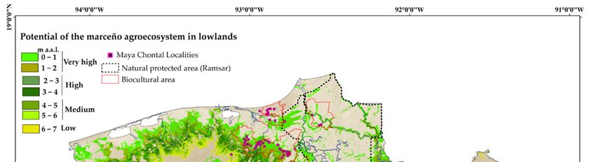
Sustainability 2019, 11, 1978                                                                            7 of 18

      Table 3. Municipalities, number of localities (L), and elevation range (TER) where the marceño was
      located in Tabasco, Mexico. Total population (TP), indigenous population (IP), and percentage of
      indigenous population for each municipality (IP%).

                   Municipality           L           TER (m a.s.l.)     TP          IP        IP%
                   Cárdenas               25          0−14               22,486      170       0.8
                   Centla                 22          1−11               22,965      5851      25.5
                   Comalcalco             43          2−11               72,899      390       0.5
                   Cunduacán              31          3−10               29,823      154       0.5
                   Huimanguillo           12          6−10               9670        32        0.3
                   Jalpa de Méndez        23          3−10               34,823      1133      3.3
                   Jonuta                 12          0−11               10,337      640       6.2
                   Nacajuca               35          2−14               43,631      20,938    48
                   Total:                 203                            264,381     47,119    18

                         Table 4. Elevation range of the terrain in the state of Tabasco, Mexico.

                Elevation Range (m a.s.l.)         Areas (km2 )        % Areas of the State of Tabasco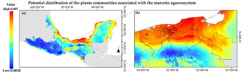
Sustainability 2019, 11, 1978                                                                                                                                                                 8 of 18

      Table 5. Livestock and agricultural areas susceptible to cyclical flooding that have potential (very high, high and medium) to be converted into the marceño
      agroecosystem. Areas are shown with flooding potential and percentage, representing each municipality’s area.

                                                                                                              Area for Reconversion
                                                       Cyclic Flooding Potential                                                           Area with Wetland Vegetation Conserved (1)
                                                                                                                   to Marceño
        Elevation Terrain
                                         0−2                       2−4                        4−6
          Range m a.s.l.
                                    Very High                      High                     Medium               Cultivated Grass                   Popal                      Tular
          Municipality
                                km2             %          km2            %           km2            %           km2            %           km2             %          km2             %
           Comalcalco           158.57         20.7       154.66          20.2       129.93           17        310.86         40.6         49.16            6.4       93.11           12.2
            Cárdenas            323.23         15.8        83.59           4.1       133.85           6.5      550.01          26.9         66.27            3.2      161.72            7.9
           Cunduacán             0.08          0.01        4.60           0.77       40.63           6.8        85.93          14.4         5.91            1.0       41.97            7.0
            Nacajuca            105.78         19.8        62.93          11.8        51.72           9.7      242.80          45.5        106.93           20.0      126.38           23.7
        Jalpa de Mendéz          63.39         17.2        67.55          18.3        89.69          24.3       119.19         32.3         43.46           11.8       36.21           9.8
             Jonuta             135.35          8.2       211.33          12.9       166.81          10.2       513.49         31.3        226.97           13.8      343.33           20.9
             Centla             232.26          8.6         6.12          0.23         0.15          0.01      237.40           8.8        163.00            6.1     1394.78           51.9
             Centro             215.32         13.6       150.78           8.8       156.48           9.3      1044.78          61          33.99            2.0      303.33           17.7
         Huimanguillo           280.72          7.6       157.96           4.3       145.69           3.9      583.22          15.7        147.02            4.0      151.62            4.1
           Macuspana            194.26          8.0       190.13           8.0        90.12           3.7      1522.72         62.8         34.18            1.4      550.73           22.7
             Paraíso             63.00          3.0        12.99          0.64         2.30          0.11        53.01         13.0          −               −        30.67            7.5
      Notes: (1) The areas originally covered by popal, were disturbed by clearance for agriculture, fires for turtle hunting, and cattle raising. Vegetation was substituted by aggressively
      introduced forages and weeds that cover vast areas with cyclic flooding. Additionally, the drainage of wetlands has dropped the phreatic level.
Sustainability 2019, 11, 1978 9 of 18
Sustainability 2019, 11, x FOR PEER REVIEW 10 of 21
Sustainability 2019, 11, x FOR PEER REVIEW 10 of 21
Figure
Figure 4.4. Potential
Potential distribution
distribution of of 16
16 aquatic
aquatic plant
plant species
species reported
reported toto be
be associated
associated with the marceño
with the marceño
agroecosystem. The model was
agroecosystem. The model was built for both built for both the Pacific and Gulf Mexico Costal regions to give
give
Figure 4. Potential distribution of 16 aquatic plant species reported to be associated with the marceño
robustness
robustness to
to the
the model
model (Table
(Table 1).
1). The
The colours
colours represent
represent the
the potential
potential probability
probability of
of (a)
(a) the
the potential
potential
agroecosystem. The model was built for both the Pacific and Gulf Mexico Costal regions to give
distribution
distribution model for all
robustness to the modelall
the
the areas
(Table areas included
1). Theincluded
in
in the
the MaxEnt
colours represent MaxEnt analysis;
analysis;
the potential
(b)
(b) the
probability the potential
potential
of (a)
distribution
distribution
the potential
model
model of
of distribution
distribution of
of the aquatic plant communities found in Tabasco
Tabasco where
where currently
currently
distribution model for all the areas included in the MaxEnt analysis; (b) the potential distribution the marceño
the marceño
agroecosystem
agroecosystem is practiced
is practiced
model of distribution ( •
of the (●).). Current
aquaticCurrent Maya Chontal
Maya Chontal
plant communities populations
populations
found (N
in Tabasco(▲).).
where currently the marceño
agroecosystem is practiced (●). Current Maya Chontal populations (▲).
The 2
The geospatial
geospatial analysis
analysis showed
showed that that approximately
approximately 1693.71
1693.71 km km2 hashas aa very
very high
high potential
potential for
for
marceño
marceño(0–2
(0–2mma.s.l.).
The a.s.l.).Considering
geospatial analysis showed
Considering the
thepredictable
that periodicity
approximately
predictable of seasonal
1693.71
periodicity km 2 has
of seasonalaflooding,
very highonlyonly
flooding, about
potential for
about km2
1259 1259
hasmarceño
higha(0–2 m a.s.l.). Considering the predictable periodicity of
onseasonal flooding,inundation.
only about 1259
km2ahas potential (2–4
high potential m(2–4
a.s.l.)mbecause of its dependence
a.s.l.) because the severity
of its dependence on theofseverity Moreover,
of inundation.
km 2 has a high potential 2(2–4 m a.s.l.) because of its dependence on the
approximately 1140.1 km has a moderate potential and 471.3 km 2 severity
has a low ofpotential
inundation.
(4–6 and
Moreover, approximately 1140.1 km2 has a moderate potential and 471.3
2 km has a low potential
2 (4–
Moreover, approximately 1140.1 km has a moderate potential and 471.3 km2 has a low potential (4–
6–7 m 6–7
6 and a.s.l.,
m respectively)
a.s.l., because
respectively) this area
because this isarea
susceptible
is to flooding
susceptible to in years
flooding in with atypically
years with high
atypically
6 and 6–7 m a.s.l., respectively) because this area is susceptible to flooding in years with atypically
rainfalls.
high The estimated
rainfalls. potential of the marceño agroecosystem formed approximately 18.4%
18.4% of
high rainfalls.The
Theestimated potential
estimated potential ofofthe
the marceño
marceño agroecosystem
agroecosystem formedformed approximately
approximately 18.4% of of
Tabasco’s
Tabasco’s area
area (Figure
(Figure 5,
5,Table
Table
Tabasco’s area (Figure 5, Table 6).
6).
6).
Figure
Figure 5. 5. Agricultural and
Agricultural and livestock
livestockareas
areasinin thethe
Tabasco state
Tabasco withwith
state potential to be cultivated
potential with thewith the
to be cultivated
marceño
marceño agroecosystem. Probabilities
agroecosystem. Probabilities ofofcyclic
cyclic annual flooding
annual occurrence
flooding (areas(areas
occurrence and elevations in the in the
and elevations
range5.−2Agricultural
Figure to 7 m) are indicated
and (see Table
livestock areas6). in the Tabasco state with potential to be cultivated with the
range −2 to 7 m) are indicated (see Table 6).
marceño agroecosystem. Probabilities of cyclic annual flooding occurrence (areas and elevations in the
range −2 to 7 m) are indicated (see Table 6).
Sustainability 2019, 11, 1978                                                                                  10 of 18

               Table 6. Potential area for the marceño agroecosystem in the lowlands of Tabasco, Mexico.

   Potential      Elevation Range (m a.s.l.)   Potential Area (km2 )   Total (km2 )   % Area of the State of Tabasco
                                 0–1                  911.9
  Very high                     1–1.5                 420.7              1693.7                    6.85
                                1.5–2                 361.1
                                2–2.5                 330.3
                                2.5–3                 316.2
     High                                                                1259.0                    5.09
                                3–3.5                 307.3
                                3.5–4                 305.2
                                4–5                   574.8
   Medium                                                                 140.1                    4.61
                                5–6                   565.4
     Low                        6–7                   471.3               471.3                    1.91
                                                      Total:             4564.2                   18.46

4. Discussion
      During the fieldwork, we corroborated the presence of the marceño agroecosystem in Tabasco’s
rural communities, many of which have been inhabited by the Maya Chontal since pre-Hispanic times
(Figures 3–5; Table 3). These localities are in the range of 1–14 m above sea level and are susceptible to
seasonal flooding. Based on the reports of the Food Information Services of Tabasco [44], regarding
the area of planted maize during the spring–summer cycle, it can be inferred from our model that,
currently, the marceño system cover less than 463.52 km2 , which represents approximately 10% of
the potential area (Figure 5, Table 3). The presence of marceño had been reported in 183 localities
previously [33], whereas we found it in 203 localities. However, there might be many other locations
in rural areas that use the marceño agroecosystem, as it is a current practice in rural areas used by both
Maya Chontal and Mestizo people. It is also possible that a greater number of localities practice the
marceño system in the lowlands and nearby towns of Tabasco, on the banks of the Usumacinta River in
the state of Campeche (locality of Palizada), given the cultural similarities of the region.
      The model of potential distribution of the plant communities associated with marceño allowed
an estimation of the areas where the ecosystem is conducive to the implementation of the marceño
agroecosystem as a rural development strategy in Tabasco. Marceño is cultivated predominantly to feed
the Maya Chontal population. A total of 59% of this area is currently occupied by primary activities
such as subsistence agriculture, mainly in the municipality of Nacajuca [43]. The management of the
popal by the marceño agroecosystem is fundamental to the subsistence of this population. In Tabasco,
there are 79694 Maya Chontal people (3.6% of the population) [43], 62% of which live within the “La
Chontalpa” biocultural region [25]. This indigenous territory covers about 794.06 km2 (3.2% of the
area of the state), mainly in the municipalities of Nacajuca and Centla. In this study, we found that
important areas of wetland vegetation were considered as popal. Our results showed that, in this area,
269.93 km2 (11.4%) and 1521.2 km2 (43%) are covered with popal and tular, respectively (Figure 3,
Table 4).
      It is relevant that approximately 7% of the Mayan Chontal territory is located within the Natural
Protected Area of the “Reserva de la Biosfera Pantanos de Centla” (3027.06 km2 ) [45], one of the priority
regions for the conservation of biodiversity and agrobiodiversity. This area has been protected by
the Government of Mexico and the Ramsar Convention [46]. For that reason, we only used the areas
actually used for cattle, and the marceño agroecosystem (using landraces, mainly mején), to calculate the
potential areas for marceño. This conservation area protects against the construction of infrastructure
for forced drainage that completely modifies the hydrology and the ecological cycles of wetlands [9,10].
In the marceño agroecosystem and other examples of extensive agricultural carried out in the wetlands,
the combination of food production and ecosystem services in this area might contribute to the high
resilience of both the wetlands and marceño system [21,24,27,28], which maintains other ecosystem
services such as improving water quality, stopping floods, and maintaining biodiversity [7] and
agrobiodiversity [9].
Sustainability 2019, 11, 1978 11 of 18
Currently, there are examples of reactivation of pre-Hispanic agricultural systems in wetlands,
such as the waru waru or suka kollus system in Lake Titicaca [47] and the implementation of the
“chinampas chontales” in Nacajuca, Tabasco, which are similar to the chinampas system in the Valley
of Mexico [48]. Similarly, the calculated potential areas for the marceño agroecosystem represent a
viable alternative to produce food for ecological restoration programs of the lowlands of Tabasco and
other tropical regions where the traditional cultivation of corn is the basis of the smallholders’ diet.
Additionally, the marceño agroecosystem is recognized by the smallholders for its high soil fertility
and good yield of corn crops in flooded areas (actually ∼4.3 ton ha−1 of grain, including native maize
varieties such as mején).
The characteristic abundance of popal in the hydrophilic vegetation of the landscape and culture
of the Tabasco lowlands has been altered by a lack of interest and understanding of its cultural
and ecological relevance, as well as a lack of knowledge about its management and productive
potential. The marceño agroecosystem is part of the local biocultural identity and its maintenance and
enhancement may also contribute to the conservation of the Tabasco wetlands and biocultural heritage.
Abandoning the marceño agroecosystem would represent the loss of a unique agrobiodiversity and a
biocultural landscape that represents the important identity of the Tabasco lowlands. On the other
hand, the marceño might contribute to the tropical subsistence agriculture. This is relevant because the
FAO reports that, in Central America, household traditional agriculture farmers produce about 50% of
the agricultural production of the region and more than 70% of the foods.
The findings of this study have an important implication for other wetland areas in Mexico and
elsewhere in the world, such as the Rhine [49], Danube, and Mississippi [50] River basins. It could
also be adopted as a model in agricultural development plans in other tropical regions with cyclical
floods and food poverty. This would also allow in situ conservation of agrobiodiversity of varieties
of crops that have adapted to high humidity conditions, such as maize mején, which represents a
genetic reservoir for research on new varieties that are tolerant to waterlogging. Marceño represents an
opportunity for agroecological studies that allows communities settled in areas susceptible to cyclical
floods (61.6% of the state of Tabasco) to develop. This might allow sustainable development, which
could be accompanied by ecological restoration programs and the conservation of the biocultural
landscape of the Tabasco wetlands.
5. Conclusions
Marceño is relevant for smallholders who produce food for self-consumption in one of the poorest
and most vulnerable regions of Mexico. The adoption of practices of sustainable management of
natural resources and the retention of traditional agricultural systems by smallholders has been
proposed by the FAO as part of a strategy to adapt to climate change, eradicate global poverty and end
hunger. The Intergovernmental Panel on Climate Change estimates that agronomic adaptation could
improve yields by 15 to 18% [49]. This demonstrates the significance of household agriculture, such as
marceño, for the food sovereignty of the smallholder communities [50,51]. In Tabasco, the maize crop
occurs in the rainy season, but the marceño system occurs in the dry season, allowing an additional
staggered agricultural cycle during the recession of the flood. This study improves the understanding
of the current context of the marceño agroecosystem in the lowlands of Tabasco.
Author Contributions: H.P.-V., A.O.-S., A.C. and R.L.-C. identified the research questions, analysed the data, and
wrote the paper.
Funding: This work was supported by the Universidad Nacional Autónoma de México (project DGAPA-PAPIIT
IN-205715), the Consejo Nacional de Ciencia y Tecnología (project SEP-CONACyT-221015, the Doctor’s scholarship
334495 to Humberto Peraza Villarreal) and the Programa de Posgrado en Ciencias Biológicas, UNAM.
Acknowledgments: We dedicate this research to the relevant agroecologists, Arturo Gómez-Pompa and Stephen
Gliessman. We thank María de Jesús Ordoñez, María Esther Sánchez Coronado, José Gerardo Rodríguez Tapia,
Alejandro René González Ponce, José Miguel Baltazar Gálvez, Luz Palestina Llamas Guzmán and Luis Vidal
Pedrero López for technical support.Sustainability 2019, 11, 1978 12 of 18
Conflicts of Interest: The authors declare no conflict of interest.
Appendix A
Table A1. Localities indicated in the Figure 3.
Municipality Id Number and Locality Showed in Figure 3
1.Arroyo Hondo 1ra. Sección (Santa Teresa A)
2.Arroyo Hondo Abejonal
3.Azucena 2da. Sección
4.Azucena 3ra. Sección (El Triunfo)
5.Azucena 4ta. Sección (Torno Alegre)
6.Buenavista 1ra. Sección
7.Buenavista 2da. Sección
8.Cárdenas
9.El Capricho
10.El Golpe
11.El Golpe 2da. Sección (Los Patos)
12.El Porvenir
Cárdenas 13.Ignacio Gutiérrez Gómez (San Felipe)
14.Islas Encantadas (El Zapote y Reyes Heroles)
15.La Trinidad
16.Las Coloradas 2da. Sección (Ampliación las Aldeas)
17.Naranjeño 2da. Sección A
18.Nueva Esperanza
19.Paylebot
20.Poblado C-28 Coronel Gregorio Méndez Magaña Uno
21.Poza Redonda 1ra. Sección
22.Poza Redonda 4ta. Sección (Rincón Brujo)
23.Río Seco 1ra. Sección
24.Santana 2da. Sección A
25.Zapotal 1ra. Sección
26. Buena Vista
27.Chichicastle 2da. Sección
28. Chichicastle 3ra. Sección
29.Cuauhtémoc
30.El Carmen 2da. Sección
31.El Guatope
32.El Limón (De Vicente Guerrero)
33.El Naranjal
34.El Porvenir
35.Gregorio Méndez Magaña
36.Hablan los Hechos (Santa Rosa)
Centla
37.Leandro Rovirosa Wade 1ra. Sección
38.Leandro Rovirosa Wade 2da. Sección
39.Nueva Esperanza de Quintín Aráuz
40.Potrerillo
41.Quintín Aráuz
42.Ribera Alta 1ra. Sección
43.Ribera Alta 3ra. Sección
44.San José de Simón Sarlat (El Coco)
45.Simón Sarlat
46.Tres Brazos
47.Vicente GuerreroSustainability 2019, 11, 1978 13 of 18
Table A1. Cont.
Municipality Id Number and Locality Showed in Figure 3
48.Arena 1ra. Sección
49.Arena 3ra. Sección
50.Arena 4ta. Sección
51.Arroyo Hondo 3ra . Sección
52.Belisario Domínguez
53.Carlos Greene
54.Carlos Greene 1ra. Sección Tres (Colonia el Limón)
55.Carlos Greene 4ta. Sección
56.Chichicapa
57.Cupilco
58.Cuxcuxapa
59.Francisco I. Madero 1ra. Sección
60. Francisco I. Madero 2da. Sección
61.Francisco Trujillo Gurría
62.Gregorio Méndez 1ra. Sección
63.Gregorio Méndez 2da. Sección
64.Gregorio Méndez 3ra. Sección
65.Guatemalán
66.Guayo 2da. Sección
67.Independencia 1ra. Sección
Comalcalco 68.Independencia 2da. Sección
69.Independencia 3ra. Sección
70.José María Pino Suárez 1ra. Sección
71.Lagartera
73.León Zárate 1ra. Sección
74. León Zárate 2da. Sección
75.Norte 1ra. Sección (San Julián)
76.Novillero 4ta. Sección
77.Occidente 1ra. Sección
78.Occidente 2da. Sección
79.Occidente 3ra . Sección
80.Oriente 3ra. Sección
81.Oriente 6ta. Sección (Los Mulatos)
82.Paso de Cupilco
83.San Fernando (Pueblo Nuevo)
84.Sargento López 1ra. Sección
85.Sargento López 2da. Sección (El Chuzo)
86.Sargento López 3ra . Sección (San Jorge)
87.Sargento López 4ta. Sección
88.Tecolutilla
89.Tránsito Tular
90.Zapotal 2da. Sección
91.Alianza para la Producción
92.Anta y Cúlico (Santa Rita)
93.Buenaventura
94.Buenos Aires
95.Ceiba 1ra. Sección (Jahuactal)
96.Cúlico 1ra. Sección
97.Cumuapa 1ra. Sección
Cunduacán
98.Dos Ceibas
99.El Palmar
100.El Tunal
101.Felipe Galván
102.General Francisco J. Mújica
103.Gregorio Méndez
104.Huimango 1ra. SecciónSustainability 2019, 11, 1978 14 of 18
Table A1. Cont.
Municipality Id Number and Locality Showed in Figure 3
105.La Chonita
106.La Piedra 2da. Sección
107.Laguna de Cucuyulapa
108.Libertad 2da. Sección
109.Los Cerros
110.Mantilla
111.Marín
112.Miahuatlán (San Gregorio)
113.Miahuatlán (San Nicolás)
Cunduacán
114.Miahuatlán 1ra. Sección
115.Monterrey
116.Morelos Piedra 3ra. Sección
117.Once de Febrero (Campo Bellota)
118.Pechucalco 2da. Sección (Las Cruces)
119.Rancho Nuevo
120.San Pedro Cumuapa
121.Yoloxóchitl 3ra. Sección
122.Benito Juárez 1ra. Sección
123.Benito Juárez 2da. Sección (Monte Alegre)
124.Blasillo 1ra. Sección (Nicolás Bravo)
125.Blasillo 4ta. Sección
126.Huapacal 2da. Sección
Huimanguillo 127.Paso de la Mina 1ra. Sección
128.Pejelagartero 1ra. Sección (Gpe. Victoria)
129.Pejelagartero 2da. Sección
130.Pejelagartero 2da. Sección (Nueva Reforma)
131.Tres Bocas 1ra. Sección
132.Tres Bocas 2da. Sección (El Zapotal)
133.Zanapa 1ra. Sección
134.Ayapa
135.Benito Juárez 2da. Sección
136.Boquiapa
137.Chacalapa 1ra. Sección
138.Chacalapa 2da. Sección (San Manuel)
139.Hermenegildo Galeana 1ra. Sección
140.Hermenegildo Galeana 2da. Sección
141.Huapacal 1ra. Sección
142.Huapacal 2da. Sección (Punta Brava)
143.Iquinuapa
144.La Ceiba
Jalpa de Méndez 145.La Cruz
146.Mecoacán
147.Mecoacán 2da. Sección (San Lorenzo)
148.Nabor Cornelio Álvarez
149.Nicolás Bravo
150.Reforma 1ra. Sección
151.Reforma 3ra. Sección (El Guano)
152.San Nicolás
153.Santuario 2da. Sección
154.Soyataco
155.Tierra Adentro 2da. Sección
156.Vicente Guerrero 1ra. Sección
157.Vicente Guerrero 2da. SecciónSustainability 2019, 11, 1978 15 of 18
Table A1. Cont.
Municipality Id Number and Locality Showed in Figure 3
158.El Cocal
159.Francisco J. Mújica
160.Jonuta
161.José María Pino Suárez (San Pedro)
162.La Bendición (La Tijera)
Jonuta 163.La Candelaria
164.La Concordia
165.Prudencio López Arias
166.Ribera Baja 2da. Sección (Gran Poder)
167.Torno de la Bola
168.Monte Grande
169.Arroyo
170.Cantemoc 1ra. Sección
171.Cantemoc 2da. Sección
172.Chicozapote
173.Corriente 1ra. Sección
174.Corriente 2da . Sección
175.El Cometa
176.El Zapote
177.Guatacalca
178.La Loma
179.Libertad
180.Lomitas
181.San Isidro 1ra. Sección
182.Taxco
183.Tecoluta 1ra . Sección
184.Belén
185.Chicozapote
Nacajuca 186.El Chiflón
187.El Pastal
188.El Sitio
189.El Tigre
190.Guatacalca (Guatacalca 1ra . Sección)
191.Guaytalpa
192.Isla Guadalupe
193.La Cruz de Olcuatitán
194.Mazateupa
195.Olcuatitán
196.Oxiacaque
197.Saloya 1ra. Sección
198.San Isidro 2da . Sección
199.San José Pajonal
200.San Simón
201.Tapotzingo
202.Tecoluta 2da . Sección
203.Tucta
References
1. Bruinsma, J. World Agriculture: Towards 2015/2030, An FAO Perspective; Earthscan and FAO: London, UK;
Rome, Italy, 2003; p. 432.
2. FAO. Boletín de Agricultura Familiar Para América Latina y el Caribe. Alimentar al Mundo sin Comprometer el
Future; FAO: Rome, Italy, 2018; p. 30.
3. Zedler, J.B.; Kercher, S. Causes and consequences of invasive plants in wetlands: Opportunities, opportunists,
and outcomes. CRC Crit. Rev. Plant Sci. 2004, 23, 431–452. [CrossRef]Sustainability 2019, 11, 1978 16 of 18
4. INEGI. XII Censo General de Población y Vivienda 2000–2010. Available online: https://www.inegi.org.mx
(accessed on 20 March 2015).
5. Cadena, S.; Suárez, S. Los Chontales Ante Una Nueva Expectativa de Cambio: El Petróleo; Instituto Nacional
Indigenista: Mexico City, Mexico, 1988; Volume 306, p. 213.
6. Costanza, R.; D’Arge, R.; de Groot, R.; Farber, S.; Grasso, M.; Hannon, B.; Limburg, K.; Naeem, S.; O’neill, R.V.;
Paruelo, J.; et al. The value of the world’s ecosystem services and natural capital. Nature 1997, 387, 253.
[CrossRef]
7. Finlayson, M.; Cruz, R.D.; Davidson, N.; Alder, J.; Cork, S.; de Groot, R.S.; Lévêque, C.; Milton, G.R.;
Peterson, G.; Pritchard, D.; et al. Millennium Ecosystem Assessment. Ecosystems and Human Well-Being:
Synthesis; World Health: Washington, DC, USA, 2005; p. 137.
8. Zedler, J.B.; Kercher, S. Wetland Resources: Status, Trends, Ecosystem Services, and Restorability. Annu. Rev.
Environ. Resour. 2005, 30, 39–74. [CrossRef]
9. Verhoeven, J.T.A.; Setter, T.L. Agricultural use of wetlands: Opportunities and limitations. Ann. Bot. 2010,
105, 155–163. [CrossRef]
10. Zedler, J.B. Wetlands at Your Service: Reducing Impacts of Agriculture at the Watershed Scale. Front. Ecol.
Environ. 2003, 1, 65–72. [CrossRef]
11. Everard, M. Food from Wetlands. In The Wetland Book; Finlayson, C.M., Everard, M., Kenneth, I., McInnes, R.J.,
Middleton, B.A., van Dam, A.A., Davidson, N.C., Eds.; Springer Science + Buisness: Berlin/Heidelberg,
Germany, 2016.
12. Saarnak, N.L. Flood recession agriculture in the Senegal River Valley. Geografisk Tidsskrift 2003, 103, 99–113.
[CrossRef]
13. Vallod, D.; Flandin, M.; Chavallard, P.; Fourrié, L.; Sarrazin, B. Etude des facteurs de transfert des produits
phytosanitaires vers des étangs piscicoles en Dombes, zone humide continentale associant prairies et cultures.
Fourrages 2008, 193, 51–63.
14. Le Bourdiec, F. Le développment de la riziculture dans L’ Ouest Malgache. In Changements Sociaux dans
l’Ouest Malgache; Waast, R., Fauroux, E., Schlemmer, B., Le Bourdiec, F., Raison, J.-P., Dandoy, G., Eds.;
Collection Memoires 90; Orstom: Paris, France, 1980; pp. 133–152.
15. Moreno-Calles, A.I.; Toledo, V.M.; Casas, A. Los sistemas agroforestales tradicionales de México: Una
aproximación biocultural. Bot. Sci. 2013, 91, 375–398. [CrossRef]
16. González-Jácome, A.G. El manejo del agua y algunos elementos de la agricultura en Tlaxcala.
Perspect. Latinoam. 2013, 10, 69–82.
17. Rojas, T.R. Las chinampas del Valle de México. In Presente, Pasado y Futuro de las Chinampas; Centro de
Investigaciones y Estudios Superiores en Antropología Social: Mexico City, Mexico, 1995; p. 324.
18. Coe, M.; Diehl, R.A. In the Land of the Olmec; University of Texas Press: Austin, TX, USA, 1980; Volume 1.
19. Good, E.C. Traditional Gardening Techniques among Nahuatl Indians: ‘Huertos de Humedad’ in the Balsas
River Valley, Mexico. Anales de Antropología 2005, 39, 111–129.
20. Del Amo, S.; Rueda, R.A.L.; Delgado, M.C. The tecallis: A traditional cultivation system. In Global Perspectives
on Agroecology and Sustainable Agriculture; Proceedings of the Sixteenth International Scientific Conference of the
International Federation of Organic Movements (IFOAM); University of Santa Cruz: Santa Cruz, CA, USA, 1988.
21. Orozco-Segovia, A.; Gliessman, S. The marceño in flood-prone regions of Tabasco, Mexico. In Proceedings of
the XLIII International Congress of Americanists, Vancouver, BC, Canada, 11–17 August 1979.
22. Casas, A.; Vásquez, M.C.; Viveros, J.L.; Caballero, J. Plant management among Nahua and the Mixtec from
the Balsas River Basin: And ethnobotanical approach to the study of plant domestication. Hum. Ecol. 1996,
24, 455–478. [CrossRef]
23. Casas, A.; Otero-Arnaiz, A.; Pérez-Negrón, E.; Valiente-Banuet, A. In situ management and domestication of
plants in Mesoamerica. Ann. Bot. 2007, 100, 1101–1115. [CrossRef] [PubMed]
24. Toledo, V.M.; Barrera-Bassols, N. La Memoria Biocultural. La Importancia Agroecológica de las Sabidurías
Tradicionales, 1st ed.; Icaria, Ed.; Junta de Andalucia: Barcelona, Spain, 2008; Volume 3, p. 149.
25. Boege, S.E. El Patrimonio Biocultural de los Pueblos Indígenas de México. Hacia la Conservación In Situ de la
Biodiversidad y Agrodiversidad en los Territorios Indígenas, 2nd ed.; Instituto Nacional de Antropología e Historia,
Comisión Nacional Para el Desarrollo de los Pueblos Indígenas: Mexico City, Mexico, 2008; p. 344.
26. West, R.C.; Psuty, N.P.; Thom, B.G. Las Tierras Bajas de Tabasco en el Sureste de México; Instituto de Cultura de
Tabasco: Villahermosa, Mexico, 1985; p. 416.Sustainability 2019, 11, 1978 17 of 18
27. Orozco-Segovia, A. El marceño en las zonas inundables de Tabasco. In Agricultura y Sociedad en México:
Diversidad, Enfoques, Estudios de Caso; González-Jácome, A., Amo-Rodríguez, S., Eds.; Plaza y Valdez Editores:
Mexico City, Mexico, 1999; pp. 111–122.
28. Orozco-Segovia, A.; Vazquez-Yanes, C. One option for the use of marshes of Tabasco Mexico. In Proceedings
of the 7th Annual Conference on Wetlands Restoration and Creations, Tampa, FL, USA, 16–17 May 1980;
Cole, D., Ed.; Hillsborough Community College: Tampa, FL, USA, 1980.
29. Bueno, J.; Álvarez, F.; Santiago, S. Biodiversidad del Estado de Tabasco; Universidad Nacional Autónoma de
México: México, Mexico, 2005; p. 370.
30. García, E. Modificaciones al Sistema de Clasificación Climática de Köppen; Instituto de Geografía: Mexico City,
Mexico; Universidad Nacional Autónoma de México: Mexico City, Mexico, 1964; Volume 6, p. 98.
31. West, R.C. The natural vegetation of the Tabascan lowlands, Mexico. Revista Geográfica 1966, 64, 108–122.
32. INIFAP-CONABIO. Edafología Escala 1:250000-1:1000000. 1995. Available online: http://www.conabio.gob.
mx/informacion/gis/ (accessed on 20 March 2015).
33. Mariaca, M.R. Características tecnológicas del sistema marceño de cultivo de maíz en las tierras bajas de
Tabasco. Revista de Geografía Agrícola 1993, 18, 69–76.
34. Mariaca, M.R. El ciclo del marceño en las tierras bajas pantanosas de Tabasco: Producción tradicional de
maíz altamente productivo. Agrociencia 1996, 30, 279–286.
35. GBIF. The Global Biodiversity Information Facility. Available online: https://www.gbif.org/what-is-gbif
(accessed on 3 November 2016).
36. Cuervo-Robayo, A.P.; Téllez-Valdés, O.; Gómez-Albores, M.A.; Venegas-Barrera, C.S.; Manjarrez, J.;
Martínez-Meyer, E. An update of high-resolution monthly climate surfaces for Mexico. Int. J. Climatol.
2014, 34, 2427–2437. [CrossRef]
37. Phillips, S.J.; Dudík, M.; Schapire, R.E. Maxent Software for Modeling Species Niches and Distributions
(Version 3.4.1). Available online: http://biodiversityinformatics.amnh.org/open_source/maxent/. (accessed
on 13 January 2017).
38. Elith, J.; Phillips, S.J.; Hastie, T.; Dudík, M.; Chee, Y.E.; Yates, C.J. A statistical explanation of MaxEnt for
ecologists. Divers. Distrib. 2011, 17, 43–57. [CrossRef]
39. Phillips, S.J.; Dudík, M. Nordic Society Oikos Modeling of Species Distributions with Maxent: New
Extensions and a Comprehensive Modeling of species distributions with Maxent: New extensions and a
comprehensive evaluation. Ecography 2008, 31, 161–175. [CrossRef]
40. Phillips, S.J.; Dudík, M.; Schapire, R.E. A maximum entropy approach to species distribution modeling.
In Proceedings of the Twenty-First International Conference on Machine Learning (ICML 04), Banff, AB,
Canada, 4–8 July 2004; pp. 69–83.
41. INEGI. Modelo Digital de Elevación de Alta Resolución LiDAR (5m). Available online: http://www.inegi.
org.mx/geo/contenidos/datosrelieve/continental/presentacion.aspx2015 (accessed on 20 March 2015).
42. INEGI. Vegetación y Uso del Suelo Serie V Escala 1:250 000. Available online: http://www.inegi.org.mx/
geo/contenidos/recnat/usosuelo/Default.aspx (accessed on 15 June 2016).
43. INEGI. Población Indígena por Municipio. Available online: http://www.inegi.org.mx (accessed on
5 January 2016).
44. SIAP. Superficie Sembrada de Maíz en Tabasco. Servicio de Información Agroalimentaria y Pesquera.
Available online: https://www.gob.mx/siap (accessed on 4 June 2017).
45. CONANP. Ficha Informativa de los Humedales de Ramsar Reserva de la Biosfera Pantanos de Centla.
Available online: http://www.conanp.gob.mx/conanp/dominios/ramsar/docs/sitios/FIR_RAMSAR/
Tabasco/RB%20Pantanos%20de%20Centla/Actualizaci%C3%B3n2011/PANTANOS_DE_CENTLA.pdf
(accessed on 15 January 2019).
46. Ramsar. Available online: https://www.ramsar.org/sites/default/files/documents/library/sitelist.pdf
(accessed on 7 March 2019).
47. Erickson, C.L.; Candler, K.L. Raised fields and sustainable agriculture in the Lake Titicaca basin of Peru.
In Fragile Lands of Latin América; Westview Press: Boulder, CO, USA, 1989; pp. 231–248.
48. Gómez-Pompa, A. Una visión ecológica de los camellones chontales. In Memorias del Simposio-Taller
Internacional Sobre Camellones Chinampas y Tropicales; Universidad Autónoma de Yucatán: Villahermosa,
Mexico, 1999; pp. 19–26.You can also read