The National Trust February 2019 - Shell Bay, Studland 1 - Fastly
←
→
Page content transcription
If your browser does not render page correctly, please read the page content below
Shell Bay, Studland

The National Trust
February 2019

                      1
Contents

1. Introduction ................................................................................................................. 3
2. Background .................................................................................................................. 4
   2.1 Shifting Shores.................................................................................................................. 4
   2.2 Shoreline Management Plans .......................................................................................... 5
   2.3 Climate Change and the Coast ............................................................................................. 6
   2.4 Communication and Engagement Strategy...................................................................... 7
   2.5 Coastal Monitoring ........................................................................................................... 7
3. Coastal Management Policy Description ........................................................................ 8
   3.1 Middlebere Peninsula .................................................................................................... 10
   3.2 Brands Bay and Bramble Bush Bay................................................................................. 12
   3.3 South Haven Point .......................................................................................................... 13
   3.4 Shell Bay ......................................................................................................................... 15
   3.5 The Training Bank........................................................................................................... 18
   3.6 Knoll Beach ..................................................................................................................... 19
   3.7 Middle Beach ................................................................................................................. 23
   3.8 Redend Point .................................................................................................................. 26
   3.9 South Beach ................................................................................................................... 27
   3.10 The Warren to Handfast Point ..................................................................................... 29
   3.11 Handfast Point to Shep’s Hollow.................................................................................. 31
   3.12 Belle Vue to Winspit ..................................................................................................... 32
4. References .................................................................................................................. 35
5. Glossary...................................................................................................................... 36
6. Appendix .................................................................................................................... 37
   A. Sediment transport for the Studland Peninsula .............................................................. 37

                                                                                                                                           2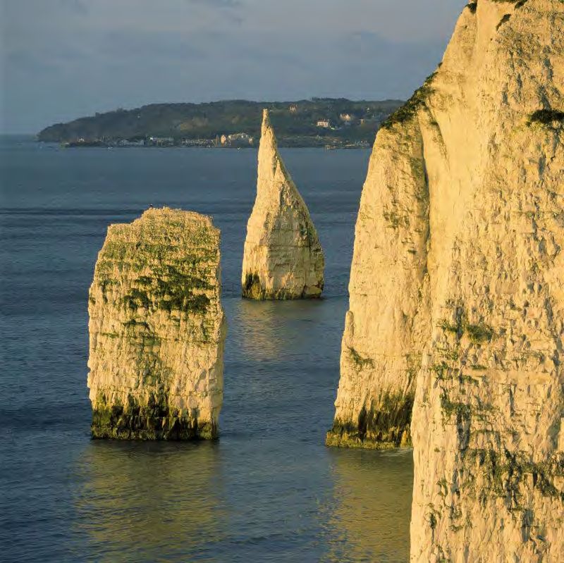
1. Introduction
The need for a written policy on how the National Trust will be managing coastal
change in Purbeck has been recognised for a considerable time. The recent
management issues at Middle Beach have amplified the need for such a document,
as well as for improved engagement concerning coastal change. This paper outlines
the key pressures faced along the 24 kilometres of the Purbeck coastline that we
care for, and sets out how we plan to create a sustainable future for these places.
All coastlines are subject to coastal change due to natural processes. The nature
and rate of this change depends upon numerous interacting factors; including
geomorphology, geology, climate and marine conditions. Climate change will put
increasing pressures on the coastline, such as sea-level rise and more frequent
storms. We know that this is likely to increase the rate of coastal change, having a
positive impact in some areas and a negative effect in others.

On the Isle of Purbeck we have an incredible variety of coastal landscapes, including
sandy beaches, towering limestone cliffs, rare lowland heath and rolling chalk
grasslands. The area forms part of the Dorset Area of Outstanding Natural Beauty
and is of exceptionally high nature conservation value due to its rich biodiversity.
Much of the Studland Peninsula is a National Nature Reserve as well as a Special
Area of Conservation and Ramsar site. The coastline west of Old Harry Rocks also
forms part of the Jurassic Coast World Heritage site. Each of these areas will
respond differently to climate change. Sea-level rise, for example, will have a
significant impact on Poole Harbour’s low-lying salt marshes. Knoll Beach on the
other hand is particularly vulnerable to an increased occurrence of storm events.

The communities living on the Isle of Purbeck have a strong connection to the coast
and Dorset’s maritime heritage. Ensuring that these communities and the public are
able to be actively involved in managing coastal change is imperative to driving the
development of innovative adaptation strategies. The area is also hugely popular
with tourists, attracting millions of visitors throughout the year. Ensuring that
everyone is able to enjoy and access the Purbeck coast is also an important part of
our coastal strategy.

Coastal management in Purbeck has been guided by the National Trust ‘Shifting
Shores’ set of policies, as well as the local Shoreline Management Plan (SMP2).
Developing sustainable and long-term plans is integral to this. We will also work with
nature wherever possible in order to create a healthier, more beautiful natural
environment. Using this approach people, the environment, and financial
considerations are viewed with equal weighting. This is to ensure that the most
appropriate policy is arrived at by maximising the benefits of all three factors while
minimising the risks.

                                                                                         3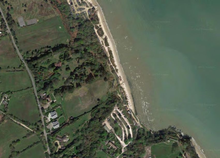
2. Background
2.1 Shifting Shores

In 2005 the National Trust launched its ‘Shifting Shores’ coastal change policy. The
aim was to encourage coastal properties to recognise and plan for the increasing
pressures that climate change will put on our coastline.

This policy is written at a national level. There is no singular ‘Shifting Shores’ policy
that will fit every coastal site. It is therefore important that we apply these principles
in Purbeck in such a way that takes account of the specific needs of the local
community and environment at each of our coastal places. Where there are legal
agreements which predate or have greater precedent these will by necessity
override our national coastal policy.
Since the launch of ‘Shifting Shores’ we have already witnessed some of the
challenges brought about by coastal change in Purbeck. In the winter of 2013/14, we
witnessed a succession of storms at Studland that resulted in a rate of erosion that
we might usually expect over 15 years. In order to reduce the negative impacts of
events such as this, it is crucial that we develop adaptive approaches to coastal
management. This includes working with the natural processes that shape our
shoreline, and where possible removing defences when they reach the end of their
working life. This is something that we are already putting into practice in Purbeck;
however there is more work to be done to ensure that we can make sustainable and
informed decisions.

The ‘Shifting Shores’ principles are summarised as follows:

•   The Trust accepts that the coast is dynamic and changing and will work with the
    natural processes of erosion and accretion wherever possible.

•   The Trust will take a long-term view and will adopt or support flexible
    management solutions which can enable, or adapt to, the processes of coastal
    change.

•   The Trust will plan in the context of projected sea-level rise and will favour
    coastal realignment wherever this can reasonably be accommodated.

•   The Trust will only support interference with natural coastal processes where it
    believes there is an overriding benefit to society in social, economic or
    environmental terms. This will usually be ‘buying some time’ in order for a longer-
    term adaptive solution to be negotiated with other parties.

•   Valued habitats and species of the coastal zone will be conserved and enhanced
    as far as practicable, accepting that they will develop or adapt in response to
    coastal, oceanic and climate change. The Trust accepts that some habitats and
    species will be lost or replaced through natural processes and we will attempt
    substitution of losses elsewhere. The relationship between terrestrial, intertidal

                                                                                             4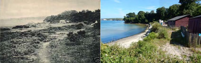
and marine species and ecosystems will be fundamental to the Trust’s
    management of and policies for the coastal zone.

•   Valued cultural features in the coastal zone will be conserved and enhanced as
    far as practicable, whilst not necessarily seeking to protect them indefinitely.
    The Trust will ensure such features are properly recorded before they are lost
    or will consider relocation if that can be justified. The relationship between
    landscape and seascape and the full meaning of the maritime historic
    environment will be fundamental to the Trust’s management.

•   The Trust will actively promote public access to the coastal zone, subject to
    conservation and safety considerations, in order to provide public enjoyment,
    recreational opportunities and to develop understanding of the coast and
    marine environments.

•   Coastal management decisions often impact beyond their immediate location.
    The Trust will work with other managers, organisations and communities to
    share experience and knowledge, to secure beneficial outcomes, to promote
    solutions on the basis of our experience, and to ensure a shared understanding
    is achieved.

•   The Trust will only support development in the coastal zone which has taken
    proper account of coastal change and sea-level rise as well as environmental,
    cultural and landscape considerations. The Trust will contribute to components
    of the terrestrial and marine spatial planning systems to ensure its interests are
    fully reflected in plans and policies.

•   The Trust will consider the acquisition of land and property where it is the best
    option to support these principles. This can include land on the present coast,
    land to be managed as future coast, land in intertidal areas and land as seabed
    - as freehold or leasehold.

2.2 Shoreline Management Plans

Shoreline Management Plans (SMPs) are Government plans that set out options for
how a section of coast should be managed over the next 100 years. Their purpose
is to provide local authorities and agencies with a framework for managing the
coast sustainably, based on extensive monitoring and data analysis by a wide
range of experts and organisations. The latest SMP for much of the Purbeck coast
(SMP2) was produced by the Poole and Christchurch Bays Coastal Group in 2011.
The coastline west of Durlston Point is covered by the South Devon and Dorset
SMP2. A refresh of the 2011 SMP is taking place in 2019 to make sure the plans
are up to date, reliable and visible and remain a ‘living’ document however there is
no likelihood that cell policies will change.

 Our Purbeck Coastal Management Policy is guided by the SMP even though it is
not mandatory to follow it. We choose to follow it because the quality of the data
collected is very high and summarises the best current knowledge of the processes
occurring along the coast. In addition to monitoring carried out by the Trust this
allows for a good estimation of potential future erosion rates.
                                                                                         5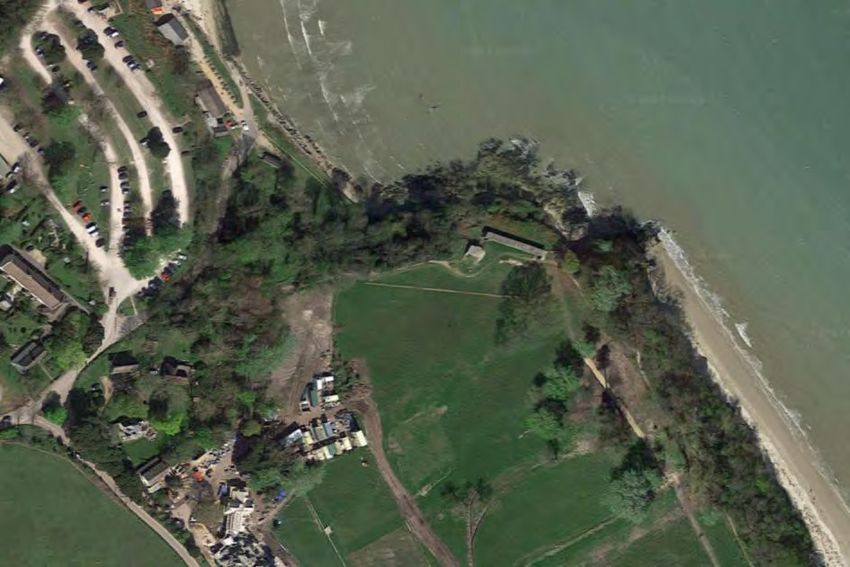
Furthermore, Integrated Coastal Zone Management (ICZM) has been widely
recognised as best practice for many years now. Essentially ICZM means aiming for
a coordinated application of policies along the coast; so that all authorities are
working to the same timescales and using the same framework to form the
foundation of their own local strategy. If this approach is not followed this can result
in ‘piecemeal’ management of the coast, which can be highly inefficient and often
have detrimental impacts to adjacent parts of the shoreline. Coastlines don’t
recognise landowner boundaries, it is therefore vital we consider our places within
the context of the wider SMP2 area.

 2.3 Climate Change and the Coast

 The rate at which the Earth’s surface is warming has accelerated in the 21st
 century, with 2016 being the hottest year on record (NASA, 2017). More energy in
 the atmosphere and oceans will have a significant and diverse effect on our
 coastline, and will increase the rate of coastal change we experience.
 In recent years our winters have been getting noticeably warmer and wetter. More
 frequent storm events are likely to cause sudden and dramatic changes to the
 Purbeck coastline. The beaches of Studland are most vulnerable to storms from
 the east. What is particularly critical is the recovery time between these events; as
 this determines to what extent the beach and dunes can naturally replenish.
 Flooding events from the sea will also become more regular, particularly when
 storms coincide with high tide events.
 During the summer we have seen an increase in extreme precipitation events as
 well as prolonged drought episodes. These weather conditions increase the
 likelihood of landslides and cliff falls. Rising temperatures and more extreme
 weather will also mean that some coastal species may decline or migrate to new
 areas if they are unable to adapt. Conversely other more tolerant species may
 thrive under these new conditions. It is also likely that we will see the arrival of new
 species from warmer climes.
 Sea-levels are currently rising at a rate of 3 mm a year in South West England and
 this is projected to increase over the 21st century (IPCC, 2013). Areas of low
 elevation will be most vulnerable to flooding and the effects of increased salinity.
 Coastal squeeze – when habitats become trapped between an encroaching sea
 and a fixed landward boundary – will have a significant impact at Middlebere and
 the Studland Peninsula. The National Trust will continue to mitigate for habitat loss
 where possible and will work with other organisations to achieve this.
 Climate change will have a significant impact on those who live and work at the
 coast. Implementing sustainable adaption strategies now will better prepare these
 communities and businesses for the future. It will also help to maximise any
 opportunities that will come from coastal change.
 Visitor access will also be impacted by coastal change, and therefore the way in
 which visitors use the coast may change. Some car parks, footpaths, beach huts
 and facilities may need to be relocated over forthcoming decades. Knoll Beach is
 particularly vulnerable due to its exposed location and huge footfall. The loss of
                                                                                            6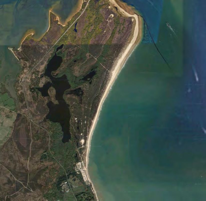
these facilities would have a significant impact on our ability to manage access to
the nature reserve and Studland’s beaches, as well as on property income.

2.4 Communication and Engagement Strategy

An effective communication and engagement strategy is crucial to ensuring the
successful delivery of coastal management policy. Consistent, collaborative and
thoughtful communication drives the development of innovative practices to enable
coastal communities to thrive in an ever-changing environment. It also ensures that
all relevant stakeholders have the opportunity to be actively involved in caring for the
coast; which in turn can build valuable working relationships between the National
Trust and local partners.
Our Communication and Engagement Strategy for the Purbeck Coast was produced
in autumn 2017 and is designed to directly support the policies outlined in this
document.

2.5 Coastal Monitoring

Since 2011 the National Trust has undertaken quarterly coastal monitoring surveys
between Shell Bay and South Beach using a combination of GPS and fixed point
photography. This has provided us with a record of changes in the position of the cliff
line, dune toe and strandline. This information is used in conjunction with annual
data collected by the Channel Coast Observatory at fixed points along the Purbeck
coast.
In September 2017 we will be recommencing our coastal monitoring programme and
extending it to include our other coastal places beyond Studland. For the inner
harbour our priority will be to record changes to coastal habitats and the extent of the
salt marsh. We monitor saltmarsh condition annually as part of the priority habitats
monitoring programme and this will be referred to in future coastal monitoring
reports. For the cliffs that we manage from The Warren to Winspit, the priority will be
to record potential safety and access issues as a result of landslides using data
collected by external agencies. Since 2011 we have also coordinated regular seabird
monitoring along the South Purbeck coast and have plans to monitor visitor impact in
the same areas.
The new coastal monitoring report will be published in 2018, and is planned to be
compiled annually thereafter.

                                                                                           7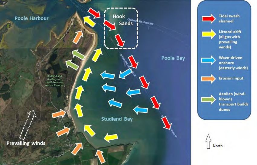
3. Coastal Management Policy Description
  The 24 km of coastline in Purbeck that we care for has been divided into 12
  areas (figure 3.1). Table 3.1 provides an overview of the proposed coastal
  management policy assigned to each place over three time periods: Short-
  term (up to 2025); medium-term (up to 2055); and long-term (up to 2105).
  This mirrors the framework utilised in the Shoreline Management Plan
  (SMP2). Four broad policies are used to describe how the coastline could be
  managed; the specific implementation of these for each site is then discussed
  in further detail below.

  •   Hold The Line (HTL) – hold the current position by defending whatever is at risk.

  •   Managed Realignment (MR) – allowing the shoreline to retreat or
      advance in a controlled and managed way.

  •   No Active Intervention (NAI) – allowing nature to take its course
      either on undefended coast or by the removal of current defences.

  •   Advance The Line (ATL) – the building of new coastal protection
      on the seaward side of existing defences.

  Table 3.1: Summary of proposed coastal management policies in Purbeck

                                              Period 1            Period 2       Period 3
                Area                        Short-term         Medium-term     Long-term
                                           (up to 2025)         (up to 2055   (up to 2105)

        Middlebere Peninsula                 MR / NAI              NAI           NAI
Brands Bay and Bramble Bush Bay              MR / NAI              NAI           NAI
         South Haven Point                    HTL                 HTL            HTL
              Shell Bay                        NAI                 NAI           NAI
         The Training Bank                    HTL                 HTL            HTL
              The Knoll                      MR / NAI            MR / NAI        NAI
           Middle Beach                      MR / NAI              NAI           NAI
          Redend Point                         NAI                  NAI           NAI
           South Beach                       MR / NAI               NAI           NAI
   The Warren to Handfast Point                NAI                  NAI           NAI
  Handfast Point to Shep’s Hollow              NAI                  NAI           NAI
       Belle Vue to Winspit                    NAI                  NAI           NAI

                                                                                        8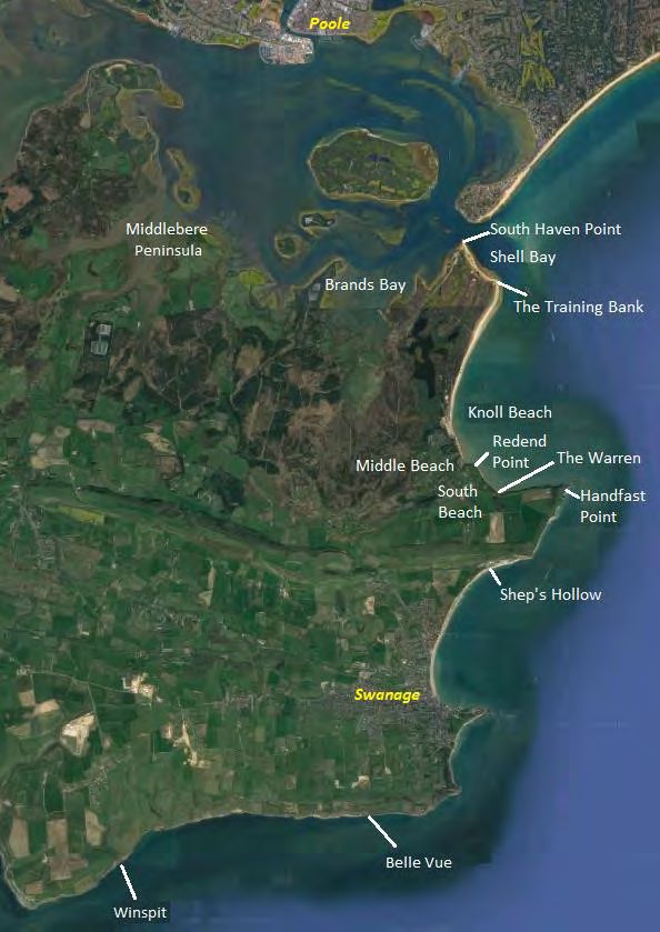
Bramble
                                                         Bush Bay

Figure 3.1 Map of coastal management policy areas in Purbeck (Aerial image: Google, 2017).

                                                                                             9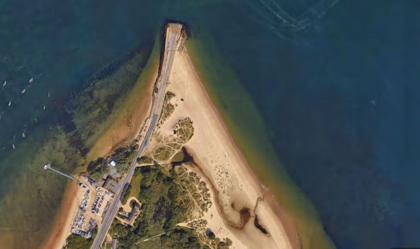
3.1 Middlebere Peninsula

Middlebere lies on the sheltered southern shore of Poole Harbour and is an excellent
place to watch wildlife. The harbour is a SPA and Ramsar site due to its reed beds,
saltmarsh and intertidal mudflats that provide a rich habitat for birds. The adjoining
heathland is a designated SPA and SAC. The area also has a rich industrial and
agricultural heritage. The Middlebere Plateway was the first railway in Dorset when it
was built in 1805 to transport clay from workings near Corfe Castle to Poole Harbour.
The peninsula is still a working landscape with grazing land down to the shoreline.

                          Middlebere Peninsula

        Period 1                         Period 2                       Period 3
        MR / NAI                           NAI                            NAI

Sea-level rise will have a significant impact at Middlebere due to its low elevation
and extensive intertidal habitat. Coastal squeeze will result in the loss of some of the
mud flats, saltmarsh and reed beds, particularly over the second and third periods.
Some of these habitats will migrate where they are not restricted by areas of higher
elevation or hard structures. Over the first period we will continue to establish areas
that could be flooded to help compensate for this habitat loss, such as agricultural
land. We are sometimes prevented from doing this by the threat of loss to our Basic
Payment Scheme funding.

An increase in temperature and shifting weather patterns is likely to have an impact
on the various habitats at Middlebere, although it is not clear which species will be
most affected. A moderate rise in the annual average temperature can actually
increase vegetation productivity and favour marsh expansion; however prolonged
dry hot summers can depress this (Robins et al., 2015). More regular heavy rainfall

                                                                                        10
events are likely to boost sediment supply to intertidal areas, which will help vertical
saltmarsh growth (Fagherazzi et al., 2013).
Higher sea-levels will also result in more regular tidal flooding. The Middlebere Farm
holiday cottages will become increasingly vulnerable to flood events. The remains of
Middlebere Quay will likely be lost due to higher water levels. These have already
been recorded by the Purbeck Mineral and Mining Museum. The valleys that flow
into Poole Harbour either side of the peninsula will also flood more regularly over the
second and third periods. This will impact farmland as well as Hartland Moor
National Nature Reserve located upstream. Vehicular access to the Corfe - Arne
road will also be increasingly affected.
With the exception of some managed realignment to compensate for habitat loss, a
policy of no active intervention will be implemented at Middlebere. Working with
natural processes will allow these valuable habitats to migrate freely within the
harbour. Working with other conservation organisations will be crucial to ensuring the
sustainable management of this area. The RSPB are also identifying areas suitable
for managed realignment at Arne Nature Reserve, which lies just across the channel
from the Middlebere peninsula.
Saltmarsh and reed beds at Middlebere
Proposed actions for Middlebere Peninsula
• Continue to identify areas suitable for habitat compensation in the first period
• Continue to work with other conservation organisations and landowners in the
area to implement this; particularly the RSPB, Environment Agency and local
farmers
• Plan for structural moves and road access issues during the third period
• Raise greater awareness of coastal change at Middlebere with the public
• Include Middlebere Peninsula in future coastal monitoring reports. The priority
will be to record ecological changes.
113.2 Brands Bay and Bramble Bush Bay
Brands Bay and Bramble Bush Bay lie on the southern shore of Poole Harbour and
are sheltered from the open sea by the Studland Peninsula. The mudflats and
saltmarsh at Brands Bay are an excellent place to watch wildlife. The harbour is a
SPA and Ramsar site due to the rich habitat it provides for birds. The adjoining
heathland is a designated SPA, SAC and National Nature Reserve. The Bays are
popular with walkers as at low tide it is possible to walk around the perimeter of the
Bays from the Sandbanks Ferry to join the cycle path at Studland Heath. There are
also small areas of sheltered sandy beach and low level cliffs that can be easily
accessed from the main road.
Bramble Bush Bay
Brands Bay
Period 1 Period 2 Period 3
MR / NAI NAI NAI
Sea-level rise will result in the loss of some of the mud flats, saltmarsh and beaches,
particularly over the second and third periods. We know from the Cyril Diver Project
that the salt marsh today is already one third of its recorded size in 1936. This
decline however may not be entirely due to changes in sea-level: the Spartina
anglica cord-grass that dominates this habitat is a hybrid of the native species that is
thought to be genetically deteriorating over time. Furthermore, the excess of nitrogen
in the harbour sediments (primarily from agricultural runoff) has led to a lower root:
shoot ratio in the Spartina and thus greater vulnerability to erosion.
12Unlike Middlebere there is less suitable land available to compensate for this loss.
Allowing nature to take its course therefore provides these habitats with the best
chance of being able to migrate and adapt to changes in sea-level and salinity
Saltmarsh migration in the area around Greenlands Paddocks is impeded by the
fence line and scrub that has built up around it, forming an artificial step between the
paddocks and the intertidal zone. We have done some work to remove the fencing
and scrub but more needs to be done. As at Middlebere we are sometimes
prevented from doing this on agricultural land by the threat of loss to our Basic
Payment Scheme funding.
As discussed in the previous section it is unknown exactly what the impacts of shifts
in weather patterns will be on this habitat. Gradual increases in temperature can be
beneficial to salt marsh growth; however prolonged hot spells can be detrimental to
this.
It is unlikely that the buildings at Greenlands Farm will be at risk of flooding from the
sea, although some land is likely to be lost in the second and third periods. A small
number of privately owned houseboats are moored near to South Haven Point.
Those that are on concrete bases will become increasingly vulnerable to flooding
and high tide events.
Walking access around the perimeter of the Bays will also become increasingly
difficult during the first period. Scouring of the low level cliffs is also likely to increase
resulting in more regular cliff falls.
Proposed actions for Brands Bay and Bramble Bush Bay
• Continue to identify areas suitable for habitat compensation in the first period
• Continue to work with other conservation organisations and landowners in the
area to implement this; particularly the RSPB, Natural England and local
farmers
• Raise greater awareness of coastal change in the Bays with the public
• Include Brands Bay and Bramble Bush Bay in future coastal monitoring
reports. The priority will be to record ecological changes
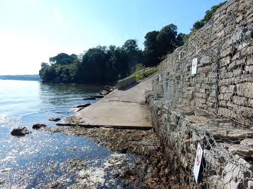
3.3 South Haven Point
South Haven Point lies at the tip of the Studland Peninsula at the narrow entrance to
Poole Harbour. The Bournemouth – Swanage Motor Road and Ferry Company have
run the Sandbanks chain ferry service here since 1923. The company also own
Ferry Road and its verges on the Studland Peninsula. The ferry is used extensively
by locals and visitors throughout the year, and is an important commuter route
between Purbeck and the Poole and Bournemouth conurbation. Shell Bay Marine
has a small car park area, a restaurant and moorings on the western side of the spit
which is leased from the National Trust. We own and manage the car park and toilet
facilities located on the eastern side of the road. The ferry slipway and road is
protected by rock armour which is maintained by the Ferry Company.
13South Haven Point
Period 1 Period 2 Period 3
HTL HTL HTL
Whilst we do not manage the road and slipway at South Haven Point it is important
that we work with the Ferry Company to ensure a sustainable future for this transport
link. A hold the line policy is in place in order to protect the viability of this critical
transport route to and from the Isle of Purbeck. Ferry Road will become increasingly
susceptible to flooding from the sea, particularly during the second and third periods.
The Ferry Company repaired and extended the slipway in 2008 and it is likely that
this will be required more frequently in the future due to sea-level rise and increased
storminess. The infrastructure at Shell Bay Marine will become increasingly
vulnerable to flood events, particularly during extreme tides. An adaptation strategy
should be discussed during the first period in order to reduce the risks from climate
change.
Ferry Road will become increasingly susceptible to flooding from the sea
14Proposed actions for South Haven Point
• Continue to work with the Bournemouth – Swanage Motor Road and Ferry
company to maintain road access to the slipway
• Work with Shell Bay Marine to discuss potential adaption strategies during the
first period
• Continue coastal monitoring programme
• Raise greater awareness of the reasons for a hold the line policy at the ferry
slipway
3.4 Shell Bay
The wide sandy beach at Shell Bay lies at the northern extent of the Studland
Peninsula. This end of the spit has been shaped by a combination of wind, waves
and the strong tidal currents that flow in and out of Poole Harbour entrance. The
beach is backed by a series of dunes and heathland habitat, marking the northern
extent of the National Nature Reserve. Renowned for its natural beauty, Shell Bay is
very popular with visitors and locals alike, being just a short hop over the ferry from
the urbanised beaches of Sandbanks.
Shell Bay
Period 1 Period 2 Period 3
NAI NAI NAI
Sediment transport in Shell Bay is complex and is significantly influenced by the two
large defences at either end of the Bay (the Training Bank and the ferry slipway).
Appendix A discusses sediment transport for the Studland Peninsula in greater
detail.
Over seasonal timescales, the beach undergoes cycles of erosion and accretion
dependent on weather conditions and sediment supply. During storm events several
metres of material can be removed overnight, lowering the level of the beach and
causing ‘cliffing’ on the foredunes. Provided there is enough time between storm
15events the beach and dunes will recover during calmer weather as sediment is
returned to the system.
Over annual timescales broader patterns of coastal change emerge. Significant
accretion occurs at the northern end of the Bay, as is evident from the presence of
embryo dunes. This is due to the direction of the prevailing wind and longshore drift.
The rate of accretion here is currently 1 metre per year (figure 3.2).
16Figure 3.2 The advancing dune toe at Shell Bay (Doug Whyte 2015)
It is likely that these general patterns of coastal change will continue during the first
period, although more frequent storms and high tide events might reduce the net rate
of accretion. During the second and third periods sea-level rise will become an
increasing stressor at Shell Bay and could result in the loss of some dune habitat.
Dunes are naturally dynamic habitats that are far more resilient to the pressures of
sea-level rise and storms if sediment is able to move freely around the system. This
17is why a policy of no active intervention has been chosen for Shell Bay over the three
time periods. Continuing to manage visitor access to the dunes however will be
critical to ensure that the dunes are able to respond to shifting climate conditions.
Left: Erosion of the dunes near Pilot Point during the winter of 2013/14. Right: New dunes being
colonised by marram grass (Images: Doug Whyte)
Proposed actions for Shell Bay
• Raise greater awareness of coastal change at Shell Bay with the local
community and visitors
• Continue coastal monitoring programme and expand to include regular
surveys of the dune profile. This should be linked to our extensive ecological
survey work
• Continue to manage visitor access to the site to reduce damage to the dune
system through trampling
• Maintain safe access to the South West/English Coast Path and realign if
necessary
3.5 The Training Bank
The Training Bank is a 1.5 km long rock groyne that was constructed in 1860 to
protect the entrance of Poole Harbour from silting up. It was extended in two phases,
the first in 1876 and then in 1927. The structure has a significant influence on the
morphology of the Studland Peninsula, contributing to the high rate of accretion at its
northern extent and interrupting longshore sediment transport. Any maintenance
issues regarding the Training Bank have always been dealt with by Poole Harbour
Commissioners.
18The Training
Bank
Period 1 Period 2 Period 3
HTL HTL HTL
Sea-level rise and increased storminess will put increasing pressure on the Training
Bank. For commercial reasons it is critical that the structure remains in place to
prevent the silting up of the swash channel leading to Poole Harbour.
Proposed actions for The Training Bank
• Continue to work Poole Harbour Commissioners to enable the Training Bank
to be maintained
• Raise greater awareness of the reasons for a hold the line policy
3.6 Knoll Beach
Knoll Beach is an extensive sweeping sandy beach that is backed by Studland and
Godlingston Heath National Nature Reserve. The Studland dunes themselves are
unusual because they are made of acidic sand with very low shell content. This
acidity means that after about 60 years, when the roots of the marram grass have
anchored the sand in place, they become colonised by heather, creating a rare
habitat known as dune heath. With more than 75 hectares, Studland is the largest
area of dune heath on the south coast. Subsequently Knoll Beach is known not just
as a place for leisure, but is highly regarded as a unique educational resource. This
stretch of coastline also includes the Knoll visitor centre and facilities, including the
main car park for beach users.
19Knoll Beach
Period 1 Period 2 Period 3
MR / NAI MR/ NAI NAI
In morphological terms the Studland Peninsula is very young: the majority of the
beach north of the visitor centre has been deposited over the last 500 years. Over
this time large quantities of offshore sand has been blown onshore and shaped by
the winds to create the extensive dune system. Over this time the dune ridges
formed a barrier that separated large areas of water from the sea. Rainwater has
flushed through these dunes slacks gradually turning these wetlands from salt to
freshwater. The freshwater lake at Little Sea is of international ecological
importance, and at 33 ha is the largest lowland oligotrophic lake in Britain. It is home
to specialist plants and invertebrates as well as providing a sheltered refuge for birds
and animals.
Little Sea provides a unique freshwater habitat (Image: Will Wilkinson)
20Knoll Beach is an incredibly dynamic environment and the topography will fluctuate
regularly in response to weather and marine conditions. The northern end of Knoll
Beach is still experiencing a pattern of accretion of up to one metre per year.
However the southern end nearer the visitor facilities experiences erosion at a
baseline rate of 0.6 metres per year (SMP2, 2011).
The dunes at the northern extent of the Knoll are accreting at a rate of 1 metre per year (left). The
dunes at the southern extent of the Knoll however are experiencing erosion, as seen by the
undercutting of the foredunes (right) (Images: Doug Whyte, 2016).
At the northern extent of Knoll Beach it is likely that the dune heath system will
gradually migrate landward over the second and third periods as sea-level rises.
There is uncertainty as to how long a pattern of accretion will be maintained on the
beach, and also how far the dune system will be able to migrate. A policy of no active
intervention over this stretch of Knoll Beach will allow the dunes to respond to
changing climatic conditions and enable this migration to take place. Little Sea
however will not be able to roll back, and by the second period it is likely that the lake
will have become saline, therefore changing its ecology substantially (NT, 2008). A
sudden breach of Little Sea would also result in a ‘dam bursting’ effect: water levels
that have continued to rise over the past century will suddenly drop again. Over the
third period the mires of Studland Heath will become increasingly susceptible to
flooding from the sea.
There is also a possibility of Second World War ordnance being exposed by erosion.
This will need to be monitored particularly after storm damage and loss of significant
quantities of beach material.
Increasing storminess and sea-level rise will result in damage and the eventual loss
of infrastructure located at the southern end of Knoll Beach. The Visitor Centre, car
park and toilets are extremely vulnerable from storm events and will need to be
relocated during the early second period. Some beach huts are likely going to need
to be moved during the first period. The National Trust derives much of its income
21from visitors coming to Studland enabling it to pay for its conservation work and
maintain its built property in Purbeck. With the prospect of warmer, drier summers, it
is likely that the current figure of 1.5 million visitors per year could increase
substantially. The Studland Peninsula would be unlikely to cope with increased
visitor pressure on a site reduced in area as a result of coastal erosion.
Visitor facilities at Knoll Beach are vulnerable to storm damage and flooding
Holding the line in front of the visitor facilities would not be a sustainable
management option. When waves hit a hard structure they are reflected, resulting in
scouring of the sand in front of the defence. Over time this causes the beach to lower
as sand will not accumulate. At nearby Middle Beach, the beach has lowered by 2
metres between 2003 and 2012 in front of the gabions, compared to 1 metre where
the coast is not defended (SCOPAC, 2014). Sediment transfer to the northern part of
the peninsula would also significantly reduce. Beach replenishment is another
alternative but cannot be justified in terms of both financial cost and on
environmental grounds. Groynes would also need to be installed in order to make
this a viable option. A roll back strategy will therefore be implemented where
infrastructure is located that will allow the Trust to manage its retreat in an
economically sustainable way.
Proposed actions for Knoll Beach (Shell Bay to the visitor centre):
• Raise greater awareness of coastal change at the Knoll and Studland Heath
with the local community and public
• Continue coastal monitoring programme and expand to include regular
surveys of the dune profile and the dune heath habitat. This should be linked
to our extensive ecological survey work
• Continue to manage visitor access to the site to reduce damage to the dune
system through trampling
22• Maintain safe access to the South West/English Coast Path and realign if
necessary
• Continue to monitor for Second World War ordnance
Proposed actions for Knoll Beach (visitor centre to Middle Beach):
• Plan for relocation of visitor facilities and some beach huts within the first
period, working closely with Purbeck District Council (PDC) and Natural
England.
• Work with Dorset County Council, PDC and transport groups to implement
an alternative means of transport to Studland in light of reduction in car
parking space over the second and third periods.
• Continue engagement with the local community, Studland Parish Council
and wider user groups on coastal management issues
• Maintain safe access to the South West/English Coast Path and realign if
necessary
• Continue to monitor coastal change
• Once facilities have been relocated a policy of no active intervention shall
be implemented
3.7 Middle Beach
Middle Beach has been at the heart of the Studland community for generations and
is also popular with swimmers and kayakers. The site is bordered by the sandstone
cliffs of Redend Point to the south and Knoll Beach to the north. The mixture of
woodland, dune and beach habitat provides a unique setting for beach huts as well
as the Middle Beach café. The intermittent Coombe stream flows out to sea via
Middle Beach.
23Middle Beach
Period 1 Period 2 Period 3
MR / NAI NAI NAI
Old maps and photographs show that beach and slope erosion have been occurring
at Middle Beach for well over 100 years. The shape of the bay combined with the
direction of longshore transport means there is a net deficit of sediment supply to the
beach. The gabion baskets protecting the cliffs at the southern extent of Middle
Beach have added to the problem by causing the beach levels to drop in recent
years. The beach has lowered by 2 metres between 2003 and 2012 in front of the
gabions, compared to 1 metre where the coast is not defended (SCOPAC,
2014).These defences are now reaching the end of their working lives and have
become a hazard. This also means that the café and toilet facilities at the cliff edge
have become increasingly vulnerable to slope erosion.
th
Left image: Old photographs show the extent of the beach in the early 20 century (image courtesy of
Tony Freer). Right image: Middle Beach today (Sarah Spinney)
24Beach lowering in front of the gabions means that the slipway route to the beach is now inaccessible
at high tide. Seaweed regularly accumulates in this area (Image: Sarah Spinney)
Instead of rebuilding the defences, we want to find a new location for the café and
toilet facilities. The café has been moved several times in the past due to erosion, as
have many of the beach huts. Since autumn 2016, we have been working with
Studland Parish Council and community representatives to find a sustainable
solution for Middle Beach and its facilities. Once the café and toilets have been
moved, the defences will be removed allowing the shoreline to adjust to a natural
state.
During the first period removal of the defences is likely to initially result in a more
rapid rate of erosion as the soft sandy cliffs retreat to a more natural alignment. As
the cliff erodes this will release some sediment into the system allowing the beach to
naturally replenish. This will in turn protect the toe of the cliff and eventually reduce
the rate of erosion that occurs. The creation of a slowly eroding soft cliff will also
bring direct ecological benefits by providing an important habitat for pioneer plant
and invertebrate communities. However, more frequent episodes of extreme rainfall
and drought will put an increased pressure on slope stability.
Over this time it is very likely that more of the beach huts will need to be relocated. It
is also likely that some of the car park area will be lost. Gradual relocation of facilities
where possible will therefore continue over this period.
Over the second and third periods natural processes will be allowed to continue. A
narrow beach will remain as long as sea-level permits.
Proposed actions for Middle Beach:
• Continue with plans to relocate the café and toilet facilities to a safer location
• Continue engagement with the local community, Studland Parish Council and
wider user groups on coastal management issues
25• Monitoring of the rock gabions for safety purposes until the facilities have
been relocated. Remove all defences after this point to allow natural
processes
• Continue to relocate beach huts as necessary and where possible
• Continue to monitor coastal change
• Maintain safe access to the South West/English Coast Path and realign if
necessary
3.8 Redend Point
Redend Point is formed from a harder band of iron rich sandstone that is more
resistant to erosion than the surrounding geology. Subsequently it has a significant
influence over longshore coastal processes. It is also a designated SAC and SSSI.
Remnants of Studland’s military past are clear to see at Redend Point: Fort Henry is
a grade II listed bunker that was built solely for viewing preparation exercises for the
D-Day landings in Normandy.
Redend Point
Period 1 Period 2 Period 3
NAI NAI NAI
Redend Point is eroding at a mean rate of 0.4 metres per year (SMP2, 2011). This
rate of recession will continue over the first period but is likely to increase thereafter.
Fort Henry will become increasingly vulnerable to erosion over this time. Whilst
visitor access to the site may be impacted it is unlikely that the structure will be
entirely lost before the third period. Cliff falls may become more common from the
unconsolidated sandy cliffs particularly after periods of heavy rainfall. At present
South Beach can be reached from Middle Beach via the foreshore at Redend Point
at low tide. This access will become increasingly reduced over the first period. The
eroding cliff face does however provide a unique habitat for invertebrates,
particularly burrowing aculeate hymenoptera.
26Pill box at the base of Redend Point (Image: Will Wilkinson)
Proposed actions for Redend Point:
• Realignment of permissive coastal path if required
• Continue engagement with the local community, Studland Parish Council and
wider user groups on coastal management issues and the history of the site
• Continue to monitor coastal change
3.9 South Beach
South Beach, fondly known as Little Beach or Stoney Beach, is incredibly important
to the heritage of Studland village. Tucked away behind vegetated cliffs, the
sheltered sandy beach is popular with swimmers and families. The site provides a
unique setting for beach huts as well as Joe’s café. Coastal change here is slower
than at the other beaches of Studland, as South Beach is protected from the
prevailing winds by Handfast Point.
27South Beach
Period 1 Period 2 Period 3
MR / NAI NAI NAI
Sea-level rise will have a significant impact at South Beach as there is little room for
managed realignment and the beach is already very narrow. The gabion baskets
currently protecting the beach huts here are in relatively good condition compared to
those at Middle Beach. In this low energy environment it is likely these will remain
over the first period. When these structures are no longer deemed feasible to
continue to be repaired, the National Trust does not plan to replace them and will
instead remove the gabion baskets and allow the beach to develop naturally. The
beach will become narrower over time. Alternative locations and or management
methods for beach huts will need to be investigated.
There is a possibility that by the third period, some erosion of garden land either side
of the beach café will occur. Towards The Warren the unstable loose sand cliff
abutting the chalk will continue to erode. The Studland Cliffs SSSI and Portland to
Studland Cliffs SAC will be affected but the habitat will survive by species continually
colonising newly exposed cliff.
28Left image: Old photographs show the extent of the beach in 1927 (image courtesy of Tony Freer).
Right image: South Beach today (Will Wilkinson)
Proposed actions for South Beach:
• Continue engagement with the local community, Studland Parish Council and
wider user groups on coastal management issues; including the options for
the beach huts and cafe
• Remove gabion baskets when they are no longer deemed repairable
• Continue to monitor coastal change
3.10 The Warren to Handfast Point
The Upper Cretaceous chalk of the Warren marks a distinct shift in geology from that
of the Studland Peninsula. It also marks the eastern extent of the Jurassic Coast
World Heritage Site. The sea stacks at Handfast Point, better known as Old Harry
Rocks, are an iconic Dorset landmark. Subsequently this is a very popular stretch of
the South West Coast Path, giving ramblers incredible views out over Poole Bay.
The vegetated cliffs also form part of the designated SAC.
29Handfast Point
The Warren
Period 1 Period 2 Period 3
NAI NAI NAI
The cliffs are eroding slowly at a mean rate of 0.3 metres per year (SMP2, 2011).
This gradual changed is marked with episodic cliff fall events where larger amounts
of material may be lost. These are largely unpredictable, although more frequent
fluctuations between periods of extreme rainfall and extreme drought over
forthcoming decades is likely to result in more regular cliff falls.
Kayaking past the iconic Old Harry Rocks (Image: Ben Selway)
Old Harry Rocks before and after the winter of 2013-14 (Images: Elli Macdonald)
30The only intervention at the site will be to maintain the safety of the coast path and
visitor access to the area.
Proposed actions for the Warren to Handfast Point:
• Maintain safe access to the South West/English Coast Path and realign when
necessary
• Include cliffs in future coastal monitoring reports. The priority will be to record
potential safety and access issues as a result of landslides using data
collected by external agencies
3.11 Handfast Point to Shep’s Hollow
The stretch of coast path over Ballard Down is very popular with walkers, giving
excellent views over the iconic chalk sea stacks of Old Harry Rocks and the
Pinnacles, as well as nearby Swanage. The cliffs are part of the designated SAC,
and are a great place to see chalk grassland flowers.
Handfast
Point
Shep’s Hollow
Period 1 Period 2 Period 3
NAI NAI NAI
The cliffs are exposed to the prevailing south westerly winds and are eroding at a
mean rate of 0.7 metres per year (SMP2, 2011). As with other cliff areas, it is likely
that more frequent fluctuations between periods of extreme rainfall and extreme
drought over forthcoming decades will result in more regular cliff falls.
31A landscape created by erosion: The Pinnacles looking towards Swanage (Image: Joe Cornish)
The only intervention at the site will be to maintain the safety of the coast path and
visitor access to the area. Two Bronze Age barrows, which are designated as
Scheduled Ancient Monuments, are at risk from coastal erosion. Some farmland at
Whitecliff Farm is vulnerable to coastal erosion, particularly during the second time
period.
Proposed actions for Handfast Point to Shep’s Hollow:
• Maintain safe access to the South West/English Coast Path and realign when
necessary
• Include cliffs in future coastal monitoring reports. The priority will be to record
potential safety and access issues as a result of landslides using data
collected by external agencies
3.12 Belle Vue to Winspit
The south coast of the Isle of Purbeck is a distinctive landscape of towering
limestone cliffs, coastal grasslands and quarries. Purbeck stone has been prized by
masons for centuries and is very important to Dorset’s industrial heritage. A once
thriving quarrying industry continues at a reduced scale today, while older workings
have become cherished parts of the landscape. The cliffs are a popular location for
rock climbing and coasteering. The grasslands are rich in plantlife, and are one of
the best sites in Britain to see the rare early spider orchid.
32Belle Vue
Winspit
Period 1 Period 2 Period 3
NAI NAI NAI
The cliffs between Belle Vue and Winspit are very resistant to erosion despite being
subjected to high wave action. Cliff collapse will be mostly confined to areas where
joints in the cliff are exposed, such as at Winspit. Negligible cliff line movement is
predicted over the three time periods; however landslips and slumping are likely to
occur more regularly as a result of more extreme weather conditions. No
infrastructure is at risk from coastal change; however there could be a need to
realign the coast path to maintain safe access to the area. During the third period it is
possible the pool at Dancing Ledge could be submerged depending on the rate of
sea-level rise.
The coast falls under a number of ecological and landscape designations including
the South Dorset Coast SSSI; Portland to Studland Cliffs SAC; Dorset AONB; and
the Jurassic Coast World Heritage Site. Some grassland areas could be lost a result
of coastal change but this would be minimal.
The only intervention at the site will be to maintain the safety of the coast path and
visitor access to the area.
33Dancing Ledge is a disused stone Quarry on Purbeck’s Jurassic Coast (Image: Joe Cornish)
Proposed actions for Belle Vue to Winspit:
• Maintain safe access to the South West/English Coast Path and realign when
necessary
• Include cliffs in future coastal monitoring reports. The priority will be to record
potential safety and access issues as a result of landslides using data
collected by external agencies.
344. References
Fagherazzi, S., P.L. Wiberg, S. Temmerman, E. Struyf, Y. Zhao, P.E. Raymond Fluxes of water,
sediments, and biogeochemical compounds in salt marshes Ecol. Process, 2 (2013), p. 3
NASA/NOAA (2017) NASA, NOAA Data Show 2016 Warmest Year on Record Globally,
https://www.nasa.gov/press-release/nasa-noaa-data-show-2016-warmest-year-on-record-globally
National Trust (2008) Exploring future implications of climate change for three National Trust areas in
Dorset, https://www.dorsetforyou.gov.uk/media/pdf/8/r/DCF National_Trust_Scenarios_Report.pdf
Robins, P.E. et al 2015 Impact of climate change on UK estuaries: A review of past trends and
potential projections Estuarine, Coastal and Shelf Science Volume 169, 5 February 2016, Pages 119-
135
Shoreline Management Plan 2, available at http://www.twobays.net/smp2.htm and
http://www.sdadcag.org/SMPd2r.html
SCOPAC (2004) Sediment Transport Study, http://www.scopac.org.uk/sts-2012.html
SCOPAC (2014) Sediment Stores and Sinks Study,
http://www.scopac.org.uk/Final_stores_sinks_2014%20-%20Report.pdf
355. Glossary
Accretion - a process by which material is added to a landmass
Coastal squeeze - when habitats become trapped between an encroaching sea and
a fixed landward boundary
Deposition - the process in which sediments, soil and rocks are added to a landform
when the sea loses energy. This happens when either: waves enter an area of
shallow water; waves enter a sheltered area; there is little wind; or there is a good
supply of material.
Erosion – the wearing away and breaking up of rock along the coast. This can occur
due to mechanical or chemical causes. Waves, tides, wind and rain all contribute to
coastal erosion.
Ramsar - a wetland site designated of international importance under the Ramsar
Convention
SAC – Special Area of Conservation is a site designated under the Habitats Directive
due to its internationally important habitat.
Salinity – the concentration of dissolved salt in water
Sea-level rise – an increase in the volume of water in the world’s oceans that results
in an increase of global sea-level. This is caused by both thermal expansion of the
water and by melting of ice sheets on land.
SPA – Special Protection Areas are designated under the Habitats Directive due to
their importance for a number of rare, threatened or vulnerable bird species
SSSI – Site of Special Scientific Interest noted for their biological or geological
interest
Transport - the movement of material in the sea and along the coast by waves,
winds and tides
WHS – World Heritage Sites are natural or man-made sites, areas, or structures
recognised as being of outstanding international importance and therefore as
deserving special protection. Sites are nominated to and designated by the World
Heritage Convention.
366. Appendix
A. Sediment transport for the Studland Peninsula
As with any sand spit, the three dominant interacting forces driving change at
Studland are waves, tides and winds. These interact to create a number of currents
and transport mechanisms that act to move sediment around the beach and wider
Bay area. Figure A.1 below shows these mechanisms at Studland. The yellow
arrows represent littoral drift, otherwise known as longshore drift. This occurs
because the waves hit the shore at an angle determined by the direction of the
prevailing wind. This acts to push sediment northwards along the beach, resulting in
higher rates of accretion in the north and more erosion in the south. Depending on
weather conditions waves can also approach parallel to the shore and push
sediment up or down the beach. This is called swash-aligned movement or wave-
driven transport, and is represented by the blue arrows. Over centuries longshore
drift has been the predominant driver that has created the shape of the spit; but the
seasonal fluctuations in erosion and accretion that we notice are driven by swash-
aligned movement. Strong tidal currents from Poole Harbour (red arrows) deliver
considerable quantities of sediment to offshore sources such as Hook Sands, some
of which is then driven onshore depending on wave conditions. Some sediment is
also supplied to the beach from cliff and dune erosion (orange arrows). Finally, the
green arrows represent Aeolian (wind-driven) transport, shapes the dunes. More
information can be found in the SCOPAC Sediment Transport Study (2004).
Figure A.1 Sediment Transport in Studland Bay, based on the SCOPAC Sediment Transport Study
(2004). Aerial image: Google Earth (2017)
37You can also read