Toronto's Inner Suburbs Through the Lens of Planning History1
←
→
Page content transcription
If your browser does not render page correctly, please read the page content below
RICHARD WHITE

               Toronto’s Inner Suburbs Through the
                    Lens of Planning History1
                                   _____________________

  Abstract
  This article is a study of the planning ideas that shaped the city of Toronto’s ‘inner
suburbs’, a large area of suburban fabric built in the first generation after the Second
World War that houses nearly two million residents, some two-thirds of the city’s current
population. Planning was well established in Toronto at that time, and these suburbs
were fully planned, at both a metropolitan and neighbourhood level. Much of this area
has undergone a slow decline since the 1970s. The privately owned housing has not
received the sort of capital upgrades that housing in the older inner city has and is be-
coming run-down, and the average income of residents has fallen. The article explores
possible connections between this socio-economic decline and their planning.

   Résumé
   L’article se propose d’étudier les idées d’aménagement selon lesquelles a été conçue
« la banlieue intérieure » de Toronto. En fait, il s’agit d’une grande zone de bâtiments
suburbains de la première génération de l’après Seconde Guerre mondiale, où habitent
presque deux millions de personnes, c’est-à-dire environ deux tiers de l’actuelle popula-
tion de la ville. L’aménagement de l’espace urbain étant bien établi dans le Toronto de
l’époque, ces zones suburbaines ont été entièrement planifiées, à la fois sur le plan mé-
tropolitain et celui des quartiers respectifs. Depuis les années 1970, une grande partie de
cette « banlieue intérieure » subit un lent déclin. Contrairement aux immeubles plus
anciens du centre-ville, les habitations privées de la « banlieue intérieure » n’ont pas été
modernisées et sont désormais marquées par une dégradation continue, la moyenne
des revenus des résidents ayant baissé. L’article examine les possibles relations de cause
à effet entre le déclin et les plans d’aménagement de la « banlieue intérieure ».

1   Acknowledgements: This paper is an expanded version of a keynote address presented to the
    2017 conference of the GKS. The author would like to thank the conference organizers for invit-
    ing him and the conference participants for their thoughtful questions and comments. Thanks
    also to the three accomplished Canadian colleagues – Larry Bourne, Richard Harris, and Pierre
    Filion – who read and commented on the first draft of this written paper, to the anonymous
    reader from the journal who did the same, and to David Hulchanski and Richard Maarinen of
    the Neighbourhood Change research project at the University of Toronto for providing up-to-
    date data and image files for use in this paper.

                       Zeitschrift für Kanada-Studien 38 (2018) 25-46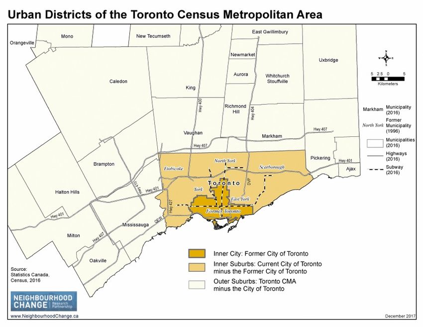
26                                     Richard White

                                 _____________________

 Fig 1 (courtesy of Neighbourhood Change)

   Notwithstanding the wheat fields and canoes still found in much of its national
imagery, Canada is a predominantly urban nation and has long been recognized as
such by anyone who gives the matter even a modicum of thought. Indeed, the
census of Canada classifies over 80% of the country’s population as urban. But the
census also reveals another perhaps less widely considered fact – a large proportion
of that 80%, probably at least half, resides in suburbs not cities. Distinguishing be-
tween city and suburb is no straightforward task, so exact proportions are elusive,
but ‘at least half’ seems a reasonable estimate (Turcotte, 2008; Canada, 2001). In
Canada overall 48% of the population of metropolitan areas lives in neighbour-
hoods classed as low-density, a good proxy for suburbs. The City of Toronto, Cana-
da’s most populous city, is nearly on that average, at 47%; Montreal is lower (34%)
and Calgary higher (67%). Looked at another way, 52% of Canada’s metropolitan
population lives over 10 kms from a city centre; Toronto’s proportion, with its exten-
sive suburban hinterland, is far higher at 76%. That is to say understanding Canadi-
an cities requires some understanding of Canadian suburbs.
   This essay offers a contribution to this by exploring the planning ideas that
shaped Toronto’s “inner suburbs”, a suburban area built between about 1950 and
1970 that is now generally considered a distinct, identifiable part of Toronto. (Fig 1)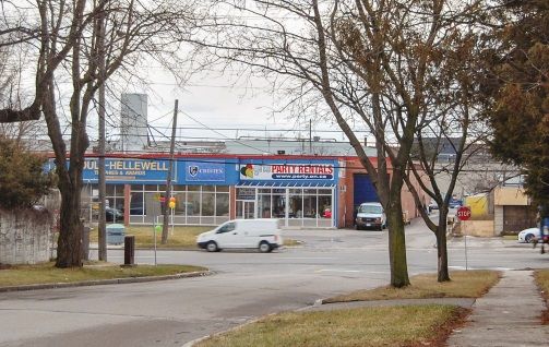
Toronto’s Inner Suburbs Through the Lens of Planning History                    27

It is premised not on the idea that these suburbs are typical, or representative of
Canadian suburbs generally – although there is evidence of their planning princi-
ples being applied in western Canada (Taylor 2010) – but primarily on the belief that
as home to nearly two million people in Canada’s largest city these suburbs are, at
the very least, a significant part of Canadian urban life. Interestingly, however, they
are not part of the city’s popular image, even the city’s own cognoscenti paid them
little attention until recently, and the famous urbanist Jane Jacobs, despite spend-
ing nearly forty years in Toronto, paid them no heed whatsoever. Yet they are a fas-
cinating urban form: no longer new but not yet old, peripheral at one time but now
woven into an extensive urban carpet, and seemingly based more on the older
urban function of production than the newer one of consumption. Moreover by
virtue of their extent and substantial population they are diverse in built form, eco-
nomic activity, and ethnic make-up, and as such bear almost no resemblance to the
archetypical white, middle-class North American ‘suburb’ – providing further evi-
dence, if it is needed, of the uselessness of that worn out archetype (Relph, 2014,
Chapter 5; Fishman, 1988). How and why they came to have the form they have
might be considered significant on its own.
   But in recent years they have begun receiving attention for other reasons. Lacking
the charm and cachet of the pre-automobile inner city, the larger houses of later
suburbs, and the low prices of the distant urban fringe, the inner suburbs are rarely
found on lists of where to live in Toronto. In fact the lists they often do appear on are
of the city’s disadvantaged, underserviced districts. Some years ago the academic
housing analyst David Hulchanski, after a careful analysis of census data, confirmed
that Toronto’s inner suburbs, largely middle-class in their first generation, had
evolved in the last forty-some years into predominantly low-income areas (Hulchan-
ski 2010). This finding raised considerable alarm. It prompted the City of Toronto to
consider new investments and social programs for certain inner-suburb neighbour-
hoods, and served as the take-off point for a comprehensive new program of re-
search by Hulchanski and several academic colleagues (Neighbourhood Change;
Parlette 2012; Cowen/Parlette 2011).2 Before long the picture of the inner suburbs
as sites of disadvantage had become firmly entrenched in the local discourse; a
widely-read commercial magazine described them as “spiralling into poverty”, and
noted that certain inner-suburb neighbourhood names now evoke images of
“crumbling postwar apartment blocks, underfunded schools or gang warfare” (Ful-
ford 2015; Burale 2015).3

2   The City first designated a group of “priority investment neighbourhoods” and, later, a slightly
    different group of “neighbourhood improvement areas”; details of both are publicly accessible
    on the City of Toronto website.
3   Fulford’s piece introduced a series of residents’ profiles entitled “Toronto is Failing Me”; this
    characterization was immediately challenged by one of the profiled residents, as reported in
    Burale’s blog post.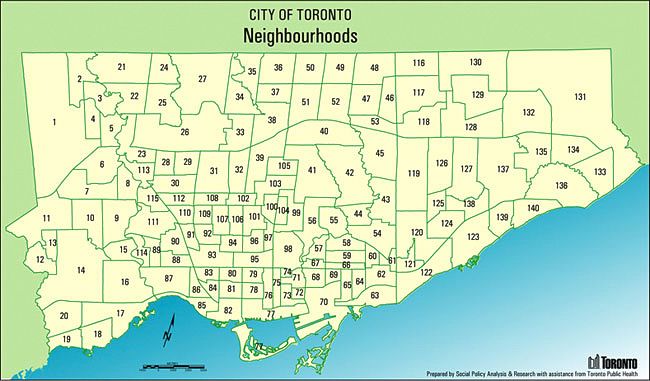
28                                             Richard White

  Heartening as it is to see good empirical research shaping both public discourse
and new social programs, this now widely-accepted picture does have some miss-
ing pieces. One is what caused it all. Analysts generally connect it to the social polar-
ization brought about by the ascendancy of neo-liberalism, which may be so, but
the mechanism by which neo-liberal policies actually caused incomes to decline in
these suburbs is not usually identified (Parlette 2012, is an exception).4 Moreover,
declining incomes in specific areas is not quite the same thing as growing overall
income disparity; low income people might simply be remaining in or migrating to
certain neighbourhoods, for any number of reasons, thus ‘lowering’ aggregate
neighbourhood incomes. The matter warrants further investigation. Another miss-
ing piece is historical perspective. The data used in Hulchanski’s study go back to
1970 – this is fundamental to the findings – but since most of the inner suburbs
were built before 1970 the picture might benefit from a longer timeline that in-
cludes their genesis.

    Fig 2: Map from Hulchanski, The Three Cities, identifying the affluent
    inner city (light grey), the shrinking middle-class suburban areas
    (white), and the lower-income inner suburbs (dark grey). (courtesy
    of Neighbourhood Change)

  The current study makes no effort to challenge the observation that average in-
comes in nearly all of Toronto’s inner-suburb census tracts are now lower than the
average income for the metropolitan area overall (Fig 2) (Hulchanski 2010, Map 3).
In fact it has been carried out with this social reality in mind. It simply explores to

4     Parlette’s dissertation, to this liberal-empirical historian, seems overly-influenced by non-
      Toronto research and rather tendentious in its analysis.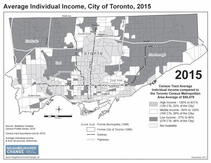
Toronto’s Inner Suburbs Through the Lens of Planning History        29

what extent the planning and building of these suburbs, all of which occurred be-
fore 1970, might have contributed to that reality. Nor does it challenge the widely
accepted notion that neo-liberalism is causing greater social inequality – although it
does, admittedly, start from the premise that we do not fully understand the link
between advancing neo-liberalism and declining incomes in Toronto’s inner sub-
urbs, and that other factors are worth considering. It seeks, all told, to add to our
understanding rather than to refute observations and explanations put forward by
others.

 Fig 3: The thirteen municipalities of Metropolitan Toronto, as created by the Gov-
 ernment of Ontario, effective 1 January 1954, showing their original incorporation
 dates. (White, Planning Toronto, Fig. 2.3)

  Toronto’s inner suburbs are examined here through the lens of planning history.
They make a fascinating case study for the planning historian: their creation was
guided by a set of planning principles, some common at the time and some not,
explicitly laid out in major planning reports, and their original form has been so
minimally disturbed by renovation and rebuilding that these principles are clearly
evident in the landscape today. Identifying and explaining these planning ideas,
and showing them having been applied, makes up the main part of this essay. But
planning history can contribute to the bigger picture too, and with concerns over
the state of Toronto’s inner suburbs so prevalent, locally at least, it seemed appro-
priate, and desirable, to move on to consider any possible connection between the
planning and the declining incomes of these areas. The paper thus concludes with
some speculative analysis of this matter.

  Creating the Inner Suburbs
  The part of Toronto now considered the inner suburbs was built in a single gener-
ation from about 1950 to 1970. Toronto and its environs had changed very little in
30                                          Richard White

the generation prior to that, urban growth having been curtailed first by the De-
pression and then by the war (Lemon 1985). The city boundary had been static even
longer. Although Toronto had grown rapidly in the 1920s, spilling over its municipal
boundary, city council had refused to annex any new territory, largely for reasons of
fiscal prudence, so the boundary stayed put and this peripheral growth, forced to
remain outside the city, organized itself into separate small municipalities. When the
postwar boom began taking hold in the late 1940s, and urbanization of the hinter-
land picked up, Toronto was surrounded by several small municipalities that, al-
though functionally part of the city, were politically and administratively independ-
ent. There was no formal body to control or even co-ordinate the growing urban
region – not an efficient or a desirable arrangement.
   The solution was Metropolitan Toronto, a federated municipality created by the
Province of Ontario in 1954 by partially amalgamating Toronto with its surrounding
municipalities (Rose 1972; Frisken 2007). It was only partial in the sense that the
thirteen municipalities affected, including Toronto itself, all continued to exist even
though they were joined together into a new over-arching metropolitan municipali-
ty. (Fig 3) Municipal responsibilities were divided between the two levels of gov-
ernment – some were assigned to one of the two levels and others were shared
between the two – according to a scheme set out in the provincial Metropolitan
Toronto Act (Ontario 1953).
   Metropolitan Toronto included not just the built-up towns and villages outside
Toronto’s municipal boundary but also three adjacent rural townships in which
future large-scale urbanization was expected. The expectation was fulfilled. In the
first decade of Metropolitan Toronto’s existence, 71K new single-family homes were
built in these until-then rural areas, and in the twenty years from 1951 to 1971 their
population increased from 50K to 500K (MTPB 1970; MTPB 1963a). This rapid devel-
opment, which astounded and unsettled many who witnessed it, created Toronto’s
inner suburbs.5

     Planning the Inner Suburbs
  Planning was one of the responsibilities the two levels of municipal government
shared. Metropolitan Toronto planners would plan metropolitan-wide infrastructure
and services, and broad-brush land use, while municipal planners would plan local
roads and services and site-specific land use. This dual responsibility worked well for
the city of Toronto, which already had a planning department, but less well for the
smaller municipalities that lacked, and were not always inclined to establish, plan-
ning operations. Provincial law required all municipalities to appoint planning

5     The amalgamation begun in 1954 was completed in 1998 when the federated municipality of
      Metropolitan Toronto became the unitary City of Toronto, fully dissolving the individual munic-
      ipalities that had been retained in 1954.
Toronto’s Inner Suburbs Through the Lens of Planning History              31

boards and begin developing official plans, but not all did, and even when they did
their boards were not always effective.
   The new metropolitan city, however, took its planning responsibility seriously
(White 2016, Chapter 2). Soon after Metro, as it was called, was formed it hired sev-
eral professional planners who then engaged staff to develop an official plan. It took
several years, but in 1959 the planners completed a draft metropolitan plan and
presented it to council for approval (MTPB 1959). This plan was not and in fact never
would be approved, for various reasons, yet it might as well have been because its
planning principles served as an unofficial guide for the urbanization of the metro-
politan area, especially for the inner suburbs considered here.
   The first, and most fundamental, planning principle was that there would be no
‘satellite towns’ – meaning new, master-planned towns built from scratch on rural
land well away from the existing city. Satellite towns (also called New Towns) were
the planning orthodoxy of the postwar years, but Metropolitan Toronto would not
have them; it would grow simply by expanding its existing urban area. Growth
would not be uncontrolled. Urbanization would be permitted only on land desig-
nated for that purpose, and the designated urban area would be expanded only as
needed. But unlike, say, postwar London, England, growth of which was scattered
around the city’s hinterland in designated New Towns, Metropolitan Toronto would
have what was often called a ‘contiguous’ urban area. The big city would just grow
bigger (Fig 4).

 Fig 4: The Metropolitan Toronto Planning Board’s proposed form for the urban region –
 existing urban area in solid grey and projected future urban area, all of it attached to
 existing urban land, in diagonal hatching. (White, Planning Toronto, Fig. 1.23)
32                                  Richard White

   There are two reasons for this unusual policy. One is Hans Blumenfeld, an aging
(b. 1892) but still vital German-trained architect/planner who, after a long, varied
international career, found himself working for the Metropolitan Toronto Planning
Board in 1955 as one of its senior planners. Some years earlier Blumenfeld, while
working in the United States, had concluded from his extensive experience that
new towns were not an effective way to accommodate urban expansion. Appealing
as they were to those seeking to avoid the problems of big-city congestion, they
simply did not work; “growth by accretion will remain the rule, and growth by pro-
creation the exception” (Blumenfeld 1967, 38) he asserted in a 1948 article. Blumen-
feld brought this idea with him to Toronto, and apparently without much opposi-
tion made it a guiding principle of the metropolitan plan.
   The second reason for avoiding satellite towns is that urban development would
have what the planners called "lake-based" piped services, an important planning
principle of its own. Municipal water would be drawn from Lake Ontario, treated at a
lakefront treatment plant, and piped out to all corners of the urban area; neither
groundwater (from wells) nor surface water (from rivers and streams) would be used
for municipal supply, and the old public systems that did were to be shut down.
Similarly, all water-borne sewage produced in the metropolitan area would be col-
lected in local sewers and piped down, untreated, to large lakefront plants where it
would be treated and dispersed far out in the lake; neither septic tanks nor local
sewage plants would be acceptable for servicing new urban development (contrast
with Rome 2001). A closed system such as this, with lake water piped out from the
lake and suburban sewage piped back, made distant satellite towns illogical. The
foundation of this policy, one might note, was the provincial public health authority
which had concluded, after studying the region in the late 1940s, that large scale
urban development that used only local treatment plants, or septic tanks, for sew-
age treatment would debase the local groundwater so badly that it would threaten
public health (White 2016, 60-61; Gore/Storrie 1949).
   A corollary of these two principles – that development must be confined to a con-
tiguous urban area and permitted only when lake-based piped services are in place
– is that in a rapidly growing area in which private enterprise is building all the
housing, which Metropolitan Toronto was, public authorities have an obligation to
install those piped services as quickly as possible. And they did. The metropolitan
government could not build the entire new system in an instant, but it strove to do
so as rapidly as its finances and management capacity allowed.
   Another important metropolitan planning principle was that residential densities
should be kept relatively high throughout the metropolitan area, an idea that com-
plemented their policy of setting and holding a strict urban boundary. It applied to
both the inner city, where, with some minor exceptions, existing densities would be
maintained – the planners neither envisioned nor desired a de-populated inner city
– and to the newly urbanizing suburban areas, where development would be at
Toronto’s Inner Suburbs Through the Lens of Planning History                33

densities higher than typical North American suburbs. The latter meant new sub-
urbs would include townhouses and apartment buildings along with conventional
suburban homes. Density was deemed desirable not only because it would make
services and businesses viable, but also because, since high-density rental housing
generally attracts lower income people, it would promote social mixing, which the
planners wanted (White 2016, 127-31; Comay 1983). It is important to note, howev-
er, that this multi-unit housing would be created by private developers, not by gov-
ernment; the metropolitan plan encouraged its creation, but neither the planners
nor any other public agency would build it (Ontario Housing Corporation, 1984).6
   In the realm of transportation, Metropolitan Toronto planners called for a "bal-
anced" system, meaning a balance between public (i.e. transit) and private (i.e.
cars/roads) modes of travel, but also, for the latter, a balance between expressways
and ‘arterial’ roads – six-lane roads, with minimal residential or commercial devel-
opment along them, intended to carry heavy traffic, but built on-grade (neither
sunken nor raised) and thus with traffic lights at major intersections. Two east-west
expressways were planned for the eastern half of the metropolitan city: a major
inter-city expressway, then being built across the metropolitan area by the Province
of Ontario, and an eastward extension of the lakeshore expressway that had been
completed from the west only as far as the downtown. Arterial roads were consid-
ered sufficient for the newly-built suburban areas, reflecting the planners’ wish to
provide mobility for cars, trucks, and public-transit buses without the disruption and
expense of expressways. The priority given to public transit might seem surprising
for a postwar North American city, but the city of Toronto’s existing transit system
was being heavily used, and the commission operating it was committed to ex-
panding services across the entire metropolitan area.
   One less widely recognized but important planning principle was that substantial
land should be designated for industry along railway corridors and major highways
throughout new suburban areas. There were two reasons for this. One is that it
would provide the local municipalities with a plentiful property tax base. Property
tax revenue was shared among the municipalities of Metropolitan Toronto to a
degree, but having a good local tax-base was still advantageous. The other more
planning-related reason is that it would reduce the need for employees to travel
long distances to work and thus lessen the demand for roads and buses.
   One final metropolitan planning principle was to use the river valleys, called "ra-
vines" locally, as public parkland; they would be left in a fairly natural state, with
minimal landscaping and construction, but they would be made publicly accessible
by roads and public transit. This too was a rather novel idea. North American urban
parks in the early postwar years tended to be more for recreation and active games,
with playing fields and open-air performance venues, than for nature (Cranz 1982,

6   Some public housing was also built in the suburbs in these years, and some privately-built,
    multi-unit, suburban housing was later purchased by public housing authorities.
34 Richard White 103-26), but the metropolitan planners fixed on the idea of leaving them largely undeveloped, fully aware, it might be said, of the expense they were avoiding. Metropolitan planning prescribed broad-brush land use, not detailed land use for individual parcels of land. This finer level of detail was the domain of local municipal planners. But with planning not yet well developed in the local municipalities, espe- cially in the three large municipalities of Etobicoke, North York, and Scarborough that, as rural townships, had had little need to plan, they were in no position to undertake detailed land-use planning. Scarborough, although resistant at first, did engage a permanent Planning Commissioner soon after Metropolitan Toronto was formed, and developed an Official Plan – though its impact is hard to determine. So the main force that shaped the internal design of the inner suburbs was not local municipal planners, or any public authority, but the private development firms that built the suburbs and the planning consultants they hired. For the most part, these firms would assemble tracts of farmland in areas designated for development, en- gage planners to lay out the streets and lots and engineers to devise the neigh- bourhood infrastructure, seek and usually obtain approvals for their scheme from government authorities, and then either build houses themselves or, more com- monly, sell off lots to smaller-scale builders who would build and sell the housing (White 2016, 91-113). The chief guiding principle for the consultants planning these suburbs was the “neighbourhood unit”, a concept devised by the American social planner Clarence Perry for the 1929 Regional Plan of New York that by the 1950s had been interna- tionally adopted (Perry 1929; Whittick 1974, 714-16; Silver 1985). Perry believed that a new urban area should foster a sense of community among its residents and that this could best be achieved by emulating traditional neighbourhoods: a population of about 6,000, a public school at the centre alongside other community buildings and open space, a mix of housing types and sizes (including rental apartments), and commercial shops and services that, following the planning principle of separating land uses, were to be on the periphery of the neighbourhood outside the residential areas. Mostly in the interests of safety, Perry also favoured keeping through traffic outside the neighbourhood on wide, large-capacity roadways and having streets inside the neighbourhood, apart from one or two access roads, only for local traffic. By the time Toronto’s postwar inner suburbs were being designed, Perry’s concept had been enhanced by several additional design novelties, most of them rooted in the celebrated layout of Radburn, New Jersey, which was conceived about the same time as Perry’s neighbourhood unit, and the even better known American greenbelt towns devised under Roosevelt’s New Deal administration in the 1930s (Hall 2002, 132-36; Ward 2002, 117-19). Chief among these were curving residential streets – now such a common marker of suburbia – that looped back to where they began so as to be of no use for anything but local traffic, and public walkways behind and between private yards to facilitate access to public spaces. Both these design ele- ments were intended to keep pedestrians safe from motor vehicles.
Toronto’s Inner Suburbs Through the Lens of Planning History 35
Evidence in the Landscape
Such are the planning ideas, metropolitan and local, that shaped Toronto’s inner
suburbs. They were widely applied, and are literally everywhere in Toronto’s inner
suburban landscape. For this study, eleven suburban neighbourhoods were exam-
ined, at various levels of detail, across the eastern half of the city, most of them in
what is still called Scarborough despite that municipality having been dissolved into
the single City of Toronto in 1998. They offer plentiful evidence (City of Toronto,
Neighbourhood Profiles).7 (Fig 5)
Fig 5: Neighbourhoods observed for this study: Clairlea (120), Oakridge (121), Victoria Village (43),
Woburn (137), Knob Hill (part of 127), Midland Park (part of 126), Bridlewood (part of 117), Steeles
(116), Milliken (130), Ionview (125), Kennedy Park (124) (City of Toronto, Neighbourhood Profiles)
First, just by looking at a map one can discern several of the metropolitan plan-
ning ideas (Fig 6). The principle of lake-based piped services is, of course, not appar-
ent since evidence of it is buried underground; nor, in a sense, can one see the ab-
sence of satellite towns insofar as the absence of anything is usually hard to see. But
the principle of contiguous urban development that followed from those two is
certainly evident in the urbanized areas having no open spaces between them; one
neighbourhood runs immediately up against the next. What divides the neighbour-
hoods are the arterial roads, another key element of the metropolitan plan. Natural
7 Neighbourhood names and boundaries are not official, and often vary. Mostly for convenience,
fieldwork was done largely in Scarborough, an early adopter of planning; these metropolitan
planning principles might not have been as widely applied in other parts of Metropolitan To-
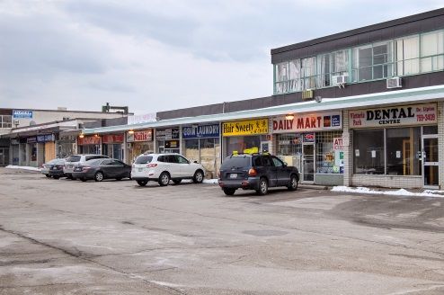
ronto.36 Richard White ravine parks, running alongside or in some cases through the residential neigh- bourhoods, are visible, as are the smaller, man-made parks amid the residential neighbourhoods. The style of street layout shows as well: looping residential streets and longer, curving streets to convey cars and buses into and through the neigh- bourhood. Fig 6: Google map of central Scarborough Fig 7: Young girls’ after-school slow-pitch soft- Fig 8: Small local shopping strip, barely ball game, schoolyard/park in central core of holding on, Victoria Park Avenue, north of Milliken neighbourhood, McCowan Road south Eglinton Avenue, Victoria Village neighbour- of Steeles Avenue. (Photo by author) hood. (Photo by author) Driving and walking about reveals much more. Residential areas are clearly sepa- rate from the arterial roads bordering the neighbourhoods; one senses the roads, especially their noise, but few vehicles enter. Neighbourhoods are islands of resi- dential land use, as they were supposed to be, free not only of vehicles but also of
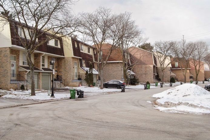
Toronto’s Inner Suburbs Through the Lens of Planning History         37

commercial activities of any sort. One sees plenty of multi-family housing. Every one
of the neighbourhoods examined has some, usually townhouses and high-rise
apartment buildings; whole complexes of the former were usually part of the origi-
nal neighbourhood design, while one or two of the latter were generally built a few
years later along the peripheral arterial roads on land designated for this purpose.
Every neighbourhood has a public school, or two if it is large, usually backing onto
or somehow connected to public parkland, as Perry’s concept prescribed. Churches
are also common, especially in the older, pre-1960, neighbourhoods. (The changing
role of Christian churches in suburban neighbourhoods, reflecting both the sudden
decline in religious observance among the established middle classes and the influx
of non-European Christian sects, warrants its own study.)
   The neighbourhoods are well endowed with public open space. Many have
stretches of ravine parkland along their borders, usually with multiple pedestrian
access points. All have fully-developed neighbourhood parks with a playground and
often a playing field (Fig 7), and these parks also have several access points. Some
neighbourhoods have public walkways between properties providing pedestrian
access to various places and services; not all are well located, but their placement
might have made more sense when the neighbourhood was initially built.
   The neighbourhoods also, invariably, have commercial strips or malls along their
edges, again consistent, basically, with the neighbourhood unit concept though
most have evolved and do not function quite as the planning concept envisioned.
Small shopping strips now seem to serve a drive-in rather than a walk-in clientele,
although they do often include ethnic restaurants and grocery stores that may have
local patronage (Fig 8); some of these strips have failed, however, and their land is
now slated for residential development – demand for housing being, apparently,
greater than demand for local shopping. Most larger shopping malls have survived,
but clearly, considering the size of their parking lots, they have not done so by serv-
ing a local clientele.
   Finally one cannot help but notice the proximity of industrial plants, again as
planned. Toronto has experienced some de-industrialization in recent decades, and
as a result some of these industrial sites, and even some of the industrial buildings
themselves, are being used for commercial storage, exercise gyms, religious institu-
tions, and large-scale retail rather than for industry. As well, some areas have been
cleared of industrial buildings and used instead for what is termed ‘brownfield’ resi-
dential development, although proximity to roads and railway lines limits this
somewhat. Many industrial buildings and sites, however, still remain industrial.

  The Legacy of Planning
  There can be no doubt that Toronto’s inner suburbs were planned. Virtually every
land use, every street, and every amenity is where it is because a plan prescribed it
thus, something possible only when urban development occurs de novo, as was the
case here. Not all the buildings in the inner suburbs were planned to be as they are –
38                                   Richard White

an important distinction. Planners prescribed the size and configuration of individ-
ual lots, and which land uses would go where, and in doing so influenced what sort
of buildings were erected. However, a building’s actual design, and how it used its
site, was in the hands of the landowner or builder who built it, along with, in some
cases, architects hired by them. But the overall design and function of the suburbs
was planned.
   What then might be the connection between their planning and their declining
average incomes? Touring through the inner suburbs today they do indeed, as
might be expected, show signs of low income; one is struck immediately by the
poorly-maintained houses, suggesting houses that may not be owner-occupied or
an owner/occupier who lacks the funds for regular maintenance. Even more striking
is the rarity of substantial rebuilds or stylish upgrades – such a contrast to the old
inner city where it seems almost every other house has had substantial capital in-
vested in it. Many streets seem almost as-built, unchanged in sixty years. At the
same time, however, by no means do the neighbourhoods feel abandoned, or even
under-populated. Unoccupied houses are rare. Many residential areas are alive with
care-givers and children when school lets out. People are clearly making do. Lan-
guage like "spiralling into poverty" and "crumbling postwar apartment buildings"
seems overly alarmist, verging on the anti-slum panics of years past, yet there is,
unmistakably, an absence of affluence. Homeowners with the means and inclination
to renovate – the notorious gentrifiers who have overrun the pre-1914 city – are
nowhere to be seen. To some this might not be a bad thing, but whether good or
bad the absence of affluent in-migrants, so visible in the landscape, so anomalous
for Toronto, does begin to look like one of the causes of declining aggregate in-
comes relative to the rest of the city. How significant a cause, one cannot say; falling
incomes among those who remain, whether from individuals aging or from well-
paid jobs disappearing, undoubtedly contributes as well. But accepting it as a factor
of at least some significance allows the question atop this paragraph to be re-
worked into one that is more answerable, or at least about which one can speculate:
what role has planning played in making the inner suburbs unappealing to Toron-
to’s gentrifiers?
   It must be said, to begin, that some of the declining appeal of the inner suburbs
can be attributed to the general turn against ‘the suburbs’ – any suburbs – by the
fashionable middle and upper classes after about 1970, a cultural shift of considera-
ble importance in the evolution of urban form. In Toronto this general drift was
likely accentuated by the style of early postwar mass-market housing; with designs
rooted largely in the austere prewar world, 1950s housing surely had little appeal to
the increasingly affluent, cosmopolitan baby-boomers of the 1970s (Fig 9). Early
efforts to accommodate the car, which even in the 1950s Toronto’s homebuyers
expected a house to do, led to some quite awkward designs. Yet so great was the
demand for housing in the early postwar years that literally thousands upon thou-
sands such houses were built in Metropolitan Toronto, with a degree of uniformity
Toronto’s Inner Suburbs Through the Lens of Planning History 39
made necessary, one presumes, by the rapidity of their construction. So scarcely a
generation after they were built these houses were not what people of means and
style wanted to live in, or among. This aspect of the inner suburbs resulted, essen-
tially, from their having been built with great urgency by a massive investment,
public and private, in a short period of time amid particular circumstances, bringing
to mind Jane Jacobs’s fascinating insight that “cataclysmic money” so often yields
inferior urban form. (Jacobs 1992, Chapter 16). Planning had nothing to do with this.
Planning has produced some appealing features. Foremost might be the careful-
ly-sited and usually walkable neighbourhood schools, a foundation of neighbour-
hood planning that families with children no doubt find attractive. Perry’s idea of
the school serving as the basis for a community was, in these suburbs at least, rather
fanciful on account of the many childless households and the substantial turnover
of population. Changes in the population of school-age children have made some
schools under-used and others over-used, creating problems for school board ad-
ministrators, but the neighbourhood schools themselves were and still are a desira-
ble asset. Moreover, contrary to recent rhetoric these schools are as well-funded as
those anywhere else in the city, not because of planning but because the metropoli-
tan government made it a policy to equalize public education revenues. Municipal
jurisdictions with low property tax revenues do not have lesser-funded public
schools.8
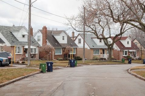
Fig 9: Houses in Clairlea, as built in the early Fig 10: Looking west to former industrial land
1950s. (Photo by author) across Midland Avenue, south of Ellesmere,
Midland Park neighbourhood. (Photo by author)
Some might also consider the inner suburbs’ plentiful open space to be a desira-
ble feature. Neighbourhood parks have come under criticism for being little-used
and larger than necessary,9 and indeed the designated dog zones now seem to be
8 Schools in non-affluent areas are proving unable to raise as much money in local fund-raising
drives, a point of growing significance.
9 Green Space is negatively weighted by the City of Toronto in its quantitative assessment of
inner suburb neighbourhoods, apparently because it produces low residential density – City of
Toronto, 2014.40 Richard White the only well used parts of many large parks. Still, some residents likely enjoy them. One wonders, as well, if the principle of the quiet residential island free of through traffic and commercial activity might appeal to some. Planners now criticize this too, especially the strict prohibition of commercial activity from residential areas, and in many new suburban developments planners have brought back the old rectilinear grid of through streets – though to promote mixed uses rather than through traffic. Walking along these calm, curved streets today one wonders why the principle that spawned them has fallen so totally out of favour, and whether residents oppose it as much as planners – who likely live elsewhere – do. All told, these features may have been deterrents to some potential in-migrants but magnets to others. The planning principle of urban contiguity (absence of satellite towns) and the related principle of building at moderate density might also be judged as having left a mixed legacy. Taken together, the two have produced some desirable features. Plentiful commercial service strips is one. Many of these strips have failed, as noted, but many do survive – often housing well-regarded but low-priced ethnic food shops and restaurants – and although their relation to their immediate neighbour- hood may be at odds with their original purpose they do provide useful local ser- vices. Another is viable public transit, an aspect of Toronto’s inner suburbs consid- ered both unusual, comparatively speaking, and commendable. Had these suburbs been built in the form of satellite towns, the growth option Metropolitan Toronto rejected, they could never have been served by regular public transit – unless all residents worked in the same central location, which would not have happened. Toronto has among the highest rates of transit use in North America and the plan- ning principles of the inner suburbs have helped make it so (van Susteren 2007; Sorensen/Hess 2007). It is true that transit service in the inner suburbs could be much better: existing subway lines barely reach the inner suburbs, densities are not sufficient to support all-day frequent service, and access to transit is difficult in many places. All this may have been, and may still be, a deterrent to affluent in- migrants. That is to say planning principles have allowed viable public transit in the inner suburbs, but perhaps not enough of it to satisfy those who can afford to live in the old, better-served city. It must also be acknowledged that the planners’ desire for density has produced features that some likely find unappealing: major road allowances are rather slim, roads and industries are close to houses, and open space between neighbourhoods is minimal, resulting in an overall compactness that can feel rather unrelenting and, maybe for some, un-suburban. The fact is that these inner suburbs – not as mixed and walkable as old urban neighbourhoods but not as open and spacious as con- ventional suburbs – are something of an urban hybrid, and as often with such things, many will prefer one of the recognizable progenitors to the ambiguous blending of the two. The idea of employing a grid of arterial roads to service this entire urban area – a key transportation planning principle – may be a problem of its own. Busy arterial
Toronto’s Inner Suburbs Through the Lens of Planning History                   41

roads are never far away from anywhere. And while it is true that their continuous
heavy traffic is the flip-side of traffic-free residential areas, they produce noise, de-
grade the air, and, when one has to cross them to reach a grocery store or bus stop,
can threaten life and limb. Surely they are carrying far more traffic than ever envi-
sioned, since the number of people and amount of economic activity out beyond
them, and thus dependent on them for the movement of people and goods, has
probably doubled or tripled in the sixty years since they were built, making them a
greater hazard now than when first envisioned as an efficient, low-cost way to ser-
vice a new suburban area. Here may be a case of a planning idea that although apt
when first applied was not well suited to changes that ensued. The alternative
would have been fewer but larger roadways, which is to say expressways; they too
degrade the environment, although perhaps in a more localized, less pervasive,
manner.
   The proximity of industrial to residential land may also be a problem of its own.
Dispersing industry throughout the metropolitan area seemed like a good idea
because it promised to reduce the distances industrial workers had to travel for
employment, but one doubts the principle actually provided such benefits. Resi-
dents of the inner suburbs did not all work in industry, and even for those who
worked in a local plant it is hard to imagine that having their plant just down the
street would be desirable. This is just as true today; even where party supply outlets
have replaced industrial plants, the proximity of these industrial-looking lands has a
way of debasing adjacent residential neighbourhoods (Fig 10).

                                                                    Fig 11: Townhouse
                                                                    complex in Woburn
                                                                    neighbourhood, laid out
                                                                    and built as part of the
                                                                    original neighbourhood
                                                                    design, early 1960s.
                                                                    (Photo by author)

   The planning idea with probably the greatest impact on the inner suburbs is the
notion that residential areas should include multi-unit housing, another manifesta-
tion of the desire for density. This housing takes two main forms: townhouses, some
intended for rental and some for owner/occupation, and rental apartments, both
high-rise and low-rise (Fig 11). Several neighbourhoods also have stretches of ‘semi-
42 Richard White
detached’ houses,10 usually on the streets closest to industrial employment areas. It
is hard to say what impact this has had on neighbourhood appeal. Considering the
antipathy that better-off inner-city property owners have towards apartment build-
ings one might think that higher-income people would be deterred by their pres-
ence. This is not readily apparent. What little upper-middle-class housing exists in
the neighbourhoods observed for this study seems as likely to be in the vicinity of
multi-unit housing as not, which is no surprise since the latter is almost everywhere.
Yet this planning idea surely has contributed to the inner suburbs’ lower than av-
erage incomes in another, more direct way – it has allowed, in fact encouraged,
lower-income people to live in the inner suburbs. Through the lens of planning
history the presence of lower-income people in Toronto’s inner suburbs is, essential-
ly, a successful implementation of the planners’ goal of socio-economic diversity.
And it begins to seem possible that, since the inner suburbs were devised from the
start to include lower-income residents, the demographic phenomenon of the last
two generations could actually be the absence, or the departure, of higher-income
residents.
Presenting this catalogue of planning ideas that may have lessened the appeal of
the inner suburbs to affluent in-migrants is not meant to suggest that social prob-
lems in the inner suburbs can, or should, be remedied by somehow making these
neighbourhoods more appealing to gentrifiers. Quite the contrary. There is, of
course, a similarity between the features just catalogued and the very real short-
comings that current residents of the inner suburbs encounter in their day to day
lives and often strive to remedy through their own community actions. Indeed, why
would there not be an overlap between qualities that discourage higher-income
people from moving in and qualities that burden lower-income people already
there? So perhaps these deterrents should be remedied – insofar as they can be –
for the sake of those who live with them. Yet a curious irony is brought to light by
this overlap: the very features that burden the lower-income residents of the inner
suburbs may also be protecting the inner suburbs from gentrification and the rising
cost of living that would almost certainly ensue.
Immigration and Planning
One final aspect of the inner suburbs’ planning to address briefly is their connec-
tion to immigration. Like all major North American cities, Toronto has been a city of
immigrants for as long as it has existed, the proportion of immigrants (defined
simply as non-Canadian-born) ranging around 40% throughout the twentieth cen-
tury (Lemon 1985, 196, Table VII). The proportion is somewhat higher now, ap-
proaching 50%. The inner suburbs have their share, but not an outsize share. In
1971, the inner suburbs had 52% of the urban region’s population and 51% of its
10 The common local term, British in origin, for side-by-side duplexes, of which Toronto has tens of
thousands.Toronto’s Inner Suburbs Through the Lens of Planning History 43 immigrants; in 2016 they had 33% of the region’s population (their population was still increasing, but growth in the outer suburbs was diminishing their share) and 37% of its immigrants, so immigrants are now slightly over-represented in the inner suburbs, but not by much (Canada, 1971 and 2016). It is the case, however, that several of Toronto’s neighbourhoods with the highest proportion of foreign-born are in the inner suburbs. The East York high-rise neigh- bourhood of Thorncliffe Park, with some 70% non-Canadian-born, is perhaps the best known (Saunders 2010, 311-23). But several neighbourhoods in north-eastern Scarborough show similar demographic profiles (City of Toronto, Neighbourhood Profiles). In Milliken and Agincourt, for example, some 75% of residents are non- Canadian-born, about one-third of which are newly-arrived (since 2001) immigrants, and some 65% of residents do not speak English at home – an obvious challenge for the local school teachers. So clearly the inner suburbs, at least some parts of them, are serving as an entry-point for immigrants to the city, another social reality of considerable significance. Interestingly, however, unlike Thorncliffe Park the two above-named heavily- immigrant Scarborough neighbourhoods, Milliken and Agincourt, are not among those identified by the City as needing “Neighbourhood Improvement”, a classifica- tion based on an amalgam of economic, social, and health measures (City of Toron- to, 2014). Evidently a high proportion of immigrants is not necessarily correlated with the declining incomes and social distress for which the inner suburbs are now well known. Also worth noting, these two neighbourhoods are not heavily stocked with high-rise apartment buildings (though they do have some, as well as more row houses and duplexes than the Toronto average). In fact 50% of the households in Milliken are single-family homes, well above the proportion in the city overall, so it would appear that high-rise apartments, though an important part of immigrant settlement in Toronto, are not the only form of housing used by immigrants. As for the role of planning in all this, having the inner suburbs function as an im- migrant entry point was not explicitly part of any plan, but the planners did see multi-unit suburban rental housing as potential homes for the immigrants – pri- marily European at that time – who were arriving in Toronto in large numbers while the inner suburbs were built (Jones 1963). So the current situation is neither entirely unexpected nor in any way contrary to plans. Conclusion The prime objective here has been to explore the planning ideas employed in creating Toronto’s inner suburbs and to consider whether and how these ideas shaped the inner suburbs of today. Clearly, based on what has been presented here, Toronto’s inner suburbs were planned, at both a metropolitan and a neighbourhood scale, and the planning principles employed did indeed shape the physical and, to a degree, social aspects of the inner suburbs. This needs to be said on account of a general, if not always explicitly expressed, sense among critics of suburbs that ‘sub-
44                                          Richard White

urbia’, as it is still often pejoratively labelled, was more an unintended consequence
than a desired outcome, and that the absence of planning is, in fact, why it has the
form it has. This study reveals just the opposite: Toronto’s inner suburbs were
planned, and their physical form is what its planners wanted. One might disapprove
of their urban form, but whatever shortcomings one sees in them are almost cer-
tainly the result of planning, not of its absence.
   Has planning contributed to the inner suburbs evolving into areas with lower
than average incomes? Using the proxy question of whether it contributed to mak-
ing the inner suburbs unattractive to affluent in-migrants, the answer is not defini-
tive. Some planning ideas may have lessened their appeal, such as placing indus-
tries close to residences, strictly separating uses, relying on arterial roads, and creat-
ing excessive local parkland; but others, such as neighbourhood public schools,
transit-supportive densities, local shopping options, and plentiful multi-unit hous-
ing, could well have done the opposite. But all these may be less important than the
planning idea of including at least some lower-cost rental housing in all residential
neighbourhoods; this, on its own, ensured the inner suburbs would include a signif-
icant number of lower-income residents.

Bibliography

Blumenfeld, Hans, 1967, “Alternative Solutions for Metropolitan Development”, in: Paul D. Spreiregen
      (ed.), The Modern Metropolis: Its Origins, Growth, Characteristics, and Planning, Cambridge, MA:
      MIT Press, (originally published 1948), 194-99.
Bousfield, John, interviews by author 28 February 2003, 20 March 2007, and 20 April 2009.
Burale, Idil, 2015, “We Need to Reframe How We Talk About Our City”, Spacing magazine, 27 January
      2015, accessed February 2017 at http://spacing.ca/toronto/2015/01/27/burale-need-reframe-
      talk-city/.
Canada, 2001, Statistics Canada, Table A.1 Distribution of the population, by type of neighbour-
      hood, at https://www.statcan.gc.ca/pub/11-008-x/2008001/t/10459/4097957-eng.htm, ac-
      cessed November 2017.
----, 1971 and 2016, Statistics Canada, Census Profile Series.
City of Toronto, 2014, “Neighbourhood Improvement Area Profiles”, accessed November 2017 at
      https://www.toronto.ca/city-government/data-research-maps/neighbourhoods-
      communities/nia-profiles/.
----, Neighbourhood Profiles, accessed 30 June 2017 at
      https://www1.toronto.ca/wps/portal/contentonly?vgnextoid=ae17962c8c3f0410VgnVCM1000
      0071d60f89RCRD.
----, Staff Report, 4 March 2014, “Toronto Strong Neighbourhoods Strategy 2020 – Recommended
      Neighbourhood Improvement Areas”, Neighbourhood Equity Index, Methodological Documen-
      tation, Table 3.
Comay, Eli, 1983, “Looking Backward: From Reality to Plan”, in: Conflict or Co-operation? The Toronto-
      Centred Region in the 1980s, Frances Frisken (ed.), Downsview ON: Faculty of Arts, York Universi-
      ty, 16-21.
Cowen, Deborah/Vanessa Parlette, n.d., Toronto Inner Suburbs: Investing in Social Infrastructure in
      Scarborough, Toronto: University of Toronto Cities Centre.
Toronto’s Inner Suburbs Through the Lens of Planning History 45
Cranz, Galen, 1982, The Politics of Park Design: A History of Urban Parks in America, Cambridge, MA:
MIT Press.
Fishman, 1988, “The Post-War American Siburb: A New Form, A New City”, in Daniel Schaffer,, ed.,
Two Centuries of American Planning. London, Mansell, 265-78.
Frisken, Frances, 2007, The Public Metropolis: The Political Dynamics of Urban Expansion in the Toronto
Region, 1924-2003, Toronto: Canadian Scholars’ Press.
Fulford, Sarah, 2015, “Why Toronto Needs to Talk About the Inner Suburbs”, Toronto Life, 12 January
2015, followed by a series of residents’ profiles under the title "Toronto is Failing Me"
http://torontolife.com/city/toronto-is-failing-me-why-toronto-needs-to-talk-about-the-inner-
suburbs/ (accessed 30 June 2017).
Gore/Storrie, 1949, “Toronto and York Planning Board Report on Water Supply and Sewage Disposal
for the City of Toronto”, unpublished report.
Hall, Peter, 2002, Cities of Tomorrow: An Intellectual History of Urban Planning and Design in the Twen-
tieth Century 3rd edition, Oxford: Blackwell.
Hulchanski, J. David, 2010, The Three Cities Within Toronto: Income Polarization Among Toronto’s
Neighbourhoods, 1970-2005, Toronto: University of Toronto Cities Centre
Jacobs, Jane, 1992, Death and Life of Great American Cities, New York: Vintage Books (originally pub-
lished 1961).
Jones, Murray, 1963, “Metropolitan Man: Some Economic and Social Aspects”, Plan Canada, 4. 1, 11-
23.
Lemon, James, 1985, Toronto Since 1918: An Illustrated History, Toronto: Lorimer.
Metropolitan Toronto Planning Board (MTPB), 1959, Official Plan of the Metropolitan Toronto Planning
Area, Toronto: Metropolitan Toronto Planning Department.
----, 1963a, Key Facts, Toronto: Metropolitan Toronto Planning Department.
----, 1963b, 10 Years of Progress: Metropolitan Toronto, 1953-1963, Toronto: Metropolitan Toronto
Planning Department.
----, 1970, Key Facts, Toronto: Metropolitan Toronto Planning Department.
Neighbourhood Change, a multi-year program of research and publication centred at the University
of Toronto, accessible at http://neighbourhoodchange.ca/.
Ontario, 1953, “Municipality of Metropolitan Toronto Act”, c.75, Statutes of Ontario.
Ontario Housing Corporation, 1984, Ontario Housing Corporation, 1964-1984, Government of Ontar-
io.
Parlette, Vanessa Marie, 2012, “On the Margins of Gentrification: The Production and Governance of
Suburban ‘Decline’ in Toronto’s Inner Suburbs”, Ph.D. Dissertation, Department of Geography,
University of Toronto.
Perry, Clarence Arthur, 1929, “The Neighbourhood Unit”, in Neighbourhood and Community Planning,
Vol. 7 of Regional Plan of New York and Its Environs, New York: Committee on Regional Plan of
New York and Its Environs, 22-132.
Rome, Adam, 2001, The Bulldozer in the Countryside: Suburban Sprawl and the Rise of American Envi-
ronmentalism, Cambridge, UK: Cambridge University Press.
Rose, Albert, 1972, Governing Metropolitan Toronto: A Social and Political Analysis, 1953-1971, Berke-
ley, CA: University of California Press.
Saunders, Doug, 2010, Arrival City: The Final Migration and Our Next World, Toronto: Alfred A. Knopf
Silver, Christopher, 1985, “Neighbourhood Planning in Historical Perspective”, American Planning
Association Journal, 51. 2, 161-74.
Sorensen, Andre/Paul Hess, 2007, “Metropolitan Indicators Poster”, Toronto: Neptis Foundation
http://www.neptis.org/publications/metropolitan-indicators-poster (accessed 30 June 2017).You can also read