TOWN OF DENNIS OPEN SPACE and RECREATION PLAN - 2020 UPDATE
←
→
Page content transcription
If your browser does not render page correctly, please read the page content below
2020 UPDATE

    TOWN OF DENNIS
    OPEN SPACE and RECREATION PLAN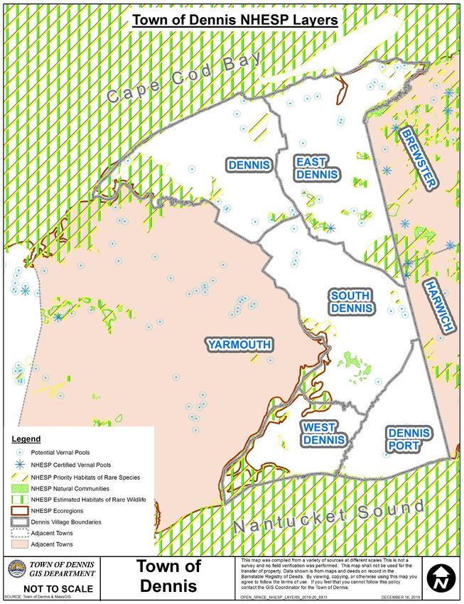
Table of Contents
Section 1. Plan Summary..................................................................................................................................4
Section 2. Introduction.....................................................................................................................................6
   A. Statement of Purpose .............................................................................................................................6
   B. Planning Process and Public Participation ...............................................................................................7
Section 3. Community Setting ..........................................................................................................................8
   A. Regional Context .....................................................................................................................................8
   B. History of the Community ................................................................................................................... 10
   C. Population Characteristics .................................................................................................................. 12
   D. Growth and Development Patterns .................................................................................................... 14
   E. Environmental Justice and Equity ......................................................................................................... 21
Section 4. Environmental Inventory and Analysis......................................................................................... 23
   A. Geology, Soils, and Topography .......................................................................................................... 23
   B. Landscape Character ........................................................................................................................... 28
   C. Water Based Resources ....................................................................................................................... 28
   D. Vegetation........................................................................................................................................... 41
   E. Fisheries and Wildlife ........................................................................................................................... 43
   F. Scenic Resources and Unique Features................................................................................................. 46
   G. Environmental Challenges .................................................................................................................... 51
Section 5. Inventory of Lands of Conservation and Recreation Interest ...................................................... 55
   A. Public Lands and Facilities..................................................................................................................... 55
   B. Private Open Space Lands and Facilities ............................................................................................... 56
   C. Recreational Facilities ........................................................................................................................... 58
   D. Recreational Programs ......................................................................................................................... 60
Section 6. Community Vision ........................................................................................................................ 67
   A. Description of Process.......................................................................................................................... 67
   B. Statement of Open Space and Recreation Goals ................................................................................ 67
   Section 7. Analysis of Needs ..................................................................................................................... 68
   A. Statewide Comprehensive Outdoor Recreation Plan (SCORP) Needs Assessment .............................. 68
   B. Summary of Resource Protection Needs and Resources .................................................................... 68
   C. Summary of Community Needs ........................................................................................................... 71
   D. Management Needs/Potential Change of Use .................................................................................... 74
   E. Waterways Needs ................................................................................................................................. 75
Section 8. Goals and Objectives .................................................................................................................... 77
Section 9. Five Year Action Plan .................................................................................................................... 80
                                                                             1
Section 10. Public Comments........................................................................................................................ 87
Section 11. References .................................................................................................................................. 88
Appendices .................................................................................................................................................... 91
   A. Community Survey ................................................................................................................................ 91
   B. Inventory of Open Space, Conservation, and Recreation Parcels ........................................................ 92
   C. ADA Transition Plan .............................................................................................................................. 93
   D. Letters of Support ................................................................................................................................. 94

                                                                                2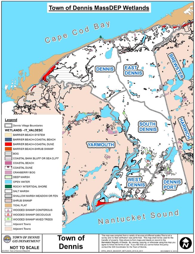
Table of Figures
Figure 1: Town of Dennis Regional Context Map.............................................................................................9
Figure 2: Town of Dennis 1893 USGS Map.................................................................................................... 11
Figure 3: Town of Dennis MassGIS 2016 Land Use Map ............................................................................... 15
Figure 4: Town of Dennis Existing Infrastructure Map ................................................................................. 17
Figure 5: Town of Dennis Zoning Map .......................................................................................................... 20
Figure 6: Town of Dennis 2010 Census Environmental Justice Populations Map ........................................ 22
Figure 7: Town of Dennis MassDEP 10’ Contours Map................................................................................. 24
Figure 8: Town of Dennis USDA NRCS Soils Map .......................................................................................... 27
Figure 9: Town of Dennis MassDEP Major Watersheds Map ....................................................................... 30
Figure 10: Town of Dennis Major Water Features Map ............................................................................... 32
Figure 11: Town of Dennis FEMA Flood Hazard Zones Map ......................................................................... 34
Figure 12: Town of Dennis MassDEP Wetlands Map .................................................................................... 37
Figure 13: Dennis Fresh Water Courses ........................................................................................................ 38
Figure 14: Town of Dennis Zones of Contribution Map ................................................................................ 40
Figure 15: Town of Dennis Natural Heritage and Endangered Species Layers Map ..................................... 45
Figure 16: Town of Dennis Scenic Resources and Unique features Map...................................................... 50
Figure 17: Town of Dennis Environmental Vulnerabilities Map (Cape Cod Commission MVP 2019) .......... 54
Figure 18: Large, Unprotected, Undeveloped Land Parcels, Dennis MA, 2019 ............................................ 57
Figure 19: Town of Dennis Open Space Inventory Town-wide Map............................................................. 61
Figure 20: Town of Dennis Open Space Inventory Dennis Village Map ........................................................ 62
Figure 21: Town of Dennis Open Space Inventory Dennis Port Map ............................................................ 63
Figure 22: Town of Dennis Open Space Inventory East Dennis Map ............................................................ 64
Figure 23: Town of Dennis Open Space Inventory South Dennis Map ......................................................... 65
Figure 24: Town of Dennis Open Space Inventory West Dennis Map .......................................................... 66
Figure 25: Town of Dennis Five Year Action Plan Map ................................................................................. 86

                                                                       3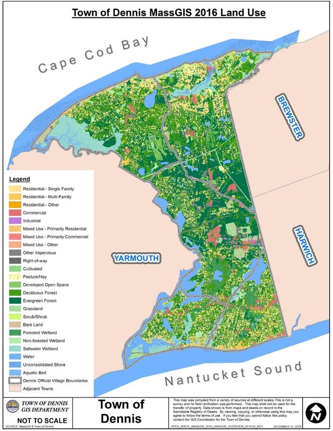
Section 1. Plan Summary

The Town of Dennis is a community with a careful balance of land preservation, natural resource
protection, and economic development. While much of the private land holdings are developed, the
town has gone to great efforts to review the remaining undeveloped parcels to determine their value for
open space preservation, water supply protection, flood prevention, and recreational opportunities. The
town is cognizant of the fact that a significant portion of its housing stock consists of second homes, used
only during the summer season. These second home owners place two significant burdens on the town,
in terms of preservation. First, the town must ensure that the beaches, golf courses, and open areas that
attract these seasonal residents to the community are protected to ensure the continued health of the
town’s seasonal economy. Second, the town needs to consider the potential future needs, for open
spaces, water supply, etc., that may occur if these second homes ever became used as year-round homes.

This plan serves as an update to previous plans, highlighting the accomplishments, noting areas where
additional work may be necessary, and identifying new goals for the town to pursue in the next five years.
This update, as with earlier plans, incorporates goals of protecting natural resources, conserving open
space, providing protection against flood damage, and providing a varied recreation program. The plan
seeks to address these goals simultaneously where possible by encouraging preservation of open space,
while allowing opportunities for its enjoyment through modest improvements which provide access for
passive recreation.

This update incorporates goals for accessibility for both recreation and open space facilities. There
continues to be an emphasis on open space preservation by means other than direct acquisition, such as
through conservation restrictions, donation, and zoning techniques. However, acquisition is still
necessary to preserve critical resources.

The plan represents the combined efforts of several town committees and departments, including the
Planning Board, Recreation Commission, Beach Commission, Conservation Commission, Community
Preservation Committee, Board of Selectmen, Dennis Economic Development Committee, Dennis Port
Revitalization Committee, South Side Civic Association, Town Administrator’s Office, Town Planner’s
Office, Natural Resources Department, Department of Public Works, Harbormaster’s Office and the Beach
and Recreation Department.

The Open Space and Recreation Plan serves as an element of the Dennis Local Comprehensive Plan (LCP).
The LCP was endorsed by Dennis Town Meeting on September 23, 2002. The Local Comprehensive Plan
serves as the town's response to the Cape Cod Regional Policy Plan to guide planning and growth
decisions overall for the town.

Since the last OSRP update, the Town has actively partnered with the Dennis Conservation Land Trust and
the Water District to purchase environmentally sensitive lands in the Chase Garden Creek and the Bass
River watersheds. The Town Lands Inventory, in process under the direction of the Board of Selectmen,
will identify priority uses of Town municipal properties and help ensure these lands are used
appropriately. This Plan will provide an ongoing framework to continue such purchases and identify
ongoing needs to improve public access to existing and newly purchased lands. The Town continues to
expand public recreational opportunities through upgrades of boat access at town owned landings,
improvements at Sesuit Harbor, and the construction of new ball courts around town.

The Town has also completed an ADA Assessment of Town owned properties. This Plan will serve to guide
renovations of existing Town buildings, parks, beach facilities, and conservation areas to improve access
for people with disabilities.
                                                     4
Lastly, this Plan sets out potential projects and outlines a framework for inclusion of these projects within
the existing Town Capital Outlay Project process, Community Preservation Act funding, and the State land
grant process. This ensures costs and timing of new projects and project upgrades will be part of the
overall Town funding mechanism.

The overarching goals identified in this open space plan include the following:

GOAL 1: Preserve land for open space and recreation, focusing acquisitions on priority properties and
connections to existing open space.

GOAL 2: Maintain and improve existing recreational properties and facilities, while exploring additional
recreational opportunities throughout town.

GOAL 3: Upgrade Town facilities to provide ADA accessibility.

GOAL 4: Preserve the historic and scenic character of the Town.

GOAL 5: Protect water quality and drinking water supplies.

GOAL 6: Promote a cooperative and regional approach to open space and resource protection.

                                                      5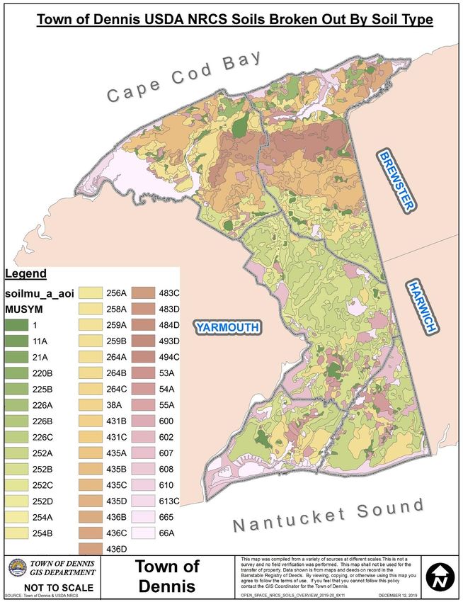
Section 2. Introduction

A. Statement of Purpose
The Dennis Open Space and Recreation Plan provides a framework for decision-making by its residents.
The purpose of the update is to serve as a guide to responsible action to conserve Dennis' natural
resources, preserve its open space, enhance flood protection, and provide ample opportunities for
recreation for its citizens.

PREVIOUS EFFORTS
This plan represents over 40 years of open space and recreation planning in the Town of Dennis. The
town has been active in the implementation of the open space and recreation recommendations found in
the 1998, 2003, and 2008 Open Space and Recreation Plan Updates.

Recent updates to the Plan occurred in 2003 and 2008. These updates identified several key open space
and recreational protection items. Top-most in these were the protection of the Quivet Neck/Crowe’s
Pasture Area and Sea View Park along the Bass River, which have been purchased and upgraded to allow
recreational access. Crowes Pasture in East Dennis represents the largest conservation area in the Town.
This property is managed for several recreational activities including, ORV use, shellfishing, hunting,
horseback riding, hiking, and bird watching. The grassland pasture is maintained through controlled burns
and mowing to keep out invasive plants. Bluebird nesting is monitored by the Cape Cod Bird Club. The
Bass River Park was completely repurposed in 2009-2010. The area is now used as a public park with
seating areas and a pavilion. Located on the shore of the Bass River in West Dennis, the park provides
newly built and renovated docks for additional public docking space. Kayaks are rented to the public and
the park connects to an adjacent conservation area via an unimproved trail. Seaview Park, located in
Dennisport, provides several recreational opportunities. The park contains community gardens, walking
trails, a small pond, playground, and two new multi-purpose courts completed in 2016. A portion of the
property remains in conservation status and a third parcel is a favorite beach area. The Town continues
to provide improvements, recently upgrading drainage facilities from the pond, and funding a project to
restore wetlands and improve water quality within the pond.

RECENT EFFORTS
Since the last Plan update in 2008, the Town has been busy with new land purchases, construction of new
beach and park facilities, and conservation land improvements.

The most recent land purchases include:
    • 2013 Grassy Pond Woodlands: 9.57 acres of land along Grassy Pond in East Dennis
    • 2016 Holl Property: 8.15 acres of land abutting the Princess Beach Property on the shore of Scargo
       Lake in Dennis
    • 2019 Bush Property: 13.11 acres of land abutting Indian Lands Conservation Area in South Dennis,
       including a historic boat house on the banks of the Bass River

Recent beach and recreational facility upgrades include:
   • 2009-2015 Seaview Park: Installation of signage, walking trails, picnic areas, community garden,
       naturalized landscaping, osprey pole, playground, ball field, fencing, and parking lot
       improvements.
   • 2015 Corporation Beach concessions upgraded.
   • 2016–2019 Comfort station and playground upgrades at beaches and parks.
   • 2018/2019 Mayflower Beach: Construction of a new concession stand and bathhouse.
   • 2018/2019 Multi-use courts installed at Seaview and Wixon.
                                                     6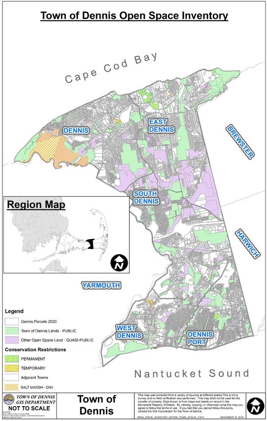
Recent conservation land improvements include:
   • 2012 Pond Street Blueberry Patch: The DNR removed invasive species from this abandoned
        blueberry patch and restored blueberry bushes, allowing the patch to be reopened for public
        picking.
   • 2013 Flax Pond: Improvements to the parking lot; installation of a kiosk, fencing, trash receptacle,
        and signage.
   • 2013 Conservation Area sign installations: New town conservation area signs were installed at the
        entrances to several properties throughout town with hiking trail access.
   • 2014 Princess Beach: Replacement of restrooms, picnic pavilion, septic tank and leach field;
        installation of new picnic tables, grills, signage, and kiosk.
   • 2019 Indian Lands: A section of this popular hiking trail along the banks of the Bass River were
        closed off due to erosion, with a new path constructed further inland. Additional split rail fencing
        was installed to keep walkers away from the steep banks. New trail markers were also installed.

B. Planning Process and Public Participation
This update builds upon past community needs and priorities surveys, and public forums addressing open
space, flood prevention, and recreational needs. Residents were asked to assess the condition of town
recreational facilities and to provide recommendations as to the priority of expenditures on open space
and recreation. The survey was dispersed throughout town, and was responded to by 358 residents.

The plan represents the combined efforts of several town committees and departments, including the
Planning Board, Recreation Commission, Beach Commission, Conservation Commission, Community
Preservation Committee, Board of Selectmen, Dennis Economic Development Committee, Dennis Port
Revitalization Committee, South Side Civic Association, Town Administrator’s Office, Town Planner’s
Office, Natural Resources Department, Department of Public Works, Harbormaster’s Office, and the
Beach and Recreation Department.

                                                     7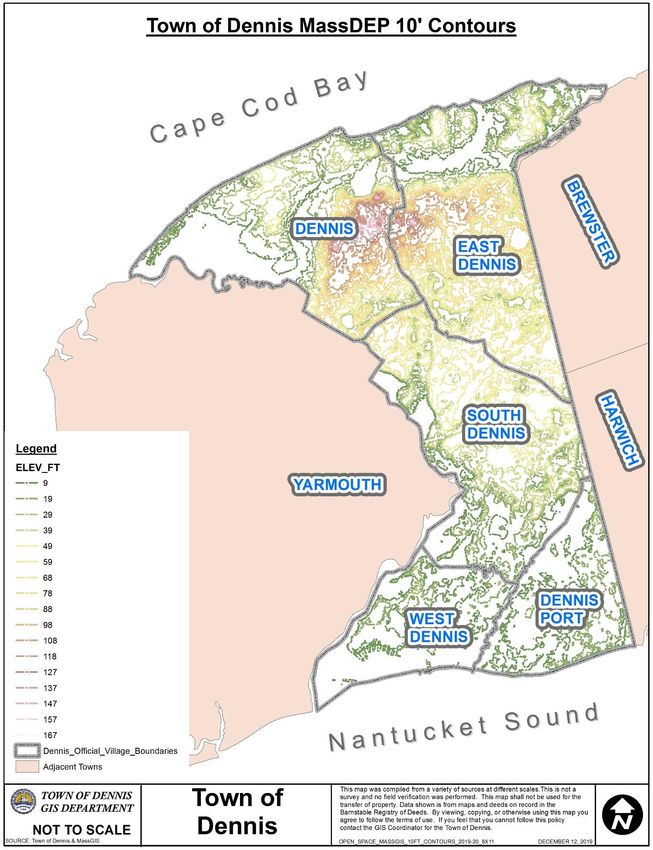
Section 3. Community Setting

A. Regional Context
Located in the middle of Cape Cod, Dennis is 85 miles from Boston and 260 miles from New York City. The
town covers seven and a half miles north to south and ranges one and a half miles to four miles in width.
The ninth largest-area town (of 15) on Cape Cod, Dennis encompasses 20.66 square miles of land area, or
13,645 acres, and is bounded on the north by Cape Cod Bay, on the east by the Towns of Brewster and
Harwich, on the south by Nantucket Sound, and on the west by the Town of Yarmouth. Dennis is one of
only three Cape towns which retains its original shore-to-shore boundaries between Cape Cod Bay and
Nantucket Sound. The significance of this layout lies in the diversity offered by the two distinctly different
marine ecosystems, and recreational attributes of the different shorelines. Dennis’ planning districts
include Dennis Village, Dennis Port, East Dennis, South Dennis, and West Dennis.

Dennis is engaged in the natural resource and planning issues of Cape Cod through participation in the
Assembly of Delegates, Cape Cod Commission, Shellfish Advisory Board, Cape Cod Pathways, Regional
Transit Authority, and other regional organizations. Cooperative ventures in protecting the Bass River and
Chase Garden ecosystems require partnerships with the Town of Yarmouth; protecting the Quivett
Creek/Bound Brook watershed has required a partnership with the Town of Brewster, the Dennis
Conservation Land Trust, Brewster Conservation Trust and the Cape Cod Commission; and protecting the
drinking water supply of the Town of Dennis has required a partnership between the Dennis Water
District and the Town of Brewster. As with the entire Cape area, Dennis is served by a sole source aquifer,
the Monomoy Lens. Because public wellfields in the eastern side of town draw ground water from
Dennis, Harwich, and Brewster, the town participates in the Monomoy Lens Groundwater Protection
Project with its municipal neighbors through the Cape Cod Commission.

Potential regional and neighboring threats to the quality of resources and open space in Dennis include
continued development, particularly given Dennis' proximity to Hyannis, Cape Cod's commercial core and
transportation hub. This growth could impact regional resources such as water quality, coastal resources,
and wildlife migration.

                                                      8
FIGURE 1: TOWN OF DENNIS REGIONAL CONTEXT MAP

                     9
B. History of the Community
Archeological studies in Dennis have uncovered a history of Native American settlement along the Bass
River in South Dennis. Among the artifacts are Mounds indicating the extensive use of shellfish and its
importance for subsistence to the earliest inhabitants. Major Native trails followed the riverbanks north
and south (on what is now Mayfair Road, the southern end of Old Bass River Road, and Main Street
through South Dennis) and east-west through town along what is now Route 6A and Setucket Road. Major
areas targeted for Archeological concerns include the Indian Lands Conservation Area along Bass River,
the Holl Property purchased in 2016 adjacent to Scargo Lake, and the Bush Property purchased in 2019
adjacent to the Bass River. Conservation Restrictions prohibit unauthorized excavations and ensure the
protection of these areas.
Dennis was colonized by Europeans in 1639 as a part of Yarmouth within Plymouth Colony, and
incorporated as its own town in 1793. Along with Sandwich and Barnstable, Dennis (as part of Yarmouth)
is one of the Cape's oldest towns. Dennis settlers were farmers first and fishermen on the side. But as
the population grew in the 1700s, and the soils became depleted, Dennis citizens looked to the sea for
sustenance and profit, through whaling and commercial fishing. In the 1800s, a full scale, multi-faceted
maritime economy developed in Dennis. Bass River was a major Southside port of the Cape.
By the mid-1800s, Dennis turned back to the land for economic pursuits, with 50 acres of planted bogs in
1855 (more than any other Cape town) growing rapidly to as many as 359 acres planted by 1889.
Throughout the nineteenth century, Dennis consistently placed in the top three of Cape towns in
cranberry acreage and/or production. Cranberrying altered the environment in many ways: cedar
swamps and other wetlands were displaced to make working bogs, dikes were used to impound streams,
adjacent banks were mined for sand, and isolated ponds were given artificial outlets and their water levels
manipulated with flumes.
By 1858, the Southside of town had a larger population and more business than the Northside. Numerous
wharves appeared on the Nantucket Sound shore at Dennis Port (then called Crocker's Neck). The
railroad extended to Yarmouth by 1854 and ten years later, on through town to Orleans, supplanting
sailing as the primary means of transport regionally.
For fifty years after the Civil War, Dennis, like the rest of Cape Cod, experienced an economic collapse.
Fishing and whaling continued their decline, midwestern farms dominated the national markets, and net
migration of the population was off-Cape.
The advent of the automobile brought about substantial change. By 1920, Dennis' population began its
rebound from nineteenth century decline, as the idea of Cape Cod as a summer resort, which was only a
germ of a vision to that point, took firm hold. Jobs grew in building homes for developments along the
southern coastal areas, and the foundation of the tourist economy took shape. By the 1950s, spurred by
the post-World War II boom, Dennis' character as a seaside resort was entrenched. Beachfront motels
and cottage colonies blanketed the Southside, where warm waters and sandy shores provided excellent
swimming and sunning conditions. Route 28 firmly supplanted Route 6A as the town's new linear
commercial core, since there was more room for businesses to grow and it was proximate to the resorts.
Over the past 40 years, many of the former summer tourists have purchased homes and retired to Dennis,
producing the largest user group of the Cape's service economy. This still growing retirement community
has produced a greater awareness about quality of life issues in Dennis and on the Cape.
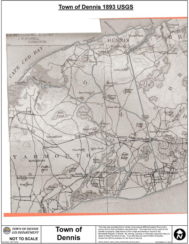
10FIGURE 2: TOWN OF DENNIS 1893 USGS MAP
11C. Population Characteristics
Dennis hosts about six and a half percent of Barnstable County's population (2010 Census) on five percent
of the land in the county. Growth in Dennis, as on the rest of Cape Cod, was dramatic during the 60’s and
70’s. However, 2010 US Census counts illustrate a dramatic drop in year-round population in the first
decade of the 21st century. Factors influencing this drop likely include the national economic downturn of
that time period, young people leaving the area, and the higher than normal housing costs on Cape Cod
due to the large second home market.
From 2000-2010, Dennis lost 1,766 year-round residents, 11% of those living here in 2000. The under 18
population dropped by 720 people in the decade. This is nearly a 27% drop in this segment of the
population in the decade. Given overall population dropped by only 11.1%, and in 2000 the under 18
population was 17% of the total population in Dennis, it is safe to say that the young people in Dennis in
2010 made up a smaller share of the town’s population than in 2000.
The Census data confirms that families with young children were leaving town in the preceding decade.
The 18 and over population dropped as well, by 1,046 people, or 6.5%. This drop in year-round
population is nowhere near as dramatic as in the younger age group. Interestingly, Dennis lost significant
population in the oldest age cohorts, decade over decade as well. The 70 plus population in 2010, which
represents the 60 plus age cohort in 2000, shows a drop of 1,248 people. This change includes deaths,
but also represents others who have simply chosen to not winter on the Cape any longer.
Dennis’ population gain occurred in the age cohort that was between 40 and 60 years old in 2000. This
age cohort grew by 509 people during the past decade. Ultimately, the loss of younger people, and the
growth in people between 50 and 70, results in a significantly older Dennis. In 2000, the median age was
49.4. In 2010 the median age has jumped to 55.1. Men are younger than women, with a male median
age of 53.2 (up from 47.9 in 2000) and female median age of 56.8 (up from 50.7 in 2000).
Over the past decade, while the state was growing by about 3%, Barnstable County was losing population,
with nearly a 3% loss. When compared to our neighbors and the rest of the Cape, Dennis population
figures dropped dramatically, with the largest population drop percentage wise on the Cape. Beyond the
year-round population numbers, Dennis, experiences a fairly substantial population change during the
summer months. As will be discussed later, total housing units increased in Dennis between 2000 and
2010. All of this, and the housing vacated by families leaving the area in the decade, were absorbed by
second home owners. The net result is, if we considered only the population in housing units, Dennis had
an estimated summer population of between 30,827 and 61,805 people in 2010, the lower number using
the average people per housing unit for year-round occupancy and the higher number being based upon
Board of Health information on seasonal housing occupancy permits. In 2000, the seasonal population
ranged between 28,800 and 52,129. These figures suggest a growth in summer population of between
2,000 and 9,000 people, before counting those in hotel rooms, cottages and recreational vehicles. In the
past, we had estimated total summer population at about 70,000 people, it is now likely that we are
approaching 80,000 people.
The increase in summer over winter population is more than five-fold (14,207 to an estimated 70,000 to
80,000). Excluding towns within the Cape Cod National Seashore, Dennis experiences the greatest rate of
change between winter and summer populations of any town on Cape Cod. This change is due to the high
rate of seasonal homes in Dennis. Dennis has about 51% of its housing occupied seasonally.
IRS data estimated a loss of 2,673 between 2004 and 2008 for Barnstable County, a figure that is nearly
one-half the population loss estimated by the Census Bureau for the County. Census Bureau interim
population figures (released annually between Census Counts) suggested that Dennis alone lost 631
12people in this time period. The IRS tax return data provided a strong picture, mid-decade of the out-
migration trend of the population from the Cape.
Dennis year-round population (from which the remaining comparisons are drawn) continues to grow
older. The town’s median age jumped to 55.1 years old since 2000 (49.4 years old). This median age is
significantly higher than our neighbors Yarmouth (51.4 years), Harwich (52.6 years) and Brewster (53.5
years) as well as in relation to the rest of the Cape’s median (49.9 years) and the Commonwealth’s (39.1
years).
The 65+ age bracket is the fastest growing segment of the population in real numbers, having increased
by more than 3,000 people over the last thirty years. Children make up a smaller portion of the overall
population than in the past. The implications of this aged population factor for open space and
recreational services are, all else being equal, the town should perhaps emphasize more leisure activities
oriented towards older citizens, such as developing pocket parks in the individual Dennis villages, walking
paths, sidewalks, benches, and, handicapped access.
In addition to having an older population than other Cape towns, Dennis continues to experience a
decrease in wealth. Household income in 2013 was $50,672 for Dennis, the fourth lowest of the 15 towns
on Cape Cod. In 2013, 12.3% of Dennis families lived below the poverty level compared to 12.8% in
Barnstable County. However, 37.6% of families with children under the age of 18 live in poverty and
45.1% of all Dennis residents under age 18 lived in poverty in 2013. Implications of the town’s
demographics include the need to provide recreational opportunities that are affordable for most people,
to look to the needs of the very young, and to provide for the expanding elderly population.
Looking at these numbers in a different way, in 2013 39.8% of the households living in the town of Dennis
are considered as either low or very low-income households. These households would qualify for
subsidized housing under MGL Chapter 40B. In comparison on the county wide basis 38.2% of the
households are so classified.
Walking trails, scenic lookouts, and sidewalks may be appropriate supplements to active recreation
facilities (such as tennis or basketball) or private health clubs. In general, passive recreation should be
emphasized along with active recreation to serve the needs of the entire Dennis community. Items as
simple as a bench to stop and catch one's breath along a hiking trail would be useful. The town is
obligated to provide safe and convenient outdoor enjoyment for disabled people, many of whom may be
elderly. Benches, firm footing, safe parking access should be easy, yet important, design considerations.
The economy of Dennis is still largely dependent upon the tourist trade and servicing retirees. In 2008,
the town had 552 businesses, down from 594 in 2006. Annual total wages of $133,059,000 were a drop
from two years earlier, and annual employment was at 3,732 people employed, a drop of 1,000 people in
2006. This was likely due to the impacts of the recession in Dennis. In March of 2015 Dennis still had an
unemployment rate of 9.6%, fourth highest in Barnstable County and still reflective of the lack of recovery
in the year-round jobs picture.
Nearly 42% of those employed in Dennis in 2008 were employed in either retail trade or the
accommodations and food services industry. Reflecting the nature of the local economy, health care and
social assistance ranked as the third largest employment industry. Stop and Shop continues to be the
largest employer in Dennis, the second largest being the Cape Cod Regional Transit Authority, followed by
Dennis Port Culinary, Eagle Pond Rehabilitation Center, Elder Services of Cape Cod and the
Dennis/Yarmouth School System.
There has been a revived interest in determining actions that the town could take to stabilize the local
13tourist economy. These actions include looking at ways to modernize the existing tourist
accommodations, and to determine how increased tourist activities can be accommodated without
denigrating the natural environment. This conclusion is supported by the recent Open Space and
Recreation Survey conducted by the Town of Dennis Planning Department which showed that 56% of the
respondents recognize the town is a resort town and reliant upon the visitors to the town.
D. Growth and Development Patterns
PATTERNS AND TRENDS
Dennis colonists originally divided their settlement into common property and private farming lands, with
salt marshes as commons used for grazing cattle. Private land typically ran in north-south strips (called
‘long lots’) from the beach back to the moraine ridges. This pattern enabled each colonist to have a slice
of different habitat for various land uses. This north-south strip pattern is still a relict today in some areas
along the Northside. Its significance lies in its ability to prevent land assemblage for some large-scale
developments (or, conversely, for large conservation blocks).
Year-round, Dennis has 687 permanent residents per square mile. In the summer, Dennis is densely
populated as the motels, cottage colonies, and second homes, particularly on the Southside, fill up with
summer residents, guests, and tourists. During this season, Dennis swells to over 3,000 people per square
mile. Owing to municipal foresight, there are large areas of protected undeveloped land. About thirty
percent (4,065 acres) of the town's land mass has been set aside as protected open space for wellfields,
conservation land, and beaches. The town continues to vigorously pursue opportunities to purchase open
land; since the adoption of the 2008 Open Space and Recreation Plan, the town has acquired over 70
acres of open space through private donations, Community Preservation Funds, and State Self-Help and
Urban Self-Help funds. In addition, the Dennis Conservation Land Trust has placed an additional 19 acres
under protection. Dennis made Cape Cod conservation history in 1967 by getting the first town-wide land
acquisition program approved overwhelmingly by town voters.
The Town of Dennis has worked to protect its small-town atmosphere while recognizing the need for
economic growth. The town has undertaken a number of zoning initiatives to promote a balanced growth
that addresses protecting natural, historic, and cultural resources, while recognizing the need for job,
housing, and tax base growth. Examples of these initiatives include the significant down-zoning that
occurred within the Crowes Pasture area as part of the town’s District of Critical Planning Concern effort,
down-zoning a portion of the West Dennis Village Center waterfront area to protect the area for
recreational and water-oriented land uses, the creation of two mixed-use village development districts,
and restrictions on formula businesses to protect community cultural characteristics over national
standardization.
The town has had cluster zoning in place for many years. However, there are very few significantly sized
tracts of land remaining where this type of zoning will be successful. It is unlikely that open space set-
asides will grow apace with development despite the cluster zoning. Significant new acquisitions of open
space must be made, through purchase or other protection means. The preservation of some of the
remaining open space may be an important way to manage growth, in addition to preserving resources
and providing recreation. Despite its density, Dennis still has a small-town atmosphere appreciated by its
citizens. The rural seaside charm is extant in views of historic homes and glimpses of bogs and marshes.
14FIGURE 3: TOWN OF DENNIS MASSGIS 2016 LAND USE MAP
15INFRASTRUCTURE
a. Transportation Systems
Town roads connect most areas and their long-established patterns leave few areas of Dennis far from
public roadways, so there are very few landlocked parcels. The major north-south corridor is Route 134.
This highway connects all five villages. East-west travel is accommodated from the northernmost corridor
comprised of Route 6A, Setucket Road, Great Western Road, Route 28, and Lower County Road as the
southernmost continuous corridor. Dennis is bisected by Route 6, a limited-access highway with a major
interchange in Dennis.
Bicycle and pedestrian facilities are found in all five villages. Most significant is the Cape Cod Rail Trail
which has a trailhead located off Route 134 in Dennis. In Spring 2016, the towns of Dennis and Yarmouth
began construction on a new extension for the Cape Cod Rail Trail. This project added 3.7 miles of paved
pathway, with new bridges built to span two major roads in both towns and the Bass River. The project
was completed in the Spring of 2019. Once the pathway is finished through Yarmouth, it will connect to
the regional transportation center in Hyannis where bus, train, and bicycle connections to most of the
Cape can be made.
In addition, Dennis has constructed bi-walks along many of its streets. This has been an on-going program
for over a decade. Dennis provides for an annual portion of its Department of Public Works budget
targeted at sidewalk improvements. This funding allows for one to two miles of new or upgraded bi-walk
facilities to be constructed annually. These facilities emanate out from Johnny Kelley Park in South Dennis
and provides for pedestrian and bicycle connections along Old Bass River Road, Bob Crowell Road, Old
Chatham Road, and Route 134 between the park and nearby schools and affordable housing facilities. On
the south side, significant upgrades to sidewalks and bicycle facilities have been constructed along Lower
County Road and Old Wharf Road, providing significant improvements for non-motor vehicle access to
Dennis beaches.
b. Water Supply Systems
Town water service extends throughout town and all but a small portion of the homes in town are served
by public water lines. Since Dennis relies on groundwater for all of its drinking water supply, there is
anxiety about protecting water quality. Rising nitrogen levels have been found in some wells, indicating
that overdevelopment of some parts of town has caused water quality to deteriorate. At present, strong
local Board of Health and Conservation Commission regulations are in place to help address water quality
issues. The town is moving forward with implementing its Comprehensive Wastewater Management
Plan.
c. Sewer Service
In terms of existing infrastructure, there is no sewer service in Dennis. The town is in the process of
implementing its Comprehensive Waste Water Management Plan; the timing of this effort makes it
unlikely that any sewer services will be in place during the five-year scope of this plan.
16FIGURE 4: TOWN OF DENNIS EXISTING INFRASTRUCTURE MAP
17LONG-TERM DEVELOPMENT PATTERNS
Most of the town is zoned for residential use with a minimum lot size of 40,000 square feet except for
long-settled areas, such as along the Dennis Port shore, where many smaller lots are still buildable owing
to the zoning protection known as ‘grandfathering’. Two-thirds of the land north of Route 6A is zoned for
larger lots (60,000 square-feet minimum), reflecting the still-rural flavor of the area and its historic
integrity. In 2010, there were 15,035 housing units in Dennis according to the US Census. Other towns in
the Monomoy Lens study area are only 65 to 75 percent built-out, while Dennis has already achieved 97
percent or more of its residential development potential.
The industrial zone, which includes the town landfill, extends south of Route 6, east of Route 134, and
north of Great Western Road. This location removes it from residential areas, but, intrudes into the
woodlands around Eagle Pond. Much of the recharge area to Public Supply Well #13 by Swan Pond is
overlain by the industrial zone and the landfill, and this well has been abandoned, eliminating the last
public water supply source south of Route 6 in Dennis. The Dennis industrial district contains a variety of
uses, including mining, solid waste disposal, resource reclamation, contractor’s businesses, warehousing,
and intensive recreational uses. The land use map illustrates that nearly half of the non-town owned land
in the Dennis Industrial Zone is used for commercial purposes, and nearly 80% of the industrial land with
roadway frontage is so used.
Business and commercial zones follow Route 28, parts of Route 6A and Hokum Rock Road, and portions of
Route 134. As of 2008, approximately 665 acres of land are developed for commercial or industrial land
uses and 6,091 acres are developed for residential uses.
In addition to town-wide growth patterns, it is useful to analyze village development trends because
Dennis is a large town in area and facilities that may serve the needs of one village may simply be too
distant to be readily available to use by residents of other villages. Dennis Port, except for one large tract
that had been used for a private recreational facility, has few tracts remaining for development and can
be considered essentially built-out relative to the rest of town. West Dennis likewise has few remaining
large tracts except for undevelopable Weir Creek wetland parcels; some Grand Cove estates could be
broken up into smaller building lots.
Heavily developed along its western perimeter, South Dennis contains the greatest potential for more
large subdivisions. Land protection for the woodland backdrop to the historic homes along the streets in
the South Dennis Village Historic District should be a priority. In this regard, the Dennis Conservation Land
Trust purchased two wooded commercial lots in 1995, which were visible from Liberty Hall.
The Northside villages (Dennis and East Dennis) exhibit some of the most rural patterns of development
(large estates on Sesuit and Quivet Necks) and some of the most suburban patterns (acre-lot, grid
subdivisions popular in the 1970s, such as near Black Ball Hill and Scargo Heights).
The population in the five planning districts should, eventually, tend to be more equivalent, as the
Northside continues to grow and West Dennis finishes up in its development, though Dennis Port will
probably always lead in density.
Beyond the spatial considerations of development in Dennis, there is also a temporal component. The
fact is that in each decade between 1960 and 2000, housing units in Dennis became increasingly used
year-round. After 2000 the trend reversed. As of the 2010 Census 51% of the homes in Dennis were
occupied on a part time basis.
Whatever the cause(s), summer-only occupied housing units in Dennis declined from 79 percent in 1960
18to 48 percent in 1990, and 42.7% in 2000, even as the raw number of units has grown steadily. In 2010
this trend reversed with just over 51% of all housing being seasonal in the 2010 Census.
Since Dennis is mostly built-out now, the more crucial impacts on water demand, water quality, open
space demand, traffic, and other issues are as likely to come from seasonal to year-round conversion of
existing housing stock as from more development in general. Currently, the town regulates the
conversion of cottage colonies (three or more seasonally occupied units) by requiring they be supported
by 40,000 sf per unit before conversion to year-round housing is allowed. These cottage colonies
represent only a fraction of the seasonal housing in Dennis. The conversion of existing seasonal homes on
individual parcels could double the population of town, without any increase in land consumption.
However, this population change would dramatically increase the demand for town services, without
generating any increased tax revenue.
19FIGURE 5: TOWN OF DENNIS ZONING MAP
20E. Environmental Justice and Equity
In 2002, the Massachusetts Executive Office of Energy and Environmental Affairs adopted an
Environmental Justice Policy to provide equal protection and meaningful participation for all
Massachusetts residents with respect to environmental regulations and policy making. The policy also
supports equitable access to environmental assets including parks, playgrounds, open areas and
recreation areas. Dennis has Environmental Justice areas located in Dennis Port and West Dennis (the
West Dennis area extends slightly into South Dennis). The Dennis Environmental Justice areas include the
concentration of low-income populations. All of these areas have been the focus of intensive planning
efforts by Dennis over the past fifteen years. New village center zoning and other creative approaches to
providing affordable housing have been adopted to improve conditions in and adjacent to these
Environmental Justice areas with allowances for multi-family housing in close proximity to employment
opportunities. Coupled with these zoning efforts, the town has gone to significant efforts to improve
recreational and open space opportunities in and around these Environmental Justice areas.
In Dennis Port, the town has upgraded the facilities at Mike Stacey Park, located in the heart of the Village
Center and serves the Environmental Justice area. In addition, the town has acquired several open space
tracts along both Route 28 and Upper County Road. These include a large acquisition adjacent to Dennis
Commons, an affordable housing project developed under Chapter 40B. The town has also acquired the
17-acre Sea View Park which includes ocean access.
In and around both of the Environmental Justice areas the town has also made significant public building
improvements, constructing a brand-new public library in Dennis Port and turning the West Dennis
Graded School House into a public meeting area. Upgrades to the West Dennis Accessible Playground
were completed 2018 with equipment upgrades and a new play surface. The town also acquired the
former Howlin’ Howies snack bar site and converted it into the Bass River Park recreation area complete
with an elevated walkway, canoe and kayak launch, and boat moorings. In addition, major sidewalk
improvements are underway in Dennis Port along Route 28, Upper County Road and several connecting
side streets. This project will connect the area from the Dennis Port Village Center to the Dennis
Commons housing project with a complete streets sidewalk improvement. A similar project is expected to
start construction in West Dennis connecting the waterfront to several locally approved affordable sites
along Route 28.
Dennis planning staff works closely through-out the year with residents and business owners in both
these areas. Regular discussions are held regarding the needs for these parts of town with
the South Side Civic Association, Dennis Port Revitalization Committee, Dennis Port Merchants
Association etc.
21FIGURE 6: TOWN OF DENNIS 2010 CENSUS ENVIRONMENTAL JUSTICE POPULATIONS MAP
22Section 4. Environmental Inventory and Analysis
The natural resources, physical development, and social structure of Dennis creates unique problems and
opportunities for open space, conservation, and recreation planning. This section examines how the
natural environment has influenced the development and culture of the town, and which resources are
the most vulnerable and important to preserve.
A. Geology, Soils, and Topography
1. Geology and Topography
Dennis has three distinct physiographic regions, with its major landscape features formed during the
retreat of the Wisconsin glacier about 15,000 years ago. Wind, wave, and storm action has shaped dunes,
beaches, and other shoreline features, but Dennis is primarily characterized by its glacial past.
Eight percent of the town is underlain by kame deposits, soils laid down into still water by the glacier's
streams. The kame area stretches along the south side of Route 6A from the commercial centers of
Dennis Village and East Dennis. In effect, the Native American trail that became Route 6A was laid out
along the northern toe of the kame slope. The kame hills include the town's high spots (Scargo Hill 160
feet; Black Ball Hill 159 feet; and Hokum Rock 150 feet), steep slopes, generally without the clays
associated with moraines. No ponds and few wetlands exist in this arid, sloping kame deposit. Large
boulders are strewn across the kame, including the legendary Hokum Rock, a large erratic boulder found
near the town sandpit on the south side of Hokum Rock Road.
The kame is Dennis’ most rugged landscape and quite scenic, although residential development on the
north side of Scargo Hill has marred that topography. At 160-feet high, Scargo Hill rises over Scargo Lake,
with the stone observation tower on its summit serving as a focal point.
Lands north of Route 6A comprise the second physiographic region, roughly 13 percent of the town.
Glacial lake and lake bottom deposits are found inside the Cape Cod Bay shoreline. The high kame acted
as a giant earth dam, causing a temporary lake to form, with silt, clay, sand, and gravel settling out. The
richest soils are found in this north part of town. Gently-rolling hills with slopes averaging six percent
extend to dramatic sea cliffs and bluffs overlooking Cape Cod Bay. Extensive salt marshes and broad tidal
flats fringe these glacial lake delta deposits, along with a few small, shallow ponds. West of Nobscusset
Point, clays support nearly vertical sea cliffs rising directly from the beach 40 feet high.24
Most of the remainder of Dennis is composed of outwash plain deposits, sands and gravels sorted by
meltwater running south off the glacier. The generally flat surface is pitted in places where blocks of ice
became separated from the main mass of the glacier, were buried in the drift and later melted, leaving
steep-sided depressions, known locally as kettle holes. The deeper depressions extend below the water
table and now contain the town's many ponds.
Shallower depressions contained many of the town's larger cranberry bogs. The land surface is very
uniform throughout this third physiographic unit: no land above 50 feet high exists south of Route 6 and
no land above 20 feet exists south of Route 28.
23FIGURE 7: TOWN OF DENNIS MASSDEP 10’ CONTOURS MAP
242. Soils
a) Description
Different soils result from complex interactions among surficial geological forces, topography, climate,
and plant and animal decomposition. The type, wetness, and slope of soils often determine the suitability
of land use development in a community. Soils affect drainage, erosion, sedimentation, agriculture,
vegetation, wildlife habitat, sewage disposal, and suitability of concrete foundations. In Dennis, particular
concern should be given to uses of soil that are easily eroded, excessively or poorly drained, unstable or
ecologically-important. The Natural Resources Conservation Service identifies five general soil types in
Dennis, described below.
Carver and Eastchop series: These sands comprise about 49 percent of the town's area (6,850 acres),
typically within the outwash plain south of Setucket Road. These droughty, nutrient-poor soils are usually
found on level or gently sloping land. Carver and Eastchop soils have few limitations for development, but
the ready permeability of the soils allows potential contaminants to reach the water table. This can
present issues with septic systems, with nitrogenous compounds from wastewater easily reaching the
aquifer before soil adsorption can occur. Lawns and athletic fields may also be difficult to establish and
maintain owing to the droughty nature of the soils.
Plymouth series: An upland soil primarily associated with the hilly kame areas north of Setucket Road and
in pockets along the Northside. These droughty soils are very stony and boulder-strewn and comprise
about 23 percent of the town's area (3,221 acres). Steep slopes, exposed boulders, and occasional clay
layers can pose development issues. The large town sandpits on Hokum Rock Road are excavated in
Plymouth soils.
Deerfield - Belgrade - Walpole - Merrimac - Hinesburg - Boxford series: An upland soil which comprises
only three percent of the town's area (416 acres), but which are important agricultural soils. These are
found primarily on the Northside, north of Route 6A, but also along the drainages of Swan Pond and Weir
Creek on the Southside. The Northside locale coincides with the first colonial settlement in Dennis, where
small farmsteads benefited from the relatively rich loamy sand. The largest swatches of prime agricultural
soils that have not yet been developed underlie parts of Sesuit Neck and Quivet Neck.
Wetland soils include tidal marsh, dune sand and beach sand (11 per cent of town or 1,619 acres) and the
peat, muck, and sanded muck association of freshwater swamps, bogs, and marshes (six percent or 798
acres) found scattered throughout the town.
Even though most of Dennis was originally stabilized by vegetation, and a thin veneer of topsoil began to
accumulate over it, supporting upland forests, the colonists soon stripped the timber from the woods and
the topsoil blew away, leaving loose sand in many areas.
b) Agricultural Resources
The farming community that was Dennis in the 18th and 19th centuries is long gone, with remnants of
that heritage including stone walls and abandoned orchards scattered across town. There are still a few
small working farms in Dennis, including Tobey Farm, Cape Abilities Farm, The Tree Farm, Hart Farm, and
Mike’s Organic Gardens.
The waterfront location of the town also promotes aquaculture, a growing agricultural use in Dennis,
making use of the privately-owned Aquatic Research Corporation (ARC) on Chase Garden Creek, and
public resources in East Dennis off Crowe’s Pasture. Aquaculture farms raise oysters and quahogs for use
by local restaurants and sale at local fish markets.
25In 2015, Dennis, Yarmouth, Barnstable County, the Dennis Conservation Land Trust, the Commonwealth
of Massachusetts, and others stepped up and created a mechanism for the long-term survival of the ARC.
The project involved acquiring surrounding open lands for conservation purposes and acquiring all non-
agricultural development rights for the actual site of the ARC. By doing this, the ARC was able to arrange
proper financing to upgrade the shellfish hatchery facility in Dennis.
Dennis now hosts three community garden sites: the two-acre Shoop Memorial Gardens on Route 6A in
East Dennis, located on 25 acres of town conservation land with nature trails; the 2.67-acre Elizabeth Burr
Garden in West Dennis; and at Sea View Park approximately one acre was set aside for garden areas,
including raised bed facilities that are wheelchair accessible. In addition, the town runs two public
blueberry picking patches: Cross Patch in Dennis Village, and Pond Street Patch in West Dennis.
In order to promote and protect the agricultural uses in town, Town Meeting created an Agricultural
Commission at the May 2008 Annual Town Meeting. The same town meeting also recognized the town as
a Right-to-Farm community. Major agricultural uses in the area are located at Cape Abilities Farm in
Dennis Village, Hart Farm Nursery and Garden Center in Dennis Port and Melpet Farm in South Dennis.
The Town maintains two (2) blueberry patches which are open to public picking in the summer, and three
(3) Community Gardens which are leased to individual residents for cultivation annually. The Steven
Phillips cranberry bog is maintained as an agricultural property and the Whitfield Johnson parcel is
mowed annually to maintain the pasture.
26You can also read


