TRANSPORTATION IMPROVEMENT PROGRAM FOR THE OCARTS TRANSPORTATION MANAGEMENT AREA - FFY 2022 - FFY 2025 October 1, 2021 - September 30, 2025 ...
←
→
Page content transcription
If your browser does not render page correctly, please read the page content below
4205 N. Lincoln Blvd. | OKC

TRANSPORTATION IMPROVEMENT
PROGRAM FOR THE OCARTS
TRANSPORTATION MANAGEMENT AREA
FFY 2022 – FFY 2025
October 1, 2021 – September 30, 2025

PRELIMINARY
ASSOCIATION OF CENTRAL OKLAHOMA GOVERNMENTS
Mark W. Sweeney, AICP .......................................................................................................... Executive Director
John M. Sharp ................................................................................................................................... Deputy Director
Beverly Garner........................................................................................................................... Executive Assistant

TRANSPORTATION PLANNING SERVICES
Jennifer Sebesta ..............................................................................................................................................Manager
Hannah Nolen ......................................................................................................................Projects Coordinator II
Jordan Evans...................................................................... Associate Transportation Planner – Multimodal
Lauren Wood ................................................................. Associate Transportation Planner – Performance
Eric Pollard ............................................................................................ Air Quality & Clean Cities Coordinator
Angela Hankins ................................................................................................................Special Projects Planner
Gwendolyn Gordon ....................................................................................................... Administrative Assistant

Association of Central Oklahoma Governments
4205 North Lincoln Blvd
Oklahoma City, OK 73105

Telephone: (405) 234- 2264
www.acogok.org

This report is the product of a project (study) financed in part by the Federal Transit Administration and
the Federal Highway Administration of the U.S. Department of Transportation.

The contents of this report reflect the views of the Association of Central Oklahoma Governments
(ACOG), the Metropolitan Planning Organization for the Oklahoma City Area Regional Transportation
Study (OCARTS) Transportation Management Area. ACOG is responsible for the facts and the accuracy
of the data presented herein. The contents do not necessarily reflect official views or policy of the U.S.
Department of Transportation. This report does not constitute a standard, specification, or regulation.

TABLE OF CONTENTS

INTRODUCTION.............................................................................................................................. 1

OVERVIEW OF PROGRAM ELEMENTS............................................................................... 7

STREET AND HIGHWAY ELEMENT ...................................................................................... 11
   OCARTS AREA PROJECTS FUNDED FROM PREVIOUS TIP ...................................................................................... 11
   FFY 2022 – 2025 STREET AND HIGHWAY ELEMENT PROJECTS ......................................................................... 19
    FFY 2022 Local Government Projects ..................................................................................................................................... 20
    FFY 2022 ODOT Projects.................................................................................................................................................................. 21
    FFY 2023 Local Government Projects ......................................................................................................................................22
    FFY 2023 ODOT Projects ................................................................................................................................................................23
    FFY 2024 Local Government Projects......................................................................................................................................25
    FFY 2024 ODOT Projects ................................................................................................................................................................26
    FFY 2025 Local Government Projects ......................................................................................................................................27
    FFY 2025 ODOT Projects ................................................................................................................................................................28

TRANSIT ELEMENT ................................................................................................................... 30

AIRPORT ELEMENT ...................................................................................................................43

PERFORMANCE MANAGEMENT ........................................................................................ 48
INTRODUCTION
BACKGROUND
The Transportation Improvement Program (TIP) is a cooperatively developed, four-year
program outlining multimodal transportation improvements and services to be implemented
within the Oklahoma City Area Regional Transportation Study (OCARTS) area.
Federal law requires that all Metropolitan Planning Organizations (MPOs) prepare a TIP for
their designated region. The Fixing America’s Surface Transportation (FAST) Act is the most
recent law establishing federal transportation policy and funding authorizations. Under this
legislation, the Association of Central Oklahoma Governments (ACOG), in its role as the MPO,
is responsible for preparing the regional TIP in cooperation with the state department of
transportation, transit operators, and local governments.
Although federal regulations require the TIP be updated at least every four years and cover a
minimum four-year period, ACOG produces a new TIP every two years and outlines federal
transportation expenditures for the subsequent four-year period. This document is prepared
under the guidance of the Intermodal Transportation Technical and Policy Committees, and is
submitted to the Governor, the Federal Transit Administration (FTA), and the Federal
Highway Administration (FHWA) through the Oklahoma Department of Transportation
(ODOT).
Capital and non-capital projects funded by the FTA, the FHWA, and the Federal Aviation
Administration are required to be listed in the TIP to be eligible for obligation of federal funds.
Projects designated for each year of the TIP are expected to be ready for obligation of
federal funds within the year listed. Other state, county, and locally funded projects may also
be included in the TIP for informational purposes.
TIP PURPOSE AND SCOPE
The TIP is intended to fulfill the following purposes:
• To serve as a short-range implementation tool to achieve compliance with the goals of the
regional long-range transportation plan.
• To provide continuity of current transportation improvement projects with those identified
in previous TIPs.
• To identify transportation projects recommended for implementation by transportation
mode, type of improvement, funding source(s), and geographic area.
• To estimate the costs of projects proposed for federal funding. The total federal share of
project costs is to be consistent with the federal funds reasonably anticipated to be
available for such projects in the area.
• To establish a prioritization of projects to effectively utilize federal funds as they become
available.
• To identify and implement transportation improvements which will reduce congestion,
increase mobility and safety, and enhance the region's air quality.
• To utilize performance-based planning and programming techniques by establishing and
monitoring regional performance measures and targets.
1PRIORITIZATION OF PROJECTS
This TIP includes a listing of projects for FFY 2022, 2023, 2024, and 2025. Those projects
included in FFY 2022 are considered to be of the highest priority and most ready for
implementation. This means that local matching funds have been identified, environmental
review and site preparation for construction projects have been, or will be, accomplished
within the funding period, and the project is anticipated to result in the obligation of federal
funds during FFY 2022. Projects for future implementation and of lesser readiness are those
identified in the subsequent fiscal years. The projects included in this TIP represent the
priorities of the Metropolitan Planning Organization for implementation within the OCARTS
area. All projects included in the TIP are consistent with the region’s Metropolitan
Transportation Plan, Encompass 2040, adopted on October 27, 2016, and the Oklahoma
Long-Range Transportation Plan 2020-2045, approved August 2020.
PROGRAM BOUNDARY
The geographic area covered by the TIP is coterminous with the metropolitan planning
boundary, known as the Oklahoma City Area Regional Transportation Study (OCARTS) area.
The OCARTS area includes approximately 2,085 square miles, which encompasses all of
Oklahoma and Cleveland Counties and portions of Canadian, Grady, Logan, and McClain
Counties. The OCARTS area is also designated as the Transportation Management Area
(TMA) for the Oklahoma City metropolitan region.
Beginning with the 2000 Census and continuing with the 2010 Census, the U.S. Census
Bureau delineated two urbanized areas (UZAs) within the OCARTS TMA—the Oklahoma City
UZA and Norman UZA. Sec. 6016 of the FAST Act attributes the Norman UZA population to
the Oklahoma City UZA for highway funding purposes. These boundaries are important
because they directly impact the amount of funding that is suballocated to the MPO for
project selection. Only UZAs with a population of at least 200,000 receive suballocated
federal funds under certain FHWA programs, which the Norman UZA would not qualify for on
its own. However, the FTA does distribute funding to designated recipients for both large and
small urbanized areas.
Figure 1 reflects the latest geography of the Oklahoma City and Norman urbanized areas, as
well as the adjusted, or “smoothed”, urban area boundary (UAB) within the OCARTS TMA.
2Figure 1: OCARTS Transportation Management Area and Urban Area
3PROGRAM REVISIONS
Projects included in the TIP may be considered for amendment or revision. Such amendments
may not exceed the federal, state, and local funds anticipated to be available in order to
maintain the FAST Act financial constraint requirement for the TIP. Modifications to the TIP
requested by OCARTS area communities or other implementing agencies must have the
approval of the ITPC, which conducts a public hearing prior to final action. Following MPO
approval, each amendment is forwarded to ODOT for approval, as the Governor's designee,
and inclusion in the Statewide Transportation Improvement Program (STIP).
ELECTRONIC TRANSPORTATION IMPROVEMENT PROGRAM (eTIP)
During the fall of 2018, ACOG launched the eTIP website (known as eTRACKER), a
computerized information management and decision support system, which provides user
friendly, comprehensive, and efficient tools for managing TIPs. Member entities can access
and monitor their projects over the course of the TIP while members of the public can search
and view ongoing and past TIP projects.
Members of the public can access the eTIP at the following address:
https://etracker.acogok.org/default.asp
AIR QUALITY AND CONFORMANCE WITH SIP
The impact of transportation on Central Oklahoma's air quality is a component of ACOG's
regional planning efforts. Since the establishment of comprehensive federal and state
emission regulations by the 1970 Clean Air Act, research has continued to demonstrate the
relationship between public health and air quality. While ACOG is not a regulatory body and
has no enforcement capabilities, it does work to promote compliance with the Environmental
Protection Agency's (EPA’s) National Ambient Air Quality Standards (NAAQS) through a
variety of programs in Central Oklahoma.
In October 2015, EPA revised the primary and secondary ozone standard levels from 0.075
parts per million (ppm) to 0.070 ppm, and retained their indicators (O3), forms (fourth-
highest daily maximum, averaged across three consecutive years), and averaging times (eight
hours). In September 2016, Oklahoma Governor Mary Fallin wrote a letter to EPA
recommending that all of Oklahoma’s 77 counties be designated attainment/unclassifiable for
the revised primary and secondary ozone standards. EPA designated the entire State of
Oklahoma as ‘Attainment/Unclassifiable’ in a December 2017 letter to Governor Fallin based
upon 2013-2015 air quality data.
Although the OCARTS area is in compliance with the federal air quality standards, regional
leaders continue to explore strategies that will maintain and improve our air quality. ACOG
works in concert with a multitude of stakeholders on air quality related activities with a
particular focus on ground-level Ozone and Carbon Monoxide. These emissions reductions
efforts are reported to EPA annually as part of EPA’s Ozone Advance Program. Central
Oklahoma must remain vigilant in promoting good air quality habits if we are to remain in
compliance in the future.
More information about Central Oklahoma’s air quality status and the region’s efforts to
remain in attainment with the National Ambient Air Quality Standards can be found online at
www.acogok.org.
4TITLE VI AND ENVIRONMENTAL JUSTICE
Title VI of the 1964 Civil Rights Act (42 U.S.C. 2000d-1) states that "No person in the United
States shall, on the grounds of race, color, or national origin, be excluded from participation
in, be denied the benefits of, or be subjected to discrimination under any program or activity
receiving federal financial assistance." Executive Order 12898, Federal Actions to Address
Environmental Justice in Minority and Low-Income Populations, further amplified Title VI by
providing that "each federal agency shall make achieving environmental justice part of its
mission by identifying and addressing, as appropriate, disproportionately high and adverse
human health or environmental effects of its programs, policies and activities on minority
populations and low-income populations."
Compliance with Title VI and Environmental Justice regulations among recipients of Federal
Highway and Federal Transit Administration funds is a priority of the U.S. Department of
Transportation that is evaluated during metropolitan and transit certification reviews and
review of the Statewide TIP.
In compliance with FTA Circular 4702.1B, the Central Oklahoma Transportation and Parking
Authority (COTPA) and the City of Norman prepare triennial Title VI reports documenting
that transit services and amenities are provided within the region in a nondiscriminatory
manner. ACOG’s Title VI Plan further documents that the MPO planning process, including
information dissemination and participation in the decision-making process, is conducted in a
nondiscriminatory fashion.
Projects included in this TIP represent a balance between transportation needs and
anticipated funding. Projects are generally dispersed throughout the OCARTS area, and
different improvements affecting different locations are identified each time a new TIP is
prepared. Impacts on various socioeconomic groups from large projects that address
transportation corridors or modes are generally determined through special planning studies
or environmental processes prior to inclusion in the TIP and STIP. Smaller projects to improve
the capacity or safety of the existing street network, the transit system, or area airports are
not anticipated to have a disproportionate impact on any particular segment of the region's
population.
PUBLIC INVOLVEMENT
ACOG’s public participation goals and strategies are outlined in its Public Participation Plan.
This document acts as a framework from which to guide the public participation process in
transportation planning, including development of the TIP.
In developing this TIP, the MPO provided citizens, affected public agencies, local
governments, public and private transportation providers, goods movement providers, and
other interested parties with a reasonable opportunity to provide input and to comment on
the proposed program. Opportunities for review and comment on the proposed TIP were
announced through ACOG’s social media platforms, articles and notices published in metro
area newspapers, ACOG’s blog, and public meetings/hearings held by the Intermodal
Transportation Technical Committee (ITTC) and the Intermodal Transportation Policy
Committee (ITPC).
Notices of public hearing were published in local newspapers advising the public of the
availability of the preliminary and final versions of the FFY 2022-2025 OCARTS area TIP.
Notices included information on the time frame for submitting written comments and the
5date, time, and location that the TIP would be considered by the ITPC. In addition, notification
was provided via the ACOG website, a media release, and ACOG’s social media suite.
Appendix A includes documentation of the MPO’s public outreach efforts associated with this
TIP. The final TIP and subsequent amendments will be available on ACOG’s website.
Comments on this TIP from the public, committee members, or any local organization,
whether positive or negative, are handled in the following manner:
• All comments are requested to be put in writing and provided to the MPO.
• Comments concerning specific projects or proposals are forwarded to the sponsoring
agency or jurisdiction.
• A copy or summaries of substantive comments are provided to the ITTC and ITPC during
their regular meetings for their evaluation.
• A written response is provided to the individual or organization concerning
recommendations or decisions arising from the ITPC meeting or the sponsoring entity, as
appropriate.
• Copies of all comments received on the preliminary TIP are included in the final document.
6OVERVIEW OF PROGRAM ELEMENTS
STREET AND HIGHWAY ELEMENT
The Street and Highway Element of the TIP includes transportation improvements submitted
by cities and counties located within the OCARTS area, as well as projects recommended for
funding within the OCARTS area by the Oklahoma Department of Transportation (ODOT).
Funding for these projects will utilize a variety of federal funding categories administered by
the Federal Highway Administration. Each of the Street and Highway Element projects
represent short-range priorities that are located on the Federal Functional Classification
System and are consistent with the region’s long-range transportation plan, Encompass 2040,
and the Oklahoma Long-Range Transportation Plan 2020-2045. Encompass 2040 was
adopted by the MPO on October 27, 2016, and is incorporated by reference into the
statewide plan, which was adopted by the Oklahoma Transportation Commission in August
2020.
Street and Highway Element projects include construction, maintenance, and transportation
system management (TSM) activities that will impact the regional network. Numerous TSM
projects are included in the TIP, which are intended to enhance the efficiency of the existing
street network. Examples of these activities include traffic signalization, signal coordination,
safety improvements, and intersection redesign. Other improvements involve the widening of
streets and bridges, thus increasing capacity to meet travel demand, increase safety, and
reduce congestion. Also included in this element is the identification of roadway projects that
will include sidewalks and/or bicycle paths. Specific information about the Street and
Highway Element projects proposed for implementation during FFY 2022-2025 is provided in
Chapter 3 of this document.
TRANSIT ELEMENT
Transit services within the OCARTS area include the urban area bus systems operated by the
Central Oklahoma Transportation and Parking Authority (COTPA), a trust of the City of
Oklahoma City; the City of Norman; and the City of Edmond. Other services include the
Elderly Individuals and Individuals with Disabilities Program (Section 5310) and the Rural Area
Formula Program (Section 5311), administered by ODOT’s Office of Mobility and Public Transit
(OMPT). These services are funded by the Federal Transit Administration (FTA), local funds,
and the ODOT Public Transit Revolving Fund.
Section 5307 - Urban Area Transit Services
COTPA provides public transportation through its bus system known as EMBARK. The
COTPA system includes 19 local routes as well as an express route to Norman and a limited
route to the Oklahoma City Social Security Office. They operate five evening routes along
with Saturday and Sunday service on most routes.
Prior to 2019, the University of Oklahoma served both the campus and City of Norman with
public transportation known as CART. In July 2019, the operation of non-university services
by CART was transferred to the City of Norman. The City of Norman system includes five
local routes and limited route to the Social Security Office in Moore.
7The City of Edmond provides public transportation through a bus system known as Citylink.
The system includes four local routes and an express route to and from Oklahoma City.
Citylink receives some FTA Section 5307 funds as a subrecipient to COTPA.
Each of the urban area transit operators also provide paratransit service within ¾ mile of their
fixed routes as required by the federal regulations, with EMBARK and City of Norman
providing paratransit service above and beyond this requirement outside of this area in
Oklahoma City and Norman, respectively. Citylink and City of Norman are fare free systems,
while COTPA provides reduced fare to persons 65 and older, persons on Medicare, persons
with a disability, and youth ages 7 to 17.
Mobility Management Services
In addition to the fixed route services described above, COTPA provides a variety of transit
services for individuals with disabilities as well as older adults. These include:
• EMBARK Plus – demand-responsive service for individuals with disabilities, serving the
greater Oklahoma City area.
• Share-A-Fare – transportation subsidy program for individuals with disabilities and seniors.
• Non-Emergency Medical – round-trip transportation for non-emergency medical
appointments for persons 60 and older who live in the service area.
• Social Services Transportation – coordinated through multiple social service agencies and
is underwritten by COTPA and the City of Oklahoma City. Social service agencies qualify
individuals needing urgent transportation and provide a one-day bus pass on EMBARK’s
fixed-route bus service.
• Weekly Senior Grocery Shopping Service – provides eligible individuals weekly, round-trip
transportation to designated area grocery stores. The service is underwritten by the
Areawide Aging Agency and COTPA.
• Congregate Meal Shuttle – provides eligible individuals round-trip transportation each
weekday to a nearby senior nutrition site, in partnership with the Oklahoma County Senior
Nutrition Project.
• Interim Taxi Service – service coordinated through EMBARK and the Areawide Aging
Agency to transport persons 60 and older for essential trips.
• Daily Living Center – a round-trip, door-to-door transportation service for older adults and
persons with disabilities to the Daily Living Center, an adult day care center.
• RSVP (Retired Senior Volunteer Provide-a-Ride) Program – senior volunteer drivers
provide transportation to medical appointments for low- and moderate-income seniors,
using private vehicles, with mileage reimbursement provided by the Areawide Aging
Agency.
• EMBARK Well – provides seniors with free round trips to the nearest designated senior
center or wellness location.
• Arnall Family Foundation Transportation Innovation Grant (TIG) Program – specialized
program funds support trips for families with children in the Oklahoma County foster care
system
8Norman’s Mobility Management services include:
• EMBARK Plus Norman – origin-to-destination, shared-ride service for individuals with
disabilities who are unable to ride the fixed-route bus system.
Citylink’s Mobility Management services include:
• CAPS (Citylink Access Paratransit Service) – free curb-to-curb service that allows residents
with disabilities to be picked up by Citylink and driven to appointments within Edmond city
limits in a wheelchair accessible vehicle.
Section 5310 – Elderly Individuals and Individuals with Disabilities Program
In addition to the transportation services available to the elderly and persons with disabilities
provided through the public transportation providers, numerous organizations operate
wheelchair accessible vans and buses under the Section 5310 program (authorized under 49
U.S.C. § 5310). This program allows private, non-profit organizations to purchase vehicles,
with federal assistance, to transport elderly clients and clients with disabilities to meet their
everyday needs, including transportation to work, medical appointments, shopping, and
recreation. Oklahoma’s Section 5310 program is administered by the ODOT’s Office of
Mobility and Public Transit within the State’s Census-designated rural areas, Small Urban
areas, and the Oklahoma City (Large) Urban Area.
The Oklahoma Department of Transportation’s Office of Mobility and Public Transit
administers this program, and advises the MPO annually of eligible applications received
within the OCARTS area. The TIP includes a line item for Sec. 5310 projects, and specific
projects are reflected later when more complete information is known.
Cooperation and coordination among Sec. 5310 operators is encouraged so that the
maximum number of patrons can be served.
Section 5311 – Public Transportation Program for Non-Urbanized Areas
In addition to the transit services operated in the urban part of the OCARTS area, First Capital
Trolley, Delta Public Transit, Washita Valley Transit, and Red River Transportation Service
provide transit service under the federal Section 5311 program, which assists nonurbanized
areas (less than 50,000 population) in providing rural public transportation services. The
Oklahoma Department of Transportation, Office of Mobility and Public Transit, administers
the Section 5311 program (authorized under 49 U.S.C. § 5311), which includes 20 rural transit
providers statewide.
First Capital Trolley receives funds to provide fixed route-service to all citizens of Logan
County and demand-response service to Lincoln and Payne counties. Delta Public Transit
provides public transportation services to residents of McClain, Garvin, and southern parts of
Cleveland counties in Oklahoma. Central Oklahoma Community Transit System serves
Pottawatomie and Seminole counties. Red River Transportation Service provides service to a
multitude of counties in southern and western Oklahoma including Canadian County. Washita
Valley transit provides service to Grady County. All services are open to the public and all
rural providers have ADA wheelchair accessible buses and/or vans. With the exception of
First Capital Trolley, the rural transit providers in the OCARTS area only provide demand-
response service, which is service that must be reserved ahead of time and is often only
available during weekdays. Demand-response can be used for travel to employment, medical
appointments, shopping, entertainment, education, and other desired destinations.
9AIRPORT ELEMENT
The OCARTS area contains seven public airports. Most are partially funded through the
Federal Aviation Administration (FFA). These airports serve a variety of air travel needs
ranging from international to regional in scale. Three airports are located in the City of
Oklahoma City and include Will Rogers World Airport, Wiley Post Airport, and Clarence E.
Page Airport. The Oklahoma City Airport Trust oversees operation of these airports, with
administrative staff provided by the Oklahoma City Department of Airports. An Airport
System Plan guides planning and programming of transportation improvements at these
facilities.
Max Westheimer Airport is located in the City of Norman and is operated by the University of
Oklahoma. The Cities of Guthrie and Edmond signed an agreement in June 2004 to
collaborate on the operation and funding of the Guthrie-Edmond Regional Airport, located in
Guthrie. Prior to that agreement, the former Guthrie Airport was operated solely by the City
of Guthrie. Finally, the Town of Goldsby operates the David J. Perry Airport and the City of
Purcell operates the Purcell Municipal Airport located within their jurisdictions.
PERFORMANCE MANAGEMENT
With the passage of the Moving Ahead for Progress in the 21st Century Act (MAP-21), and
later the Fixing America’s Surface Transportation (FAST) Act, Performance-Based Planning
and Programming (PBPP) methods were implemented. The PBPP process involves
developing performance measures to track and maximize the benefits of transportation
planning decisions and link infrastructure investments to STBG-UZA project selection,
metropolitan planning, Intelligent Transportation Systems (ITS), the TIP, and the Metropolitan
Transportation Plan (MTP). As an MPO, ACOG is required to establish quantifiable targets so
that progress can be gauged over time. The seven federal performance measures areas
required to monitor and report on are:
• Safety
• Infrastructure condition
• Congestion reduction
• System reliability
• Freight movement and economic vitality
• Environmental sustainability
• Reduced project delivery delays
10STREET AND HIGHWAY ELEMENT
The Street and Highway Element of this Transportation Improvement Program includes
specific projects that will be implemented by various OCARTS area cities and counties and
the Oklahoma Department of Transportation (ODOT) during the FFY 2022-2025 short-range
planning period.
The improvements that are reflected for FFY 2022 represent the region's highest priorities for
enhancing the OCARTS street and highway network. These projects are generally in the
design phase, and thus have the greatest level of commitment from the sponsoring entities
and the greatest probability of being implemented with federal and local funding resources.
Federal rules require that the costs of projects listed in each metropolitan area's TIP are
consistent with the federal, state, and local funds expected to be available to the area. This
TIP is based upon the latest available project cost estimates and revenue expectations.
OCARTS AREA PROJECTS FUNDED FROM PREVIOUS TIP
The previous OCARTS Area TIP covered FFY 2020-2023. The following table includes Street
and Highway Element projects that were reflected in the previous TIP and funded during FFY
2020. These OCARTS area improvements represent a total expenditure of $219 million. This
includes federal, state, and local funds spent on streets eligible for Federal aid and those
portions of the State Highway System (interstates, U.S. highways, and state highways)
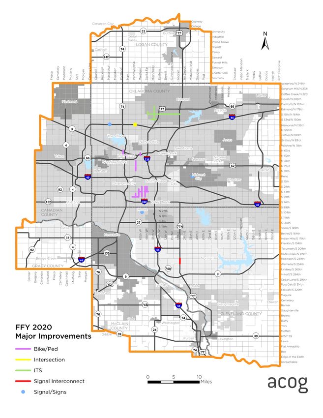
located within the OCARTS area. Figure 2 identifies the locations of the major improvements
reflected in the table.
STREET AND HIGHWAY ELEMENT FUNDING SOURCES
Several categories of federal funding are available for implementing the Street and Highway
Element of the TIP. The Moving Ahead for Progress in the 21st Century Act (MAP-21), enacted
in 2012, included provisions to make the Federal surface transportation more streamlined,
performance-based, and multimodal, and to address challenges facing the U.S. transportation
system, including improving safety, maintaining infrastructure condition, reducing traffic
congestion, improving efficiency of the system and freight movement, protecting the
environment, and reducing delays in project delivery.
On December 4, 2015, Public Law 114-94, the Fixing America’s Surface Transportation (FAST)
Act was signed into law. The FAST Act builds on the changes made by MAP-21. The FAST Act
funds surface transportation programs for federal fiscal years (FFY) 2016 through 2020. It is
the first transportation law enacted in a decade that provides long-term funding certainty for
surface transportation.
The law maintained (with modification) the core highway formula programs and added a new
National Highway Freight Program, as described below:
• National Highway Performance Program (NHPP)
– Created under MAP-21, this program combined the former National Highway System,
Interstate Maintenance, and Highway Bridge Programs
• Surface Transportation Block Grant Program (STBG)
– Name changed to add the words “Block Grant”
– Continues all prior STP eligibilities
– Transportation Alternatives Program eliminated and replaced with a set-aside of STBG
program funding
– Maintains Recreation Trails Program set-aside
11– Congestion Mitigation and Air Quality Improvement Program (CMAQ)
• Highway Safety Improvement Program (HSIP)
• Railway-Highway Crossings Program (set-aside from HSIP)
• National Highway Freight Program
– New program to improve the efficient movement of freight on the National Highway Freight
Network
Some of these funding sources may also be used for bicycle and pedestrian pathways, as
alternatives to vehicle travel, and some are “flexible,” meaning they can be used for eligible
transit activities. Funding apportionments under these programs are made available annually
to ODOT from the Federal Highway Administration for use throughout the state.
The FAST Act calls for urbanized areas with a population greater than 200,000 to receive a
formula-based suballocation of Surface Transportation Block Grant Program (STBG) funds,
including the set-aside for transportation alternatives projects. The amount of funding
received is based upon the population within the census-designated urbanized area.
Beginning with the 2000 Census and continuing with the 2010 Census, the U.S. Census
Bureau delineated two urbanized areas (UZAs) within the OCARTS TMA—the Oklahoma City
UZA and Norman UZA. Sec. 6016 of the FAST Act attributes the Norman UZA population to
the Oklahoma City UZA for highway funding purposes.
A one-year continuing resolution to the FAST Act was signed on October 1, 2020, extending
funding through September 30, 2021. A multi-year surface transportation bill, or a larger
infrastructure bill that includes surface transportation act reauthorization, is anticipated in
2021.
12OCARTS Area Projects Funded During FFY 2020
Local Government Projects
ESTIMATED ESTIMATED
PROJECT TIP ID/JP LENGTH FUNDING
PROJECT DESCRIPTION FEDERAL LOCAL TOTAL
SPONSOR NUMBER (MILES) SOURCE
SHARE SHARE
S Walker Ave, SW 44th St, & S Robinson Ave 10875/ STBG-UZA
Oklahoma City VAR 2,088,407 522,102 2,610,509
(Sidewalks) 34161(04) 80%/20%
10878/ STBG-UZA
Oklahoma City N Portland & NW 50th (Sidewalks) VAR 1,354,998 338,749 1,693,747
34162(04) 80%/20%
10879/ STBG-UZA
Oklahoma City S Pennsylvania Ave and SW 59th St (Sidewalks) VAR 1,122,846 280,712 1,403,558
34164(04) 80%/20%
S Blackwelder Ave & S Western Ave: SW 36th Ave to 10876/ STBG-UZA
Oklahoma City VAR 1,597,397 399,350 1,996,747
SW 59th (Sidewalks) 34165(04) 80%/20%
10808/ STBG-UZA
Edmond 15th St & Kelly Ave - Phase 3 (ITS) VAR 7,434,277 1,858,569 9,292,846
34166(04) 80%/20%
10825/ STBG-UZA
Oklahoma City N Classen Blvd: NW 50th to Classen Curve (Sidewalks) 0.53 433,952 108,488 542,440
34168(04) 80%/20%
S Western Ave, S Walker Ave, and S Robinson Curve 10877/ STBG-UZA
Oklahoma City VAR 1,569,853 392,463 1,962,316
(Sidewalks) 34169(04) 80%/20%
10852/ STBG-UZA
Oklahoma City N Pennsylvania Ave & Memorial Rd (Intersection) NA 488,458 112,114 600,572
34170(04) 80%/20%
10838/ STBG-UZA
Oklahoma City N Pennsylvania Ave: NW 36th St to Park Pl (Sidewalks) 1.94 1,049,837 262,459 1,312,296
34171(04) 80%/20%
STBG-UZA
COTPA EMBARK Fleet Expansion - two CNG Buses 10836 NA 748,329 356,041 1,104,370
68%/32%
10881/ STBG-UZA
Midwest City Signal Pedestrian Project VAR 853,373 0 853,373
33347(04) 100% Safety
10845/ STBG-UZA
Oklahoma City Citywide (Traffic Signal Vehicle Detection upgrades) VAR 436,720 0 436,720
34173(04) 100% Safety
10843/ STBG-UZA
Oklahoma City Citywide (Left Turn Signal Upgrades) VAR 436,720 0 436,720
34174(04) 100% Safety
12th Ave NE: Alameda to Robinson (Signal 10818/ STBG-UZA
Norman VAR 254,455 0 254,455
Interconnect) 32533(04) 100% Safety
STBG-UZA TOTALS 19,869,622 4,631,048 24,500,670
13OCARTS Area Projects Funded During FFY 2020
ODOT Projects
ESTIMATED ESTIMATED
JP LENGTH FUNDING
COUNTY PROJECT DESCRIPTION FEDERAL LOCAL OTHER TOTAL
NUMBER (MILES) SOURCE
SHARE SHARE
SH-4 OVER THE N. CANADIAN RV, & 2 O'FLOWS 1.92, 0 13,856,347
Canadian 04757(05) 0.340 STBG 11,085,078 2,771,269
2.13, & 2.26 MI NORTH OF SH-66
SH 152: ADD SHOULDERS & RESURFACE FROM US 81 0 2,342,984
Canadian IN UNION CITY E. 9.0 MI. TO CEMETERY RD. IN 27901(06) 0.500 TBD 1,874,387 468,597
MUSTANG UT FOR 27901(04)(09)
I-40: INTERCHANGE AT FRISCO ROAD, 4.5 MILES 4,393,634 17,097,371
Canadian 30715(04) 0.330 NHPP 12,703,737 0
WEST OF THE KILPATRICK TURNPIKE JUNCTION.
SH-9: FROM 72ND AVE EAST, EAST TO 108TH AVE 0 17,459,620
Cleveland EAST IN NORMAN (INCLUDES BRIDGE OVER 20266(11) 3.000 STBG 17,459,620 0
UNNAMED CREEK)
I-35 UNDER INDIAN HILLS ROAD, 7.39 MI NORTH OF 0 1,000,000
Cleveland 29106(09) 0.020 SSP 0 1,000,000
MCCLAIN C/L
SH-37 OVER UNNAMED CREEK, 5.3 MI EAST OF JCT I- 0 186,862
Cleveland 31257(06) 0.200 STBG 149,490 37,372
44 UT FOR 31257(04)
SH-9: FROM 108TH AVE EAST, EAST TO 156TH AVE 0 2,452,500
Cleveland 20266(15) 4.600 SSP 0 2,452,500
EAST (SOUTH) IN NORMAN (RW FOR 20266(14))
SH-9: FROM 108TH AVE EAST, EAST TO 156TH AVE 0 817,500
Cleveland 20266(16) 4.600 TBD 654,000 163,500
EAST (SOUTH) IN NORMAN (UT FOR 20266(14))
US-77: FROM 0.25 MI SOUTH OF MOFFATT RD (N. OF 0 13,131,375
Cleveland 20997(04) 3.220 STBG 10,505,100 2,626,275
LEXINGTON), NORTH 3.22 MI. (4 LANE UNDIVIDED)
SH-9: FROM EAST END OF PECAN CREEK BRIDGE, 0 1,684,050
Cleveland 23288(09) 5.550 TBD 0 1,684,050
EAST 5.55 MI TO SH-102 (RW FOR 23288(08))
SH-9: FROM EAST END OF PECAN CREEK BRIDGE, 0 561,350
Cleveland 23288(10) 5.550 TBD 449,080 112,270
EAST 5.55 MI TO SH-102 (UT FOR 23288(08))
I-35 UNDER INDIAN HILLS ROAD, 7.39 MI NORTH OF 0 115,638
Cleveland 29106(06) 0.020 SSP 0 115,638
MCCLAIN C/L (RW FOR 29106(05))
I-35 UNDER INDIAN HILLS ROAD, 7.39 MI NORTH OF 0 57,819
Cleveland 29106(07) 0.020 NHPP 52,037 5,782
MCCLAIN C/L (UT FOR 29106(05))
CIRB-226C (066) RB SH-19 EXT S 3.0 MI, ON EW-142.5 0 150,000
Grady 34262(05) NA TBD 120,000 30,000
AT NS-284 EXT EAST 1.0 MI
I-35/SH-9W RAMP MODIFICATION (RW FOR 0 4,036,600
McClain 19314(06) 0.200 TBD 2,018,300 2,018,300
19314(04))
0 924,700
McClain I-35/SH-9W RAMP MODIFICATION (UT FOR 19314(04)) 19314(07) 0.200 TBD 739,760 184,940
SH-76: FROM SH-130, NORTH 3.0 MI TO SH-37 (UT 0 1,861,297
McClain 29671(06) 3.000 TBD 1,489,038 372,259
FOR 29671(04))
14OCARTS Area Projects Funded During FFY 2020
ODOT Projects (Cont.)
ESTIMATED ESTIMATED
JP LENGTH FUNDING
COUNTY PROJECT DESCRIPTION FEDERAL LOCAL OTHER TOTAL
NUMBER (MILES) SOURCE
SHARE SHARE
I-35: SOUTHBOUND RAMP AT SH-74W, IN PURCELL
McClain 32802(05) 0.750 TBD 211,830 52,958 0 264,788
(R/W FOR 32802(04)
I-35: SOUTHBOUND RAMP AT SH-74W, IN PURCELL
McClain 32802(06) 0.750 TBD 211,830 52,958 0 264,788
(UT FOR 32802(04)
I-40: W.B. AND E.B. BRIDGES OVER CRUTCHO CREEK
Oklahoma 23310(04) 0.100 NHPP 13,475,597 40,426,790 0 53,902,387
& SE 15TH STREET 2.3 & 2.6 MILES EAST OF JCT. I-35
I-240 UNDER SH 77H (SOONER ROAD): 4.0 MILES E.
Oklahoma 27107(04) 0.200 TBD 0 4,880,128 0 4,880,128
OF I-35
I-40: E.B. AND W.B. BRIDGES OVER SOONER ROAD 3.1
Oklahoma 28854(04) 0.100 NHPP 7,753,073 23,259,219 0 31,012,292
MILES EAST OF I-35
I-35: NB & SB BRIDGES OVER 63RD STREET 5.0 MIS. N.
Oklahoma 29844(07) 0.100 NHPP 1,122,841 124,760 0 1,247,601
OF I-40 (UT FOR 29844(04))
I-44: DOWEL BAR RETROFIT AND DIAMOND
Oklahoma GRINDING FROM SW 74TH ST, NORTH TO THE 31006(04) 5.000 NHPP 6,729,316 6,729,316 0 13,458,632
OKLAHOMA RIVER
I-44: BRIDGE REHABILITATION OVER I-240, 1.3 MILES
Oklahoma NORTH OF THE CLEVELAND COUNTY LINE 31018(04) 0.250 NHPP 2,694,923 299,436 0 2,994,359
INCLUDING RAMP AND NB MAINLINE
I-44: NB AND SB BRIDGE REHABILITATION OVER
Oklahoma 31019(04) 0.410 NHPP 1,352,809 150,312 0 1,503,121
59TH ST, 0.75 MILES SOUTH OF THE SH-152 JCT
I-44; EB & WB SW 29TH OVER, APPROX. 4.00 MLS
Oklahoma 31924(04) 0.200 NHPP 1,007,348 111,928 0 1,119,275
NORTH OF CLEVELAND C/L
Oklahoma I-44: NB AND SB BRIDGES OVER OKLAHOMA RIVER 33081(04) 0.200 NHPP 2,498,910 2,498,910 0 4,997,820
I-44: EASTBOUND BRIDGE OVER INDEPENDENCE
Oklahoma AVENUE, 2.3 MILES NORTH OF THE I-240 33131(04) 0.400 NHPP 419,981 46,665 0 466,646
INTERCHANGE
SH-152: EB AND WB BRIDGES OVER BNSF RR, 2.5
Oklahoma 33242(04) 0.600 SSP 0 1,000,000 0 1,000,000
MILES EAST OF THE CANADIAN CL
TOTAL 96,778,085 93,676,132 4,393,634 194,847,850
15Figure 2: Major OCARTS Improvements for FFY 2020
16SURFACE TRANSPORTATION BLOCK GRANT PROGRAM – URBANIZED
AREA FUNDS (STBG-UZA)
As a Transportation Management Area, ACOG receives an annual distribution of Surface
Transportation Block Grant Program (STBG-UZA) funds according to the formula outlined in
the FAST Act. The amount of funding received is based on the combined populations of the
Oklahoma City and Norman Urbanized Areas. These are referred to as STBG-UZA funds.
Selection of STBG-UZA funded projects for the TIP is performed in accordance with the MPO-
adopted Surface Transportation Block Grant Program Procedures for the Oklahoma City
Urbanized Area Funds. STBG-UZA project requests are evaluated and prioritized in
accordance with the adopted Criteria and Process for Evaluation of STBG-UZA Projects as
part of the development (or update) of each TIP.
Beginning in the fall of 2017, ACOG’s member jurisdictions and staff identified a disconnect
between the projects that were being awarded in the TIP and the goals, objectives and
strategies identified in the Metropolitan Transportation Plan, Encompass 2040. After a year-
long revision of the Criteria and Process for Evaluation of STBG-UZA Projects under the
guidance of a consultant and a sub-committee made of up members of the ITTC and ITPC,
revisions were adopted by the ITPC on August 16, 2018. These revisions were made to reflect
the goals of Encompass 2040, the strategies of the Congestion Mitigation Process (CMP) and
member entity priorities. The goals and priorities of Encompass 2040 are: Economic Strength,
Safety and Security, Equity and Options, Healthy Communities, Connectivity, System
Performance, and System Preservation.
From these goals, ten evaluation criteria were created as a means of scoring projects
submitted for STBG-UZA funding. The evaluation criteria are as follows:
ENCOMPASS 2040
STBG-UZA SCORING CRITERIA
GOALS
Economic Strength Supports a regional activity center
Safety and Security Addresses safety at high crash severity locations
Provides options for Environmental Justice (EJ) areas or underserved
Equity and Options
communities
Healthy Communities Improves air and water quality
Integrates multiple transportation modes, connects to multiple communities, or
Connectivity
leverages other investments
Addresses congested based on volume/capacity ratio, congested/unreliable
System Performance
corridors, strategies that reduce travel delay
System Preservation Improves infrastructure condition
The categories of projects included in the evaluation process are:
• widening (including railroad/roadway grade separation)
• new construction
• intersection/safety improvements
• resurfacing, reconstruction, rehabilitation, restoration
17• bridge improvements
• transit, park-and-ride, high occupancy vehicle lanes
• independent bicycle and pedestrian facilities/projects
• carpool/vanpool administration, other
• safety projects (eligible for 100 percent federal funds)
In October 2009, the Intermodal Transportation Policy Committee updated the STBG-UZA
Procedures to allow all MPO-member local governments within the OCARTS area to apply for
the region’s STBG-UZA funds. Prior to this policy change, eligible applicants were restricted
to local governments located wholly or partially within the combined Oklahoma City and
Norman Urbanized Areas. Copies of both the STBG-UZA Procedures and the STBG-UZA
Evaluation Criteria are available on the ACOG website www.acogok.org.
SURFACE TRANSPORTATION BLOCK GRANT PROGRAM – URBANIZED
AREA SAFETY (STBG-UZA SAFETY) FUNDS
Up to 10 percent of the total STBG-UZA funds may be spent on the construction costs of
eligible safety improvements and may be funded with up to 100 percent federal funds. The
STBG-UZA Evaluation Criteria described above incorporates the MPO's policy for selecting
and funding safety projects. The 10 percent limit for any given year may be exceeded,
provided the cumulative total of all STBG-UZA funds apportioned to the urbanized area does
not exceed the 10 percent maximum.
The standard funding ratio for STBG funds is 80 percent federal. The remaining 20 percent is
to be provided by the state or local government sponsor. However, federal rules allow up to
10 percent of the total STBG-UZA funds to be spent at 100 percent of the project cost, with
no local match, for eligible safety projects defined in the law.
SURFACE TRANSPORTATION BLOCK GRANT PROGRAM SET ASIDES – TAP
AND RTP
The FAST Act eliminated the MAP-21 Transportation Alternatives Program (TAP) and
replaced it with a set-aside of STBG Program funding for transportation alternatives. These
set-aside funds include all projects and activities that were previously eligible under TAP,
encompassing a variety of smaller-scale transportation projects such as pedestrian and
bicycle projects, recreational trails, and safe routes to school projects. Also eligible are
community projects such as historic preservation and vegetation management, and
environmental mitigation related to stormwater and habitat connectivity.
Similar to the previous TAP program, the FAST Act requires all transportation alternative
projects to be funded through a competitive process, and metropolitan areas over 200,000
population receive a suballocation of the set-aside funds based on their urbanized area
population. The FAST Act newly requires States and MPOs to report annually to the US
Department of Transportation (USDOT) on project applications and projects that are
awarded. The USDOT will make these reports available to the public.
This TIP includes a transportation alternatives line item for each year to reflect the total
federal funds that will be authorized for successful projects. These projects may be funded
with up to 80 percent federal funds and at least a 20 percent local match.
The Recreational Trails Program (RTP) set-aside is administered at the state level by the
Oklahoma Tourism and Recreation Department, which maintains an annual application cycle
and competitive project selection process.
18FISCAL CONSTRAINT OF THE FFY 2022 – 2025 URBANIZED AREA FUNDS
This TIP was prepared based on an estimated amount of funds available to the OCARTS area
over the TIP timeframe for the combined Oklahoma City and Norman urbanized areas. To
ensure that the region’s STBG-UZA projects are financially constrained, an estimated
apportionment for the Oklahoma City Urbanized Area was developed in consultation with the
Programs Division of the Oklahoma Department of Transportation (ODOT). The estimate is
based on the STBG-UZA apportionment that was received in FFY 2016 under MAP-21 and was
increased each year based upon annual funding increases anticipated under the FAST Act.
Federal law requires cost estimates for TIP projects include an inflation factor to reflect year-
of-expenditure dollars. Therefore, the STBG-UZA project estimates included in this TIP reflect
the ODOT inflation factors of 3.0% for FFY 2022, 6.0% for FFY 2023, 9.0% for FFY 2024, and
12.0% for FFY 2025.
The STBG-UZA Procedures for the Oklahoma City Urbanized Area Funds call for 90 percent
of the estimated funds to be used when preparing a TIP. This is intended to avoid a shortage
of funds in case the actual federal STBG-UZA funds are less than the estimate used to
develop the TIP or other unforeseen events. The estimate serves as the planning cap for
STBG-UZA funded projects for each year of the TIP, including future amendments. As final
funding figures are provided, and/or additional obligation authority is received, the figures
will be updated. The table below reflects the estimated funds anticipated for each year of the
TIP.
% ESTIMATED 90% OF ESTIMATED STBG-UZA STBG-UZA SAFETY
FFY
INCREASE APPORTIONMENT APPORTIONMENT (80%/20%) (100%)
2022 2.25% 23,804,441 21,423,997 19,281,597 2,142,400
2023 2.39% 24,373,367 21,936,031 19,742,427 2,193,603
2024 2.39% 24,955,891 22,460,302 20,214,271 2,246,030
2025 2.39% 25,552,337 22,997,103 20,697,393 2,299,710
Each of the Local Government Project lists also reflects a line item for Congestion Mitigation/
Air Quality (CMAQ) funds that will be spent within the OCARTS area. Each year, the
Oklahoma Department of Transportation provides the MPO with $700,000 in CMAQ funds to
assist with programs to enhance the region’s air quality. A portion of the funds is provided to
the area’s transit operators and the remainder is used by ACOG to administer its air quality
public education, Air Quality Awareness grants and public fleet conversion programs.
FFY 2022 – 2025 STREET AND HIGHWAY ELEMENT PROJECTS
The following pages describe the street and highway projects proposed for implementation
within the OCARTS area during this TIP time frame.
Projects are presented by federal fiscal year and include lists of local government-sponsored
projects followed by state-sponsored projects within the OCARTS area. The state projects
were selected in cooperation with ODOT and are generally located on the State Highway
System (interstates, state highways, and U.S. highways). Each project is identified by location,
project type, federal funding source, and the source of matching funds.
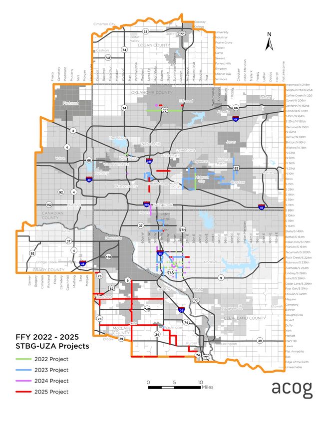
Figure 3, at the end of this chapter, reflects the general locations of the local government
sponsored Street and Highway Element improvements listed in this TIP for FFY 2022-2025.
For more information regarding the FFY 2022 – 2025 Street and Highway Element of the TIP,
please see ACOG’s eTIP at https://etracker.acogok.org/default.asp.
19STREET ELEMENT
Local Government Projects
FFY 2022
ESTIMATED ESTIMATED
PROJECT TIP ID/JP LENGTH FUNDING
PROJECT DESCRIPTION FEDERAL LOCAL TOTAL
SPONSOR NUMBER (MILES) SOURCE
SHARE SHARE
STBG-UZA
Norman Traffic Management Center (ITS) 11241 NA 2,792,114 698,028 3,490,142
80%/20%
Porter Ave: from W Robinson St to Alameda St STBG-UZA
Norman 11231 1.06 2,855,610 713,902 3,569,512
(Reconstruction) 80%/20%
STBG-UZA
Norman Norman Bus Replacement - (One 35' CNG Bus) (Transit) 11220 NA 491,633 122,908 614,541
80%/20%
STBG-UZA
Edmond Edmond Rd: from I-35 west to City Limits (Bike/Ped)* 11033 5.40 2,142,400 1,917,233 4,059,633
53%/47%
STBG-UZA
Midwest City Midwest Blvd: from SE 29th St to NE 10th St (Resurfacing) 10859 3.00 3,886,793 971,698 4,858,490
80%/20%
James Garner Ave: from W Robinson St to Acres St (New STBG-UZA
Norman 11222 0.55 4,825,733 1,206,433 6,032,166
Cons./Inters.) 80%/20%
STBG-UZA
COTPA EMBARK Fleet Replacement (Two 40' CNG buses) (Transit) 11201 NA 895,899 224,068 1,119,967
80%/20%
STBG-UZA
Oklahoma City NW Expressway & east of Lake Hefner Prkw (Inters.)* 11262 NA 1,391,415 729,233 2,120,648
66%34%
STBG-UZA
Midwest City City Wide (Phase 4) (Signals) 11243 VAR 786,920 0 786,920
100% Safety
SW 19th St: from S Santa Fe to S Broadway Ave (Video STBG-UZA
Moore 11252 VAR 793,818 0 793,818
Detection) 100% Safety
STBG-UZA
Norman City Wide (Phase 2) (Emergency Preemption)* 11219 VAR 561,662 20,751 582,413
96%4%
FFY 2022 STBG-UZA TOTALS 21,423,997 6,604,253 28,028,250
*Project has been overmatched by sponsor
20HIGHWAY ELEMENT
ODOT Projects
FFY 2022
JP FEDERAL STATE
COUNTY PROJECT DESCRIPTION WORK TYPE LENGTH TOTAL
NUMBER SHARE SHARE
GRADE, DRAIN,
Canadian 04757(04) SH 4: FR SH-66 IN YUKON NORTH TO WAGNER. BRIDGE & 3 6,437,500 6,437,500 12,875,000
SURFACE
I-35: AT INDIAN HILLS ROAD, 7.39 MI NORTH OF
Cleveland 29106(06) RIGHT OF WAY NA 0 115,360 115,360
MCCLAIN C/L (RW FOR 29106(05)
I-35: AT INDIAN HILLS ROAD, 7.39 MI NORTH OF
Cleveland 29106(07) UTILITIES NA 45,320 11,330 56,650
MCCLAIN C/L (UT FOR 29106(05)
I-44: FROM JUST SOUTH OF 89TH STREET, NORTH TO
Cleveland 30391(05) RIGHT OF WAY NA 0 1,030,000 1,030,000
0.5 MI NORTH OF 89TH STREET IN OKC (RW FOR (04)
I-44: FROM JUST SOUTH OF 89TH STREET, NORTH TO
Cleveland 30391(06) UTILITIES NA 688,040 172,010 860,050
0.5 MI NORTH OF 89TH STREET IN OKC (UT FOR (04)
SH-105: FROM JCT OF SH-33, EAST 6.5 MILES TO 1,000
Logan 31002(05) RIGHT OF WAY NA 2,817,750 2,817,750 5,635,501
FT EAST OF HENNEY RD (ROW FOR 31002(04))
SH-105: FROM JCT OF SH-33, EAST 6.5 MILES TO 1,000
Logan 31002(06) UTILITIES NA 1,701,291 425,323 2,126,614
FT EAST OF HENNEY RD (UT FOR 31002(04))
McClain 19314(06) I-35: AT SH-9W INTERCHANGE (RW FOR 19314(04)) RIGHT OF WAY NA 0 4,032,450 4,032,450
McClain 19314(07) I-35: AT SH-9W INTERCHANGE (UT FOR 19314(04)) UTILITIES NA 741,600 185,400 927,000
GRADE, DRAIN &
McClain 29671(04) SH-76: FROM SH-130, NORTH 3.0 MI TO SH-37 3 7,779,118 1,944,780 9,723,898
SURFACE
SH-24: BEGIN 3.0 MILE WEST OF JCT SH-74, EXTEND
McClain 31058(05) RIGHT OF WAY NA 0 327,000 327,000
NORTH 3.05 MI (RW FOR 31058(04)
SH-24: BEGIN 3.0 MILE WEST OF JCT SH-74, EXTEND
McClain 31058(06) UTILITIES NA 131,840 32,960 164,800
NORTH 3.05 MI (UT FOR 31058(04)
I-35: NB & SB BRIDGES OVER 63RD STREET 5.0 MIS. N. BRIDGE &
Oklahoma 29844(04) 0.1 19,518,500 19,518,500 39,037,000
OF I-40. APPROACHES
I-35: FROM MEMORIAL RD TO SH-66 IN EDMOND (RW
Oklahoma 32425(06) RIGHT OF WAY NA 84,732 21,183 105,915
FOR 04)
I-35: FROM MEMORIAL RD TO SH-66 IN EDMOND (UT
Oklahoma 32425(07) UTILITIES NA 84,732 21,183 105,915
FOR 05)
FFY 2022 ODOT TOTAL 40,030,424 37,092,729 77,123,153
21STREET ELEMENT
Local Government Projects
FFY 2023
ESTIMATED ESTIMATED
PROJECT TIP ID/JP LENGTH FUNDING
PROJECT DESCRIPTION FEDERAL LOCAL TOTAL
SPONSOR NUMBER (MILES) SOURCE
SHARE SHARE
Transit Bus Replacement (One 35' low-floor CNG bus) STBG-UZA
Norman 11247 NA 505,953 126,488 632,441
(Transit) 80%/20%
Classen Blvd: from N Sheridan Ave to NW 10th St* STBG-UZA
Oklahoma City 11258 0.84 2,193,603 928,105 3,121,708
(Bike/Ped) 70%/30%
NE 12th St: from E of I-35 Service Rd to Eastern Ave STBG-UZA
Moore 11216 1.00 7,166,132 1,791,533 8,957,665
(Reconstruction) 80%/20%
STBG-UZA
Oklahoma City N May Ave & NW Expressway (Bridge) 11259 NA 6,359,763 1,589,941 7,949,703
80%/20%
STBG-UZA
Moore N Eastern Ave: SE 4th St to NE 12th St (Reconstruction) 11034 1.00 1,751,123 437,781 2,188,904
80%/20%
STBG-UZA
Norman Jenkins Ave: from W Lindsey St to Imhoff Rd (Widening)* 11234 1.00 1,765,853 11,388,876 13,154,729
13%/87%
STBG-UZA
Moore SW 19th St: from S Santa Fe Ave to S Eastern Ave (Striping) 11253 2.00 324,090 0 324,090
100% Safety
STBG-UZA
Midwest City City Wide (Phase 5) (Striping) 10882 VAR 318,000 0 318,000
100% Safety
STBG-UZA
Norman City Wide (Phase 9) (Striping) 11240 VAR 319,109 0 319,109
100% Safety
STBG-UZA
Norman City Wide (Phase 7) (Striping) 11239 VAR 318,590 0 318,590
100% Safety
STBG-UZA
Midwest City City Wide (Phase 5) (Signals) 11242 VAR 788,640 0 788,640
100% Safety
STBG-UZA
COTPA EMBARK Streetcar Clearance Lines (Striping/Signage) 11205 VAR 34,980 0 34,980
100% Safety
STBG-UZA
Choctaw Henney Rd: from NE 50th St to SE 15th St (Striping) 11255 5.00 58,657 0 58,657
100% Safety
STBG-UZA
Choctaw Harper Rd: from NE 23rd St to NE 10th St (Striping) 11254 1.00 12,155 0 12,155
100% Safety
McClain STBG-UZA
Eastern Ave near Washington School exit drive (Guardrail)* 10834 NA 19,382 15,348 34,730
County 56%/44%
FFY 2023 STBG-UZA TOTALS 21,936,030 16,278,071 38,214,101
*Project has been overmatched by sponsor. All projects are locked and capped at the revised estimates.
22You can also read