Under the Big Sky e-Letter July 2020 - National Weather Service Glasgow, MT Photo Credit: Cory Mottice, Thunderstorm N. Fort Peck, MT on July 1 ...
←
→
Page content transcription
If your browser does not render page correctly, please read the page content below
Under the Big Sky
       e-Letter
       July 2020

                           Photo Credit: Cory Mottice, Thunder-
                           storm N. Fort Peck, MT on July 1, 2020.

National Weather Service
     Glasgow, MT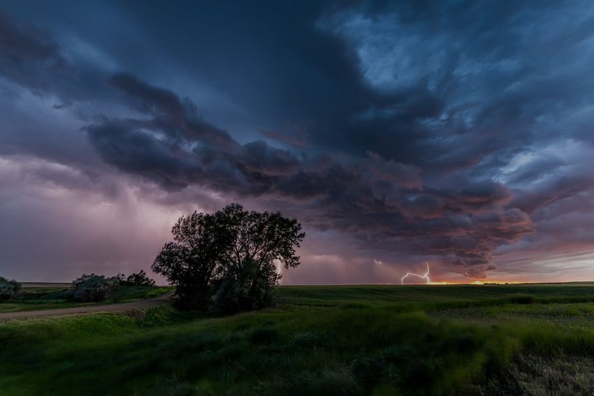
From the MIC (Meteorologist-In-Charge):
Hi everyone!
I can’t believe I have now been in Glasgow for 19.5 years.
As an Air Force brat, I was used to moving every few
years. We moved here to be close to family in North Da-
kota, and my two young sons not even in grade school
yet. They are now young adults who have Montana deep
in their hearts. I heard a few years ago that “Montana is
full of friends, you just haven’t met them all yet.” That
is certainly true. I love running into our weather spotters
in gas stations or stores, at sports events, etc. I may not
always put a name with the face, but don’t hesitate to
say hi if you run into me somewhere! After transitioning
to the supervisor role from the outreach role 5 years ago
I realize what I miss most is meeting all the people I did
conducting Skywarn training.
In my time here, we’ve issued just over 3000 severe thunderstorm and tornado warnings. I
can’t even imagine how many reports that includes from all the weather spotters and the
public in that time, but I would easily guess that is over 10,000 reports of severe weather.
Throw in winter weather and high winds, and rainfall and flood reports, and we’re likely over
25,000 reports in the last 20 years. We can’t do what we do without you! Social media has
organically taken roles of sharing information, but we can’t be on all sites gathering all data,
so your reports via phone, email, or tweets and posts on our Facebook pages are hugely wel-
come and encouraged. And, thank you to those who send our editor, Rich Maliawco, feed-
back from time to time. He puts a lot of time and effort into the newsletter to provide you
with information you’ll find informative.
Lastly, our staff. In the time here, I’ve worked with over 70 people (we currently have 23 em-
ployees). We even had 5 that left, and returned, even though they didn’t have roots in this
area, they just loved it more than urban areas they had gone to. Many of us now have roots
here. From kids, to marrying someone locally, I can say without a doubt for our staff that the
“middle of nowhere” has been a great place to be.
~Let the gentle breezes blow,
Tanja Fransen, Meteorologist in Charge, NWS Glasgow, MT
Welcome to the July 2020 Edition of the NWS Glasgow Under the Big Sky E-Letter!
Each month we issue the latest Under the Big Sky newsletter in which we provide you with
important weather, climate, and water information. Routinely included are the latest three
month outlooks, the latest U.S. Drought Monitor, COOP precipitation reports, summaries of
important weather events, trivia, and more. In addition, we also try to shed light on local
office NWS Glasgow happenings from time to time , as well as keep you up to date on any
staffing changes.
We hope that you find these regularly issued newsletters both fun and informative and we
thank you for allowing us the opportunity to serve!
As always, we continue to welcome any feedback that you may have so feel free to share
with us what you think!
A Peak Inside:
Boating Safety...Page 1
30-Day Precip & temps/CoCoRaHS...Page 2
Hydrologic Summary...Page 3
CPC Outlook/Drought Monitor...Page 4
Climate Highlights...Page 5
Monthly COOP Precipitation...Page 6
Monthly Trivia...Page 7
Boating Safety Awareness
Boating and related recreational activities are commonplace during the warm season
months out at Fort Peck Lake. However, weather can often impact conditions out on the
open waters. Whether it’s breezy conditions or severe thunderstorms, NWS Glasgow strives
to help you and those you care about stay safe all summer long.
Monitor the forecast for Fort Peck Lake.
NWS Glasgow will issue a Lake Wind Advisory when sustained wind speeds will be great-
er than 20 mph long enough to create impacts (3 hours or more), or when any gust in ex-
cess of 30 mph is expected in the absence of convection.
Have a life jacket and “wear it!” Approximately 85 percent of those who drown while
out boating did not have on a life jacket. This strategy can save a life.
Use your mobile phone, or NOAA Weather Radio to get up to the minute warning infor-
mation should thunderstorms approach you.
If you see storms approaching, head for shore quickly and take shelter. Thunderstorms
produce dangerous lightning which can result in a fire or loss of electronics, along with
other safety risks.
A much more comprehensive resource for boating safety under a variety of weather haz-
ards is available here.
Figure 1: Boating safety campaign graphic.
Background Photo Credit: Craig Paju
1
We Need New CoCoRaHS Observers:                                       30 Day Percent of Normal Precipitation (Montana)

NWS Glasgow is looking for
new CoCoRaHS volunteers.
Here is how to join:

Check out the CoCoRaHS
webpage and tap the join
button on the upper right. It is as easy as that!

CoCoRaHS is a grassroots organization with a network
of dedicated observers who report daily precipitation                  Figure 3: 30-day percent of normal precipitation across
                                                                       Montana.
such as rain, hail, or snow from all across the country.
The data are used by meteorologists, insurance adjust-
ers, mosquito control, and even by those in academia.

Participating in the CoCoRaHS program is a great way
to make a difference in your community. And the best
part is that you only need a couple of things to get
started such as a 4 inch rain gauge and a ruler or yard-
stick. Why not give it a try today?

                                                                      Figure 4: 30-day temperature anomalies across Montana.

                                                                      Summary: Northeast Montana specifically has
                                                                      seen near or above normal precipitation over the
                                                                      last 30 days. This is generally true throughout Big
                                                                      Sky Country. However, there are small patches of
                                                                      abnormally dry conditions. Southwest Montana
                                                                      though is where it has been considerably drier
                                                                      than normal. Temperatures have generally trended
                                                                      near or a little below normal, though southeast
                                                                      portions of the state have been somewhat warmer
                                                                      than average.

Figure 2: CoCoRaHS observations reported morning of 7/8 follow-
ing the squall line event across NE Montana. Thank you for your
reports!
                                                                  2
Hydrologic Summary (June 2020) by Greg Forrester, Lead Forecaster at NWS Glasgow:

It was a slightly warmer than normal month for temperatures over Northeast Montana. Temperatures av-
eraged between near normal and 3 degrees above normal. Glasgow averaged 69.9 degrees which was 1.9
degrees above normal.
Precipitation was highly variable across the region as most of it came in thunderstorms. The dry spots
were Sidney 2S with 1.07 inches, Sidney with 1.25 inches, and Culbertson with 1.35 inches. The wet spots
were Glasgow 46SW with 6.99 inches, Mosby with 5.03 inches, and Hinsdale 21SW with 3.76 inches.
Glasgow had 2.17 inches of precipitation which was 95 percent of normal.
Heavy rain on June 29th did produce minor flooding on small streams across western Garfield and south-
west Valley Counties.
Stream flow on the Milk, Missouri, Yellowstone, and Poplar Rivers was near normal for the entire month.
The Fort Peck Reservoir elevation rose to 2239.6 feet during the month. The reservoir was at 87 percent of
capacity and 108 percent of the mean pool.

                                                                           Background Photo Credit: Craig Paju

                                                    3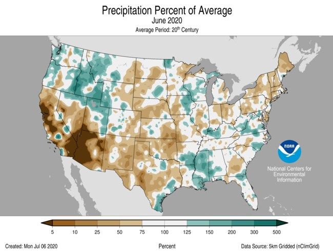
CPC Three Month Outlook:                                          U.S. Drought Monitor:
The Climate Prediction Center released its three                  The latest U.S. Drought Monitor was released on
month outlook for temperature and precipitation                   Thursday July 16, 2020. As of that time, areas of ab-
for August 2020 through October 2020 on July 16,                  normally dry conditions were present across much of
2020. The outlook calls for above normal tempera-                 north central and eastern Montana. Moderate drought
tures to persist over the three month period across               was present across portions of southeast Montana
the state. Meanwhile, equal chances for average,                  with conditions turning to severe drought in south-
below average, and above average precipitation ex-                western Montana.
ist across western and central Montana. Above nor-
mal precipitation is favored in the eastern part of
the state. The latest outlook in full detail is always
available here. In addition, you can check out the
Climate Prediction Center Interactive site! You can
zoom in on our area, and navigate to see the climate
outlook for your specific location. The pie charts on
the left hand side can be particularly useful for as-
sessing the outlook at your specific location.

Figure 5: Climate Prediction Center three month temperature
(top) and precipitation (bottom) outlook for August 2020
through October 2020.

                                                                      Figure 6: U.S. Drought Monitor updated July 16, 2020.

                                                              4
U.S. & Global Climate Highlights (June): The U.S.                             Local Climate Graphs:
& Global climate highlights for May 2020 have been re-
leased. A few points for you to take home are provided
below.                                                                      Glasgow, MT (June 2020)

   Figure 7: June 2020 Percent of Average Precipitation (U.S.).

U.S. Highlights for June 2020

1) The contiguous U.S. average temperature for June
   2020 was 70.3 °F, in the middle third of the 126 year              Figure 8: June 2020 Glasgow, MT Climate Graphs.

   record.

2) The average June precipitation total for the contigu-
   ous U.S. came in at 2.72 inches. This ranks within the                       Links You May Like:
   driest third of the existing period of record.                                    ENSO Update

Global Highlights for June 2020                                               Hottest Day of the Year?
                                                                       June 2020 tied as Earth’s 3rd Hottest
1) The June 2020 global land and ocean surface tem-
                                                                            NOAA Cloud & Data Strategy
   perature tied with the third highest in the 141 year
   period of record.                                                    NOAA’s Climate Risk Areas Initiative

2) The June 2020 global ocean only surface tempera-
   ture was 1.39 °F. This was the third highest for June
   as well within the 141 year period of record.

                                                                  5
COOP Precipitation Data (*Preliminary* June 2020)

Station Precipitation    Location                  Station Precipitation    Location
   BAYM8              M              Baylor          MDCM8               M        Medicine Lake 3 SE
   BRDM8            2.93           Bredette          MLDM8               M               Mildred 5 N
   BTNM8              M      Brockton 17 N           MSBM8             5.03             Mosby 4 ENE
   BKNM8            3.11      Brockton 20 S          OPNM8               M              Opheim 10 N
   BKYM8            3.38 Brockway 3 WSW              OPMM8             3.52           Opheim 12 SSE
   BRSM8              M            Brusette           PTYM8            2.74              Plentywood
    CLLM8           1.68     Carlyle 13 NW           PTWM8             3.58         Plentywood 1 NE
   CIRM8             2.52             Circle         POGM8             2.17           Port of Morgan
  CHNM8              2.20           Cohagen           RAYM8              M Raymond Border Station
    COM8             2.44     Cohagen 22 SE           SAOM8            2.99              Saco 1 NNW
  CNTM8              3.27      Content 3 SSE          SMIM8            2.87                 St. Marie
  CULM8              1.35         Culbertson          SAVM8            2.60                    Savage
  DSNM8                M        Dodson 11 N           SCOM8            3.24             Scobey 4 NW
   FLTM8             3.41   Flatwillow 4 ENE          SDYM8            1.25                    Sidney
   FPKM8             1.98       Fort Peck PP           SIDM8           1.07                 Sidney 2S
  GLAM8              1.71    Glasgow 14 NW            TERM8            1.69                     Terry
 GGWM8               2.17      Glasgow WFO            TYNM8              M             Terry 21 NNW
  GGSM8              6.99    Glasgow 46 SW             VIDM8           2.91                 Vida 6 NE
 GNDM8               1.42    Glendive WTP            WSBM8             2.54                   Westby
  HRBM8                M               Harb          WTRM8             2.32              Whitewater
  HINM8              3.17    Hinsdale 4 SW            WHIM8              M         Whitewater 18 NE
  HNSM8              3.76   Hinsdale 21 SW           WBXM8             2.01               Wibaux 2 E
 HOMM8               1.48   Homestead 5 SE           WTTM8               M                    Winnett
  HOYM8              1.46              Hoyt          WNEM8             3.27           Winnett 6 NNE
  JORM8                M             Jordan          WNTM8               M             Winnett 8 ESE
  LNDM8              1.87           Lindsay           WITM8            3.73           Winnett 12 SW
 MLAM8               2.54             Malta           WLFM8            3.21                Wolf Point
  MLTM8              3.05        Malta 7 E            ZRTM8            3.40                  Zortman
 MTAM8               3.02       Malta 35 S

                                               6
Monthly Trivia:
Last time we asked…
Why do meteorologists not like reports of marble sized hail?
Answer: Marbles come in a variety of different sizes. The main issue
with reports of marble sized hail is that it then becomes difficult to un-
derstand the size that you are describing. Using standardized objects
such as coins or sporting balls allows us to have an easy object to com-
pare the size of the hail too. When someone reports that hail is the size
of golf balls, universally people are able to understand what that means.
If you visualize hail the size of marbles; however, each individual may
have a different construct of what that means.

                                                                             Figure 10: Chart of standard hail sizes
                                                                             for reporting purposes (typically com-
                                                                             pared with a coin or sporting ball, etc.).

        Figure 9: Photo of marbles showing inconsistent sizes.

     New Question: As thunderstorm season ages in the late summer, fire weather concerns begin to
     ramp up, especially as area fuels dry, and warm and breezy environments become present. Dry thun-
derstorms also contribute to the risk for new fire starts. This month we ask: What exactly is a dry thunder-
storm?

Did You Know?:
One of the questions we often get from the public is, “I had damage to my roof, but I’m not sure when it
happened, it was sometime between March and May…” or “Some of my crops had hail damage that we did-
n’t notice until we started harvesting, was there hail in my area this summer?” Every storm report we re-
ceive from the public, trained weather spotters, and observational equipment is entered into a program
called Storm Data that is managed by the NOAA/NWS National Center for Environmental Information (NCEI).
They make that information publicly available on this website:
http://www.ncdc.noaa.gov/stormevents/
There are large gaps in the data prior to 1995, which is when the NWS modernized and created larger fore-
cast offices. But, the data for the past 25 years is fairly accurate based on the reports that we received.

Find us on Facebook, Twitter and YouTube! No account needed:
         Facebook.com/NWSGlasgow               Twitter.com/NWSGlasgow    YouTube.com/NWSGlasgow

                                                                 7
You can also read