Using Engineering With Nature (EWN) principles to manage erosion of watersheds damaged by large scale wildfires
←
→
Page content transcription
If your browser does not render page correctly, please read the page content below
Integrated Environmental Assessment and Management — Volume 00, Number 00—pp. 1–9
Received: 6 January 2021   |   Returned for Revision: 18 March 2021   |   Accepted: 12 May 2021                                            1

      Special Series

Using Engineering With Nature® (EWN®) principles to manage
erosion of watersheds damaged by large‐scale wildfires
Christopher P. Haring,1 Garrett L. Altmann,2 Burton C. Suedel,3 and Stephen W. Brown4
  1
   US Army Engineer Research and Development Center, Rock Island, Illinois, USA
  2
   Santa Clara Pueblo, Forestry Department, Espanola, New Mexico, USA
  3
   US Army Engineer Research and Development Center, Vicksburg, Mississippi, USA
  4
   US Army Corps of Engineers‐Albuquerque District, Albuquerque, New Mexico, USA

EDITOR’S NOTE:
   This article is part of the special series “Ecological consequences of wildfires.” The series documents the impacts of large‐scale
wildfires in many areas of the globe on biodiversity and ecosystem condition in both terrestrial and aquatic ecosystems, the
capacity for systems to recover, and management practices needed to prevent such destruction in the future.

      Abstract
        The US Army Corps of Engineers (USACE) manages hundreds of reservoirs and thousands of miles of navigation channels
      that provide invaluable flood control, commercial transport of materials, water supply, recreation, and stream flow regulation.
      This capability is being threatened by the continued occurrence of large‐scale wildfires across the western United States. The
      wildfires damage watersheds in part by denuding landscapes, reducing infiltration rates, and increasing runoff rates, thereby
      dramatically increasing the potential for the erosion of denuded slopes, destabilizing stream channels, increasing the infilling
      potential of reservoirs and, hence, reducing their capacity. The increased erosion rates highlight the need to develop
      innovative solutions to reduce erosion of watersheds laid bare after wildfires engulf the area. The Santa Clara Pueblo in
      northern New Mexico extends from the top of the eastern Jemez Mountains to the floodplains of the Rio Grande River. The
      Pueblo designed and constructed thousands of structures built from natural materials, consistent with Engineering With
      Nature (EWN) principles for erosion control incorporating low‐cost and readily available materials such as logs, mulch,
      vegetation, and local rock to stabilize highly erodible parts of the watershed. The watersheds where these natural structures
      were constructed were monitored after construction to assess their effectiveness, guiding a series of recommendations for
      broader implementation. As part of a continued emphasis on updating USACE engineering guidance, research, and de-
      velopment, funding has been focused on developing sustainable and resilient project designs using natural materials like
      those implemented by the Santa Clara Pueblo. This paper focuses on the innovative EWN‐based watershed stabilization
      practices that were implemented in the upper section of this wildfire affected canyon and tributary streams. Recom-
      mendations for future implementation based on lessons learned from this project are also provided. Integr Environ Assess
      Manag 2021;00:1–9. Published 2021. This article is a US Government work and is in the public domain in the USA.

      KEYWORDS: Equity, Las Conchas Wildfire, Nature‐based solutions, Reservoir, Santa Clara Pueblo

INTRODUCTION                                                                    continued occurrence of large‐scale wildfires across the
   The US Army Corps of Engineers (USACE) manages                               western United States. The wildfires damage watersheds in
hundreds of reservoirs and thousands of miles of navigation                     part by denuding landscapes and destabilizing stream net-
channels that provide invaluable flood control, commercial                       works, thereby dramatically increasing the potential for
transport of materials, water supply, recreation, and stream                    erosion of denuded slopes, hence increasing the infilling
flow regulation. This capability is being threatened by the                      potential of reservoirs and reducing their capacity. The re-
                                                                                duced reservoir capacity decreases the availability of
                                                                                drinking water and increases the management costs of
  This article contains online‐only Supporting Information.                     having to dredge the reservoirs to restore that capacity. The
  Correspondence Burton C. Suedel, US Army Engineer Research and                increased erosion rates highlight the need to develop in-
  Development Center, Vicksburg, MS, USA.                                       novative solutions to reduce erosion of watersheds, laid
  Email: burton.suedel@usace.army.mil
                                                                                bare after wildfires engulfed the area, and to reduce threats
  Published 18 May 2021 on wileyonlinelibrary.com/journal/ieam.
                                                                                to mission capability.

Integr Environ Assess Manag 2021:1–9                           DOI: 10.1002/ieam.4453                                         Published 2021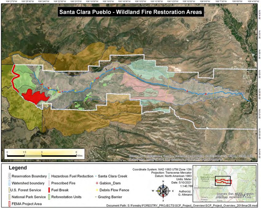
2                                                                             Integr Environ Assess Manag 00, 2021—HARING    ET AL.

   In 2011, the Las Conchas Wildfire burned more than               among racial groups), time (e.g., present vs. future gen-
156 000 acres and ranked as the second largest fire in New          erations), or space (e.g., upstream vs. downstream; Nelson
Mexico history. During the Las Conchas Wildfire, the Santa          et al., 2020). Inequities may also exist in the process of
Clara Canyon suffered a near total burn, which drastically         prioritizing, designing, and managing water resource proj-
changed the natural canyon environment, stream networks,           ects. In addition to reducing USACE capability, the sub-
and sediment stability of the canyon. The effects of the near      stantially increased erosion of surface soils post‐wildfire
total burn changed a 1% rain (100‐year) event to a 400%            served as an immediate threat to Santa Clara Pueblo infra-
increase in peak flow conditions when compared with pre‐            structure and severely disrupted the community's cultural
fire conditions.                                                    and religious connections to their land. The lands affected
   The result of the Las Conchas Wildfire was a starkly de-         by fire serve the Santa Clara People as a church for spiritual
nuded landscape that greatly increased the risk of erosion         sanctuary; pharmacy for medicinal plant gathering; super-
caused by surface runoff after storm events the design and         market for produce, fish, and game harvesting; and biology.
implementation of soil erosion treatments to mitigate the          Establishing a visceral connection to this landscape serves
enhanced risk. Various treatment options were considered,          as a foundation for Santa Clara cultural identification. The
based in part on known effectiveness of previous strategies        inability to partake of those traditional lifeways has deprived
implemented elsewhere. The effectiveness of treatments to          an entire generation of youth of that connection, which is
mitigate soil erosion after large‐scale wildfires have been         the foundation of Santa Clara Pueblo culture.
reported previously in the published literature, although             Santa Clara Pueblo is a federally recognized tribe of Na-
documentation of actual field treatment applications re-            tive American people located along the Rio Grande River in
mains a pressing need. A meta‐analysis of published post‐          northern New Mexico, USA. The Santa Clara Pueblo Indian
wildfire cover‐based, barrier, seeding, and chemical soil           Reservation encompasses 90 square miles of tribal land and
erosion mitigation treatments was performed to assess their        is home to 3500 residents who, since time immemorial, have
effectiveness (Girona‐García et al., 2021; Robichaud et al.,       relied on these lands for food, medicine, recreation, and
2000). The results indicated that all four treatment types         spiritual sanctuary (Altmann, 2021).
significantly reduced post‐fire soil erosion, but only the              Infrastructure managers require guidance on the inclusion
cover and barrier treatments substantially reduced post‐fire        of social equity in decision making associated with water
runoff. Results also indicated that overall treatment effec-       resource projects and how equity consideration is different
tiveness was greatest shortly after fires at severely burned        for conventional and nature based infrastructure solutions.
sites. The authors concluded that the application of the           In this paper, we demonstrate how equity was successfully
studied post‐fire erosion mitigation treatments were pre-           addressed using a collaborative approach that, from the
ferred over doing nothing, especially in areas where soil          outset, included input from the Santa Clara Pueblo in the
erosion was high, yet treatment results after larger scale         decision‐making process of designing and implementing
fires were seldom reported (Girona‐García et al., 2021;             NbS for watershed erosion management. The objective of
Robichaud et al., 2000).                                           this short communication is to provide information to help
   Guidelines for restoring ecosystems after wildfires have         watershed infrastructure managers understand the im-
identified several mitigation treatments that have been ap-         portance of equity in decision making, practical techniques
plied both individually and in combination. These include          for incorporating erosion control measures into current
seeding, planting, and transplanting native plant species to       practice, and the unique equity benefits that NbS can offer.
promote re‐vegetation, and blankets, log barriers, log wat-           The USACE's Engineering With Nature® (EWN®) initiative
tles, logfalls, log cross‐vanes, reinforced rock berms, and        is focused on advancing sustainable and resilient projects
check dams as erosion control structures (Coalition for the        and outcomes, through the application of natural materials,
Upper South Platte, 2014; Mauri & Pons, 2019), some of             that are socially acceptable, viable, and widely available.
which were implemented in response to the Las Conchas              EWN is defined as the intentional alignment of engineering
Fire. Factors that affect treatment effectiveness include non‐     and natural processes to efficiently and sustainably deliver
fire‐related (e.g., rainfall intensity, topography, land use),      economic, environmental, and social benefits through col-
and fire‐dependency (burn severity, soil burn severity, soil        laboration (King et al., 2020). Successful EWN projects abide
erodibility, and time since the fire; Robichaud et al., 2010).      by the following four principles. Project planning and design
Scale, availability of materials, remoteness, terrain, cost, fire   should use science and engineering to produce operational
severity, resources prioritized for protection, applying tra-      efficiencies that support sustainable delivery of project
ditional ecological knowledge (TEK), and the desire to im-         benefits. Project designs should rely on natural processes to
plement nature‐based solutions (NbS) were the factors              produce benefits and reduce demands on limited resources,
driving the Las Conchas Fire response.                             minimize negative impacts, and create new environmental
   Despite recent advancements and applications as in-             benefits. Projects should be planned and designed to di-
novative responses to promote adaptation and build resil-          versify the economic, social, and environmental benefits of
ience to tackle numerous environmental challenges, the             the project. Finally, a commitment to collaboration should
benefits of NbS are not distributed equitably across social         be used to organize and focus stakeholders and partners to
groups (e.g., wealthy vs. low income communities and               produce more broadly acceptable and productive projects.

Integr Environ Assess Manag 2021:1–9            wileyonlinelibrary.com/journal/ieam                                Published 2021
MANAGING POST‐WILDFIRE EROSION VIA ENGINEERING WITH NATURE—Integr Environ Assess Manag 00, 2021                                   3

The USACE's EWN initiative is advancing practical im-              canyon. Because of widespread availability of rock and
plementation of these four principles through a network of         woody debris, utilizing these natural materials proved viable
field‐scale projects, demonstrations, research and develop-         in reducing costs for transport and sourcing off‐site. The
ment, guidance development, education, communication,              measures implemented were considered equitable because
and partnering (Bridges et al., 2018, 2021), with the Santa        the Tribe considered these materials part of their heritage.
Clara Pueblo project described herein being an example.            Equity was most notable in that the Tribe was included
Population growth, economic development, climate                   throughout the proposal, design, and review process.
change, sea level rise, and the changing character of natural         Historically, Santa Clara Pueblo has collaborated with
disasters, such as wildfires in the western United States,          multiple agencies and nongovernmental organizations to
have introduced enormous pressure and expectations for             accomplish resource management objectives. Following the
infrastructure projects. These factors have changed the way        Las Conchas Fire and subsequent flood events, this collab-
USACE and others think about the planning, design, and             orative approach became central to their recovery strategy
construction of infrastructure projects and offer oppor-           when the Federal Emergency Management Agency (FEMA)
tunities for equitably applying EWN principles to tackle           activated the National Disaster Recovery Framework (NDRF)
complex environmental challenges.                                  in 2011 (FEMA, 2016). Initially developed in response to
   Trends over the past several years indicate that wildfire        Hurricane Katrina in 2005, the NDRF provided states, tribes,
threats in the United States will continue well into the future    and local jurisdictions opportunities to effectively develop:
(Dennison et al., 2014); for this reason, innovative solutions     (1) recovery strategies that identify roles and responsibilities
are needed to help manage increased post‐wildfire erosion           of recovery coordinators and stakeholders, (2) an inclusive
and limit future wildfire vulnerability. Such solutions need to     and equitable coordinating structure that facilitates com-
be implemented and monitored; the lessons learned should           munication and collaboration, (3) guidance for pre‐ and
be communicated broadly so that these NbS are readily              post‐disaster recovery planning, and (4) core recovery prin-
accessible for widespread application.                             ciples to rebuild stronger, smarter, and safer communities.
                                                                   The NDRF provided an organizational structure that brought
METHODOLOGY FOR IMPLEMENTING                                       all partners together and formed the Las Conchas Team,
INNOVATIVE NbS                                                     which met regularly to provide updates on plans and ac-
                                                                   tivities. The team was able to share success stories and
A collaborative approach
                                                                   lessons learned, and provide recommendations, based on
   The Native American worldview does not consider the             their experiences, on both tribal and non‐tribal lands. This
natural world as separate from the cultural world. Attach-         resulted in a collaboration of federal, state, tribal, local, and
ments to the landscape are intrinsic and form an integral          nongovernmental agencies working together to implement
part of the individual's identity. It is both a source of in-      landscape‐scale mitigation and restoration efforts. Collab-
dividual identity and cultural identity for the Tribe as a         orations included strategies and recommendations from the
group. The canyon and creek are considered their source of         National Interagency Fire Center‐Burned Area Emergency
life. It is this holistic, systemic worldview that justifies the    Response team, USACE assessments and reports including
value of incorporating TEK in any project where the ob-            the Santa Clara Creek Watershed Management Plan, the
jective is providing a “nature‐based” solution. However, is        FEMA 4199 Flood Mitigation and Creek Restoration Project,
often not valued by people who approach issues from a              Natural Resources Conservation Service (NRCS) Emergency
Western, nontraditional viewpoint. For example, some areas         Watershed Protection Program (EWP), Bureau of Indian Af-
are restricted by tribal rules, so there are access restrictions   fairs (BIA), US Forest Service, US National Park Service, US
and limitations on material usage appropriate to NbS ero-          Bureau of Reclamation, US Environmental Protection
sion control design. In another example, engineers on the          Agency, US Fish and Wildlife Service, New Mexico Depart-
Las Conchas team were frequently confounded by the Santa           ment of Homeland Security, New Mexico State Forestry
Clara government's rejection of NbS that sacrificed cultural        Division, New Mexico Department of Game and Fish, New
attributes of the landscape to affect perceived benefits in         Mexico Water Trust Board, San Manuel Band of Mission
the so‐called natural world. The involvement of team               Indians, Shackopee Mdewakanton Sioux, The Nature Con-
members from the USACE Tribal Nations Technical Center             servancy, Audubon Society, Forest Stewards Guild, Wild
and Tribal Liaison for the USACE Albuquerque District, who         Earth Guardians, Trout Unlimited, Western Native Trout In-
understood such trade‐offs were unacceptable from a tra-           itiative, and National Fish and Wildlife Federation, among
ditional perspective (e.g., springs are sacred so work around      others.
them is severely restricted), served as key facilitators during       Many of the elements considered relevant to enabling
the initial hours of the Las Conchas Fire and greatly con-         effective and equitable development of NbS were im-
tributed to the success of the collaboration.                      plemented as key components of the response, including
   To design and implement project erosion measures that           addressing uncertainty through adaptive management, in-
were socially acceptable, viable, and equitable, the use of in     volving multiple stakeholders, using TEK and other science
situ materials was prioritized because the Tribe's preference      and engineering knowledge, developing a common un-
was to limit the introduction of foreign materials into the        derstanding of multifunctional solutions, trade‐offs, and

Integr Environ Assess Manag 2021:1–9                 DOI: 10.1002/ieam.4453                                         Published 2021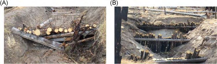
4 Integr Environ Assess Manag 00, 2021—HARING ET AL.
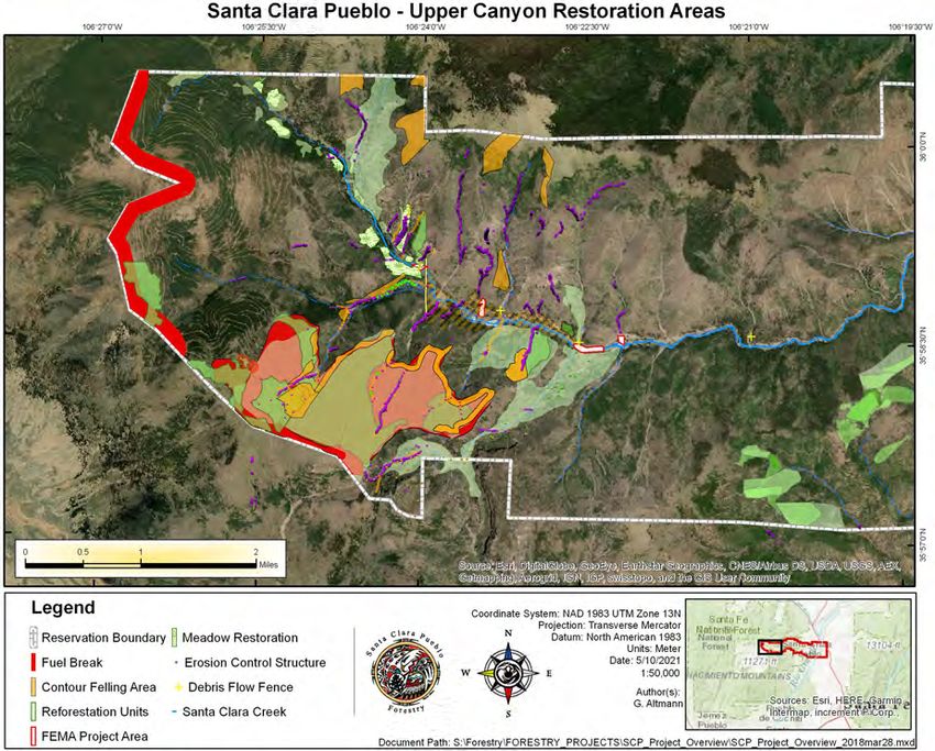
FIGURE 1 Locations within the Santa Clara Canyon where natural infrastructure materials were installed to manage post‐wildfire erosion
natural adaptation, and monitoring for mutual learning available natural materials such as logs, re‐vegetation,
(Cohen‐Shacham et al., 2019; Nesshöver et al., 2017). mulching practices, and native rock to stabilize parts of
the watershed. The Pueblo Forestry Department worked on
Methods for designing and constructing natural
small structure construction in the tributary streams while
material structures
the NRCS implemented mulching and contour felling proj-
TEK from the Santa Clara Pueblo was gathered based on ects, and USACE implemented large grade control struc-
the Tribe's rules and customs, and used as described above tures in the Santa Clara Creek mainstem to dissipate flood
to drive the design and subsequent construction of the energy and collect the vast quantities of sediment coming
natural material structures. All proposed activities were ini- from upstream sources. The erosion control structures are
tially reviewed by the Tribal Historic Preservation Office in various sections of the canyon (Figure 1). A priority for
(THPO). Based on this feedback and utilizing TEK, the restoration also included implementing environmentally
preference for using on‐site natural materials was prioritized, sustainable projects to stabilize the stream system utilizing
which contributed to the low implementation cost because readily available natural materials to encourage native
the construction materials were readily available. This ap- populations of trout to return to the area.
proach was also inherently practical, because most of the For context on what types of practices are applicable to
eroding landscape was steep canyon terrain, so access for treating massive erosion in watersheds, the physical proc-
large equipment to haul materials was logistically infeasible esses that cause the accelerated rates must be identified
and cost prohibitive. The results of this collaboration with and understood. Network‐wide channel instability was
the Tribe yielded a holistic and sustainable approach to identified by localized steepening of slopes, mass wasting of
managing post‐wildfire erosion. The resultant response to streambanks, and widespread channel expansion, in some
the post‐wildfire challenges was the design and construction cases 5–10 times the pre‐fire widths (Figure 2). Many of
of hundreds of erosion control structures that used readily these tributary channels were shallow, easily crossable
Integr Environ Assess Manag 2021:1–9 wileyonlinelibrary.com/journal/ieam Published 2021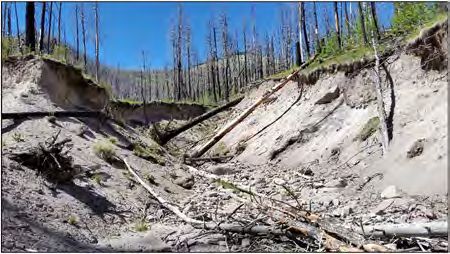
MANAGING POST‐WILDFIRE EROSION VIA ENGINEERING WITH NATURE—Integr Environ Assess Manag 00, 2021                                       5

                                                                         channels were experiencing erosion and mass wasting
                                                                         zones; (2) floodplain depositional zones‐old pond sites,
                                                                         sediment basins, and channel margins on tributaries and
                                                                         mainstem were being infilled; and (3) active tributary and
                                                                         main channel erosion and/or floodplain building and plan‐
                                                                         form changes were being adversely altered (Figure 4).
                                                                           The locations of the nature‐based structures that were
                                                                         constructed in Switchback, Chicoma, and Sasquatch can-
                                                                         yons are shown in Figures 5, 6, and S1–S6. The NRCS rec-
                                                                         ommended contour felling of existing burned tree areas to
                                                                         provide erosion control and promote re‐vegetation. Field
                                                                         crews used in situ materials to construct structures. This
                                                                         reduced the cost of hauling restoration materials to the site
FIGURE 2 Incised tributary to Santa Clara Canyon showing a markedly
expanded channel width post‐wildfire                                      and utilized existing natural materials present in the imme-
                                                                         diate vicinity. The field crews used available plant materials,
streams prior to the wildfire, so changing the watershed                  willows and other transplants, logs, rootwads, cut wood,
runoff characteristics.                                                  branches, and rock. Based on initial, post‐construction re-
                                                                         view of the projects, the structures have provided erosion
Modeling approach to guiding natural infrastructure                      control benefits during recent runoff events as designed,
material design                                                          and all were structurally sound.

   The tributary watersheds experienced large‐scale channel
degradation and deposited massive amounts of debris and                  DISCUSSION
sediment to the main channel and floodplain of Santa Clara
Creek (Figure 3). Channel evolution models (CEM; Cluer &                 Erosion management lessons learned
Thorne, 2013; Hawley et al., 2011; Schumm et al., 1984;                     Based on the approach used to model, design, and
Simon & Hupp, 1986) can be used to predict spatial and                   construct the natural material structures in Switchback,
temporal extents of channel stability within watersheds.                 Chicoma, and Sasquatch canyons, several lessons were
Based on a simplistic approach, the qualitative five‐stage                learned that could inform future applications for reducing
CEM (Schumm et al., 1984) was selected to assess the                     erosion in the wake of large‐scale wildfires.
tributary and mainstem geomorphology. The CEM was used                      The Santa Clara Canyon structures were constructed in a
to identify primary post‐wildfire stream morphologic proc-                design‐and‐build manner. No major survey, design, and
esses and potential future channel stability trends.                     review were carried out prior to construction. Instead, the
                                                                         structures were constructed in real time as the designer and
RESULTS                                                                  crew oriented the readily available local materials to combat
                                                                         channel and hillside erosion. The efficacy of the side‐
Natural material design implementation
                                                                         channel designs will be used along with surveys to inform
   Some of the most intense fires were in the farthest up-                the designs for stabilizing the future Santa Clara Creek
stream reaches of the Santa Clara Canyon, and so field re-                mainstem project.
views were completed to assess watershed stability in these                 Implementation of key construction and engineering
areas. Active watershed, channel, and floodplain processes                techniques is important to achieve resilient designs; the
were identified, including: (1) Santa Clara Creek tributary               results of these techniques can be seen in Figures 5, 6, and
                                                                         S1–S6, and are briefly described here. Structures should be
                                                                         tied into the existing bank. Trenches should be cut into the
                                                                         bank to lock the structures in place. The farther back into the
                                                                         bank, the better the tie‐in or key‐in will work. This is a
                                                                         practice that is imperative to prevent the structures from
                                                                         being flanked or cut around. Structures should also be
                                                                         keyed into the existing channel bed. The slopes of many of
                                                                         the tributaries are very steep, so keying the structures into
                                                                         the bed is as important as the bank key‐in.
                                                                            By using the CEM concepts described earlier, the CEM
                                                                         stage most appropriate to be used as a starting point should
                                                                         be qualitatively determined and preliminary designs se-
                                                                         lected based on the field experience of the project team.
FIGURE 3 Santa Clara Creek illustrating large deposits of post‐wildfire
                                                                         For example, if there are signs of a headcut or nick point
sediment deposition from watershed runoff events                         (channel degradation), bank protection type measures

Integr Environ Assess Manag 2021:1–9                      DOI: 10.1002/ieam.4453                                         Published 2021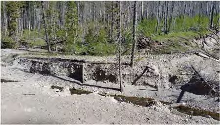
6 Integr Environ Assess Manag 00, 2021—HARING ET AL.
FIGURE 4 Locations where natural infrastructure materials were installed as erosion control features in the Upper Reach of the Santa Clara watershed
should not be considered, but instead, some form of bed Structures built from natural materials should not com-
control should be implemented. pletely block the channel from one floodplain or terrace to
If constructing grade control to stabilize bed degradation, another. Blocking the channel in this way will cause the
determine elevations during structure layout so that the stream to erode around the structure, creating multiple new
downstream structure will retain water on the upstream channels and leading to additional erosion.
structure. This will stabilize the upstream structure and dis- Vegetation should not be planted in channel. If willows
sipate energy at the outlet of the upstream structure or similar species are planted, they should be used on the
(Figure S1). channel margins and banks to provide some protection
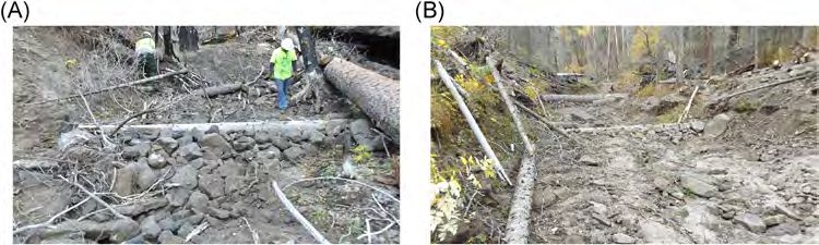
FIGURE 5 Switchback Canyon tree check dam erosion control structures designed to slow water and stabilize the channel
Integr Environ Assess Manag 2021:1–9 wileyonlinelibrary.com/journal/ieam Published 2021MANAGING POST‐WILDFIRE EROSION VIA ENGINEERING WITH NATURE—Integr Environ Assess Manag 00, 2021 7
FIGURE 6 Sasquatch Canyon Erosion Control Structures—rock and lateral tree grade control structures to dissipate energy and stabilize the channel bed and
banks
and stabilization to those areas. Planting in the channel native species that are of cultural or medicinal significance
will potentially clog channel flow and likely flank the to complement the erosion control. Consult with the Tribe
structure. on how TEK can be used to inform these planting decisions.
Livestock exclusion or plant protection is a must when re‐ When effectively included in the design, native vegetation
establishing vegetation as a primary alternative for restora- provides channel margin and floodplain roughness, and
tion measures. The willows that were planted (Figure S2) reduces velocities, leading to energy dissipation of the
exhibit damage from livestock, along with deer and elk that surface flow. Native vegetation can also provide seasonal
forage in the area. Planted vegetation requires at least one variability at differing elevations, age of plantings, and
full growing season to become established and serve the composition of species. For example, it is best to avoid
intended erosion reduction function. Grazing pressure on planting a monotype species to control erosion, because
newly planted vegetation features may require future re- disease, age of stand, and other environmental factors may
planting. Traditional metal fencing can be supplemented decimate the species, leaving the area susceptible to future
with wood post fencing and/or woody debris positioned to erosion.
provide a “jack‐straw” effect to limit browsing. These struc- Existing on‐site materials such as downed trees should be
tures can be constructed to last short durations (1–3 years) used to mulch channel margin areas. Burned logs and brush
to facilitate vegetation establishment and eventual wood can be staked and secured to treat overbank floodplain
decomposition. scour areas where concentrated flows are not advised and
When possible, use some form of ties or wrapping to bind require mitigation. If designed properly, sediment will infill
the structure together to improve the structure's function. areas as a result of the installed structures. Further en-
Jute, fine rope, or even locally sourced yucca fibers can be hancement would include planting willow or other water‐
used to bind the materials together within the structure. The loving species to assist the staked woody materials in dis-
use of staples or metal wire is not recommended because sipating flow energy across the floodplain and catching
they are not biodegradable. sediment to stabilize it. The dispersal of woody debris fol-
If standing trees, logs, and rootwads that are otherwise lowing heavy equipment operations will facilitate biomass
damaged by the wildfire (Figure S3) are available adjacent accumulation, moisture retention, and seed catchment.
to the channel, use the materials to bind the structures to-
Collaboration lessons learned
gether (Figures 5, 6, and S4). Depending on the reach
alignment, concentrate flows in the center of the channel Integrating Tribal feedback throughout the proposal,
and away from the opposite bank to reduce potential design, and construction process was paramount to project
erosion. success. Proposed activities were initially reviewed by the
Structures built from natural materials should be designed THPO, and culturally sensitive areas were field surveyed and
so materials are in compression. For example, cross‐vanes, excluded at times. Project measures needing to use heavy
j‐hooks, bank barbs, or other features should be constructed equipment required pre‐ and post‐design approval by the
with stacked rock in the upstream direction (Figures S5 and Tribal Council and Tribal Cultural Committee. Specific
S6) to most effectively counteract bed shear stress and keep restoration treatments introduced by collaborators were
the structures in place. USACE (1999) and NRCS (1996, adapted to integrate TEK from Tribal Forestry staff, such as
2007) provide additional information on channel re- flood history, wildlife migrations, and historical vegetation
habilitation and grade control structures, which can be occurrence. This led to more effective project location
applied to control erosion in such situations. determination and increased the sense of involvement and
Vegetation management is a key component in stream ownership by tribal personnel. Adaptive management
design. Native vegetation should be incorporated whenever facilitated field TEK innovation for more effective im-
possible to dissipate energy that occurs in natural stream plementation, such as substituting logs when rock avail-
systems—especially in the floodplain. Where possible, plant ability was limited, and when consecutive treatments and
Integr Environ Assess Manag 2021:1–9 DOI: 10.1002/ieam.4453 Published 20218 Integr Environ Assess Manag 00, 2021—HARING ET AL.
monitoring was required. Tribal feedback allowed a more natural materials, keeping in mind that material availability
collective process, increased natural material integration, may change with changing canyon elevation. Livestock
facilitated field innovation, prioritized NbS, all while re- should be removed from any areas that are using vege-
building a sense of resource stewardship and ownership by tation as a restoration measure until the vegetation has
the Tribe. become well established.
And finally, methods should be deployed post‐
Recommendations for further study and next steps
construction to analyze the success of the treatments to
Based upon on‐site qualitative assessments of the NbS inform future NbS designs. Consistent with this recom-
material structures post‐construction, further activities mendation, the USACE will apply FG to monitor long‐term
should include a watershed‐based geomorphic assessment effectiveness of the NbS implemented within the Santa
approach to determining the appropriate actions for Clara Creek watershed.
stabilizing, restoring, and implementing new projects.
Continuing to use and apply simplistic models, such as CONCLUSIONS
the CEM, will assist in identifying geomorphic channel In this paper, we demonstrate how a collaborative effort
processes and expected change. Applying similar EWN between the Santa Clara Pueblo, the USACE, and other
principles within the upper tributary streams will provide federal, state, and local organizations was successfully im-
further erosion control with reductions in sediment plemented to manage Pueblo lands that were threatened by
delivery to the downstream reaches and reduce nick point a large‐scale wildfire in the western United States. The
migration upslope, further enhancing erosion mitigation in project team leveraged collaborative expertise by com-
the watershed. bining diverse organizational resources and identifying
Larger equipment can be used in the canyons where erosion mitigation strategies that were then modified using
space and access are both available to effectively gather the principles of TEK, adaptive management, and EWN to
existing materials to stabilize these reaches. Use of larger complete the design and construction of various erosion
equipment in smaller upslope tributaries may not be pos- control measures. The team implemented a wide range of
sible owing to the lack of access; in these cases, field crews innovative structures made from natural materials that were
are the only option. consistent with EWN principles for erosion control, in-
Designs for all projects, especially for mainstem dams, corporating low‐cost and readily available logs, mulch,
roadway construction, and road crossings, require the vegetation, and local rock to stabilize highly erodible parts
most up‐to‐date data to develop effective NbS designs. of the watershed. The features were monitored after con-
High‐resolution elevation data such as LiDAR (light struction to assess their effectiveness, guiding a series of
detection and ranging) should be collected when more recommendations and next steps for broader im-
detailed watershed analysis is desired. Utilizing Flu- plementation. This is part of a continued effort to emphasize
vialGeomorph (FG), a geomorphic and GIS‐based water- the application of sustainable and resilient project designs
shed assessment capability (Haring et al. 2020), will be using natural materials, as implemented on the Santa Clara
used as the next step in determining how the entire wa- Pueblo. The implementation of the natural material designs
tershed has responded after the structures were installed. is restoring the cultural and medicinal traditions on Pueblo
FluvialGeomorph will also provide insight into how the land and is an example of how EWN can be applied equi-
structures can be repaired, modified, or replaced or new tably in practice.
NbS material structures designed and constructed in other
areas so that watershed erosion can be effectively man- ACKNOWLEDGMENT
aged in the future. The EWN design concepts discussed in this paper were
Next steps in the wildfire watershed recovery effort in- developed in collaboration with the Albuquerque District,
clude continued consultations with the Tribe on how TEK USACE. We thank Ronald Kneebone and Brian Zettle of the
can be used to inform further efforts to design and install USACE Tribal Nations Technical Center of Expertise
additional NbS material channel stabilization measures (TNTCX) for reviewing an earlier version of the manuscript.
while considering the following recommendations. Per- The authors would like to extend a sincere thanks to the
form geomorphic and watershed surveys of new reaches Santa Clara Pueblo and their respective staff, including re-
to determine priority areas for future restoration and sta- views by the Rights Protection Office, Forestry Department
bilization. Future efforts should concentrate on tributaries and Governor’s Office, in support of this research.
to the canyons. The new developing channels should be
traced to the top sediment source points and stabilized CONFLICT OF INTEREST
through application of natural materials as described The authors of this paper declare they have no conflicts of
herein. Much of this work will likely need to be completed interest.
by hiking and manual labor owing to the lack of access for
heavy equipment. Worker safety should be paramount DISCLAIMER
when constructing structures in steep terrain. Innovate and The writing of this paper was funded by the US Army
develop new stabilization measures using readily available Engineer Research and Development Center (ERDC)
Integr Environ Assess Manag 2021:1–9 wileyonlinelibrary.com/journal/ieam Published 2021MANAGING POST‐WILDFIRE EROSION VIA ENGINEERING WITH NATURE—Integr Environ Assess Manag 00, 2021 9
Dredging Operations Technical Support Program, Burton Walters, G. (2019). Core principles for successfully implementing and
Suedel, Program Manager. The views and opinions ex- upscaling Nature‐based solutions. Environmental Science & Policy, 98,
20–29.
pressed in this paper are those of the individual authors and
Dennison, P. E., Brewer, S. C., Arnold, J. D., & Moritz, M. A. (2014).
not those of the US Army Corps of Engineers, US Army
Large wildfire trends in the western United States, 1984–2011. Geo-
Engineer Research and Development Center, or other physical Research Letters, 41, 2928–2933. https://doi.org/10.1002/
sponsor organizations. The peer review for this article was 2014GL059576
managed by the Editorial Board without the involvement of Federal Emergency Management Agency (FEMA). (2016). National disaster
B. Suedel. recovery framework (2nd ed.). https://www.fema.gov/emergency‐managers/
national‐preparedness/frameworks/recovery
Girona‐García, A., Vieira, D. C. S., Silva, J., Fernández, C., Robichaud, P. R., &
DATA AVAILABILITY STATEMENT Keizer, J. J. (2021). Effectiveness of post‐fire soil erosion mitigation
Data available upon request from author Chris Haring treatments: A systematic review and meta‐analysis. Earth‐Science Re-
(Christopher.P.Haring@usace.army.mil). views, 217, 103611 https://doi.org/10.1016/j.earscirev.2021.103611
Haring, C. P., Theiling, C. H., & Dougherty, M. P. (2020). Rapid watershed
assessment tools based on high resolution terrain data (ERDC/CHL
SUPPORTING INFORMATION
CHETN‐VII‐22). Vicksburg, MS: US Army Engineer Research and Devel-
FIGURE S1. Switchback Canyon wattles and lateral log opment Center. https://erdc‐library.erdc.dren.mil/jspui/bitstream/11681/
energy dissipators supplemented with willow plantings in- 36714/3/ERDC‐CHL%20CHETN‐VII‐22.pdf
stalled to control stream erosion. Hawley, R. J., Bledsoe, B. P., Stein, E. D., & Haines, B. E. (2011). Channel
FIGURE S2. Switchback Canyon erosion control evolution model of semiarid stream response to urban‐induced hydro-
modification. Journal of American Water Resources Association 48(4),
structures—willow plantings with lateral log energy dis-
722–744.
sipators. King, J. K., Suedel, B. C., & Bridges, T. S. (2020). Achieving sustainable
FIGURE S3. Santa Clara Canyon—contour felling of ex- outcomes using engineering with nature principles and practices. In-
isting burned trees for erosion control and promotion of tegrated Environmental Assessment and Management, 16(5), 546–548.
re‐vegetation. Mauri, E., & Pons, P. (2019). Handbook of good practices in post‐wildfire
management (2nd ed.). Anifog Project I+D+iCGL2014‐54094‐R. Uni-
FIGURE S4. Chicoma Canyon erosion control
versitat de Girona. 169 pp.
structures—tree check dams with large in situ rock for Natural Resources Conservation Service (NRCS). (1996). Chapter 16: Stream-
channel stabilization. bank and shoreline protection. In Engineering field handbook (pp. 16‐3–
FIGURE S5. Chicoma Canyon erosion control 16‐62). US Department of Agriculture, Natural Resources Conservation
structures—lateral log, woody debris, and in situ rock were Service. https://efotg.sc.egov.usda.gov/references/public/IA/Chapter‐16_
Streambank_and_Shoreline_Protection.pdf.
combined to reduce flow and potential erosion.
Natural Resources Conservation Service (NRCS). (2007). “Grade Stabilization
FIGURE S6. Sasquatch Canyon erosion control Techniques.” Technical supplement 14G, Part 654‐National engineering
structures—rock and lateral tree grade control structures to handbook. https://directives.sc.egov.usda.gov/OpenNonWebContent.aspx?
provide channel bed stability. content=17816.wba
Nelson, D. R., Bledsoe, B. P., Ferreira, S., & Nibbelink, N. P. (2020). Chal-
lenges to realizing the potential of nature‐based solutions. Current
ORCID
Opinion in Environmental Sustainability, 45, 49–55.
Burton C. Suedel https://orcid.org/0000-0002-9220-9594
Nesshöver, C., Assmuth, T., Irvine, K. N., Rusch, G. M., Waylen, K. A., Delbaere,
B., Haase, D., Jones‐Walters, L., Keune, H., Kovacs, E., Krauze, K., Külvik,
REFERENCES M., Rey, F., van Dijk, J., Vistad, O. I., Wilkinson, M. E., & Wittmer, H. (2017).
Altmann, G. (2021). ESRI story map: A tribe's collaborative journey to develop The science, policy and practice of nature‐based solutions: An
forest resiliency. Santa Clara Pueblo: Department of Forestry. https://arcg. interdisciplinary perspective. Science of the Total Environment, 579,
is/0HGPHf 1215–1227.
Bridges, T. S., Bourne, E. M., King, J. K., Kuzminski, H. K., Moynihan, E. B., & Robichaud, P. R., Ashmun, L. E., & Sims, B. D. (2010). Post‐fire treatment
Suedel, B. C. (2018). Engineering With Nature®: An atlas. ERDC/EL SR‐18‐8. effectiveness for hillslope stabilization (Gen. Tech. Rep. RMRS‐GTR‐240).
US Army Engineer Research and Development Center. https://doi.org/10. US Department of Agriculture, Forest Service, Rocky Mountain Research
21079/11681/27929 Station. 62 pp.
Bridges, T. S., Bourne, E. M., Suedel, B. C., Moynihan, E. B., & King, J. K. Robichaud, P. R., Beyers, J. L., & Neary, D. G. (2000). Evaluating the effective-
(2021). Engineering With Nature®: An atlas, Volume 2. ERDC/EL SR‐21‐2. ness of postfire rehabilitation treatments (Gen. Tech. Rep. RMRS‐GTR‐63).
US Army Engineer Research and Development Center. https://doi.org/10. US Department of Agriculture, Forest Service, Rocky Mountain Research
21079/11681/40124 Station. 85 pp.
Cluer, B., & Thorne, C. (2013). A stream evolution model integrating habitat Schumm, S. A., Harvey, M. D., & Watson, C. C. (1984). Incised channels: Mor-
and ecosystem benefits. River Research and Applications 30, 135–154. phology, dynamics and control. Water Resources Publications. 200 pp.
https://doi.org/10.1002/rra.2631 Simon, A. L., & Hupp, C. R. (1986). Channel evolution in modified Tennessee
Coalition for the Upper South Platte. (2014). Wildfire restoration handbook. channels. Proceedings of the Fourth Interagency Sedimentation Confer-
34 pp. http://cusp.ws/wp‐content/uploads/2014/05/Fire‐Restoration‐ ence, March 1986, Las Vegas, NV, 2, 5–71 to 5–82.
HandbookDraft5.7_FINAL.compressed.pdf US Army Corps of Engineers (USACE). (1999). Channel rehabilitation: Proc-
Cohen‐Shacham, E., Andrade, A., Dalton, J., Dudley, N., Jones, M., Kumar, esses, design, and implementation. USACE Engineering and Research
C., Maginnis, S., Maynard, S., Nelson, C. R., Renaud, F. G., Welling, R., & Center.
Integr Environ Assess Manag 2021:1–9 DOI: 10.1002/ieam.4453 Published 2021You can also read