Ward Walk Profile: Bloxwich West - January 2020 Version - FINAL - Walsall Insight
←
→
Page content transcription
If your browser does not render page correctly, please read the page content below
Ward Walk Profile:
Bloxwich West
January 2020
Version - FINAL
Councillors

Name                   Party           Elected on:

Cllr Bradley Allen     Conservatives   5 May 2016

Cllr Matthew Follows Conservatives     7 May 2015

Cllr Louise Harrison   Conservatives   10 June 2004
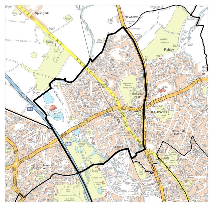
Geography Covers 3.57 sq km (357 ha) Makes up 3.4% of the area of Walsall borough Population density of 38.8 people per hectare (higher than borough average of 27.1) Source: Ordnance Survey; ONS, Mid-2018 Population Estimates
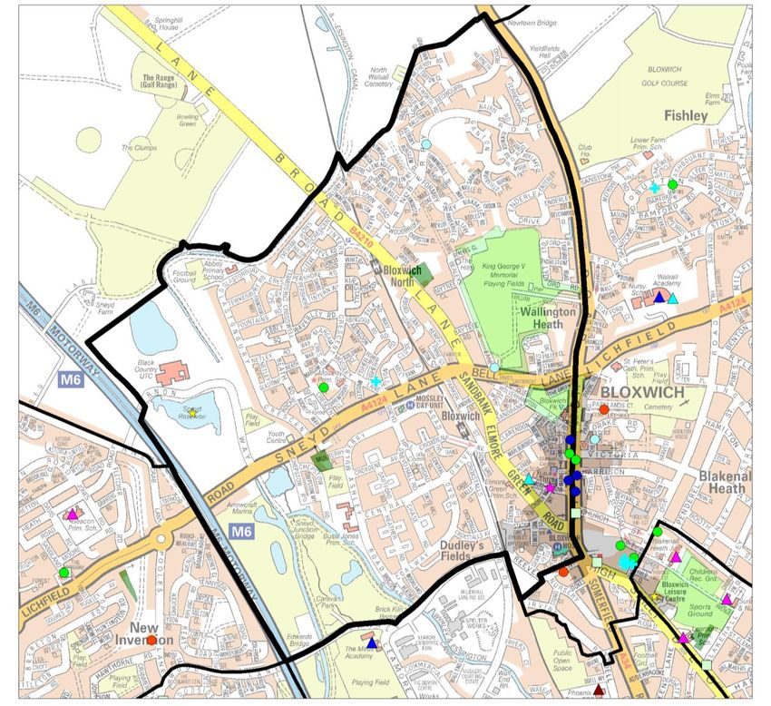
Assets

Source: Ordnance Survey
Population

Source: ONS, Mid-2018 Population Estimates
Ethnicity
Only 5% minority ethnic residents
Asian is the largest minority group at
1.6% (much less than Walsall average
of 15.2%)
Of the Asian minority group, Indian is
the most prolific at 0.5%
Source: ONS, 2011 Census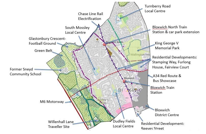
Housing
Composition Tenure
5,032 households (with at least 1
usual resident)
Decrease of 2.3% since 2001
(Proportion of borough total 4.7%)
Average household size: 2.4
residents per h/hold (similar to
Walsall average of 2.5)
6.2% of households ‘overcrowded’*
(Walsall average 6.5%)
3.3% of households without central
heating (Walsall average 2.8%)
High proportion of socially rented
(32.9%) properties compared to
borough (24.1%)
Similar to average (31.9%) mortgage
Source: ONS, 2011 Census owned (30.5%)
Social Segmentation - Groups
The largest groups of households are classified as group M – Family Basics (25%) & group
N – Vintage Value (19%)

                                                                                                  Most effective
                                                                                                  communication
                                                                                                  route

                                                                                                  Least effective
                                                                                                  communication
                                                                                                  routes

  Source: Experian - Mosaic Public Sector Profiler 2019; Ordnance Survey LLPG Address file 2019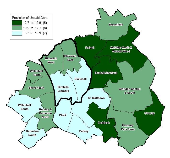
Economic Summary
•   74.0% of working age people in Bloxwich West ward were economically active.
    This equalled the Walsall value of 74.0%, compared with the national value of
    76.8% (2011)*.                                      Unemployment Claimants (aged 16-64), May 2019

•     The largest occupation group in the ward was
      Skilled Trades (15.9%) followed by Elementary
      Occupations (13.5%) (2011)*

•     Of working age ward residents, over a quarter
      (29.6%) had no formal qualifications. Walsall’s
      value was 24.3%, and 15.0% nationally (2011)*.

•     In May 2019, 5.4% of working aged residents
      (aged 16-64) were unemployed and seeking
      work. This equated to 456 people and was
      slightly above the Walsall average of 5.0%.

    Sources: 2011 Census, ONS (% based on residents aged 16-64);
              Alternative Claimant Count, DWP (May 2019)
    * This is the most recent data available at ward level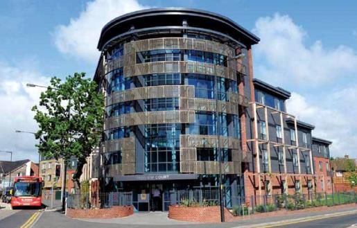
Deprivation

The majority of the ward is
within the 10% most deprived
overall. In contrast, Turnberry
East is within the 10% least
deprived & Turnberry West in
the 20% least deprived.
Note – LSOA (Lower Super Output Area) – part of a
geographical hierarchy with an average population of 1,500

  Source: DCLG, Index of Multiple Deprivation, 2019
Childhood Obesity

 Source: National Child Measurement Programme (NCMP), 2015-18
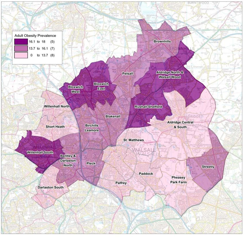
Adult Obesity Prevalence
                                    Prevalence
                Ward
                                       (%)
  Willenhall South                         18.0
  Bloxwich West                            17.7
  Rushall-Shelfield                        17.7
  Aldridge North and Walsall Wood          17.4
  Bloxwich East                            16.9
  Bentley and Darlaston North              16.1
  Birchills Leamore                        16.0
  Pleck                                    15.6
  Brownhills                               15.5
  Pelsall                                  14.8
  Blakenall                                14.7
  Streetly                                 14.5
  Willenhall North                         13.7
  Darlaston South                          12.9
  Pheasey Park Farm                        12.4
  Aldridge Central and South               11.4
  St. Matthews                             10.5
  Palfrey                                   9.8
  Paddock                                   8.0
  Short Heath                                 -
  Walsall Average                         14.4

Bloxwich West has an above average
proportion of adult obesity prevalence
(11.4% compared to 14.4%).
   Source: Quality and Outcomes Framework, 2017/18
Provision of Unpaid Care
Provision of unpaid care in Bloxwich
West is similar to the borough
average (11.7% and 11.4%
respectively).
Ward # %
Bloxwich West 1,412 11.7
Bloxwich East 1,505 11.6
Blakenall 1,437 9.9
Birchills Leamore 1,549 9.7
WALSALL 30,632 11.4
Source: 2011 Census, ONSASC Carers Survey Source: Adult Social Care User Survey (ASCS), 2018-19
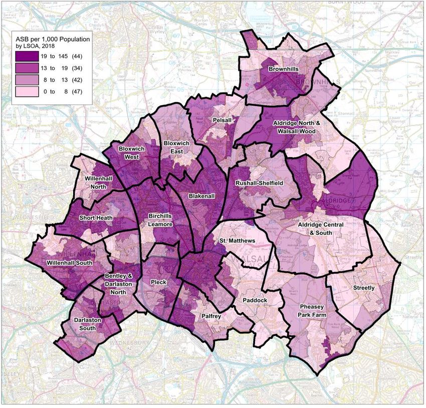
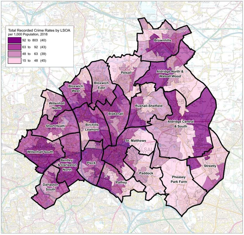
Recorded Crime
                                  Total Recorded
                                                     Serious       A higher number of total recorded crime rates &
                                                    Aquisitive
              Ward
                                       Crime
                                   Rate per 1,000
                                                      Crime           lower rates of serious acquisitive crime rates
                                                  Rate per 1,000
                                    Population
                                                   Population                  than the borough average.
Aldridge Central and South                 77.68           19.03
Aldridge North and Walsall Wood            62.80           16.64
Bentley and Darlaston North               146.17           37.64   Crime by type highlights ‘violence with injury &
Birchills Leamore                         144.27           28.37      violence without injury’ as the most prolific
Blakenall                                 130.43           29.79
Bloxwich East                             112.14           25.06             types in this ward during 2018.
Bloxwich West                             109.25           23.69
Brownhills                                 91.42           16.35   14       12.813.1
Darlaston South                            99.67           21.24   12                                                  9.9               10.1
Paddock                                    58.51           21.35   10                                                                           7.7               7.3
                                                                    8                                5.8                                              6.1                           6.3
Palfrey                                    86.29           19.62    6                                            3.9                                                                                4.7
Pelsall                                    56.72           23.81    4                                      2.5               2.6                                        2.1
                                                                                               1.2
                                                                    2   0              0.2 0.8                                     0.8                      0.6               0.4         0.1 0.9
Pheasey Park Farm                          51.48           19.23    0
Pleck                                     145.97           30.90
Rushall-Shelfield                          77.09           21.53
Short Heath                               271.90           49.10
St Matthew's                               83.41           22.71
Streetly                                   44.59           14.35
Willenhall North                           83.82           21.54
Willenhall South                          163.11           38.93
                                                                                                                                                  *Serious Acquisitive crimes are defined as :
WALSALL                                   107.73           25.40                                                                                  Residential burglary
                                                                                                                                                  Robbery (person)
                                                                                                                                                  Robbery (business)
  Source: West Midlands Police, Jan to Dec 2018                                                                                                   Theft of motor vehicle
                                                                                                                                                  Theft from motor vehicle
Recorded Crime & Anti-social behaviour Source: West Midlands Police, Jan to Dec 2018
Voluntary & Community Organisations Sneyd Community Association - offers a plethora of activities for all ages. Facilities include - swimming pool, large astro turf & a lake for canoeing activities. Clubs include - Sneyd Striders, dog training, indoor bowls, dancing, crafts, sewing & a model railway club. St Thomas Church - hosts the local scout group who also deliver the Duke of Edinburgh scheme, as well as various community activities. They have been working with the Mossley Big Local who have part funded their renovations of a new kitchen, toilets, reception area & disability access (due to be completed in September). A new Revd, Chris Davies joins in September. Mossley Residents - meet bi-monthly to raise issues with local partners. A long standing group who the Council are encouraging to be more proactive. The group links in with Mossley Big Local. Over 60s - a thriving group which brings together some of the older population to do various activities & trips.
Other Information Mossley Youth Club – remains a void Council building. Mossley Big Local expressed an interest in taking over the running of the building but four years later, a decision has not been made by Asset Management on the forward plan of the building. It is listed as an Asset of Community Value. Mattesley Court - a Housing & Care 21 residential building who work with partners & communities to deliver various schemes for their residents & the local community. They are keen to link with activities in the area & regularly host events in the centre & grounds. Mossley Big Local have just renewed their plan which also encompassed changing their Local Trust Organisation from Sneyd CA to One Walsall. King George V Memorial playing fields is a large green space to the North of the ward which offers a play area, a lido in the summer, football, cricket and rugby. July 2017 saw the site invaded with travellers and in November 17 this location was added to the traveller injunction sites. Silver Fitness Scheme is a gym designed with equipment especially for those aged 50 plus. It has specialist equipment to help with rehabilitations and disabilities. It operates through Accord Group at Furlong House.
Regeneration
Bloxwich District Centre – with national retailers / occupiers,
including Asda, Wilkos, Home Bargains, JD Wetherspoon, and multiple
independents.
Circa £1.3m district centre improvements works led by Highways in
progress, including paving works following the demolition of the former
public conveniences.
£1m Bloxwich Townscape Heritage Initiative (2006)
Residential developments, including the Oaks, Furlong House,
Fairview Court, Mattesley Court, Reeves Street, Stamping Way,
Astbury View.
Mossley and Dudley Fields Medical Centre- New building opened in
2015.
King George V Memorial Park improvements
A34 North Red Route and Bloxwich Bus Showcase
Chase Line Rail Electrification complete and new service operational
providing 2 trains per hour at Bloxwich and Bloxwich North stations.
Works included closure of Bloxwich Level Crossing and new
pedestrian footbridge (under construction) and road realignment works
(Leamore Lane/Fryer Rd) led by Network Rail, together with traffic
calming measures (e.g. Dudley Fields).
Blowich North Station Car Park improvements to increase space
provisions, electric charging point and cycle parking.
Source: Regeneration & Development, Walsall CouncilRegeneration – Policy Map Extract Source: Regeneration & Development, Walsall Council
Looking Forward Consideration of the future of the former Sneyd Community School site, including links with Sneyd Community Association and potential outdoor pursuits provider for Sneyd Water Activity Centre. Mossley Youth Club – Asset of Community Value to be subject to either an Community Asset Transfer or best bids proposal. Planned pipeline work to secure a lease holder for the football ground at Glastonbury Crescent. Bloxwich High Street Conservation Area enhancements. Continue to support Bloxwich Business Partnership and sustainability of the District Centre. Source: Regeneration & Development, Walsall Council
Useful Links Walsall Insight: Data and intelligence portal for Walsall, including links to population dashboards, area profiles, needs assessments and additional resources www.walsallintelligence.org.uk 2011 Census: Information related to the release of the latest census results, including analysis and reports for Walsall and links to official ONS websites www.walsall.gov.uk/census Nomis: detailed and up‐to‐date UK labour market and economic statistics from official sources www.nomisweb.co.uk
Acknowledgements
 These profiles have been compiled by analysts and other colleagues
 from across Walsall Insight
 Contact: insight@walsall.gov.uk

 Key Contributors:
 Emma Thomas, Claire Heath, David Hughes & Lee Harley (Public Heath), Liz Connolly
 (Economic Intelligence), Kauser Agha & Caroline Harper (Regeneration &
 Development), John Morris (Localities & Partnerships), Sairah Ahmed (WM Police)

 Reproduced from the Ordnance Survey mapping with the permission of the Controller of Her Majesty’s Stationery Office.
 © Crown copyright. Unauthorised reproduction infringes Crown copyright and may lead to prosecution or civil proceedings.
 © Crown copyright and database rights 2020 Ordnance Survey 100019529.
 NO FURTHER COPIES MAY BE MADE.

 Reproduced by permission of Geographers’ A-Z Map Co. Ltd. Licence No. B3934.
 Crown Copyright 2020. All rights reserved. Licence number 100017302.
 NO FURTHER COPIES MAY BE MADE.
Notes
You can also read