Waymarked Trails from Blair Atholl - £1.50 - cloudfront.net
←
→
Page content transcription
If your browser does not render page correctly, please read the page content below
£1.50

Waymarked Trails
from Blair Atholl
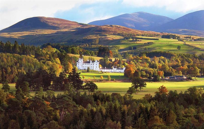
View of Blair Castle from A9 (Paul Booth)

Welcome to Atholl Estates
                     Woodland, rivers and heather-clad hills make up the 145,000 acres that is Atholl
                     Estates. The larger section of the estate is centred on Blair Atholl where Blair Castle,
                     dating to the 1200s, was the historic home of the Earls and Dukes of Atholl. The
                     smaller section of the estate lies between Pitlochry and Dunkeld.

                     The estate has a network of over 30 miles of waymarked trails for you to discover
                     the fascinating history and wildlife of this working landscape. The trails cover a
                     variety of distances and will take you along rivers and burns, through woodlands
                     and onto wild moorland. For the quiet and observant visitor each trail has its own
                     rewards.

                     In the woodlands, sightings of red squirrels and roe deer are common, while you
                     may have the opportunity of seeing two of the most illusive inhabitants, the
                     capercaillie and the shy pine marten. Majestic red deer roam the hills which are
                     also home to mountain hares, and the noisy red grouse. Down at the riverside,
                     tracks indicate the presence of otters. Dippers and wagtails search for insects on
                     which to feed, while salmon battle their way through waterfalls on their upstream
                     journey.

                     You are welcome to explore the estate, but please remember that the estate is a
                     home and workplace for many people. Please respect their privacy and their
                     livelihoods during your visit.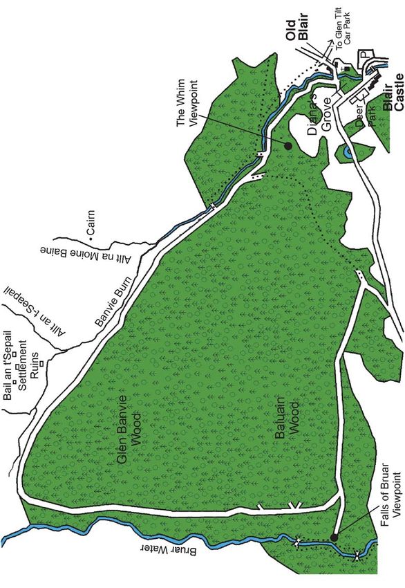
Banvie Burn (Liz Miller)                 Red Squirrel (Ronald W Weir)

The Trails

A starting point is suggested for each walk but, as all the trails are circular, they
can be joined at any point and linked to form longer walks. The map in the centre
pages indicates how all the trails link together. They cover a variety of distances
from a short stroll to a full day’s hike. The distances are written in miles for each
route, with the kilometres equivalent shown in brackets. The routes are denoted
by waymarker posts with colour coded arrows as follows:

       Red Squirrel Walk           1 mile (1.6km)        Red arrows

       Banvie Burn Walk            3 miles (4.8km)       Black arrows

       Farm and Forest Walk        4 miles (6.4km)       Green arrows

       Woodend Walk                4.5 miles (7.2km)     Blue arrows

       Glen Banvie Trail           9 miles (14.5km)      Orange arrows

       Glen Tilt Trail             10 miles (16km)       Yellow arrows

Wherever you decide to go, plan your route carefully, take adequate clothing, food
and drink. Choose a trail that suits the time you have available and your level of
ability. Always wear sturdy walking shoes as even in summer, paths can be muddy
and uneven.

Take care during your walk; many of our riverside paths have steep banks, and
there may be working machinery, especially in farm and forestry areas. Please have
regard for your own safety and ensure that children are supervised at all times.
Whilst every effort is made to ensure public safety, Atholl Estates cannot accept
responsibility for loss of personal effects or injury to visitors.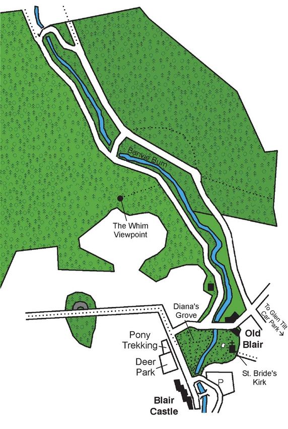
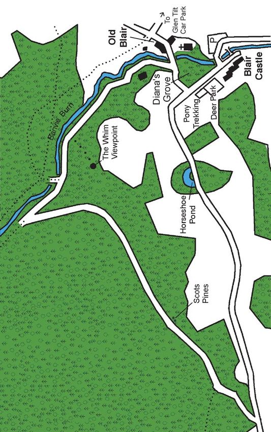
Red Squirrel Walk

                                     Start point: Glen Tilt Car Park
                                     Distance: 1 mile (1.6km)
                                     Follow the red way-markers

                                     This part of Atholl Estates is one of the best places for seeing
                                     red squirrels. There are lots of them about and they are used
                                     to seeing people and dogs. We have no grey squirrels at
                                     Blair Atholl (yet!).

Red squirrel at feeder               To spot red squirrels look up in the trees and also listen for
                                     the scratching sounds of their claws on the bark. If it seems
                                     to be raining bits of pine cone, this is a sure sign that a
                                     squirrel is above, having a feed.

                                     The best time to see squirrels here is in late summer and
                                     autumn when the adults are active, hoarding food for the
                                     winter, and the youngsters are out and about. If you see 2
                                     or 3 squirrels chasing each other around in the trees they
                                     are probably young ones. Baby squirrels are called kittens
                                     and most will not survive their first winter.

                                     As you follow the walk, you can see other signs of squirrel
Eaten Pine cones
                                     activity. Piles of cone cores – the discarded middle of a cone,
                                     like an apple core, are found below branches where squirrels
                                     have been feeding. They pull the outer scales off the cone
                                     to get at the small but nutritious seeds inside. When they
                                     have finished, they just throw it away – watch out for your
                                     head! Their favourite cones are Scots pine, Norway spruce
                                     and larch.

                                     Squirrels also like to eat seeds, nuts (look for split hazelnut
                                     shells), fungi, sap wood from trees and the occasional bird’s
                                     egg.

Red squirrel with winter ear tufts   You can see a lot of squirrel dreys (homes) on this walk,
                                     especially on the first section. Dreys look like birds’ nests,
                                     but are round rather than cup-shaped, with one or two
                                     small entrance holes. Red squirrels are not such skilled
                                     builders as birds, so their dreys are usually built right next
                                     to the trunk of a tree to give some extra support. Squirrels
                                     usually have one main drey for their young and some others
                                     for shelter which may be shared with neighbours.

Squirrel drey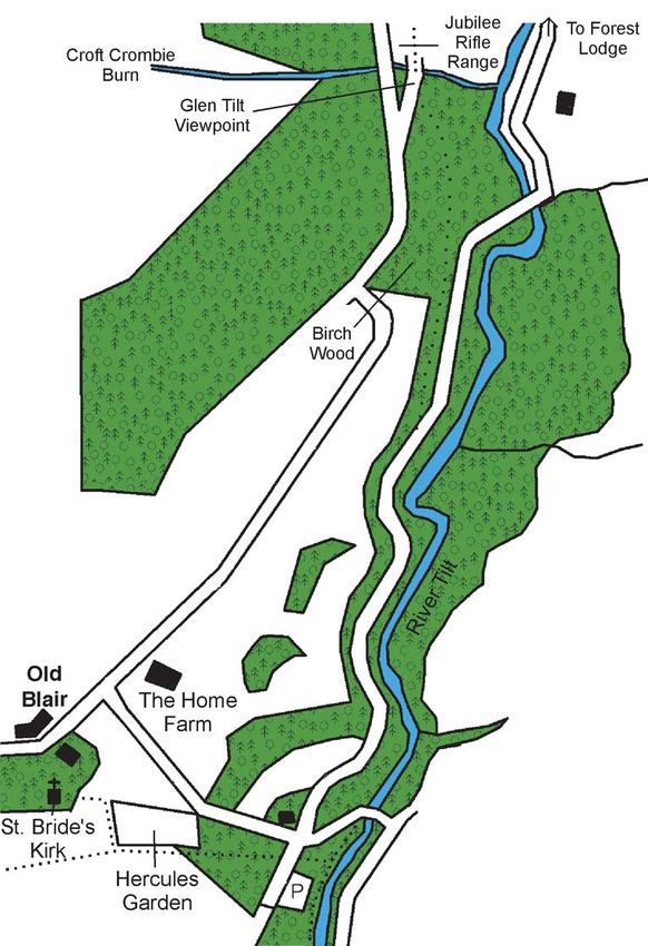
N

Red Squirrel Walk
Route
Banvie Burn Walk

               Start point: Glen Tilt Car Park
               Distance: 3 miles (4.8km) or shortcut 2 miles (3.2km)
               Follow the black way-markers

               From the Glen Tilt Car Park, follow the road up to Old Blair.
               At the crossroads head straight on and then left into the
               woods with the Banvie Burn below you.

               Rhododendron bushes hug the side of the steep gorge.
Rhododendron
               These were planted beside the path in the 18th century,
               and have since spread vigorously. In other parts of this wood
               we have recently felled the rhododendron to allow more
               light and space for other plants and trees to grow.

               At the first bridge you can either take a shortcut across to
               the other side or continue up to the second bridge. After
               heavy rain you can hear the crashing of boulders being
               moved by the rushing water running under the bridge –
               known for this reason as the rumbling bridge.

               At the second bridge you get a good view out to the open
Heather        moor above. This view is gloriously purple with heather in
               July and August. Red deer can often be seen right at the
               edge of the wood here in winter, sheltering from the bad
               weather. In summer the deer herd will be grazing away out
               on the high tops.

               On your return, the detour to the Whim is very worthwhile.
               This folly was built in 1761 to give an eye-catching view up
               from the castle. The view from the Whim back to the castle
               and beyond to Ben Vrackie is also lovely. The parkland and
               designed landscape around Blair Castle stands out very well
               from here. Much of this landscape was created in the 18th
               century by the second Duke of Atholl.
Red Deer

               At the road, turn left back across the burn, and head back
               to the car park.

The Whim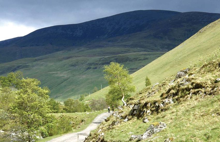
N

Banvie Burn Walk
Route
Farm and Forest Walk
Start point: Glen Tilt Car Park
Distance: 4 miles (6.4km)
Follow the green way-markers
Follow the road from the car park up to Old Blair, and turn
right at the crossroads, up the hill. The fields around you
are part of the Home Farm, which once supplied meat and
crops for Blair Castle. The farm buildings were originally
sited at Blairuachdar, further up the road – far enough away
Greylag goose
from the castle for the farming smells not to offend people.
The farm moved to its current site at Balanloan in Victorian
times. The Home Farm today concentrates on organic beef
and lamb production for Atholl Glens Organic Meat (mail
order business).
As you walk up the hill, the organic fields are a good place
to spot wading birds in the spring or flocks of greylag geese
in the winter. Buzzards are also often seen soaring over the
fields hunting for prey such as rabbits. Listen out for their
mewing call.
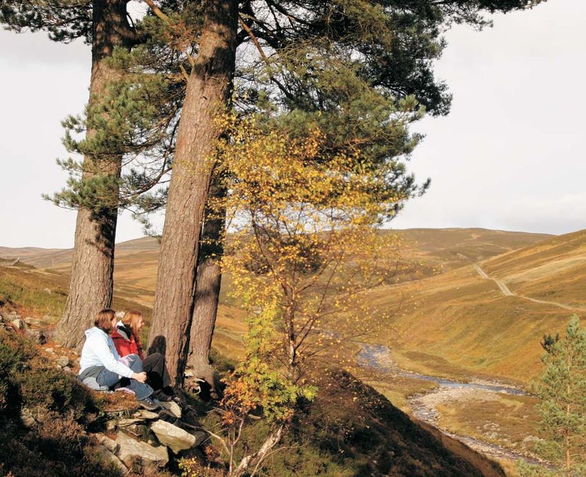
Glen Tilt viewpoint Before you head downhill on the grassy track, you may
want to continue ahead for 100m to enjoy the spectacular
view up Glen Tilt from the top of the rifle range.
Follow the track downhill and on into a birch wood. Birch
trees provide a home for a wide variety of birds and insects,
and once provided useful wood for the many people living
up the glen, for making spoons and bowls. Birch branches
were also used, for roofing houses and stuffing mattresses.
As you head back down Glen Tilt, you can see the River Tilt
flowing down a steep gorge. Rare flowers, such as small
cow-wheat and herb Paris, grow on the sides of the gorge,
Buzzard
where sheep and deer have not been able to eat them. It
is now a Site of Special Scientific Interest, one of a national
network of nature conservation sites.
Small Cow Wheat (Scottish Wildlife Trust)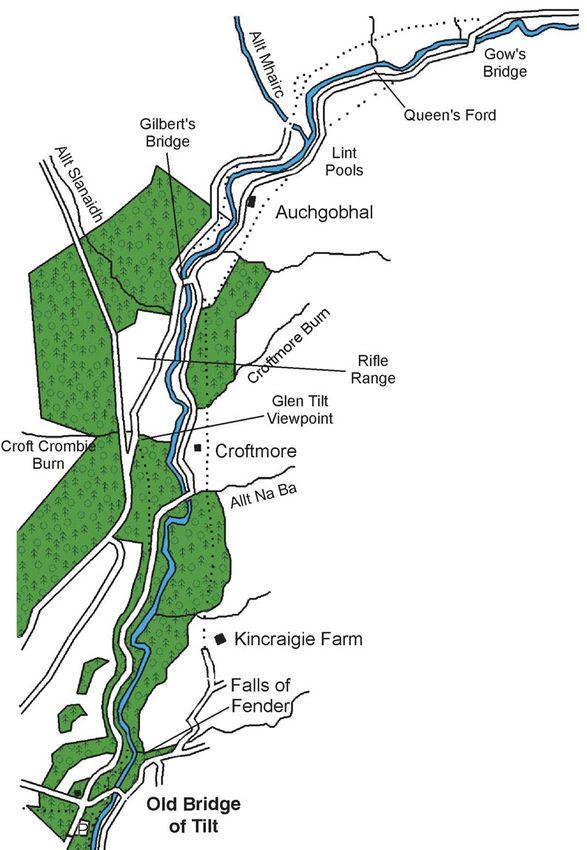
N

Farm and Forest Walk
Route
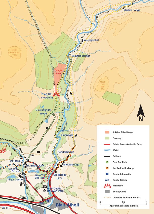
Atholl Estates Waymarked Trails
Red Squirrel Walk      1 mile (1.6km)                        Red arrows

Banvie Burn Walk       3 miles (4.8km) (Short-cut 2 miles)   Black arrows

Farm and Forest Walk   4 miles (6.4km)                       Green arrows

Woodend Walk           4.5 miles (7.2km)                     Blue arrows

Glen Banvie Trail      9 miles (14.5km)                      Orange arrows

Glen Tilt Trail        10 miles (16km) (Short-cut 2 miles)   Yellow arrows
Woodend Walk

                        Start point: Glen Tilt Car Park
                        Distance: 4.5 miles (7.2km)
                        Follow the blue way-markers

                        From the Glen Tilt Car Park, follow the road up the hill to
                        Old Blair. At the crossroads turn left and follow the road
                        round to the right, past Diana’s Grove, a collection of exotic
                        conifers with some of the tallest trees in Britain.
The Whim
                        At the pony trekking centre turn right along the track. The
                        highland ponies are very strong and sure-footed – very useful
                        for both trekking and deer stalking (the ponies carry the
                        deer carcass off the hill). They have a thick coat allowing
                        them to live outside all year round.

                        Walking along the West Drive you get a lovely view of the
                        parkland around Blair Castle. We have recently planted a
                        lot of new parkland trees to replace the old and dying ones.
                        Not only do these trees look attractive, they also provide
                        important shelter for the farm animals in the fields.

Highland pony           Entering the woodland, the route takes you uphill. Gaps in
                        the trees reveal striking glimpses of the valley below and
                        Ben Vrackie straight ahead.

                        Much of the woodland here is larch – a deciduous conifer
                        losing its needles in winter. The path is carpeted with soft,
                        golden needles in the autumn. The larch tree has an indelible
                        link with the Dukes of Atholl and Atholl Estates. In the
                        eighteenth and early nineteenth century, the second and
                        fourth dukes were the first to plant larch commercially for
                        timber, rather than just for decoration. The hybrid larch ( a
                        hybrid between European and Japanese larch) was also
                        developed on Atholl Estates, near Dunkeld, and is the main
View from The Whim
                        larch species used in forestry today. The timber from larch
                        is strong and extremely water resistant.

                        After reaching the top of the hill, you follow the tumbling
                        Banvie Burn back to the road, and so to the car park.

Larch trees in winter
N Woodend Walk Route
Glen Banvie Trail

                 Start point: Glen Tilt Car Park
                 Distance: 9 miles
                 Follow the orange way-markers

                 From the car park follow the road uphill to Old Blair and
                 turn left at the crossroads. Follow the road sharply right,
                 over the Banvie Burn, and then take the track uphill on your
                 right into the Banvie Woods. This woodland is a good place
Black grouse
                 to spot a red squirrel; they enjoy the mixture of nuts and
                 seeds which the different trees provide.

                 As you head out of the woods to the open moor, look out
                 for black grouse. These large game birds live on the woodland
                 edge. The males are a spectacular sight with black bodies,
                 white tails and red eyebrows. Black grouse are declining
                 severely in Britain, but we have a good population here in
                 Perthshire, which are doing well. Further out on the moor
                 you may see, or more likely hear, their cousin the red grouse,
                 as they tell you to ‘go back, go back, go back’.

                 Further up the track on your right is a grassy area with stone
Scots pine       ruins – the remains of Bail an t’Sepail (Chapel Town), which
                 was settled until the 1850s. Now it is a good spot to see
                 red deer enjoying the sweet grazing.

                 Entering the wood at the top of the hill you can see that
                 lots of the Scots pine trees have been rubbed and de-barked.
                 This is done by red deer; they like the resinous smell of some
                 of the trees and rub them vigorously. They also eat the
                 young shoots on the trees – compare them to the trees on
                 the other side of the fence, which are protected from the
                 deer.

                 At the bottom of the hill, a detour to the Falls of Bruar
Red deer
                 viewpoint will reward you with stunning views over this
                 series of waterfalls.

                 As you return towards Blair Castle, views of the River Garry
                 and Ben Vrackie, above Pitlochry, fill the scene.

Falls of Bruar
N Glen Banvie Trail
RouteGlen Tilt Trail
Start point: Glen Tilt Car Park
Distance: 10 miles (16km) or shortcut 6 miles (9.6km)
Follow the yellow way-markers
The River Tilt follows a geological fault through the hills for
much of its length. This has created a steep gorge in places,
but also makes an excellent route for travelling through the
hills with little climbing. Glen Tilt was once a busy route
Glen Tilt
linking Braemar and places north of the Cairngorms to
markets further south.
This walk enjoys the variety of the glen, starting through
the woods and then heading out to the open hillsides. Keep
your eyes peeled for buzzards, eagles, wheatears and skylarks.
After a steep climb up to the top of the rifle range you reach
the Glen Tilt viewpoint, giving a fantastic view of the glen
ahead. Consult the rifle range timetable to check for shooting
– a red flag shows when shooting is taking place. (This
timetable is also available in advance at the Glen Tilt Car
Park or on the ranger service website.)
Allt Mhairc bridge
Back at the bottom of the hill you have the option to shortcut
across Gilbert’s Bridge for the 6 mile walk.
The longer trail continues through the gate. We are aiming
to regenerate the birch wood on this side of the river, inside
the electric fence, getting young trees to seed and grow
amongst the old ones. Deer and sheep love to eat young
trees, so we need to keep them out until new trees are
established.
After crossing the small bridge over the Allt Mhairc, take
the small detour to the viewpoint and ruins above. Hundreds
Common blue (Butterfly Conservation) of people used to live in the glen in settlements like this,
farming cattle and sheep and growing potatoes, turnips
and barley.
At Gow’s Bridge, your walk turns to head back down the
glen.
On your return, enjoy the variety of flowers such as common
rock-rose, milkwort and various orchids, which thrive on the
lime-rich soils in the glen. On a sunny summer day lots of
different butterflies feed on these flowers. In August, clouds
of orange and brown Scotch Argus can be particularly
striking.
Scotch argus (Butterfly Conservation)Glen Tilt Trail
Route
N
Rock rose (Scottish Natural Heritage)
OrchidWalkers in Glen Tilt
Visitors’ Code
For a safe and enjoyable visit please remember that Atholl Estates is a place of
work. Be considerate towards other users of the countryside and follow the Scottish
Outdoor Access Code:
Take responsibility for your own actions.
● Enjoy the outdoors, but take care and watch out for natural hazards
Care for our environment
● Please take your litter home. Litter and food scraps attract scavengers
● Guard against fire at all times
● Please don’t feed our farm animals or animals in the wild
● Please leave wild flowers and plants for everyone to enjoy
● Please keep your dog under close control and do not allow it to harass wild
animals
Help us to work safely and effectively
● Follow advice given on signs about forestry and farming operations
● Do not block gateways or access tracks – park in designated areas
● Keep dogs on a lead or under close control in fields or hill sheep areas to avoid
distressing farm stockPeacock butterfly (Jack Murphy) Blackface sheep Atholl Estates Information Centre Visit the information centre for information on local wildlife, estate management, and what to see and do in the area. The centre is in Blair Atholl, opposite the Blair Castle Caravan Park and next to the fish and chip shop. It is open daily from Easter to October, with ranger staff available between 3.30 and 4.45pm. Hillphone For information on hillwalking and access during the stag stalking season – 12th August to 20th October – please phone our Hillphone on 01796 481740 or check the notice in the Glen Tilt Car Park. The information is updated by 8.00am every day. Ranger Events Atholl Estates Ranger Service runs a wide variety of countryside events for adults and children between Easter and October. Check the events page of our website or pick up a local countryside events leaflet. Atholl Estates You can find out more about the estate’s activities including Blair Castle, pony trekking, farm and land rover wildlife tours, events and much more by visiting our website at www.atholl-estates.co.uk or by picking up one of our many brochures. The estate also has a range of accommodation options including self-catering lodges and Blair Castle Caravan Park. More information and booking details can be found on the website. The full range of Atholl Estates’ brochures is available at the Atholl Estates Information Centre (see above), at the Blair Castle Caravan Park reception or at Pitlochry Tourist Information Centre. Atholl Estates Ranger Service is part-funded by Scottish Natural Heritage (SNH).
Inverness
                                                                                                       Aberdeen

                                                                                                   Dundee

                                                                                               Perth

                                                                                  Glasgow        Edinburgh

Getting Here
By Train

There is a train station in Blair Atholl, with a regular connecting service from all the
major Scottish cities. A daily express service to and from London’s Kings Cross stops
at Pitlochry Station, and the Caledonian Sleeper to and from London Euston stops
at Blair Atholl.

By Car

Blair Atholl is located just off the main A9 road in Highland Perthshire, approximately
35 miles (56km) north of Perth. The village is approximately 90 minutes drive from
Glasgow, Edinburgh, Inverness and Aberdeen.

Contact us
We warmly welcome enquiries and booking for ranger service events by telephone,
fax, email, or in person.

Tel: 01796 481646 (Easter until October only) / 01796 481355
Fax: 01796 481211
Mail: Atholl Estates Office, Blair Atholl, Pitlochry, Perthshire PH18 5TH
Email: enquiries@atholl-estates.co.uk
Web: www.athollestatesrangerservice.co.uk
You can also read