Weather Research and Forecasting (WRF) Model IMPACTS
←
→
Page content transcription
If your browser does not render page correctly, please read the page content below
Data User Guide

Weather Research and Forecasting (WRF)
Model IMPACTS
Introduction
The Weather Research and Forecasting (WRF) Model IMPACTS dataset includes model data
simulated by the Weather Research and Forecasting (WRF) model for the Investigation of
Microphysics and Precipitation for Atlantic Coast-Threatening Snowstorms (IMPACTS)
field campaign. IMPACTS was a three-year sequence of winter season deployments
conducted to study snowstorms over the U.S Atlantic Coast (2020-2022). The campaign
aimed to (1) Provide observations critical to understanding the mechanisms of snowband
formation, organization, and evolution; (2) Examine how the microphysical characteristics
and likely growth mechanisms of snow particles vary across snowbands; and (3) Improve
snowfall remote sensing interpretation and modeling to significantly advance prediction
capabilities. The WRF model provided simulations of the precipitation events that were
observed during the campaign using initial and boundary conditions from the Global
Forecast System (GFS) model and the North American Mesoscale Forecast System (NAM).
The WRF IMPACTS dataset files are available from January 12 through March 7, 2020 in
netCDF-3 format.

Citation
Colle, David and Stacy Brodzik. 2020. Weather Research and Forecasting (WRF) Model
IMPACTS [indicate subset used]. Dataset available online from the NASA Global Hydrology
Resource Center DAAC, Huntsville, Alabama, U.S.A. doi:
http://dx.doi.org/10.5067/IMPACTS/WRF/DATA101

Keywords:
NASA, GHRC, IMPACTS, WRF, numerical weather prediction, parameterizations, precipitation

Campaign
The Investigation of Microphysics and Precipitation for Atlantic Coast-Threatening
Snowstorms (IMPACTS), funded by NASA’s Earth Venture program, is the first
comprehensive study of East Coast snowstorms in 30 years. IMPACTS will fly a
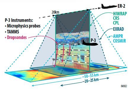
complementary suite of remote sensing and in-situ instruments for three 6-week
deployments (2020-2022) on NASA’s ER-2 high-altitude aircraft and P-3 cloud-sampling
aircraft. The first deployment began on January 17, 2020 and ended on March 1, 2020.
IMPACTS samples U.S. East Coast winter storms using advanced radar, LiDAR, and
microwave radiometer remote sensing instruments on the ER-2 and state-of-the-art
microphysics probes and dropsonde capabilities on the P-3, augmented by ground-based
radar and rawinsonde data, multiple NASA and NOAA satellites (including GPM, GOES-16,
and other polar orbiting satellite systems), and computer simulations. IMPACTS addressed
three specific objectives: (1) Provide observations critical to understanding the
mechanisms of snowband formation, organization, and evolution; (2) Examine how the
microphysical characteristics and likely growth mechanisms of snow particles vary across
snowbands; and (3) Improve snowfall remote sensing interpretation and modeling to
significantly advance prediction capabilities. More information is available from NASA’s
Earth Science Project Office’s IMPACTS field campaign webpage.
Figure 1: IMPACTS airborne instrument suite
(Image source: NASA IMPACTS ESPO)
Product Description
The Weather Research and Forecasting (WRF) model is an open-source numerical weather
prediction (NWP) model system designed for research and operational applications. Its
development involved various organizations including the National Center for Atmospheric
Research (NCAR), the National Oceanic and Atmospheric Administration (NOAA), the U.S.
Air Force, the U.S. Naval Research Laboratory, the University of Oklahoma, and the Federal
Aviation Administration (FAA). A NWP model is essentially a computer program that runs
mathematical simulations of the Earth’s atmosphere, largely based on the governing
equations of motion, to determine a future state of the atmosphere given a set of initialconditions. These models also include parameterizations which are components of a
numerical model that cannot be explicitly calculated because they are too small scale or
complex. Their values are therefore determined using a simplified approach. WRF can use
actual atmospheric data as initial conditions or use idealized conditions. From there, the
model simulates the various atmospheric processes to determine the resulting atmospheric
conditions at some time period from the initial state. Because WRF can be used for research
or operational purposes, it can take on a wide variety of configurations for use by different
user groups. More information about the WRF model is available on the NCAR WRF Model
webpage.
Investigators
David Colle
Stony Brook University
Stony Brook, NY
Stacy Brodzik
University of Washington
Seattle, WA
Data Characteristics
The Weather Research and Forecasting (WRF) Model IMPACTS dataset contains WRF
forecast data simulated for the IMPACTS campaign. The initial and boundary conditions for
WRF were from the Global Forecast System (GFS) model from the National Weather
Service and the North American Mesoscale Forecast System (NAM). Each file is valid for a
particular hour of the simulation. The WRF is run with 36-km (d01), 12-km (d02), and 4-
km (d03) domains. The model is saved every 3 hours for the 36- and 12-km domains (d01
and d02), and saved every hour for the 4-km domain (d03). Ingests occur every 12 hours at
0000 UTC and 1200 UTC. These data are available at a Level 4 processing level. More
information about the NASA data processing levels is available on the EOSDIS Data
Processing Levels webpage. The characteristics of this dataset are listed in Table 1 below.
Table 1: Data Characteristics
Characteristic Description
Platform Weather Research and Forecasting model (WRF)
Spatial Coverage N: 53.589, S: 22.971, E: -53.798, W: -114.202 (United States)
Domain 1 (d01): 36-km
Spatial Resolution Domain 2 (d02): 12-km
Domain 3 (d03): 4-km
Temporal Coverage January 12, 2020 - March 7, 2020
Temporal Resolution Hourly
Atmosphere and surface variables (e.g. temperature, latent
Parameter
heating, soil moisture)
Version 1Processing Level 4
File Naming Convention
The Weather Research and Forecasting (WRF) Model IMPACTS dataset files are separated
by model. The files are stored in netCDF-3 format and named using the following
convention:
Data files: IMPACTS_wrfout_[d01|d02|d03]_YYYYMMDD__[GFS|NAM].nc
Table 2: File naming convention variables
Variable Description
WRF model domain number
d01: 36-km domain
[d01|d02|d03]
d02: 12-km domain
d03: 4-km domain
YYYY Four-digit year
MM Two-digit month
DD Two-digit day
WRF ingest hour
** 00: 0000 UTC
12: 1200 UTC
## WRF Forecast hour (ranging from 00- 48)
Forecast Model
[GFS|NAM] GFS: Global Forecast System
NAM: North American Mesoscale Forecast System
.nc netCDF-3 format
Data Format and Parameters
The Weather Research and Forecasting (WRF) Model IMPACTS dataset files are separated
by forecast model: GFS and NAM. Each file contains data valid for a particular hour of the
simulation. This dataset contains all the variables from the WRF model on sigma levels. The
data fields contained in both the WRF GFS and WRF NAM netCDF-3 files are listed in Table
3 below.
Table 3: WRF GFS/NAM netCDF-3 data fields
Variable Description Units
Times Times -
LU_INDEX Land use category -
ZNU Eta values on half (mass) levels -
ZNW Eta values on full (w) levels -
ZS Depths of centers of soil layers m
DZS Thicknesses of soil layers m
VAR_SSO Variance of subgrid-scale orography m2U x-wind component m s-1
V y-wind component m s-1
W z-wind component m s-1
PH Perturbation geopotential m2 s-2
PHB Base-state geopotential m2 s-2
T Perturbation potential temperature (theta-t0) K
HFX_FORCE SCM ideal surface sensible heat flux W m-2
LH_FORCE SCM ideal surface latent heat flux W m-2
TSK_FORCE SCM ideal surface skin temperature W m-2
HFX_FORCE_TEND SCM ideal surface sensible heat flux tendency W m-2 s-1
LH_FORCE_TEND SCM ideal surface latent heat flux tendency W m-2 s-1
TSK_FORCE_TEND SCM ideal surface skin temperature tendency W m-2 s-1
MU Perturbation dry air mass in column Pa
MUB Base state dry air mass in column Pa
NEST_POS Nest position -
P Perturbation pressure Pa
PB BASE STATE PRESSURE Pa
FNM Upper weight for vertical stretching -
FNP Lower weight for vertical stretching -
RDNW Inverse d(eta) values between full (w) levels -
Inverse d(eta) values between half (mass)
RDN -
levels
DNW d(eta) values between full (w) levels -
DN d(eta) values between half (mass) levels -
CFN Extrapolation constant -
CFN1 Extrapolation constant -
THIS_IS_AN_IDEAL_R
T/F flag: this is an ARW ideal simulation -
UN
P_HYD Hydrostatic pressure Pa
Q2 QV at 2 M kg kg-1
T2 TEMP at 2 M K
TH2 POT TEMP at 2 M K
PSFC SFC PRESSURE Pa
U10 U at 10 M m s-1
V10 V at 10 M m s-1
RDX Inverse x grid length -
RDY Inverse y grid length -
RESM Time weight constant for small steps -
ZETATOP Zeta at model top -
CF1 2nd order extrapolation constant -
CF2 2nd order extrapolation constant -
CF3 2nd order extrapolation constant -
ITIMESTEP Timestep -
QVAPOR Water vapor mixing ratio kg kg-1QCLOUD Cloud water mixing ratio kg kg-1
QRAIN Rain water mixing ratio kg kg-1
QICE Ice mixing ratio kg kg-1
QSNOW Snow mixing ratio kg kg-1
QGRAUP Graupel mixing ratio kg kg-1
QNICE Ice number concentration kg-1
QNRAIN Rain number concentration kg-1
SHDMAX Annual max veg fraction -
SHDMIN Annual min veg fraction -
SNOALB Annual max snow albedo in fraction -
TSLB Soil temperature K
SMOIS Soil moisture m m-3
3
SH2O Soil liquid water m3 m-3
SMCREL Relative soil moisture -
SEAICE Sea ice flag -
XICEM Sea ice flag (previous step) -
SFROFF Surface runoff mm
UDROFF Underground runoff mm
IVGTYP Dominant vegetation category -
ISLTYP Dominant soil category -
VEGFRA Vegetation fraction -
GRDFLX Ground heat flux W m-2
ACGRDFLX Accumulated ground heat flux J m-2
ACSNOM Accumulated melted snow kg m-2
SNOW Snow water equivalent kg m-2
SNOWH Physical snow depth m
CANWAT Canopy water kg m-2
SSTSK Skin sea surface temperature K
COSZEN COS of solar zenith angle -
LAI Leaf area index m /m-2
-2
QKE Twice TKE from MYNN m2 s-2
VAR Orographic variance -
TKE_PBL TKE from PBL m s-2
2
EL_PBL Length scale from PBL m
O3RAD Radiation 3D ozone ppmv
MAPFAC_M Map scale factor on mass grid -
MAPFAC_U Map scale factor on u-grid -
MAPFAC_V Map scale factor on v-grid -
MAPFAC_MX Map scale factor on mass grid, x direction -
MAPFAC_MY Map scale factor on mass grid, y direction -
MAPFAC_UX Map scale factor on u-grid, x direction -
MAPFAC_UY Map scale factor on u-grid, y direction -
MAPFAC_VX Map scale factor on v-grid, x direction -
MF_VX_INV Inverse map scale factor on v-grid, x direction -MAPFAC_VY Map scale factor on v-grid, y direction -
F Coriolis sine latitude term s-1
E Coriolis cosine latitude term s-1
SINALPHA Local sine of map rotation -
COSALPHA Local cosine of map rotation -
HGT Terrain Height m
TSK Surface skin temperature K
P_TOP Pressure top of the model Pa
T00 Base state temperature K
P00 Base state pressure Pa
TLP Base state lapse rate K m-1
TISO Temp at which the base T turns const K
Base state lapse rate (dt/d(ln(p)) in
TLP_STRAT K
stratosphere
P_STRAT Base state pressure at bottom of stratosphere Pa
MAX_MSTFX Max map factor in domain -
MAX_MSTFY Max map factor in domain -
RAINC Accumulated total cumulus precipitation mm
RAINSH Accumulated shallow cumulus precipitation mm
PRATEC Precip rate from cumulus scheme mm s-1
PRATESH Precip rate from shallow cumulus scheme mm s-1
RAINCV Time-step cumulus precipitation mm
RAINSHV Time-step shallow cumulus precipitation mm
RAINNCV Time-step nonconvective precipitation mm
RAINBL PBL time-step total precipitation mm
SNOWNC Accumulated total grid scale snow and ice mm
GRAUPELNC Accumulated total grid scale graupel mm
HAILNC Accumulated total grid scale hail mm
SNOWNCV Time-step nonconvective snow and ice mm
GRAUPELNCV Time-step nonconvective graupel mm
HAILNCV Time-step nonconvective hail mm
REFL_10CM Radar reflectivity (lamda = 10 cm) dBZ
CLDFRA Cloud fraction -
SWDOWN Downward short wave flux at ground surface W m-2
GLW Downward long wave flux at ground surface W m-2
Normal short wave flux at ground surface
SWNORM W m-2
(slope-dependent)
ACSWUPT Accumulated upwelling shortwave flux at top J m-2
Accumulated upwelling clear sky shortwave
ACSWUPTC J m-2
flux at top
Accumulated downwelling shortwave flux at
ACSWDNT J m-2
top
Accumulated downwelling clear sky shortwave
ACSWDNTC J m-2
flux at topAccumulated upwelling shortwave flux at
ACSWUPB J m-2
bottom
Accumulated upwelling clear sky shortwave
ACSWUPBC J m-2
flux at bottom
Accumulated downwelling shortwave flux at
ACSWDNB J m-2
bottom
Accumulated downwelling clear sky shortwave
ACSWDNBC J m-2
flux at bottom
SWUPT Instantaneous upwelling shortwave flux at top W m-2
Instantaneous upwelling clear sky shortwave
SWUPTC W m-2
flux at top
Instantaneous downwelling shortwave flux at
SWDNT W m-2
top
Instantaneous downwelling clear sky
SWDNTC W m-2
shortwave flux at top
Instantaneous upwelling shortwave flux at
SWUPB W m-2
bottom
Instantaneous upwelling clear sky shortwave
SWUPBC W m-2
flux at bottom
Instantaneous downwelling shortwave flux at
SWDNB W m-2
bottom
Instantaneous downwelling clear sky
SWDNBC W m-2
shortwave flux at bottom
OLR TOA outgoing long wave W m-2
ALBEDO Albedo -
CLAT Computational grid latitude, south is negative degree_north
ALBBCK Background albedo -
EMISS Surface emissivity -
NOAHRES Residual of the noah surface energy budget W m-2
TMN Soil temperature at lower boundary K
XLAND Land mask (1 for land, 2 for water) -
UST U* in similarity theory m s-1
PBLH PBL Height m
HFX Upward heat flux at the surface W m-2
QFX Upward moisture flux at the surface kg m-2 s-1
LH Latent heat flux at the surface W m-2
ACHFX Accumulated upward heat flux at the surface J m-2
Accumulated upward latent heat flux at the
ACLHF J m-2
surface
Flag indicating snow coverage (1 for snow
SNOWC -
cover)
SR Fraction of frozen precipitation -
SAVE_TOPO_FROM_R 1=original topo from real/0=topo modified by
-
EAL WRFREFD_MAX Max derived radar refl dbZ
ISEEDARR_SPPT Array to hold seed for restart, SPPT -
ISEEDARR_SKEBS Array to hold seed for restart, SKEBS -
ISEEDARR_RAND_PER
Array to hold seed for restart, RAND_PERT -
TURB
ISSEEDARRAY_SPP_C
Array to hold seed for restart, RAND_PERT2 -
ONV
ISEEDARRAY_SPP_PB
Array to hold seed for restart, RAND_PERT3 -
L
ISEEDARRAY_SPP_LS
Array to hold seed for restart, RAND_PERT3 -
M
BF Full levels, bf=0 => isobaric; bf=znw => sigma -
C1H Half levels, c1h = d bf / d eta, using znw -
C2H Half levels, c2h = (1-c1h)*(p0-pt) Pa
BH Half levels, bh=0 => isobaric; bh=znu => sigma -
C1F Full levels, c1f = d bf / d eta, using znu -
C2F Full levels, c2f = (1-c1f)*(p0-pt) Pa
C3H Half levels, c3h = bh -
C4H Half levels, c4h = (eta-bh)*(p0-pt)+pt, using znu Pa
C3F Full levels, c3f = bf -
C4F Full levels, c4f = (eta-bf)*(p0-pt)+pt, using znw Pa
PCB Base state dry air mass in column Pa
PC Perturbation dry air mass in column Pa
LANDMASK Land mask (1 for land, 0 for water) -
LAKEMASK Lake mask (1 for lake, 0 for non-lake) -
SST Sea surface temperature K
SST_INPUT Sea surface temperature from wrflowinput file K
Algorithm
Numerical weather models utilize governing equations that describe the physical behavior
of the atmosphere, numerical methods that allow computers to solve these equations, and
parameterizations which are used to account for processes that cannot be explicitly
calculated by the model. The Spectral-Bin Microphysics (SBM) parameterization scheme is
often used for WRF simulations. The SBM scheme characterizes the microphysical
precipitation processes that are simulated within the model. More details about WRF-SBM
are available on the NASA GSFC WRF-SBM webpage.
Quality Assessment
Because WRF is a very user-driven model system, the model regularly receives code
contributions and improvements. These modifications are required to undergo thorough
testing before being submitted for the model. More information about WRF contribution
and testing requirements is available on the NCAR WRF User Support & Contributor
Information webpage.Software
This dataset is in netCDF-3 format and does not require any specific software to read.
However, the data are easily readable and viewed in Panoply.
Known Issues or Missing Data
There are no known issues with these data or any known gaps in the dataset.
References
NASA ESPO. (2020). IMPACTS.
https://espo.nasa.gov/impacts/content/IMPACTS
NASA GSFC. (2020). WRF-SBM.
https://cloud.gsfc.nasa.gov/index.php?section=35
NCAR. (2020). The Weather Research and Forecasting Model.
https://www.mmm.ucar.edu/weather-research-and-forecasting-model
Related Data
All other datasets collected as part of the IMPACTS campaign are considered related and
can be located by searching the term “IMPACTS” in the GHRC HyDRO2.0 search tool. Other
WRF datasets can be located by searching the term “WRF” in HyDRO2.0 and are listed
below.
GPM Ground Validation Weather Research and Forecasting (WRF) Images MC3E
(http://dx.doi.org/10.5067/GPMGV/MC3E/WRF/DATA101)
GPM Ground Validation Weather Research and Forecasting (WRF) Model LPVEx
(http://dx.doi.org/10.5067/GPMGV/LPVEX/MODELS/DATA101)
Contact Information
To order these data or for further information, please contact:
NASA Global Hydrology Resource Center DAAC
User Services
320 Sparkman Drive
Huntsville, AL 35805
Phone: 256-961-7932
E-mail: support-ghrc@earthdata.nasa.gov
Web: https://ghrc.nsstc.nasa.gov/
Created: 10/08/2020You can also read