What Do Closed Mountain Roads Tell Us About Territories? A Critical Analysis of Abandonment, Re-Appropriation and Valorisation in the Vercors ...
←
→
Page content transcription
If your browser does not render page correctly, please read the page content below
Journal of Alpine Research | Revue de
                          géographie alpine
                          107-1 | 2019
                          Friches en montagne : problématiques, enjeux et
                          opportunités

What Do Closed Mountain Roads Tell Us About
Territories? A Critical Analysis of Abandonment,
Re-Appropriation and Valorisation in the Vercors
(19th-21st Century)
Emma-Sophie Mouret

Electronic version
URL: http://journals.openedition.org/rga/5567
DOI: 10.4000/rga.5567
ISSN: 1760-7426

Publisher
Association pour la diffusion de la recherche alpine

Electronic reference
Emma-Sophie Mouret, « What Do Closed Mountain Roads Tell Us About Territories? A Critical Analysis
of Abandonment, Re-Appropriation and Valorisation in the Vercors (19th-21st Century) », Journal of
Alpine Research | Revue de géographie alpine [Online], 107-1 | 2019, Online since 06 April 2019,
connection on 08 April 2019. URL : http://journals.openedition.org/rga/5567 ; DOI : 10.4000/rga.5567

This text was automatically generated on 8 April 2019.

La Revue de Géographie Alpine est mise à disposition selon les termes de la licence Creative Commons
Attribution - Pas d'Utilisation Commerciale - Pas de Modification 4.0 International.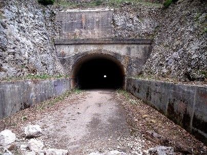
What Do Closed Mountain Roads Tell Us About Territories? A Critical Analysis ...   1

    What Do Closed Mountain Roads
    Tell Us About Territories? A Critical
    Analysis of Abandonment, Re-
    Appropriation and Valorisation in
    the Vercors (19th-21st Century)
    Emma-Sophie Mouret

    Introduction
1   Can closed mountain roads be considered heritage sites? For most mountain territories
    seeking an economic conversion to tourism, access has become a major issue. Road
    closures illustrate the changing uses and practices of local societies for whom the road no
    longer meets their needs. Can we still talk of heritage sites? Since the middle of the 20th
    century, the number of heritage sites has increased to the point of raising land-use issues
    and examination within the academic community. Military, industrial and commercial
    are the designations applied to these abandoned sites based on their original functions
    (Janin, Andres, 2008). The territories that are left behind are defined as “heritage sites”
    representing social and economic change (Raffestin, 2012). Moreover, abandoned roads
    are a precious source of information about their former use, as well as an indication of
    their contemporary vocation. The roads symbolised modernity when they were built and
    obsolescence when they were closed.
2   The Vercors mountain range is an interesting example. The lowlands and the highlands
    experienced the effects of the state’s modernisation policies along with new road-
    building technology in the middle of the 19th century when a network of carriageable
    roads was constructed.1 These lands had previously been linked by non-carriageable
    roads.

    Journal of Alpine Research | Revue de géographie alpine, 107-1 | 2019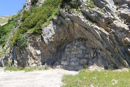
What Do Closed Mountain Roads Tell Us About Territories? A Critical Analysis ... 2
3 The roads that were built were categorised as “Chemins de Grande Communication” in
the department, depending on the departmental hierarchy established by the Service
Vicinal. They are famous for their staggering heights and have consistently appeared in
the literature on the Vercors. They are believed to have provided access to previously
autarkic societies. These roads were essential in shaping development on the local level.
They are hard to widen and were built on slopes prone to landslides. For this reason,
tunnels were built, and dangerous turns were widened. Abandoned roads were left to
slowly deteriorate. “Délaissés routiers” is the term used by local populations and elected
officials to refer to such abandoned roads. They are often left next to the newly built
roads and represent visible vestiges of development projects from years gone by. This
paper seeks to examine roads as heritage sites. Roads connecting ski resorts are
frequently abandoned and are a major part of Gauchon’s “landscape of heritage sites” (
Gauchon, 1997). Some of them, such as the Moucherotte gondola and, more recently, the
ski jumping ramp of Saint-Nizier (Bachimon, Bourdeau, Corneloup, Bessy, 2014), have
already been studied. The recent closure of the Grands Goulets road offered some insight
into the issue (Croze, 2004). However, the “délaissés routiers ” have not been studied by
the scientific community, even though it could be interesting to compare their
idiosyncrasies with other cases.
4 What are the characteristics of a mountain road heritage site? Its construction, closure
and management once it becomes a heritage site need to be considered. Is it abandoned,
re-used in other forms or considered a heritage site? And if so, how does it fit the memory
and perceptions of the Vercors? In order to study these questions over the long term
(19th–21st century), we examine archival work, nominal data, tourist documentation,
participant observations and oral surveys.
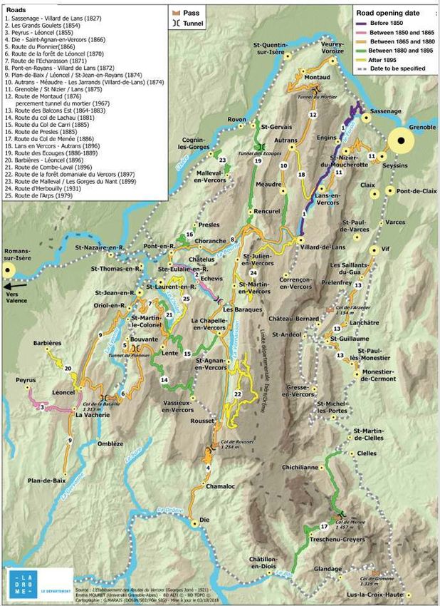
Figure 1: Main carriageable roads built during the 19 th century to access the Vercors range
Authors: Grégoire Marais, Emma-Sophie Mouret, 2018.
Journal of Alpine Research | Revue de géographie alpine, 107-1 | 2019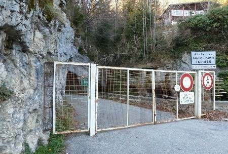
What Do Closed Mountain Roads Tell Us About Territories? A Critical Analysis ...   3

    The road: a sign of territorial changes
    Roads as drivers of and brakes on territorial evolution

5   Roads make it possible to understand territorial change. In the Vercors mountain range,
    they have been one of the main parameters related to economic growth since the 19th
    century.2 The shift from mule roads to carriageable roads was carried out mainly to
    improve the exploitation of state-owned forests. Thus, the former forests’ exploitation
    experienced some changes (Hanus, 2000), since carriageable roads were better suited to
    transporting greater amounts of wood. The route planning of these roads followed the
    mountain reliefs and the location of state-owned forests.3 That was the case with the road
    from Die to Saint-Eulalie-en-Royans (1866), Les Écouges road (1883) and the Combe Laval
    road (1896).
6   When these roads opened, they rapidly attracted tourists and became tourist roads
    between the 19th and 20th centuries. Road-related tourism represents a resource for both
    inhabitants and external actors. Consequently, activities such as hotel services,
    transportation and road maintenance were developed and integrated into local working
    practices. This led to changes in the socio-economic systems. An interesting example is
    the hamlet of Barraques-en-Vercors (Hameau des Barraques-en-Vercors). This tiny
    settlement is located at the beginning of the Grands Goulets road; it appeared on the land
    registry for the first time in 1861. At first, an innkeeper and a road-mender settled into a
    former road worker house, and by 1872, 28 inhabitants had taken up road- or tourism-
    related jobs.4
7   This road-related tourism was particularly active until the Second World War. At the end
    of the 1940s, a particular kind of memorial tourism related to remembering the war
    emerged, especially in the southern part of the mountain range (Vergnon, 2002). Visitors
    also used these roads to train for mountain sports and engage in leisure activities. Their
    popularity rapidly increased during the Winter Olympic Games held in Grenoble in 1968.
    In this context, several road works began, especially in the northern part of the Vercors,
    such as the Mortier tunnel that was dug in 1967. This is proof of a new way of relating to
    the mountain between the 1960s and 1980s that was especially characterised by winter
    tourism (Lorenzetti, Delmenico, 2017). As a result, these places became access roads for
    everyday use. This tendency grew in 1970 with the creation of the Vercors Regional
    Natural Park, which drew new tourists and consequently required roads that would offer
    fast and safe access to the highlands. Thus, the notion of speed became a central issue –
    one that was and still is at the heart of the debate around road building and maintenance.

    A constant search for speed and mobility

8   The concepts of speed and distance are deeply connected and represent key parameters
    in the history of mountain paths.5 A road is perceived as obsolete if it no longer provides
    fast access. Indeed, with the new Vercors roads network completely re-designed, a reset
    of access and proximity between villages is observed.
9   Nowadays, the speed of access to the Vercors highland and the safety for those using the
    roads is regarded as a development factor. In this context, landslides on roads cause some
    disruptions to the flow of traffic. In order to avoid these events and the risks associated

    Journal of Alpine Research | Revue de géographie alpine, 107-1 | 2019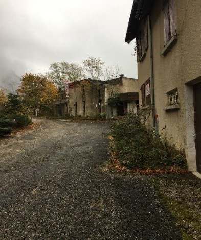
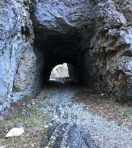
What Do Closed Mountain Roads Tell Us About Territories? A Critical Analysis ...   4

with them, new road layouts have been created: The well-known Grands Goulets road was
closed in 2005 and replaced by a tunnel in 2008. The first Col du Rousset tunnel, situated
on the road from Die to Sainte-Eulalie-en-Royans, was dug in 1866 and closed in 1979. In
this same year, a second tunnel, on a lower level, was opened that is accessible all year
round. Lastly, the Mortier tunnel was closed in 1992, due to a landslide on the road
leading up to it.6

Figure 2: Some of the closed roads and tunnels in the Vercors

Picture 1: Entrance to the Mortier tunnel
Photo:Valerco, 2017.

Picture 2: Les Écouges road: abandoned part on the left, tunnel on the right.
Source: http://www.gite-la-source.com/gite-activ-nanecouges01-impr.html

Journal of Alpine Research | Revue de géographie alpine, 107-1 | 2019
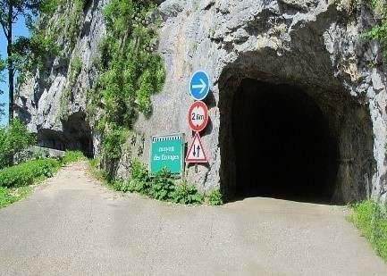
What Do Closed Mountain Roads Tell Us About Territories? A Critical Analysis ...   5

Picture 3: Gorges de la Bourne: Arbois tunnel on the left and an abandoned section on the right.
Photo: E. S. Mouret, 2015.

Picture 4: Walled entrance of the previous Col de Rousset tunnel
Source: http://courantsd-aire.over-blog.com/2014/08/infidelite-dromoise-54-souvenirs-du-
vercors.html, 2014, accessed in March 2018.

Journal of Alpine Research | Revue de géographie alpine, 107-1 | 2019
What Do Closed Mountain Roads Tell Us About Territories? A Critical Analysis ...   6

     Picture 5: Closed entrance of the Grands Goulet’s road.

     Picture 6: Abandoned tunnel on the Combe Laval road.
     Photo: E.S. Mouret 2018.

     The consequences of a road closure

10   The closure of a mountain road may be detrimental to a road-related tourism economy.
     Because of legal and economic reasons (Croze, 2004), the Grands Goulets road did not re-
     open after the new tunnel was inaugurated, although the General Council of the Drôme
     (Conseil general de la Drôme) had previously announced otherwise. Therefore, the
     activity of the tourist village of Barraques-en-Vercors has changed. This is an example of
     how road-related tourism and daily road use cannot always be combined. The owner of
     the Grands Goulets Hotel subsequently sold it, and at present, the hotel is only partially

     Journal of Alpine Research | Revue de géographie alpine, 107-1 | 2019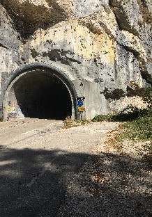
What Do Closed Mountain Roads Tell Us About Territories? A Critical Analysis ...   7

     open. Other hotel establishments created by and for the road-related tourism have also
     closed.

     Figure 3: Hotel restaurant “le Refuge” near the Grands Goulets tunnel

     Photo: E.S. Mouret.

11   The closure of this road completed a process started some decades earlier with the
     decline in road-related tourism in the southern Vercors. It became increasingly difficult
     to ensure the different uses of this road, such as daily trips, wood transport and tourism, 7
     and, as a result, these places slowly become “tourist wastelands” (Gauchon, 1997).

     Invisibility and appropriation of closed roads
     From closure to abandonment

12   The closure of a section of road leads to it being abandoned. The economic worth of open
     roads is well illustrated by this statement from a tourism professional in the Vercors. An
     abandoned section of road is a portion of the road that still ‘exists’ while disappearing
     from the visitor’s point of view. 8 When they are closed, they no longer appeal to tourists.9
     The municipality of La Chapelle-en-Vercors can be taken as an example: On its website,
     the Grands Goulet tunnel is described as “the longest tunnel of the Drôme department:
     1,700 metres in length, inaugurated on 28 June 2008.”10 The modern infrastructure is
     highlighted, although nothing is mentioned about the historical character of the road.
     Furthermore, on the website of the Vercors Regional Natural Park, no information can be
     found about the Grands Goulets road nor about the Mortier tunnel.11

     Journal of Alpine Research | Revue de géographie alpine, 107-1 | 2019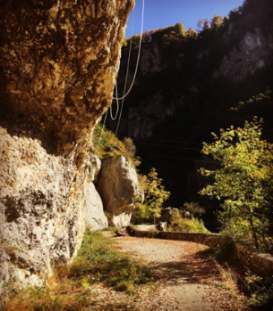
What Do Closed Mountain Roads Tell Us About Territories? A Critical Analysis ...   8

     Different forms of re-appropriation

13   These abandoned roads are re-used in different ways, however. Firstly, they serve as
     lookout points for drivers and bikers seeking to appreciate the landscape, take pictures
     and rest. On these roads, such resting places are sought after but few and far between
     because the roads are so narrow. Moreover, some of these closed roads are used for
     climbing practices (Fig. 6).
14   Firemen also come to practise climbing. In addition, the rocks could be useful for people
     doing environmental and geological analyses.12 In these same areas, the number of people
     practising drone activities is on the rise. Roads like the Mortier tunnel are also prized by
     cyclists. In the Grands Goulets, fishermen climb over the fences. Additionally, these
     closed roads are a topic of discussion for local politics. A plaque is fixed in the Gorges
     d’Arbois to commemorate a victim of a landslide in 2004. Some other tunnels are a
     meeting point for musical events like rave parties.13

     Figure 4: Rocks and climbing ropes on a portion of the Arbois road that is closed to traffic

     Photo: E. S. Mouret.

15   These unauthorised uses of closed roads are indeed re-appropriations, making the term
     “wastelands” no longer appropriate. Thus, can these particular ways of re-appropriation
     be considered a form of heritage?

     An ambivalent heritage
16   The term “heritage” here means “the part of the past that is worth being transmitted in
     order to find its value in the present” (Lazzarotti, 2003). However, it is essential that the
     actors’ ideas and opinions be considered in order to understand their aims insofar as they
     relate to heritage building (Rautenberg, 2000, Fagnoni, Gravari-Barbas, 2015). Since the
     second half of the 19th century, the Alps have been at the centre of heritage-centred

     Journal of Alpine Research | Revue de géographie alpine, 107-1 | 2019
What Do Closed Mountain Roads Tell Us About Territories? A Critical Analysis ... 9
policy. The most “archetypal” characteristics of Alpine societies have been emphasised
and sometimes even reduced to simplistic clichés. Some aspects of these societies, such as
their industrial heritage (Lorenzetti, Valsangiacomo, 2016), have been deliberately
forgotten. Very few initiatives concerning heritage have been carried out on the roads of
Vercors, even though their architectural aspects could justify an interest in them as
heritage. Nevertheless, mountain roads were conceived by (and for) societies, which
makes them architectural and social heritage (Hanus, 2016, Bernier, 2009). Some
communities in Royans have published heritage-related works on the roads of the
Vercors since the 1990s, but these works rarely cover the entire Vercors road system and
focus their attention on a departmental perspective. This last part demonstrates a
reflection on the complexity and the role of this roadway heritage in the way the Vercors
is remembered and represented.
Building roads and developing road-related tourism as decisive
initiatives
17 When a mountain road becomes heritage, some recurring themes appear, including
presenting its construction as the ultimate challenge that had to be overcome. The
economic benefits for the inhabitants resulting from the building process are also
highlighted. In 1983, the Vercors Regional Natural Park published a book entitled “Un
siècle de route en Vercors, aventure des bâtisseurs du Vercors : genèse d’un patrimoine”.
Improving access and facing a daunting challenge are important parts of such heritage-
related works. Documentaries and/or reports on the construction of mountain roads are
also available online.14 Road-related tourism is a recurring element in the discourse on
heritage, which presents it as a key moment in the history of these roads and, more
generally, of the Vercors. There is an emphasis on the sensational aspect of driving wood-
laden trucks and clearing snow on these roads.
18 At the same time, elements such as the inhabitants’ day-to-day lives and habits are
forgotten in this discourse. Their participation in the roadworks is documented to a much
smaller degree than that of the Italian immigrant workers, who symbolise the most
impressive accomplishments in Alpine transit. Most of the heritage-related works
concerning the Vercors roads have long followed a “departmental logic”. In 2017, the
Drôme department conceived of a heritage valorisation project for the Grands Goulets
and the Combe Laval roads, both of which have been listed sites since 1939 and 1991,
respectively. The agents of the DREAL (Direction Régionale de l’Environnement de
l’Aménagement et du Logement) recommended the same strategy for all Vercors roads.
The Vercors Regional Natural Park was in charge of the overall management of this
project. This was presented as a unifying project for the Vercors15 The purpose is to avoid
project failures such as a recent one involving an inter-communality project. The aim was
to unite the massif’s four different municipalities. The 2017 project attempts to refer to a
“broader” identity: the Vercors. The roads contributed to building the visibility of this
constructed territory (Sgard, 2001), which was subsequently bolstered by remembering
the role played by the Resistance (Vergnon, 2002, Wullschleger, 2004).
Journal of Alpine Research | Revue de géographie alpine, 107-1 | 2019What Do Closed Mountain Roads Tell Us About Territories? A Critical Analysis ... 10
Focus on open roads
19 The heritage discourse on the Vercors roads mainly concerns those that are open.
Nothing is said about the sections of closed road. The Mortier tunnel, the former Rousset
tunnel, Les Écouges or even the closed sections of Arbois and Combe Laval are not
mentioned in works related to heritage. Some records of local politicians and tourism
officers explain that they can’t be showed.16 These sections of abandoned roads contrast
sharply with green tourism and territories that are modern and otherwise appealing.
Furthermore, it can sometimes be a “trauma” for the affected communities (Janin,
Andres, 2008) when sections of road are declared to be out of service. From a territorial
marketing point of view, closed roads have a pejorative connotation. Thus, the most
emphasised element is the tunnel, which functions as a symbol of modernity and
progress, in contrast with the former road.
20 The example of the Grands Goulets is particularly striking. The closure of the “historical
road”, called as such by many inhabitants, represents a traumatic event for them. Today,
accessing it is strictly forbidden. Most of the inhabitants insist on the heritage and
memorial value of this road.17 Some local tourism professionals agree with them. This
concept is clearly explained by many videos online: “Who can remember the zeal
employed for the opening of the first road of Vercors in 1852? The new tunnel erased this
patrimonial journey. For all of those who won’t have the chance to see this road, this
tribute to the builders still remains”; “What a shame that it is no longer possible to visit
the old road, one of our heritage jewels.” Here, the will to make an abandoned road more
visible is considered a form of heritage building. Yet, it is forbidden to access the road,
and there has even been legal action against those who encourage others on social media
to access it.18 There have also been conflicts between different political and social actors
with regard to the road regulation policies. On several occasions, the department and/or
local communities have considered undertaking valorisation projects. These initiatives
were abandoned, however, because of the risk of landslides.19 In addition, the closed
section is used to access the tunnel for maintenance. Re-opening it would lead to the
presence of pedestrians and affect maintenance. In parallel, the closed section is also the
emergency exit. For this reason, the tunnel opening is closely linked to the risk of a
landslide. So, for many people, this closure appears to be a way to partially legitimise the
costs of digging the tunnel. However, many former users do not understand why the
Combe Laval road, which presents similar risks, is still open and is currently the focus of
heritage and tourist initiatives.
Challenge management?
21 Inhabitants drive on the Combe Laval road every day, and bikers and a large number of
cyclists also use it as frequently. Landslides are common and require rigorous and
complex maintenance activity. Therefore, an annual working plan has been established
by a departmental technician requiring the closure of the road. Nevertheless, alternative
routes are possible in the form of the Col de l’Echarasson road and the Arps road. This
kind of maintenance work has to be done during the off-season, but spring is not an
option since the work would interfere with the mating of the hawks living in the rocks of
the Combe Laval. Tourism hinders the possibility of these works being carried out in the
summer. The work, therefore, can only be done during a very short period in the autumn,
Journal of Alpine Research | Revue de géographie alpine, 107-1 | 2019What Do Closed Mountain Roads Tell Us About Territories? A Critical Analysis ... 11
on clear days.20 Furthermore, some masonry work to secure the mountainside is highly
criticised since it deteriorates the nature and the landscape. Its cost is criticised as well.
Figure 5: Cartoon about masonry activity in the Gorges de la Bourne, Serge Lombard, 2013
Source: http://www.initiatives-vercors.fr/humour-Les-travaux-des-gorges-de, accessed in April 2017.
22 The drawing represents the Gorges de la Bourne. The protective structures create an
oppressive effect. The writing refers to the well-known Land artists who ridiculed the
unsightly aspect of these constructions.
23 Closing the Combe Laval road for half a day has been discussed in the context of the
recent valorisation project for the Vercors roads. The aim is to return to a “slower
conception” of the roads (“retour à la lenteur”), which would allow only soft motilities in
order to “return the road to its users”21 (“rendre la route aux usagers”). But exactly what
kind of users are being considered? This initiative, launched by some tourism actors,
attempts to turn the road into an instrument of development associated with slow
tourism (Bourdeau, Marcotte, 2015). This kind of tourism is growing in the Vercors. 22 This
idea of “slowness” (lenteur) is based on wholly invented representations. Those different
uses are symptomatic of the multiple vocations of the road and, more broadly, of the
territory. Whether open or closed, the road appears as a conflicting object and can
generate new territorialities (Gal, 2016). A possible solution could be to implement those
initiatives in the already closed sections of the road – despite the many risks noted above.
Journal of Alpine Research | Revue de géographie alpine, 107-1 | 2019What Do Closed Mountain Roads Tell Us About Territories? A Critical Analysis ... 12
Conclusion: What is the story that closed mountain
roads can tell?
24 Mountain roads enable us to have a better understanding of territorial change. Modifying
or closing them suggests a change in the socio-economic development model, often
generated by the need to access the highlands more quickly and to be safe in transit. The
heritage left by the road network contributes to the “story” of the Vercors through
emblematic phases such as the opening up of the mountain range thanks to road-linked
tourism. Many of these elements are in use today, but at the same time, little is said about
the roads that are closed to the public. The silence on these closed roads is an omission
from history and the heritage of these territories. This tendency can be explained by
considering the Vercors’s image as a dynamic territory. As a result, talk about abandoned
roads stands in contrast with the strategy of marketing the territory. There is a
significant interest in determining the viability of these roads given the reality of possible
landslides, maintenance etc. Broaching the subject of road closings includes speaking
about the political and economic interests of the territory.
25 The weaknesses of defining a common approach to defining heritage illustrate the
broader issue of defining roads as a standalone historical topic. So, the question remains:
Which story do the local administrations want (to allow) closed roads to tell?
BIBLIOGRAPHY
Bachimon P., Bourdeau P., Corneloup J. et Bessy O., 2014.– « Du tourisme à l'après-tourisme, le
tournant d'une station de moyenne montagne : Saint-Nizier-du-Moucherotte (Isère) »,
Géoconfluences, avril 2014.
Belli-Riz P., 2002.– « Tourisme et automobilisme : de la route aux pistes », dans Revue de
géographie alpine, tome 90, n° 4, pp. 73-84.
Bernier X., 2007.– “Mountain roads as heritage objects : towards a typology of heritage status
development processes”, 11 th World Conference on Transport Research, June 24-28 2007 - University
of California Ed.- Berkeley CA – USA.
Blache J., 1931.– « Les massifs de la Grande-Chartreuse et du Vercors. Étude géographique » .
Thèse, Grenoble.
Blaise A., 2000.– « Mobilité et chemins en Vercors, autrefois », Jadis au pays des quatre montagnes,
généalogie et histoire locale, coll. « Les Cahiers du Peuil », n° 4, Méaudre, pp. 188-201.
Blanchard R., 1938.– Les Alpes occidentales. T.1. Les Préalpes françaises du Nord, dans Les Études
rhodaniennes, vol. 14, n° 2-3.
Bourdeau L. et Marcotte P. (dir.), 2015.– Les routes touristiques. Québec, Presses de l’Université
Laval, 254 p.
Journal of Alpine Research | Revue de géographie alpine, 107-1 | 2019What Do Closed Mountain Roads Tell Us About Territories? A Critical Analysis ... 13 Della-vedova G., (à paraître). – Les acteurs du développement rural en Isère : canton de Villard-de-Lans XIXe-XXIe siècles, thèse en cours d’édition. -“L’évolution et l’organisation du tourisme dans le canton de Villard-de-Lans (massif du Vercors) du milieu du XIXe siècle au milieu du XXe siècle », dans Marc GIGASE, Cédric HUMAIR, Laurent TISSOT, Le tourisme comme facteur de transformations économiques, techniques et sociales (XIX e -XXe siècles), éditions Alphil - Presses Universitaires Suisses, Neuchâtel, 2014, pp. 107-123. Favier R., 1993.– Les villes du Dauphiné aux 17 e et 18e siècles, Grenoble, Presses universitaires de Grenoble. Fillet P-L., 2009.– « Les routes du Vercors », p. 98-101, dans Conservation du patrimoine du département de la Drôme, Patrimoines du Royans-Vercors, paysages, architecture et histoire, département de la Drôme. Gal S., 2016.– « Montagnes et conflictualité : le conflit, facteur d’adaptations et d’innovations territoriales », Journal of Alpine Research | Revue de géographie alpine [En ligne], 104-1 | 2016. Gauchon Christophe, 1997.– « Anciennes remontées mécaniques dans les montagnes françaises : pour une géographie des friches Touristiques”, dans Bulletin de l'Association de géographes français, 74e année, 1997-3 (septembre). Didactique de la géographie. Aménagement et moyennes montagnes. pp. 296-310. Granet Abisset A-M., 2018.– « Et si la vitesse était la plus grande transformation pour les sociétés (de montagne) contemporaines ? » in Francesco Garufo, Jean-Daniel Morerod (éd.), Laurent Tissot, une passion loin des sentiers battus, Neuchâtel, Ed. Alphil-Presses universitaires suisses, 390 pages. Gravari-Barbas M. et Fagnoni E., 2015 .–, « Patrimoine et patrimonialisation, de l’objet à la relation », communication dans le cadre d’un Café géographique, Café de Flore, Paris, 24 novembre 2015. Hanus P., 2000.– « Je suis né charbonnier dans le Vercors » : petite histoire des hommes dans la forêt, Lans, Maison du Parc, 2000. Hanus P., 2007.–L'appel des Coulmes. Histoire d'une forêt du Vercors, Grenoble, Conservation du patrimoine de l'Isère-Musée dauphinois. Janin C., Andres L., 2008.– « Les friches : espaces en marge ou marges de manœuvre pour l'aménagement des territoires ? », dans Annales de géographie, 2008/5 ? (n° 663), pp. 62-81. Jorré G., 1921.– « L'établissement des routes dans le massif du Vercors » dans Revue de géographie alpine, tome 9, n° 2, 1921. pp. 229-284. Lorenzetti L., Delmenico D., 2017.– « La transition touristique d’une “station-village” Multipositionnalité et gestion foncière à Champéry (Valais) », 1870-1970 », Revue de géographie alpine 105-4 | 2017. Lorenzetti L., Valsangiacomo N. (dir.), 2016.– « Alpi e patrimonio industriale, Alpes et patrimoine industriel, alpen und industrielles Erbe », Mendrisio, Accadelia di Architettura. Parc Naturel Régional du Vercors, 1983.– Un siècle de routes en Vercors : le roman des routes du Vercors, voies de pénétration et sites remarquables, l’établissement des routes en Vercors, Grenoble, La manufacture. Raffestin C., 2012.– « Une société de la friche ou une société en friche », dans Revista Movimentos Sociais e Dinâmicas Espaciais, Recife : UFPE/MSEU, v.01, n. 02, 2012. Journal of Alpine Research | Revue de géographie alpine, 107-1 | 2019
What Do Closed Mountain Roads Tell Us About Territories? A Critical Analysis ...   14

Rautenberg M., 2003.– Comment s'inventent de nouveaux patrimoines : usages sociaux, pratiques
institutionnelles et politiques publiques en Savoie. In : Culture & Musées, n° 1. Nouveaux regards
sur le patrimoine (sous la direction de Jean Davallon) pp. 19-40.

Rautenberg M., Micoud A., Marchenay P., Berard L., 2000.– Campagnes de tous nos désirs : patrimoine
et nouveaux usages, Éditions de la MSH, pp. 194.

Sgard A., 1997.– Paysages du Vercors : entre mémoire et identité, Pézenas, Domens.

Sgard A., 2001.– « Vercors, l’invention d’un territoire », in ALPE, la revue du Musée Dauphinois
numéro hors-série « Vercors en question », Glénat.

Vergnon G., 2002.– Le Vercors, histoire et mémoire d’un maquis. Paris, Les Éditions de l’Atelier.

Wullschleger M. 2004.– Le Vercors : forteresse ouverte, Collection Les Patrimoines, Éditions Le
Dauphiné.

Mémoires de Master

Croze É., 2004.– « D’une route à l’autre : continuité du discours sur l’ouverture de la “forteresse
Vercors”. “Les Grands Goulets”, la route pittoresque du Vercors central », mémoire de master
sous la direction d’Anne-Marie Granet-Abisset, 2004.

Rochas Aurélien, 2015.– « Le Vercors : théâtre d’une bataille des routes (an X-1920).
Transformation et accessibilité du territoire des Quatre-Montagnes iséroises par le Chemin de
Grande Communication n° 6 de Grenoble a Villard-de-Lans par Sassenage et les Gorges
d’Engins », mémoire de recherche sous la direction d’Anne-Marie Granet-Abisset, 2015.

NOTES
1. This is the Saint-Simonianism way of thinking.
2. These are complex socio-economic processes.
3. Archives Départementale de l’Isère, 14O3, Dossier 1855, Rapport de l’agent voyer Chaumartin,
1855.
4. Archives Départementales de la Drôme, 6M448, Recensements de la commune de Saint-Martin-
en-Vercors.
5. The historian Anne-Marie Granet-Abisset started an analysis on this topic. « Et si la vitesse
était la plus grande transformation pour les sociétés (de montagne) contemporaines? » in
Francesco Garufo, Jean-Daniel Morerod (éd.), Laurent Tissot, une passion loin des sentiers battus,
Neuchâtel, Ed. Alphil-Presses universitaires suisses,2018.
6. The Gorges d’Arbois were mentioned by the geographer Xavier Bernier.
7. It was highlighted by various oral surveys.
8. Oral survey conducted in 2017.
9. On the inspiration Vercors website’s “routes panoramiques” section, nothing is said about
Grands Goulets road or the Mortier tunnel https://www.inspiration-vercors.com/destinations/
routes-panoramiques#road-49 consulted in December 2017.
10. http://www.lachapelleenvercors.fr/556/ consulted in February 2018.
11. http://parc-du-vercors.fr/fr_FR/les-actions-1109/patrimoine-et-culture-1452/connaitre-et-
valoriser-les-patrimoines-1453.html, consulted in February 2018.
12. Oral survey conducted in July 2018.
13. http://www.bassexpression.com/viewtopic.php?id=2287, consulted on 10 March 2017.
14. Wobook made for safety works of the Gorges de la Bourne in 2014 https://www.wobook.com/
WB6Y2Ge7Y517-2-a/Gorges-de-la-Bourne-vuedici-org/Page-2.html.

Journal of Alpine Research | Revue de géographie alpine, 107-1 | 2019
What Do Closed Mountain Roads Tell Us About Territories? A Critical Analysis ...   15

15. Oral survey conducted in February 2018.
16. Oral survey conducted in November 2017.
17. All oral surveys conducted since 2015.
18. Oral survey conducted in July 2018.
19. Oral survey conducted in February 2018.
20. Oral survey conducted in July 2018.
21. Oral survey conducted in February 2018.
22. For example, “Slows days” organised in Corrençon-en-Vercors in September 2018.

ABSTRACTS
In the Alps, mountain roads offer clear examples of the 19th-century policy of modernising road
networks. In the middle of the 1800s, the Vercors mountain range in the French departments of
Isère and Drôme was criss-crossed by a network of carriageable roads. Most of these roads were
built to transport wood but rapidly became tourist routes. After the Second World War, the roads
started being used more and more as daily transit increased. At the end of the 1970s, however,
the risk of landslides was increasingly becoming an issue. Some of the roads were closed
following landslides or after the construction of safer and faster roads. At the time they were
built, these roads were symbols of modernity. Later, as they became obsolete, they came to
embody both the development strategies of territories and the legacy of former policies of
modernisation. Now, this closed roads aren’t showed alongside other “magnificent roads”.

INDEX
Keywords: road, mountain, territory, wasteland, heritage, speed, risk

AUTHOR
EMMA-SOPHIE MOURET
Doctoral student in Human, Political and Territorial Sciences, LARHRA (UMR 5190) - ARC 7 région
Auvergne Rhône-Alpes, Université Grenoble Alpes.
emmasophiemouret@gmail.com

Journal of Alpine Research | Revue de géographie alpine, 107-1 | 2019
You can also read