White Clay Creek Action Plan (WCCAP) - By: Holly Cobb, Sophia Talley, Abbie Pierson, Megan Bittle - Water Resources ...
←
→
Page content transcription
If your browser does not render page correctly, please read the page content below
White Clay Creek
Action Plan (WCCAP)
By: Holly Cobb, Sophia Talley, Abbie Pierson, Megan Bittle
Mission Statement
The White Clay Creek Action Plan (WCCAP) aims to preserve the watershed’s
unique and valuable natural resources (such as biodiversity of both vegetation and
animal life and its use as a quality drinking water source) from human development,
making actionable progress by 2030.
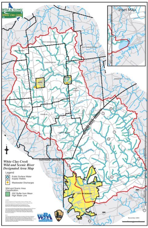
Map
Background & History
● The White Clay Creek Watershed:
○ Spans from Chester County, PA down to Newark, DE
○ Has approximately 95,000 people living within the watershed
○ Has a total mileage of nearly 200 miles
○ Was initiated as part of the National Wild and Scenic River System (NWSRS) in 2000
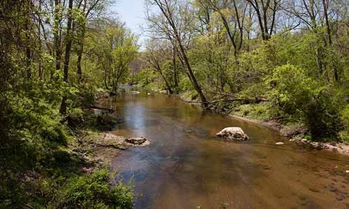
● Why is it important?
○ Historical significance - the watershed is home to water mills and early industry
○ Cultural significance - natural beauty and recreational value for the community to enjoy
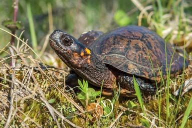
○ Ecological significance - home to threatened and endangered species such as the bog turtle
○ Natural resource significance - a major source of drinking water for population in the
surrounding areaPolicies & Mandates
- Overseen by: White Clay Watershed Association, National Wild and Scenic
River System, and National Park Service of Philadelphia
- Goal: to preserve and improve watershed quality
- State of Watershed report from 2016 focuses on:
- Threats toward open spaces with great preservation potential and increased erosion due to increase in
population and human development
- Indicators of habitat damage
- Unsatisfactory water quality (high Nitrogen concentration and high TSS)Problem 1: Eroding Stream Banks
- Decaying of surface by natural events or direct human activities
- Wind, waterflow, changes in temperature and pressure, surface cracks, drying surface, etc.
- Can lead to land loss, increased TSS, decaying structure, and increased
contaminants and water quality issues
- In WCC:
- Banks with trees erosion rates: 12.5 cm/year
- Banks without trees erosion rates: 9.9-36.1 cm/yearProblem 1 Goals & Actions Goal 1: Decrease the erosion rates at the White Clay Creek in order to prevent more serious long term effects by planting more trees and native species. - The overall goal is to decrease the erosion rates by 25% by 2030 by utilizing simple methods. - Planting native species provides extra support in the bank through the roots - More trees allow for more cover which leads to lower erosion rates
Problem 2: Decreasing Biodiversity
●   Biodiversity: the variety of life within an ecosystem
●   Factors such as poor water quality and habitat degradation contribute to
    decreasing biodiversity, potentially leading to species extinction or ecological
    collapse
●   From the 1980s-1990s, many areas within the WCC watershed (particularly
    Newark) experienced a housing boom that required the clearing and
    development of land
● WCC watershed, in particular, struggles with:
     ○   Land development threatening habitats
     ○   A lack of funding/initiative into sampling and research endeavors
Problem 2 Goals & Actions
Goal 2: Continue efforts to preserve natural and undeveloped lands (particularly forests
and streams) that serve as homes for native organisms. Support and fund efforts for
regular sampling and research into wildlife populations and their preservation.
● According to the White Clay Watershed Association, 3 out of 8 ecological indicators
could not be assessed because there was no available data. By 2030, integrate
ecological sampling into water quality assessments already being done
● Support/fund initiatives such as Partnership for the Delaware Estuary’s Freshwater
Mussel Recovery Program, that targets threatened populations with organized and
researched approaches (possibly using a program like the Trout Stamps program)Problem 3: Nonpoint Pollution
● Nonpoint pollution: the culmination of pollutants from many different sources
running off into the White Clay Creek
○ poses the most danger to the health of the creek because it is much harder to identify and
control the source compared to point pollution
● Factors contributing to nonpoint pollution:
○ suburban sprawl
○ impervious surfaces
○ agricultural runoff
● Ultimately cause an increase in turbidity and nutrients like phosphorus and
nitrogen, damaging water quality and harming the ecosystemProblem 3 Goals & Actions
Goal 3: Implement necessary actions such as redirection and treatment of runoff,
keeping livestock and agriculture away from water sources, and regulate future
impervious cover to reduce nonpoint pollution
● For future planning efforts (such as the NCC 2050 plan) limit suburban sprawl
and plan for more multi-use spaces
● Public land and county buildings can have more natural landscaping to prevent
stormwater runoff and instead have natural filtering (partner with programs
such as Catch the Rain)Conclusion
The White Clay Creek Watershed is a great resource that needs to be preserved for
the health and happiness of its inhabitants. In summary:
● Simple solutions like planting more trees and native plant species could lead to
decreased erosion rates
● Prioritizing research into local ecological and animal populations can help
monitor and improve biodiversity
● Redirection and treatment of runoff, keeping livestock away from water
sources, and regulating future impervious cover can decrease nonpoint
pollutionReferences Hartup, W., Lord, B., Patoprsty, W., Woodward, M., & Woofter, S. (2015). Small-scale Solutions to Eroding Streambanks. Retrieved 2021, from https://www.dconc.gov/home/showdocument?id=23130 McCarthy, K. (2018, April/May). RIVERBANK EROSION RATES IN THE WHITE CLAY CREEK WATERSHED, PA. Retrieved 2021, from https://udspace.udel.edu/bitstream/handle/19716/23798/McCarthy_udel_0060M_13337.pdf?sequence=1&isAllowed=y Newarkde.gov. 2021. History of Newark | Newark, DE - Official Website. [online] Available at: [Accessed 16 March 2021]. National Wild and Scenic Rivers System. 2021. White Clay Creek, Delaware, Pennsylvania. [online] Available at: [Accessed 3 April 2021] National Wild and Scenic Rivers System. 2016. White Clay Creek State of the Watershed 2016. [online] Available at: [Accessed 3 April 2021] White Clay Creek Wild & Scenic River. 2021. Resource Management and Protection Issues — White Clay Creek Wild & Scenic River. [online] Available at: [Accessed 16 March 2021]. “White Clay Conservation: Community Solutions to Deter Pollution (U.S. National Park Service).” National Parks Service, U.S. Department of the Interior, www.nps.gov/articles/000/white-clay-conservation-community-solutions-to-deter-pollution.htm.
You can also read