A Science Strategy for EuroGOOS - DRAFT WHITE PAPER
←
→
Page content transcription
If your browser does not render page correctly, please read the page content below
EG14.46
                                                                    12 May 2014
                                                                    Version 2

                        A Science Strategy for EuroGOOS

                                   DRAFT WHITE PAPER

                       Nadia Pinardi, Johnny A. Johannessen, Jun She
                                            and
                                   The EuroGOOS SAWG

1. Introduction

Operational oceanography, including ocean monitoring, analysis, reanalyses and forecasting
is a branch of science that requires continuous implementation of the most advanced research
findings to comply with ocean user needs. Inherent to operational oceanography is also the
access to observations in near real time. Moreover, operational oceanography delivers
products and information that are crucial for the research community to pursue major
understanding and advance knowledge and technology in the marine sector.

Active feedback between research and operational services therefore needs to be enhanced,
maintained and secured since it is at the basis of a competitive development of services in
operational oceanography but also of new scientific and technological advancements. If the
link between services and science is discontinued operational oceanography will fail to deliver
the high quality products and services of a given standard required by the pressing
environmental problems.

European Operational Oceanography has been integrated in past decades through e.g., EC
Operational Oceanography Cluster projects and GMES/GEOSS projects such as MERSEA,
BOSS4GMES, ECOOP, MyOcean etc. This has led to ECOMF Consortium1 as a core in response
to Marine Service component in the EC Copernicus program 2015-2020 (Fig. 1). For the
scientific developments of GOOS and other IOC programmes, the UNESCO-IOC Medium Term
Strategy document has set the basis for period 2014-2021. GODAE, as a global effort for
operational forecasting, has contributed to both global and coastal/shelf sea operational
oceanography. GEOSS, on the other hand, provides a forum for connecting operational
oceanography to policy makers and societal needs at large. .

1 The ECOMF is at the moment an MoU between 14 European Partners: Mercator (FR), INGV
(IT), UkMetOffice (UK), BSH (DE), NERSC (NO), DMI (DK), CNR (IT), Puertos de l’Estado (ES),
HCMR (GR), SHMI (SE), CLS (FR), IFREMER (FR), MHI (UK), MetNO (NO)
At the European level, the Marine Board of the European Science Fundation (ESF) has recently
organised a foresight document that describes the European science and maritime policy
landscape, giving important priorities for operational oceanography developments.

The EuroGOOS Science Advisory Working Group (SAWG) is focusing its effort to maintain a
close connection between science and the national services, the European and international
operational oceanographic services, namely the Copernicus Marine Service
(http://www.copernicus.eu/pages-principales/services/marine-monitoring/), the GOOS
program (http://www.ioc-goos.org/), the other Regional Alliances developments and the
other international programmes such as JCOMM, GODEA, GEOSS and GCOS etc.

   Fig. 1. The ECOMF mission targeting the delivery of the Copernicus Marine Service with central
  functions (Cross-Cutting Functionalities), MFCs and TACs. Acronyms: Thematic Assembly Centers
  (TAC), Monitoring and Foecasting Centers (MFC), Central Information System (CIS), Global Ocean
(GLO), Arctic Ocean (ARC), Baltic Sea (BAL), North West Shelves (NWS), Ireland-Bay of Biscay-Iberian
   area (IBI), Mediterranean Sea (MED), Black Sea (BS), Sea Level (SL), Ocean Sea Ice, Sea Surface
                        Temperature and Sea Winds (OSI), Ocean Color (OC).

2. White paper Objectives

This white paper aims to address key scientific issues and research priorities for the
development of operational oceanography and analysis and forecasting capabilities in Europe
for the next 5-10 years. Knowledge gaps and deficiencies are discussed in related to common
scientific challenges in European marine forecasting technology, observing system
optimization, integrated service and other important areas of operational oceanography.

3. Relevant Research and Development issues for EuroGOOS

The science and technology innovation of EuroGOOS is driven by both user needs and
scientific State-of-the-Art. EuroGOOS partners conducts Joint Research Activities (JRAs)
through coordinating research in national, regional (ROOSs) and European (e.g. Horizon2020,
Copernicus Marine Service) levels, with focus on scientific challenges for Blue Growth and
European policy making in marine ecosystem, marine energy, navigation, bio-resources,
climate adaptation and mitigation and disaster prevention etc. EuroGOOS JRAs aims to
enhance European added-value in Blue-Growth, Climate Change Adaptation and marine
ecosystem health through European scientific innovation on optimizing European ocean
observation system, developing advanced forecasting technology and integrated services. This
will be a significant contribution to the implementation of relevant componenets in
Horizon2020.
Although European operational oceanography has experienced a significant advancement in
last two-decades, great challenges exist in order to serve fast growing marine economy and
make adaptation and mitigation measures to rapid changing climate and environment. The
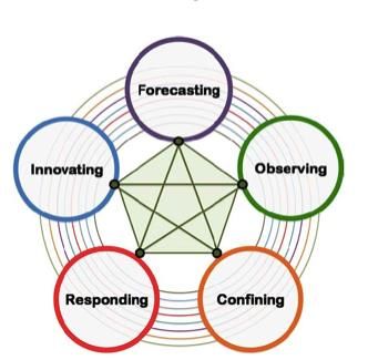
advanced science of ocean predictions is at the center of earth science challenges, as shown
in Fig. 2, together with innovation, observing, responding and confining the impacts.
Fig. 2. Schematic of grand challenges from the ‘Earth System Science for Global Sustainability’, ICSU
(2010)
The basic challenges for operational oceanography can be described as follows:
Cutting-edge forecasting technology is needed for seamless prediction which can resolve wide
range of spatial and temporal scales and parameters. It should be built upon an integration of
the advancement of model dynamic processes, numerical solutions, availability of good data
and their assimilation as well as efficient high performance computing. Currently forecast
quality of sea ice and biogeochemical parameters has to be improved to meet the user needs;
harmonized pan-European forecast is needed for policy making; a significant part of
observations in coastal and shelf seas has yet to be assimilated for forecasting; there also has
been a lack of high standard operational ocean models which can efficiently use multi-core
and many-core architectures.Cost-effective design of sustained ocean observing system is needed both in real time as well
as in delayed mode to provide quality assured data for process studies, model validation and
assimilation. Nowadays spatial and temporal coverage of ocean monitoring are highly
inhomogeneous, some areas are well covered but others with large gaps. There has been a
lack of quantitative assessment of the representativeness of the monitoring systems in
European marine waters. Due to high cost and limited resources in ocean monitoring, cost-
effective design is essential for optimizing the investment and planning next generation
observing systems. This should be investigated by combining knowledge of key ocean
processes, assimilation experiments (e.g. OSEs and OSSEs), monitoring technology and
statistic optimal design methods.
Quality of observations and forecasts is at the core of Marine Service. Identify the gaps of
state-of-the-art and user needs in the quality of products, characterize and estimate as
accurately as possible, and as far in the past as possible, the state of the ocean and the ice
covered seas from all information available and quantify uncertainties;
New knowledge, measures and methodology for assessing and predicting climate change of
marine environment and ecosystems are needed to understand changes and impacts of
human activities on the oceans and ecosystems to manage adaptation and mitigation with a
‘science based approach’; new applications have to be developed for the sustainable
management of resources using an ‘operational approach’.
Science and technology priority activities could be extracted to approach and partially solve
the challenges outlined above:
improve deterministic physical models and assimilation methods for open ocean and
pan-European seas and sea ice covered regions which can correctly resolve important
physical and coupling processes in wide range of scales with advanced high
performance computing;
extend the forecasting capabilities to marine biogeochemical components and marine
ecosystems at the appropriate spatial and temporal scales and include freshwater
runoff with transport of nutrients and suspended matter;
quantify and reduce uncertainties on the ocean and sea ice state variables (with a
transition from deterministic to ensemble predictions);
design, test and make sustainable a global and pan-European observing system
(satellite and in situ based), with cost-effective sampling strategy, innovative sensors
and components, to serve the real time needs of operational oceanography and its
applications at appropriate spatial and temporal scales to resolve the dominant
processes, interactions and mutual feedbacks; detailed knowledge should be
developed on how different monitoring platforms, assimilation and understanding of
dynamic processes can benefit each other to reach a cost-effective design of the
system.
understand how to use calibrated/validated operational models and products for
solving challenge problems in Marine Strategy Framework Directive, Blue Growth,
environmental and climate change scenarios. Tailored products, ‘what if scenario’
methodologies and new applications should be developed.
develop the information system that will catalog, discover and make feasible the
access to the ocean observations, models and new operational oceanography products
and information;
develop educational and training tools and activities.Specific scientific issues contained in these priority activities include:
1. Cutting-edge forecasting technology
(i) Rationalizing the range of forecasting models
(ii) Data assimilation improvements
(iii) Ensemble forecasting and uncertainty estimation
(iv) Generic aspects of coupling numerical models
(v) Extension of forecasts towards biological/ecological state variables
(vi) Efficient high performance computing
(vii) Extension toward long range ocean forecasting
2. Optimization of observing systems and use of observations
(viii) Assembling test-bed data sets
(ix) Exploitation of remote sensing data sets
(x) Development of monitoring strategies
(xi) Optimal design of observational networks (including OSSE)
3. User-oriented research
(xii) Marine Rapid Environmental Assessment
(xiii) Coastal operational oceanography, including coastal engineering
(xiv) Operational oceanography in ice covered seas
(xv) Dissemination: visualisation, analysis
(xvi) Training and education in Operational Oceanography
(xvii) Liaison with existing European & International agencies
In order to make significant progress in the coming 5-10 years with respect to these specific
scientific research issues funding opportunities must be explored nationally and
internationally (e.g. HORIZON2020 and ESA scientific support studies under DUE, STSE,
Sentinel and Explorer funding lines).Appendix A: Specific R&D issues (i) Rationalizing the range of forecasting models The transition from eddy-permitting (~1/4°) to eddy resolving (~ 1/12°) resolutions at basin- and global scales is now gradually achieved. For coastal applications, downscaling to eddy and strait resolving scales (~ 1/60° or finer) smoothly nested into basin-scale configurations must be developed. To resolve the finer scales (~ 1/60°), one has to develop new physical parameterizations and discretization schemes that can be adapted to the interactions of large- scale, mesoscale and coastal scales down to turbulence effects. In particular there are needs to gain understanding of effects of the sub-mesoscale part of the eddy spectrum not resolved by the operational systems and diapycnal mixing processes in the ocean’s interior (internal wave breaking), as well as other processes which are described in Priority (xiii). Research and development effort are also needed to enable advancement regarding temporal scales, notably: (i) improved short term predictions (forecasts) based on the best possible atmospheric forcing functions, (ii) qualified re-analyses (hindcasts) of the past variability on seasonal to decadal time scales, and (iii) prediction or projection of future statistics of high impact events, e.g., extreme events and offshore ocean energy etc.. The optimal reconstruction of the dynamical ocean using remote sensing and in situ measurements recorded during the past 20-50 years will require well-tuned systems including new developments to comply with the expected applications from the reanalysis. Specifically, the “smoothers”, 4D versions of statistical assimilation schemes, will progressively substitute the conventional 3D sequential schemes implemented today, as in hindcast mode both “past” and “future” data will be available for assimilation. In addition, the scope of re-analyses will gradually encompass the biological component coupled to the physical component. Advancement of numerical schemes are also relying on testing and implementation of high- order advection schemes, numerical treatment of side wall boundary layers using partial coast lines, specific dissipation schemes and improved open boundary conditions (for regional models). As 1/60° resolution means 125 timers heavier than the 1/12° setup, efficient high performance computing (“green” models) are essential. For European policy-making, pan-European harmonized forecasts and projects are needed while current forecasting systems are separated by the regional basins. Next generation models should be able to resolve European coasts, straits and inter-basin water exchange with sufficient resolutions and high quality. The research is also linked to Priorities (ii), (v), (vi) and (xiv). (ii) Data assimilation The reduction of uncertainties is a central challenge for operational modeling and services, which requires permanent innovations in data assimilation. Assimilation of multi-source water temperature, salinity, sea ice and sea level anomaly has been mature in open ocean operational forecasting. However, assimilation in coastal and shelf seas is facing more challenges for both physical and biogeochemical parameters. Improved forecasting quality in European coastal and shelf seas, in the Arctic and in ecosystem prediction greatly rely on efficient data assimilation. Present day assimilation approaches encompass a hierarchy of
methods of increasing complexity, ranging from optimal interpolation to non-linear stochastic
methods. Ensemble-based assimilation methods (including the EnKF and the SEEK filters) has
led to significant improvements in theoretical foundations and practical implementations. To
provide more reliable estimation of associated errors on the ocean state variables the
research and development effort needs to focus on:
    - Innovative assimilation methods: e.g., 4-D extension of statistical assimilation
        algorithms to comply with new operational products such as reanalysis of global ocean
        and regional seas; to improve atmospheric forcing using available observations via the
        ensemble Kalman filter and smoother; non-Gaussian extensions for non-linear
        transformations of probability distributions (lognormal or empirical polynomial fits,
        spatially or temporally varying transformations) to reduce data assimilation biases by
        more realistic stochastic models.
    - Data assimilation for coastal regions: stable operational schemes are needed to
        assimilate multi-source physical data from both satellite and in-situ observations (sea
        level, surface currents, temperature & salinity).
    - Assimilation of biogeochemical variables: to improve the quality of ecological state
        forecast and estimation by assimilating satellite chl-a and optics data as well as in-situ
        measurements
    - Assimilation of multi-source sea ice observations, including high resolution ice charts,
        ice surface temperature and ice thickness from Cryosat and SMOS, is needed to
        improve ice forecast
    - Assimilation schemes are needed for coupled atmosphere-ocean-ice system for
        improved forecasting in ice-covered waters

(iii)   Uncertainty estimation by ensemble and super-ensemble forecasting,

Atmospheric and oceanic ensemble forecasting is a way to deal with uncertainty related to
inaccurate knowledge of the initial state of the atmosphere and the ocean, the lateral and
vertical boundary condition errors and the model shortfalls (Lewis, 2005, Epstein, 1969). Since
the atmosphere and the ocean are extremely non-linear systems (Lorenz, 1963, Saravanan et
al., 2000) initial uncertainties can amplify and limit the predictability of short term forecasts
(Kleeman and Majda, 2005).

Ensemble forecast methods are well established in meteorology but much less in
oceanography. Traditionally initial conditions are perturbed and several forecasts are run
forming an ensemble of predictions used to study and calculate the probability distribution of
the forecasts. The different initial conditions are produced by perturbation techniques, some
of them very sophisticated (Cai et al., 2003). In complement, one may also perturb the
boundary conditions as is often done in oceanography (Barth et al. 2009; Melsom et al. 2012)
and turn model parameters into stochastic variables (Plant and Craig, 2008). Using these
methods the uncertainty in the predicted events of the forecast, typically jet stream
intensification, synoptic events moving across the domain of interest, are quantified in terms
of the ensemble variance. When the ensemble variance is high, the uncertainty in the
prediction is also high, indicating a sensitivity of the system to amplify small initial
perturbations. Ensembles can also provide a fully multivariate and flow-dependent covariance
matrix that can be used for data assimilation, as in the Ensemble Kalman Filter initially
proposed by Evensen (1994). A variety of practical implementations of ensemble techniques
for weather forecasts have been proposed (Toth and Kalnay, 1993, Molteni et al., 1996,
Houtekamer et al., 1996) and ensemble systems are now used operationally in weather forecasting centers (e.g. Houtekamer et al., 2009) as well as in operational oceanography (Sakov et al., 2012). Ensembles play a crucial role in providing probabilistic information on the forecast variables of interest, especially for difficult but important state variables such as precipitation, and they have a large potential for applications (Zhu et al., 2002). Operational oceanography is presently developing these methods for marine short term forecasting (Counillon and Bertino, 2009). On the other hand, multi-model ensemble forecasting is being developed in atmospheric forecasting that helps to evaluate uncertainty due to model errors provided there are no common error sources. Such techniques are now used to successfully evaluate climate change scenario experiments. Such methods should also be developed and explored for operational oceanography. (iv) Generic aspects of coupling numerical models Coupled processes between a variety of earth system components cannot be neglected in many cases. In ice covered seas (Arctic and Baltic), the diurnal and synoptic change of ice surface temperature is so large that the coupling of atmosphere-ocean-ice models is essential for both operational forecasting and climate simulations. Ocean-wave interaction has high impacts in the coastal and strait areas for prediction of water level, currents and waves. The climate science community will need to enter into a new era of climate information systems, which take into account the usefulness, provision, accessibility and quality of data. In order to maintain Europe’s leadership in this field and meet the challenges of climate change, significant progress is required in parallel in the development of both climate modelling and climate services. In H2020 - SC5_1 - 2014: High resolution Earth-system models funding opportunities are specified for global scale. There is still a lack of calls for pan- European scale coupled high resolution earth-system models. (v) Extension of forecasts towards biological/ecological state variables The maturity already achieved in global and regional ocean circulation needs to be extended in other aspects of the marine environment. Major challenges are to accurately estimate and forecast the distribution of marine bio-resources, and to provide real-time monitoring of global or basin-scale air-sea carbon exchanges. Specific research and development efforts need to be deployed to improve ecosystem process parameterizations, physical/biological interactions, forcing functions and integrated modeling systems with data assimilation capabilities. More robust approaches will be developed to extract key information from operational products to constrain the biological models, and also efficient methods to assimilate satellite ocean color data into predictive models. In particular improved ecosystem models to forecast small pelagic fisheries are relying on research and development of: - coupling functions between hydrodynamic/plankton models and Individual Bases Model (IBM) models; - incorporation of inequality constraints during the analysis phase of assimilation schemes (SEEK, EnKF, OI, 3D-VAR), - more accurate parameterizations and forcing functions (e.g. light penetration) of the coupled model equations using ocean color information (such as intrinsic optical properties, and possibly other in situ data) assimilation and parameter estimation techniques. A complementary demanding requirement in this respect is the access to data from an observing system that can capture the processes and interactions at appropriate spatial and temporal scales, hereunder also river fluxes and transport of nutrients and suspended matter.
Research and development of biogeochemical models for monitoring air-sea carbon fluxes are
also needed for inferring reliable pCO2 and carbon fluxes from ocean color data combined
with basin-scale models. Such models must reliably convert from ocean color measurements
of chlorophyll to carbon within the phytoplankton, account for sub-annual variations in upper-
ocean dissolved organic carbon, and link phytoplankton biomass to carbon export associated
with sinking.

A measure that is supporting new research and development in this particular field emerges
in HORIZON2020 under the call line H2020 – SC5_17 – 2014: Making Earth Observation Data
usable for ecosystem modelling and services (see Appendix B for further specific information)
and the call (still under discussion) targeting: BLUE GROWTH: UNLOCKING THE POTENTIAL OF
THE OCEANS - improving the preservation and sustainable exploitation of Atlantic marine
ecosystems [2015]

(vi)    Efficient high performance computing
It is essential to develop high standard ocean model code which is run2run reproducible and
can take advantage of up to date features of multi-core and many-core architecture, e.g.,
hybrid threading, SIMD vectorization and coprocessors. Next generation (coupled) ocean
models for European regional seas need high resolution in horizontal (e.g., a few hundred
meters) and vertical directions. Together with ecological and other coupled modules, the
model system will need thousands of cores to run. It is expected that most of the models have
to be significantly rewritten if they are going to be used on many-core computers.

(vii)   Extension towards long range forecasting
As a part of seamless forecasting, extension of short range forecasts toward long range and
the improvements of two-way interaction of operational oceanography and marine
environmental and climate change research are also relying on fundamental science.
Preliminary seasonal forecast experiments have been made in EU project OPEC for both
physical and biogeochemical variables in European regional seas. There are already research
findings on seasonal predictabilities in both physical ocean and marine ecosystems, e.g., in
Baltic Sea. Anomaly in the Arctic also contributes to extreme weather and ocean conditions in
seasonal and longer scale. To make successful seasonal forecast, fully coupled atmosphere-
ocean-ice-ecosystem model and assimilation techniques for the coupled system have to be
developed. The research under this topic is linked to Priorities (ii)-(vi).

(viii) Assembling test-bed data sets
The quality of ocean modeling products and services critically depend on the availability of
state-of-the art forcing, in situ and remote sensing input data sets. Major improvements in
data assimilation systems are expected thanks to the systematic use of new or improved data
sets (e.g. Argo T and S profiles, velocities from drifters and floats, ocean colour, high resolution
altimetry, GRACE and GOCE, SMOS, CRYOSAT, new SST sensors, SAR for sea ice). Research and
development activities for high level processing issues (validation, inter-calibration, error
characterization, development of new products) are mandatory for an effective use of data in
assimilation systems and/or for services. A European Sea test-bed database of bathymetry,
forcing (weather, river runoff, river loading, tides) and observations with uncertainty
estimates will largely benefit the oceanography community on ocean modeling and
assimilation research.
(ix)    Exploitation of remote sensing
Research and development efforts are needed to advance the error characterization of
satellite data, improve the synergy and merging of different satellite sensor data such as from
the Sentinels (in particular Sentinel 1, Sentinel 2 and Sentinel 3), and secure that recent
satellite sensor data such as from GOCE, SMOS and Cryosat are effectively assessed and
validated by the operational oceanography system. In this respect specific attention must be
paid to the HORIZON2020 Space call for 2014 and 2015, in particular the call for Earth
Observations including (a) space based applications, (b) tools for access to space data and (c)
climate change relevant monitoring and reprocessing.

(x)     Development of monitoring strategies
Monitoring technology (in-situ and remote sensing), sampling schemes, monitoring objectives,
modeling capacity, user needs and investment are key components in the monitoring strategy
design. For a given region, these components have to be considered as a whole. Qualitative,
ad-hoc design of monitoring strategies in each regional sea (link to ROOSs) is needed. Detailed
knowledge should be developed on how different monitoring platforms, assimilation and
understanding of dynamic processes can benefit each other to reach a cost-effective design
of the system. Delivery time vs. user needs should also be mapped and evaluated for both
physical and biogeochemical variables.

(xi)    Optimal design of observational networks
EU FP5-FP7 projects (e.g. ODON, ECOOP, JERICO and OPEC) have developed quantitative
assessment and optimal design methods for ocean observing systems. However, most of the
existing work has been limited to water temperature and salinity. Value of assimilating ocean
observations in operational forecasting should be systematically assessed and documented
for all European regional seas via Observing System Experiments (OSEs), especially for sea
level, ice and biogeochemical parameters. This value is, of course, just a relative measure as
quality of operational ocean models also matters. Results of OSEs will lead to suggestions for
further improvements of current observing systems, such as identifying and filling in the gaps,
improve the quality of observations etc. Observing System Simulation Experiments (OSSEs)
are expected to be more routinely applied for design of observational networks in the 2020
time frame. Statistical optimal design methods can be developed and combined with OSSEs.
Priorities (ii), (iv) and (vi) are linked to this action.

In HORIZON 2020 there is a special call line in BLUE GROWTH: UNLOCKING THE POTENTIAL OF
THE OCEANS targeting: developing in-situ Atlantic Ocean Observations for a better
management and exploitation of the maritime resources [2014]. It is highly necessary to take
advantage of this funding opportunities to advance the development and design of an
optimum observational network with particular focus on the in-situ aspect. Likewise it is
important to take benefit of the call line H2020 – SC5_18 – 2015: Developing and
demonstrating 'next-generation' in-situ community observatories. There is also an additional
specific call for coordination and supporting the strengthening of Earth Observation networks
which need action, notably: H2020 – SC5_19 – 2014/2015: Coordinating and supporting Earth
Observation research and innovation in Europe and in the North African, Middle East, and
Balkan region.

(xii)   Marine Rapid Environmental Assessment
In EU project OPEC, preliminary rolling reanalysis have been tested for European regional sea
ecosystems, which is called Marine Rapid Environmental Assessment (REA). The purpose is to
provide a rapid update of seasonal or annual marine and ecosystem states by assimilating all
the available online and offline data. It was found that availability of biogeochemical profile
observations (both due to lack of data and too long delivery time) and assimilation schemes
are the bottle-necks of the REA. The marine environment and ecosystem states are assessed
by a set of GES (Good Environmental Status) indicators derived from the rolling analysis. Since
the GES indicators are used in MSFD assessment, the REA method means an ‘operational
approach’ for the sustainable management of ecosystem resources which provides solid basis
for the future MSFD assessment. There are still knowledge gaps to be filled in deriving GES
indicators from REA simulations, and research is also needed to assess the quality of REA and
reduce uncertainties in rolling reanalysis.

(xiii) Coastal operational oceanography, including coastal engineering
Operational oceanography in coastal waters provide scientific and service basis for many Blue
Growth areas, e.g., coastal engineering and offshore operations, navigation, offshore wind
energy, disaster prevention, adaptation and mitigation to climate change. Coastal operational
oceanography has some unique features: e.g. high spatial resolution is required in all temporal
scales, two-way nesting is important, wave-ocean interaction is important, and there are
needs to gain understanding of: (i) processes governing variability in the surface layer (mixed
layer turbulence, interactions with air-sea fluxes) and linking surface wave, currents and
sediment resuspension; (ii) processes in the bottom boundary layer including resuspension
that are important, e.g., for the exchange of properties across shelf breaks and for the
behavior of dense sill overflows and better water column optics. Basin scale operational
models have to be adapted to serve these purposes.

(xiv) Operational oceanography in sea ice covered seas.
Better sea ice models based on a solid mechanical modelling framework are needed to
adequately represent the present sea ice state in coupled sea ice and ocean models. Currently
new development with wide scientific targets, from forecasting sea ice conditions in near real-
time to predicting the state of future Arctic climate (P. Rampal, NERSC) is currently taking place
based on a new Elasto-Brittle (EB) sea ice rheology that allows simulation of the very high
localization of sea ice deformation along so-called linear kinematic features (LKFs), and the
associated sea ice motion. The model is strongly constrained by both satellite and in-situ
observations of sea ice drift and deformation. An evaluation of the simulations is performed
using a metrics that take advantage of these observations. The observations are thus highly
critical for the development and assessment of this model.

The next step will be to fully couple the sea ice model to an ocean model. Further development
of the sea ice model also needs to evolve toward a full dynamic-thermodynamic sea ice model
in order to, for instance, adequately account for refreezing of cracks and solidification of
ridges. These remaining theoretical and technical modelling challenges highly rely on research
and mulitdisciplinary expertise in sea ice physics, sea ice-ocean physical interactions and
computational modelling. Complementary, there will also be need for research to:
(i)   sustain the development of current or new algorithms for sea ice tracking from SAR
      images;
(ii) improve the way available drift datasets are processed to retrieve sea ice deformation;
      (iii) process all the available satellite datasets (SAR) to generate one consistent
      Lagrangian ice motion dataset as well as an associated ice deformation dataset;
(iii) facilitate continuous processing of Sentinel 1A/B data in near real-time.
Network activity for Arctic /call in H2020
(xv) Dissemination: visualisation, analysis and tailored products
New technological platforms and innovative software have to be developed in order to make
the information and products of operational oceanography accessible. The amount of data
available and the challenges of displaying them in a form useful to many end-users is one of
the cornerstones of innovation in the field of data exploration and mining. Analysis tools
should be devised that bring together scientific ocean state estimates and forecasts and other
public sector information, including diverse topics such as demographics, health, economy
and crime so that users can develop their tailored products in a wide range of social benefit
areas.
In H2020 – SC5_16 – 2015: Strengthening the European Research Area in the area of Earth
Observation there is a very good opportunity to seek dedicated funding for the development
of comprehensive and sustained global environmental and information system. It is clear that
it is necessary to capitalize on this with respect to the need to develop and design a sustainable
marine observing system for climate and environment.
(xvi) Education and Training in Operational Oceanography
A potential obstacle for the development of operational oceanography and its support to
marine services and cutting-edge scientific research is the lack of scientists, engineers and
technicians with specific interest in this challenging and multidisciplinary area of research and
development. It is therefore necessary to initiate activities and program to attract the interest
of a significant number of students towards the field of operational oceanography. This issue
has been addressed in the HORIZON2020 Space call line COMPET 10 – 2014: Outreach through
education.
(xvii) Liaison with existing European & International agencies.
ESA Living Planet Program – Scientific Challenges
The scientific challenges specified in the ESA Living Planet Program is currently under revision.
It contains the following specification of priorities regarding ocean and sea ice research.
Quantify the interaction between variability in ocean dynamics, thermohaline
circulation, sea level, and climate.
Understand physical and bio-chemical air/sea interaction processes
Understand internal waves and the mesoscale in the ocean, its relevance for heat and
energy transport and its influence on primary productivity.
Quantify marine-ecosystem variability, and its natural and anthropogenic physical,
biological and geochemical forcing.
Understand land/ocean interactions in terms of natural and anthropogenic forcing.
Quantify the distribution of sea-ice mass and freshwater equivalent, assess the
sensitivity of sea ice to climate change, and understand mechanical behavior of sea ice
and thermodynamic and dynamic feedbacks to the ocean and atmosphere.
Quantify the mass balance of grounded ice sheets, ice caps, and glaciers, partition their
relative contributions to global eustatic sea-level change, and understanding their
future sensitivity to climate change through dynamic processes Quantify the influence of ice shelves, high-latitude river run-off and land ice melt on
global thermohaline circulation, and understand the sensitivity of each of these fresh-
water sources to future climate change
Moreover in H2020 – SC5_20 – 2014/2015 call line: Coordinating and supporting research and
innovation in the area of climate action, environment, resource efficiency and raw materials
there is an opportunity to create better transnational cooperation and coordination of
research and innovation policies, programs and initiatives in the area of climate action and
environment.You can also read