Aerial Photography using a Nokia N95
←
→
Page content transcription
If your browser does not render page correctly, please read the page content below
Proceedings of the World Congress on Engineering and Computer Science 2008
WCECS 2008, October 22 - 24, 2008, San Francisco, USA

             Aerial Photography using a Nokia N95
             Mariano I. Lizarraga† David M. Ilstrup∗ Gabriel Hugh Elkaim† James Davis                          ∗

    Abstract—A low cost UAV for aerial photography               improve the capabilities of “hobbyist level” systems. Au-
is constructed and tested. The UAV transfers images              topilots are now as cheap as $350.00 [2] but video down-
as they are captured via 802.11g to a ground station.            link capabilities and automatic high resolution image reg-
Photo-mosaics are immediately assembled using SIFT               istration/photomosaicing are generally far beyond the re-
keypoints for automatic image registration.                      stricted budget of such a project.
Keywords: Aerial Photography, UAV, SIFT                          In this project we develop a solution that provides high
                                                                 quality continuous (photo-mosaic) view from an aerial
1    Introduction                                                platform to small UAVs with small budgets, using a
                                                                 Nokia N95 wireless phone, a personal computer and open
The availability of current aerial imagery is important for      source or free software.
many applications. “Current” may mean a few minutes
for scenarios such as forest fire tracking, while a few hours     The aircraft is flown under pilot control from the ground
might be acceptable for missing person searches over a           while position, heading, and imagery from the phone are
region or intelligence gathering for military and law en-        received within seconds of image capture. The results are
forcement operations. Obtaining minutes- to hours-old            assembled into a photo-mosaic and geographically linked
aerial imagery has typically been a capability outside all       using a GoogleEarthTM KML file. If internet is available
but the most well funded organizations.                          on site, a visual overlay of the flight course is immediately
                                                                 viewable.
Unmanned Aerial Vehicles (UAVs) are often thought of as
strictly military devices, but in fact they are rapidly per-     The rest of this document is organized as follows: Sec-
meating the space of civilian applications (driven by lower      tion 2 presents previous work and how it relates to this
entry-level prices and a skilled and active community of         project. Section 3 describes in detail each component
remote/radio control (RC) airplane hobbyists). Current           of the system and how they interact. Section 4 shows
applications for UAVs include border surveillance, whale         flight test results. Section 5 presents conclusions, dis-
and other marine mammal tracking, power-line verifica-            cusses some of the weakness of this approach, and recom-
tion, and search and rescue missions in disaster areas [1].      mends some directions for further work.

Many of the commercially available UAVs are currently            2   Related Work
able to relay video and photographs to users on the
ground. The usefulness of the imagery that these flying           The idea of using a wireless phone inside an RC airplane
robots relay to their controlling ground station is directly     to take pictures is not new. The company Pict’Earth [3]
related to how much information the operator can “ex-            has a yet unreleased commercial proposal very similar to
tract” from the frames being watched. Image quality of           the one described here, but again, the price keeps it out
video relay, RF noise rejection, and image stabilization         of reach of the typical restricted budget. As evidenced by
have come to play important roles in the overall perfor-         the demo of their commercial product, the opportunity
mance measure of these missions.                                 for improved image registration exists.
While many of the mainstream UAVs have sophisticated             Image registration and photomosaicing of related imagery
equipment onboard to take care of these problems, the            from UAVs is an active research topic. Majumdar, et.al.
price tag has traditionally been on the order of millions        [4] presented a method for offline registration and mo-
of dollars, making them unaffordable for all but military         saicing of collected images from UAVs. This method has
applications.                                                    proven to give great results but is numerically intensive
                                                                 and somewhat slow. Instead, we make use of the open
Recent advances in solid-state sensors and overall reduc-        source Panorama Tools [10] to do the mosaicing of the
tion of the electronics have made it possible to greatly         flight images.
   ∗ University of California Santa Cruz, Baskin School of En-
                                                                 Our contribution is to provide a complete system to ac-
gineering, Computer Science Department davei@soe.ucsc.edu,
davis@soe.ucsc.edu. † Computer Engineering Department mal-       quire aerial images, geographically tag them, download
ife@soe.ucsc.edu, elkaim@soe.ucsc.edu.                           them via Wi-Fi to a ground station, and stitch them to-

ISBN: 978-988-98671-0-2                                                                                            WCECS 2008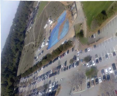
Proceedings of the World Congress on Engineering and Computer Science 2008
WCECS 2008, October 22 - 24, 2008, San Francisco, USA

gether to create a mosaic. All these steps are done with                                                                                3.1   Airplane Modification and Balancing
no intervention from the end-user aside from launching
the applications in the ground PC and the phone. If in-                                                                                 The first step to get the phone airborne was to modify a
ternet is available, the downloaded images as well as the                                                                               hobby RC airplane to be able to safely house the phone
airplane’s trajectory can be observed in a geo-referenced                                                                               inside its fuselage. For this purpose we tried two different
form in Google Earth. The system is based solely on open                                                                                airplanes: FlyZone’s SkyFly [6] and HobbyZone’s Super-
source or free tools and can be put together for as little                                                                              Cub [7], both shown on Figure 2. Both proved to be
as $170.00 for the RC airplane, assuming the end user                                                                                   sturdy and relatively easy to fly, but the Skyfly proved to
already owns the Nokia N95 phone and a wireless router.                                                                                 be under-powered and became very unstable in prelimi-
                                                                                                                                        nary flights with an attached 130 gm weight simulating
3    System Description                                                                                                                 the phone. The SuperCub was chosen for the main test
                                                                                                                                        flights at UCSC.
The complete setup, shown in Figure 1 consists of an
RC airplane that has been modified to hold the Nokia                                                                                     The SuperCub’s fuselage was modified to safely house
N95 wireless phone inside its fuselage (hand-launched and                                                                               the phone during flight (see Figure 2). Since the phone’s
controlled during flight by a pilot via radio control). Once                                                                             GPS antenna is located under the keyboard, the fuselage
the airplane is in the air, two applications run on the                                                                                 was molded to house the phone with the keyboard ex-
phone. One takes pictures and modifies their EXIF tags                                                                                   tended. Extra precautions were taken to keep the plane
[5] to include the GPS information; the other transmits                                                                                 aerodynamically stable.
them down to the ground station through a TCP socket
via 802.11g.

The ground station computer runs a server that receives
the images. These are handed off to a set of applications
which assemble mosaics from sets of three pictures. At
the time the pictures are received, the appropriate KML
files are also modified to display the received images and
update the flight path for display in Google EarthTM .
The wireless link between the computer on the ground
and the phone is serviced by a wireless (802.11g) router
with high gain (7dB) antennas.


                                                                                                                                "#


                                                                                                                                        Figure 2: Airplane Modification. Top Left: FlyZone’s
                                                                                                                  !

                                                                                                                                        SkyFly (left) and HobbyZone’s SuperCub. Top Right:


                                                                                                                               $      Phone installed in the housing. Bottom Left: Cover


                                                                                                                                        placed on the fuselage. Bottom Right: Balancing of the


                                                                                                                                        airplane


                                                                                                                                        3.2   The Phone Applications

                                                                                                                                        Two independent applications were developed for the
                                 Figure 1: Complete System Setup
                                                                                                                                        phone. A block diagram of these can be seen in Fig-
                                                                                                                                        ure 3. One is a Python script (PhoneApp.py) in charge
There are three main components to the overall system:                                                                                  of initializing the Camera and the GPS, taking pictures
(1) The modified airplane to fly with the phone installed,                                                                                and geographically-tagging them and saving them on the
(2) the applications residing on the phone itself, and (3)                                                                              SD card. The other is a Symbian OS SIS application
the set of applications comprising the ground station.                                                                                  (SendApp.sisx) that connects to the ground PC via Wi-
                                                                                                                                        Fi and periodically scans a local directory to determine
The following subsections describe each of the three main                                                                               whether a new picture has been taken. If so, it sends the
components in more detail.                                                                                                              picture to the ground PC and tags it as sent.

ISBN: 978-988-98671-0-2                                                                                                                                                                  WCECS 2008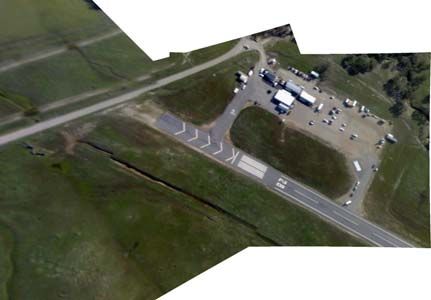
Proceedings of the World Congress on Engineering and Computer Science 2008
WCECS 2008, October 22 - 24, 2008, San Francisco, USA
PhoneApp.py SendApp.sisx
InitCamera InitWiFI Table 1: Mean and standard deviation for GPS accuracy
InitGPS OpenSocket
Log GPS Data
Mean Std. Dev
Take Picture Get New Picture Picture Taking Frequency 3.4886 0.8164
Modify EXIF Send Vertical Accuracy 28.1294 22.8255
Save File Tag as Sent Horizontal Accuracy 32.2818 21.0033
CloseGPS Close Socket
CloseCam CloseWiFi
autopano-sift [8] automatically establishes these corre-
SD Card
Flight Logs
spondences. It uses Scale Invariant Feature Tracking
Pictures
(SIFT) [9] to identify keypoints in each image. The iden-
Denotes Multiple
Executions
tified correspondences of the processed images are then
stored in a ’*.pto’ file which the ground station software
modifies slightly to insert Point Of View (POV) informa-
Figure 3: General Architecture of the Phone Applications tion specific to the phone’s camera.
Two tools from the Panorama Tools Library [10] are run
to find linear image transformations that minimize the
3.3 The Ground Station
distance error between keypoints (PToptimizer) and then
The ground station application (Figure 4) manages the to perform the image transformations (PTmender) re-
configuration of the host server for tagged image recep- quired to create the photo-mosaic.
tion, on-the-fly image registration and update of the flight
Finally, the Enblend application [11] is used to smooth
path in a KML file.
the pixel shading so the seams where images are joined
This is the first application run when starting a flight, become unnoticeable.
as the image server must be available when the camera
The application is robust, so that all available files will be
application begins image transmission. The ground sta-
processed even if a communication interruption occurs.
tions creates a unique flight directory to contain all flight
images, logs and KML files.
The main process of the ground station monitors the 4 Results
progress of the image server. When a new image has
been completely received, the KML file’s path informa- To test the complete setup several flights were completed
tion is updated and if sufficient files are available, image mainly in two locations: UCSC East Remote parking lot
registration, in sets of three, is performed. and in McMillan Airfield in Camp Roberts, CA. In the
following subsections we present our findings from these
flights.
4.1 GPS Accuracy and Picture Taking La-
tency
One of the key factors to successfully create a photo-
mosaic was the ability of the camera to take pictures
quickly enough so that pictures were able to overlap.
From the flight log we obtained data of how frequently a
picture was taken. Figure 5 shows a plot of the separation
(in seconds) between pictures.
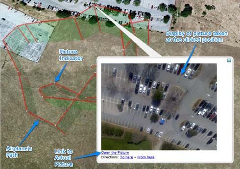
Since the information being presented in Google
EarthTM was very dependent on the accuracy of the
phone’s GPS module, then we decided to plot the data
Figure 4: General Architecture of the Ground Station from the flight logs to establish the expected accuracy
of the phone’s GPS. Figure 5 shows a plot of the verti-
cal and horizontal accuracy (in meters) of the GPS data
In image registration, perhaps the most interesting and collected. Table 1 shows the mean and variance of the
challenging aspect is establishing correspondence points image-capture frequency, vertical accuracy, and horizon-
or keypoints between images. The open source software tal accuracy of the GPS data.
ISBN: 978-988-98671-0-2 WCECS 2008
Proceedings of the World Congress on Engineering and Computer Science 2008
WCECS 2008, October 22 - 24, 2008, San Francisco, USA

                                                                                                                    phone take pictures from a stabilized platform notice-
                                  Time Separation (secs)

                                                           6

                                                           4                                                        ably improves the results. Finally as images are received
                                                           2                                                        Google Earth’sTM KML file is modified to display the last
                                                           0
                                                               0   10   20   30   40       50
                                                                                  Image Index
                                                                                                60   70   80   90   known position of the airplane and includes a link to the
                                                                                                                    image taken in that position. The image can be seen in a
         Vertical Accuracy(m)

                                        150

                                        100
                                                                                                                    pop-up “balloon” inside Google EarthTM or by selecting
                                                      50

                                                           0
                                                                                                                    the link in the figure, in a standard image viewer. Figure
                                                               0   10   20   30   40       50
                                                                                  Image Index
                                                                                                60   70   80   90
                                                                                                                    9 shows a screenshot of one of the flights.
         Horizontal Accuracy(m)

                                        150

                                        100

                                                      50

                                                           0
                                                               0   10   20   30   40       50   60   70   80   90
                                                                                  Image Index

Figure 5: Time separation between pictures. Vertical and
horizontal accuracy of the GPS

                                                                                                                    Figure 9: Airplane’s path displayed in Google EarthTM

                                                                                                                    5   Conclusions and Further Work
                                                                                                                    The system presented successfully takes aerial pictures,
Figure 6: Multiple pictures of UCSC’s east remote park-                                                             on average, every four seconds. Image registration to
ing lot                                                                                                             create the photo mosaics is reasonable provided that the
                                                                                                                    airplane is flying so that successive pictures overlap. The
                                                                                                                    presentation of the pictures and the mosaics in Google
                                                                                                                    EarthTM proves to be very useful to analyze the received
4.2    Aerial Imagery                                                                                               pictures.

Three flights tests with an average of two launches per                                                              Although we have presented a complete system that is
flight were performed in Fall 2007 on the UCSC cam-                                                                  able to take aerial pictures and create photo-mosaics with
pus. Figure 6 shows four pictures of UCSC’s east remote                                                             them, it is far from complete. Much work is needed on the
parking taken from the airplane.                                                                                    ground computer software. Three different scripting lan-
                                                                                                                    guages are currently used on the ground station (shell,
From the pictures taken in those flights it became clear                                                             Python and Perl) which ideally should be merged into
that the creation of the photo-mosaic was dependent of                                                              one. Currently there is no installer package to put these
the skill of the pilot to keep the airplane in level flight and                                                      tools onto a different computer than those used for devel-
on a straight line. Figure 7 shows a photo-mosaic assem-                                                            opment. The system remains a fragile prototype, suitable
bled from a set of pictures taken, with no user interaction.                                                        for research, but not yet ready for wide-scale deployment.
Although it is clear that the “stitching” is not perfect, it
is reasonable and clearly the end user can extract plenty                                                           System performance is best in straight and level flight,
of information from the view.                                                                                       which is difficult under manual control of the UAV. Re-
                                                                                                                    sults from the UAV flight confirm this observation.
Several flights tests were conducted during Winter 2008
at the McMillan Airfield in Camp Roberts, CA. Figure 8                                                               The image registration process is limited by the nature
shows a photo-mosaic produced from some of the images                                                               of the transformations used by the tools employed. Some
acquired during these tests which were done from one of                                                             method that takes account of parallax effects present in
the UAVs that is part of the Naval Postgraduate School’s                                                            images with large variations in ground distance would
Rapid Flight Test Prototyping System [13]. Having the                                                               also be an improvement.

ISBN: 978-988-98671-0-2                                                                                                                                             WCECS 2008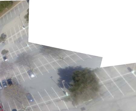
Proceedings of the World Congress on Engineering and Computer Science 2008
WCECS 2008, October 22 - 24, 2008, San Francisco, USA

Figure 7: Final panorama assembled from a picture triplet with no user interaction. East Remote Parking Lot UCSC

Adding roll and pitch to the current EXIF tags of the        [5] Technical Standardization Committee on AV & IT
images could potentially improve the process of image            Storage Systems and Equipment; Exchangeable im-
correction and registration.                                     age file format for digital still cameras: Exif Version
                                                                 2.2 , Japan Electronics and Information Technology
6    Acknowledgments                                             Industries Association, 2002.

Many thanks are due to Natasha Gelfand at Nokia Re-          [6] FlyZone,        FlyZone      SkyFly       Ready
search in Palo Alto, CA. Thanks to Isaac Kaminer,                to     Fly      Radio     Control      Airplane,
Vladimir Dobrokhodov, Kevin Jones, and Don Meeks at              http://www.flyzoneplanes.com/airplanes/
the NPS for their flight support and interesting ideas.           hcaa1961 index.html
Finally we profoundly thank Andrew Adams at Stanford
for providing us with a very efficient Python Module to        [7] HobbyZone, HobbyZone SuperCub Ready to Fly Ra-
make use of the phone’s camera. This work was partially          dio Control Airplane, http://www.hobbyzone.com/
funded by the Mexican National Science and Technology            rc planes hobbyzone super cub.htm
Council (CONACyT).
                                                             [8] Sabastian Nowozin,
                                                                 Autopano-Sift, Making panoramas fun,
References                                                       http://user.cs.tu-berlin.de/˜nowozin/
                                                                 autopano-sift/, University of British Columbia,
 [1] Nonami, K. ; Prospect and Recent Research & Devel-
                                                                 patents apply.
     opment for Civil Use Autonomous Unmanned Air-
     craft as UAV and MAV, Journal of System Design
                                                             [9] David G. Lowe, Distinctive image features from
     and Dynamics, Vol. 1, No. 2, 2007.
                                                                 scale-invariant keypoints, International Journal of
 [2] UNAV, LLC; Pico Pilot: World’s Smallest Autopi-             Computer Vision, 60, 2 (2004), pp. 91-110
     lot, http://www.u-nav.com/picopilot.html.
                                                            [10] Open Source Project, Panorama Tools - libpano13-
 [3] Pict’Earth,  World on Live:              Pict’Earth,        2.9.12, http://panotools.sourceforge.net/.
     http://www.pictearth.com/.
                                                            [11] Open Source Project; Andrew Mihal, enblend,
 [4] Majumdar, J., Vinay, S., Selvi, S.; Registration and        http://enblend.sourceforge.net/.
     Mosaicing for Images Obtained from UAV, IEEE
     International Conference on Signal Processing and      [12] Nokia, Python for S60,
     Communications (SPCOM), 2004.                               http://wiki.opensource.nokia.com/projects/PyS60.

ISBN: 978-988-98671-0-2                                                                                      WCECS 2008
Proceedings of the World Congress on Engineering and Computer Science 2008
WCECS 2008, October 22 - 24, 2008, San Francisco, USA
Figure 8: Panoramas assembled from picture triplets with no user interaction. Camp Roberts, CA
[13] Dobrokhodov, V.N. and Yakimenko, O.A. and
Jones, K.D. and Kaminer, I.I. and Bourakov, E. and
Kitsios, I. and Lizarraga, M.., New Generation of
Rapid Flight Test Prototyping System for Small Un-
manned Air Vehicles, in Proceedings of the AIAA
Modeling and Simulation Technologies Conference
2007.
ISBN: 978-988-98671-0-2 WCECS 2008You can also read