Aeronautical Study of Point Cook - December 2010
←
→
Page content transcription
If your browser does not render page correctly, please read the page content below
Aeronautical Study of
    Point Cook
      December 2010
Office of Airspace Regulation                                                      Page 2 of 26

DOCUMENT SPONSOR: OFFICE OF AIRSPACE REGULATION

PROJECT NUMBER:                      2011-20

TRIM REFERENCE:                      ED11/170589

FILE REF:                            EF11/6630

                                                  Document control:

            Version                 Issue/Nature of Revision          Date
            0.1                     Draft                                  July 2011
            0.2                     Incorporates internal feedback       August 2011
            1.0                     Incorporates industry feedback      October 2011

Aeronautical Study of Point Cook, December 2010                                        Version: 1.0
Office of Airspace Regulation                                                                                      Page 3 of 26

1           Executive Summary
This aeronautical study was commissioned in response to the Government‘s
expectation under the Australian Airspace Policy Statement (AAPS1) for the Civil
Aviation Safety Authority (CASA) to undertake regular and ongoing studies to meet
its obligations under Section 13 of the Airspace Act 2007 (Act). The Office of
Airspace Regulation (OAR) undertakes a risk based approach in determining which
locations are studied.
The purpose of the study is to review the airspace classification above Point Cook
aerodrome, Victoria (hereafter referred to as Point Cook). Particular emphasis is
placed on the safety of Passenger Transport2 (PT) operations.

1.1         Operational Context
Point Cook is on Port Phillip Bay approximately 17 nautical miles (nm) south west of
Tullamarine and 16 nm north east of Avalon. Point Cook was established as a
Military airfield in 1913 and was operational until the closure of No 1 Flying Training
School in 1993.
The Commonwealth of Australia, represented by the Royal Australian Air Force
(RAAF), still owns the Point Cook; however, there are no permanent RAAF flying
establishments on Point Cook and no Military controlled airspace associated with it.
The Commonwealth has ‘Deeds of Agreement for Airfield Use’ with approved
operators, and access to the airfield is limited to those authorised users of the
airfield. Whilst Defence remains as the Aerodrome Operator, Defence contracts
Airfield management to a private company; Rehbein AOS.
There are no Regular Public Transport (RPT) operations into Point Cook.

1.2         Issues
The OAR was made aware that movement numbers at Point Cook were in excess of
50,000 per annum. Subsequently, Avdata Pty Ltd was commissioned to record
monthly movements for the period May to August 2010. After annualising the
recorded data, the OAR concluded that movement numbers at Point Cook were in
the order of 80,000 per annum and therefore considered by the OAR to be relatively
high.
Accordingly, the OAR deemed it necessary to conduct a review of the aerodrome.

1.3         Findings / Conclusions

The site visit, stakeholder interviews, incident reports and modelling results indicate
that current procedures in place at Point Cook are appropriate. In the event that
traffic movement numbers substantially increase, or the usage of the aerodrome
changes, a further aeronautical study must be considered.

Should charter or other passenger services utilise Point Cook additional air traffic
management services must be considered.

1
  A full list of acronyms used within this report can be found at Annex A.
2
  For the purposes of this study, PT services can be defined as activities involving Regular Public Transport (RPT) and all non-
freight-only Charter operations.
Aeronautical Study of Point Cook, December 2010                                                                    Version: 1.0
Office of Airspace Regulation                                                                                     Page 4 of 26

1.4         Recommendations

It is important to note that the study may make recommendations based on existing
and projected data. The following comment as summarised by Chief Justice Sir Harry
Gibbs of the High Court of Australia has been considered while conducting the study:
          Where it is possible to guard against a foreseeable risk which, though perhaps
          not great, nevertheless cannot be called remote or fanciful, by adopting a
          means which involves little difficulty or expense, the failure to adopt such
          means will in general be negligent.3

CASA applies a precautionary approach when conducting aeronautical studies and
therefore the following recommendation is made:

      1. The OAR should maintain a watch of activity at Point Cook during the
         bi-annual review of movement data. If total aircraft movements significantly
         increase, or the mix of aircraft significantly changes, then an aeronautical
         study should be conducted to reassess the risk to operations.

3
 Gibbs, Chief Justice Sir Harry. Turner v State of South Australia (1982). High Court of Australia before Gibbs CJ, Murphy,
Brennan, Deane and Dawson JJ.
Aeronautical Study of Point Cook, December 2010                                                                   Version: 1.0
Office of Airspace Regulation Page 5 of 26 Contents 1 EXECUTIVE SUMMARY ............................................................................................3 2 INTRODUCTION ......................................................................................................6 3 AIRSPACE .............................................................................................................8 4 AERODROME .........................................................................................................9 5 CONSULTATION ...................................................................................................11 6 SUMMARY OF INCIDENTS AND ACCIDENTS ..............................................................15 7 AIRSPACE REFORM..............................................................................................17 8 AIRSPACE RISK AND OTHER AIRSPACE MATTERS ...................................................17 9 SUMMARY OF ISSUES ...........................................................................................21 10 FINDINGS AND CONCLUSIONS ...............................................................................21 11 CASA RECOMMENDATIONS..................................................................................21 12 REFERENCES ......................................................................................................21 ANNEX A – ACRONYMS................................................................................................23 ANNEX B – AUSTRALIAN AIRSPACE STRUCTURE ............................................................24 ANNEX C – STAKEHOLDER CONSULTATION / FEEDBACK REGISTER .................................25 Aeronautical Study of Point Cook, December 2010 Version: 1.0
Office of Airspace Regulation                                                      Page 6 of 26

2           Introduction
The Office of Airspace Regulation (OAR) within the Civil Aviation Safety Authority
(CASA) has carriage of the regulation of Australian-administered airspace, in
accordance with section 11 of the Airspace Act 2007 (Act). Section 12 of the Act
requires CASA to foster both the efficient use of Australian-administered airspace
and equitable access to that airspace for all users. CASA must also take into account
the capacity of Australian-administered airspace to accommodate changes to its use.
In exercising its powers and performing its functions, CASA must regard the safety of
air navigation as the most important consideration.4
Section 3 of the Act states that ‘the object of this Act is to ensure that Australian-
administered airspace is administered and used safely, taking into account the
following matters:
       a.      protection of the environment;
       b.      efficient use of that airspace;
       c.      equitable access to that airspace for all users of that airspace;
       d.      national security.’
2.1         Overview of Australian Airspace
In line with the International Civil Aviation Organization (ICAO) Annex 11 and as
described in the Australian Airspace Policy Statement (AAPS), Australian airspace is
classified as Class A, C, D, E and G depending on the level of service required to
manage traffic safely and effectively. Class B and F are not currently used in
Australia. The classification determines the category of flights permitted and the level
of air traffic services (ATS) provided. Annex B provides details of the classes of
airspace used in Australia. Within this classification system aerodromes are either
controlled (i.e. Class C or Class D) or non-controlled.
Non-controlled aerodromes in Australia are subject to Common Traffic Area
Frequency (CTAF) procedures. Pilots of aircraft operating at all registered, certified,
Military and CASA designated aerodromes are required to carry and use a Very High
Frequency (VHF) radio. Further information about aircraft operations at
non-controlled aerodromes can be found on the CASA website:
http://casa.gov.au/wcmswr/_assets/main/pilots/download/nta_booklet.pdf

2.2         Purpose
The study was initiated after the OAR became aware that the Point Cook aerodrome
(hereafter referred to as Point Cook) movement numbers were in excess of 50,000
per annum. Subsequently, Avdata Pty Ltd was commissioned to record monthly
movements for the period May to August 2010. After annualising the recorded data,
the OAR concluded that movement numbers at Point Cook were in the order of
80,000 per annum and therefore considered by the OAR to be relatively high.

4
 Civil Aviation Act 1988, Section 9A – Performance of Functions
Aeronautical Study of Point Cook, December 2010                                    Version: 1.0
Office of Airspace Regulation Page 7 of 26
The purpose of this aeronautical study is to review the airspace classification above
Point Cook and to demonstrate that all sensible and practicable precautions are in
place to reduce the risk to “As Low as reasonable Practicable” (ALARP). For this
reason a multifaceted approach was used, which included a quantitative and
qualitative analysis consisting of:
Stakeholder interviews,
Airspace Risk Modelling (relative modelling), and
Site visits.
2.3 Scope
The scope of the study includes identification and consultation with stakeholders to
gather necessary data and information related to airspace issues around the Point
Cook aerodrome. As a minimum, this includes consultation with Regular Public
Transport (RPT) operators, Charter operators, Flying Training Schools, Defence,
Emergency Services operators and the Aerodrome Operator.
The study’s scope must also consider CASA’s responsibilities in adopting a proactive
approach to assess the Australian airspace system and its operations, and to identify
and pursue airspace reform opportunities. The AAPS offers clear guidance to CASA
on the Government’s airspace strategy and policy, as well as processes to be
followed when changing the classification or designation of particular volumes of
Australian administered airspace.
The scope of this study is not intended to examine aerodrome facilities and
infrastructure issues unless any weakness or failings in these areas have a
significant impact on the safety of airspace operations in the vicinity of Point Cook.
2.4 Objective
The objective of this study is to examine the airspace around Point Cook to
determine the appropriateness of the current airspace classification. This was
accomplished by:
a. Investigating, through stakeholder consultation, the appropriateness of the
current airspace classification, access issues, instrument approach design5
issues, expected changes to the current traffic levels and mix of aircraft
operations within the existing airspace;
b. Assessing the opportunity to adopt proven international best practice
airspace systems adapted to benefit Australia’s aviation environment as
required by the AAPS6;
c. Analysis of current traffic levels and mix of aircraft operations within the
existing airspace in relation to the level of services provided;
d. Identifying any threats to the operations, focussing as a priority on the
safety and protection of Passenger Transport (PT) services;
e. Carrying out a qualitative and quantitative risk assessment of the current
airspace environment and the expected impact of any changes;
f. Identifying appropriate and acceptable risk mitigators to the known threats;
g. Reviewing extant Aeronautical Information Publication (AIP) entries for
applicability;
5
Refer to Civil Aviation Safety Regulation (CASR) Manual of Standards (MOS) Part 173.
6
To view the AAPS (2010) visit http://casa.gov.au/scripts/nc.dll?WCMS:STANDARD::pc=PC_90462
Aeronautical Study of Point Cook, December 2010 Version: 1.0Office of Airspace Regulation Page 8 of 26
h. Ensuring that the issues are passed onto the relative stakeholder group for
their consideration; and
i. Providing assurance to the Executive Manager of the Airspace and
Aerodrome Regulation Division of the levels of airspace risk associated
with operations at Point Cook.
The OAR issues a review of its Permanent Legislative Instruments on a bi-annual
basis. Any changes to airspace determined by this study with respect to airspace
classifications, air routes, prohibited, restricted or danger areas will be reflected in
these Instruments.
3 Airspace
3.1 Airspace Structure
Point Cook is a non-controlled aerodrome in Class G airspace with a dedicated
CTAF. Point Cook is surrounded by Danger Area (DA) D383, which has a vertical
dimension of surface (SFC) to Base of Control Area (CTA), and is active during hours
of daylight only. See Figure 1.
The airspace abutting Point Cook, or in near proximity, is complex and comprises of:
a. Class C controlled airspace;
b. Class D Control Zone (CTR); and
c. Class E controlled airspace.
Additionally, Restricted Area (RA) R361, which has the dimensions of 3 nautical
mile (nm) radius of Point Cook Aerodrome Reference Point (ARP), SFC to Base of
CTA. R361 is activated three times per week for museum flying displays and for large
events such as the Avalon Air Show and the Point Cook Pageant.
3.2 Airspace Management
The Commonwealth of Australia, represented by the Royal Australian Air Force
(RAAF), owns the Point Cook, however, there are no permanent RAAF flying
establishments on Point Cook and no Military controlled airspace associated with it.
Aeronautical Study of Point Cook, December 2010 Version: 1.0Office of Airspace Regulation Page 9 of 26
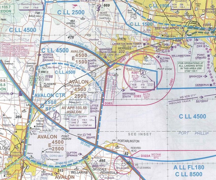
Figure 1: Point Cook (source – Visual Terminal Chart effective June 2011)
4 Aerodrome
4.1 Background
Point Cook was established in 1913 as the nation’s first Military airfield and remained
as an operational RAAF Base until the closure of No1 Flying Training School in 1993.
The Commonwealth of Australia, represented by the RAAF, still owns Point Cook
however, there are no permanent RAAF flying establishments on Point Cook and no
Military controlled airspace associated with it. The Commonwealth has ‘Deeds of
Agreement for Airfield Use’ with approved operators, and access to the airfield is
limited to those authorised users of the airfield. While RAAF remains as the
Aerodrome Operator, Defence contracts Airfield management to a private company;
Rehbein AOS.
4.2 Aerodrome Location and Layout
Point Cook is on Port Phillip Bay approximately 17nm south west of Tullamarine and
16nm north east of Avalon.
Point Cook has three runways, two asphalt and one grass. Additionally, there is a
grass Trike operating area to the east of RWY 17/35. See Figure 2 below.
Aeronautical Study of Point Cook, December 2010 Version: 1.0Office of Airspace Regulation Page 10 of 26 Figure 2: Point Cook Aerodrome Chart (source – Departure and Approach Procedures Aug 2010) 4.3 Airspace Users There are no RPT or Charter operations into Point Cook. There are 25 authorised users of the airfield, accounting for approximately 82 percent of traffic. The Royal Melbourne Institute of Technology (RMIT), based at Point Cook, is the most significant user of Point Cook, accounting for approximately 65 percent of traffic. Aeronautical Study of Point Cook, December 2010 Version: 1.0
Office of Airspace Regulation                                                 Page 11 of 26

4.4        Review of Aeronautical Information
A review of the Aeronautical Information highlighted an entry in En-route Supplement
Australia (ERSA) stating “RAAF Museum conducts flying displays within R361 TUE,
THU and SUN 1315-1345 Local Time, within 3nm of the ARP, SFC-3,000FT. Pilots
should check NOTAM for activation.”
This RA was established in an effort to provide a level of airspace segregation when
the RAAF Museum was conducting flying displays. The RAAF Base Aviation Safety
Officers (BASO) were able to show CASA evidence of ‘near misses’ during displays.
ERSA contains significant ‘Local Area Regulations’ which are designed to minimise
conflictions in the circuit area. Stakeholders interviewed were satisfied with the ERSA
entries and considered the procedures worked well with excellent compliance from
local operators.
There were no other issues noted with the Aeronautical Information.

5          Consultation
5.1         CASA
OAR representatives sought input from all authorised users of the airfield and other
stakeholders who operate in and around Point Cook. Stakeholder interviews were
conducted December 2010.
CASA Flying Operations Inspectors (FOI) from the region were contacted but no
issues were identified.

5.2        Aerodrome Operator
The Aerodrome Operator (RAAF) had no issues to report. The Aerodrome Operator
contracts day-to-day management of the airfield to the Airfield Manager.
The Aerodrome Operator, through the Airfield Manager, has to approve all flights in
and out of Point Cook that are not authorised users of the airfield. The Airfield
Manager is notified of the RMIT flying schedule and will halt additional traffic if
required to avoid overloading the circuit, however, this is rarely required.

5.3        Passenger Transport (PT) services
There are no PT services into or out of Point Cook.

5.4        Defence
32 Squadron (SQN), based at East Sale, is a regular user of Point Cook and advised
the following:
      •   For a departure from Point Cook, Melbourne ATC is usually very good at
          identifying aircraft and providing a quick clearance into CTA but, due to its
          proximity, the potential exists for a Violation of Controlled Airspace (VCA).
          Therefore, a departure could be improved with a Standard Instrument
          Departure (SID) that provides appropriate separation from CTA and
          terrain until cleared into CTA by Melbourne ATC. This may also reduce the
          incidence of VCAs.
          [CASA Comment: The traffic management for aircraft departing Point Cook is
          dependent upon the runway in use at Melbourne aerodrome. The current
          procedures utilised for aircraft departing into CTA involve controllers
          instructing aircraft to climb to 3,000 ft AMSL. Once the aircraft is identified
          above Point Cook, tracking information is provided.
Aeronautical Study of Point Cook, December 2010                                Version: 1.0
Office of Airspace Regulation Page 12 of 26
CASA cannot find any evidence to support the suggestion that a SID could
alleviate potential VCAs. Furthermore, due to the limited amount of traffic
departing point Cook into CTA, CASA does not support the creation of a SID
at this time.]
• The 32SQN Beech B350 has been changed to a C category performance
aircraft. While the 38SQN (based at Townsville) B350 is presently a
B category performance aircraft, they are likely to change to a C category
performance aircraft soon. As such, changing the Non-directional Beacon
(NDB) approach to include C category performance aircraft would greatly
assist access into Point Cook.
[CASA Comment: The Point Cook NBD has since become unserviceable and
will not be repaired prior to withdrawal.]
• An Area Navigation (RNAV) approach (designed for at least C category
performance aircraft) would also provide an alternative arrival option (as
opposed to the NDB) for aircraft trying to fit into a busy circuit pattern or during
Instrument Meteorological Conditions (IMC).
[CASA Comment: An RNAV approach procedure is being designed for Military
use only.]
• Increasing/introducing tower hours to facilitate arrival and departure of aircraft
during high density traffic periods should be considered.
[CASA Comment: This Study determined that the type and density of traffic
does not warrant a change in ATS or airspace.]
• Occasionally the circuit density is so high that Military aircraft conducting
contra circuits can have difficulty fitting into the traffic. Including a procedure to
give priority to a Military arrival or departure should be considered.
[CASA Comment: Point Cook is a non-controlled aerodrome in Class G
airspace with a Danger Area declared as a result of the sometime high density
of traffic. It is not appropriate to consider a procedure giving priority to the
Military.]
• Arriving from the North, in CTA, can leave little time or lateral space to
separate from high density traffic. A standard Visual Meteorological Conditions
(VMC) arrival procedure that procedurally de-conflicts traffic should be
considered.
[CASA Comment: Point Cook is a non-controlled aerodrome in Class G
airspace with a Danger Area declared as a result of the sometime high density
of traffic. It is not appropriate to consider a procedure giving priority to the
Military.]
• Most Military aircraft (including future acquisitions) should have Airborne
Collision Avoidance Systems (ACAS). Mandating the use of a transponder to
facilitate the identification of airborne traffic should be considered.
[CASA Comment: The equipage of avionics in Military aircraft is outside the
scope of this Study.]
The BASO is working on a plan to introduce an airspace booking system for the
locally based operators in an attempt to de-conflict local traffic.
Aeronautical Study of Point Cook, December 2010 Version: 1.0Office of Airspace Regulation Page 13 of 26 5.5 Emergency Services There are no Rescue Fire Fighting (RFF) or Emergency services on Point Cook. Emergency services are provided by local civilian agencies. 5.6 Air Navigation Service Provider (ANSP) Airservices Australia (Melbourne Terminal Control Unit and Avalon Tower) were consulted and had no issues to note. 5.7 Local Operators • RMIT RMIT is the major user of Point Cook and the surrounding airspace—accounting for approximately 65% of the traffic. RMIT programmers ‘de-conflict’ RMIT operations with other known planned activities. During school holidays, for example, when there are increased flying activities with Air Force Cadets, RMIT will schedule ground school to avoid the circuit area. RMIT thought the quoted statistics were too high and appear to be statistics for the peak periods such as school holidays. RMIT is limited to 120 students because of infrastructure issues but their number of students during the sample period totalled only 75. RMIT is using a system in the circuit whereby an aircraft calling base will also call their position in the sequence. This procedure has significantly improved flow and situational awareness. This procedure is described in ERSA. • RAAF Museum The Museum pilots expressed minor dissatisfaction with aircraft rejoining cross field when the Museum were conducting contra circuits. To provide additional separation the museum aircraft were flying slightly lower circuits. A planned amendment to ERSA will recommend that rejoining aircraft join the circuit not below 1,500 ft Above Mean Sea Level (AMSL). • Non-Museum Tiger Moth Operations The Tiger Moth operators prefer to conduct aerobatics overhead Point Cook because they believe there is less chance of confliction overhead. However, this is problematic when the circuit is active. An agreement was reached between the authorised users of the airfield that aerobatics overhead the airfield would be conducted not below 2,000 ft. Low level aerobatics would be conducted outside 3nm from Point Cook. A review of the procedure in July 2011 to remain outside the circuit area has changed. The agreement is now that Tiger Moth can do aerobatics within the circuit area provided it remains clear of other aircraft and vacates for aircraft on continuous circuits. • General There was consensus from the Stakeholders at the CASA site meeting that the majority of locally implemented procedures, listed in ERSA and designed to minimise conflictions, work extremely well. The authorised users of the airfield that attended the CASA site meetings were very satisfied with the level of traffic using the Point Cook airspace and did not perceive a need for any increased level of service. Aeronautical Study of Point Cook, December 2010 Version: 1.0
Office of Airspace Regulation                                                  Page 14 of 26

The authorised users of the airfield would also like to see the 2,500 ft AMSL CTA
step move towards Laverton to ease congestion for overflying traffic.
[CASA Comment: The area around Point Cook is heavily utilised by ATC to vector
Terminal Area traffic arriving and departing out of Essendon and Moorabbin.
Airservices has identified the change would infringe the profiles of aircraft on the
runway 34 approach and runway 16 departure at Melbourne aerodrome.]
The NDB is going to be de-commissioned and the approach procedure withdrawn
from Point Cook within the next two years. This will reduce traffic as civil aircraft will
no longer be able to conduct practice approaches at Point Cook. The RAAF is
designing a Global Positioning System (GPS) approach for use by Military traffic.
[CASA Comment: The Point Cook NBD has since become unserviceable and will not
be repaired prior to withdrawal.]

Aeronautical Study of Point Cook, December 2010                                 Version: 1.0
Office of Airspace Regulation                                                                         Page 15 of 26

6      Summary of Incidents and Accidents
6.1        Electronic Safety Incident Reports (ESIRs)
Electronic Safety Incident Reports (ESIRs) are electronically submitted air safety
occurrence reports, which form part of the ESIR system, maintained by Airservices,
which permits systemic analysis and trend monitoring.
During the period 01 January 2008 to 31 Jan 2011, 12 ESIR reports were recorded
by Airservices for incidents in the airspace surrounding Point Cook.
These incidents have been defined by the OAR into the following groups:
                                                                                           Number of
                                           Type of Incident
                                                                                           Incidents
         Failure to comply with ATS instructions or procedures                                 0
         Airborne Collision Avoidance System (ACAS) Resolution Advisory                        1
         Go around                                                                             0
         Runway Incursions                                                                     0
         Loss of Separation Assurance                                                          0
                                Table 1: ESIRs at Point Cook 01 Jan 2008 to 31 Jan 2011

The following is a description of the ACAS Resolution Advisory incident:
Traffic had been given to the crew of an IFR DH8B by Melbourne ATC prior to their
operations at Point Cook CTAF. The task was to survey the area on a route with east
west runs through the CTAF. They were operating 2NM south west of Point Cook
when they experienced a Resolution Advisory due to unsighted circuit traffic and
climbed to A020 to resolve. Given the proximity of known traffic, the crew
demonstrated a level of poor situational awareness to allow the resolution advisory to
occur. The four Airspace Incursions dealt with pilot error and poorly flown
procedures.

6.2        Aviation Safety Incident Reports (ASIRs)
All accidents and incidents involving Australian registered aircraft, or foreign aircraft
in Australian airspace must be reported to the Australian Transport Safety Bureau
(ATSB). The ATSB maintains its own database, the Safety Investigation Information
Management System (SIIMS), in which all reported occurrences are logged,
assessed, classified and recorded. The information contained within SIIMS is
dynamic and subject to change based on additional and/or updated data. Each
individual report is known as an Aviation Safety Incident Report (ASIR) and for
identification purposes is allocated its own serial number.
During the period 01 January 2008 to 31 Jan 2011, 77 ASIRs were submitted to the
ATSB for the airspace surrounding Point Cook. The difference between the total
ASIRs compared to ESIRs can be attributed to the different search functions
associated with the incident data systems.
These incidents have been defined by the OAR into the following groups:
                                                                                          Number of
                                           Type of Incident
                                                                                          Incidents
            Airprox (A close proximity event between two aircraft)                            2
            Failure to comply with ATS instructions or procedures                             13
            ACAS Resolution Advisory                                                           2
            Go around                                                                         0
            Runway Incursions                                                                  0
            Loss of Separation Assurance                                                       3
                                Table 2: ASIRs at Point Cook 01 Jan 2008 to 31 Jan 2011

Aeronautical Study of Point Cook, December 2010                                                        Version: 1.0
Office of Airspace Regulation Page 16 of 26
The two Airprox incidents occurred within the Point Cook circuit area and involved
light aircraft. It was reported that a following aircraft did not maintain separation with
the aircraft in front and an aircraft joining downwind came in close proximity with an
aircraft already established in the circuit area. The reports do not indicate if
broadcasts were made prior.
The two ACAS incidents involved circuit training at Avalon and local transits from
Avalon to Essendon. At Avalon a B737 received an ACAS Resolution Advisory on
traffic operating out of the Point Cook CTAF. It was reported that the ACAS traffic
was 0.5 nm horizontally and 500 ft vertically below the B737 and non-conflicting.
There is insufficient data to determine which aircraft was in error.
The second Resolution Advisory occurred during an approach to Essendon from a
Gulfstream IV to an aircraft operating in the Point Cook training area. Separation
between the aircraft reduced to 200 ft and 0.5 NM. There is insufficient data on the
incident to determine if the Gulfstream IV or the Point Cook aircraft were in error.
The conclusion is that these incidents do not have any significant impact on the
evaluation of the airspace associated with Point Cook. However, it is important to
note that pilots operating out of Point Cook should be aware of operating procedures
when transiting through the Avalon airspace.
6.3 Aviation Safety Occurrence Reports (ASORs)
ASORs are an electronically submitted air safety occurrence report, which forms part
of the ASOR system, maintained by Defence. The ASOR system permits systemic
analysis and trend monitoring of incidents. This data is also submitted to the ATSB.
During the period 01 January 2008 to 01 Jan 2011, 43 ASORs were recorded by
Defence regarding incidents in the airspace surrounding Point Cook.
These incidents have been defined by the OAR into the following groups:
Type of Incident Number of
Incidents
Violation of Controlled Airspace 1
Failure to comply with ATS instructions or procedures 1
ACAS Resolution Advisory 1
Go around 1
Runway Incursions / airside breeches 14
Separation Breakdown 5
Table 3: ASORs at Point Cook 01 Jan 2008 to 31 Jan 2011
The remaining ASORs relate to Maintenance, Environmental and Material issues and
are outside the scope of this report. Of the 14 reported Runway Incursions and
airside breeches, poor understanding of local procedures were the root cause of the
issue. The ACAS Resolution Advisory incident was between a Beech B350 inbound
to Point Cook and an unknown VFR aircraft transiting the area that was not
transmitting on the CTAF. The five separation breakdown incidents are related to
training and experience levels at Point Cook with poor situational awareness being
the root cause.
In addition to Table 3, anecdotal evidence (unrecorded) was provided to Victoria
Regional Airspace and Procedures Advisory Committee (RAPAC) in late 2010 by the
Point Cook museum pilot. The challenges of conducting air show practice with
transiting aircraft in the area were described as problematic and a safety concern. A
number of near misses (captured in Table 3 as separation breakdowns) relate to both
disrupted displays and other incidents between general aviation (GA) aircraft. As a
Aeronautical Study of Point Cook, December 2010 Version: 1.0Office of Airspace Regulation Page 17 of 26
result, the OAR declared RA R361 on 2 Jun 2011, to be activated for the periods of
air show practice, on the basis of safety.
7 Airspace Reform
As required by the AAPS, this study takes into account the Government’s
requirement that CASA will continue the reform of Australia’s airspace and move
towards closer alignment with the ICAO system and adoption of international best
practice. This includes adopting of proven international airspace systems adapted to
benefit Australia’s aviation environment. The Government’s airspace strategy
recognises that international airspace systems include a range of characteristics that
should be considered, and implemented as appropriate by CASA.
8 Airspace Risk and other Airspace Matters
Section 3 of the Act states that ‘the object of this Act is to ensure that Australian-
administered airspace is administered and used safely, taking into account the
following matters:
a. protection of the environment;
b. efficient use of that airspace;
c. equitable access to that airspace for all users of that airspace;
d. national security.
This section addresses the requirements of Section 3 of the Act.
8.1 Safety
8.1.1 Modelling Methodology Outline
CASA has developed ‘acceptable risk’ criteria with regards to the risk of midair
conflicts within regional aerodrome terminal areas. The Airspace Risk Model (ARM),
developed by CASA in 1996, is focused on a non-radar controlled terminal area
model and no significant changes have been made since its development and
presentation to the Review of the General Concept of Separation Panel, now the
Separation and Airspace Safety Panel of ICAO.
The OAR uses the ARM, which is a cause: consequence model to calculate the
probability of midair conflicts in various airspace environments. The ARM and a
FN-curve were developed by CASA and are the primary modelling tools utilised by
the OAR.
This method is used to calculate benefits in terms of fatalities avoided by
implementing safety measures. The ARM presumes that there is a Potential Conflict
Pair, i.e. a pair of aircraft whose manoeuvres are such that if no intervening action is
taken, the aircraft will reach a point where it will be too late to take evasive action and
chance becomes the determining factor in whether the aircraft collide or not. This is
known as the Loss of Control point.
The ARM model is based on the Linear Criterion concept which stipulates that the
frequency of an accident should be inversely proportional to its severity, i.e. an
accident involving at least one fatality may happen ten times as often as an accident
involving at least ten fatalities.
Using the ARM, the existing scenario was modelled for Point Cook where CTAF
procedures apply.
CASA currently accesses Fast Time Simulation Tools via external means which is
costly and deemed unnecessary for Point Cook aerodrome as a review of incidents,
Aeronautical Study of Point Cook, December 2010 Version: 1.0Office of Airspace Regulation Page 18 of 26 data and feedback from stakeholders indicates that no direct benefit would be achieved from such modelling. Therefore, CASA employed the in house developed regression formula to estimate midair conflicts. The results were further analysed in the ARM. 8.1.2 Airspace Risk Assessment • Assumptions The aerodrome is predominantly used for GA operations. • Summary of Movement Data For the purpose of this study it was assumed that Point Cook has approximately 80,000 VFR movements and limited IFR movements. In addition, no passengers are recorded for this locality. To confirm this CASA employed a consultancy to record aircraft movements at Point Cook. Anecdotal information suggests not all aircraft operating from this aerodrome are transponder equipped. • Estimated Traffic Mix The aerodrome is predominantly used for GA operations with minimal IFR movements. 8.1.3 Results The results of the modelling are shown in Figure 3. The results are only representative of the Point Cook airspace and do not include traffic associated in the Avalon airspace. Aeronautical Study of Point Cook, December 2010 Version: 1.0
Office of Airspace Regulation                                                                                                                          Page 19 of 26

                                                                                                                         Acceptable Risk
                                                                                         Point Cook                          Criteria
                                                                           1

                                                                                                                     1
                                                                                                                   0.1
                                                                                                                  0.01
                                                                                                                0.001
                                                                          0.1                                  0.0001
                                                                                                             0.00001
                                                                                                            0.000001

                                                                         0.01
                            The Probability of exceedance per Annum

                                                                        0.001

                                                                       0.0001

                                                                      0.00001
                                                                                                                                  Scrutiny Risk Line

                                                              0.000001                                                           Middle ALARP Line

                                        0.0000001                                                                               Acceptable Risk Line
                                                                                1   10                100                1000
                                                                                         Fatalities

                     Figure 3: FN Curve for Point Cook with approximately 80,000 movements
The blue line (indicating the probability of a fatality at Point Cook) is close to the
Scrutiny Risk Line when displaying the probability of two fatalities; this is an area in
which society will tolerate risks that are voluntary. For example, private flying,
mountaineering or where the risks involved with occupations that it regards as
essential (such as fire fighters and Military personnel) and it is not feasible to reduce
risks down to the ALARP. CASA does not expect fare paying passengers to be
exposed to this level of risk.
On review of the ARM data, stakeholder feedback, ASIRs, ASORs and ESIRs for
Point Cook (see Section 6) it is reasonable to conclude that all reasonable mitigators
are in place. Data supporting this conclusion was gathered from Avdata and
Airservices Australia.

Aeronautical Study of Point Cook, December 2010                                                                                                         Version: 1.0
Office of Airspace Regulation Page 20 of 26 8.2 Environment The OAR Environmental Specialist reviewed the Point Cook airspace to examine if there are current aircraft environmental impacts associated with: - noise - gaseous emissions - interactions with birds and wildlife, and - Environment Protection & Biodiversity Conservation Act 1999 (EPBC Act) issues. Should an Airspace Change Proposal be lodged that may result in changes in aircraft traffic patterns, the above environment issues will require assessment. • Noise context Point Cook aerodrome was established in 1913 and has experienced varying levels of traffic in almost 100 years of existence. The RAAF Museum conducts flying displays 1315–1345 local time Tuesdays, Thursdays and Sundays. For these activities aircraft are requested to avoid low level flying of Point Cook, built up and residential areas. The Museum operations also include low level formation flights of vintage aircraft. Transiting aircraft are requested to overfly Point Cook at a minimum of 2000 feet AGL, weather permitting. The Royal Melbourne Institute of Technology (RMIT) commenced flying activities at Point Cook in 1995 and this activity has remained relatively constant since it commenced. Peaks and troughs in traffic are experienced due to RMIT course commencement dates and training syllabus requirements. When operating in the circuit area, RMIT students adopt procedures to minimise aircraft noise, however, over recent years the residential area has encroached on the circuit area. RMIT has investigated changing the active circuit to operate to the west of Point Cook; however, this was not adopted due to the larger number of residents likely to be affected. Circuit training is only permitted on Monday - Saturday, 0730 - 2230 local time RMIT employs a fly neighbourly policy to attempt to minimise aircraft noise. • Gaseous emissions Aircraft fuel use and associated gaseous emissions would not be to be influenced by the current airspace architecture. • Bird and wildlife aircraft interaction and EPBC issues Following a review of relevant data, it is reasonable to assume that Point Cook aircraft activity has not been identified as having a significant adverse impact on protected parks and wildlife pursuant to the EPBC Act. The Department of Sustainability, Environment, Water, Population and Communities Protected Matters Search Tool identified 201 items protected under the EPBC Act, none of which would be directly affected by aviation operations at Point Cook. Point Cook RAAF Base is protected pursuant to the EPBC Act. Aeronautical Study of Point Cook, December 2010 Version: 1.0
Office of Airspace Regulation Page 21 of 26
8.3 Efficient use of the airspace
The Class G Classification, DA and RA represent an efficient use of the airspace
based on current traffic levels.
8.4 Equitable Access
Except for the brief periods of RA activation (approximately 1.5 hours per week),
access to the airspace surrounding Point Cook is available to all aircraft.
9 Summary of Issues
The OAR was made aware that movement numbers at Point Cook were in excess of
50,000 per annum. Subsequently, Avdata Pty Ltd was commissioned to record
monthly movements for the period May to August 2010. After annualising the
recorded data, the OAR concluded that movement numbers at Point Cook were in
the order of 80,000 per annum and therefore considered by the OAR to be relatively
high.
Accordingly, the OAR deemed it necessary to conduct a review of the aerodrome.
10 Findings and Conclusions
The site visit, stakeholder interviews, incident reports and modelling results indicate
that current procedures in place at Point Cook are appropriate. In the event that
traffic movement numbers substantially increase, or the usage of the aerodrome
changes, a further aeronautical study must be considered.
Should charter or other passenger services utilise Point Cook additional air traffic
management services must be considered.
11 CASA Recommendations
CASA applies a precautionary approach when conducting aeronautical studies and
therefore the following recommendation is made:
The OAR should maintain a watch of activity at Point Cook during the bi-annual
review of movement data. If total aircraft movements significantly increase, or the mix
of aircraft significantly changes, then an aeronautical study should be conducted to
reassess the risk to operations.
12 References
ARM, ARC, & VOSL Manual of Airspace Risk Model, Acceptable Risk
Criteria, Value of Statistical Life, Internal CASA Document, June 2006.
Aeronautical Study of Point Cook, December 2010 Version: 1.0Office of Airspace Regulation Page 22 of 26 Annexes: A. Acronyms B. Australian Airspace Structure C. Stakeholder Consultation / Feedback Register Aeronautical Study of Point Cook, December 2010 Version: 1.0
Office of Airspace Regulation                                                                    Page 23 of 26

Annex A – Acronyms
Acronym                         Explanation
AAPS                            Australian Airspace Policy Statement
ACAS                            Airborne Collision Advisory System
Act                             Airspace Act 2007
AI                              Airspace Incursion (previously known as Violation of Controlled Airspace)
AIP                             Aeronautical Information Publication
Airservices                     Airservices Australia
ALARP                           As Low As Reasonably Practicable
ARM                             Airspace Risk Model
ARP                             Aerodrome Reference Point
ASIR                            Aviation Safety Incident Report (recorded by ATSB)
ATS                             Air Traffic Service
ATSB                            Australian Transport Safety Bureau
Avdata                          Avdata Australia (aviation movement data provider)
BASO                            Base Aviation Safety Officer
CASA                            Civil Aviation Safety Authority
CTA                             Control Area
CTAF                            Common Traffic Advisory Frequency
CTR                             Control Zone
DA                              Danger Area
Defence                         Department of Defence
ERSA                            En-Route Supplement Australia
ESIR                            Electronic Safety Incident Report (recorded by Airservices)
FN Curve                        Frequency / Severity Risk curve
FOI                             Flying Operations Inspector
GA                              General Aviation
GPS                             Global Positioning System (navigation aid)
ICAO                            International Civil Aviation Organization
IFR                             Instrument Flight Rules
IFR (H)                         IFR High – more than 38 passengers
IFR(L)                          IFR Low – less than 10 passengers
IFR (M)                         IFR Medium – between 10 and 38 passengers
IMC                             Instrument Meteorological Conditions
LoC                             Loss of Control
NDB                             Non-Directional Beacon (navigation aid)
NM                              Nautical Miles
NOTAM                           Notice to Airmen
OAR                             Office of Airspace Regulation
PT                              Passenger Transport
RA                              Restricted Area
RAAF                            Royal Australian Air Force
RAPAC                           Regional Airspace and Procedures Advisory Committee
RFF                             Rescue and Fire Fighting
RGCSP                           Review of the General Concept of Separation Panel (replaced by SASP)
RMIT                            Royal Melbourne Institute of Technology
RNAV                            Area Navigation
RPT                             Regular Public Transport
RWY                             Runway
SASP                            Separation and Airspace Safety Panel (ICAO)
SFC                             Surface
SID                             Standard Instrument Departure
SIIMS                           Safety Investigation Information Management System
TCAS                            Traffic Alert and Collision Avoidance System (a proprietary term used in lieu
                                of ACAS)
TCU                             Terminal Control Unit
TWR                             Tower
VCA                             Violation of Controlled Airspace (also known as an Airspace Incursion)
VFR                             Visual Flight Rules
VHF                             Very High Frequency
VMC                             Visual Meteorological Conditions

Aeronautical Study of Point Cook, December 2010                                                    Version: 1.0
Office of Airspace Regulation Page 24 of 26
Annex B – Australian Airspace Structure
Class Description Summary of Services/Procedures/Rules
All airspace above
Instrument Flight Rules (IFR) only. All aircraft require a clearance from Air Traffic Control (ATC) and are separated by
A Flight Level (FL) 180 (east
ATC. Continuous two-way radio and transponder required. No speed limitation.
coast) or FL 245
B Not currently used in Australia
All aircraft require a clearance from ATC to enter airspace. All aircraft require continuous two-way radio and
transponder.
In control zones (CTRs) of
IFR separated from IFR, Visual Flight Rules (VFR) and Special VFR (SVFR) by ATC with no speed limitation for
defined dimensions and
IFR operations.
C control area steps
VFR receives traffic information on other VFR but are not separated from each other by ATC. SVFR are separated
generally associated with
from SVFR when visibility (VIS) is less than Visual Meteorological Conditions (VMC).
controlled aerodromes
VFR and SVFR speed limited to 250 knots (kt) Indicated Air Speed (IAS) below 10,000 feet (ft) Above Mean Sea
Level (AMSL)*.
All aircraft require a clearance from ATC to enter airspace. For VFR flights this may be in an abbreviated form. As
in Class C airspace all aircraft are separated on take off and landing. All aircraft require continuous two-way radio
Towered locations such
and are speed limited to 200 kt IAS at or below 2,500 ft within 4 NM of the primary Class D aerodrome and 250 kt
as Bankstown, Jandakot,
D IAS in the remaining Class D airspace.
Archerfield, Parafield and
IFR are separated from IFR, SVFR, and are provided with traffic information on all VFR.
Alice Springs.
VFR receives traffic on all other aircraft but are not separated by ATC.
SVFR are separated from SVFR when VIS is less than VMC.
All aircraft require continuous two-way radio and transponder. All aircraft are speed limited to 250 kt IAS below
10,000 ft AMSL*,
Controlled airspace not IFR require a clearance from ATC to enter airspace and are separated from IFR by ATC, and provided with traffic
E covered in classifications information as far as practicable on VFR.
above VFR do not require a clearance from ATC to enter airspace and are provided with a Flight Information Service
(FIS). On request and ATC workload permitting, a Radar / ADS-B Information Service (RIS) is available within
surveillance coverage.
F Not currently used in Australia
Clearance from ATC to enter airspace not required. All aircraft are speed limited to 250 kt IAS below 10,000 ft
AMSL*.
G Non-controlled IFR require continuous two-way radio and receive a FIS, including traffic information on other IFR.
VFR receive a FIS. On request and ATC workload permitting, a RIS is available within surveillance coverage. VHF
radio required above 5,000 ft AMSL and at aerodromes where carriage and use of radio is required.
* Not applicable to Military aircraft.
**If traffic conditions permit, ATC may approve a pilot's request to exceed the 200 kt speed limit to a maximum limit of 250 kt unless the pilot informs ATC a higher
minimum speed is required.
Aeronautical Study of Point Cook, December 2010 Version: 1.0Office of Airspace Regulation Page 25 of 26
Annex C – Stakeholder Consultation / Feedback Register
CASA /
Stakeholder /
No. Reference Comment Consultant Action Response
Commentator
response
At the time, CASA
explained that the
difference in the
movement numbers
came from a Touch
and Go; Stop and
Go being two moves
not one. CASA has
At the time of the of the Traffic
never considered
study Point Cook Flying Club
one radio
challenged the view that the
transmission
Annual Traffic volume at Point
as being equal to
Cook was 80,000 movements
one move.
per annum. There were a
number of factual and
Additionally, the
statistical errors in the study
movement study
which resulted in the number
was conducted over
of movements being a grossly
a 2 1/2 month period
Point Cook Flying Club exaggerated number. Yes.
Aircraft and whilst this may
1 17 October 2011
movements have coincided with Explanation sent.
ED11/228332 The definition of movement in ED11/228336
school holidays,
the study is not the standard
discussions with
definition employed by
RMIT indicate that
Airservices Australia in their
they will avoid circuit
reporting of movements at
flying during the
Australian airports. The study
school holidays due
has appeared to use the
to the increased
definition of 1 Radio
traffic from the Air
transmission = 1 movement.
Cadets so any 'peak'
should have been
minimal.
Additionally, recent
data supplied by the
Commanding Officer
21 Squadron
supports the veracity
of this number.
Aeronautical Study of Point Cook, December 2010 Version: 1.0Office of Airspace Regulation Page 26 of 26
21 Squadron You may wish to add "and for
Section 3.1 - Yes.
17 October 2011 large events such as the
2 Restricted Area
Avalon Air Show and the
Agreed Paragraph amended
ED11/228317
ED11/227466 Point Cook Pageant".
Regarding non-museum Tiger
Moth operations. A review of
the procedure in July 2011 to
remain outside the circuit area
21 Squadron has changed. The agreement Yes.
3 17 October 2011 Section 5.7 is now that Tiger Moth can do Paragraph amended
aerobatics within the circuit ED11/228317
ED11/227466 area provided it remains clear
of other aircraft and vacates
for aircraft on continuous
circuits.
Aeronautical Study of Point Cook, December 2010 Version: 1.0You can also read