Airport Connectivity Analysis - REVISED: OCTOBER 1, 2019 - SANDAG
←
→
Page content transcription
If your browser does not render page correctly, please read the page content below
Airport Connectivity Analysis
EVALUATION OF CONCEPTS FOR IMPROVED TRANSIT AND ROADWAY
CONNECTIVITY TO SAN DIEGO INTERNATIONAL AIRPORT

                                         REVISED: OCTOBER 1, 2019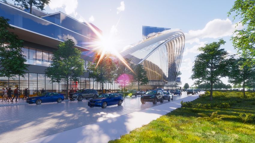
Contents
1. Executive Summary ..................................................................................................................................... 2
2. Background and Context ............................................................................................................................ 5
   2.1 Travel Behavior in the Study Area.......................................................................................................... 5
     2.1.a Regional Travel Demand to San Diego International Airport............................................................ 6
     2.1.b Existing Transportation Mode Share to San Diego International Airport .......................................... 6
     2.1.c Transit Access to San Diego International Airport ............................................................................ 8
     2.1.d Key Airport Access Roadways ......................................................................................................... 8
     2.1.e Projected Growth and Travel Conditions ...................................................................................... 13
   2.2 Regional Agency Development Proposals ............................................................................................ 15
     2.2.a Airport Authority Proposed Airport Development Plan .................................................................. 15
     2.2.b Port of San Diego Proposed Master Plan ...................................................................................... 16
     2.2.c City of San Diego Downtown Mobility Plan .................................................................................. 16
     2.2.d Navy Region Southwest Old Town Campus .................................................................................. 16
     2.2.e San Diego Metropolitan Transit System ........................................................................................ 17
     2.2.f Caltrans District 11........................................................................................................................ 17
     2.2.g SANDAG ...................................................................................................................................... 17
   2.3 SANDAG Airport Connectivity Subcommittee ..................................................................................... 17
3. Airport Connectivity Subcommittee Goals and Objectives ......................................................................... 18
4. Airport Connection Concepts ................................................................................................................... 19
   4.1 Identification and Screening of Early Concepts .................................................................................... 19
   4.2 San Diego International Airport Connector Concepts .......................................................................... 21
5. Evaluation Criteria .................................................................................................................................... 32
   5.1 Passenger Convenience and Ridership................................................................................................. 33
     5.1.a Improved Access to Transit ........................................................................................................... 33
     5.1.b Passenger Convenience ................................................................................................................ 34
     5.1.c Transit Ridership ........................................................................................................................... 40
   5.2 Reduce Congestion Related to the San Diego International Airport Access .......................................... 43
     5.2.a Transit Mode Share ...................................................................................................................... 43
     5.2.b Congestion Reduction Around San Diego International Airport .................................................... 43
   5.3 Greenhouse Gas Emissions and Vehicle Miles Traveled ........................................................................ 47
   5.4 Feasibility ............................................................................................................................................ 47
     5.4.a Footprint Requirements and Space Constraints ............................................................................. 48
     5.4.b Transit Operations and Construction Risks .................................................................................... 49
     5.4.c Roadway and Freeway Operations ................................................................................................ 52
     5.4.d Geotechnical, Seismic Conditions, Hazardous Materials, and Soils ................................................ 53
     5.4.e FAA and Navy Requirements, Protected Species, and Regulatory Agency Considerations .............. 55
     5.4.f Utility Conflicts.............................................................................................................................. 57
   5.5 Cost .................................................................................................................................................... 57
   5.6 Economic Benefit ................................................................................................................................ 59
6. Summary of Key Findings ......................................................................................................................... 62
7. Recommendations and Next Steps ............................................................................................................ 63
8. Appendices .............................................................................................................................................. 63
1. Executive Summary
Many world-class cities have transportation systems that provide seamless, direct, and quality transit
connections between their airports and their downtown metropolitan areas. These systems provide quick,
convenient options to access the airport using mass transit. The systems could connect directly to multimodal
hubs that supply passenger amenities such as baggage handling services, airport information and display
boards, remote ticketing services, and even airport security should those facilities be available. For example,
from John F. Kennedy International Airport, a passenger can easily take the AirTrain JFK elevated people
mover to connect to the New York City subway system. Newark Liberty International Airport is connected
directly to an AirTrain Newark monorail, which connects to the regional rail system. From the
Miami International Airport, travelers can access the Metrorail Orange Line and connect to the Tri-Rail System
at an airport intermodal facility. From the world’s busiest airport in Atlanta, Georgia – Hartsfield-Jackson
Atlanta International Airport travelers can access the Atlanta subway system and the Metro Atlanta Rapid
Transit Authority. Such transit connections can also be found at Minneapolis – Saint Paul International
Airport, Chicago’s O’Hare International Airport, and Denver International Airport. Both San Francisco
International Airport and Oakland International Airport connect directly to the Bay Area Rapid Transit. Finally,
Los Angeles World Airports anticipates the completion of an automated people mover (APM) to connect
Los Angeles International Airport to the LA Metro regional rail system by 2023.
As the San Diego County Regional Airport Authority (Airport Authority) is planning to modernize San Diego
International Airport’s Terminal 1, now is the time for the San Diego region to seize the opportunity to
modernize the transportation system with a direct transit connection to its airport.
San Diego International Airport is the busiest single-runway airport in the nation and has established itself as
a major economic engine for the region. The airport is preparing for the modernization of its facilities to
accommodate an anticipated increase of 16 million annual passengers by 2050, which will total an estimated
40 million passengers annually. Improving connectivity to the airport has been one of the region’s biggest
challenges throughout the past several decades. The Airport Authority is poised to join the ranks of other
forward-looking airports that offer passengers and visitors cleaner, environmentally-friendly ways to avoid
traffic and connect to the regional transit system.
Today, the San Diego Association of Governments (SANDAG) is advancing the region’s airport connectivity
plans following months of collaboration with regional partners. SANDAG has long served as the forum for
regional decision-making and is governed by a Board of Directors composed of mayors, councilmembers, and
county supervisors from each of the region’s 19 local governments. SANDAG works to build consensus;
develop strategic transportation plans; obtain and allocate resources; plan, design, engineer, and construct
public transportation; and provide information on a broad range of topics pertinent to the region’s quality of
life. As a key component of its regional transportation plans over the last decade, SANDAG has identified
concepts for airport connectivity at an Intermodal Transportation Center (ITC) located near the airport.
For several decades, local agencies have worked diligently—but often in a siloed or segmented way—to
develop their own potential improvement plans. Without a regional effort, a comprehensive plan to connect
the San Diego International Airport to the region’s rail transit system has not been achieved.

                                        Airport Connectivity Analysis | 2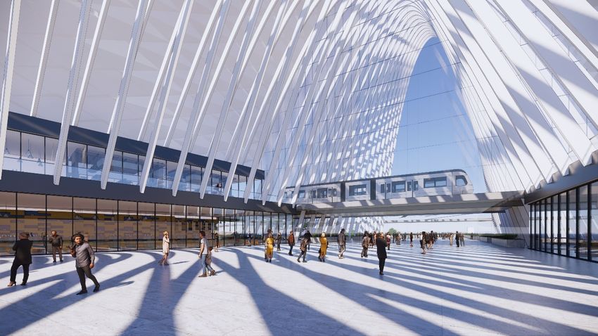
Last year, San Diego Mayor Kevin Faulconer gathered the leaders of the Metropolitan Transit System (MTS),
Port of San Diego, Airport Authority, and Caltrans to challenge them to solve the airport connectivity problem
once and for all. Mayor Faulconer, stressing the urgency of this problem, asked SANDAG to lead the effort.
SANDAG Chairman Steve Vaus established the Airport Connectivity Subcommittee shortly thereafter.
Over the last nine months, SANDAG led a collaborative process with planners, engineers, data modelers,
legal, government relations, and communication staffers from SANDAG, City of San Diego, County of
San Diego, MTS, North County Transit District (NCTD), Port of San Diego, Airport Authority, and Caltrans
District 11. The inter-agency teams discussed multiple scenarios, briefed agency leaders, conducted research,
modeled transportation options, and presented findings to the Airport Connectivity Subcommittee, which
resulted in the four concepts that are presented in this Airport Connectivity Analysis.
Through SANDAG’s leadership, the effort has advanced, and the region has earned an unprecedented
commitment from local agencies to work together to develop a world-class transportation connection to
San Diego International Airport. On July 2, 2019, the Airport Authority announced it is preserving land for a
future transit connection at San Diego International Airport. In addition, the Airport Authority announced
that through its efforts, the airlines have agreed to allow the Airport Authority to spend over $500 million to
improve airport connectivity. The Airport Authority also pledged it will work with the Federal Aviation
Administration (FAA) to obtain authorization to use these funds for both on and off-airport transportation
improvements.
The Airport Connectivity Subcommittee has identified feasible concepts for a transit connection to the
San Diego International Airport.
•   Concepts 1 and 2 feature a Central Mobility Hub at Naval Information Warfare Systems Command
    (NAVWAR), which includes a multimodal transportation center with Amtrak and COASTER services,
    regional transit lines, and a high-frequency APM service. Concept 1 assumes a nonstop, high-speed APM
    service to San Diego International Airport via a one-mile-long tunnel route. Concept 2 assumes a
    high-speed APM service via a 3.6-mile-long surface level and elevated route along Pacific Highway,
    Laurel Street, and Harbor Drive with intermediate stops at the consolidated Rental Car Center and a
    future planned Port of San Diego development at Harbor Island East Basin.
•   Concept 3 includes a Central Mobility Hub, which has a multimodal transportation center with
    connections to regional transit lines. Amtrak and COASTER operators have indicated reluctance to stop at
    the Concept 3 Central Mobility Hub given its proximity to Old Town Transit Center and Santa Fe Depot,
    which warrants further discussion and service planning. This Central Mobility Hub would include a
    high-frequency APM service and an airport-like curb experience for auto-based travelers. The APM would
    provide service to San Diego International Airport via a 2.6-mile-long surface level and elevated route
    along Pacific Highway, Laurel Street, and Harbor Drive, with intermediate stops at the consolidated
    Rental Car Center and planned Port of San Diego development at Harbor Island East Basin.
•   Concepts 4a and 4b include an extension of the Trolley system to the planned San Diego International
    Airport transit station with an intermediate stop at the planned Port of San Diego development at
    Harbor Island East Basin.

                                       Airport Connectivity Analysis | 3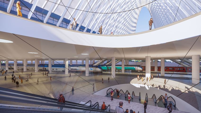
The report is structured to describe the airport transit connection Concepts 1 through 4 in greater detail, as
well as the goals and evaluation criteria agreed to by the Airport Connectivity Subcommittee, and the initial
analysis and findings. While the preliminary analysis demonstrates that all proposed concepts would achieve
the defined goals, the concepts vary in terms of performance, benefits, and risks. SANDAG has outlined the
pros, cons, risks, and rewards associated with Concepts 1 through 4, and recognizes that additional public
outreach should be conducted. Additional modeling, engineering analysis, concept development, and cost
estimating are still required to help decision makers select the best concept for the San Diego region.
Nevertheless, what is clear is that doing nothing is not an option. It is time to establish a robust airport transit
connection to address anticipated growth and congestion, meet environmental mandates, and address the
mobility needs of airport travelers for generations to come.
Initial analysis demonstrates that all concepts require complementary roadway improvements to key airport
access roadways. Early analysis also shows that a Central Mobility Hub at NAVWAR has the greatest potential
to provide increased transit access in the region and renders the greatest potential ridership. The mobility hub
at NAVWAR can be designed to accommodate sufficient space for convenient pick-up and drop-off facilities
and has the greatest potential to divert a significant amount of traffic away from key airport access roadways
with complementary traffic management policies. Additionally, whether in a tunnel, elevated, or at-grade, a
high-frequency APM appears to be a leading technology solution to connect people within and between
airport facilities and the regional rail system. APM systems can be found in 46 airports around the world.
They have the greatest ability to match passenger demand with greater efficiency and state-of-the-art
technology. APM systems operate without drivers or station attendants, typically travel on guideways on
narrower spans than traditional rail services. They use smaller vehicles, each capable of carrying standing
passengers while also providing airport passenger amenities, such as level boarding, wide doors, and space
for luggage. They also operate at high frequencies that allow passengers to arrive at their aircraft gates faster
and with less stress. A Trolley connection to the airport also has potential to provide improved transit
connectivity and is feasible to design and engineer. The Trolley system is familiar to regional travelers, yet
frequency of service, passenger convenience, and curb space at existing stations may be limited.
This report details how Concepts 1 through 4 initially range in terms of passenger convenience and user
experience, ridership, and ability to provide increased transit access, travel time to and from San Diego
International Airport, and how congestion around the airport can be reduced. The report details how vehicle
miles traveled (VMT) and greenhouse gas (GHG) emissions could be reduced through Concepts 1 through 4,
and explores feasibility, cost, and secondary economic benefits for each concept. The evaluation of the
analyzed airport connectivity concepts is shown in Figure 6-1 at the end of this report.
SANDAG and stakeholder partners are committed to continuing to work together to improve transit access to
the San Diego International Airport and develop a world-class transportation system that enhances the
passenger experience and addresses anticipated severe congestion on key airport access roads. This report
outlines the next steps to providing the Board and other key decision makers with more refined analysis on
project concepts so that a locally preferred alternative can be selected to move forward into the
environmental review phase. SANDAG will work with all agency partners to coordinate and provide feedback
on technical analyses and policy assumptions that involve airport connectivity and other’s planning
jurisdictions.

                                         Airport Connectivity Analysis | 4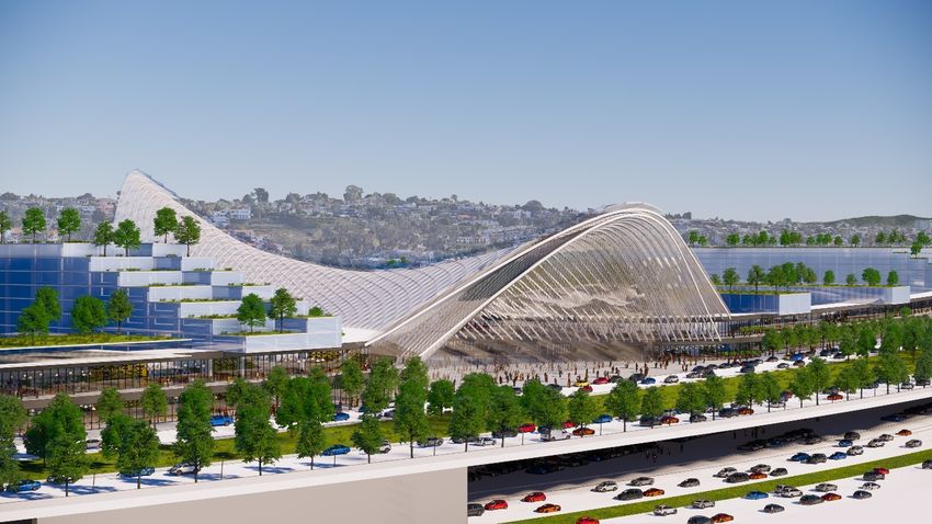
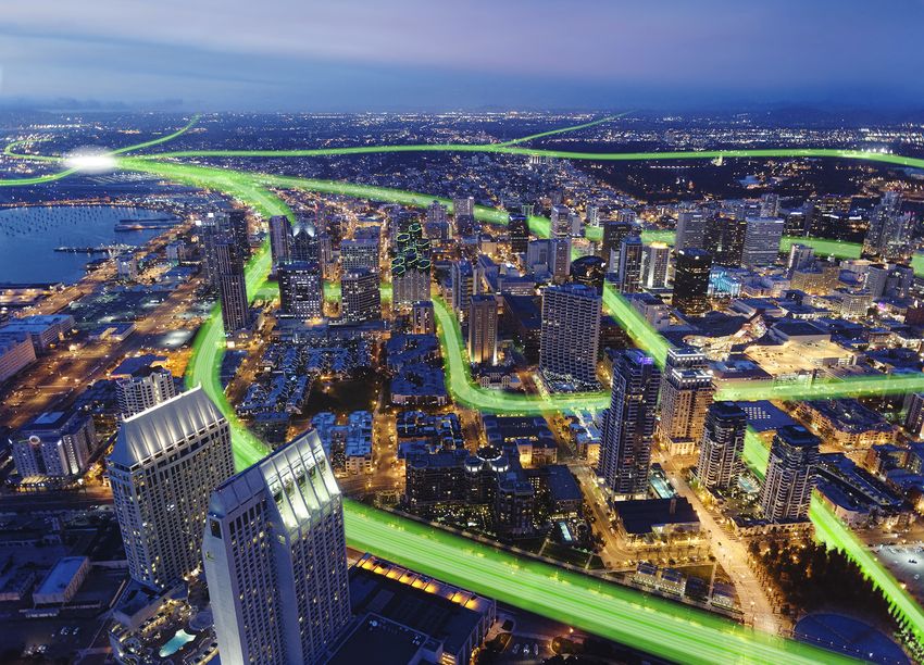
2. Background and Context
2.1 Travel Behavior in the                 Figure 2-1: Study Area Location
Study Area
To help identify airport connector
project options, SANDAG assessed
overall project concept benefits
based on both a macro and micro
level, looking at both the regional
context and the near-airport
transportation system. This section is
intended to describe the existing
airport area context, transportation
network, current roadway and
freeway access routes, existing mode
share, and provide an overview of
other key considerations about travel
behavior to and from San Diego
International Airport.
The study area is located in the
central portion of the region as
shown in Figure 2-1. The study area
itself is generally bound by I-8, I-5,
Downtown San Diego, and
San Diego Bay, as shown in
Figure 2-2.

                                         Airport Connectivity Analysis | 5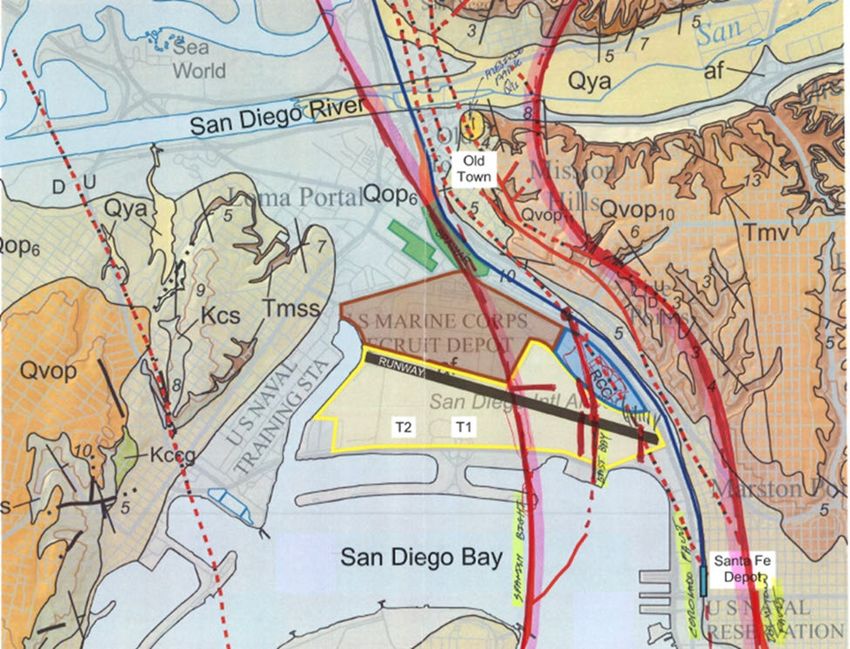
Figure 2-2: Project Study Area

2.1.a Regional Travel Demand to San Diego International Airport

The San Diego region contains seven sub-regional areas, known as metropolitan statistical areas. Figure 2-3
shows these areas and the portion of regional trips to the San Diego International Airport that they represent.
2.1.b Existing Transportation Mode Share to San Diego International Airport
Today, the vast majority of trips to the San Diego International Airport (approximately 99%) occur via private
auto-based modes that use the freeway and roadway system, similar to what is observed throughout the
San Diego Region.
Table 2-1 shows the primary transportation modes used to access San Diego International Airport.

                                       Airport Connectivity Analysis | 6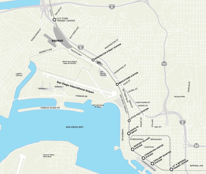
Figure 2-3: Regional Trips to San Diego International Airport by Metropolitan Statistical Areas

                                   Airport Connectivity Analysis | 7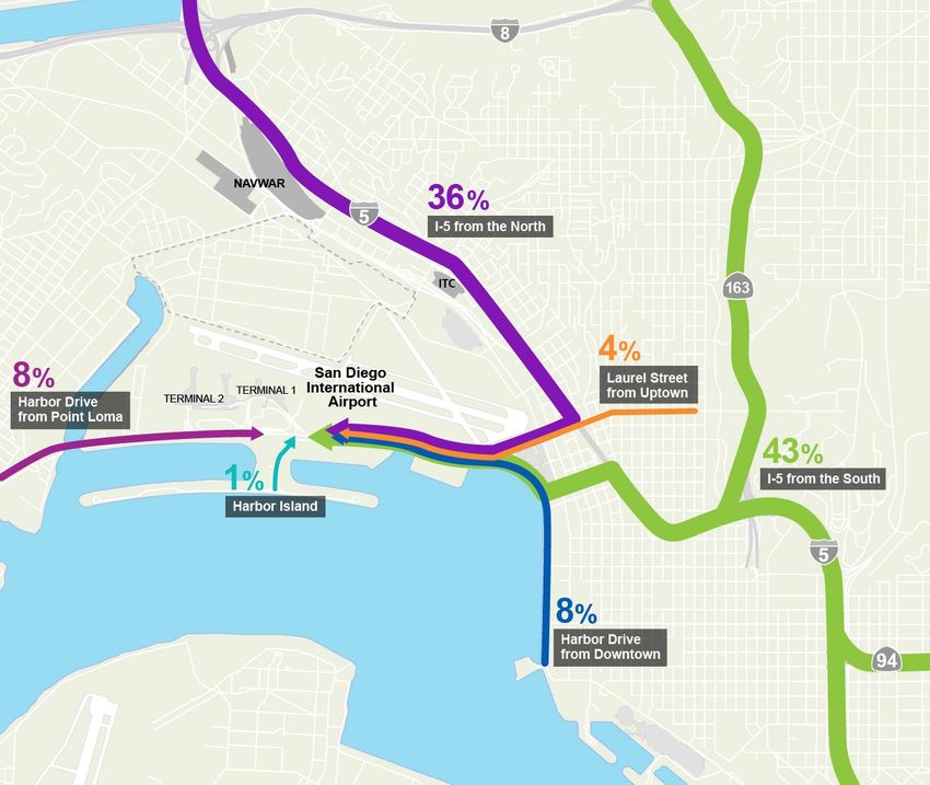
Table 2-1: Transportation Mode to San Diego International Airport, 2018

    Access Mode                            Mode Share                Access Mode            Total Mode Share

                                                                    All Private Auto
    Private Autos and Rental Cars               59%                                                 99%
                                                                         Modes

    Transportation Network
                                                32%
    Companies (TNCs) and Taxis

    Private Shuttles                            8%

    Transit                                     1%                       Transit                     1%

    Total Mode Share                           100%                                                100%

Source: Airport Authority

2.1.c Transit Access to San Diego International Airport
Current and planned transit services include:
•      Local Bus: MTS Route 992 operates between Downtown San Diego and San Diego International Airport
       via Broadway, Santa Fe Depot, and Harbor Drive.
•      Trolley (Light Rail): The MTS Green Line Trolley serves Middletown Station, which is a short but
       inconvenient walk to San Diego International Airport’s free on-airport bus serving the terminals and
       consolidated Rental Car Center. The pedestrian facilities are not easily navigated given the steep grades
       and narrow sidewalks. By 2022, the MTS Blue Line Trolley is also planned to run on the same corridor
       and serve the Middletown Station.
•      Future Shuttle from Old Town Transit Center: A new bus route connecting Old Town Transit Center
       to San Diego International Airport is currently under development by the Airport Authority in partnership
       with MTS. It is planned to open in 2020.
2.1.d Key Airport Access Roadways
Today, residents, airport employees, and visitors rely primarily on automobiles to reach the airport terminals.
There are limited access routes to and from the airport for auto-based traffic. Key airport access roadways
include:
•      Harbor Drive: An arterial roadway with three lanes in each direction that provides the only access route
       to the San Diego International Airport terminals. Harbor Drive connects to Downtown San Diego to the
       east and Point Loma to the west.
•      Hawthorn Street/Grape Street: These are one-way streets with three lanes in each direction that
       collect airport traffic to and from the south. Hawthorn and Grape streets connect to I-5 to the east and
       Harbor Drive to the west.
•      Kettner Boulevard/India Street: These are one-way streets with three lanes in each direction that
       collect airport traffic to and from the north. Kettner Boulevard/India Street connect to I-5 to the north
       and Laurel Street to the south.

                                          Airport Connectivity Analysis | 8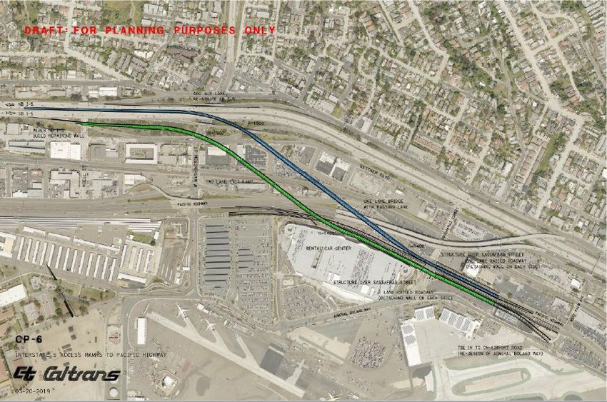
•   Laurel Street: An east-west roadway with two lanes in each direction that collects airport traffic from
    the north via the Kettner Boulevard/India Street couplet and collects local traffic from the east.
    Laurel Street connects to Uptown to the east and Harbor Drive to the west.
•   Pacific Highway: An arterial roadway with three lanes in each direction that provides connectivity
    between Downtown San Diego and neighborhoods to the north.
Additional details of the roadway and freeway system can be seen in Figure 2-2. As shown in Figure 2-4,
43% of traffic comes from the south via I-5. A total of 36% comes from the north via I-5. Local traffic makes
up the remaining 21%. As shown in Figure 2-4, a total of 83% of trips to San Diego International Airport use
the ten-lane (five inbound and five outbound lanes) system formed by Laurel Street, Hawthorn Street, and
Grape Street. Another 8% of the trips come from Downtown San Diego via Harbor Drive, resulting in a total
of 91% of all airport traffic converging at Harbor Drive near the U.S. Coast Guard Station as shown in
Figure 2-6.
Figure 2-4: Traffic Patterns to and from Airport

                                       Airport Connectivity Analysis | 9
Figure 2-5: I-15 Corridor Access to Airport
Airport Connectivity Analysis | 10While the majority of airport users reside north of the airport (see Figure 2-3) airport users along the I-15
corridor predominantly use the SR 163 connection to I-5 to access the airport. As shown in Figure 2-5, the
SR 163 connection to I-5 is the most direct route to and from the airport for those who live along the
I-15 corridor. This is why the highest percentage (43%) of traffic comes from the south via I-5.
Figure 2-6: Roadway Access to and from Airport
Note: Colored lines and arrows represent traffic flow.
Airport Connectivity Analysis | 11Given the relatively low current transit mode share, maintaining adequate roadway access to San Diego
International Airport remains an important objective. In addition to a focus on airport access, the City of
San Diego is working to reduce traffic in the Little Italy neighborhood by shifting airport traffic off the
Grape/Hawthorn streets couplet (Figure 2-6). The Airport Authority is working alongside SANDAG and other
partner agencies on long-term concepts to repurpose Laurel Street so it can serve as the airport’s priority
roadway between Pacific Highway and the airport (see Figure 2-7). This would be accomplished by providing
a three-lane entry road from Laurel Street parallel to Harbor Drive to and from the airport. The entry road
would be for airport use and Harbor Drive would serve all waterfront and other uses. It would focus airport
traffic onto Laurel Street and away from Harbor Drive freeing up roadway capacity on Harbor Drive for the
creation of a "the next great waterfront” as envisioned by the Port of San Diego, one concept of which is
shown in Figure 2-8. Shifting traffic away from Harbor Drive would allow for space to be repurposed for
pedestrian, bikeway, transit, and recreational uses for an improved waterfront experience. The challenge
becomes how to get traffic from the Pacific Highway and Laurel Street intersection to I-5 as efficiently as
possible. Developing an efficient roadway access plan in and around the airport is a complex challenge
considering the many varied goals.
Figure 2-7: Airport Priority Roadway
Note: Colored lines and arrows represent traffic flow on both Harbor Drive and the on-airport roadway.
Airport Connectivity Analysis | 12Figure 2-8: Harbor Drive Waterfront Vision
Source: Integrated Planning Port Master Plan Update, February 25, 2019, Port of San Diego
2.1.e Projected Growth and Travel Conditions
Growth in the region’s population and economy is projected to lead to major increases in travel demand at
San Diego International Airport, with over 67% more passengers expected in 2050 than in 2018
(see Table 2-2). Without alternative options to reach the airport, the vast majority of passengers will continue
to use auto-based modes, leading to heavy congestion on key airport access roadways. This level of traffic
would overwhelm the roadway system at peak times, causing major congestion and delays. With the
expected traffic increases and without alternative options to reach the airport, key airport access roadways
would begin to experience gridlock conditions. This would result in significant delays during peak hours when
most air travelers need to reach their flights.
Table 2-2: Existing and Projected Travel Demand at San Diego International Airport
Annual Passengers Daily Traffic on Harbor Drive
2018 24 million 95,000
132,000
2050 40 million
(No Build Scenario)
Growth, 2018–2050 67% 39%
Sources: SAN Air Traffic Reports, SAN Airport Development Plan Draft EIR, SANDAG Series 13 Regional Travel Model 2.2 Past
Studies to Address Airport Access
Airport Connectivity Analysis | 13San Diego has long desired to improve overall access to San Diego International Airport, to improve transit
mode share, and connect the airport to the regional rail system. Yet, some key challenges must be addressed
before these goals can be reached. First, MTS Bus Route 992, which is the main bus service to the airport’s
two terminals, is currently a local route that lacks any priority measures. Moreover, there is no direct
pedestrian connection between an on-airport Rental Car Center shuttle and the MTS Middletown Trolley
Station that stops a few hundred feet away. The sidewalks connecting the MTS Trolley station and Rental Car
Center are not currently Americans with Disabilities Act accessible, have a significant grade change, and can
be confusing for pedestrians even with wayfinding signage. Further, the existing transit options do not
operate during all airport employee shifts to adequately support the airport employee population.
Given that multiple transit corridors are in proximity and can feasibly connect to San Diego International
Airport, numerous planning studies regarding appropriate ground access projects have been initiated by
various agencies, including the Airport Authority, Port of San Diego, Caltrans District 11, SANDAG, and the
City of San Diego. Since 1982, these studies have been conducted in an effort to improve access conditions
and transit connectivity at the airport:
• North Harbor Drive Multimodal Study (2018)
• Downtown to Airport Skyway Feasibility Study (2018)
• Airport Development Plan Draft EIR (2018)
• Uptown Community Plan (2016)
• Downtown San Diego Mobility Plan (2016)
• San Diego International Airport Transit Plan (2016)
• I-5 Ramps SANDAG (2016)
• San Diego Forward: The Regional Plan (2015)
• Mid-Coast Corridor Transportation Impacts and Mitigation Report (2014)
• City of San Diego Traffic Signal Communications Master Plan (2014)
• San Diego Airport Multimodal Accessibility Plan (AMAP) (2012)
• Airport Intermodal Transit Center Study Phase 1 Final Report (2010)
• Destination Lindbergh (2009)
• Airport Master Plan (2008)
• Central Interstate 5 Corridor Study (2003)
• Point Loma / Airport Trolley Extension Study (1982)
While many of these studies have focused on each individual agency’s jurisdiction and have provided
recommendations for segments of critical transportation corridors servicing San Diego International Airport,
collectively they have not presented a fully integrated transit airport access strategy for the region.
Moreover, among many reasons, these recommendations have not advanced due to lack of a shared vision
by stakeholders, a lack of funding, and a lack of available right-of-way.
Airport Connectivity Analysis | 142.2 Regional Agency Development Proposals
2.2.a Airport Authority Proposed Airport Development Plan
Since 1928, the San Diego International Airport has served the region’s commercial air travel and has grown
into a major international airport now serving 22 million passengers each year. San Diego International
Airport has established itself as a major regional economic engine and is the busiest single-runway airport in
the nation. Notwithstanding past failed efforts to relocate, the airport has successfully accommodated the
region’s commercial air travel and has made significant investment to modernize and maximize airport
facilities.
In 2018, the Airport Authority released the Airport Development Plan (ADP) defining the master plan for
San Diego International Airport, as part of the continued commitment to deliver world-class passenger
experience and to meet existing and anticipated future passenger activity. Future forecasts project that the
airport’s passenger activity will increase to 40 million annually by 2050. Now, the Airport Authority is
preparing an Environmental Impact Report (EIR) pursuant to the California Environmental Quality Act to
modernize Terminal 1 by 2026. The Airport Authority also proposes to develop a new on-airport entry
roadway from westbound Laurel Street and North Harbor Drive for vehicles coming to the airport from the
east in addition to developing a new multi-use bicycle and pedestrian path along the north side of
North Harbor Drive to reduce traffic on North Harbor Drive. Buses to and from the airport Rental Car Center
would be removed from Harbor Drive and routed exclusively through the new on-airport entry and link road.
Separate arriving and departing passenger traffic, with an elevated departures roadway and curbside check-in
would be expanded. Parking immediately adjacent to the redeveloped Terminal 1 would be expanded.
Airfield improvements would include realignment of Taxiway B and a new Taxiway A to allow more efficient
flow for aircraft taxiing operations.
As part of the ADP, the Airport Authority has announced a landmark pact on its transportation infrastructure
investment. On July 2, 2019, the Airport Authority announced it reached a new ten-year agreement with its
airline partners for a major investment in transportation infrastructure to help alleviate traffic congestion and
improve access to the San Diego International Airport. This agreement outlines $350 million for on- and
potentially off-airport transportation infrastructure. These funds could potentially be used for an on-airport
transit station and a transit connection to the existing regional transit system. The agreement also outlines an
additional $165 million for on- and off-airport access improvement plans, including an on-airport entry road
connecting from Laurel Street and Harbor Drive and the construction of a bicycle path. Additionally, the
airport is preserving right-of-way for a multimodal mobility corridor to serve Rapid Bus, Trolley, or an APM
system that can also potentially serve Harbor Island redevelopment projects being considered by the Port of
San Diego.
The agreement enables partnership with other regional agencies to improve access to the airport through
transportation and transit projects.
Airport Connectivity Analysis | 152.2.b Port of San Diego Proposed Master Plan
For the past few years, the Port of San Diego has prepared a comprehensive integrated planning initiative to
update their Port Master Plan, which is similar to a general plan for a city or county. The effort spans
6,000 acres of water and land on and around San Diego Bay in the cities of San Diego, National City,
Chula Vista, Imperial Beach, and Coronado. As a blueprint for development, it is intended to create certainty
for developers and community members by codifying a vision for how future projects will fulfill public goals.
In the summer of 2019, the Port of San Diego released a discussion draft of the updated Port Master Plan for
public review. In order to create the “next great waterfront,” it is anticipated that the updated Port Master
Plan will result in additional development and changes to the roadway system. Harbor Drive is a key element
of the “next great waterfront” vision. Both the Airport Authority and the Port of San Diego are working in
collaboration to deliver access and circulation plans that are complementary and preserve the opportunity for
future transit connections to the airport.
2.2.c City of San Diego Downtown Mobility Plan
In 2016, the City of San Diego adopted their Downtown Mobility Plan. The Downtown Mobility Plan
emphasizes the development of active transportation networks and the improvement of the walking and
biking environments, as these modes are not as advanced as transit and auto networks in terms of safe,
quality facilities. The Downtown Mobility Plan provides for an integrated transportation network of
greenways, sidewalks, bikeways, transit services, roadways, and freeways that provides for the safety of all
travelers – including the elderly, youth, and disabled – both within Downtown and to surrounding
communities. It is designed to encourage a transportation network that provides convenient access to
valuable community resources such as employment centers, parks and the waterfront, cultural and
entertainment attractions, and civic uses. It is a transportation network that supports community health and
well-being, promotes a strong economy, and builds social capital.
2.2.d Navy Region Southwest Old Town Campus
Navy Region Southwest is dedicated to creating a more modern and efficient workspace on the Naval Base
Point Loma Old Town Campus (OTC) to better meet the mission requirements of NAVWAR. Navy Region
Southwest and NAVWAR desire to create modern facilities for the 5,000 engineers, scientists, and staff
located at OTC. The 72-acre OTC site is located at I-5 and Old Town Avenue, a short distance from San Diego
International Airport. On July 10, 2019, SANDAG and Navy Region Southwest signed a Memorandum of
Understanding (MOU) enabling a collaborative process to explore concepts for the revitalization of the OTC
property, including the possibility of a Central Mobility Hub with a direct connection to the airport. While the
MOU does not commit either to a course of action, the agreement allows for collaboration and begins the
planning process so both SANDAG and the Navy can work together with the community and stakeholder
agencies to evaluate concepts.
Airport Connectivity Analysis | 162.2.e San Diego Metropolitan Transit System
Several of the previous studies which identified transportation connection improvements in and around the
airport had recommended MTS Route 992 to the airport be converted into a high frequency, limited stop,
bus Rapid service. In spring 2019, MTS kicked off Elevate SD 2020, an effort to develop new mobility
solutions by engaging the community to help identify projects and priorities that can shape a potential
funding measure being considered by the MTS Board of Directors for 2020. The Elevate SD 2020 values
include providing better access to employment and educational opportunities, improving access for seniors
and people with disabilities, and seeking out opportunities for long term high-investment infrastructure
improvements. In early spring 2019, MTS released results of a poll in which more than two thirds of
respondents identified a transit connection to the airport as a high priority for a potential funding measure to
address. MTS has since studied concepts to extend the Trolley to San Diego International Airport and has
collaborated with SANDAG to include their concepts and preliminary analysis in this report.
2.2.f Caltrans District 11
In 2016, Caltrans District 11 and SANDAG collaborated on a project study report evaluating connections via
I-5 connector ramps to provide direct and convenient access to regional activity centers such as the San Diego
International Airport. While such studies have not yet progressed beyond the initial concepts, Caltrans has
worked in coordination with SANDAG, Airport Authority, Port of San Diego, and City of San Diego to
continue to explore and develop feasible freeway access improvements that serve the airport and the region
at large.
2.2.g SANDAG
On February 22, 2019, the Board approved an action plan to develop a bold new vision for San Diego
Forward: The 2021 Regional Plan (2021 Regional Plan). The action plan seeks to transform the way people
and goods move throughout the San Diego region by providing compelling alternatives to driving. This
innovative plan for a transportation system strives to get people where they need to go quickly, meet or
exceed state climate goals, and support local jurisdictions’ achievements of climate action plan goals using
proven and developing technologies. This new vision for the future will build on the significant public input
received so far, as well as ensure social equity, sustainability, supporting land use and housing, and economic
opportunities. Completion of the 2021 Regional Plan is anticipated in late 2021. As part of the 2021 Regional
Plan, SANDAG plans to include transit connections to San Diego International Airport as outlined in this
Airport Connectivity Analysis.
2.3 SANDAG Airport Connectivity Subcommittee
On December 21, 2018, the Board approved the draft charter and membership for the Airport Connectivity
Subcommittee, a temporary subcommittee, advisory in nature, to identify future transportation solutions for
improved transit and road connectivity to the San Diego International Airport. The purpose of the Airport
Connectivity Subcommittee is to lead discussions and explore options for how best to build consensus around
transportation solutions for improved connectivity to the airport for generations to come.
The work of the Airport Connectivity Subcommittee will conclude upon adoption of a preferred
transportation solution by the Board. SANDAG Chair and Poway Mayor Steve Vaus serves as the Chair of the
Airport Connectivity Subcommittee. Members of the subcommittee were appointed by the Chair and include
Board members from the following organizations: SANDAG, City of San Diego, County of San Diego, MTS,
NCTD, Port of San Diego, Airport Authority, and Caltrans District 11.
Airport Connectivity Analysis | 17At its first meeting on January 3, 2019, the Subcommittee reviewed the schedules for the development of the
2021 Regional Plan, Airport Development Plan Environmental Impact Report, and Port Master Plan update.
The subcommittee also discussed the need for interagency collaboration, reviewed airport connectivity studies
completed to date, and discussed innovative solutions for improving airport connectivity. To provide technical
input, an interagency project team was formed compromising agency staff and consultant experts in planning,
engineering, transportation modeling, finance, government relations, communications, and law. The Board
allocated $1 million toward the expenses related to the study of concepts.
3. Airport Connectivity Subcommittee Goals and Objectives
The Board set the primary goal for the Airport Connectivity Subcommittee to identify future transportation
solutions for improved transit and roadway connectivity to the airport. Based on the Board’s definition of
success, the following objectives were identified:
1. Create a Central Mobility Hub with regional connections to the airport. The Central Mobility Hub
should bring multiple modes of transportation to a central location where, with one transfer, intercity
rail, commuter rail, Trolley, bus, and micro-mobility can connect to the airport. The Central Mobility Hub
should have the ability to accommodate future mobility shifts for generations to come.
2. New direct transit connection to and from the airport. San Diego International Airport should join
other airports in the country that have a direct and efficient transit connection to their regional rail and
transit systems.
3. More direct, convenient access for auto traffic to and from the airport. A roadway modification
plan should be developed to avoid future gridlock on key airport access roadways and accommodate
safer, more complete streets inclusive of pedestrian and bike facilities.
4. Improving Laurel Street to serve as a primary access roadway. A roadway modification plan should
be developed to convert Laurel Street into the airport priority roadway. Given the space limitations, it is
critical to identify ways to enhance Laurel Street to address congestion, improve the overall roadway
network, and enhance the passenger experience.
5. Harbor Drive to be converted into the next great waterfront street with dedicated transit
lanes. A roadway modification plan should be developed to reduce traffic on Harbor Drive so space
along Harbor Drive can be converted to waterfront uses. Plans include dedicated transit lanes, enhanced
pedestrian and bicycle facilities, and improved curb amenities.
6. Reduce airport traffic on Grape and Hawthorn streets. Grape and Hawthorn are two local
constrained streets in the City of San Diego’s Little Italy neighborhood that experience heavy traffic
volumes, mostly due to airport traffic. To implement the City of San Diego’s Downtown Mobility Plan
elements, traffic on Grape and Hawthorn streets should be reduced to enable safer, more pedestrian-
and bicycle-friendly amenities.
7. Maintain Pacific Highway for local auto traffic and active transportation solutions. As a local
roadway, included in the City of San Diego’s Downtown Mobility Plan, Pacific Highway should include
enhanced bicycle and pedestrian improvements.
The Airport Connectivity Analysis also should advance regional goals of reducing environmentally harmful
emissions, increasing social equity, encouraging community engagement, and promoting economic
development opportunities in the San Diego region.
Airport Connectivity Analysis | 184. Airport Connection Concepts
4.1 Identification and Screening of Early Concepts
On January 18, 2019, and on February 8, 2019, SANDAG issued Requests for Information to garner ideas
from the marketplace for improved airport connectivity and ideas for a Central Mobility Hub. SANDAG
received many ideas for APM systems, transportation systems management, demand management
technologies, pricing strategies, operating systems, vehicle technologies, roadway and freeway modifications,
land use, and Central Mobility Hub concepts.
SANDAG, with help from the interagency working group, evaluated this wide range of technologies and early
concepts, seeking the best solutions for improved airport connectivity. The technologies and early concepts
for improving airport connectivity can be categorized into four main areas:
• APM or similar technologies
• Transportation Systems Management and Transportation Demand Management (TSM/TDM) and related
technologies
• Central Mobility Hub and land use solutions
• Roadway, freeway, and transit routing options
APM technologies are similar to manually operated technologies, like the Trolley, except that they operate
with an automated train control system. APM systems are centrally controlled with no in-vehicle drivers.
For day-to-day operations, the APM systems can operate at shorter (more frequent) headways and can travel
on steeper and narrower guideways than manually operated systems. For the purposes of this study, APM on
fixed-guideway (track) with level-floor vehicles are assumed. These types of APM systems are used at many
airports throughout the country and world. A Trolley connection to the airport was also evaluated.
Numerous TSM/TDM solutions and related technologies were evaluated including: information network
architecture solutions, fleet monitoring and management technologies, data analytics solutions, train control
systems, advanced transportation demand management technologies, dynamic pricing and tolling
technologies, incentive-based mobile applications, traffic signal control and management systems, parking-
management technologies, curb-management technologies, pedestrian safety technologies, and integrated
payment systems. An Airport Connectivity Think Tank Workshop was held on March 6, 2019, focusing on the
application of TSM/TDM and related technologies for improved airport connectivity. Assuming limitations for
an expanded freeway and roadway network and the possibility of a Central Mobility Hub to provide an
auxiliary location for passenger pick-up and drop-off, for the purpose of this study, future strategies to relieve
congestion on key airport roads associated with airport-related traffic will be carried forth for further study.
Several Central Mobility Hub and land use concepts were evaluated including relocating the airport terminals
from the south side of the airport to the north side to provide greater proximity to existing transit, roadway, and
freeway infrastructure. The Airport Authority previously analyzed this concept and determined there is
insufficient space on the north side of the airport to accommodate the terminals and critical airport operational
infrastructure. Concepts for locating a Central Mobility Hub at the Old Town Transit Center or Santa Fe Depot
have been screened out as there is insufficient space to accommodate Central Mobility Hub requirements at
these locations. There is limited ability to expand the Old Town Transit Center as it is surrounded by state park
lands and roadway infrastructure including overhead I-5 bridge structures. Santa Fe Depot is surrounded by high
density land uses including residential high-rise towers. Concepts for repurposing land use from NAVWAR to
Laurel Street and across tidelands are beyond the scope of this study. The two most promising sites for the
location of a Central Mobility Hub are at the NAVWAR and ITC locations.
Airport Connectivity Analysis | 19Numerous ideas for roadway and freeway modifications were considered. These ideas included
undergrounding I-5 and reconstructing the I-5/I-8/Pacific Highway freeway and roadway system. These are
considered too costly and impactful to the surrounding community. The concept of connecting
Pacific Highway to I-5 to and from the north, shown in Figure 4-1, was determined to be costly, require large
amounts of private property acquisition, and potentially create high levels of congestion on local streets,
especially at the Pacific Highway and Laurel Street intersection. This concept also would have limited utility
and it would only serve traffic to and from the north, while the majority of airport traffic comes to and from
the south, as discussed in Section 2.1.d.
Figure 4-1: Freeway Connectors from Pacific Highway to I-5
Another suggestion was to create a shallow tunnel system of roadways to and from the airport for improved
connectivity. This concept was not carried forward due to cost, impacts to the community, and design and
construction challenges. It would be expensive and challenging to construct in the soils made up of bay fill in
and around the airport from the surface level to roughly 40 feet deep (see Figure 4-2). Nevertheless, the
concept for a deep tunnel to connect the Central Mobility Hub to the airport was carried forward based on
preliminary analysis as soil conditions are more favorable below 40 feet deep.
Airport Connectivity Analysis | 20Other suggestions for an APM
connection around the west side Figure 4-2: Soil Characteristics In and Around San Diego
of the airport to connect International Airport
Point Loma/Liberty Station
communities to the airport were
not carried forward due to the
expected low ridership potential
due to the lower land use
intensities in these areas. An
APM connection around the east
side of the airport would capture
passengers from the Rental Car
Center and the future planned
development at Harbor Island East Basin and is seen as more viable and cost-effective solution and does not
prohibit the possibility of future extension around the west side of the airport.
Suggestions for connecting to the existing Trolley system were narrowed to two locations: the existing Trolley
bridge over Laurel Street and connecting at the trench under Grape and Hawthorn streets.
4.2 San Diego International Airport Connector Concepts
Working collaboratively with the Airport Connectivity Subcommittee, the interagency working group, and
subject matter experts, four concepts were defined to achieve the following:
• Improve transit access to and from the airport
• Minimize travel time to and from the airport
• Reduce congestion related to airport access
• Reduce GHG emissions and VMT
• To be feasible, constructible, and cost effective
• Improve transit user experience and convenience
Over several months, these concepts and corresponding assumptions were developed and refined by
SANDAG with input from the various agencies. In order to achieve the objectives of reducing traffic in
Little Italy and to reduce traffic on Harbor Drive so Harbor Drive can be repurposed for waterfront uses, the
following roadway and freeway elements common to each concept include:
• Convert Laurel Street to an airport-priority roadway between Pacific Highway and the airport as
envisioned in the Airport Development Plan to remove airport traffic from Harbor Drive (see Figure 2-7).
• Repurpose Harbor Drive from six lanes to four lanes with dedicated transit lanes and bikeway lanes from
Harbor Island Drive to the Convention Center in support of the Port Master Plan Update and waterfront
vision (Figure 2-8).
• Widen Laurel Street between Pacific Highway and I-5, providing the most direct route from the airport-
priority roadway to I-5.
• Construct new I-5 freeway ramp connections to Laurel Street, supporting a direct connection from I-5 to
Laurel Street and the airport-priority roadway.
• Remove I-5 freeway ramp connections to Grape and Hawthorn streets to reduce traffic in Little Italy.
Airport Connectivity Analysis | 21In addition to the common roadway and freeway elements for the concepts, the following redevelopment
assumptions for the NAVWAR site were included:
• Approximately 3,500 residential units
• 250 hotel rooms
• 300,000 square feet of community-serving commercial
• 1.7 million square feet of office to accommodate Navy uses
Additionally, Concept 3 assumes redevelopment of the ITC site with approximately 1,400 residential units,
330 hotel rooms, and 460,000 square feet of office uses.
Concept 1 – Central Mobility Hub at NAVWAR with Tunnel APM Connection to Airport
Figure 4-3: Concept 1
Concept 1 features the Central Mobility Hub at NAVWAR, which would be a multimodal transportation
center with high-frequency APM service to the airport, numerous connections to regional transit lines, and an
airport-like curb experience for auto-based travelers (see Figures 4-4 and 4-5). The 72-acre NAVWAR site is
located between Pacific Highway and I-5, just south of the Old Town Transit Center.
Airport Connectivity Analysis | 22A central station “Great Room” with views of San Diego Bay would be the centerpiece of the
Central Mobility Hub, see Figures 4-6 and 4-7. Transportation functions would be spread across multiple
levels. Multi-level roadways—like those at the San Diego International Airport’s Terminal 2 and other major
airports—would separate arrivals and departures (Figures 4-8 and 4-9). Auto access would be available from
Pacific Highway or via a new direct access ramp (DAR) on I-5. A new I-5 interchange at Hortensia Street
would replace the existing Old Town Avenue interchange, providing additional auto access to the Central
Mobility Hub (via Pacific Highway) and the Old Town community. Pedestrian and bike access between the
Central Mobility Hub and Old Town would also be provided by a bridge and/or tunnel across I-5.
The Central Mobility Hub lower levels would provide ample curb space for ground transportation connections
including private auto, TNC/taxi, airport shuttles, and other passenger pick-up and drop-off services. A wide
array of transit services relocated from Old Town Transit Center would converge at the Central Mobility Hub
to provide the region’s best access to local and Rapid buses, the San Diego Trolley, COASTER, and Amtrak
(see Figure 4-10).
Concept 1 assumes that approximately 80 feet below ground level would be an APM station with nonstop,
high-speed service to the airport via a one-mile tunnel route. The APM vehicles would provide level boarding
from the platform with wide doors and adequate room for passengers with luggage. The two-minute APM
service frequency would offer an average wait time of just one minute on the platform, plus an in-vehicle
travel time of two minutes between the Central Mobility Hub and the San Diego International Airport transit
station located within walking distance between Terminals 1 and 2.
Figure 4-4: Central Mobility Hub Curb Experience Concept (View 1)
Airport Connectivity Analysis | 23Figure 4-5: Central Mobility Hub Curb Experience Concept (View 2)
Figure 4-6: Central Mobility Hub Great Room Concept (looking west)
Airport Connectivity Analysis | 24Figure 4-7: Central Mobility Hub Great Room Concept (looking east)
Figure 4-8: Central Mobility Hub Multi-Level Roadway System Concept (View 1)
Airport Connectivity Analysis | 25Figure 4-9: Central Mobility Hub Multi-Level Roadway System Concept (View 2)
Figure 4-10: Access to Trolley, COASTER, Amtrak
Airport Connectivity Analysis | 26Concept 2 – Central Mobility Hub at NAVWAR with At-Grade and Elevated APM Connection to Airport
Figure 4-11: Concept 2
Like Concept 1, Concept 2 features the Central Mobility Hub at NAVWAR as a multimodal transportation
center with high-frequency APM service to the airport, numerous connections to regional transit lines, and an
airport-like curb experience for auto-based travelers. The 72-acre NAVWAR site is located between
Pacific Highway and I-5, just south of the Old Town Transit Center.
A central great room with views of San Diego Bay would be the centerpiece of the Central Mobility Hub, with
transportation functions spread across multiple levels. Dual-level roadways—like those at the San Diego
International Airport’s Terminal 2 and other major airports—would separate arrivals and departures, with
auto access available from Pacific Highway or via a new DAR on I-5. A new I-5 interchange at Hortensia
Street would replace the existing Old Town Avenue interchange, providing additional auto access to the
Central Mobility Hub (via Pacific Highway) and the Old Town community. Pedestrian and bike access between
the Central Mobility Hub and Old Town also would be provided by a bridge and/or tunnel across I-5.
Airport Connectivity Analysis | 27The Central Mobility Hub lower levels would provide ample curb space for ground transportation connections
including TNCs/taxis, airport shuttles, and passenger pick-up and drop-off. A wide array of transit services
relocated from Old Town Transit Center would converge at the Central Mobility Hub to provide the region’s
best access to local and Rapid buses, the San Diego Trolley, COASTER, and Amtrak. In Concept 2, a surface
or elevated APM station (see Figure 4-12) would provide service to the airport via a 3.6-mile surface/elevated
route roughly along Pacific Highway, Laurel Street, and Harbor Drive, with intermediate stops at the Rental
Car Center and the planned development at Harbor Island East Basin. The APM vehicles would provide level
boarding from the platform with wide doors and adequate room for passengers with luggage. The two-
minute APM service frequency would offer an average wait time of just one minute on the platform, plus an
in-vehicle travel time of eight minutes between the Central Mobility Hub and the San Diego International
Airport transit station located walking distance between Terminals 1 and 2.
Figure 4-12: Elevated APM Station at Central Mobility Hub
Airport Connectivity Analysis | 28You can also read