Airspace Consultation
Part A: Introduction and Overview
←
→
Page content transcription
If your browser does not render page correctly, please read the page content below
Airspace Consultation Part A: Introduction and Overview
Airspace Consultation                                                                                            Contents

Contents
1.   General overview of airspace development ............................................................. 3
2.   Structure of the consultation documents ............................................................... 11
3.   Context for the consultation ................................................................................. 12
4.   Consultation overview ......................................................................................... 16
5.   Responding to the consultation ............................................................................ 20
6.   Compliance with the consultation process .............................................................. 23
7.   Next steps ......................................................................................................... 24
8.   Overview of Air Traffic Control (ATC) at Farnborough .............................................. 25
9.   Aviation technical introduction to this proposal ....................................................... 33
10. Environmental benefits and impacts of the proposal ............................................... 34
11. What options were considered? ............................................................................ 41
12. Summary of how to respond ................................................................................ 42

List of Figures
Figure A1: Consultation areas overview ........................................................................ 6
Figure A2: Consultation areas overview (National Parks and AONBs highlighted) ............... 7
Figure A3: All commercial air traffic to/from all airports (up to 20,000ft) .......................... 8
Figure A4: All commercial air traffic to/from all airports (up to 20,000ft), National Parks and
AONBs highlighted ..................................................................................................... 9
Figure A5: Proposed changes to these volumes of CAS .................................................. 27
Figure A6: Schematic for the proportions of Farnborough departing and arriving aircraft
(current and proposed) - this is an illustration and is not geographically correct. Dashed
arrows show the different proportions that would occur due to this proposal. ................... 31
Figure A7: Proposed changes to CAS (Overlaid on an aviation VFR chart) ........................ 33

List of Tables
Table A1: Options considered, before consultation ........................................................ 41

Page A2                                                                           Part A: Introduction and Overview
General overview of airspace development                                                                                 Airspace Consultation

1.         General overview of airspace development

              1.1.       Air travel plays a crucial role in supporting economic growth and prosperity,
                         particularly for an island nation like the UK. It is a part of modern life that
                         we all take for granted; for business, international trade and leisure, flying is
                         central to today’s fast-moving lifestyle.

              1.2.       The expertly controlled passage of aircraft above us ensures our safety and
                         keeps aircraft flowing efficiently. The more efficient the air traffic network
                         can be made, the more we can potentially enhance safety and reduce the
                         environmental impact.

              1.3.       This means that, from time to time the organisations responsible for
                         managing the airspace will make proposals for changes to the airspace
                         structures in order to enhance safety and improve efficiency. These
                         proposals are always subject to consultation with relevant stakeholders.
                         When changes are proposed which affect the flight paths of aircraft flying at
                         low and intermediate altitudes1, the stakeholders will include members of the
                         public in the areas which may be affected. Hence this consultation invites
                         members of the public to provide feedback.

              1.4.       Updating the airspace design gives us the opportunity to improve efficiency,
                         and better match it to the improved performance capabilities of more
                         modern aircraft. It also enables higher volumes of air traffic to be handled
                         safely, and can reduce the environmental impact of air traffic, especially
                         noise.

              1.5.       This proposal is being put forward by TAG Farnborough Airport as the
                         changes are focussed mainly on the routes used by our inbound and
                         outbound flights. We are also working closely with the organisations
                         responsible for the surrounding neighbouring air routes; in particular
                         Heathrow and Gatwick Airports and with the NATS London Airspace
                         Management Programme (LAMP) infrastructure project 2.

              1.6.       The changes proposed here form a part of the first stage in a wider
                         programme of changes proposed to deliver the UK’s Future Airspace
                         Strategy (FAS), developed by the Civil Aviation Authority (CAA) with the
                         support of the aviation industry. This larger programme will deliver
                         significant benefits, including fuel savings for aircraft operators which will
                         also mean reduced CO2 emissions, and less noise overall for people living
                         below. See section 3 for more information on FAS.

              1.7.       The following points should be noted:

                         a. We are consulting on volumes of airspace and on flight-path routes. Final
                            route positions will be determined after considering the consultation
                            feedback.

1 Altitude is measured in feet above mean sea level. ‘Low’ and ‘Intermediate’ altitudes are defined later in this document.
2 NATS provides air traffic control for the UKs ‘en-route’ airspace which connects the airports with one another and with neighbouring states. LAMP is a
wide-ranging airspace development project over the whole South East of England. For more information on LAMP search online for ‘NATS London
Airspace Management Programme’ or ‘London Airspace Consultation’.

Part A: Introduction and Overview                                                                                                             Page A3
Airspace Consultation                                                                        General overview of airspace development

                          b. The net effect of these proposals would be to enhance the overall
                             efficiency of airspace management for Farnborough, and to achieve
                             connectivity to the wider air route network. The former should benefit as
                             many users and residents as practicable; the latter would benefit the
                             wider air route network by reducing delays and giving more predictability
                             to the air network management system.

                          c. The air route network is a complex 3D interweaving of flight-paths. A
                             change in one place can ripple through to affect flight-paths some way
                             away from the original change.

Consultation: Your role

              1.8.        If these changes might affect you, we would like your feedback. You can use
                          our postcode search facility, which makes it easy to see which proposed
                          changes have most relevance to your location.

              1.9.        This consultation launches 09:00 Monday 3rd February, and closes 23:00
                          Friday 2nd May 2014. This is just under thirteen weeks.

              1.10. This consultation concerns:

                          a. Changes to aircraft departure routes from, and arrival routes to,
                             Farnborough;

                          b. Changes to aircraft holding patterns for Farnborough. Unlike Heathrow
                             and Gatwick, these holds are only used occasionally, for contingency
                             reasons;

                          c. Associated volumes of ‘controlled’ airspace to enclose and protect these
                             routes and holds;

                          d. Consequential route changes and airspace associated with new air traffic
                             interactions in regions shared between Farnborough, Southampton and
                             Bournemouth airports, and between Farnborough and RAF Odiham; and

                          e. Other airspace changes at a low altitude to provide additional options for
                             General Aviation (GA)3 flights.

              1.11. The geographical area covered by this consultation is shown in Figure A1
                    overleaf, and includes:

                          a. Hampshire and Surrey;

                          b. West Sussex, the Isle of Wight and part of eastern Dorset; and

                          c. A small part of southern Berkshire.

3 Typical GA flights are light aircraft and helicopters flown for leisure, basic pilot training, air taxi or similar light commercial or personal transport
purposes, and also includes gliders, balloons, parachuting etc. They tend to navigate visually, weigh less, fly lower and slower than most aircraft that
use, for example, Heathrow and Gatwick airports. Farnborough generally operates light to medium business jets for personal or corporate transport
purposes, which technically is a type of GA. When we refer to GA in this consultation, we are not referring to our own operations – we are referring to
these slower, lighter aircraft types.

Page 4 of 42                                                                                              Part A: Introduction and Overview
General overview of airspace development Airspace Consultation
1.12. Parts B, C and D give further detail of the proposed changes in the areas
shown in Figure A1, including comprehensive information on both the current
and proposed flight-paths.
1.13. The information contained in this consultation is also provided on our
website:
www.Consultation.TAGFarnboroughAirport.com
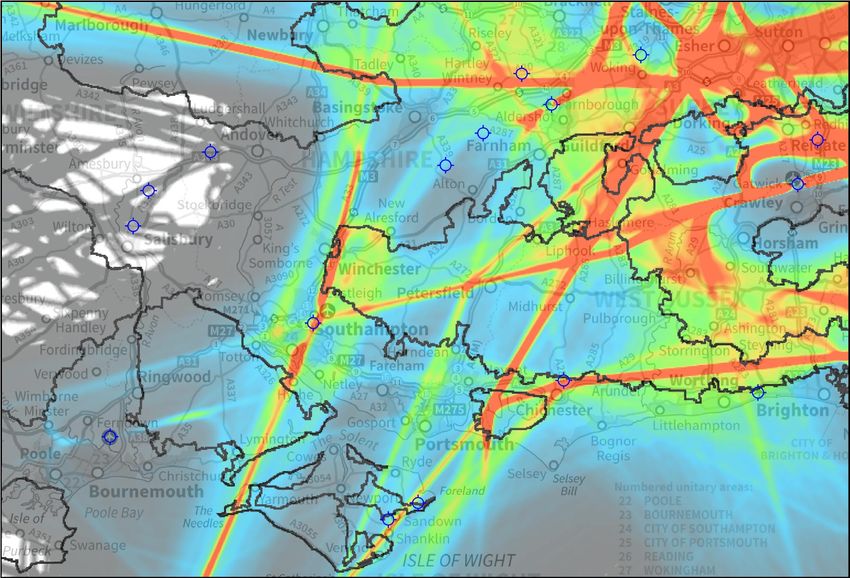
Density plots
1.14. In order to illustrate where aircraft currently fly, we have provided maps
overlaid with aircraft flight-paths, known as ‘density plots’. Density plots are
produced using radar data, and show how many aircraft over-flew a
particular place.
1.15. Density plots in this consultation show all commercial flights, to and from all
airports (not just Farnborough), for one month in the region4. They give a
good representation of where flights are most concentrated, and are
averaged over the 30-day month.
A colour key explains the average number of flights per day over a particular place.
1.16. Figure A3 shows all flights from all airports up to 20,000ft, and Figure A4
shows the same with National Parks and Areas of Outstanding Natural
Beauty (AONBs) highlighted.
National Parks, AONBs, and tranquillity
1.17. We have outlined these nationally designated places in Figures A2 and A4,
and in Parts B, C and D. This will allow you to determine any change in
impact over these designated areas, which may be valued by some for their
tranquillity.
4 The month of September 2012 was chosen because it was a representative month for our air traffic, and was outside the London 2012 Olympics period.
During the Olympics, special airspace was applied to the London region for parts of July and August, meaning that the (special) flight-path patterns were
not representative of the flight-paths normally flown across the region.
Part A: Introduction and Overview Page A5
Airspace Consultation                                                                 General overview of airspace development

                                                                                           © TAG Farnborough
           Part B: Farnborough aircraft                                                    except Ordnance Survey data ©
           below 4,000ft                                                                   Crown copyright and database right 2013

           Part C: Farnborough aircraft
           4,000ft-7,000ft
           Part D: Southampton and
           Bournemouth arriving aircraft
           from the east 4,000ft-7,000ft
           Part D: Bournemouth arriving
           aircraft from the east 2,500ft-4,000ft

                                                                             Part B
                                                             Part C

                                                                      Part
                                                                       C

                                                                                 Part C

                               Part D               Part D

                                                                                                                          N
                                                                                                                      W       E
                                                                                                                          S

                                                                                          Use PDF zoom tools              Airfield
                                                                                           to study this map        Farnborough
                                                                                              more closely               Airport

          Figure A1 Consultation Areas Overview
Figure A1: Consultation areas overview

Page A6                                                                                        Part A: Introduction and Overview
General overview of airspace development                                                                                                       Airspace Consultation

                                                                                                                           © TAG Farnborough
         Part B: Farnborough aircraft                                                                                      except Ordnance Survey data ©
         below 4,000ft                                                                                                     Crown copyright and database right 2013

         Part C: Farnborough aircraft
         4,000ft-7,000ft                           North Wessex
                                                   Downs AONB
         Part D: Southampton and
         Bournemouth arriving aircraft                                                                                                  Surrey Hills
         from the east 4,000ft-7,000ft                                                                                                    AONB
         Part D: Bournemouth arriving
         aircraft from the east 2,500ft-4,000ft
                                                                                                       Surrey Hills
                                                                                                         AONB

                                                                                                          Part B
                                                                              Part C                                                          High Weald
                                                                                                         South Downs                            AONB
         Cranborne Chase &                                                                               National Park
        West Wiltshire Downs                                              South Downs
               AONB                                                       National Park
                                                                                          Part
                                                                                           C
                                    New Forest
                                   National Park                                                 South Downs     Part C
                                                                                                 National Park                          South    Downs
                                                                                                                                        National   Park

                             Part D                        Part D                                      Chichester
                                                                                                        Harbour
                                                                                                         AONB

                                                                                                                                                          N
                                                                                                                                                      W       E
                                                              Isle of Wight                                                                               S
                                                                  AONB
          Dorset
          AONB                                                                                                            Use PDF zoom tools              Airfield
                                                                                                          National Park    to study this map        Farnborough
                                                                                                               or AONB        more closely               Airport

       Figure A2 Consultation Areas Overview (National Parks and AONBs highlighted)
Figure A2: Consultation areas overview (National Parks and AONBs highlighted)

Part A: Introduction and Overview                                                                                                                                    Page A7
Airspace Consultation General overview of airspace development
© TAG Farnborough
KEY: Flights Per Day except Ordnance Survey data ©
More than 24 Crown copyright and database right 2013
>18 to 24
>12 to 18
>6 to 12
Up to 6 per day
Consultation Area
Outline
N
W E
S
Use PDF zoom tools Airfield
to study this map Farnborough
more closely Airport
Figure A3 All commercial air traffic to/from all airports (up to 20,000ft)
Figure A3: All commercial air traffic to/from all airports (up to 20,000ft)
Page A8 Part A: Introduction and OverviewGeneral overview of airspace development Airspace Consultation
© TAG Farnborough
KEY: Flights Per Day except Ordnance Survey data ©
More than 24 Crown copyright and database right 2013
>18 to 24
>12 to 18 North Wessex
>6 to 12 Downs AONB
Up to 6 per day
Surrey Hills
Consultation Area AONB
Outline
Surrey Hills
AONB
High Weald
South Downs AONB
Cranborne Chase & National Park
West Wiltshire Downs South Downs
AONB National Park
New Forest
National Park South Downs
National Park South Downs
National Park
Chichester
Harbour
AONB
N
W E
Isle of Wight S
AONB
Dorset
AONB Use PDF zoom tools Airfield
National Park
to study this map Farnborough
or AONB more closely Airport
Figure A4 All commercial air traffic to/from all airports (up to 20,000ft), National Parks and AONBs highlighted
Figure A4: All commercial air traffic to/from all airports (up to 20,000ft), National Parks and AONBs highlighted
Part A: Introduction and Overview Page A9Airspace Consultation General overview of airspace development
Other airspace consultations
1.18. NATS En-Route and London Gatwick Airport are jointly proposing route and
airspace changes – their consultation ends before this one launches. Some
of their consultation areas overlap with ours. We are working with NATS En-
Route and Gatwick to ensure that our designs complement one another, but
it should be noted that their proposals (and consultations) are independent
from ours.
1.19. Likewise, Southampton Airport consulted on a minor change to their final
approach path for some of their arrivals from the south – that consultation
also ended before this one launches. There is no connection between
Southampton’s final approach consultation and ours, they are entirely
independent.
1.20. Search the internet for ‘London Airspace Consultation’ or ‘Southampton
Airport Consultation’ for more information on these proposals.
1.21. Stakeholders may have already responded to these other consultations, and
are also welcome to respond to ours.
Page A10 Part A: Introduction and OverviewStructure of the consultation documents Airspace Consultation
2. Structure of the consultation documents
2.1. This consultation document is structured in five parts plus appendices as
follows:
Part A – Introduction and overview (this part)
Part B – Changes affecting air traffic below 4,000ft in the vicinity of
Farnborough
Part C – Changes affecting air traffic between 4,000-7,000ft further away
from Farnborough
Part D – Changes affecting arriving air traffic from the east, between 2,500-
7,000ft, in the vicinity of Southampton and Bournemouth
Part E – Technical information for aviation stakeholders
Appendices A, B and C.
2.2. This is Part A. In this part, we provide:
A general overview of airspace development
An overview of the consultation areas and the consultation document so that
you can identify which parts may be of interest to you
Context for the consultation
How to respond to the consultation; and
What happens next.
2.3. After these sections, we have included more detailed background on the
following:
An overview of how Air Traffic Control (ATC) at Farnborough operates
An aviation-specialist introduction to the proposal
A description of the overall environmental effects the proposed changes
might have; and
The airspace design options that were considered.
Part A: Introduction and Overview Page A11Airspace Consultation Context for the consultation
3. Context for the consultation
3.1. This consultation will detail the proposal to establish airspace structures to
protect formal departure and arrival routes by using ‘RNAV’ navigation
standards. RNAV is the most common high-accuracy navigation standard for
which there is procedure design guidance.
3.2. This section describes the strategy and legislation driving the proposed
changes, the legal framework that determines how changes should be made,
and how these relate to potential benefits and effects.
Modernising UK Airspace
3.3. Achieving efficiency means, among other things, taking advantage of the
latest technology. To ensure that aviation across the UK does this, the CAA
has been working with the aviation industry to develop the Future Airspace
Strategy (FAS5), a blueprint for modernising the UK's airspace.
3.4. The UK's airspace infrastructure is currently predicated on 'conventional'
navigation, using radio beacons sited at various locations around the UK,
broadcasting radio waves that aircraft systems interpret and navigate via.
This system has been in place for many decades and does not exploit the
modern navigational capabilities with which most commercial aircraft are
already equipped (e.g. satellite technology). It is less precise, and therefore
relatively inefficient, both operationally and environmentally.
3.5. Modernisation of the airspace system is essential for the UK and continental
Europe to remain competitive in the global market. Processes are underway
at a European level to make modernisation a legal requirement for the UK
and other European states by 2020. Ignoring modernisation is therefore not
an option.
3.6. Modernisation will also enable UK aviation to reap the benefits of the latest
technologies such as Performance Based Navigation (PBN) 6. A route system
using PBN standards allows more flexible positioning of routes and enables
aircraft to fly them more accurately. This helps improve operational
performance in terms of safety and capacity, and also offers environmental
benefits.
3.7. Environmental benefits from PBN come from increased flexibility of route
design; noise can be better managed by positioning some routes away from
population centres or other sensitive areas, whilst also enabling us to seek
an optimal design in terms of route efficiency to minimise fuel used and CO 2
emissions. Modernising the system can also help improve resilience by
minimising the impact of unpredictable events such as bad weather.
3.8. FAS, and the upcoming European legislation, means that change to a PBN
airspace environment is inevitable and outside the scope of this consultation.
Our focus is on how best to apply this upcoming change, given that we have
been granted planning permission for more aircraft movements.
5 The CAA explains the background to FAS here: www.caa.co.uk/default.aspx?catid=2408
6 PBN is a generic term for modern air navigation standards. See Part E for technical information.
Page A12 Part A: Introduction and OverviewContext for the consultation Airspace Consultation
3.9. The recommendations made by the Airports Commission (chaired by Sir
Howard Davies) are likely to eventually require more changes to the airspace
system. The breadth of the required airspace changes will be entirely
dependent on whatever option is ultimately chosen by the Government. Any
such changes would be the subject of their own (separate) process and
consultation at a later date.
3.10. In the longer term, we may consider minor technical refinements to the
departure and arrival routes, using a navigation standard called RNP1, that
could improve flight management efficiency even more than this proposal.
Guidance for the design of RNP1-standard procedures is not yet fully
developed within the UK, but it has potential to be even more accurate than
RNAV, and would almost certainly narrow the track keeping accuracy of
RNAV routes even further.
3.11. This could mean small changes to the tracks flown (compared to the ones
proposed here and ultimately implemented, if approved). If these future
RNP1 refinements do require significant changes to the proposed RNAV
tracks, we would hold an additional consultation with those potentially
affected.
3.12. The CAA will provide guidance to us on what a ‘significant change’ would be,
if we decide to proceed with RNP1 or any other system in the future.
3.13. We undertake to maintain our engagement with both our local Farnborough
Airport Consultative Committee (FACC) and other relevant National Air
Traffic Management Advisory Committee (NATMAC) members regarding this.
Legal framework
3.14. The CAA regulates all airspace in the UK. Airspace change proposals must
be submitted by the change sponsor to the CAA for approval. The CAA is
required to consider a framework of legislation, standards and Government
guidance. These set out the CAA's obligations, and the factors that it must
take into account in assessing the merits of an airspace change proposal.
3.15. The CAA's primary obligation is to ensure that air navigation service
providers (TAG Farnborough in this case) exercise their air navigation
functions so as to maintain a high standard of safety in the provision of air
traffic services. This duty, which is imposed on the CAA by the Transport Act
2000, takes priority over all of the CAA's other duties.
3.16. The Transport Act also directs the CAA to exercise it’s air navigation
functions to:
a. secure the most efficient use of airspace consistent with the safe
operation of aircraft and the expeditious flow of air traffic
b. satisfy the requirements of all airspace users; and
c. take account of Government guidance on environmental objectives 7.
7 See Appendix A for references
Part A: Introduction and Overview Page A13Airspace Consultation Context for the consultation
3.17. In addition to the duties imposed by the Transport Act, the CAA is obliged to
take into account the need to reduce, control and mitigate as far as possible
the environmental effects of civil aircraft operations, and the need for
environmental effects to be considered at the earliest possible stages of
planning, designing, and revising airspace procedures and arrangements.
3.18. We have sought to reflect these duties and objectives, and the framework as
a whole, in our development of this proposal and this consultation. We also
take into account Government guidance on environmental objectives. This
sets out a number of environmental objectives, in relation to:
Greenhouse gas emissions and ozone depleting substances
Local air pollution
Noise (particularly in relation to aircraft below 7,000ft); and
Tranquillity.
3.19. In our judgement, the way in which these objectives are best balanced is as
follows:
In low altitude airspace (below 4,000ft, discussed in Parts B and D), the
environmental priority should be to minimise aviation noise impact, and the
number of people on the ground significantly affected by it, whilst imposing
the fewest possible restrictions to GA
In intermediate airspace (from 4,000ft to 7,000ft, discussed in Parts C
and D), the focus should continue to be minimising the impact of aviation
noise on densely populated areas, but this should be balanced with the need
for a predictable, efficient flow of air traffic that minimises CO2 emissions as
far as practicable
Where practicable, and without a significant detrimental effect on efficient
aircraft operations or noise impact on populated areas, flight-paths below
7,000ft should, where possible, be avoided over Areas of Outstanding
Natural Beauty (AONBs) and National Parks; and
Where route options are similar below 4,000ft in terms of their effect on
densely populated areas, the value of maintaining legacy arrangements
should be taken into consideration.
3.20. Airspace change sponsors must also take into account the guidance
published by the CAA entitled 'CAP725 CAA Guidance on the Application of
the Airspace Change Process'8. This guidance states that the environmental
impact of an airspace change must be considered from the outset, which we
have done and continue to do.
3.21. In considering the design of airspace we take account of the environmental
effects in the current system, and the effects that we would expect to occur
after implementation, should this proposal be approved and implemented.
8 See Appendix A for references
Page A14 Part A: Introduction and OverviewContext for the consultation Airspace Consultation
3.22. These are represented in the consultation material respectively by:
Density plots, showing the location of current air traffic; and
Diagrams and maps showing where routes are planned to be positioned.
3.23. We have considered these effects for populated areas and AONBs/National
Parks and will consider areas that are highlighted to us through the
consultation process. We seek to mitigate the local environmental impact on
these areas as best we can within the local airspace and operational
constraints, referring to the legal framework set out above.
Part A: Introduction and Overview Page A15Airspace Consultation Consultation overview
4. Consultation overview
4.1. The objective of this consultation is to enable us to collect as much
information as possible about what all the stakeholders want from the
airspace.
4.2. To that end this consultation document explains how aircraft currently use
the airspace, and what effects the proposed changes are likely to have. We
also explain the constraints within which we must work.
4.3. The views we seek include those from:
Farnborough airport users that fly through the airspace
Southampton and Bournemouth airport users that fly through the airspace
Representatives of people living under all these flight-paths, for example
where the new flight-paths might reduce over-flight, and where they might
increase over-flight
Environmental or special interest groups; and
GA and recreational flyers such as private pilots, gliders and balloonists.
4.4. This consultation is, however, open to all and we would welcome views from
anyone who has an interest, whether an individual or representing a group
or organisation.
Consultation on local impacts
4.5. Understanding stakeholder requirements is key to striking a balance of
benefits and impacts; locally relevant information is therefore the main focus
of this consultation.
4.6. In Parts B, C and D of this consultation document we provide maps of the
areas and corridors within which the routes are planned to be positioned,
and explain the reasons why they are there, including any unavoidable
constraints.
4.7. We provide information on the scale of potential impacts, particularly noise,
if a route was positioned overhead.
4.8. This will describe:
The potential number (and the likeliest types) of aircraft that would use the
proposed route
The lowest altitude they would most likely be
A measurement of how loud aircraft types at that altitude typically sound,
which is known as 'Lmax'.
4.9. We also include information about everyday sounds that are broadly
equivalent in perceived volume, so you can understand the potential impact.
Page A16 Part A: Introduction and OverviewConsultation overview Airspace Consultation
4.10. This information will allow you to identify the differences between what
happens today and what is likely to result from this proposal, and whether
you consider the change in impact to be significant to you.
4.11. In Parts B, C and D of this consultation document we ask you questions
about how you think the proposed changes might affect your interests -
these may be positive, negative, or not make much difference to you. We
would like to hear about all of them, even if you think it will not affect you.
Consultation on impacts to the aviation community
4.12. Details of the potential benefits and impacts on different aviation user
groups are presented in Part E, including explanations of the constraints and
balances we have to make between conflicting priorities and requirements.
The aviation users range from airlines through to private light aircraft pilots,
glider pilots, parachutists, paragliders, balloonists and anyone flying in the
vicinity of Farnborough, Southampton and Bournemouth airports.
4.13. We ask questions about the potential benefits and impacts on the aviation
community. This will allow us to gain an understanding of their
requirements.
4.14. As described later (paragraph 10.22), Farnborough is sacrificing fuel
efficiency for some of its flights in order to accommodate GA as far as is
practicable, given the constraints within which we must operate. We ask
your opinion on this.
Airspace design technicalities
4.15. It is not necessary to understand the technicalities of airspace design in
order to respond to this consultation. Parts B, C and D have been designed
to provide non-technical (as far as possible) information to describe the
effect our proposal would have on flight-paths, and what that might mean
for where you live or work, or how you fly your aircraft. However, for those
interested in the technical details behind this proposal we provide additional
detail in Sections 8 to 10 of this introduction and in Part E.
Consultation questions
4.16. The questions we ask in this consultation fall into four general categories:
Justification: In each part of the consultation document, we describe the
routes we are seeking to implement and the likely benefits and impacts. We
ask you to consider our objectives and respond accordingly, given the
system-wide impacts and benefits we expect them to generate if
implemented.
Balance: The detailed design process involves balancing benefits and
impacts against one another. In many cases, the optimal solution for one
benefit/impact means a suboptimal solution for another type (an example is
discussed later, where we consider the increased fuel consumption and CO2
Part A: Introduction and Overview Page A17Airspace Consultation Consultation overview
impact of longer routes that avoid populated areas and dense GA areas).
We ask you to consider our objectives and respond accordingly, having
regard for the principles for balancing benefits and impacts.
Identifying specific local requirements: Your local knowledge is
valuable and we ask you to feed back details of any location that requires
special consideration in the ongoing design process, and the reasons why
we should consider it special.
Aviation technical: Changes to airspace inevitably change the way
pilots fly their aircraft. We ask the aviation industry in general, and those
with an interest in the technical aspects of airspace design, to consider
the proposal in relation to their requirements and answer the questions in
Part E.
4.17. Questions are highlighted in a box like this, throughout the consultation
material, and are also provided in the website response form.
Example Question A1 (this is what the questions look like in these documents)
We recap part of the text, and ask you to consider what you have just read.
We ask you a question that lets us understand your point of view on the subject.
Most questions involve us making a statement, and asking you to declare how
strongly you agree/support or disagree/oppose it.
When we ask about specific places affected, and we ask you to tell us about it in a
particular way so we can understand where it is, what type of place it is, and what
the change in impact to that place would be if the proposal was implemented.
In all cases, you are welcome to add a supporting statement if you wish.
Part A contains no questions.
What are we not consulting on?
4.18. The scope of this consultation is limited to acquiring feedback about the
possible impact on stakeholders due to the proposed introduction of routes
and associated CAS for TAG Farnborough Airport.
4.19. This includes the consequential effects on some Southampton and
Bournemouth arrivals using a route from the east.
4.20. We are not seeking feedback on:
The planning decision to allow up to 50,000 movements at Farnborough;
Government and/or CAA policy, and their guidance on aviation matters
including FAS and PBN - we must follow their policy and guidance;
The Airports Commission (chaired by Sir Howard Davies); or
Other subjects that fall outside the scope described above.
4.21. There are, therefore, no questions on issues that are outside the scope of
this particular consultation. The receipt of all responses will be logged, but
Page A18 Part A: Introduction and OverviewConsultation overview Airspace Consultation
those responses concerning issues outside the scope of this consultation will
not be acted upon.
Who are we consulting?
4.22. This consultation is open to any group, organisation or individual that
considers themselves to be a stakeholder, including the general public.
4.23. Appendix C lists the groups and organisations that have already been
notified of this consultation. These groups have been directed to the
consultation website for further information and the opportunity to respond.
This list is not exhaustive - we know there will be many other interested
organisations or individuals that wish to respond.
4.24. If you think you or your organisation may be affected by this proposal, we
will be pleased to receive your responses to the questions we ask. We have
publicised the availability of the consultation document via our website:
www.Consultation.TAGFarnboroughAirport.com
and via other media.
4.25. Representative groups are invited to publicise this web link on their own
websites.
Part A: Introduction and Overview Page A19Airspace Consultation Responding to the consultation
5. Responding to the consultation
5.1. We regret we cannot enter into correspondence with individual respondents
on issues relating to this consultation. We have taken great care to provide
all the information we believe is required to help you answer the questions
presented in this consultation material. Where we consider that additional
information may be useful, whether it is raised in a response from a
stakeholder or comes to our attention through other channels, we will add it
to the Frequently Asked Questions (FAQs) section of the consultation
website, so that the information is available to everyone.
The online response form
5.2. Please respond using the online response form which can be found at:
www.Consultation.TAGFarnboroughAirport.com
5.3. This consultation launches 09:00 Monday 3rd February, and closes 23:00
Friday 2nd May 2014. This is just under thirteen weeks.
5.4. You are encouraged to use the postcode search facility provided on the
website to help you identify the relevant part(s) of the material, and to
consider those parts that meet your interests.
5.5. We welcome those responses that study the proposal as a whole, but we
understand that not all parts of the proposal will interest all stakeholders.
Please remember that we are interested in your response even if you do not
think it will affect you - that fact itself is useful to us.
Postal (paper) responses
5.6. The online response form is the quickest, most secure and easiest method of
responding. However, we understand that not everyone is able to use this
method. If you prefer, you may respond by post to the address below:
Farnborough Airspace Consultation Responses
PO Box 584
Hounslow
TW3 9QP
Please be aware that we cannot guarantee that responses submitted directly or
indirectly by any other means of delivery will be accounted for in the consultation
exercise.
Regarding postal (paper) responses:
5.7. Please seek to answer the questions we ask in this consultation document.
Page A20 Part A: Introduction and OverviewResponding to the consultation Airspace Consultation
5.8. We are unable to acknowledge receipt of postal responses (even if you
enclose a pre-addressed envelope) – if delivery confirmation is required we
recommend that you use a recorded delivery service so that you can be sure
your response has reached us.
5.9. Provide a clear indication of your area of interest to ensure we categorise it
correctly. If you have a particular local interest you could provide the
postcode of that area (if different from your home or business address), or
you could refer to the part of the consultation document where it is
discussed (Parts B, C, D or E). Alternatively your interest may be best
described as a subject or theme, such as 'global climate change effects' or
‘noise’ or ‘light aviation'. You are welcome to identify a range of interests.
5.10. Similarly, if your feedback relates to a specific question we have asked, you
should tell us which question you're answering. Questions in the
consultation material are individually numbered and highlighted in a box like
this.
5.11. Failure to clearly match your comment to a question we ask (or to a specific
area of interest, subject or theme) could mean that your response is not
associated with your intended issue - this may reduce its effectiveness.
5.12. Please ensure you allow adequate time when you post your response. Postal
responses received after the consultation closes will be logged and stored,
but not analysed. We cannot be held responsible for postal responses that
arrive late, whatever the reason.
5.13. All feedback is welcomed and will be treated equitably regardless of origin or
delivery medium - however, please do answer the questions asked, because
that will be the most effective way of responding.
What happens to my response, and my personal information?
5.14. In order to provide a meaningful response, we need to know your name,
home address or business address, and for online responses we need the
email address to which the automatic copy of your response should be sent.
5.15. All the feedback from the consultation will be made available to the CAA as
part of our airspace change proposal. This will allow them to assess
independently whether we have drawn appropriate conclusions in the
development of the proposed design.
5.16. Responses will be treated with due care and sensitivity by us, by the
consultation specialists we employ, and by the CAA.
5.17. If you do not wish your personal details (e.g. name/full address) to be
forwarded to the CAA, our online response form has an 'anonymous' check
box.
5.18. This will not make your response anonymous to us, rather it tells us that we
need to make your response appear anonymous to the CAA before we
forward it to them. Instead, your postcode and unique ID reference number
will be sent to the CAA, who will not have the decoding list.
Part A: Introduction and Overview Page A21Airspace Consultation Responding to the consultation
5.19. If you send a paper response, please make it clear right at the beginning
whether you wish us to make your submission anonymous before we pass it
to the CAA.
5.20. Apart from the CAA, we undertake not to disclose personal data to any other
party without prior permission. We, the consultation specialists we employ,
and the CAA are all bound by the Data Protection Act.
Page A22 Part A: Introduction and OverviewCompliance with the consultation process Airspace Consultation
6. Compliance with the consultation process
6.1. The legal framework for this consultation is detailed from paragraph 3.14.
6.2. Comments regarding the Airspace Charter (CAP724, see Appendix A) and
our compliance with the consultation process as set out in the CAA's
guidelines for airspace change (CAP725, see Appendix A) should be directed
to the CAA at:
Airspace Business Coordinator - Airspace, ATM and Aerodromes
Re: Farnborough Airspace Consultation
Safety and Airspace Regulation Group
CAA House
45-59 Kingsway
London WC2B 6TE
E-mail: airspace.policy@caa.co.uk
6.3. These contact details must not be used for your response to this
consultation. If you do so, your views may not be counted, or they may be
significantly delayed.
Part A: Introduction and Overview Page A23Airspace Consultation Next steps
7. Next steps
Feedback analysis
7.1. We will take your relevant feedback and analyse it, balancing safety,
operational requirements and constraints, benefits/disbenefits and
competing feedback from other respondents. We will take into account
guidance from the Government and the CAA.
The feedback report
7.2. A summary of the issues raised in the consultation, including any revisions to
the proposal based on the analysis, will be provided in a feedback report to
be published on our website, probably between four and eight weeks after
the end of the consultation.
7.3. The website will be updated to inform everyone about the expected
publication date of this report.
7.4. The report will also provide further details of next steps in the airspace
change process. This will most likely involve the preparation and submission
of an Airspace Change Proposal (ACP) to the CAA, which is a technical
document.
Planned implementation date
7.5. Subject to many factors including the results of this consultation, we
currently plan to implement the airspace change in the first quarter of 2015.
In this consultation we have provided forecast air traffic data for 2015 and
2019.
The following sections contain more detailed background information
about air traffic control, runways, aviation overview, the rationale behind
our proposal, environmental impacts and other design options.
Page A24 Part A: Introduction and OverviewOverview of Air Traffic Control (ATC) at Farnborough Airspace Consultation
8. Overview of Air Traffic Control (ATC) at Farnborough
The remainder of this introductory Part of the consultation document aims to provide
background information on the proposal. It is not necessary for stakeholders who have only
an interest in the local impacts of the proposal to read these following sections; if your
interest is only in local impacts, you should use the maps in Figures A1 and A2 to identify
which of the Parts B, C and/or D are of interest and go directly to those parts. However, if
you wish to gain an understanding of the background, rationale and objectives behind our
proposal you should continue reading this and the subsequent sections of this part of the
consultation document.
We have aimed to provide explanations that can be understood by those without a technical
aviation background, and as such we describe aviation terms as they are introduced.
However, it should be noted that whilst we have endeavoured to simplify this as much as
possible, air traffic control and aviation in general is a technical subject area.
If you have an interest in the aviation background you may wish to skip to paragraph 9.1
below, which briefly introduces the proposal from a pilot/ATC point of view. A full aviation
technical discussion of the proposal can be found in Part E.
What is ‘airspace’?
8.1. Airspace is everywhere above us; however for air traffic purposes it is split
into different types and classifications that dictate who can fly in it, and the
role of ATC in that classification. The main types are ‘controlled airspace’
where ATC is responsible for directing all aircraft and ‘uncontrolled’ airspace
where they are not. Only aircraft that have submitted a plan to fly, or who
have had a request for entry accepted by ATC, may fly within controlled
airspace – this means it is primarily used by aircraft that fly passengers and
goods. Uncontrolled airspace is open to all flyers, including the
passenger/goods flights but also GA; the microlights, balloonists and
recreational flyers who don’t have to communicate with ATC. ATC still
provides a service to aircraft in this airspace, but because they are not
controlling all the aircraft it is generically referred to as ‘uncontrolled’.
8.2. Controlled airspace is generically referred to as ‘CAS’ and is further split into
classifications (A to E) which dictate the kind of ATC service provided within
– these are described later in paragraph 8.11. Uncontrolled airspace is also
referred to as Class G airspace when using this classification scheme.
8.3. Farnborough currently lies outside CAS, within airspace categorised as
Class G (uncontrolled) airspace.
Part A: Introduction and Overview Page A25Airspace Consultation Overview of Air Traffic Control (ATC) at Farnborough
8.4. An Aerodrome Traffic Zone (ATZ) is a circle9 established around the airport
with a radius of 2.5 nautical miles10 (nm) from the Aerodrome Reference
Point (ARP, defined as the centre of the runway). The ATZ extends from the
surface to 2,000ft above the runway, which itself is 238ft above mean sea
level, making the altitude of the top of our ATZ 2,238ft. Our ATZ extends to
approximately 2nm along the final arrival and departure paths and is the
only airspace within which all aircraft are required to make their presence
known to ATC at Farnborough, and must comply with ATC instructions.
Between 2,239ft and 3,499ft directly above us, any aircraft may fly anytime
without speaking to any ATS provider. Figure A5 on Page A27 illustrates
Farnborough and Blackbushe ATZs. Most airports in the vicinity, shown by
the blue circles with crosshairs, have a circular ATZ like this (including
Heathrow, Gatwick and others with or without existing CAS).
8.5. From an altitude of 3,500ft upwards, Farnborough is overlaid with CAS
classified as Class A (see paragraph 8.11). This area is known as the London
Terminal Manoeuvring Area (LTMA). The LTMA is under the control of NATS
En-Route at London Terminal Control (LTC), Swanwick, Hampshire, and has
been established and developed over many years to serve the high-density
air traffic operations routing to and from all the major London airports.
8.6. Changes to CAS proposed around Farnborough airport are illustrated in
Figure A5 overleaf and are briefly described below, for an audience without a
specific aviation technical background. Existing unchanged CAS is not shown
in this map.
8.7. Aviation specialists may wish to skip to paragraph 9.1 onwards, from Page
A33, where there is also an extract from a UK CAS VFR chart.
8.8. The consultation areas shown previously in Figure A1 are generally much
wider than the CAS changes shown overleaf in Figure A5. This is because
the effect of the proposed routes and CAS near an airport can cause changes
to aircraft flight-paths much further away.
8.9. Regarding the volumes of CAS shown in Figure A5 overleaf:
a. Shaded orange area from ground level, known as a ‘Control Zone’ (CTR)
b. Orange outlined areas start above the ground, ending below 4,000ft -
these are ‘Control Areas’ (referred to as CTAs)
c. Blue dashed outlined area indicates part of Gatwick’s CTA we are
considering removing from current use, subject to ongoing negotiations
(this is most relevant to stakeholders with an aviation technical interest)
d. Black outlined areas start above 4,000ft and link the airport with the
main route system 7,000ft and above (also CTAs)
9 Because Blackbushe Airport is close by, and has its own ATZ, these ATZs are separated using the M3 motorway as the boundary. Blackbushe has a
slightly smaller ATZ (2nm radius) because its runway is shorter.
10 Aviation measures distances in nautical miles. One nautical mile (nm) is 1,852 metres. One ‘road’ mile (statute mile) is 1,609 metres, making a
nautical mile about 15% longer than a road mile.
Page A26 Part A: Introduction and OverviewOverview of Air Traffic Control (ATC) at Farnborough Airspace Consultation
e. Pink outlined areas are proposed changes to ‘airways’. These are routes
in the sky, and these ones converge towards southwest London.
Changes here would affect aircraft 7,000ft and higher in the en-route
phase of flight, but would also enable flight-path changes in lower
volumes of airspace such as Southampton and Bournemouth arrivals (see
Part D).
N
W E 4,000ft-
S 7,000ft
Blackbushe ATZ
No change
Airfield
Farnborough ATZ
No change
Below GA only
4,000ft below
2,500ft
4,000ft-
7,000ft
7,000ft and
higher (airways)
Airfield
Use PDF zoom tools © TAG Farnborough
to study this map except Ordnance Survey data ©
more closely Crown copyright and database right 2013
Figure A5 Proposed changes to these volumes of CAS
Figure A5: Proposed changes to these volumes of CAS
8.10. Everywhere in Figure A5 is covered in airspace, air routes, or some other
sort of airspace structure. Only the changing volumes are shown here.
8.11. Airspace is defined in accordance with an internationally agreed set of
categories, by the International Civil Aviation Organization (ICAO, part of the
United Nations family of organizations). The most restrictive, Class A
airspace, is generally used where protecting commercial traffic at higher
altitudes is most important. There are specific pilot qualification and aircraft
equipment requirements for operating in Class A, and all aircraft are under
ATC control. Most airways are Class A, as is most of the London TMA.
Part A: Introduction and Overview Page A27Airspace Consultation Overview of Air Traffic Control (ATC) at Farnborough
8.12. The least restrictive classification, Class G, is uncontrolled airspace. Anyone
may fly there, in any type of aircraft, at any time, without speaking to any
air traffic organisation, by following the most basic of rules.
8.13. Class G is the default classification for UK airspace, unless a higher class is
needed for a specific reason such as to protect an airport or air route. The
establishment of CAS would mean changes to the Class G environment used
by GA.
8.14. The most commonly used CAS classifications in the UK are Classes A and D,
with some Class C.
8.15. Most UK airports that have associated CAS use a control zone (CTR) and
CTAs of Class D airspace around the airport, because these provide
protection for the operations of the airport, yet still allow access to GA traffic
(with ATC permission). This is what we are applying for, and is the reason
for this consultation.
ATC in the vicinity of Farnborough
8.16. Currently Farnborough Airport does not have dedicated permanent 11 CAS,
and there are currently no formal routes directly linking the runways with the
air route network. All airport traffic is directed manually by air traffic
controllers in this outside-CAS environment.
8.17. Most busy airports benefit from the protection for air traffic provided by CAS.
Heathrow, Gatwick, Southampton, Bournemouth and London City are the
five nearest airports to Farnborough with CAS.
8.18. In addition to controlling aircraft departing from and arriving at TAG
Farnborough Airport, the responsibilities of ATC at the airport include the
Lower Airspace Radar Service (LARS). This is for participating General
Aviation (GA12) in a very wide area surrounding London (extending from
Didcot to Letchworth to Braintree and Maidstone, to Eastbourne and along
the south coast to Portsmouth round to Andover). LARS gives participating
aircraft flight information on request, such as weather or the proximity of
other air traffic known to ATC.
8.19. There is no requirement for GA aircraft to communicate with any ATS
agency provided they remain outside CAS, either horizontally or vertically -
indeed, that freedom is part of the appeal for many GA pilots. Whilst the
airspace surrounding London is amongst the busiest and most complex in
the world, the uncontrolled classification of the airspace surrounding
Farnborough means that currently the airspace is used by a wide variety of
aircraft ranging from gliders and microlights to large jet aircraft (e.g.
Boeings and Airbuses).
8.20. There is no requirement for GA aircraft to cooperate with ATC if they are
operating outside CAS, even though they may be participating in an ATS.
They may be unable to comply for reasons such as weather issues,
incompatibility with the task they are performing, pilot qualification, aircraft
equipment and others.
11 Special (but temporary) airspace is established for the biennial Farnborough International Air Show and for other reasons if required.
12 See Footnote 3 on Page A4 for more information about GA.
Page A28 Part A: Introduction and OverviewOverview of Air Traffic Control (ATC) at Farnborough Airspace Consultation
8.21. GA aircraft, whether participating in LARS or not, mix with arriving and
departing Farnborough air traffic in this outside-CAS environment.
Farnborough ATC manages this to the highest safety standards, even though
some of the GA traffic may not be speaking with them and may therefore
only be seen as a radar target (often known as a 'blip') with unknown
intentions (these are referred to as ‘unknown traffic’, as opposed to ‘known
traffic’ which are flights that have made contact with ATC).
8.22. Avoiding these non-participating radar blips (or those unable to cooperate) is
routine, and the ATC team does this daily. Whilst working around them is
safe, it compromises the efficiency and predictability of Farnborough aircraft,
other aircraft receiving an air traffic service from LARS, and neighbouring
airports.
8.23. The effect of this is that some arrivals to Farnborough are instructed to fly
longer distances at inefficient altitudes to avoid unknown aircraft, and some
departures can be held on the ground until the unknown aircraft moves away
or an alternate route can be offered by the radar controller (or if already
airborne, the departure might need to be detoured). This causes delay and
more fuel is burnt than planned (increasing CO2 emissions13 unnecessarily).
Also, aircraft that are forced to stay at low altitudes on these extended
routes or detours (whether departing or arriving) produce more noticeable
noise.
8.24. It is not just Farnborough aircraft that are displaced due to the complexity of
the local airspace and non-participating aircraft. It also means that, for
example, small slow GA aircraft might suddenly encounter a much larger
faster aircraft than they would normally expect to see. A gliding competition
could be disrupted by RAF helicopters having to move to new areas.
Pleasure flights could need to route elsewhere due to intense microlight
activity.
8.25. These 'knock-on' consequences are almost always invisible to the
unknown/non-participating aircraft.
8.26. This is not the most efficient way of managing the wider air traffic situation
in the vicinity of Farnborough, because the airspace environment is not
predictable, so it cannot be automated or systemised14.
8.27. In February 2011, the Government granted TAG planning permission to
increase the maximum annual number of aircraft movements 15 to 50,000 to
the year 2019.
8.28. Now that Farnborough has planning permission for more movements, it is
important for all users that the airspace becomes more efficient and
predictable whilst maintaining as much freedom for GA as possible, and
retaining or enhancing the highest safety standards.
13 Burning fossil fuel means that CO2 is produced. For aviation fuel, 1kg of fuel burnt typically means 3.18kg of CO 2 is emitted.
14 Systemisation of the airspace environment means that aircraft operators can plan and predict their take-off and landing times, and their fuel
calculations, much more accurately. It also reduces workload for the pilot and the controller.
15 One aircraft ‘movement’ is either a landing or a take-off. An aircraft landing, dropping off or collecting passengers, then taking off again counts as
two movements.
Part A: Introduction and Overview Page A29Airspace Consultation Overview of Air Traffic Control (ATC) at Farnborough
8.29. It is also crucial that any changes we propose ‘fit’ with the main air route
network and neighbouring airports. Changes in one area can affect flight-
paths elsewhere, sometimes a long way away. We can take the opportunity
to help make the wider airspace management more efficient for others as
well as just for ourselves.
8.30. We propose that the introduction of CAS and routes, as detailed in this
consultation, would fulfil this need for predictability and efficiency of airspace
management. The planning permission's allowance for an increase in
aircraft movements could not be accommodated in the current airspace
system without imposing additional delays.
What is a ‘runway’? How are they used now, and in the future?
8.31. Farnborough has one long stretch of concrete and asphalt which aircraft use
to take off and land. However, because it can be used in either direction,
this length of concrete is officially classed as being two runways (Runway 24
and Runway 06) 16.
8.32. Airspace near the airport is used by departing aircraft as they climb after
takeoff, and by arriving aircraft as they descend to land. The wind direction
on any given day (or hour) dictates which direction the runway is used for
take-off and landing. This in turn influences the traffic patterns seen in the
surrounding airspace.
8.33. If the wind is from the west or calm, aircraft take off and land using the
westerly facing runway (Runway 24) and if the wind is from the east they
take off and land using the easterly facing runway (Runway 06). Due to
local airspace restrictions and prevailing wind conditions, Runway 24 is used
approximately 80% of the time and Runway 06 used 20% of the time.
What proportions of Farnborough flights currently depart to, and
arrive from, each direction? Would this change under the proposal?
8.34. See Figure A6 below for an illustration of how Farnborough’s flights are
proportioned. The text following this illustration gives more detail on the
changes.
8.35. Note that Farnborough aircraft cannot fly directly to (or from) the east or
west. They instead fly north or south to join one of the air route networks,
or they arrive from one of the air route networks and fly towards
Farnborough from the north or south. This is a constraint imposed by the
route networks themselves and surrounding airports.
16 The runway numbers ‘24’ and ‘06’ refer to the magnetic heading an aircraft would display on its compass, if it was aligned with the runway centreline.
Farnborough’s runways are aligned 064° and 244°, abbreviated to 06 and 24. If possible, runways are usually aligned with the most common prevailing
wind direction, in the south of England this is usually from the west.
Page A30 Part A: Introduction and OverviewYou can also read