ANIMAL TELEMETRY NETWORK IMPLEMENTATION PLAN 2016-2021 - NATIONAL OCEAN COUNCIL December 2016
←
→
Page content transcription
If your browser does not render page correctly, please read the page content below
ANIMAL TELEMETRY NETWORK
IMPLEMENTATION PLAN 2016-2021

          PRODUCT OF THE
     NATIONAL OCEAN COUNCIL

         December 2016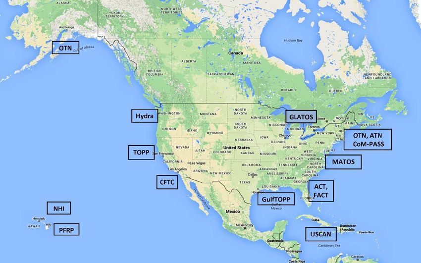
About the National Ocean Council
The National Ocean Council (NOC) is charged with implementing the National Ocean Policy established
in July 2010 under Executive Order 13547, Stewardship of the Ocean, Our Coasts, and the Great Lakes.
The NOC released the National Ocean Policy Implementation Plan in April 2013 to translate the National
Ocean Policy into specific actions Federal agencies will take to address key ocean challenges, streamline
Federal operations, save taxpayer dollars, and promote economic growth. Federal agencies, states,
tribes, and regional fishery management councils may choose to form regional planning bodies to
provide communities greater collaborative input in these efforts. More information is available at
www.whitehouse.gov/administration/eop/oceans.

About the National Science and Technology Council
The National Science and Technology Council (NSTC) is the principal means by which the Executive Branch
coordinates science and technology policy across the diverse entities that make up the Federal research
and development (R&D) enterprise. One of the NSTC’s primary objectives is establishing clear national
goals for Federal science and technology investments. NSTC prepares R&D packages aimed at
accomplishing multiple national goals. The NSTC’s work is organized under five committees: Environment,
Natural Resources, and Sustainability; Homeland and National Security; Science, Technology, Engineering,
and Mathematics (STEM) Education; Science; and Technology. Each of these committees oversees
subcommittees and working groups that are focused on different aspects of science and technology. More
information is available at www.whitehouse.gov/ostp/nstc.

About the Office of Science and Technology Policy
The Office of Science and Technology Policy (OSTP) was established by the National Science and
Technology Policy, Organization, and Priorities Act of 1976. OSTP’s responsibilities include advising the
President in policy formulation and budget development on questions in which science and technology
are important elements; articulating the President’s science and technology policy and programs; and
fostering strong partnerships among Federal, state, and local governments, and the scientific
communities in industry and academia. The Director of OSTP also serves as Assistant to the President for
Science and Technology and manages the NSTC. More information is available at
www.whitehouse.gov/ostp.

About the Council on Environmental Quality
The Council on Environmental Quality (CEQ) coordinates Federal environmental efforts and works closely
with agencies and other White House offices in the development of environmental policies and initiatives.
CEQ was established within the Executive Office of the President (EOP) by Congress as part of the National
Environmental Policy Act of 1969 (NEPA), and additional responsibilities were provided by the
Environmental Quality Improvement Act of 1970. Through interagency working groups and coordination
with other EOP components, CEQ works to advance the President’s agenda. It also balances competing
positions, and encourages government-wide coordination, bringing Federal agencies, state and local
governments, and other stakeholders together on matters relating to the environment, natural resources,
and energy. CEQ co-chairs the National Ocean Council, along with OSTP. More information is available at
www.whitehouse.gov/ceq.

                                                    iii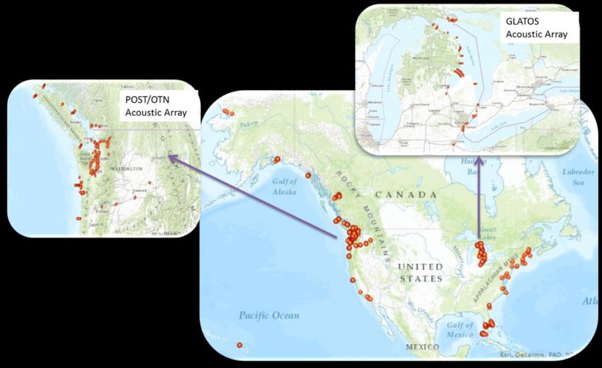
About the Subcommittee on Ocean Science and Technology
The purpose of the Subcommittee on Ocean Science and Technology (SOST) is to advise and assist on
national issues of ocean science and technology. The SOST contributes to the goals for Federal ocean
science and technology, including developing coordinated interagency strategies, and fosters national
ocean science and technology priorities. The SOST also serves as the Ocean Science and Technology
Interagency Policy Committee under the NOC, and ensures the interagency implementation of the
National Ocean Policy and other priorities for ocean science and technology objectives. More information
is available at www.whitehouse.gov/administration/eop/ostp/nstc/oceans.

About the Interagency Ocean Observations Committee
The purpose of the Interagency Ocean Observations Committee (IOOC) is to advise and assist the SOST on
matters related to ocean observations, including coordination of Federal activities on ocean observations
and other activities as described in the Integrated Coastal and Ocean Observation System Act of 2009 (P.L.
No. 111-11, Subtitle C).
About the IOOC Animal Telemetry Network Task Team
The IOOC established the Animal Telemetry Network Task Team (ATN-TT) to distribute and socialize the
Strategic Plan and Recommendations for a National Animal Telemetry Network (ATN) through U.S. IOOS
and develop an ATN implementation plan for aquatic species.
About this Document
This document was developed by the IOOC ATN-TT. The document was published by the NOC.
Acknowledgements
Special thanks to:
Mike Arendt, South Carolina Department of Natural Resources
Jerry Ault, University of Miami
Barbara Block, Stanford University
Daniel Costa, University of California, Santa Cruz
Kim Holland, University of Hawaii
Bruce Mate, Oregon State University
Molly McCammon, Alaska Ocean Observing System
Peter Moore, Mid-Atlantic Coastal Ocean Observing System
Kelli Paige, Great Lakes Ocean Observing System
John Payne, University of Washington
Andrew Seitz, University of Alaska Fairbanks
Doug Wilson, Caribbean Wind, LLC
Nicholas Rome, Consortium for Ocean Leadership
Hannah Dean, Consortium for Ocean Leadership

                                                    iv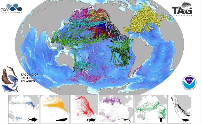
Copyright Information
This document is a work of the United States Government and is in the public domain (see 17 U.S.C. §105).
Subject to the stipulations below, it may be distributed and copied with acknowledgement to the NOC.
Copyrights to graphics included in this document are reserved by the original copyright holders or their
assignees and are used here under the government’s license and by permission. Requests to use any
images must be made to the provider identified in the image credits or to the NOC if no provider is
identified.
Printed in the United States of America, December 19, 2016

                                                   v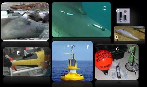
Report prepared by

                               NATIONAL OCEAN COUNCIL
                                       by the
                   SUBCOMMITTEE ON OCEAN SCIENCE AND TECHNOLOGY
                     INTERAGENCY OCEAN OBSERVATIONS COMMITTEE
                        ANIMAL TELEMETRY NETWORK TASK TEAM

                                           National Ocean Council
Co- Chairs                                                     Director
John P. Holdren                                                Deerin Babb-Brott
Assistant to the President for Science
and Technology and Director,
Office of Science and Technology Policy
Christina Goldfuss
Managing Director
Council on Environmental Quality

                                   National Ocean Council Deputies
Co-Chairs                                                      Deputy Director
Tamara Dickinson                                               Fabien Laurier
Principal Assistant Director for Environment and Energy        Office of Science and Technology Policy
Office of Science and Technology Policy

Whitley Saumweber
Associate Director for Oceans and Coasts
Council on Environmental Quality

                                      National Ocean Council Staff
Lindy Bunn                                                     Steve Baldovsky
Ocean Policy Advisor                                           Policy Analyst

   Ocean Science and Technology Interagency Policy Committee/Subcommittee on
                          Ocean Science and Technology
Co-Chairs                                                      Staff
Fabien Laurier                                                 Roxanne Nikolaus
Office of Science and Technology Policy                        National Science Foundation

Richard Merrick
National Oceanic and Atmospheric Administration
Richard W. Murray
National Science Foundation

                                                          vi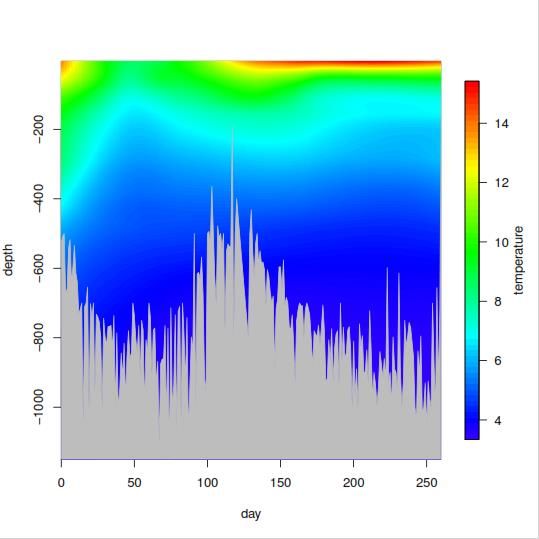
Interagency Ocean Observation Committee
Co-Chairs                                               Staff
Bauke H. Houtman                                        Nicholas Rome
National Science Foundation                             Consortium for Ocean Leadership

David Legler
National Oceanic and Atmospheric Administration

Eric Lindstrom
National Aeronautics and Space Administration

Members
Guillermo Auad
Bureau of Ocean Energy Management

Jon Berkson
United States Coast Guard

Paula Bontempi
National Aeronautics and Space Administration

Paul DiGiacomo
National Oceanic and Atmospheric
Administration

Jonathan Garber
Environmental Protection Agency

Carl Gouldman
National Oceanic and Atmospheric
Administration

John Haines
United States Geological Survey

Linda Lillycrop
United States Army Corps of Engineers

Brian Melzian
Environmental Protection Agency

Samantha Simmons
Marine Mammal Commission

Michael Weise
Office of Naval Research

                                                  vii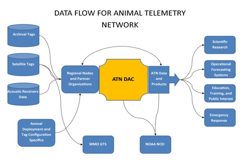
Animal Telemetry Network Implementation Plan 2016-2021

                           Interagency Ocean Observation Committee
                             Animal Telemetry Network Task Team
Co-Chairs
Michael Weise
Office of Naval Research

Hassan Moustahfid
National Oceanic and Atmospheric Administration

Members
Sean Hayes
National Oceanic and Atmospheric Administration
Christopher Holbrook
United States Geological Survey

John Kocik
National Oceanic and Atmospheric Administration

Jake Levenson
Bureau of Ocean Energy Management

Josh London
National Oceanic and Atmospheric Administration

Steve Lindley
National Oceanic and Atmospheric Administration

James Price
Bureau of Ocean Energy Management

Samantha Simmons
Marine Mammal Commission

                                              viii
Animal Telemetry Network Implementation Plan 2016-2021
National Ocean Council
Council on Environmental Quality
Office of Science and Technology Policy
Department of Agriculture
Department of Commerce
Department of Defense
Department of Energy
Department of Health and Human Services
Department of Homeland Security
Department of the Interior
Department of Justice
Department of Labor
Department of State
Department of Transportation
Environmental Protection Agency
Federal Energy Regulatory Commission
Joint Chiefs of Staff
National Aeronautics and Space Administration
National Oceanic and Atmospheric Administration
National Science Foundation
U.S. Army Corps of Engineers*
U.S. Coast Guard
Office of the Director of National Intelligence
Office of Management and Budget
Office of the Vice President
National Security Council Staff**
Domestic Policy Council
National Economic Council
* Member of the Deputy-level committee
** Includes the National Security Advisor and the Assistant to the President for Homeland Security and
Counterterrorism
ixAnimal Telemetry Network Implementation Plan 2016-2021
Table of Contents
Executive Summary....................................................................................................................................... 1
1. Background ............................................................................................................................................... 3
1.1 General Overview ............................................................................................................................... 3
1.2 Aquatic Animal Telemetry Applications .............................................................................................. 4
1.2.1 Fisheries and Protected Species Management ............................................................................ 5
1.2.2 Anthropogenic Disturbances ....................................................................................................... 5
1.2.3 Ocean Modeling ........................................................................................................................... 6
1.3 State of Aquatic Animal Telemetry Observing System and Technology ............................................. 6
1.4 Aquatic Animal Telemetry Data Requirements .................................................................................. 9
2. ATN Design .............................................................................................................................................. 11
2.1 Network Overview ............................................................................................................................ 11
2.2 Network Components ....................................................................................................................... 12
2.3 Phase I - Coordination ....................................................................................................................... 12
2.4 Phase I – Data Management System ................................................................................................ 13
2.4.1 ATN Data Flow System ............................................................................................................... 13
2.4.2 ATN DAC Web Display and Interface ......................................................................................... 14
2.4.3 DAC Data Products ..................................................................................................................... 16
2.4.4 ATN Relational Database Management Systems ....................................................................... 16
2.4.5 Data Element-level Metadata .................................................................................................... 16
2.4.6 Discovery–level Metadata ......................................................................................................... 17
2.4.7 Future Development of Metadata Standards ............................................................................ 17
2.4.8 ATN Data Archive and Stewardship ........................................................................................... 17
2.5 ATN Implementation Plan – Phase II ................................................................................................ 17
2.5.1 Infrastructure and Capability ..................................................................................................... 17
2.5.2 Baseline Aquatic Animal Telemetry Observations ..................................................................... 19
2.5.3 Resource Requirements for Sustained ATN Operations ............................................................ 20
3. ATN Data-Sharing Guidelines .................................................................................................................. 21
3.1 Guidelines – Federal Data ................................................................................................................. 21
3.2 Guidelines – Non‐Federal Data ......................................................................................................... 22
3.3 Data Submission to ATN DAC ............................................................................................................ 23
3.4 Responsibilities in Use of ATN Data .................................................................................................. 23
3.5 Sustainability and Availability ........................................................................................................... 24
xAnimal Telemetry Network Implementation Plan 2016-2021
3.6 Important Resources......................................................................................................................... 24
4. Governance ............................................................................................................................................. 24
4.1 Roles and Responsibilities ................................................................................................................. 24
4.1.1 Interagency Ocean Observation Committee ............................................................................. 24
4.1.2 ATN Steering Group ................................................................................................................... 24
4.1.3 U.S. Integrated Ocean Observing System Program Office ......................................................... 25
4.1.4 ATN Network Coordinator ......................................................................................................... 25
4.1.5 U.S. IOOS Regional Associations ................................................................................................ 26
4.1.6 Aquatic Animal Telemetry Programs and Individual Partners ................................................... 26
4.2 Environmental Compliance ............................................................................................................... 26
4.3 Performance Metrics ........................................................................................................................ 26
4.3.1 National Level ............................................................................................................................ 27
4.3.2 Regional Organizations .............................................................................................................. 27
5. Communications, Outreach, and Education ........................................................................................... 28
5.1 Communications and Outreach ........................................................................................................ 28
5.2 Education .......................................................................................................................................... 28
Appendix ..................................................................................................................................................... 29
References .................................................................................................................................................. 30
Abbreviations .............................................................................................................................................. 32
xiAnimal Telemetry Network Implementation Plan 2016-2021
Executive Summary
Aquatic animal telemetry is the science of elucidating the movements and behavior of animals as they move
through the world’s oceans, coastal rivers, estuaries, and Great Lakes. Current capacity to track aquatic
animals has found uses in many fields of marine science ranging from the study of animal behavior to the
study of the oceanic and freshwater systems these animals inhabit. In the past two decades, rapid advances
in transmitters, receivers, and data storage tags that are attached to animals have made it possible to collect
high-quality biological and oceanographic observations on timescales varying from days to years as the
animals move through aquatic habitats. These observations provide scientific information that is used to
inform the management of marine fisheries and endangered and protected species; assess the potential
effects of anthropogenic disturbances on aquatic species; and improve ocean modeling and forecasting.
The United States is a global leader in aquatic animal telemetry, with considerable telemetry infrastructure
and technical expertise in telemetry operations. These research assets, however, are often owned and
operated independently by multiple Federal agencies and non-Federal institutions with limited or no
connectivity. Lack of institutional connections prevents the scientific community from efficiently
coordinating data and thereby best serving societal needs. The Strategic Plan and Recommendations for a
National Animal Telemetry Network (ATN) through U.S. IOOS (United States Integrated Ocean Observing
System (U.S. IOOS®)) (swfsc.noaa.gov/publications/TM/SWFSC/NOAA-TM-NMFS-SWFSC-534.pdf) and this
document are designed to address these issues.
The ATN is supported by multiple Federal agencies that have been involved with developing this plan
through participation in an Animal Telemetry Network Task Team of the Interagency Ocean Observations
Committee (IOOC), which is organized under the Subcommittee on Ocean Science and Technology (SOST) of
the National Science and Technology Council’s Committee on Environment, Natural Resources, and
Sustainability. The SOST also functions as the Ocean Science and Technology Interagency Policy Committee
under the National Ocean Council. The U.S. IOOS (Program Office will implement the ATN in partnership with
the Interagency Ocean Observations Committee (IOOC) member agencies and in collaboration with the
community of U.S. IOOS Regional Associations (U.S. IOOS RAs) and regional experts. This plan describes the
Network Governance by a Network Coordinator who will work in close collaboration with the ATN Steering
Group (SG), which will include IOOC Federal agency representation and U.S. IOOS RAs, and which will be
responsible for the coordination of ATN activities and operations throughout U.S. IOOS regions.
The ATN, under the auspices of the U.S. IOOS, will provide a mechanism to facilitate and empower an alliance
among Federal, industry, academic, state, local, tribal, and non‐Federal organizations (hereafter referred to
as Federal and non‐Federal entities) to coordinate aquatic animal telemetry infrastructure and operations.
By maximizing collaborations within the community and simplifying access to aquatic animal telemetry data
and information products, the ATN will support U.S. IOOS in delivering data that provides societal benefits.
Additional data will improve predictions of climate change and help inform decisions about protecting and
restoring healthy coastal ecosystems. Federal and non‐Federal entities have natural resource management
requirements that can be met by information derived from aquatic animal telemetry. Federal agencies
routinely collect aquatic animal telemetry data to manage marine fisheries and protected species under
Federal legislation such as the Magnuson‐Stevens Fisheries Conservation and Management Act, the Marine
Mammal Protection Act, the Endangered Species Act, and the National Marine Sanctuaries Act. Other
Federal and non‐Federal entities conduct activities that could affect the environment, so telemetry data are
collected to support compliance with Federal statutes such as the National Environmental Policy Act, Marine
Mammal Protection Act, and Endangered Species Act. Additionally, integrating biological information into
ocean observations is critical in the United States for advancing the National Ocean Policy, particularly
ecosystem‐based management and marine planning. While sensor and tag development is an active field,
1Animal Telemetry Network Implementation Plan 2016-2021
aquatic animal telemetry technology is now considered mature and operational with observing data and
products that are ready to be integrated into the U.S. IOOS.
Aquatic animal telemetry programs operate in almost all U.S. IOOS regions, which represent significant
telemetry infrastructure, technical expertise, and manufacturing capability. It is estimated that in 2012,
more than 2,800 acoustic receivers used to detect tagged animals (only a fraction of total ATN assets) were
deployed at a value of over $6 million (M). Despite these efforts, there is a lack of a sustained commitment
to maintain the infrastructure necessary to develop a reliable and long-lasting data stream based on animal
telemetry. Electronic tags and tagging equipment decay, and data are lost when grants and contracts expire.
This plan describes how the ATN will maximize the benefit of existing investments by providing a mechanism
for sustained operations and consistent delivery of aquatic animal telemetry data across the United States
and in conjunction with international ocean observing systems.
The ATN data management approach involves receiving, handling, and distributing diverse data types from
archival, satellite, and acoustic tag platforms that originate from a variety of individual Federal and non‐
Federal researchers and large programs using consistent metadata standards and best practices. The core
of the ATN data management system will be a quasi‐centralized National ATN Data Assembly Center (ATN
DAC) that will receive and distribute data and data products to U.S. IOOS RAs and other partner organizations
using U.S. IOOS Data Management and Communications data standards and services. This plan provides
guidelines for how the ATN will share data and data products to comply with emerging requirements
regarding federally funded research, namely that such research be open and accessible, while protecting an
extramural researcher’s ability to publish findings in a timely fashion. Additionally, this plan outlines how
the ATN will encourage common data standards and practices, implement and maintain an integrated DAC
structure, and support data storage and archiving of aquatic animal telemetry data gathered by Federal and
non‐Federal entities.
The ATN is intended to be a long-term component of the U.S. IOOS program, so this plan is designed to be a
living document that will be updated periodically to reflect the evolving requirements for aquatic animal
telemetry data, applications, and knowledge.
2Animal Telemetry Network Implementation Plan 2016-2021
1. Background
1.1 General Overview
Aquatic animal telemetry is the technology that allows scientists to elucidate the behavior of aquatic animals
as the animals move through the ocean and freshwater systems. Animal telemetry devices (“tags”) yield
detailed data regarding animal responses to the coupled ocean-atmosphere and physical environment
through which they are moving. Animal species tagged have ranged from 6-gram salmon smolts to 150-ton
whales. Detailed observations of animal movements and behavior in relation to critical habitats in their
aquatic environment have significantly improved overall understanding of ecosystem function and dynamics.
In the past two decades, rapid technological advances in electronic tags that attach to animals have made it
possible to collect high-quality biological and physical oceanographic observations as the animals move
through their habitats. The tags provide oceanographic and climatological data as well as data on animal
movement and behavior on time scales varying from days to years, including in areas that are otherwise
difficult and expensive for humans to monitor (e.g., Arctic and Antarctic regions).
Animal tracking can be conducted in real time with radio, acoustic, and satellite telemetry or in “archival”
mode, in which information is reconstructed from time‐series data that are either transmitted on a time‐
delayed basis via satellite or are analyzed when a tagged animal is recaptured and the tag physically
recovered. Fish, marine mammals, ocean reptiles, and seabirds have been tagged routinely with
sophisticated instruments that sample:
Life history and other biologically-driven behaviors (e.g., diving, migrations, preferred habitats,
reproduction, feeding);
Oceanographic variables (e.g., pressure, light, temperature, salinity);
Position (through the Global Positioning System (GPS);
Acoustics (e.g., animal vocal behavior, tail beats, respirations, environmental sounds); and
Physiology (e.g., body temperature, heart rate, blood or tissue oxygen saturation).
GPS coordinates of tagged animals coupled with oceanographic data collected from instruments attached to
the animals enable assessments of animal foraging hotspots, ecological interactions, migration routes, and
habitat utilization patterns. Animals tend to congregate in areas of particular interest to oceanographers,
including surface and sub‐surface fronts, eddies, and confluences that aggregate prey. Information collected
at these locations using tagged animals can be used by oceanographers to describe and map key ocean
features and processes. Animals travel to regions that are relatively inaccessible to other ocean observing
technologies. Aquatic Animal telemetry technology allows researchers to investigate how animals use their
three-dimensional (3D) world and can provide valuable, additional oceanographic data to augment other
ocean observing technologies.
Federal, state, academic, and commercial organizations routinely collect aquatic animal telemetry data that
range in geographic scope and scale from rivers and near-shore ocean and shelf waters to full ocean basins.
Because this type of data collection is now widespread, regional data sharing networks have emerged in the
United States (Figure 1). Large-scale global aquatic animal telemetry programs have also emerged, such as
the Australian Animal Tagging and Monitoring System (animaltracking.aodn.org.au), Global Tagging of
Pelagic Predators (TOPP) (gtopp.org), the global Ocean Tracking Network (OTN),
(oceantrackingnetwork.org), and Southern Elephant Seals as Oceanographic Samplers (biology.st-
andrews.ac.uk/seaos). Many of the aquatic animal telemetry programs already have the capability to provide
live updates on animal movements and behavior as well as oceanographic data. National and international
programs have succeeded in delivering these oceanographic data to the US IOOS (ioos.noaa.gov) and the
3Animal Telemetry Network Implementation Plan 2016-2021
Global Ocean Observing System (www.ioc-goos.org). Programs have also delivered biodiversity data to the
Ocean Biogeographic Information System (www.iobis.org). Aquatic Animal telemetry projects have
demonstrated that animal‐borne sensors are reliable, inexpensive platforms for delivering high-quality
animal behavior and oceanographic data. These projects also demonstrate that animal telemetry
observations are mature and operational, and the data is ready to be integrated within an Animal Telemetry
Network (ATN), as well as the U.S. IOOS.
The ATN is envisioned as an observing system that can track aquatic animals and their habitats to provide
data critical for the conservation and sustainable management of commercially harvested species, protected
species, and other marine resources. The ATN will complement existing ocean observing assets and will
inform ecosystem-based management, fisheries and biodiversity, marine planning, ocean modeling and
forecasting, and National Ocean Policy implementation.
Figure 1. Location of some large United States regional aquatic animal telemetry programs. Acronyms used in the
figure are: Atlantic Coastal Telemetry (ACT) Network, Mid‐Atlantic Acoustic Telemetry Observation System
(MATOS), Florida Atlantic Coast Telemetry (FACT) Sea Turtle Network, Pelagic Fisheries Research Program (PFRP)
in Hawaii, Great Lakes Acoustic Telemetry Observation System (GLATOS), the Pacific Northwest Sound data
management project (Hydra), California Fish Tracking Consortium (CFTC), Gulf of Mexico TOPP (GulfTOPP), U.S.
Caribbean Acoustic Network USCAN), Tagging of Pelagic Predators (TOPP), Ocean Tracking Network (OTN), Coast
of Maine Passive Acoustic Sensor System (CoM-PASS), and Northwest Hawaiian Islands array (NHI).
1.2 Aquatic Animal Telemetry Applications
The benefit of improvements to understanding aquatic animal movement and behavior are outlined in the
Strategic Plan and Recommendations for a National Animal Telemetry Network (ATN) through U.S. IOOS1 and
can be seen in a multitude of applications, which include:
Providing scientific information for marine fisheries and protected species management;
4Animal Telemetry Network Implementation Plan 2016-2021
Evaluating the potential effects of anthropogenic disturbances; and
Improving coupled ocean‐atmosphere observation and forecasting models.
1.2.1 Fisheries and Protected Species Management
Aquatic animal telemetry is central to elucidating behavioral patterns of commercial fish species, informing
stock assessments, and identifying essential or critical habitat. Tag‐derived movement data helped to
improve management of Atlantic Bluefin tuna through delineation of stock structure and demonstration of
movement patterns.2 On the West Coast of North America, discoveries about the unexpectedly large extent
of green sturgeon movements were used to designate Federally-mandated critical habitat for the
Endangered Species Act-listed (threatened) southern stock.3 Knowing the locations frequented by
commercial fish species and when those locations are occupied may also improve management of marine
resources. For example, aquatic animal telemetry has revealed information critical to salmon conservation
in West Coast river systems. Migrating smolt survival through the Columbia River hydropower system was
revealed to be better than previously believed, and survival through the Sacramento River Basin was deemed
uniformly poor throughout the river as opposed to concentrated in the river delta.4 In both regions, Federal
and state agencies spend millions of dollars per year to increase species survival.5
Information gleaned from aquatic animal telemetry data impacts other species and has been instrumental
in informing and improving population censuses and stock assessment activities, and defining essential and
critical habitat for species listed as endangered or threatened. Tracking data were important in the decision
to list the black‐footed albatross as an endangered species by the U.S. Fish and Wildlife Service and by
BirdLife International. Such data were also essential for the development of a management plan for
endangered Australian and New Zealand sea lions.6 Leatherback sea turtles have been observed to use
corridors shaped by persistent oceanographic features such as the southern edge of the Costa Rica Dome
and the highly energetic currents of equatorial Pacific.7 These findings have led to an International Union for
Conservation of Nature resolution to conserve leatherback sea turtles in the open seas. Similarly, tracking
data were used to develop a marine protected area off the coast of Baja California to protect loggerhead sea
turtles and to assess the efficacy of an implemented marine protected area to protect Olive Ridley sea turtles
off the coast of Gabon. 8-9
Data combined from many species can be used to identify “hot spots,” high-value ecosystems, and regional
connectivity among these areas, which aids in marine planning, defining essential and critical habitat, and
creating marine protected areas. 10-11 Additionally, combining data from many species provides information
necessary for ecosystem‐based management and coastal environmental intelligence (i.e. actionable
information).
1.2.2 Anthropogenic Disturbances
By identifying habitat utilization patterns, aquatic animal telemetry helps to identify, avoid, and mitigate
conflicts among ocean resource development activities, as well as with other industrial and military
activities.12 Operational windows for proposed human development (e.g., construction, dredging, pile
driving, and military activities) have been coordinated with the times when tagged animals are not in close
proximity. Distribution and migration data from a variety of taxa have been overlaid on oceanographic data
to develop predictive mapping tools that help Central Pacific longline fishers minimize bycatch of protected
loggerhead sea turtles.13 Telemetry data from marine mammals are being used to alter shipping lanes to
reduce impacts on protected species.14 Additionally, behavioral data from tagged animals can be used to
better understand both baseline behavior and the behavioral responses of animals to sound exposure during
military activities.12 Private industry also benefits from aquatic animal telemetry data when designing and
implementing projects, such as renewable energy installations, dams, and marinas.
5Animal Telemetry Network Implementation Plan 2016-2021
1.2.3 Ocean Modeling
Animal‐borne tags have integrated oceanographic sensors capable of providing high‐accuracy sea‐surface
and vertical measurements of temperature, salinity, and fluorometry throughout the upper 1500 meters (m)
of the water column and in some cases deeper (up to 3000 m). Animals can travel to and deliver data from
regions that are relatively inaccessible to other ocean observing technologies. For example, polar oceans
under seasonal or permanent pack ice are particularly difficult to study because of the highly changeable
amounts of ice and the dynamic nature of openings in the ice.15-16 Other remote areas include atolls, such as
those in the Northwest Hawaiian Islands. Additionally, animals are able to move into coastal locations and
sample regions where floats and autonomous vehicles are often challenged (e.g., upwelling zones and
mesoscale eddies). Animals also are able to move freely across political boundaries.
Animal-borne tags that collect high temporal resolution measurements of key physical oceanographic
variables complement traditional oceanographic data collection methods. Animal-borne data are now being
collected and assimilated into ocean circulation models. These data are used to improve ocean forecasting
systems by supplying the ocean models with in situ data. A recent pilot project with TOPP, the Office of Naval
Research, and U.S. IOOS demonstrated the capability of aquatic animal telemetry observations to deliver
high-quality, real‐time oceanographic observations to operational Navy ocean models (Figure 2) and the
National Oceanic and Atmospheric Administration (NOAA) National Centers for Environmental Prediction
(NCEP) (ioos.noaa.gov/project/atn). Comprehensive ocean observation data are needed meet a wide range
of requirements, from operational demands to climate modeling. A sustained ocean observation system
should combine a fleet of different platforms and sensors that complement each other to best serve the
various needs of the ATN and oceanographic communities.
Figure 2. Animal‐borne tags on elephant seals simultaneously record movements, diving behavior, and in situ
oceanographic properties. Shown here is a vertical section of the ocean temperature measurements derived from
a tagged elephant seal that travelled from Año Nuevo, California, across the North Pacific transition zone (the
interface between cold, nutrient-rich polar water to the north and warmer, nutrient-poor water to the south).
1.3 State of Aquatic Animal Telemetry Observing System and Technology
The aquatic animal telemetry community, working together with engineers and tag manufacturers, has built
a range of tags with high-precision sensors that permit dynamic measurements of animal movements and
their environments. Currently, there are approximately 10 standard tag types with distinct position and
sensor capabilities. Sharks, tunas, salmon, marine mammals, reptiles, and seabirds have been tagged
6Animal Telemetry Network Implementation Plan 2016-2021
routinely with sophisticated instruments that sample a variety of biological and physical parameters (Table
1). Data complexity and memory capacity varies depending on the type of tag and sensors and the goals of
the mission. Together, these technologies provide the means to track animals for multiple years, which
provides seasonal, annual, and climatological time-series data.
In addition to electronic tags that record data from environmental sensors, other increasingly sophisticated
tags are emerging. Camera tags with high definition video, tri-axial accelerometers (measuring acceleration),
magnetometers (measuring magnetization), and devices that measure depth and temperature provide
animal behavior are now being deployed.
Some tags transmit data via encoded acoustic waves to underwater receivers. In many cases, these tags are
smaller than the previously noted satellite and archival tags. Acoustic tag technology provides a cable‐free
underwater network for recording animal observations. This is particularly useful for studying small species
(e.g., smolts of salmon) that are incapable of carrying relatively large satellite tags and aquatic species that
do not surface often or long enough to make radio transmission of data useful to employ. The decreasing
size and longer life of new batteries as well as the increasing sophistication of acoustic transmitters provides
the ability to monitor the behavior of a wide range of species across great distances using networks of
underwater receivers that span multinational boundaries. The emerging use of satellite-enabled acoustic
receivers and unmanned mobile gliders or marine mammals fitted with acoustic receivers complements
these networks and together provides the potential for a “wired ocean.” By investing in and maintaining
fixed underwater receiver networks (passive and active) and mobile receiver platforms that uplink to Iridium
satellite receivers or cell networks, the opportunity and ability now exists for long‐term monitoring.
7Animal Telemetry Network Implementation Plan 2016-2021
Table 1. Currently, there are approximately 10 standard tag types with distinct position and sensor capabilities. The method of data recovery separates the technology into
three broad categories: archival, satellite, or acoustic.
Geo- 3D
Archival Deployment Route for Data Location Accelerometers/
Category Tag Type Capability Duration Return Depth Temperature Magnetometers GPS Other
Varies by
Location only settings, >1 Real time via Argos
No
year
Location plus depth Yes 1 Real time via Argos X X X X X
year
Varies by Argos Endpoint
Pop‐up Satellite and Archival Tag Yes settings, >1 Only (detailed data X X X X X
Satellite year upon recovery)
Conductivity, Temperature, Depth - slant 45°
linear depolarization Conductivity, Real time via Argos
Yes 9-12 months X X X X
Temperature, Depth (CTD) Satellite Linked and recovery
Dive Recorder (SLDR)
Global System for Mobile (GSM)/GPS YesAnimal Telemetry Network Implementation Plan 2016-2021
Recently, new tags have emerged that estimate animal positions with a combination of GPS Iridium or cell
phone-assisted GPS. Because aquatic animals such as cetaceans and seals spend relatively limited time at
the water’s surface, fixing a position is often not achievable with traditional GPS and instead requires
instruments tailored specifically for marine environments, such as Fastloc® GPS. Some new tags are now
using the cell phone assisted GPS (e.g., global system for mobile (GSM)) for transmission of animal dive
and position data, which increases real-time data recovery, particularly in coastal regions with good cell
phone coverage (Figure 3).
Figure 3. Examples of sensors or tags used on marine animals. A. Sea Mammal Research Unit conductivity
temperature depth tag on an elephant seal (Source: Michael Fedak, University of St. Andrews, United Kingdom).
B. Wildlife Computers pop-up satellite archival tag and Lotek temperature depth recorder archival tag on a
shark. (Source: Barbara Block, Stanford Univ., California). C. VEMCO acoustic tags. D. Salmon smolt tagged with
VEMCO tag, (Source: John Kocik, NOAA. Fisheries). E. Seaglider fitted with VEMCO tag (Source: John Payne,
University of Washington, Pacific Ocean Shelf Tracking). F. Cabled acoustic receiver in a Chesapeake Bay
Interpretive Buoy System Buoy (Source: Doug Wilson, NOAA Chesapeake Bay Office). G. VEMCO receiver VR2
used by National Marine Fisheries Service (NMFS) Salmon Research Group in Maine (Source: John Kocik, NOAA
Fisheries).
1.4 Aquatic Animal Telemetry Data Requirements
Federal and state agencies, conservation organizations, tribal entities, the general public, educational
institutions, private industry, and the research community have identified animal telemetry observation
data as information necessary to manage marine resources and assess the potential effects of human
activities on marine environments. Several statutes require the type of information that animal telemetry
data can provide. For example, U.S. fisheries are among the world’s largest and are managed by NOAA’s
National Marine Fisheries Service (NMFS) under the Magnuson‐Stevens Fisheries Conservation and
Management Act. Marine ecosystems and coastal communities benefit from the Marine Mammal
Protection Act and the Endangered Species Act that protect many species such as marine mammals,
fishes, and sea turtles. The National Marine Sanctuaries Act protects marine areas of special national
significance. When Federal agencies undertake activities, such as permitting, the National Environmental
Policy Act requires an assessment of the potential impact of these activities on marine resources. The data
agencies require to comply with these statutes may include information on animal behavior and
movements, migratory and residency patterns, habitat use, foraging behavior and locations, physiology,
and survival and mortality rates, which are obtainable through the use of animal telemetry. Given the lack
of data on larger vertebrate aquatic species, even basic data such as time and position of animals observed
9Animal Telemetry Network Implementation Plan 2016-2021
contributes to understanding and conservation. Advances in sensor technology in recent years have
resulted in an increase in the number and diversity of data streams collected by tags and vastly improved
understanding of animal movement, behavior, and habitat (Table 2).
Table 2. Aquatic animal telemetry data requirements for inclusion in various Federally and non‐Federally
maintained data repositories. Observation derived from electronic tags, measurements specifications, requiring
agency or private sector, and some of the applications for telemetry information are included for each
requirement category.
Observation Measurement Information Requiring Entity Application
Derived Requirement Specifications
Real‐time Broken‐stick Temperature Navy Improve the skill of
temperature/ water column Range ‐5 ‐ 35; Oceanographic operational oceanographic
conductivity/ profile of Accuracy +/‐ 0.005 Office, nowcast and forecast models
depth temperature and Celsius NOAA National
salinity Conductivity/Salinity Centers for
Range: 0‐80 milliSiemens Environmental
(mS)/centimeter (cm); Prediction
Accuracy:
+/‐ 0.001 mS/cm
Depth Resolution: 0.5
mAnimal Telemetry Network Implementation Plan 2016-2021 Date, time, latitude/ Animal Depth Resolution: 0.5 m Federal Evaluate the potential effects of longitude, dive movements and Max:
Animal Telemetry Network Implementation Plan 2016-2021
o Coordinate, support, maintain, and enhance existing national aquatic animal
telemetry infrastructure and capability, including activities coordinated through
participating U.S. IOOS RAs.
2.2 Network Components
The ATN will be structured as an alliance of United States-led tagging projects and programs that occur in
state, Federal, and international waters. This alliance will include the following:
A national ATN Steering Group (SG, see Section 2.1) will facilitate development and continuity
of the ATN by representing U.S. IOOS RA and Federal agency research interests, identifying and
fostering coordinated long‐term strategies, and providing operational guidance and decision‐
making for the overarching ATN. The SG will include U.S. IOOS RA representatives, independent
subject matter experts, and Federal and non‐Federal entities that provide funding or in‐kind
support to the ATN consistent with the Federal Advisory Committee Act (FACA).
An ATN Network Coordinator (NC, see Section 4.1.4) in the IOOS Program Office will serve as
the ATN network’s primary point of contact, facilitate communication and information
exchange among partners, provide administrative support, and coordinate overarching
planning, and resource management. The NC will work to harmonize the aquatic animal
telemetry needs of the SG, the U.S. IOOS Program Office (U.S. IOOS PO), U.S. IOOS RAs, Federal
agencies, and stakeholders.
An ATN Data Assembly Center (DAC, see Section 2.4) will integrate and distribute ATN data to
improve national accessibility of aquatic animal telemetry data and to develop a unique set of
data products. Satellite‐linked tags will provide real‐time data to the DAC. The data will also be
distributed via the Global Telecommunications System (GTS), as well as to the public via the
DAC web services. The SG and NC will work with the NOAA National Center of Environmental
Information (NCEI) to develop a long‐term preservation and stewardship plan for all aquatic
animal telemetry data. Data-sharing agreements will be arranged across all sectors of the ATN
as necessary.
Aquatic animal telemetry programs and individual Partners located at academic institutions;
Federal, tribal, state, and local government entities; and private organizations within the U.S.
IOOS RA geographical areas will offer a range of contributions, including support for National
infrastructure (e.g., acoustic receiver lines and animal telemetry equipment), individual
research partners that handle tag deployments and tag recovery, and larger and more
integrated programs with multiple researchers who deploy multiple tag platforms at diverse
locations.
ATN assets include aquatic animal telemetry equipment (e.g., tags, tagging equipment and
supplies, acoustic receiver arrays, facilities) funded by participating agencies through the SG,
and managed and operated by aquatic animal telemetry programs and individual partners, the
NC, and the DAC.
2.3 Phase I - Coordination
Phase I of the ATN begins in 2016. One of the top priorities is coordination, specifically to facilitate
collaboration and cooperation within the tagging community, integrate disparate data sets, and operate
and maintain the existing tagging and acoustic receiver infrastructure as a cohesive network. The ATN SG
and NC will work closely with the U.S. IOOS PO, U.S. IOOS RAs, and individual partners to create a
12Animal Telemetry Network Implementation Plan 2016-2021
coordinated network that will enable the SG to represent the ATN community’s research interests by
working with stakeholders to identify and address gaps in coordination and implementation among
Federal and non-Federal aquatic animal telemetry programs, consistent with FACA. Collaborations within
and among regional aquatic animal telemetry programs will contribute biological and physical
observations to U.S. IOOS RAs, which will then make these data available to the DAC. Aquatic animal
telemetry project collaborators will also be able to contribute observations and data directly to the central
DAC.
2.4 Phase I – Data Management System
A sophisticated data management system will be required to realize the ATN vision. Such a system will
need to handle diverse types of archival, satellite, and acoustic animal telemetry data from an array of
individual researchers and large programs. Guidelines for user data and metadata will be critical to provide
QA/QC, archive data in standard formats, and distribute data through common web platforms to support
value‐added services for data submitters and users. The ATN data management system will both address
the needs of the ATN and subscribe to the Data Management and Communication (DMAC) guidelines of
the U.S. IOOS (ioos.noaa.gov/data/contribute-data). The ATN data will be fully accessible through the U.S.
IOOS RA portals and the U.S. IOOS Data Catalog. The implementation of this data management strategy
will be in compliance with Executive Order 13642: Making Open and Machine Readable the New Default
for Government Information (www.whitehouse.gov/the-press-office/2013/05/09/executive-order-
making-open-and-machine-readable-new-default-government). As used here, the term “data” refers to
raw tag and receiver data, processed data, published data, and metadata.
2.4.1 ATN Data Flow System
The ATN’s national capability will be derived from different tagging/telemetry technologies with different
configurations distributed throughout the U.S. IOOS RAs and other partner organizations. Data will be
centralized through the U.S. IOOS ATN DAC (Figure 4). Each tag type (i.e., acoustic, archival, and satellite)
and receiver will provide data to U.S. IOOS RA databases and other partner organizations, or directly to
the ATN DAC. Data that are not directly provided into the DAC will be aggregated at each U.S. IOOS RA or
partner organization, formatted following U.S. IOOS DMAC data and metadata standards, and transferred
to ATN DAC in a standard format that includes a number of metadata variables. The ATN DAC will then
aggregate the real‐time data into collections or deployments. After the data are quality checked based on
U.S. IOOS DMAC best practices, the data will be served to users and may be distributed through additional
channels. These aggregations will be served to the public via U.S. IOOS standard services
(ioos.noaa.gov/data/contribute-data) such as NOAA’s Environmental Research Division’s Data Access
Program (ERDDAP) or other U.S. IOOS DMAC services (e.g., Sensor Observation Service, Web Map
Services, OpenDAP). For example, real‐time data from satellite tags belonging to the Sea Mammal
Research Unit at the University of St. Andrews that collect environmental data are downloaded from the
Argos Data Collection and Locations System global processing center and currently undergo quality
control and assessment at the University lab before being distributed on the GTS for applications,
including meteorological and ocean model assimilation and validation. All acoustic, archival, and real-time
data coming into the ATN DAC will be permanently archived at the NCEI, pending the establishment of an
agreement with NCEI.
The prototype ATN DAC is a quasi‐centralized system, with data fed into servers at the NOAA Southwest
Fisheries Science Center (SWFSC) in Santa Cruz, California, and Stanford University. At Stanford University,
the data are processed from providers (e.g., Collecte Localisation Satellites (CLS)/Argos, Iridium, users
returning archival tags), backed up at several locations (e.g., Hopkins Marine Station, Stanford University
main campus, and the NOAA SWFSC), served to the NOAA SWFSC, and displayed on the ATN DAC user
13Animal Telemetry Network Implementation Plan 2016-2021
interface (oceanview.pfeg.noaa.gov/ATN). The DAC web display and interface was made possible by
leveraging prior developments for tag data management (e.g., TOPP, Global TOPP, Gulf of Mexico TOPP)
into a single system with an intuitive front end, capable of delivering and visualizing United States
telemetry data streamed from multiple animal and platform types.
The ATN DAC in its current version has access to four data streams:
1. Real-time data from animal-borne platforms report automatically from Argos satellites via
codes that directly download from CLS/Argos to Stanford University servers and then deliver
location and data sets to the DAC in near-real time;
2. Acoustic data are collected directly from archival receivers and via automated Iridium satellite‐
linked acoustic receivers mounted on stationary buoys or mobile platforms such as Wave
Gliders;
3. Pop‐up satellite tags collect data while the tags are attached to an animal and are pre-
programmed to release and float to the surface after a specified period of time. Once the tags
reach the surface, the data take up to 20 days to download and transmit to CLS/Argos and then
to the DAC via the Stanford University servers. The DAC servers collect position as well as
oceanographic and behavioral data, which are both rapidly displayed and archived on the tag;
and
4. Archival‐based data are drawn from the thousands of animal tracking deployments and datasets
collected by various tagging programs using implantable archival tags and pop‐up archival tags
that have been recovered.
Figure 4. Proposed ATN data flow (left to right), with different tagging/telemetry technologies centralized
through the U.S. IOOS ATN DAC and distributed to the U.S. IOOS Ras and other partner organizations. WMO
GTS is the World Meteorological Organization Global Telecommunication System. NOAA NECI is the National
Centers for Environmental Information.
2.4.2 ATN DAC Web Display and Interface
Currently, the ATN DAC provides graphical displays or downloads of oceanographic profile data, animal
14Animal Telemetry Network Implementation Plan 2016-2021
location data for tracking visualization in real‐time, and acoustic detection data. These data can be
downloaded via U.S. IOOS standard service (e.g., ERDDAP), and are accessible at
oceanview.pfeg.noaa.gov/ATN (Figure 5).
The ATN DAC graphical display uses a Google Maps-based user interface that was created with simple,
color‐coded icons representing six distinct tag platform types: real time satellite tags with oceanographic
data; satellite tags with position-only; pop‐up satellite archival tags; archival tags; acoustic tags; and
autonomous buoys with receivers for acoustic detection. For each platform type, the user can display
additional data types (e.g., animal or glider track, acoustic detections) and metadata (e.g., platform type,
date, and duration of deployment) by clicking on the icon. An icon click also presents the user with a
variety of additional options that vary by tag platform.
The default view of the ATN DAC interface shows the most recent data; users can select from 10-, 60-, or
90-day displays. The interface features a pull‐down data menu which allows users to view or hide datasets
from each species and platform by clicking check‐boxes arranged in a hierarchical, nested structure similar
to that used in Google Earth to activate and deactivate various data layers. At the individual tag level,
users can also view, download, or access the data through an ERDDAP server directly from the data menu
(i.e., without having to locate that specific tag on the map first). The ERDDAP server enables users to
quickly query, visualize, and download data in 37 formats, including CSV (Comma-Separated values),
NetCDF (Network Common Data Form), MatLab (Matrix Laboratory), KML (Keyhole Markup Language),
and Shape. More importantly, once the user has created a query, ERDDAP provides a Uniform Resource
Locator (URL) for that query that can be incorporated directly into other systems (e.g., websites, Matlab
routines, and models) that require ongoing access to those data streams.
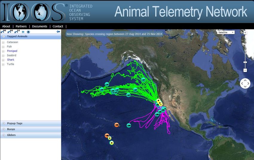
Figure 5. ATN DAC web portal graphical display that includes location data for track visualization in real‐time,
downloads of ocean profile data, and acoustic detection data. These data can be downloaded via U.S. IOOS
standard service (e.g., ERDDAP). This website is accessible at oceanview.pfeg.noaa.gov/ATN.
15You can also read