Appendix I: City of Laurel, MD Flood Hazard Addendum
←
→
Page content transcription
If your browser does not render page correctly, please read the page content below
Appendix I: City of Laurel, MD Flood Hazard Addendum

                                                       1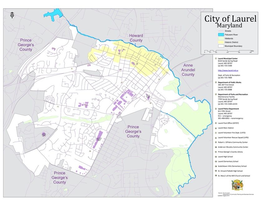
Table of Contents

   SECTION 1 EXECUTIVE SUMMARY .............................................................................................................................. 3
   1.1 ORGANIZATION OF THE PLAN ......................................................................................................................... 3
   1.2 BACKGROUND ............................................................................................................................................. 3
   1.3 HAZARD AND RISKS ...................................................................................................................................... 4
   1.4 SUMMARY OF GOALS, OBJECTIVES, STRATEGIES AND ACTIONS ............................................................................. 4
   1.5 ACTION ITEMS............................................................................................................................................. 4
   1.6 THE PLANNING PROCESS ............................................................................................................................... 5
   1.7 IMPLEMENTATION PROCESS ........................................................................................................................... 5
   1.8 MONITORING AND UPDATING PROCESSES ........................................................................................................ 5
   SECTION 2 BACKGROUND ........................................................................................................................................ 6
   2.1 INTRODUCTION ........................................................................................................................................... 6
   2.2 LOCATION .................................................................................................................................................. 7
   2.3 COMMUNITY ASSETS ................................................................................................................................... 7
   SECTION 3 PLANNING PROCESS ................................................................................................................................ 9
   3.1 DESCRIPTION OF THE PLANNING PROCESS......................................................................................................... 9
   3.2 HOW THE PUBLIC WAS INVOLVED ................................................................................................................. 11
   SECTION 4 FLOOD HAZARD IDENTIFICATION AND RISK ASSESSMENT............................................................................... 12
   4.1 DESCRIPTION OF THE FLOOD HAZARD ............................................................................................................ 12
   4.2 LOCATION AND EXTENT OF THE FLOOD HAZARD............................................................................................... 13
   4.3 SEVERITY OF THE FLOOD HAZARD.................................................................................................................. 14
   SECTION 5 FLOOD MITIGATION GOALS, OBJECTIVES, STRATEGIES AND ACTIONS .............................................................. 18
   5.1 FLOOD MITIGATION GOALS ......................................................................................................................... 18
   5.2 FLOOD MITIGATION OBJECTIVES ................................................................................................................... 18
   5.3 FLOOD MITIGATION STRATEGIES................................................................................................................... 19
   5.4 PRIORITIZED FLOOD MITIGATION ACTIONS ..................................................................................................... 20
   SECTION 6 FLOOD HAZARD ADDENDUM MONITORING, EVALUATION AND MAINTENANCE ................................................. 22
   6.1 METHOD FOR MONITORING THE FLOOD ADDENDUM ....................................................................................... 22
   6.2 METHOD AND SCHEDULE FOR EVALUATING AND UPDATING THE FLOOD ADDENDUM .............................................. 22
   6.3 CONTINUED PUBLIC INVOLVEMENT ............................................................................................................... 23
ATTACHMENTS............................................................................................................................................ 24

                                                                                                                                               2
Section 1 Executive Summary
On October 30, 2000, the President signed into law the Disaster Mitigation Act of 2000, also
known as DMA2K. Among its other features, DMA2K established a requirement that in order to
remain eligible for Federal disaster assistance and grant funds, local and State governments must
develop and adopt Hazard Mitigation Plans (HMPs). On February 26, 2002, the Federal Emergency
Management Agency published an Interim Final Rule (IFR) that set forth the guidance and
regulations under which such plans are supposed to be developed. The IFR provides detailed
descriptions of both the planning process that States and localities are required to observe, and the
contents of the plan that emerges. The Prince George’s County and & the City of Laurel Hazard
Mitigation Plan Update was approved by the State and the Federal Emergency Management Agency
(FEMA) in 2017, and subsequently adopted by the City of Laurel, MD.
Hazard mitigation is defined as any sustained action taken to reduce or eliminate the long-term
risk to life and property from hazard events. This City of Laurel, MD Flood Hazard Addendum is a
comprehensive re-evaluation of the flood hazard threat to the City of Laurel, including the hazard
profile, risk assessment, mitigation goals, strategies, and mitigation priorities.
Contact information for the City of Laurel, MD official submitting this Flood Hazard Addendum
is:
Mr. Stephen E. Allen, Sr.
City of Laurel Emergency Manager
8103 Sandy Spring Road
Laurel, Maryland 20707
Telephone: 301.725.5300 x2244
Email: sallen@laurel.md.us
1.1 Organization of the Plan
The City of Laurel, MD Flood Hazard Addendum is organized to parallel the structure provided in
the Interim Final Rule [IFR]. The Addendum has six (6) sections.
Section 1 Executive Summary
Section 2 Background
Section 3 Planning Process
Section 4 Flood Hazard Identification and Risk Assessment
Section 5 Flood Mitigation Goals, Objectives, Strategies and Actions
Section 6 Flood Hazard Addendum Monitoring, Evaluation and Maintenance
1.2 Background
Since the development of the existing Prince George’s County and City of Laurel Hazard
Mitigation Plan in 2010, the City of Laurel has become more involved regionally in the identification
and development of mitigation strategies specific to the flooding hazards within the community.
Action plans such as the Patuxent River Policy Plan adopted in 2015, have identified mitigation and
restoration strategies to assist local jurisdictions surrounding the Patuxent River to reduce flooding
risks. Though the existing plan does include a review of flood hazards within the community, the plan
3does not focus specifically on flood mitigation and resilience building strategies. Development of this
Flood Hazard Addendum to the existing plan will allow the City of Laurel to add value to the existing
plan and retain agility in addressing the mitigation needs of the community.
1.3 Hazard and Risks
1.3.1 Flood Hazard
Section 4 of this Addendum includes a detailed description of the City of Laurel’s risk from the
flood hazard, risk assessments for the City and more detailed assessments for City assets.
The flood hazard profile in Section 4 includes:
Ø Description of the Hazard
Ø Location and Extent of the Hazard
Ø Severity of the Hazard
Ø Impact on Life and Property
Ø Occurrences of the Hazard
1.3.2 Risks
Risk is a numerical calculation of potential future damages. Although all of the hazard events
identified in the Prince George’s County & the City of Laurel Hazard Mitigation Plan Update have some
potential to affect the City, flooding is a significant threat to life and property within the City of Laurel.
Section 4 includes details about calculation methodologies and results of the risk assessment.
1.4 Summary of Goals, Objectives, Strategies and Actions
Section 5 of this Plan describes the City of Laurel’s priorities for mitigation actions. This section
prioritizes the actions, describes the funding required, identifies potential sources of funding,
designates the responsible coordinating entity, gives anticipated year of completion, and analyzes
benefits. The section also includes the City’s flood hazard mitigation goals, objectives, and strategies.
1. Seek Federal and State grants to fund mitigation activities.
2. Encourage and facilitate the development or updating of General Plans, Drainage Plans, Land
and Zoning, Building Construction, and Floodplain Management Ordinances to limit
development in flood hazard areas.
1.5 Action Items
The Flood Hazard Addendum outlines the City’s current priorities for specific activities to achieve
the four goals listed above. Section 5 gives details for the City’s approach to addressing the flood
hazard profiled in Section 4 and reducing the risk to the City of Laurel.
41.6 The Planning Process
Section 3 provides details about the process that was used to develop this Flood Hazard
Addendum. The process closely followed the guidance in the FEMA “G318” planning guidance,
resulting in a five-stage process for the development of this addendum.
Step 1 Organize resources & create outreach strategy includes identification of a Flood
Prevention Planning Committee (FPPC) that was responsible for most aspects of Plan development.
This committee included stakeholders from the City of Laurel, which were informed of the planning
decisions and provided interim versions of the Plan for review and comment. The Mayor and City
Council of Laurel is the approving authority for the Addendum.
Step 2 Identify community assets, analyze hazards, and assess risks was completed by the
FPPC, and is included as Section 4 of the Plan.
Step 3 Develop a flood hazard plan is described in Section 3 (Planning Process). The section
includes details about who was involved, the processes that were used, and the products that were
developed.
Step 4 Implement the plan and monitor progress is described in the section 5, which includes
details about who is responsible for implementation of specific strategies and actions; and in Section
6, which describes long-term implementation through periodic updates and reviews.
Step 5 Create a safe and resilient community will be an ongoing effort accomplished through
the implementation of the mitigation strategies and actions discussed in Section 5 of this plan.
1.7 Implementation Process
The implementation process is described as part of the specific actions in the Mitigation Strategy
section (Section 5).
1.8 Monitoring and Updating Processes
Section 6 describes the schedule and procedures for ensuring that the Flood Hazard Addendum
stays current. The section identifies when the Addendum must be updated, who is responsible for
monitoring the Addendum, and ensuring that the update procedures are implemented. The section
also provides a combination of cyclical dates (oriented toward FEMA requirements) and triggering
events that will initiate amendments and updates to the Addendum. The City Administrator’s Office
is responsible for monitoring the Addendum and initiating the cyclical update process.
5Section 2 Background
2.1 Introduction
In 2005 Prince George’s County Department of the Environment and the Office of Homeland
Security Office of Emergency Management in partnership with the City of Laurel’s Office of
Emergency Services prepared its original Hazard Mitigation Plan (HMP) to be better equipped for
disasters before they occur. It was also developed to objectively evaluate the hazards that occur in
the County and prioritize the actions needed to provide a safe place to live. The Plan was developed
to satisfy the Disaster Mitigation Act of 2000 (DMA 2000) which required local governments to
develop a HMP that complied with specific regulations. If a Plan was not developed by the specified
deadline, local governments would no longer be eligible for future HMGP funding. The Plan was
developed and approved by the Maryland Emergency Management Agency (MEMA) and FEMA in
2005.
Updates to the 2005 Prince George’s County Hazard Mitigation Plan were made in 2010 and 2017.
The Prince George’s County and City of Laurel Hazard Mitigation Plan 2010 Update was approved by
FEMA Region III on February 8, 2012 and the Prince George's County - City of Laurel Multi-
Jurisdictional Hazard Mitigation Plan 2017 Update will include this City of Laurel, MD Flood Hazard
Addendum when submitted for review/approval by MEMA and FEMA.
What follows in Section 2 is a description of the “scope of the Flood Hazard Addendum” which
addresses why the Plan was originally prepared and is now being updated, maps of the planning area
and background about the City of Laurel.
2.1.1 Scope of the Flood Hazard Addendum
The original Prince George’s County Hazard Mitigation Plan was a concerted effort to be a useful
tool for all community stakeholders by increasing public awareness about local hazards and risks
and providing information about options and resources available to reduce those risks. Educating
the public about potential hazards will help each jurisdiction protect itself against the effects of future
hazards, and will enable informed decision-making regarding where to live, purchase property, or
locate business. The original Plan was updated in 2010 and has been utilized to better articulate
accurate needs for the community based on a process that involves all stakeholders including the
general public, government, business and industry.
The Prince George’s County and City of Laurel Hazard Mitigation Plan 2010 Update included re-
evaluating the original hazards, the risk assessment, mitigation goals, strategies, and mitigation
priorities. As part of the 2017 update process, all sections of the Plan were re-assessed to identify
changes and updates that may have occurred since the 2010 version or as a result of any disaster
declarations since that time.
Though the 2017 plan update does include a review of flood hazards within the community, the
plan does not focus specifically on flood mitigation and resilience building strategies. Development
of this Flood Hazard Addendum to the existing plan will allow the City of Laurel to add value to the
existing plan and retain agility in addressing the mitigation needs of the community.
62.2 Location
The City of Laurel is located
midway between the Baltimore
and Washington Metropolitan
Areas. As these two metropolitan
areas have continued to merge,
their impact on the City of Laurel
has dramatically increased.
Located within the northwest
corner of Prince George's County,
Laurel is also heavily impacted by
several other jurisdictions. To the
north and northeast are Howard
and Anne Arundel Counties
respectively with Montgomery
County located approximately a
mile to the west. Forming a natural
boundary to the north is the
Patuxent River, which serves as the
dividing line between the City of
Laurel and the two adjoining
counties.
2.3 Community Assets
The below community facilities/assets are vital to the continuity, sustainability, and resilience of
the City of Laurel.
City Hall Municipal Center – This facility houses the main City government offices to include the
Mayor, City Council, City Administrator, Deputy City Administrator, Emergency Manager, Budget,
Finance and Human Resource Office, Fire Marshal & Permit Services Office, Parks & Recreation Office,
Public Information & Communications Office, Economic & Community Development Office &
Information Technology Office and the U.S. Passport Office is within this facility. The City’s
Emergency Operations Center (EOC) is located within this facility and this facility serves as a backup
site for the Laurel Police Department’s dispatchers/communications operations.
Laurel Police Department – This facility houses the City’s full-service Police Department with a
wide variety of police functions, to include prisoner holding cells, dispatch communications office,
administrative offices, patrol offices, investigation offices, and special operations offices. This
building houses a conference hall which is open to the public and is used to host special events &
functions. This facility is used as a storage site for the LPD’s vehicles, trucks, & specialty vehicles used
for both normal & emergency operations. This facility houses several City COOP alternate work
locations.
Laurel Volunteer Fire Department – This facility is a two-level building with 4 drive-through
bays that houses the entire volunteer fire department for the City of Laurel. The upper level of the
building is dedicated to the operations branch of the department, while the lower level houses the
administrative branch. The facility contains offices, a gym, a kitchen, meeting rooms and bunk rooms
for male and female fire fighters.
7Laurel Volunteer Rescue Squad – This facility houses a private, nonprofit corporation that
provides medical, rescue, and fire services to the Greater Laurel area. The facility houses state of the
art heavy rescue equipment, a rescue engine, fire engine, water rescue team gear/equipment, two
rescue boats, two BLS ambulances, and support vehicles. The Laurel Volunteer Rescue Squad utilizes
this facility and the contained equipment to respond to over 7,000 calls for help annually.
Department of Public Works – This facility consists of 3 major structures that houses the City’s
full-service Public Works Department. Additionally, this site is the storage facility for all the City’s
fleet of trucks. The City’s Office of Emergency Management’s emergency response trailers are stored
at this facility. Building one houses the main full service DPW offices to include: administrative
offices, transportation offices, DPW Emergency Operations Center, vehicle maintenance & repair
operations, etc., building two is used to store equipment, materials, and supplies used by DPW to
support a wide range of both normal & emergency operations, and building three is DPW’s salt dome
that stores road salt used during winter weather emergencies and events.
Department of Parks and Recreation Operations – This facility consists of 2 major structures
that houses both the City’s full-service Parks & Recreation operations division and a garage structure
for the City’s Mobile Command Unit (MCU) and its Rehab/Canteen Vehicle. Building one houses the
main full service P&R offices to include: administrative offices, operational offices, emergency
support functions office, equipment storage for both normal & emergency operations, etc. This
building is used as one of P&R’s designated COOP sites and building two houses the City’s MCU
emergency vehicle and Rehab/Canteen emergency vehicle used for local, county and regional
emergency incidents and special events.
Laurel Armory – Anderson Murphy Community Center – This Parks & Recreation Department
facility consists of a variety of both recreational and office spaces used to support both public and
City employee recreational, health & wellness operations. This facility is used as one of the City’s
designated temporary emergency evacuation shelters during disasters or evacuation operations and
this building is used as one of the P&R’s designated COOP sites. This site is also the designated COOP
site for the City’s Emergency Relocation Group for COOP events.
Robert J. DiPietro Community Center – This Parks & Recreation Department facility consists
of a variety of both recreational and office spaces used to support both public and City employee
recreational, health & wellness operations. This facility is used as one of the City’s designated
temporary emergency evacuation shelters during disasters or evacuation operations. This building
is used as one of the Parks &Recreation’s designated COOP sites.
Public Schools – Laurel Elementary School, Scotchtown Hills Elementary School and Laurel High
School are all located within the boundaries of the City of Laurel.
8Section 3 Planning Process
The process used to develop the City of Laurel Flood Hazard Addendum was guided by a Flood
Prevention Planning Committee. The process included committee members which carried out most
of the planning duties, and a Stakeholders group, which was responsible for reviewing the document
at key points and providing feedback.
3.1 Description of the Planning Process
3.1.1 How the Plan was Prepared and Updated
Section 3 provides details about the process that was used to develop this Flood Hazard
Addendum. The process closely followed the guidance in the FEMA Local Mitigation Planning
Handbook, resulting in a five-stage process for the development of this mitigation plan update.
Step 1 Organize resources & create outreach strategy
Step 2 Identify community assets, analyze hazards, and assess risks
Step 3 Develop a flood hazard plan
Step 4 Implement the plan and monitor progress
Step 5 Create a safe and resilient community
3.1.2 Step 1 - Organize Resources
The City of Laurel used a standard organization to develop its Flood Hazard Addendum. The
organization is comprised of the following planning members and stakeholders:
Category Government -City Employees Public Representatives
1. Preventive Stephen Allen, Sr - OEM David McDonough - WSSC
2. Property Protection Russ Hamill - Chief LPD Vic Whipple
3. Natural Resources Bill Bailey - P&R Brian Coyle
Richard Blankenship -
4. Emergency Services Marty Flemion
FM&PS
5. Structural Projects Melanie Wieringa - CBO Jim Cross
6. Public Information Audrey Barnes - PIO Michael McLaughlin
7. Comprehensive Planning Christian Pully - E&CD Frank McColm
The City of Laurel Flood Hazard Addendum was funded through a grant from FEMA. In the
planning process, the City of Laurel procured the services of Rostan Solutions, LLC, a professional
planning consultant, to facilitate the process.
93.1.2.1 Flood Prevention Planning Committee Meeting Schedule
The Flood Prevention Planning Committee and the consultant hired by the City were responsible for
completing the Flood Hazard Addendum including all of its component sections. The committee met
three times during the planning process.
Committee Meeting 1 September 12, 2019
Flood Prevention Planning Committee members reviewed flood elevation GIS map data and known
flood event locations to assess the flood hazard within the City of Laurel as well as the flooding
problems that affect the City. (See Attachment 1 for completed map activity and Attachment 2 for
PowerPoint Presentation)
Committee Meeting 2 November 14, 2019
Flood Prevention Planning Committee members set goals to be achieved through flood mitigation
planning and reviewed possible mitigation activities that could be implemented in the City of Laurel
to achieve those goals. (See Attachment 3 for sign in sheet and prioritization activity and Attachment
4 for PowerPoint Presentation)
Committee Meeting 3 January 15, 2020
Flood Prevention Planning Committee members participated in a roundtable session to make
revisions and structural prioritization edits to the mitigation actions and drafted an action plan for
the City. (See Attachment 5 for sign in sheet and actions activity)
Flood Prevention Planning Committee members also had the opportunity to provide input and
feedback on the content and process of the Flood Hazard Addendum during these meetings.
3.1.3 Step 2 - Assess Flood Risks
In accordance with general mitigation planning practice, as well as the process FEMA established
in its Planning “How-To” series of guides, the risk assessment forms the basis for the Flood Hazard
Addendum by quantifying and rationalizing information about how flood hazards affect the City of
Laurel. The processes used to complete the risk assessment, and the results of these activities, are
described in detail in Sections 4 and 5 of this addendum. The assessment determined several aspects
of the risks of flood hazards faced by the City:
§ The flood hazards that are most likely to affect the City
§ How often flood hazards are expected to impact the City
§ The expected severity of the flood hazards
§ What areas of the City of Laurel are likely to be affected by flood hazards
§ How City assets, operations, people and infrastructure may be impacted by flood hazards
§ How private and commercial assets, operations, and infrastructure may be impacted by
flood hazards
§ The expected future losses if the flood risk is not mitigated
103.1.4 Step 3 - Identify and Scope Potential Flood Hazard Mitigation Projects
As part of the planning initiative potential flood hazard mitigation projects were identified and
scoped in accordance with the requirements of the program. The Flood Prevention Planning
Committee was provided a list of potential mitigation projects that were identified in the 2010
Hazard Mitigation Plan Update and reviewed those potential projects to identify activities most likely
to provide flood protection measures to the City of Laurel. These projects are included in Section 5
of this Flood Hazard Addendum.
3.1.5 Step 4 - Develop the Flood Hazard Addendum
The process employed to develop this Addendum was based on the FEMA Local Mitigation
Planning Handbook which outlines hazard mitigation planning procedures in accordance with the
Interim Final Rule section of the 44 CFR.
3.1.6 Step 5 - Implement the Plan and Monitor Progress
Once approved by FEMA and formally adopted by Prince George’s County and the City of Laurel,
this Addendum must be updated every five years in order for the County/City to maintain its
eligibility for various FEMA grant programs and funds. During this five-year period, the Addendum
is periodically reviewed to ensure compliance with FEMA and the State of Maryland requirements
for Addendum maintenance (See Section 6 – Plan Monitoring and Maintenance for more details). The
City will implement specific actions to achieve the goals and objectives described in Section 5 -
Mitigation Strategy. In addition to listing the mitigation strategies and actions the City is pursuing,
the section describes the progress the City has made towards reaching the individual goals since the
2017 Plan Update was adopted.
The City Administrator’s Office governs the City and has the final decision on what projects are
worked on, and how and when they will be accomplished. The action items fall under their
jurisdiction and they will delegate the tasks of the action items. Therefore the City Administrator will
coordinate with the Emergency Manager and Lead Manager of each mitigation item to accomplish
the goals and action items. The Lead Manager will follow any current procedures the City has while
completing the action items.
3.2 How the Public was Involved
The Flood Prevention Planning Committee met a total of three times during development of this
Flood Hazard Addendum. Following the third committee meeting, a public meeting was held to solicit
feedback from the public and allow attendees to provide comment on the flood risk and potential
flood mitigation activities included in the Flood Hazard Addendum. For this public meeting, a press
release was prepared informing the public about the Flood Hazard Addendum and urged the public
to attend this meeting. Attachment 4 includes the PowerPoint presentation that was shown to the
individuals of the public that attended the meeting. Attachment 6 includes photos and sign in sheet
from the public meeting.
Ø Public meeting 1 January 15, 2020
11Section 4 Flood Hazard Identification and Risk Assessment
This section includes a detailed description of the City of Laurel’s risk from the flood hazard, risk
assessments for the City and more detailed assessments for City assets. As part of the development
process for this addendum, the FPPC met at the onset of planning where members identified on a
map the specific areas within the City of Laurel that are vulnerable to the threat of the flood hazard
and have experienced flooding in the past. The data collected from committee members at this
meeting was incorporated into the identification and risk assessment of the flood hazard within the
City.
4.1 Description of the Flood Hazard
A major natural feature within the City is the Patuxent River, which runs along the northern City
boundary. Connected with the river are three major tributaries, Walker, Crow and Bear Branches.
Walker Branch traverses the northwest portion of the City and drains into the Patuxent River west
of Main Street. Bear Branch originates west of Sweitzer Lane and feeds into Laurel Lakes, and
eventually into Crow's Branch within the Greens of Patuxent. A large portion of those areas
immediately adjacent to the tributaries is a steep slope. Water flowing through the Patuxent River is
impounded between Brighton Dam in Montgomery County and the T. Howard Duckett Dam just west
of Interstate 95. Drinking water for the City is pumped from the Rocky Gorge Reservoir to the
Patuxent Water Filtration Plant.
A drainage basin for the area extends along a ridgeline west of the City and runs easterly to the
Patuxent River near the Baltimore-Washington Parkway. The system includes direct drainage into
the Patuxent River as well as into the three major tributaries. Natural drainage for the City is
generally poor owing in large part to the relative flatness of the topography.
In 1980 the Maryland General Assembly enacted the Patuxent River Watershed Act. The purpose
of this Act was to create a coordinated land management strategy for controlling non-point pollution
within the Patuxent River Watershed. The State and all seven counties within the watershed
subsequently adopted a policy plan.
As part of this effort, the City is a member of Prince George's County's Patuxent River Watershed
Advisory Committee. As Laurel becomes progressively more developed and as more of the ground
surface is covered with impervious materials, the amount of storm water runoff is continually
increasing. Without effective countermeasures, increased pollution to the river occurs. Consequences
of this pollution include silt build-up in riverbeds, brownish water from sediment runoff and debris
and litter being washed into the water and along the banks.
4.1.1 Summary of NFIP Participation
The National Flood Insurance Program (NFIP) enables property owners in participating
communities to purchase Federally-backed insurance for flood losses, which is designed to provide
an alternative to disaster assistance so that the high costs associated with the repair of flood
damages is reduced. As a participating community through the NFIP, the City of Laurel has adopted
and enforces local floodplain management regulations that meet or exceed the minimum Federal
NFIP floodplain management regulations. The City’s participation and utilization is further
discussed in the Prince George’s County & the City of Laurel Hazard Mitigation Plan Update Section
4.5.1, and is summarized through the three tables below:
12City of Laurel NFIP Participation
Jurisdiction Initial FHBM Initial FIRM Current
Identified Identified Effective Map
Date
City of Laurel 9 Aug 1974 1 Nov 1978 16 Sep 2016
City of Laurel NFIP Policies in Force
Jurisdiction Policies in Force Insurance In- Written
Force Whole Premium In-Force
City of Laurel 175 42,481,800 196,005
City of Laurel NFIP Claims as of December 2016
Jurisdiction Total Losses Closed Losses Open Losses CWOP Losses Total Payments
City of Laurel 17 5 0 12 $99,870.88
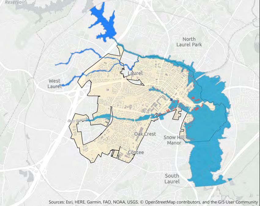
4.2 Location and Extent of the Flood Hazard
Prince George’s County is bordered by the Patuxent River to the east and the Potomac River to
the west. The City of Laurel is located in the northeast section of the County and borders the Patuxent
River. The majority of tributaries, branches, and creeks in the area flow into either of these two rivers.
The effective FEMA Flood Insurance Rate Maps (FIRM) for the City were updated September 16,
2016. They show one-percent annual chance floodplains associated with the rivers and streams in
the Potomac and Patuxent
watersheds. The FIRM
identifies high flood hazard risk
areas as part of the one-percent
annual chance (100 year)
floodplain, moderate risk areas
as part of the 0.2-percent
annual chance (500 year)
floodplain, or minimal risk
areas outside the 500-year
floodplain. Using ESRI GIS tools,
the following map was created
to show the location of
structures within the following
zones:
- 7,623 properties in X zone
- 268 in AE zone
- 5 in A zone
- 3 in AO zone
Attachment 1 details seven (7) “hot-spot” areas of flood risk identified by the FPPC.
134.3 Severity of the Flood Hazard
Flood severity is measured in several ways, including frequency, depth, velocity, and duration,
among others. For the City of Laurel, generally speaking the severity relates to how frequent floods
occur. The City of Laurel has experienced several flood events that have caused damage since the
2010 mitigation plan update was adopted. The table below summarizes several that have occurred.
Some of these flood instances are related to remnants of tropical storms and hurricanes that have
also affected many other areas of the United States.
Event Date Description
Remnants of Tropical Storm Nicole produced massive amounts of rain throughout
September 2010
Maryland.
Hurricane Irene did not make direct landfall, but due to the large size, hurricane
August 2011 conditions were felt inland. FEMA issued an Emergency declaration (FEMA-EM-
3335-MD) for the incident beginning August 26, 2011.
The remnants of Tropical Storm Lee moved across Maryland, causing widespread
flooding.7 Prince Georges County experienced around 24 inches of rainfall from
September 2011
this storm. FEMA issued a Major Disaster declaration (FEMA-DR-4038-MD) for the
incident beginning September 6, 2011.
Hurricane Sandy makes landfall north of the state. However, due to the tremendous
size of the storm, its effects were felt all over Maryland. Over a foot of rain fell in
October 2012 some spots along with very gusty winds. FEMA issued Emergency (FEMA-EM-
3349-MD) and Major Disaster (FEMA-DR-4091-MD) declarations for Sandy
beginning October 26, 2012.
Flash flooding from a severe storm caused dangerously high Patuxent River levels
April 30-May 5, 2014 and resulted in a necessary release of water from the T. Howard Duckett Dam.
Flooding impacts were noted at structures throughout the City of Laurel.
September 2015 Flash floods and riverine flooding occurred due to heavy rainfall.
While Hurricane Matthew did not make landfall in the state, the storm still brought
October 2016
rain and gusty winds to the city of Laurel due to its large size.
4.3.1 Impact on Life and Property
There have been 19 floods recorded in the City of Laurel in the period from 1996 to 2019, with 2
of those events resulting in property damages of $120,000. This count includes floods, and flash
floods.
4.3.2 Occurrences of the Flood Hazard
According to the NOAA NCEI Storm Events Database, there have been 19 reported flood events
in the City of Laurel since 1996. As demonstrated in the table below there was an average of $6,316
in damages (all property damage with no reported agricultural damage), and no deaths or injuries
reported to the database during this period.
14Current Total
Number of Period of Annualized Annualized Annualized
HIRA Hazards Annual
Events Record Deaths Injuries Events
Damages
Flash
19 1996-2019 $6,316 0 0 0.82
Flood/Flood
The table below summarizes the 19 flood events occurring in the City of Laurel in the last 23
years.
Flood Events, City of Laurel, 1996 – 2019
Location or County Date Time Type Dth Inj
Prince George’s County 8/26/1999 1700 Flash Flood 0 0
Prince George’s County 9/9/1999 2000 Heavy Rain 0 0
Prince George’s County 9/16/1999 800 Flash Flood 0 0
Prince George’s County 9/16/1999 800 Flash Flood 0 0
Prince George’s County 9/2/2000 1400 Heavy Rain 0 0
Prince George’s County 9/3/2000 1400 Heavy Rain 0 0
Prince George’s County 9/24/2000 1200 Heavy Rain 0 0
Prince George’s County 12/16/2000 2100 Heavy Rain 0 0
Prince George’s County 6/7/2001 230 Heavy Rain 0 0
Prince George’s County 6/21/2001 1630 Heavy Rain 0 0
Prince George’s County 6/7/2003 600 Heavy Rain 0 0
Prince George’s County 6/19/2003 1900 Heavy Rain 0 0
Prince George’s County 7/22/2003 1800 Heavy Rain 0 0
Prince George’s County 12/11/2003 700 Flood 0 0
Prince George’s County 7/8/2005 900 Heavy Rain 0 0
Prince George’s County 6/26/2006 1830 Flash Flood 0 0
Prince George’s County 7/6/2006 32 Flash Flood 0 0
Prince George’s County 8/12/2014 1145 Flash Flood 0 0
Prince George’s County 5/19/2015 40 Flood 0 0
4.3.3 Flood Risk Assessment
The City of Laurel’s vulnerability and risk from the flood hazard is analyzed and assessed in the
Prince George’s County & City of Laurel Hazard Mitigation Plan Update in Section 4.5.1 using the Total
Exposure in Floodplain (TEIF) Methodology. This analysis identified many areas within the City of
Laurel that may be at risk to flood and demonstrated that the City accounted for more than 12% of
the County’s property value exposure to the risk of floods.
15The FPPC, through this Flood Hazard Addendum planning process, further assessed the City’s
risk from the flood hazard by analyzing the vulnerability of critical facilities within the City of Laurel.
Of the data gathered about these facilities, the factors directly affecting the facility’s susceptibility to
damage and/or loss from flooding are the building’s construction date and flood zone. Critical
facilities constructed prior to 1976 were built before the first Flood Insurance Rate Map (pre-FIRM)
and therefore were not designed with flood protection in mind. This leaves those structures more
vulnerable to future flooding than those constructed post-FIRM which increases the risk of future
damage. The designated flood zone in which each facility lies also greatly affects the likelihood that
flooding will occur at that location. The table below summarizes the flood event vulnerability of
critical facilities in the City of Laurel, in order of greatest risk.
City of Laurel Critical Facilities
Flood Vulnerability Assessment
Year Effective Zone Pre/Post FLOOD
Name of Facility Purpose Address
Built Zone Risk Firm Risk RISK
Laurel Volunteer Rescue Squad P 14910 Bowie Rd. 1952 AE-EL 142 2 3 High
Laurel Police Department P 811 Fifth St. 1988 AE-EL 165 2 2 Moderate
City Hall Municipal Center A 8103 Sandy Spring Rd. 1945 X 1 2 Moderate
Department of Parks and Recreation
A,P 7705 Sandy Spring Rd. 1962 X 1 2 Moderate
Operations
Laurel Armory-Anderson Murphy
R 422 Montgomery St. 1927 X 1 2 Moderate
Community Center
Laurel Elementary School E 516 Montgomery St. 1973 X 1 2 Moderate
Laurel High School E 800 Cherry Ln. 1965 X 1 2 Moderate
Laurel Volunteer Fire Department P 7411 Cherry Ln. 1990 X 1 1 Low
Department of Public Works P 305-307 First St. 1988 X 1 1 Low
Robert J. DiPietro Community Center R 7901 Cypress St. 1993 X 1 1 Low
Scotchtown Hills Elementary School E 15950 Dorset Rd. 1980 X 1 1 Low
A = Administration P = Public Safety R = Recreation E = Education
The following was used to assign a level of risk to the critical facilities listed in the above table.
Zone Risk
§ 1 = Structures located in an effective “X” zone
§ 2 = Structures located in an effective “AE” zone
Pre/Post FIRM Risk
§ 1 = Structures built after 1975 and located in an effective “X” zone
§ 2 = Structures built after 1975 and located in an effective “AE” zone; or
Structures built prior to 1976 and located in an effective “X” zone
Those levels of risk were combined to assign an overall flood risk to each critical facility as
described below:
16FLOOD RISK
§ Low – These structures were built after the development of community Flood
(1 – 2) Insurance Rate Maps and were therefore designed with flood protection in
mind. They are also located in an effected “X” zone which further reduces the
likelihood of future damage/loss.
§ Moderate - These structures are at an increased level of risk due to their combined Zone
(3 – 4) and Pre/Post Firm Risk. Those built post-FIRM are located in an effective “AE”
zone which puts them at a higher risk, and those located in an effective “X”
zone were built pre-FIRM and are at an equally elevated risk.
§ High - These structures are the most vulnerable of those inventoried and carry the
(5 – 6) greatest damage/loss risk from future flood events. They are all located
within an effective “AE” zone which in itself poses a larger flood threat.
Structures given a “High” level of risk were constructed pre-FIRM and are
located in an effective “AE” zone.
Of the 11 public facilities assessed, 7 are at a Moderate to High risk to a future 100-year Flood
Event as assessed through comparison with the 2016 FIRM data and structure construction date
17Section 5 Flood Mitigation Goals, Objectives, Strategies and Actions
During the Flood Hazard Addendum planning process, the FPPC met several times to discuss the goals,
objectives, strategies, and actions that would best meet the flood planning needs of the City of Laurel.
Committee members participated in round-table discussions and table-top exercises where potential goals
were vetted, and flood mitigation actions were derived and prioritized. The goals, objectives, strategies
and actions below were all derived as a direct result of these FPPC meetings.
5.1 Flood Mitigation Goals
Goals are general descriptions of desired long-term outcomes. State and federal guidance and
regulations pertaining to mitigation planning require the development of mitigation goals to reduce or
avoid long-term vulnerabilities to identified hazards. Mitigation goals have been established by FEMA, the
State of Louisiana, Prince George’s County, and the City of Laurel.
The goals identified in the Hazard Mitigation plan are:
It is the goal of Prince George’s County and the City of Laurel, Maryland, to protect and improve the public
health, safety, and welfare of its communities, and to expand the resiliency of livable communities by:
• Increasing public awareness of natural hazards and risk reduction measures; and
• Mitigating risks due to natural hazards.
The Flood Prevention Planning Committee expanded on the overall plan goal by creating the below 4
goals specific for flood risk reduction. A list of mitigation goals at a meeting held on November 14, 2019.
The goals were determined to be those that would have the greatest benefit in flood hazard reduction to
the City of Laurel. The committee established four goals with action items listed in each goal.
1. Enhance public awareness and understanding of preparedness and risks through education and
emergency notification programs
2. Identify and pursue protective measures that will benefit the built environment and natural
systems
3. Facilitate sound development in the City through local plans and regulations to reduce or eliminate
the potential impact of flooding
4. Invest in structural and green infrastructure projects to manage future risk
5.2 Flood Mitigation Objectives
Objectives are well-defined intermediate points in the process of achieving goals. City of Laurel flood
mitigation planning objectives include:
1. Reduce the exposure of residential areas to flooding.
2. Ensure that City critical facilities remain functional during flood hazard events.
3. Find and develop opportunities to work with other agencies to leverage mitigation funds, and to
share information about the risks of flooding hazards.
4. Improve the early warning and Public Alert System for flood hazards to save lives and reduce
damages to property.
5. Promote partnerships among Federal, State, County, and City Governments to identify, prioritize
and implement flood mitigation actions.
186. Participate in the CRS program through the NFIP to allow citizens to purchase flood insurance at a
discounted price.
7. Maintain the viability of City of Laurel businesses by preventing damages from flood hazards.
8. Ensure that the City maximizes its opportunities for access to Federal and State grants and other
kinds of assistance.
9. Provide effective implementation of existing floodplain regulations and building codes.
10. Ensure that the City continues to be represented in the determination of region-wide flood
mitigation actions.
11. Stay involved with citizen and technical groups concerning measures related to flood hazard
mitigation.
5.3 Flood Mitigation Strategies
Strategies are specific course of action to achieve the objectives. City of Laurel mitigation planning
strategies include:
1. Maintain awareness of the potential effects of flood hazards on City of Laurel assets. Use new
information from flood events to increase local knowledge of risks.
2. Undertake vulnerability and risk studies to better understand the potential for future damages.
3. Ensure the City Emergency Operations Plan is maintained and updated and enhance Public Alert
System.
4. Implement cost-effective projects and actions to reduce risk from flood hazards, both for City assets
and operations, as well as for residents and businesses in the planning area.
5. Install emergency backup generators at all critical facilities.
6. Distribute information to the public concerning the hazards associated with flooding. Include with
the material opportunities about mitigation measures that can reduce flooding.
7. Monitor mitigation measures to ensure they are functioning efficiently.
8. Promote the purchase of flood insurance.
9. Continuously monitor this Flood Hazard Addendum to ensure that it remains current with regard
to risks, strategies, priorities and mitigation actions.
10. Promote public understanding, support and demand for hazard mitigation.
11. Pursue drainage projects that will reduce local flooding in the City.
12. Seek Federal and State grants to fund mitigation activities.
13. Encourage and facilitate the development or updating of General Plans, Drainage Plans, Land and
Zoning, Building Construction, and Floodplain Management Ordinances to limit development in
flood hazard areas.
195.4 Prioritized Flood Mitigation Actions
The table below outlines mitigation actions that have been identified by the FPPC. The actions are prioritized and give implementation information, including: Person/Agency responsible,
potential funding sources, and the anticipated year of completion. This information further identifies how City of Laurel could potentially implement these actions should funding become available.
Primary
Responsible Potential Anticipated
Mitigation Description Prioritization Coordinating Entity Funding Year of
Project
Agency Completion
Type
Partner with FEMA/MDE to promote the use of Updated Flood Hazard Emergency Manager; Dept FEMA; HUD;
Prevention Maps. Medium - High of Economic Development NRCS; EPA 2025
Integrate mitigation plan requirements and actions into other appropriate
Emergency Manager; Dept of FEMA; HUD;
Prevention planning mechanisms such as: comprehensive plans, capital improvement plans, Medium - High 2022
Economic Development NRCS; EPA
and master plans
Increase storm water protection management including retention and Emergency Manager; Dept of
Prevention Medium - High Local 2022
detention basins through partnership with Prince George's County Economic Development
Dept of Economic Development;
Property Implement joint inspections for projects within the City by working closely with High Local 2022
Soil Conservation District
Protection Prince George’s County soil conservation district (SCD)
Emergency Manager;
Seek mitigation solutions for city facilities, including: the flood-prone municipal Department of Economic &
Property swimming pool; Department of Public Works flood-prone buildings; and the City of High Community Development; FEMA; HUD; 2025
Protection Laurel Police Department building Department of Public Works, NRCS; EPA
Laurel Police Department,
Department of Recreation.
Support mitigation projects that will result in protection of public or
private property and historic properties/districts from natural hazards, such as:
Property acquisition of flood-prone property; elevation of flood-prone structures; minor High Emergency Manager; Dept of FEMA; HUD; 2025
Protection structural flood control projects; relocation of structures from flood prone areas; Economic Development NRCS; EPA
stormwater management improvements; and advanced warning systems and
hazard gauging systems.
Property Join the FEMA Community Rating System to reduce the cost of NFIP policy Emergency Manager; Dept
Medium - High FEMA; ISO 2021
Protection premiums of Economic Development
Property Emergency Manager; CERT
Protection Encourage the purchase of flood insurance Medium volunteers; PIO Local ongoing
20Primary
Responsible Potential Anticipated
Mitigation Description Prioritization Coordinating Funding Year of
Project Type
Entity Agency Completion
Analyze the structural integrity of dams within the City (both natural and Emergency Manager; Parks &
High Local 2025
Structural man-made), evaluate their upstream and downstream impacts, and Rec; Economic Development;
assess each for potential measures that could reduce flood risk Public Works
FEMA; HUD;
Education & Implement a flood warning system with gages that allows for
High NRCS; EPA 2025
Awareness alert/notification to those in the flood threat area Emergency Manager
Education & Hold outreach meetings to inform City residents of the plan for Emergency Manager; CERT
High Local 2021
Awareness evacuation during a flood volunteers; PIO
Education & Educate public on the negative effects of dumping waste and not cleaning catch Emergency Manager; CERT
High-Medium Local 2022
Awareness basins, and enforce penalties for violations volunteers; PIO
Education & Continue outreach efforts to promote recently completed bi-lingual Citizens Emergency Manager; CERT FEMA; HUD;
High-Medium 2022
Awareness Emergency Preparedness Guide volunteers; PIO Local
Education & Provide preparedness education to residents in flood-prone areas, Emergency Manager; CERT FEMA; HUD;
High-Medium 2022
Awareness including tenants occupying rental property volunteers; PIO Local
Education & Continue to build, improve, and maintain a phone/text/ e-mail/social media Emergency Manager; CERT FEMA; HUD;
Medium 2023
Awareness emergency notification warning system volunteers; PIO Local
Education & Establish an education and outreach program to children/youth within Emergency Manager; CERT FEMA; HUD;
Medium 2023
Awareness schools, libraries, and other community avenues volunteers; PIO Local
Emergency FEMA; HUD;
Services Develop and implement a flood evacuation plan High Emergency Manager Local 2021
Test and exercise the new notification procedures within the City of
Emergency Laurel and Prince George’s County to identify any shortfalls or procedures that High Emergency Manager Local 2021
Services need to be amended - expanded floodplain areas must be addressed in
relationship to areas affected by a release of water from
21Primary
Responsible Potential Anticipated
Mitigation Description Prioritization Coordinating Entity Funding Year of
Project Type
Agency Completion
Emergency Provide flood response training to emergency personnel and include response High-Medium Emergency Manager FEMA; Local 2022
Services agencies across City boundaries for continuity of operations
Emergency Hold periodic drills/exercises for flash flood response, nuisance flooding, and
Services dam failure – include response agencies across City boundaries for High-Medium Emergency Manager 2022
FEMA; Local
continuity of operations
Emergency Purchase specialized equipment for flood rescue and response, including that High-Medium Emergency Manager FEMA; HUD; 2022
Services which is needed for swift-water rescue
Local
Natural Implement protection measures that extend across City boundaries including Emergency Manager; Parks
FEMA; HUD;
Resources retention and detention basins High & Rec; Economic Development; 2024
Protection Public Works County; Local
Natural Emergency Manager; Parks &
FEMA; HUD;
Resources River/Stream/Bank Restoration High Rec; Economic 2025
County; Local
Protection Development; Public Works
Natural Emergency Manager; Parks & Rec;
Implement green infrastructure mechanisms to improve water quality, High-Medium FEMA; HUD; 2025
Resources Economic Development; Public
increase canopy coverage, and aid in erosion prevention County; Local
Protection Works
Natural Emergency Manager; Parks
FEMA; HUD;
Resources Enhance and enforce wetland preservation and restoration High-Medium & Rec; Economic Development; 2024
Protection Public Works County; Local
Natural Emergency Manager; Parks FEMA; HUD;
Resources Develop a comprehensive watershed management plan and program Medium - High & Rec; Economic Development; Silver Jackets; 2024
Protection Public Works Local
Natural Emergency Manager; Parks
Resources Implement an Adopt-A-Stream program Medium & Rec; Economic Development; Local 2025
Protection Public Works
22Section 6 Flood Hazard Addendum Monitoring, Evaluation and Maintenance
6.1 Method for Monitoring the Flood Addendum
This Plan will be monitored by the City of Laurel Administrator’s Office for several related purposes:
1. Maintain the currency of flood hazard and risk information.
2. Ensure that flood mitigation projects and actions reflect the priorities of the City of Laurel and the
Flood Prevention Planning Committee.
3. To comply with FEMA and State of Maryland requirements for plan maintenance, and maintain the
City of Laurel’s eligibility for federal disaster assistance and mitigation grants.
Through the flood mitigation planning process, the FPPC considered a range of flood mitigation actions.
These actions were identified and prioritized and are shown in Section 5. Each action is assigned a lead
agency; each agency is responsible for factoring the action into its work plan and schedule over the
indicated time period.
6.2 Method and Schedule for Evaluating and Updating the Flood Addendum
The City of Laurel Administrator’s Office will coordinate an annual meeting of the Flood Prevention
Planning Committee and assemble an annual report to the Maryland Emergency Management Agency and
FEMA Region III detailing annual progress on mitigation actions as well as outreach activities.
The City Administrator’s Office will compile an annual report to document progress on the mitigation
actions. To monitor progress, a meeting may be convened of the lead agencies to discuss and determine
progress, and to identify obstacles to progress, if any. Should the City determine during this annual process
that the FPPC should be reconvened for discussion, the following criteria would be used to make that
determination:
• Are there any changes in mitigation plan requirements for funding programs?
• Are any changes or revisions required to the Mitigation Action Items? (i.e. Have any action
items been completed? Have any new specific flood mitigation action items been identified?)
• Does a review of the annual report indicate any changes are necessary?
• Are there any changes within the Flood Prevention Planning Committee?
In addition to the scheduled reports, comprehensive review and revisions to this Flood Hazard
Addendum will be undertaken on the required five-year cycle. The Prince George’s County & the City of
Laurel Hazard Mitigation Plan Update was approved by FEMA in 2017, and thus must undergo a formal
FEMA-complaint update by 2022. If a disaster occurs, or as action items are completed, the Addendum
may be reviewed, revised, and updated sooner than the required five years.
The FPPC will be reconvened approximately one year before the five-year deadline described above
and begin evaluating the Flood Hazard Addendum. The above criteria and the key topics and questions
below will be addressed at the meeting:
• Has a flood event occurred since the last plan update?
• Are additional flood maps or new flood studies available?
• Has the probability of future flood events changed?
• Have recent and future developments in the City been checked for their effect on the flood
hazard area?
• Have inventories of existing structures in hazard areas been updated?
23You can also read