Aspendale to Bonbeach - Local Flood Guide - For flood emergency assistance call VICSES on 132 500 - Victoria State Emergency Service
←
→
Page content transcription
If your browser does not render page correctly, please read the page content below
Aspendale to Bonbeach
                          Local Flood Guide

For flood emergency assistance call
VICSES on 132 500

The Victoria State Emergency Service respectfully acknowledges Aboriginal and
Torres Strait Islander people as the Traditional owners of the land throughout Victoria   Reviewed: February 2021
and acknowledges their ancestors and elders, past, present and emerging.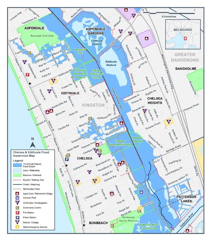
Local Flood Guide Aspendale to Bonbeach
Your Local Area
This area is prone to flash flooding during heavy rainfall events that can result in road closures and effect
private properties. This guide provides an overview of the risk of flood and includes information that can help
you to be more prepared in case of an emergency.
This guide focusses on the coastal suburbs of Aspendale, Edithvale, Chelsea and Bonbeach that are located
within the City of Kingston, approximately 30 kilometres south-east from Melbourne’s Central Business
District.
It is predominantly a residential area, which also includes several schools, shops and recreational facilities.
East of the Frankston railway line, these suburbs drain inland towards Melbourne Water’s drainage system
known as the ‘Centre Swamp Drainage Reserve’ where the Longbeach Trail is located. Stormwater from the
areas north of Thames Promenade, flow towards Mordialloc Creek, whilst the southern area flows towards
Patterson River.
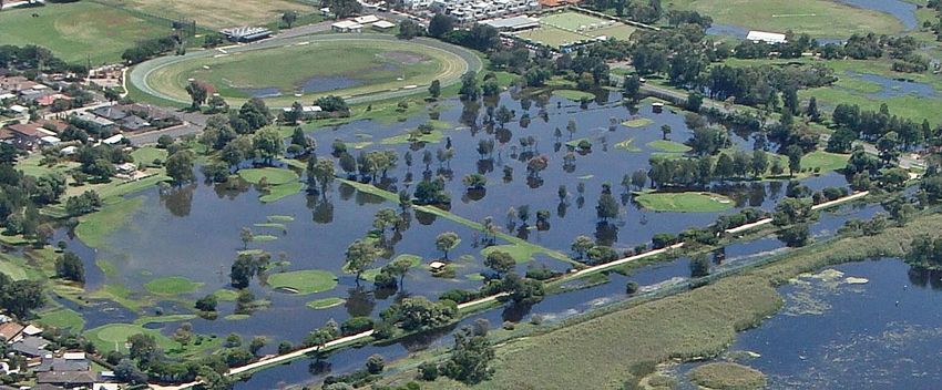
The map below provides an indication of flooding that could occur during an extreme 1% flood event, formerly
referred to as a 1 in 100 year rainfall event. A 1% flood means there is a 1% chance a flood this size
happening in any given year. This map is provided as a guide to possible flooding in the area.
This map is consistent with the extents of flooding documented within the current planning
scheme and is subject to change should new information become available.
Disclaimer
This map publication is presented by Victoria State Emergency Service for the purpose of disseminating emergency management
information. The contents of the information have not been independently verified by Victoria State Emergency Service. No liability is
accepted for any damage, loss or injury caused by errors or omissions in this information or for any action taken by any person in reliance
upon it. Flood information is provided by Melbourne Water.
Reviewed: February 2021 2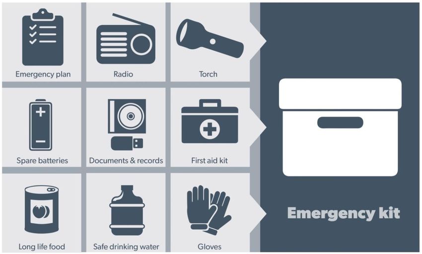
Local Flood Guide            Aspendale to Bonbeach

Are you prepared for a flood?
This guide contains important information on the key agencies that can provide assistance, where to find flood
warning and storm information, helpful websites and practical information on how you can be better prepared.

Experience shows that those who plan and prepare for emergencies can reduce the impact of the emergency
and can recover quicker afterwards.

Further information on ‘Preparing for Flood Emergencies’ is also available at ses.vic.gov.au/get-ready

Are you at risk of flood?
Most areas of Melbourne experience some level of flooding during an extreme storm event, with
those developed prior to the 1970’s generally being more likely.

Within the City of Kingston, around 20% of all properties within the municipality have some level
of flood risk during heavy rainfall.

Whilst all Aspendale to Bonbeach residents can expect to experience some localised flooding, the lower lying
areas that are located further away from the coast are more likely to experience more significant levels of
flooding. Properties that are more likely to have a lower risk of flood include those that are closer to the railway
line and the newer suburbs including Aspendale Gardens and Patterson Lakes,

The most recent extreme storm event, causing havoc across most Melbourne suburbs, occurred in February
2011. Within your suburb, most local roads were flooded at the low points to a depth of between 100
millimetres to 500 millimetres. Edithvale Road was severely impacted and was closed for a period of 8 days.

Road closures present a risk for emergency services and evacuations for people living in locations that have
limited access, routes that include Nepean Highway to the north and south, and Edithvale Road and Thames
Promenade to the east.

Whilst authorities will continue to invest in drainage maintenance and improvements, these works are
focussed on reducing the impacts of small to medium intensity rainfall events. Due to the way that the
subdivisions were developed in this area prior to the 1970’s, it is simply not possible to fully address the extent
of flooding during extreme rainfall events.

Did you know?
Edithvale Road passes through a world registered
wetland that was once part of a much larger                              No two floods are the same. Floods
wetland and swamp system that extended from                              like this or worse could occur again.
Mordialloc to Frankston!
                                                            If you live in a low-lying area you may be at risk of
Historically, several major floods have affected            flooding or need to detour around flooded areas.
people living in this area, such as:
                                                            Knowing what to do can save your life and help
                                                            protect your property
•    In December 1934, Chelsea and surrounding
     areas were severely flooded, and some 1500
     people were evacuated from their homes.
•   In July 1952, some 1200 people were
    evacuated from their homes in the bayside suburbs of Chelsea, Bonbeach, Seaford and Carrum because
    of severe flooding. During the 1950s and 1960s, the installation of floodgates and pumps on the
    Patterson River, and the raising of the height of levee banks, increased protection of Chelsea and
    surrounding areas from severe flooding. However, flooding still occurs in Kingston’s suburbs.

•    In November 2003, thunderstorms resulted in localised flash flooding across the Melbourne metropolitan
     area including at Chelsea.

Reviewed: February 2021                                                                                             3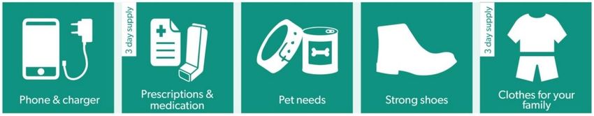
Local Flood Guide           Aspendale to Bonbeach

•    In February 2011, there was an extreme flood event. The worst affected area was a 10 kilometre wide
     band through Beaconsfield and Dandenong South that received 180mm of rain in one hour, equivalent to
     a 1 in 500 year event. The central part of the City of Kingston experienced up to 150mm/hr or equivalent
     to a 1 in 100 year storm event.

•    In March 2020, an intersection in Chelsea was underwater and a driver had to be rescued by the
     Chelsea SES Unit.

If you require assistance during a flood or storm, contact SES on 132 500. Your local SES Chelsea Unit will
be able to assist you.

 Staying Informed and Further Information
 ◼   Current warnings (VicEmergency)         emergency.vic.gov.au                      1800 226 226
 ◼   Bureau of Meteorology (BoM)             bom.gov.au/vic/warnings                   1300 659 217
 ◼   VicRoads Traffic                        traffic.vicroads.vic.gov.au
 ◼   Emergency Broadcasters                  ABC 774 AM                                  Life-threatening
                                             SKY NEWS Television                            Emergency
                                             3AW 693 AM                                         000
 ◼   VICSES Social Media                     facebook.com/vicses
                                             twitter.com/vicsesnews
                                             https://www.facebook.com/ChelseaSES
 ◼   Preparing for Flood Emergencies         ses.vic.gov.au/get-ready
 ◼   Creating an Emergency Plan              redcross.org.au/prepare
 ◼   Melbourne Water                         melbournewater.com                        131 772
 ◼   City of Kingston                        kingston.vic.gov.au                       1300 653 356
 ◼   National Relay Service (NRS)            relayservice.gov.au

Reviewed: February 2021                                                                                       4
Local Flood Guide            Aspendale to Bonbeach
                   Flood warnings and
                   emergency checklist
Bureau of Meteorology Warnings
Warnings are issued by the Bureau of Meteorology (BoM) to tell people about possible flooding.

A Flood Watch means there is a developing weather pattern that might cause floods in one or two days. This
service covers the whole state.

A Flood Warning means flooding is about to happen or is already happening. There are minor, moderate and
major flood warnings. This service is only available where flood warning systems are in place.

      A Minor Flood Warning                 A Moderate Flood                     A Major Flood Warning
      means floodwater can:                 Warning means                        means floodwater can:
                                            floodwater can:
 Spill over river banks and cover     Spill over river banks and cover     Cause widespread flooding.
 nearby low lying areas.              larger areas of land.
 Come up through drains in            Reach above floor levels in some     Many houses and businesses are
 nearby streets.                      houses and buildings.                inundated above floor level.
 Require the removal of stock in      Require evacuation in some           Cause properties and whole
 some cases.                          areas.                               areas to be isolated by water.
 Cover riverside camping areas        Affect traffic routes.               Closes major roads and rail
 and affect some low-lying                                                 routes.
 caravan parks.
 Cover minor roads paths, tracks      Require the removal of stock in      Require many evacuations.
 and low level bridges.               rural areas.
 Affect backyards and buildings                                            Affect utility services (power,
 below floor level.                                                        water, sewage etc).

Severe Thunderstorm Warnings
Thunderstorms are classified as severe when there is potential to cause significant localised damage through
wind gusts, large hail, tornadoes or flash flooding. Severe Thunderstorm Warnings are issued to the
community by BoM.

Severe Weather Warnings
These warnings are issued to the community by BoM when severe weather is expected that is not directly
related to severe thunderstorms or bushfires. Examples of severe weather include damaging winds and flash
flooding.

Flash Flooding
◼   Flash Flooding can occur quickly due to heavy rainfall. You may not receive an official warning.
◼   Stay informed- monitor weather warnings, forecasts and river levels at the BoM website and warnings
    through VicEmergency.

Reviewed: February 2021                                                                                        5
Local Flood Guide            Aspendale to Bonbeach

VICSES Warnings
VICSES utilises the VicEmergency app, website and hotline to distribute flood warnings and emergency
information in Victoria. Communities can also access this information through VICSES social media channels
and emergency broadcasters.

VICSES warnings aim to provide you with information to help you make good decisions to protect yourself and
your family

The warning level is based on severity, conditions and the likelihood that the emergency could impact on the
community.

 WARNING LEVELS

                    EMERGENCY WARNING
                    You are in imminent danger and need to take action immediately. You will be impacted. A
                    Major flood warning usually fits into this category

                    WARNING (WATCH AND ACT)
                    An emergency is developing nearby. You need to take action now to protect yourself and
                    others. A Moderate flood warning usually fits into this category.

                    ADVICE
                    An incident is occurring or has occurred in the area. Access information and monitor
                    conditions.
                    Can also be used as a notification that activity in the area has subsided and is no longer
                    a danger to you. A Minor flood warning or Flood Watch usually fits into this category.

 ADDITIONAL MESSAGES

                    PREPARE TO EVACUATE/ EVACUATE NOW
                    An evacuation is recommended or procedures are in place to evacuate.

                    COMMUNITY INFORMATION
                    A newsletter containing updates for communities affected by an emergency.
                    Can also be used as a notification that an incident has occurred but there is no threat to
                    community.

                    EMERGENCY ALERT
                    During some emergencies, we may alert communities by sounding a local siren, or by
                    sending an SMS to mobile phones or a voice message to landlines.

Your emergency plan
Emergencies can happen at any time and with little warning. People who plan and prepare for emergencies
can reduce the impact and recover faster.

Taking the time to think about emergencies and make your own plan helps you think clearly, have more
control and make better decisions when an emergency occurs.

Visit redcross.org.au/prepare start creating your plan.

 ◼   Remember, you may not receive any official warning.
 ◼   Emergency assistance may not be immediately available.
     Be aware of what is happening around you to stay safe.
 ◼   Never wait for a warning to act.

Reviewed: February 2021                                                                                          6
Local Flood Guide Aspendale to Bonbeach Emergency Kit Visit Emergency Toolkit for more information Every home and business should have a basic emergency kit with supplies for 3 days: Check your kit often. Make sure things work. Replace out of date items. When a warning is issued, have ready for use or pack into your kit: I need to add: Write your list here. Tick items as you pack them into your kit. Special needs (eg, babies, elderly and people with a disability) Photos Family keepsakes Valuables Other Reviewed: February 2021 7
Local Flood Guide Aspendale to Bonbeach Emergency Checklist Check if your insurance policy covers flooding. Keep this list of emergency numbers in your mobile phone. Download the Vic Emergency app on your mobile phone. Put together an emergency kit and prepare a home or business. Emergency plan, see https://www.redcross.org.au/prepare Before Flooding Leaving early before flooding occurs is always the safest option. Evacuating through floodwater is very dangerous and you may be swept away. Stay informed- monitor weather warnings, forecasts and river levels at the http://www.bom.gov.au and warnings through www.emergency.vic.gov.au Secure objects likely to float and cause damage. Listen to the radio and check the VICSES website for information and advice. Go over your emergency plan. Pack clothing and other extra items into your emergency kit and take this with you if you evacuate. During Flooding Make sure your family members and neighbours are aware of what is happening. Conditions change rapidly; roads and escape routes can be covered or blocked. Put household valuables and electrical items as high as possible. Turn off water, gas and electricity at the mains. If you are staying in a caravan, move to higher ground before flooding begins. Seek shelter indoors, away from floodwater. If floodwater comes inside, move to a higher point such as a kitchen bench or second storey. Stay away from trees, drains, low-lying areas, creeks, canals, culverts and floodwater. Evacuating in Flooding Flood water is dangerous. Never enter floodwater. It can take just 15cm of water to float a car. Find alternative travel routes if roads or underpasses are flooded. Be aware of driving hazards, such as mud, debris, damaged roads and fallen trees. If driving conditions are dangerous, safely pull over away from trees, drains and floodwater. After Flooding For recovery information, contact your local council, go to the VicEmergency Relief and Recovery- emergency.vic.gov.au/Relief page or call the VicEmergency Hotline (1800 226 226). Have all electrical and gas equipment professionally tested before use. Stay away from damaged and flooded buildings, fallen trees and powerlines and damaged roads until authorities advise it is safe to do so. Drive slowly, obey all road signs and never drive through floodwater. When cleaning, protect your health and safety. Wear strong boots, gloves and protective clothing and wash your hands and clothes regularly. For VICSES emergency assistance, call 132 500, or Triple Zero (000) in life threatening emergencies. Reviewed: February 2021 8
You can also read