Assessment of urban tree canopy damage in incorporated communities resulting from the August 2020 Midwest Derecho
←
→
Page content transcription
If your browser does not render page correctly, please read the page content below

Assessment of urban tree canopy damage in
    incorporated communities resulting from the August
                  2020 Midwest Derecho
Nick McGrath; Iowa Department of Natural Resources and Trees Forever

Summary of urban forest damage in incorporated communities resulting from a single derecho wind event.

INTRODUCTION
Derechos are commonplace in the eastern half of the contiguous United States with some locations experiencing up to
two per year (Figure 1). In order to be classified as a derecho a storm must have consistent straight-line winds at speeds
of 58 mph or greater, and wind damage which extends for at least 250 miles. Downbursts, or stronger winds within the
storm path, can be clocked at upwards of 90 mph. The destructive potential of derechos is also due to the high speeds of
the parent system. Often these storm systems move at speeds upwards of 50 mph, offering little to no warning for those
in its path (Corfidi et. al. 2018).

                Figure 1. Odds of the occurrence of derechos in the U.S. Data source: National Weather Service

“On August 10th and 11th, 2020 a derecho - a widespread, long-lived, straight-line windstorm - struck the State of Iowa
and surrounding states delivering catastrophic damage to structures, crops, and trees” (Goff et. al. 2021). Sustained
winds of 70 miles per hour (mph) lasted nearly an hour over a large swath of central and eastern Iowa, and wind gusts of
110 to 140 mph impacted portions of five Iowa counties (Figure 2).
Figure 2. Estimated peak wind gusts of the Midwest Derecho, August 10-11, 2020. Iowa, USA. Data source: NOAA Storm
                                              Prediction Center (Goff et al.2021).

The swath of damage resulting from this line of storms extended over 770 miles over several state lines. This system also
spawned twenty five tornados across Iowa, Illinois and Indiana (Figure 3).

Figure 3. August 10, 2020 Derecho: Lowest Angle NWS Radar Reflectivity at One Hour Time Steps. Data Source: National Weather
                                                     Service Chicago.

“The strongest estimated wind speeds in the vicinity of Cedar Rapids, Iowa, were among the highest wind speeds ever
recorded during a derecho event, peaking at about 140 mph. Estimates indicate that this is the costliest thunderstorm
event in recorded history in the United States” (NOAA). The severity and scope of damage crippled the Iowa
communities within the storm path and necessitated a significant response from government at all levels.

DEFINITIONS
“Urban tree canopy, defined as the layer of tree leaves, branches and stems in a community that cover the ground when
viewed from above, is a simple way for a community to get an overall picture of both private and public trees” (Iowa
DNR). This definition does not include grassland. All estimates reported here are for canopy of any type within
incorporated communities.

For the purposes of this report “damaged” is defined as injured but able to survive either on its own or with pruning.
“Destroyed” is defined as having sustained extensive canopy and/or stem damage necessitating removal or already on
the ground.

METHODS
Acquiring the data in this report was made possible by a request to the USFS who assisted with an aerial flight of the
impacted area. Iowa Derecho Damage Survey (IDDS) data, collected by Iowa DNR with the assistance of the Maryland
Department of Agriculture, was collected September 21-24 with assistance from the USFS (Figure 4 through Figure 6).
The percentage of acres damaged was assessed with Iowa Derecho Damage Survey (IDDS) data based on visible damage
and destruction from the air along the designated flight path. In instances where multiple severity categories of damage
were recorded, an averaged midpoint was applied when estimating damage and loss totals for that community. The
damage estimates for communities evaluated through aerial inspection were compiled for each county to establish a
baseline county average damage percentage.

The aerial flight of the Iowa Derecho Damage Survey was able to directly assess damage in 74 incorporated
communities. Due to restrictions in the aerial flight of the Iowa Derecho Damage Survey it was not possible to survey all
communities impacted by the derecho wind event. When possible, a baseline average damage percentage was
established for each county using data collected from surveyed communities. That average, respectively, was applied to
all communities within the county which were not directly surveyed. In counties where no communities were directly
surveyed no baseline county average was established and no damage estimates were suggested.

The Iowa Derecho Damage Survey damage was applied to canopy cover data for total acres of damage. Urban canopy
cover for Iowa communities was assessed using a high-resolution land cover dataset, target year 2009, (2009 High
Resolution Land Cover Web Service) in conjunction with the incorporated boundaries from the 2010 census data (U.S.
Census Bureau). An average of 135 trees per acre was assumed, using the nearest studied Midwest City, Chicago (Nowak
& Greenfield 2018, US Urban Forest Statistics, Values, and Projections; Journal of Forestry, 171-172).

RESULTS
It is estimated that the derecho wind event damaged 32,773 acres of urban canopy across Iowa based on the methods
listed above. The number of individual trees damaged or destroyed is estimated to be 4,424,426. This estimate was
obtained using Chicago averages of i-Tree data of 135 trees per acre and tree cover averaging 35.8% (Nowak &
Greenfield, 2018).

An estimate of some benefits lost due to the August 10, 2020 derecho wind event was calculated based on statewide
data regarding urban forest structural characteristics (Nowak & Greenfield, 2018. 173-176). Assuming an urban canopy
of 34,300,000 trees statewide, a total damaged estimate of 4,424,426 trees equates to 12.9% of the total canopy. This
percentage was applied to all known structural characteristics and values to determine the annual loss of benefits as
well as the immediate loss of long-term carbon storage. It is estimated the total impact for both sequestration and
storage is $20,238,846.62 per year (Table 1). The standard error of these calculations is unknown.

  Table 1. Estimated structural value and benefit loss in Iowa due to the derecho wind event on August 10, 2020. Data source:
                                                   Nowack & Greenfield, 2018.

                                                              Structural Loss
                                   Trees                  Leaf Area    Leaf Biomass           Carbon Storage
                    # of trees      Trees Per Capita       Acres            Tons            Tons             $
                   4,424,426               17.60          103,193         35,343.81      735,254.47     90,294,408.12

                                                           Annual Benefit Loss
                                                                            Air Pollution     Avoided
               Carbon Sequestration                Avoided Emissions                                             Total
                                                                              Removal        Energy Use
              Tons/Year          $/Year       Tons/Year       $/Year            $/Year         $/Year            $/Year
              22,870.28   2,966,816.12         335.38      2,708,832.24     7,713,722.29    6,849,475.82     20,238,846.62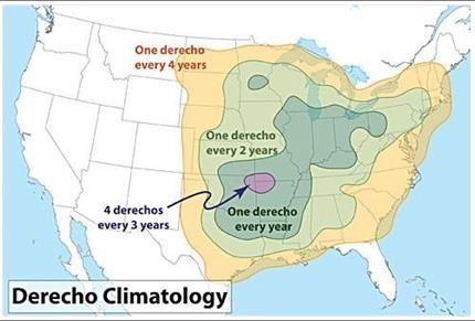
DISCUSSION
Although it would be feasible to rely on city data (e.g. inventories, FEMA reporting, etc.) to produce a smaller scale
damage report on public trees, this report presents a statewide assessment of the swath of damage that occurred within
Iowa urban areas as a result of the August 10, 2020, derecho wind event. Midpoints and averages were used for the best
estimates.

The lowest estimated percentage of urban canopy damage in a community was 7%. No communities were assessed
greater than 50% due to limitations in data collection. The flight path was structured to document the most severely
damaged locations therefore county averages may not be a reflective sample (Figure 3).

With the understanding that not all incorporated communities within a given county were affected to the same degree
and that unincorporated communities were not surveyed, the damage in estimated tree losses is grouped by county
(Table 2). This report is a snapshot of trees exhibiting signs of damage or mortality at the time of the aerial survey. It
does not account for future mortality due to tree injury, increases in pests and disease, or dieback exhibited after the
Spring of 2021. Those factors were not included in the interest of producing this report as expediently as possible.

CITATIONS
“2009 High Resolution Land Cover Web Service.” https://geodata.iowa.gov/maps/iowadnr::2009-high-resolution-land-
    cover-web-service/explore?location=41.940657%2C-93.378650%2C7.52
Corfidi, Stephen F., Jeffry S. Evans, and Robert H. Johns. “About Derechos.” May 15, 2018.
    https://www.spc.noaa.gov/misc/AbtDerechos/derechofacts.htm#definition
Goff, Thomas C; Nelson, Mark D; Liknes, Greg C; Feeley, Tivon E; Pugh, Scott A; Morin, Randall S. 2021. Rapid Assessment
    of Tree Damage Resulting from a 2020 Windstorm in Iowa, USA. Forests. 12(5): 555-.
    https://doi.org/10.3390/f12050555
“Iowa DNR Aerial Survey Maps 2020.”
    https://iowadnr.maps.arcgis.com/apps/webappviewer/index.html?id=9d901351b2e04bf680a9f4d79ba64d0d
Iowa Department of Natural Resources. “Canopy Cover”.
    https://www.iowadnr.gov/Portals/idnr/uploads/forestry/urban/canopycover.pdf
National Oceanic and Atmospheric Administration. “National Climate Report: August 2020.”
    https://www.ncdc.noaa.gov/sotc/national/202008
National Weather Service Chicago. “August 10, 2020 Derecho: Lowest Angle NWS Radar Reflectivity at One- Hour Time
    Steps.” August 11, 2020. https://www.weather.gov/dmx/2020derecho
Nowak & Greenfield (2018). US Urban Forest Statistics, Values, and Projections; Journal of Forestry, 171-176.
U.S. Census Bureau. “Iowa: 2010, Population and Housing Unit Counts”. Issued August 2012.
    https://www2.census.gov/library/publications/decennial/2010/cph-2/cph-2-17.pdf
National Weather Service. “Where and When do Derechos Occur?” https://www.weather.gov/jetstream/derecho_climo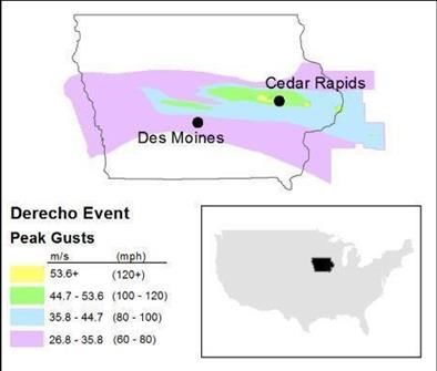
APPENDIX

                       Figure 4. Iowa DNR Aerial Survey Map, 2020 Derecho Forest Health Monitoring.

 Figure 5. Damage assessment along the USFS flight path of derecho impacted areas of Iowa, collected September 21-24, 2020.
Figure 6. Summary of the USFS flight path over the derecho impacted areas of Iowa, collected September 21-24, 2020.
Table 2. Summary of damage for derecho affected counties in Iowa derived from USFS aerial flight assessment.
                                                    Estimated acres of Estimated number of
                                       County
                                                     canopy damaged          trees damaged
                                    Total                 32,773                4,424,426
                                               Benton                          548                           74,125
                                               Boone                           805                          108,702
                                               Cedar                           272                           36,664
                                               Clinton                        2,580                         348,344
                                               Dallas                         3,204                         432,488
                                               Greene                          271                           36,649
                                               Grundy                          185                           24,973
                                               Guthrie                         247                           33,369
                                               Hardin                          656                           88,573
                                               Iowa                            113                           15,255
                                               Jackson                          82                           11,045
                                               Japser                         1,004                         135,519
                                               Johnson                        1,738                         234,567
                                               Jones                           640                           86,432
                                               Linn                           7,061                         953,224
                                               Marshall                       1,037                         140,039
                                               Muscatine                       550                           74,192
                                               Polk                           4,758                         642,348
                                               Poweshiek                       413                           55,752
                                               Scott                          3,809                         514,163
                                               Story                          1,869                         252,292
                                               Tama                            675                           91,173
                                               Washington                      256                           34,538

Federal law prohibits employment discrimination on the basis of race, color, age, religion, national origin, sex or disability. State law prohibits employment
discrimination on the basis of race, color, creed, age, sex, sexual orientation, gender identity, national origin, religion, pregnancy, or disability. State law also prohibits
public accommodation (such as access to services or physical facilities) discrimination on the basis of race, color, creed, religion, sex, sexual orientation, gender
identity, religion, national origin, or disability. If you believe you have been discriminated against in any program, activity or facility as described above, or if you
desire further information, please contact the Iowa Civil Rights Commission, 1-800-457-4416, or write to the Iowa Department of Natural Resources, Wallace State
Office Bldg., 502 E 9th St, Des Moines IA 50319.

If you need accommodations because of disability to access the services of this Agency, please contact the DNR Director at 515-725-8200. The State of Iowa is an
Equal Opportunity Employer and provider of ADA services.
You can also read