Atlanta BeltLine Redevelopment Plan - NOVEMBER 2005
←
→
Page content transcription
If your browser does not render page correctly, please read the page content below
Atlanta BeltLine Redevelopment Plan
PREPARED FOR

The Atlanta Development Authority

                                    NOVEMBER 2005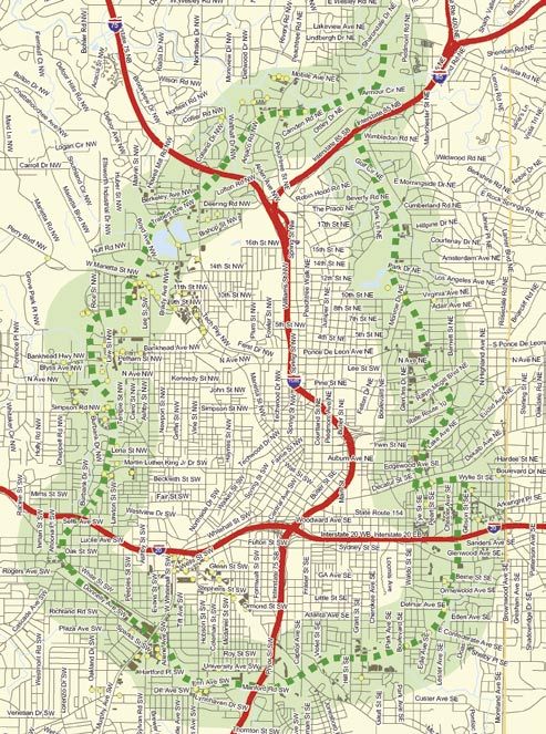
EDAW

Urban Collage

Grice & Associates

Huntley Partners

Troutman Sanders LLP

Gravel, Inc.

Watercolors: Rebekah Adkins, Savannah College of Art and Design
Acknowledgements

The Honorable Mayor                    City of Atlanta                          The BeltLine Partnership
Shirley C. Franklin, City of Atlanta
                                       Fulton County                            The BeltLine Tax Allocation District
Lisa Borders, President,                                                        Feasibility Study Steering Commi�ee
Atlanta City Council                   Atlanta Public Schools
                                                                                The Trust for Public Land
Atlanta City Council Members:          Atlanta Planning Advisory Board (APAB)
                                                                                The PATH Foundation
Carla Smith (District 1)               Neighborhood Planning Units (NPU)
                                                                                Friends of the BeltLine
Debi Starnes (District 2)
                                                                                MARTA
Ivory Young Jr. (District 3)
                                                                                Atlanta Regional Commission
Cleta Winslow (District 4)
                                                                                BeltLine Transit Panel
Natalyn Archibong (District 5)

Anne Fauver (District 6)

Howard Shook (District 7)

Clair Muller (District 8)

Felicia Moore (District 9)

C. T. Martin (District 10)

Jim Maddox (District 11)

Joyce Sheperd (District 12)

Ceasar Mitchell (Post 1)

Mary Norwood (Post 2)

H. Lamar Willis (Post 3)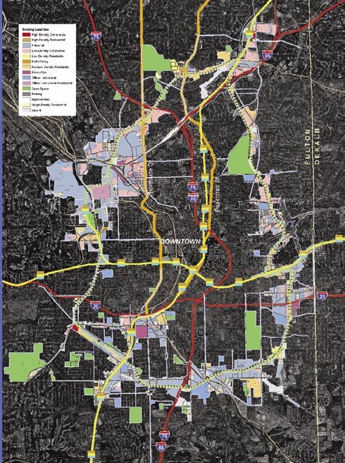
Contents

1.0 Summary                                      1   7.0 Types of Costs Covered by TAD Funding
2.0 Introduction                                 5       and Estimated TAD Bond Issuances               77
    2.1 The BeltLine Concept                     5          7.0.1 Workforce Housing                     78
    2.2 Growth and Development Context           5          7.0.2 Land Acquisition–Right-of-Way,
    2.3 Historic Development                     7                Greenspace                            78
    2.4 Feasibility Study Findings               8          7.0.3 Greenway Design and Construction      78
    2.5 Cooperating Partners                     9          7.0.4 Park Design and Construction          78
3.0 Outline of Redevelopment Plan                           7.0.5 Transit Design and Construction       78
    Requirements                                11          7.0.6 Pedestrian Improvements               78
    3.1 Overview of Tax Allocation Districts    11          7.0.7 Roadway Improvements                  78
    3.2 Public Input Process                    12          7.0.8 School Improvements                   78
        3.2.1 General Planning Process          12          7.0.9 Incentives                            79
        3.2.2 Stakeholders’ Issues and Themes   13   8.0 Ma�ers Related to the Current Tax Base
        3.2.3 BeltLine Partnership Land Use              and Tax Increments                             81
              Task Force                        14   9.0 Redevelopment Powers Law                       83
4.0 Description of the Proposed TAD/
    Geographic Boundaries                       15
5.0 Why the BeltLine Qualifies as a                   Exhibit A: Maps of BeltLine Redevelopment Area/BeltLine
    Redevelopment Area                          19   Tax Allocation District Boundary.
    5.1 Issues and Opportunities                20
        5.1.1 Existing Land Use and Building         Exhibit B: List of Tax Parcel ID Numbers Contained in the
              Conditions                        20   BeltLine Redevelopment Area/BeltLine Tax Allocation
        5.1.2 Existing Circulation Framework    22   District
        5.1.3 Existing Greenspace Framework     22
        5.1.4 Historic Resources                25   Exhibit C: Development Guidelines
        5.1.5 Brownfields                        25
        5.1.6 Wastewater Capacity               25
    5.2 Physical Constraints of the BeltLine    27
6.0 Vision for the BeltLine                     31
    6.1 Overall Framework Plan                  31
    6.2 Redevelopment Projects                  31
        6.2.1 Greenspaces                       31
        6.2.2 Trails                            41
        6.2.3 Pedestrian Improvements           43
        6.2.4 Strategic Transit Integration     43
        6.2.5 Traffic Impact and Roadway
              Improvement Assessment            49
        6.2.6 Workforce Housing                 49
        6.2.7 Environmental Clean-Up            50
    6.3 Future Private Development - the
        Activity Centers                        50
List of Figures and Tables
2.0                                                          Figure 6.42   10th and Monroe A�er                    61
Figure 2.1    City of Atlanta Population, 1960-2030     5    Figure 6.43   Ansley Mall Diagram                     62
Figure 2.2    City of Atlanta Population and                 Figure 6.44   Ansley Mall Aerial Perspective          63
              Households                                5    Figure 6.45   Ansley Mall Section                     63
Figure 2.3    Percent Population Change by Atlanta           Figure 6.46   Ansley Mall Before                      63
              Neighborhood Planning Unit, 1980-2000     6    Figure 6.47   Ansley Mall A�er                        63
                                                             Figure 6.48   Peachtree Road Diagram                  64
                                                             Figure 6.49   Peachtree Road Aerial Perspective       65
3.0                                                          Figure 6.50   Peachtree Road Section                  65
Figure 3.1    How TADs Work                             12   Figure 6.51   Peachtree East Before                   65
                                                             Figure 6.52   Peachtree East A�er                     65
4.0                                                          Figure 6.53   Northside Drive Diagram                 66
Figure 4.1    Proposed BeltLine TAD Boundary            16   Figure 6.54   Northside Drive Aerial Perspective      67
Figure 4.2    TAD Boundary with NPUs                    17   Figure 6.55   Northside Drive Section                 67
Figure 4.3    TAD Boundary with Neighborhoods           18   Figure 6.56   Northside Drive Before                  67
                                                             Figure 6.57   Northside Drive A�er                    67
                                                             Figure 6.58   Simpson Road Diagram                    68
5.0                                                          Figure 6.59   Simpson Road Aerial Perspective         69
Table 5.1     Summary of Existing Land Use in                Figure 6.60   Simpson Road Section                    69
              BeltLine TAD                              20   Figure 6.61   Simpson Road Before                     69
Table 5.2     Existing Building Conditions Analysis     20   Figure 6.62   Simpson Road A�er                       69
Table 5.3     Existing Building Occupancy Analysis      20   Figure 6.63   West End and Ralph David Abernathy
Figure 5.1    Existing Land Use                         21                 Diagram                                 70
Figure 5.2    Existing Major Greenspaces                23   Figure 6.64   West End and Ralph David Abernathy
Figure 5.3    Possible Historic Resources               24                 Aerial Perspective                      71
Figure 5.4    Possible Brownfield Sites                  26   Figure 6.65   West End Section                        71
Figure 5.5    Overall Physical Constraints              28   Figure 6.66   Kroger Citi-Center Before               71
                                                             Figure 6.67   Kroger Citi-Center A�er                 71
                                                             Figure 6.68   Murphy Triangle Diagram                 72
6.0                                                          Figure 6.69   Murphy Triangle Aerial Perspective      73
Figure 6.1    Overall Framework Plan                    32   Figure 6.70   Murphy Triangle Section                 73
Figure 6.2    Overall Framework Plan, Southeast         33   Figure 6.71   Sylvan at Warner Before                 73
Figure 6.3    Overall Framework Plan. Northeast         34   Figure 6.72   Sylvan at Warner A�er                   73
Figure 6.4    Overall Framework Plan, Northwest         35   Figure 6.73   Metropolitan/University Diagram         74
Figure 6.5    Overall Framework Plan, Southwest         36   Figure 6.74   University Aerial Perspective           75
Figure 6.6    Proposed Greenspaces and Greenways        37   Figure 6.75   University Section                      75
Table 6.1     Proposed Greenspaces                      38   Figure 6.76   University Before                       75
Figure 6.7    North Avenue Park Before and A�er         39   Figure 6.77   University A�er                         75
Figure 6.8    Ansley Square Before and A�er             39   Figure 6.78   Metropolitan Before                     75
Figure 6.9    Maddox Park Before and A�er               39   Figure 6.79   Metropolitan A�er                       75
Figure 6.10   White Street Greenway Extension Before
              and A�er                                  40
Figure 6.11   Ormewood Park Greenway Extension               7.0
              Before and A�er                           40   Table 7.1     Eligible Activities                     77
Figure 6.12   Proposed Westside Park Project Before          Table 7.2     Projected Timing and Range of Amounts
              and A�er                                  40                 of Bonds                                79
Table 6.2     Proposed Streetscape Improvements         42
Figure 6.13   Proposed Streetscapes, Southeast          44
Figure 6.14   Proposed Streetscapes, Northeast          45
Figure 6.15   Proposed Streetscapes, Northwest          46
Figure 6.16   Proposed Streetscapes, Southwest          47
Figure 6.17   Opportunities for Regional Connectivity   48
Figure 6.18   Aerial with TAD Boundary and Activity
              Centers                                   51
Figure 6.19   University and Pryor diagram              52
Figure 6.20   Pryor Street Aerial Perspective           53
Figure 6.21   Pryor Road Stop Section                   53
Figure 6.22   Pryor Street Before                       53
Figure 6.23   Pryor Street A�er                         53
Figure 6.24   Boulevard Crossing Diagram                54
Figure 6.25   Boulevard Crossing Aerial Perspective     55
Figure 6.26   Boulevard Crossing Section                55
Figure 6.27   Boulevard Crossing Before                 55
Figure 6.28   Boulevard Crossing A�er                   55
Figure 6.29   Bill Kennedy Way and Memorial Diagram     56
Figure 6.30   Memorial Drive Aerial Perspective         57
Figure 6.31   Memorial Stop Section                     57
Figure 6.32   Memorial Drive Before                     57
Figure 6.33   Memorial Drive A�er                       57
Figure 6.34   Ralph McGill Boulevard Diagram            58
Figure 6.35   Ralph McGill Boulevard Aerial
              Perspective                               59
Figure 6.36   Ralph McGill Boulevard Before             59
Figure 6.37   Ralph McGill Boulevard A�er               59
Figure 6.38   10th and Monroe Diagram                   60
Figure 6.39   10th and Monroe Aerial Perspective        61
Figure 6.40   10th and Monroe Section                   61
Figure 6.41   10th and Monroe Before                    61

REDEVELOPMENT PLAN • NOVEMBER 2005
1.0
Summary

The BeltLine is one of those rare projects that                   • A connected network of beautiful parks
has the extraordinary potential to transform                        and greenspaces;
the City of Atlanta.                                              • Trails and pedestrian-friendly streets to
                                                                    link existing neighborhoods previously
Over the previous two decades, the metro                            severed by rail and industry;
region has grown as quickly as any major                          • A 22-mile transit loop allowing Atlantans
metropolitan area in recent U.S. history. But                       to make fewer auto trips among jobs, resi-
the region’s growth has come primarily in the                       dences, and cultural a�ractions;
form of widely spread, disconnected pockets                       • Enhancement of single-family neighbor-
of development. Increasingly, residents and                         hoods; and
businesses throughout the region experience                       • Preservation of historic buildings and
the negative consequences of such unplanned                         structures.
growth—long commutes, poor air quality,
auto dependency, and limited public space.                        Each of these opportunities realized separately
Moreover, this sprawl has led to uneven                           would significantly enhance the overall
economic activity. While the region has                           quality of life for residents. Taken together,
experienced unprecedented growth and job                          they define a framework for a truly sustain-
creation, many areas within the City of Atlanta                   able Atlanta.
have suffered from flight and disinvestment.
                                                                  Features of the plan include:
The BeltLine—by a�racting and organizing
some of the region’s future growth around                         • Parks—over 1,200 acres of new or
parks, transit, and trails located in the inner                     expanded parks, as well as improvements
core of Atlanta—will change this pa�ern of                          to over 700 acres of existing parks;
regional sprawl and lead to a vibrant and                         • Trails—33 miles of continuous trails
livable Atlanta with an enhanced quality of                         connecting 40 parks, including 11 miles
life for all City residents.                                        connecting to parks not adjacent to the
                                                                    BeltLine;
The BeltLine proposes to combine greenspace,                      • Transit—22-mile transit system connecting
trails, transit, and new development along 22                       to the larger regional transit network,
miles of historic rail segments that encircle the                   including MARTA and the proposed
urban core. This revived industrial landscape                       Peachtree-Auburn Streetcar;
can become the uniquely Atlanta solution to                       • Jobs—more than 30,000 permanent jobs
our sca�ered pa�ern of growth by providing:                         and 48,000 year-long construction jobs;
                                                                  • Workforce housing—5,600 new workforce
                                                                    housing units;

W E C A N D E F I N E T H E K I N D O F C O M M U N I T Y W E W I L L B E I N 2 0 - 3 0 - 4 0 Y E A R S…
G R E E N S PAC E , WA L K A B I L I T Y, T R A N S I T, N E W I N T OW N D E V E L O P M E N T. I T W I L L , W I T H I T S
F U L L I M P L E M E N TAT I O N , TA K E U S T O T H E N E X T L E V E L O F G R E AT A M E R I C A N C I T I E S .

M AYO R S H I R L E Y F R A N K L I N , J U LY 1 2 2 0 0 5

REDEVELOPMENT PLAN • NOVEMBER 2005                                                                                               S U M M A RY   /   1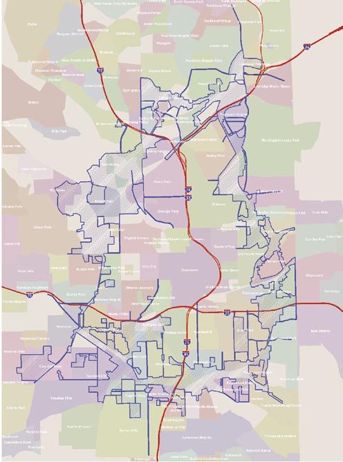
• Streets—new and renovated streets and           land and building parks, trails, transit and
                    intersections including 31 miles of new         other government projects. (The bonds are
                    streetscapes connecting neighborhoods and       secured by the anticipated growth of the tax
                    parks to the BeltLine;                          base within the TAD; the taxpayers of the City
                  • Environmental remediation—clean-up of           of Atlanta will not be obligated to repay the
                    sites with environmental issues;                bonds.) The remaining portion of the project
                  • Neighborhood preservation—preservation          costs is expected to be funded through various
                    of existing single-family neighborhoods         philanthropic and federal sources.
                    by providing appropriate transitions to
                    higher-density uses;                            Already many business and non-profit
                  • Tax base—an estimated $20 billion increase      groups are coming together to begin
                    in tax base over 25 years; and                  implementation of the BeltLine. The Trust
                  • Industrial base—preservation of viable          for Public Land and the PATH Foundation
                    light industry.                                 are planning and locating new parks and
                                                                    paths. MARTA is working on the desirable
                  The BeltLine is an opportunity for Atlanta to     mode for transit. Under the umbrella of the
                  shape its growth for the next 25 years. The       BeltLine Partnership, the implementation and
                  Atlanta Regional Commission forecasts that        fundraising are beginning to take shape. The
                  150,000 new residents will move into the City     Friends of the BeltLine idea of a BeltLine TAD
                  of Atlanta between 2005 and 2030. For the         is becoming a reality.
                  most part, growth has been heavily concen-
                  trated in areas north of downtown. Without        This Redevelopment Plan describes one of
                  the BeltLine that trend would continue. By        the most exciting, but complex projects in
                  providing for approximately 50,000 residents      Atlanta’s history. As the BeltLine will take 25
                  around the 22-mile corridor, or one-third of      years to implement fully, it would be naive to
                  the total expected growth for Atlanta, the        think that this Redevelopment Plan sets firmly
                  BeltLine Redevelopment Plan helps to ensure       in stone every aspect of the BeltLine. It is
                  that this growth is spread equitably across the   best, then, to think of this Plan as a framework
                  City, including previously overlooked areas in    for moving forward. It outlines the major
                  the south and west.                               public infrastructure projects that comprise
                                                                    the BeltLine project. It outlines the type and
                  Most importantly, the BeltLine will provide       scope of development that is consistent with
                  urban amenities and public spaces accessible      good planning practices. It demonstrates the
                  to all Atlantans. Approximately 100,000           feasibility of the TAD to create a majority of
                  Atlantans, or 25 percent of the City’s total      the necessary funding (based on the proposed
                  current population, live within walking           development). But the Plan also anticipates
                  distance of the BeltLine.                         the need for continued public dialogue and
                                                                    decision-making about issues as diverse as
                  Implementation                                    the timing of bond issuances; the design and
                  This Redevelopment Plan contemplates the          development of parks and trails; the exact
                  creation of a BeltLine Tax Allocation District    route of the public transit system; more
                  (TAD) as the primary funding mechanism for        detailed land use plans; and a host of other
                  the many public investments that embody the       critical issues. It has taken hundreds of
                  BeltLine vision. The City considered many         meetings and conversations within the Atlanta
                  sources of funding to pay for the infrastruc-     community to get to this point. There will be
                  ture improvements of the BeltLine. A�er over      many more public meetings and plans over
                  a year of intense review by the members of the    the next 25 years discussing implementation.
                  business, neighborhood and political commu-       The Redevelopment Plan is the necessary first
                  nities throughout Atlanta, the TAD emerged        step on the long road to making the BeltLine
                  as the only viable local funding source.          vision a reality.

                  The BeltLine TAD funds will be generated by
                  new growth in the tax base within the defined
                  TAD Redevelopment Area. Based on this
                  growth, as private development begins, bonds
                  will be sold and the proceeds will be used to
                  fund a portion of the total cost for acquiring

2   /   SUMMARY                                                               REDEVELOPMENT PLAN • NOVEMBER 2005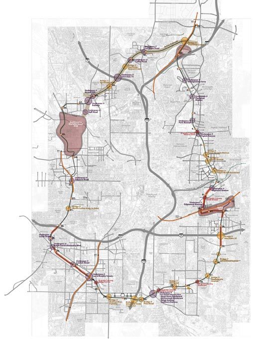
Workforce housing,
                                                              transit, greenspace, trails
                                                              and historic preservation
                                                              are among the many
                                                              benefits of the BeltLine.

 N
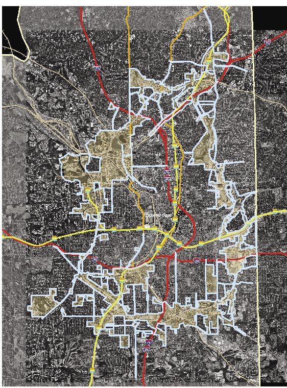
The BeltLine TAD is about 8% of the City’s total land area.

REDEVELOPMENT PLAN • NOVEMBER 2005                                            S U M M A RY   /   3
2.0
Introduction

2.1 The BeltLine Concept                                                 • The reuse of brownfields;
                                                                         • More workforce housing;
The BeltLine proposes to convert underused                               • Economically and socially vibrant hubs of
rail corridors around the city core into a                                 mixed use activity;
continuous system of transit and greenways                               • Be�er access to new and existing recre-
surrounded by parks and pedestrian-friendly                                ational and cultural amenities;
mixed use centers of development. Essential                              • Natural resource protection; and
to the concept is that each of the three key                             • Protection of the unique industrial and
elements—transit, greenspace and develop-                                  rail history of the corridor and its adjacent
ment—is interrelated and that the resulting                                neighborhoods.
network connects seamlessly with MARTA
and other transit opportunities, as well as                              The Development Guidelines (see Exhibit C)
adjacent neighborhoods.                                                  more specifically describe the physical and
                                                                         site characteristics of development consistent
By linking comprehensive land use and                                    with the BeltLine vision.
transportation decisions, the BeltLine becomes
a framework for long-term sustainability that
offers:                                                                   2.2 Growth and Development
                                                                             Context
• A range of convenient mobility choices;
• Job creation and economic investment in                                Current population trends and develop-
  underserved City neighborhoods;                                        ment pa�erns in the City demonstrate the
• Be�er air quality and improved public                                  importance of making coordinated, long-term
  health;                                                                decisions about growth. Population within
                                                                         the City is rising a�er three decades of decline
                                                            forecast
                     600,000
                                                                                                     P OPU L ATIO N   HOUSE HOLDS

                     550,000                                              5 00, 000

                     500,000                                              4 00, 000
P O P U L AT I O N

                     450,000                                              3 00, 000

                     400,000                                              2 00, 000

                     350,000                                              1 00, 000

                     300,000                                                     0
                               1960 1970 1980 1990 2000 2010 2020 2030                1970    1980           1990        2000
                                                YEAR                                                 YEAR

Figure 2.1 City of Atlanta Population, 1960-2030                         Figure 2.2 City of Atlanta Population and
Source: Atlanta Regional Commission, The Atlanta Region                  Households Source: Atlanta Regional Commission
in 2030: ARC Forecasts for Population and Employment                     (atlantareg.com/communitybuilding)

REDEVELOPMENT PLAN • NOVEMBER 2005                                                                                                   INTRODUCTION   /   5
N
Figure 2.3 Percent Population Change by Atlanta Neighborhood Planning Unit, 1980-2000
6 / I NTRODUCTION REDEVELOPMENT PLAN • NOVEMBER 2005(Figure 2.1). Since 1990 the population of the accommodate a significant portion of expected
City has increased from 394,000 to 434,900. growth. This circular corridor within two
The Atlanta Regional Commission (ARC) to three miles of Atlanta’s urban core can
states that Atlanta is the fastest-growing link people, jobs, parks, trails and transit in
city in the region and forecasts a total of vibrant, pedestrian-based mixed use se�ings.
584,000 residents by 2030. This population As a result, the BeltLine will help to enhance
forecast suggests that current growth impacts, mobility for residents.
including traffic congestion, poor air quality,
and the lack of greenspace and pedestrian- In addition to addressing issues related
friendly places will grow more acute. to the amount of growth, the BeltLine can
positively shape the geographic distribution
This Redevelopment Plan is a once-in-a- of development in the City. From 1980 to
generation opportunity to make informed and 2000, significant population increases were
significant planning decisions that will chart heavily skewed to the north and northeast
the course for Atlanta’s future. of Atlanta’s urban core. The neighborhoods
to the west and south of downtown experi-
The important questions are: enced either modest growth or population
decreases during the same two-decade period.
Where will new residents live? Such a physically imbalanced development
pa�ern reduces investment in some sections
Can the City continue to accommodate growth of the City, shrinks the available retail and
without comprehensive discussions about where employment base for residents in areas with
that growth should occur? population loss, and strains the infrastructure
of rapidly growing neighborhoods. The
Can we afford to grow without taking steps to BeltLine can promote greater physical equity
increase parks, greenspace, trails and workforce by a�racting quality development to all parts
housing? of the City.
Can we use best planning practices to ensure It will also have a positive economic impact.
that future growth will encourage viable transit Over 30,000 new jobs are expected to be
options (or will we continue to grow in a way that created in the BeltLine area in the next 20 to 25
maximizes traffic congestion)? years. The job increase is 50 percent greater
than what would be created without the
How does the City change redevelopment pa�erns BeltLine. In addition, during the development
in order to balance economic activity throughout of the BeltLine, 48,000 one-year construction
the City? jobs will be created.
Recent development pa�erns complicate the As this Redevelopment Plan will detail, the
answers to these questions. Family size has BeltLine is the best solution for a wide range
decreased substantially over the last 35 years, of critical issues facing the City.
so that even as the population fell, the number
of households remained steady. (Figure 2.2)
In 1970 the average household size in the City 2.3 Historic Development
of Atlanta was 2.95 people; there were a total
of 162,291 household units in the City. Today, Atlanta’s freight railroads were built a�er the
a much smaller City population lives in more Civil War to expand the industrial base of the
household units (168,147 in 2000). Driving City. These rails for the most part predate the
this change in development pa�erns is a adjacent neighborhoods, weaving through
declining family size that now averages only early industrial areas to form a rough loop
2.3 persons per household. Clearly, the City around the City center. The proposed route
requires more housing units to accommodate of the BeltLine consists of four historic rail
expected growth. segments: the Southern Railway (also known
Railroads shaped the early
as the Decatur Street Belt), the Atlanta & West
physical form of Atlanta.
Though the BeltLine only represents about Point, the Louisville & Nashville, and the
eight percent of the City’s total land area, the Seaboard Air Line.
project can play a critical role in Atlanta’s
future because of the way in which it can
REDEVELOPMENT PLAN • NOVEMBER 2005 INTRODUCTION / 7The railroads were the cornerstone of the Georgia Institute of Technology. The
Atlanta’s economy from the 1800s and early concept is based on the premise that public
19th century through World War II. Various infrastructure spurs and shapes urban growth.
industries housed in simple, utilitarian struc- Gravel’s thesis expanded the Cultural Loop
tures sprung up around the rails, specializing idea, adding mixed use redevelopment of the
in the production, storage, and transport of underused industrial land adjacent to the rail
goods. By the automobile age of the 1950s, corridor and promoting a transit system that
however, industry relied increasingly on truck serves tourists and local residents. The transit
transport. Many industries along the BeltLine line would include intown neighborhoods
sought out cheaper and more plentiful and connect to the MARTA system. Parallel
suburban land, triggering a period of decline bicycle and walking paths would provide a
and disuse in these previously economically 22-mile linear park along the corridor.
stable areas that continued through the 1970s
and 1980s. Only the northwest portion of Beginning in the summer of 2001, with the
the BeltLine has maintained a largely intact support of Councilmember and then City
industrial base. Council President Cathy Woolard, a grass-
roots campaign launched the BeltLine to the
While some areas along the BeltLine corridor forefront of regional transportation projects.
have been revitalized in recent years, the new In February 2004, Councilwoman Woolard
economic activity reflects an emphasis on helped Gravel to establish Friends of the
adaptive reuse, such as residential lo� conver- BeltLine, a non-profit group dedicated to the
sions and boutique retail or infill housing, preservation and comprehensive redevelop-
rather than industry. This shi� in economic ment of the BeltLine.
emphasis has altered pa�erns of ownership
and use along the historic rail segments.
In the southeast, most of the former Atlanta 2.4 Feasibility Study Findings
and West Point segment remains marginally
active, serving a single production facility in In May 2004, Mayor Shirley Franklin identi-
the Ormewood area. The Georgia Department fied the BeltLine as a priority of her admin-
of Transportation (GDOT) owns the stretch istration and tasked the City and the Atlanta
of rail right-of-way on the northern portion Development Authority (ADA) with assessing
of this area, while CSX owns most of the the feasibility of a TAD funding plan. In
southern right-of-way. Norfolk Southern sold March of 2005, the 12-member BeltLine Tax
the 4.3 mile rail right-of-way in the northeast Allocation District Steering Commi�ee led
to a private development group. Originally by Co-Chairs Barney Simms and Dr. Carl
March 2005 TAD
part of the Seaboard Lines system, the north- Pa�on concluded that the TAD was a feasible
Feasibility Study
west segment, now owned by CSX, remains mechanism for funding a significant portion of
the only active rail along the entirety of the the BeltLine project and leveraging additional
BeltLine corridor. The Louisville & Nashville public and private funding.
segment in the southwest is currently inactive
and under the ownership of GDOT. The TAD Feasibility Report (available at
atlantada.com) identified three major findings:
Development of the BeltLine Idea
Over the years, various proposals to reuse 1. TAD funding is likely to generate approxi-
parts of these historic railroads have emerged. mately $1.3 to $1.7 billion in tax-exempt
In the early 1990s, the City of Atlanta envi- bonds over 25 years. The value of the
sioned a Cultural Loop as tourist-oriented bonds would cover about 50 to 70 percent
transportation for the 1996 Olympic Games. of the total estimated cost of the BeltLine.
The route would serve Underground Atlanta 2. TAD bond funds could pay for capital costs
and other cultural sites such as the King to develop transit, trails and parks along
Center, the Atlanta Botanical Gardens and the BeltLine and subsidize other important
King Plow Arts Center. The concept also public policy objectives, including work-
included a bicycle path in some areas. force housing, quality development in
underserved communities, environmental
Ryan Gravel outlined the current Atlanta clean-up, and transportation connectivity
BeltLine proposal in his 1999 graduate (including street, sidewalk and streetscape
thesis in Architecture and City Planning at
8 / I NTRODUCTION REDEVELOPMENT PLAN • NOVEMBER 2005improvements) in neighborhoods close to southwest. The TPL has begun raising funds
the BeltLine. and initiating land acquisition efforts.
3. Development associated with the BeltLine
TAD would generate significant economic The PATH Foundation (PATH) continues to
benefits as described in the Summary. explore opportunities to build demonstra-
tion trail projects along the BeltLine and to
establish design criteria and standards for the
2.5 Cooperating Partners BeltLine trail. PATH has placed emphasis on
11 miles of trail extensions that will link parks
The BeltLine concept has progressed consid- and a�ractions along the 22 mile BeltLine trail
erably in a short time frame as a result of a corridor. It is anticipated that PATH will play
strong commitment and coordinated effort a major role in the implementation of the trails
by multiple organizations. Several partner component of the BeltLine.
interests, in addition to the City of Atlanta and
the ADA, are actively involved in planning The BeltLine’s success also relies on a combi-
the various components of development, trails nation of public and private resources. Once
and transit, and greenspace. The BeltLine the TAD is created, the project will a�ract the
Partnership, a non-profit organization created private investment that generates economic
by Mayor Shirley Franklin and led by Chair momentum for continued implementation and
Ray Weeks, will act as the umbrella entity leverages additional financial support from
that builds consensus and coordinates actions government and the philanthropic commu-
among these multiple organizations. The nity.
BeltLine Partnership’s Board is composed of
Clara Axam, Dr. Gerald Durley, Helen Hatch, This Redevelopment Plan reflects the vital
Richard Holmes, Phil Kent, Chris Sawyer, Tim role of each of these partners in creating
Tuff, and Mtamanika Youngblood. Friends of the BeltLine. As noted earlier, stakeholders
the BeltLine is now an active partner within participated in the development of individual
the BeltLine Partnership umbrella. components of the plan and the recommenda-
tions of this document reflect the findings of
MARTA is concurrently conducting the many previous planning studies. The vision
Alternatives Analysis as the next phase of its and goals that follow are intended as a shared
ongoing Inner Core Feasibility Study. The blueprint to direct public and private deci-
study, scheduled for completion in 2006, sions in the years ahead.
will evaluate the original BeltLine route, the
C-Loop concept linking Northside Drive, the
Cli�on Corridor and the South DeKalb area,
and other hybrid versions of the BeltLine. The
Alternatives Analysis will identify a Locally
Preferred Alternative for transit in the inner
core of Atlanta that is eligible to compete on
a regional and national basis for federal New
Starts transportation funds.
The Trust for Public Land (TPL) in collabo-
ration with urban planner Alex Garvin
completed a 2004 study of greenspace
opportunities along the BeltLine. The report,
The Belt Line Emerald Necklace: Atlanta’s New
Public Realm, outlines the vision for a network
of linear greenspaces and parks totaling about
1,400 acres along the corridor. The study
proposes several iconic spaces that could
solidify the identity of the BeltLine, including
Boulevard Crossing in the southeast, the
North Avenue Park in the northeast, the
Waterworks Park and Westside Park Project
in the northwest, and Murphy Crossing in the
REDEVELOPMENT PLAN • NOVEMBER 2005 INTRODUCTION / 93.0
Outline of Redevelopment
Plan Requirements
To create a TAD, the Georgia Redevelopment 3.1 Overview of Tax Allocation
Powers Law, Chapter 44, Title 36 requires Districts
preparation of a Redevelopment Plan for any
such proposed financing district. The City of Atlanta proposes creation of a
TAD within the BeltLine Redevelopment
The purpose of the Redevelopment Plan is to: Area to fund the public improvements that
will a�ract individual private investment
1. Specify the boundaries of the area and leverage additional government and
proposed for redevelopment. philanthropic financial support for project
2. Provide evidence that the area meets the implementation.
statutory requirements for the creation of a
Tax Allocation District. When a jurisdiction experiences economic
3. Explain the proposed vision for the area development, new projects (whether commer-
and potential for redevelopment. cial, residential or retail) add to the overall
4. Establish the area’s current tax base and tax base, and taxing entities (such as the city,
project the increase in the tax base a�er county and school district) collect higher tax
redevelopment. revenues from these newly developed proper-
5. Define the types of costs that will be ties. Under a TAD, these government entities
covered by TAD funding. continue to collect property tax revenue at a
6. Fulfill all technical requirements as base level in the designated area determined
outlined by the Redevelopment Powers by the tax base at the time the TAD is created.
Law. The property taxes from new projects (known
as “the tax increment”), however, can be used
From May to October of 2005 the ADA and its to fund specifically designated redevelopment
planning team prepared this document based activities in that district. In the case of the
on consultation with various stakeholder BeltLine TAD, such redevelopment activities
interests, including local government officials, will include new parks, trails, transit, environ-
residents, non-profit groups, and developers. mental clean-up, workforce housing and other
The team conducted 13 public meetings and such projects.
over 80 coordination meetings a�ended by
more than 1,600 stakeholders, public officials, Funding for these redevelopment projects can
and residents. be generated over time as incremental taxes
are collected or alternatively can be advanced
The resulting plan articulates an overall through the sale of bonds. When bonds are
vision for the BeltLine and outlines the public sold, the local government can dedicate future
improvements and redevelopment activities tax revenue from the new properties to retire
that would be eligible for TAD funding within the debt. For the BeltLine, issuance of the
the proposed district. bonds is planned to be phased over the life of
the TAD based upon the pace of redevelop-
ment activity. As redevelopment projects are
realized, the stream of future property tax
REDEVELOPMENT PLAN • NOVEMBER 2005 OUTLINE OF REDEVELOPMENT PLAN REQUIREMENTS / 11The TAD is a very powerful financing tool
that can stimulate growth and thus contribute
to job creation, housing opportunities, parks,
and other broad economic development
goals. While most TADs achieve these results
through the direct subsidy of private invest-
ment in economically distressed areas, the
primary purpose of the BeltLine TAD is to
create a network of high quality public ameni-
ties—parks, trails, transit, streetscapes—that
are the driving force to a�ract development.
It is recognized that in some areas of the
BeltLine, the public amenities may not be
sufficient to encourage private development
as envisioned by the plan. In these areas, the
general emphasis on public investments may
be supplemented by targeted development
subsidies to private developers.
3.2 Public Input Process
3.2.1 General Planning Process
This Redevelopment Plan results from a plan-
ning process that was public, transparent, and
comprehensive.
The public involvement component began in
April of 2004 with the creation of the BeltLine
Tax Allocation District Steering Commi�ee.
The public component continued through the
fall of 2005 with the BeltLine TAD redevelop-
ment planning process. That process formally
began in May of 2005 with a City-wide kick-
off meeting to introduce the BeltLine TAD
concept, the project timeline, and upcoming
opportunities for citizen participation. In
May, June and July, the planning team visited
with each of the four NPU clusters to gather
their ideas and priorities and to focus on
strategic neighborhood issues. This input
Figure 3.1 How TADs Work created a unifying framework for the BeltLine
and established a series of recommendations
revenue generated is available to support such and implementation actions to support a
bonds and the debt is issued. shared vision.
It is important to note that TAD bonds are not Each NPU cluster participated in a
backed by the taxing powers of City govern- two-part process to help shape eventual
ment and therefore do not put the City at Redevelopment Plan concepts. The first
legal or financial risk. TAD bonds are backed working session consisted of a four-hour
exclusively by the tax increment from new Saturday workshop where a�endees took part
development in the area. For this reason, in intensive, hands-on exercises. Facilitators
several safeguards, including debt service assigned participants to small groups that
reserves and excess reserve coverage help to examined various issues and proposed goals,
provide greater assurance to the investors that priorities, and concepts in the following areas:
the bonds will be repaid.
12 / OUTLINE OF REDEVELOPMENT PLAN REQUIREMENTS REDEVELOPMENT PLAN • NOVEMBER 2005• Issues and Constraints 3.2.2 Stakeholders’ Issues and Themes
• Resources to Protect The public input gathered during the
• Conceptual Land Use community workshops played a critical role
• Open Space Plan in elaborating on the basic goals established
• Circulation during the TAD feasibility phase. The themes
• Major Development Opportunities and issues highlighted below guided the
development of the recommendations and
The planning team synthesized the resulting specific implementation actions proposed in
public input into a series of dra� diagrams this document.
and maps that illustrated the general vision
of workshop participants, refined by plan- Representatives from the four NPU clusters
ners’ professional views of technical issues, expressed themes specific to their neighbor-
constraints, and sound practices. The team hoods, as well as more general principles
publicly reviewed these dra� concepts as part that overlap with the vision of other BeltLine
of an evening recap session in each cluster. communities. Together the themes listed
The purpose of these sessions was to gather below form a comprehensive public blueprint
additional comments from residents, validate for how the BeltLine should be implemented
the team’s understanding of the concerns and in the years ahead.
priorities of the neighborhoods, and further
refine concepts. The planning team also • Connect the neighborhoods to one another
urged residents to provide ongoing feedback and to key a�ractions;
through wri�en comments. The quality • Make development compatible with
and quantity of public input was excellent surroundings, especially parks and single-
throughout the process, with over 1,600 family neighborhoods;
participants a�ending meetings during May • Protect historic resources and reuse build-
through August. ings where possible;
• Reclaim environmental resources;
During every stage of the process, the plan- • Provide a well-connected and continuous
ning team also reviewed workshop results system of transportation;
with other public and non-profit stakeholders, • Promote transportation alternatives,
including the City’s Department of Planning including pedestrian access;
and Community Development, Department • Strengthen employment and commercial
of Parks, Recreation, and Cultural Affairs, centers, including viable industry where Public involvement
Department of Public Works, and Department appropriate; included a series of
of Watershed Management, as well as • Provide housing for local artists; interactive workshops.
MARTA, the Atlanta Regional Commission • Maintain a variety of residential opportuni-
(ARC), the BeltLine Partnership, the Trust for ties, including mixed-income and work-
Public Land (TPL), the PATH Foundation, and force housing;
Friends of the Beltline. • Preserve and enhance public access to
parks and greenspace;
The public involvement process for the • Create major new open space;
Redevelopment Plan concluded in September • Create neighborhood gateways;
and October with a series of orientation tours • Maintain a high-quality, pedestrian friendly
of the BeltLine, open informational sessions public realm along as much of the BeltLine
at the ADA, and four Town Hall meetings in as possible;
the NPU clusters. Additional opportunities for • Promote mixed use development that is
comment continued through public meetings active at the street level;
scheduled as part of the formal adoption • Balance development around the BeltLine;
process. The supporting documents of this • Promote economic development in
Redevelopment Plan (published separately) economically challenged areas;
contain additional detail on issues, themes • Increase east-west transportation connec-
and concerns raised in each of the NPU cluster tions;
meetings and other community concepts. • Balance industrial activity and new devel-
opment; and
REDEVELOPMENT PLAN • NOVEMBER 2005 OUTLINE OF REDEVELOPMENT PLAN REQUIREMENTS / 13• Maintain light industry and promote the that means using shared surface streets or
creation of jobs for neighborhood residents additional right-of-way acquisition.
that pay a “living wage.”
• Mitigate the impacts of gentrification Parks Maintenance and Public Safety
• Develop a plan to maintain the over 1,200
3.2.3 BeltLine Partnership Land Use Task acres of new greenspace and the BeltLine
Force trail.
• Develop a specific public safety plan for
The BeltLine Partnership formed the Land Use newly developed parks and trails.
Task Force in August 2005. Its more than 22
members representing 16 different organiza- TAD Analysis
tions brought substantial experience in mixed- The financial projections and development
use, residential, retail, office and industrial assumptions as reviewed and revised by
development, workforce housing, planning, the Task Force for the Redevelopment Plan
design and architecture, market research, appear, on balance, to be reasonable.
greenspace and community improvement.
The Task Force was chaired by Dave Stockert,
CEO of Post Properties.
The Land Use Task Force identified the
following recommendations for development
in the BeltLine TAD.
Development Control and Zoning
Enforcement
• Establish enforceable and workable land
use and urban design guidelines focusing
on pedestrian- and transit-oriented mixed
use development, potential reuse of historic
structures and giving consideration to
sustainable building practices.
• Stabilize adjacent neighborhoods through
enhanced public safety and existing
building code enforcement.
Infrastructure
• Complete key street, intersection, and
connectivity improvements simultaneously
with the parks and trails development.
• Establish engineering guidelines and cross-
sections for trail and transit that encourage
a pedestrian-friendly environment.
• Prioritize and acquire additional right-of-
way where needed for plan implementa-
tion.
Connectivity
• Make completion of the entire trail and
adjacent greenspace acquisition a top
priority in early phases of development.
• Develop a comprehensive transit and
pedestrian-bike plan, which achieves
connectivity with existing local and area
community assets (e.g., Carter Center,
Grant Park, MARTA Stations, etc,) even if
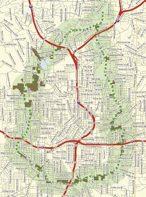
14 / OUTLINE OF REDEVELOPMENT PLAN REQUIREMENTS REDEVELOPMENT PLAN • NOVEMBER 20054.0 Description of the Proposed TAD/Geographic Boundaries The BeltLine Redevelopment Area and TAD includes the property within the boundary as shown on Figure 4.1. The TAD boundary generally follows the 22-mile corridor of abandoned and underused rail right-of-way but also includes nearby properties that meet the following criteria: • Are generally within walking distance of the rail right-of-way; • Form a pedestrian or transit link to key destinations near the rail corridor; and • Are likely to redevelop or will warrant physical upgrades to support expected growth in the area. TAD funds can only be spent within the specified district. For this reason, the boundary, as defined, includes existing parks and the rights-of-way of major corridors to establish eligibility for TAD funding of park, pedestrian and roadway improvements. It should be noted, however, that the TAD excludes existing single-family neighborhoods to protect the integrity of the City’s intown residential fabric. The Redevelopment Area consists of 6,545 acres or eight percent of the City’s total land. As shown in Figures 4.2 and 4.3, the BeltLine affects almost 50 of Atlanta’s intown neighbor- hoods. The complete TAD Redevelopment Area is more particularly described in the materials in Exhibits A and B. REDEVELOPMENT PLAN • NOVEMBER 2005 D E S C R I P T I O N O F T H E P R O P O S E D TA D / G E O G R A P H I C B O U N D A R I E S / 15
N
         Figure 4.1 Proposed BeltLine TAD Boundary

16   /   DESCRIPTION OF THE PROPOSED TAD/GEOGRAPHIC BOU N D A R I E S   REDEVELOPMENT PLAN • NOVEMBER 2005
N Figure 4.2 TAD Boundary with NPUs REDEVELOPMENT PLAN • NOVEMBER 2005 D E S C R I P T I O N O F T H E P R O P O S E D TA D / G E O G R A P H I C B O U N D A R I E S / 17
N
         Figure 4.3 TAD Boundary with Neighborhoods

18   /   DESCRIPTION OF THE PROPOSED TAD/GEOGRAPHIC BOU N D A R I E S   REDEVELOPMENT PLAN • NOVEMBER 2005
5.0
Why the BeltLine Qualifies
as a Redevelopment Area
The State of Georgia “Redevelopment Powers residential, industrial, office, open space,
Law,” OCGA 36-44-1 et seq., allows munici- pedestrian or transit improvements; and
palities to undertake specific actions – such • Any geographic area adversely affected by
as the creation of a tax allocation district – to environmental degradation, contamination,
improve areas within their boundaries found or other environmental factors.
to be “economically and socially depressed”
when viewed on the whole. Various specific The BeltLine Redevelopment Area demon-
criteria may be used to satisfy this broad strates conditions consistent with both parcel-
requirement. The Atlanta City Council must specific and general criteria. A survey of land
officially find an area is qualified based on the uses and structural conditions in the BeltLine
presence of one or more of these criteria. The Redevelopment Area shows that:
criteria (or “indicators”) may be parcel-specific
or may reflect general conditions that affect • More than 400 parcels are either unoc-
the function and health of the Redevelopment cupied or merely partially occupied (6
Area as a whole, and, alone or in combination, percent of the land area in the TAD).
are determined to substantially impair or • More than 560 parcels are in substandard,
arrest the community’s growth, retard housing deteriorated or dilapidated condition (9
or employment opportunities, or constitute an percent of land in the TAD).
economic or social liability and a menace to • Excluding nearby parks added to the TAD
public health, safety, morals, or welfare. These for purposes of maintaining funding eligi-
indicators include but are not limited to: bility, only about 40 open space parcels,
representing 2 percent of total BeltLine
• The presence of a predominant number of land, exist in the area.
substandard, slum, deteriorated, or dilapi-
dated structures; In addition to the parcel-specific quantifi-
• The predominance of defective or inad- able indicators outlined above, the BeltLine
equate street layout; Redevelopment Area as a whole also demon-
• Inadequate parking, roadways, bridges, or strates general characteristics warranting
public transportation facilities incapable of public redevelopment action:
handling current traffic volumes or traffic
volumes following proposed redevelop- • The area is significantly handicapped by
ment; inadequate street layouts and inaccessi-
• The overall lot layout where size, adequacy bility.
or accessibility affects uses; • The presence of rail and previous indus-
• Open lots or parcels of land or a substantial trial uses o�en housed on large, irregu-
number of buildings or structures that are larly shaped lots creates physical barriers
more than 40 years old; between neighborhoods and hampers
• The inadequate provision of open space; internal mobility, as well as access between
• The current condition of the area as devel- the BeltLine and nearby destinations.
oped is less desirable than the redevelop- • There are significant land use conflicts
ment of the area for new commercial, between single family residential areas
REDEVELOPMENT PLAN • NOVEMBER 2005 W H Y T H E B E LT L I N E Q U A L I F I E S A S A R E D E V E L O P M E N T A R E A / 19and adjacent industrial properties, which CATEGORY ACREAGE PERCENT
comprise almost one-quarter of the High-density 23 0.4%
Commercial (HC)
BeltLine area.
High-density Residential 8 0.1%
• A preliminary survey has identified a (HR)
significant number of brownfield parcels, Industrial (I) 1,532 23.4%
particularly in the northwest and south Low-density 813 12.4%
that require environmental remediation Commercial (LC)
resulting from land uses related to the Low-density Residential 53 .8%
(LR)
railroads, as well as industrial activity adja-
cent to the corridor. Multi-Family (MF) 6 0.1%
• There are too few transit options within the Medium-density 307 4.7%
Residential (MR)
Redevelopment Area necessary to accom-
Mixed Use (MU) 117 1.8%
modate the anticipated growth.
Office Institutional (OI) 449 6.9%
Office Institutional 66 1.0%
None of the above indicators, when viewed Residential (OIR)
in isolation, may reflect a pervasive physical
Open Space (OS) 965 14.7%
challenge for the BeltLine area. In the aggre-
Parking (PK) 75 1.2%
gate, however, these conditions constitute
Right-of-Way (ROW) 1,644 25.1%
an interrelated and comprehensive series of
Single-family (SF) 105 1.6%
infrastructure, land use, lot and street layout,
Vacant (V) 382 5.8%
and environmental issues that constrain
the overall redevelopment prospects of the Unknown (UK) 0 0%
BeltLine Redevelopment Area as a whole. TOTAL 6,545 100%
Table 5.1 Summary of Existing Land Use in
The discussion in Sections 5.1 and 5.2 more BeltLine TAD
comprehensively describes the manner in
which the BeltLine Redevelopment Area CATEGORY ACREAGE PERCENT
qualifies as a Redevelopment Area under state Standard 2,910 44.5%
law. Substandard 404 6.2%
Deteriorated 126 1.9%
Dilapidated 35 0.5%
5.1 Issues and Opportunities ROW/Other 3,070 46.9%
TOTAL 6,545 100%
The following sections form an overall profile
of the built environment within the proposed Table 5.2 Existing Building Conditions Analysis
BeltLine TAD boundary. The BeltLine is an
exceptionally diverse geographic area with CATEGORY ACREAGE PERCENT
conditions, including land uses, narrow Unoccupied 141 2.2%
rights-of-way, physical barriers, street layout, Partially Occupied 261 4.0%
and brownfields that create numerous chal- Occupied 2,930 44.8%
lenges for development and substantially ROW/Other 3,213 49.0%
impair the sound growth of the area. Taken TOTAL 6,545 100%
together, these challenges form a barrier to the
provision of appropriate housing and employ- Table 5.3 Existing Building Occupancy Analysis
ment opportunities.
hub of Atlanta and the area’s economic decline
as industry waned in the 60s, 70s, and 80s
The sections that follow summarize issues for
continue to influence its overall existing land
the overall BeltLine Redevelopment Area. The
use and structural pa�erns.
supporting documents provide additional
detail for existing land use, historic resources
More than 23 percent of the BeltLine’s total
and infrastructure in the four geographic
land area remains in industrial use. More than
sections that comprise the BeltLine area.
560 parcels in the area (9 percent) contain
structures that are in less than standard condi-
5.1.1 Existing Land Use and Building
tion. Overall the BeltLine should also be more
Conditions
intensively used given its excellent proximity
As shown in tables 5.1 through 5.3, the
to the urban core. Six percent of the parcels in
BeltLine’s history as the industrial and rail
20 / WHY THE BELTLINE QUALIFIES AS A REDEVELOPMENT AR E A REDEVELOPMENT PLAN • NOVEMBER 2005N Figure 5.1 Existing Land Use Note: See Tables 5.1 through 5.3 for statistical analysis of existing land use, building conditions and building occupancy. REDEVELOPMENT PLAN • NOVEMBER 2005 W H Y T H E B E LT L I N E Q U A L I F I E S A S A R E D E V E L O P M E N T A R E A / 21
the area (more than 400) are currently partially   ROA DWAYS
                                  occupied or unoccupied.                            Due to its size, configuration and land use
                                                                                     history, the BeltLine TAD area includes a
                                  5.1.2 Existing Circulation Framework               full range of roadway types from unpaved
                                  The proposed Beltline is unique as a trans-        roads to interstate highways. Based on
                                  portation route because it is based on railroad    criteria including roadway classification,
                                  corridors, which pre-date the surrounding          annual average daily traffic, accident rates,
                                  neighborhoods. As a result, the BeltLine typi-     and disability compliance, the planning team
                                  cally runs between neighborhoods, rather than      designated for further study 31 major road
                                  through them, resulting in a complex set of        segments in the Redevelopment Area.
                                  connectivity issues. With its industrial roots,
                                  many parcels along the BeltLine are large and      According to the Atlanta Regional
                                  irregularly shaped “super blocks” that further     Commission’s (ARC) travel demand model,
                                  hamper pedestrian access and o�en create           roadway capacity issues exist mainly in the
                                  discontinuous streets. The plan must address       northeast. High-volume corridors, including
                                  these issues as the corridor re-orients from       Peachtree Road, Monroe Drive, portions
                                  freight activity to transit and recreation use.    of North Avenue, and northern portions of
                                                                                     Boulevard strain to accommodate current
                                  In addition to the unusual physical configura-      demand. Aside from capacity, the previous
                                  tion of the BeltLine, a technical review of        industrial uses o�en create discontinuous
                                  existing traffic volume indicates that vehicular     streets or unusually configured intersections
                                  demand exceeds roadway capacity in some            in some areas, particularly the northwest,
                                  parts of the Redevelopment Area, particularly      impairing roadway function and safety.
                                  in the northeast.
                                                                                     B I C YC L E A N D P E D E S T R I A N A M E N I T I E S
                                  The section below summarizes the major             Given the BeltLine’s industrial roots, most
                                  transit, roadway, and pedestrian/bicycle issues    roads in the Redevelopment Area lack
                                  in the BeltLine TAD.                               adequate pedestrian and bicycle facilities.
                                                                                     Few intersections and roads have Americans
                                  T R ANSI T                                         with Disabilities Act (ADA) conforming
                                  As a loop encircling downtown Atlanta, the         ramps, crosswalks, or bicycle lanes. With the
                                  BeltLine has the potential to interact directly    emphasis on mixed use pedestrian environ-
                                  with the transit routes of several transit         ments, sidewalks, streetscapes, pedestrian
                                  providers. MARTA, for example, carries an          crossings, bike lanes, and ADA compliant
                                  average of 500,000 passengers per day on four      design will be critical infrastructure elements.
                                  heavy-rail transit routes and 125 bus routes.
                                  The BeltLine intersects or runs near numerous      5.1.3 Existing Greenspace Framework
                                  bus routes and heavy rail lines in the south-      Atlanta’s existing park system accounts for
                                  east at the Inman Park/Reynoldstown Station,       approximately four percent of the City’s total
                                  the northeast at Lindbergh, the northwest          land area, or about 3,400 acres. The City
                                  at the Bankhead and Ashby Stations, and in         continues to lag behind most other major
                                  the south near Oakland City and West End.          metropolitan areas in a significant quality of
                                  Several other transit agencies, including          life indicator—park acres per 1,000 residents.
                                  Clayton County Transit (C-Tran), Gwinne�           As a result, the City has proposed to increase
                                  County Transit and Cobb County Transit             the amount of dedicated parks and greenspace
                                  provide commuter bus service from outlying         throughout the City by 1,900 acres as part of
                                  counties to the midtown and downtown area.         a broader economic development strategy
                                  Large private developments and institutional       (New Century Economic Development Plan
                                  uses, such as Atlantic Station, Midtown            for the City of Atlanta). The BeltLine TAD
                                  Transportation Solutions, Crawford Long-           Redevelopment Plan is a critical project in
                                  Emory and Georgia Tech also operate shu�le         achieving this broader City goal.
                                  services in the urban core. These services
                                  along with other transit initiatives create a      In general, the shortage of parks is most acute
                                  transportation web with which the BeltLine         in the northwest, where residents consistently
                                  can interact.                                      asked for large new greenspaces to offset the
                                                                                     predominately industrial character of this
                                                                                     area. The southwest enjoys a strong network

22   /   WHY THE BELTLINE QUALIFIES AS A REDEVELOPMENT AR E A                                     REDEVELOPMENT PLAN • NOVEMBER 2005
N Figure 5.2 Existing Major Greenspaces REDEVELOPMENT PLAN • NOVEMBER 2005 W H Y T H E B E LT L I N E Q U A L I F I E S A S A R E D E V E L O P M E N T A R E A / 23
N
         Figure 5.3 Possible Historic Resources
         From preliminary survey conducted by the Atlanta Urban Design Commission

24   /   WHY THE BELTLINE QUALIFIES AS A REDEVELOPMENT AR E A                       REDEVELOPMENT PLAN • NOVEMBER 2005
of neighborhood parks, but currently lacks a within a half mile of the BeltLine corridor.
signature public gathering space. The south- Overall, the survey (see Figure 5.3) classified
east and northeast have regional amenities, more than 500 resources near the BeltLine
such as Grant Park and Piedmont Park, but as contributing. Buildings or structures are
they do not have the smaller neighborhood considered to be “contributing” to the historic
spaces to complement recent and projected character of the district if they are of the same
strong residential growth. In general, resi- period as the other historic resources in the
dents in all BeltLine communities identified district, possess a certain degree of integrity
active recreation facilities as an ongoing need. (i.e., they have not been substantially and
irreversibly altered), and if they are within the
5.1.4 Historic Resources designated boundary of the district.
The BeltLine is a remarkable artifact showing
the physical origins of Atlanta during the It should be noted that the survey of
railroad age. It represents the growth of the possible historic resources in and near the
City and the relationships between industry Redevelopment Area is preliminary. These
and housing at the beginning of the period of inventories, however, are a critical tool for
rapid industrialization a�er Reconstruction. It defining those areas that may require more
also reflects the shi�s in land use and building site-specific analysis and in guiding proposed
pa�erns as this industry waned in the inner redevelopment toward the preservation and
core. Though the rail right-of-way is three- reuse of Atlanta’s rich historic fabric.
quarters underused, the BeltLine persists
as a physical chronology of the events that 5.1.5 Brownfields
propelled Atlanta to its place as the regional Given the historic presence of active rail and
capitol of the Southeast. Redevelopment must industry, environmental contamination poses
properly consider sensitive resources along a major challenge for the redevelopment of
the BeltLine, so that this new chapter in the some currently underused BeltLine sites.
evolution of the City retains historic character.
The City’s brownfield consultant, MACTEC,
There are many different types of historic has performed a preliminary brownfield
assets along the BeltLine, including manu- assessment of the BeltLine corridor. The
facturing buildings, shipping and transfer survey identifies as brownfields those proper-
warehouses, older residential subdivisions, ties with possible subsurface contamination
structures for public utilities, apartment due to past or current suspect activities on the
buildings, schools, historic parks, company site that are severe enough to affect redevelop-
housing, local commercial districts, and the ment costs; or properties that are in hydro-
railroad infrastructure itself. The years repre- logic proximity to other sites of environmental
sented vary between the turn of the twentieth concern.
century and the 1960s. There are individual
buildings which are significant for the activi- As shown in Figure 5.4, a survey of potential
ties they contained, and buildings that are brownfield sites identifies parcels sca�ered
architecturally valuable. There are buildings along the corridor. The northwest cluster has
which are prized as intact complexes, and a particularly distinct concentration of sites
buildings that are ordinary individually but with potential contamination issues along the
exceptional in their geographic concentrations. rail right-of-way. Brownfields may also affect
There are historic districts and Civil War the redevelopment prospects of parcels along
landscapes. And there are riveted iron bridges the extreme southern segment on the BeltLine.
and wooden trestles, iconic signals and a
hand-hewn granite tunnel. All of this physical 5.1.6 Wastewater Capacity
diversity in a once thriving employment zone To determine any possible capacity limita-
creates a rich and unique character– a�ributes tions, the City’s Department of Watershed
that can make the BeltLine unlike any other Management (DWM) compared estimated
network of urban space in America. wastewater flows from proposed rede-
velopment project sites in the BeltLine
In an effort to protect these rare resources, Redevelopment Area to available treatment
the Atlanta Urban Design Commission has capacities in the affected watershed units.
conducted a field survey of potentially historic
structures, sites, buildings, and neighborhoods According to the Department’s analysis:
REDEVELOPMENT PLAN • NOVEMBER 2005 W H Y T H E B E LT L I N E Q U A L I F I E S A S A R E D E V E L O P M E N T A R E A / 25You can also read


