Autonomous marine vehicles in sea surveillance as one of the COMPASS2020 project concerns - IOPscience
←
→
Page content transcription
If your browser does not render page correctly, please read the page content below

Journal of Physics: Conference Series

PAPER • OPEN ACCESS

Autonomous marine vehicles in sea surveillance as one of the
COMPASS2020 project concerns
To cite this article: Sanja Bauk et al 2019 J. Phys.: Conf. Ser. 1357 012045

View the article online for updates and enhancements.

                                This content was downloaded from IP address 176.9.8.24 on 19/05/2020 at 04:54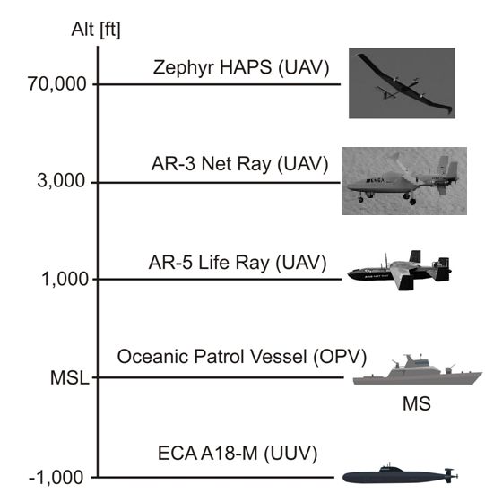
MTEC/ICMASS 2019                                                                                                IOP Publishing
IOP Conf. Series: Journal of Physics: Conf. Series 1357 (2019) 012045                     doi:10.1088/1742-6596/1357/1/012045

  Autonomous marine vehicles in sea surveillance as one of the
  COMPASS2020 project concerns

                      Sanja Bauk1,2, Nexhat Kapidani3, Žarko Lukšić3, Filipe Rodrigues4, Luís Sousa4

                      1
                        Maritime Faculty Kotor, University of Montenegro, Montenegro
                      2
                        Dep. of Maritime Studies, Faculty of Applied Sciences, Durban University of Technology, SA
                      3
                        Maritime Safety Department of Montenegro, Montenegro
                      4
                        TEKEVER ASDS, Portugal

                      E-mail: zarko.luksic@pomorstvo.me;

                      Abstract: Coordination Of Maritime assets for Persistent And Systematic Surveillance
                      (COMPASS2020) is an EU H2020 project, which has as an overarching goal deployment of
                      Unmanned Vehicles (UxV) - aerial, sea surface and underwater ones, in addition to manned
                      offshore patrol vessels, to enhance current maritime border surveillance operations regarding
                      detection of irregular migrants and narcotics smugglers. This paper gives an overview of several
                      research projects on autonomous marine vehicles, as a key technological, organizational and
                      legislative issue within the project scope: Kaisa, an autonomous vessel prototype built at SAMK
                      Faculty of Logistics and Maritime Technology in Rauma (Finland). Autonomous Ships 101 from
                      Solent University in Southampton (England). A review of other articles has served as a
                      comparative analysis to the surveillance assets proposed by COMPASS2020.

                      Key words: autonomous marine vehicles, taxonomy, state-of-the-art, concurrent activities in
                      enhancing security of borders at sea.

  1. Introduction
  In 2015 European Union (EU) has been faced with 1.8 million illegal border crossings. This is more than
  six times the number of detected illegal migrations in 2014. It takes three years to change the situation
  and to reduce by nearly 90% the illegal border crossings and reassure the security of EU borders.
  However, there is still pressure on EU external borders, especially when it comes to the Western
  Mediterranean route. Therefore, COMPASS2020 project has been conceived to reduce the number of
  illegal border crossings through improving coordinated actions supported by manned and unmanned
  (underwater, sea surface and air) vehicles (UxV). Besides struggling with illegal migrants, EU has a
  problem related to narcotics trafficking. It is estimated that every year approximately 125 tones of
  cocaine worth USD 33 billion are consumed, the majority coming from Latin America to Europe on
  transatlantic routes. There are some new narcotics routes from Northern and Eastern Africa targeting
  Spain and Portugal, while the most traditional routes target Belgium and the Netherlands, i.e., major
  European shipping ports. Consequently, COMPASS2020 was also conceived to combat this issue. To
  address these challenges, COMPASS2020 proposes the development of a unified system based on open
  standards that will enable the combined operation of multiple unmanned assets (from distinct providers),
  manned platforms currently used under marine surveillance context, and the future accommodation of
  other platforms and services with minor integration efforts. The project contributes to improve the

              Content from this work may be used under the terms of the Creative Commons Attribution 3.0 licence. Any further distribution
              of this work must maintain attribution to the author(s) and the title of the work, journal citation and DOI.
Published under licence by IOP Publishing Ltd                          1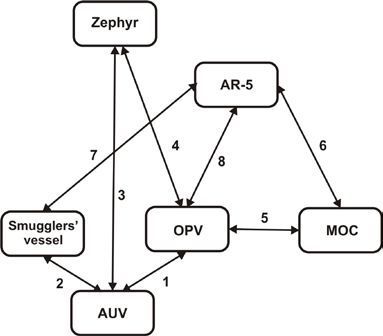
MTEC/ICMASS 2019                                                                              IOP Publishing
IOP Conf. Series: Journal of Physics: Conf. Series 1357 (2019) 012045   doi:10.1088/1742-6596/1357/1/012045

 situational awareness beyond coastal waters through integration of multiple manned and UxVs operating
 in different environmental conditions, ranges and altitudes. On the other hand, pollution monitoring is
 also an increasingly important part of maritime safety, as global commerce increases from/to the EU,
 leading to a growth of vessels and cargos crossing European waters. Higher maritime traffic results in a
 higher probability of occurrence of pollution incidents, such as oil spills, as well as an increase in ships
 sulfur emissions. Such incidents, especially the ones that occur due to severe weather conditions (strong
 winds and high sea state) can lead to high negative impacts to the environment. In this context, the
 solutions under development in the project represent safe alternatives to monitor such disasters, in
 particular in remote areas where access through manned assets may represent life-threatening risks to the
 operators. Therefore, the COMPASS2020 platform can be an answer to such situations, providing a cost-
 effective solution based on UxVs that can be highly effective and, at the same time, reduce the risk to the
 humans involved in the operation, with the ultimate goal of minimizing the impact of this kind of
 incidents [1, p.3].
     The paper is organized in a manner that its first part describes COMPASS2020 in some more detail;
 the second one deals with terminology and different levels of autonomous marine vehicles self-managing
 capacities; the third one gives literature review on several recent projects and achievements in the filed;
 while the last one provides conclusion and highlights further research endeavors in achieving concurrent
 command, control and tracking of multiple manned and unmanned air, sea surface and underwater
 vehicles in the marine environments which are exposed to the risk of illegal border crossings and threats
 of trafficking of narcotics, including consequent search and rescue activities.
 2. The COMPASS2020 key roles
 The COMPASS2020 project is expected to achieve a comprehensive solution for maritime surveillance,
 based on the coordination of manned and unmanned assets with enhanced capabilities, which will allow
 addressing many of the challenges currently faced by authorities and governmental organizations with
 responsibilities in this domain. The ultimate goal of this solution is to help governments contain, control
 and effectively respond to a growing number of diverse threats and incidents: from piracy and smuggling
 of goods and narcotics, to irregular migration and maritime pollution, including Search and Rescue
 operations. Due to the afore stated, the COMPASS2020 project proposes to demonstrate the benefits of
 the developed solution by tackling two specific scenarios during the project’s lifetime: (i) Search and
 Rescue mission derived from irregular migration and (ii) interception of narcotics smugglers. For these
 purposes the following assets will be used: (1) the Oceanic Patrol Vessel (OPV) operated by the
 Portuguese Maritime Authority designed as a multi-mission platform; (2) AR-3 Net Ray - a fully
 autonomous small-UAV with an endurance of up to 10 hours and a range of up to 150 km, launched by
 catapult and recovered by a net or parachute. It can serve maritime and coastal surveillance missions,
 working as operational extender for vessels as well as a communications relay to other vehicles and
 communications range extender; (3) AR-5 Life Ray - a medium-altitude and medium-endurance fixed-
 wing UAV specifically designed for search and rescue, long range surveillance and maritime patrol (up
 to 16 hours of endurance and a range of 1600 km); (4) Zephyr HAPS (UAV) - a high altitude pseudo-
 satellite (HAPS) that fills the gap between satellites and UAVs (70000 ft). This platform is being
 conceptually considered as part of the COMPASS2020 solution as it enables real-time mapping, internet
 and a number of surveillance opportunities to meet a broader range of requirements; (5) the A18-M - an
 autonomous underwater vehicle (AUV) that can be launched from OPV - it is capable of performing
 autonomous missions up to 300 m depth and it is easily transportable by plane for overseas missions. Its
 area of coverage is 2 km2 per hour and it is widely used for defense and security actions. The layout of
 the main COMPASS2020 assets is shown in Figure 1.

                                                       2
MTEC/ICMASS 2019                                                                              IOP Publishing
IOP Conf. Series: Journal of Physics: Conf. Series 1357 (2019) 012045   doi:10.1088/1742-6596/1357/1/012045

              Figure 1. Scheme of COMPASS2020 four layered (un)manned architecture
                                                (Source: Own)

     In the case of search and rescue (SAR) mission derived from an irregular migration situation – a
 vessel carrying irregular migrants is in a distress situation beyond coastal waters, sending out EPIRB
 (Emergency Position Indicating Radio Beacon) signal in order to alert the European authorities. At the
 first phase of the mission, three types of assets are in the area performing persistence surveillance: the
 OPV, the Zephyr, and the A18-M. At the moment it receives the EPIRB alert, Zephyr immediately
 communicates this information to the operational commander that is working from the Marine
 Operations Center (MOC) through the COMPASS2020 Mission System (MS) replica onboard the OPV.
 In the following phase, the OPV will launch an AR-3 capable to collect data regarding the vessel in
 distress, thus enhancing the situational awareness of marine authorities concerning the risk level of the
 situation and allowing them to act timely and properly [1, p.11]. This action/data flow is schematically
 shown in Figure 2.

    Figure 2. Action/information flow in the case of SAR mission derived from irregular migration
                                                (Source: Own)

     When it comes to interception of narcotics smugglers – the OPV, the Zephyr and the A-18 M are in
 action in the border area. The Mission System (MS) is running onboard the OPV and it is always
 connected with its replica at MOC. Zephyr is launched from MOC and it has to collect an overall picture
 of the area that is being surveyed. In addition, an AUV was previously deployed from the OPV into a
 strategic location that is coincident to the traffickers’ typical routes. The AUV is programmed to follow
 circular trajectories in the area of interest, navigating underwater at low depth in order to remain
 undetected from the smugglers and staying closely enough to the surface in order to optimize the

                                                       3
MTEC/ICMASS 2019 IOP Publishing
IOP Conf. Series: Journal of Physics: Conf. Series 1357 (2019) 012045 doi:10.1088/1742-6596/1357/1/012045
possibility of detecting the target. It carries a set of hydrophones that enable detecting speed boats. After
detection of the target, the AUV can communicate to the Zephyr, which is used as a communication relay
in the system. The Zephyr sends automatically an alert to MS onboard OPV and its replica in the MOC.
Once the MOC receives the alert, the officers proceed with the deployment of an AR-5 platform. The
AR-5 has to come close to the vessel and acquire more detailed information about it. In accordance to
this information, the officer onboard OPV can decide how to intercept the threat and act efficiently. If the
smugglers try to get rid of the cargo, the AUV has the capacity of searching for it by making use of side
scan sonar [1, p.10]. Data flow in this type of action is given in Figure 3.
Figure 3. Action/information flow in the case of interception of narcotics smugglers
(Source: Own)
3. Maritime autonomous vehicles taxonomy
The most advanced components of the surveillance and supplementing SAR actions proposed by
COMPASS2020 in order to address the challenges mentioned above are unmanned (air, sea, and
underwater) vehicles, or shortly UxVs. The operational coordination of thes kinds of assets is an under-
explored field and therefore below will be given some basic information concerning operation of marine
fully autonomous and unmanned vehicles.
The first implementation of unmanned vehicles took place in space transport. Then, commercial use
of rail unmanned transport devices was implemented to carry freight and people. Further applications
take place in air transport for both military and civil transport purposes. Commercial use of autonomous
cars and trucks on generally accessed roads are still at the phase of research. Similar situation is within
sea transport [2].
The implementation of autonomous and unmanned vehicles at sea has to be preceded by solving
numerous problems concerning legal, organizational and technological issues. When it comes to legal
issues, International Maritime Organization (IMO) is working on it [3]. Recently, Maritime Safety
Committee has been established as a working group dealing with safety issues at and in the vicinity of
places where tests over autonomous and unmanned vessels are done. Besides this, Loyd’s Register (LR)
produced a document entitled “Cyber-enabled ships: Ship Right procedure – autonomous ships” (2016).
In 2017 it produced another document titled “LR Code for Unmanned Marine Systems”, which identifies
goals and objectives for different unmanned vehicles [4]. Also, it is important to mention that LR defines
seven autonomous levels of marine vehicles:
• AL0: no autonomous functions; all operations are manual;
• AL1: on-vessel decision support; data will be available to crew;
• AL2: off-vessel decision support; shore monitoring;
• AL4: human-on-the-loop; semi-autonomous vessel; crew can intervene;
• AL5: fully autonomous vessel; there is a means of human control;
• AL6: fully autonomous vessel that has no need for any human intervention.
On the latter ends of this scale one can see further class of vessels/ships called unmanned and this
refers to vessels that are operated remotely so there is no one on board. Today almost all vessels have a
certain level of autonomy, since numerous functions operate by themselves. So, the transition from
4MTEC/ICMASS 2019 IOP Publishing
IOP Conf. Series: Journal of Physics: Conf. Series 1357 (2019) 012045 doi:10.1088/1742-6596/1357/1/012045
“classical” to autonomous vehicles used at sea will be evolutionary rather than revolutionary. In other
words, the transition will be gradual, and it will last most probably several decades.
Different operational issues are still unsolved and under consideration. However, technological
solutions are already available to a large extent. Intensive research is done, including simulation tests,
experiments on physical models and construction of prototypes. Below are listed some of the relevant
projects in this domain [2]:
• MUNN – Maritime Unmanned Navigation through Intelligence in Networks;
• AAWA – Advanced Autonomous Waterborne Applications Initiative;
• STM Validation – Sea Traffic Management Validation Project
• AVAL – Autonomous Vessel with an Air Look, etc.
The basic information on these projects are available online. The COMPASS2020 is relying in terms
of technology, safety and security [5] on findings of these and several other projects in the field. They are
listed and shortly described in the COMPASS2020 proposal [1, p. 18-20]. It is realistic to expect that
research and development (R&D) activities will be continued in order to ensure successful
implementation and sustainability of COMPASS2020, including follow-up projects in the future.
4. Some R&D achievements
In attempt to support further activities within COMASS2020 project, we have made a search of similar
research endeavors when it comes to autonomous and unmanned maritime vehicles. Thanks to our
professional contacts we are introduced with the Faculty of Logistics and Maritime Technology of
Satakunta University of Applied Scieneces (SAMK) from Rauma (Finland) work on building and testing
of the autonomous ship technology on miniature training ship Kaisa (Figure 4). This work has been done
in collaboration with Rolls-Royce Ltd and WinNova Ltd, the institute for vocational training education in
Satakunta. Namely, the platform called ELSA utilized the miniature training ship Kaisa built in 1994,
which is a model of passenger cruise ship Society Adventurer built in 1991. The detail description of this
autonomous sea vehicle can be found in reference [6].
Figure 4. Kaisa prototype of an unmanned vessel
(Source: [6])
The model is remotely controlled from the control center. The center is located in the main building of
the Faculty of Logistics and Maritime Technology of SAMK. It is equipped with large LCD screens for
displaying the image provided by the onboard cameras, sensor data display and human machine
interaction panel for remote manual steering of Kaisa. The lidar and machine vision data are collected
onboard. The track control and DP computers for fully automated operation of the model are located in
the remote-control center. The data transmission link between the vessel and the control center is a
crucial part of the whole system and 4G network is used for this purpose. Kaisa is an objectified
experiment used for students training and as an experimental polygon for postgraduate students at SAMK
work on their master and doctoral thesis. It has certain advantages in comparison to simulation (more
realistic) and full-size testing (more cost-effective). Continuation of experiments over Kaisa should bring
new findings in the filed, which support (in)directly some challenges within the COMPASS2020
platform, particularly when it comes to data fusion and UxVs self-managing functions.
In addition to this experiment on a prototype in laboratory setting, numerous theoretical studies have
been recently conducted. Some of them will be mentioned here as kind of guidelines for further research
work within COMPASS. For instance, one research concerns Autonomic Computing (AC) as a potential
solution to implement efficient self-management (self-managing capacities as: self-healing, self-
protecting, self-organizing, self-optimizing and self-configuring) in autonomous maritime vehicles
(AMVs) [7]. The aim of this research work is to indicate that the advanced versions of AC with fully
5MTEC/ICMASS 2019 IOP Publishing
IOP Conf. Series: Journal of Physics: Conf. Series 1357 (2019) 012045 doi:10.1088/1742-6596/1357/1/012045
integrated approach to autonomous capacities for next generation of AMVs should be more similar to
human physiology and behavior.
There is also a comprehensive research work on AMVs in the domain of optimal path planning and
control methods with different sensor technology like sonar, laser, acoustic modems and stereo vision
systems for localization, navigation and mapping [7;8]. Also, it is important to mention that underwater
wireless communications have recently achieved development [9]. Communication links and data fusion
along with central control system and human-machine interface are among the key concerns within the
COMPASS2020 and its successful implementation, so that the above listed research studies and similar
ones might be use as referential at some point.
It is worth to mention in this context two extensive studies on autonomous/unmanned vehicles
perception [10;11]. The first study provides up-to-date information about the advantages, disadvantages;
limits and ideal applications of specific sensors. The second one deals with putting men back in the
headlines despite the rise of autoimmunization in marine and shipping industry. Namely, according to
this study “85% of those surveyed agreed that seafarer skills will remain an essential component in the
long-term future of the shipping sector” [11, p.4]. In other words, the findings of the study suggest that
the human will remain an essential component in the long-term future of shipping, even if that future is
autonomous.
5. Conclusion
The paper gives an overview of EU COMPASS2020 project developed for surveillance and SAR actions
at sea in situations of illegal migrations (border crossings) and narcotics trafficking (interception of
narcotics smugglers). The architecture at high level and core action/information flows of the system are
presented. Since the system deploys autonomous and unmanned (air, sea surface, and underwater)
vehicles, taxonomy dealing with these advanced and complex vehicles, including the degree of their
autonomy is given, as well. In order to support further R&D activities within the project, some recent
experimental and theoretical studies in the field are introduced. As next steps in our research work, we
plan to explore in some more detail technological performances of each asset within COMPASS
including communication channels and protocols [12], as well as data fusion and presentation on the
network application layer. This will be done in parallel with experiments in real setting, i.e., in maritime
environment under risk threats.
Acknowledgements
This work has been partially funded by the EU Research and Innovation program HORIZON 2020,
COMPASS2020 project - Grant Agreement No: 833650
References:
[1] COMPASS2020 – Coordination of Maritime assets for Persistent And Systematic Surveillance,
Project documentation (Boosting the effectiveness of the Security Union, H2020-SU-SEC-
2018-2019-2020), pp. 1-70.
[2] Pietrzykowski Z., Hajduk J., Operations of Maritime Surface Ships, Proceedings of the 13th
TransNav Conference, June 12-14, 2019, Gdynia, Poland (to appear).
[3] MSC 98/20/2. Maritime Autonomous Surface Ships. Proposal for a regulatory scoping exercise.
Submitted by Denmark, Estonia, Finland, Japan, the Netherlands, Norway, the Republic of
Korea, the United Kingdom and the United States. 27th February 2017.
[4] Meadow G.C., Cross J., Autonomous Ships 101, The Journal of Ocean Technology, Vol.12, No.3, pp.
23-27.
[5] Laurinen M., Advanced Autonomous Waterborne Applications Initiative – AAWA Seminar Helsinki,
Finland. Available from Internet, Last acces on June 6, 2019).
[6] Ahvenjarvi S., Platform for Development of the Autonomous Ship Technology, in Marine Navigation
(Ed. A Weintrit), Proceedings of the 12th International Conference on Marine Navigation and
Safety of Sea Transportation (TransNav 2017), June 21-23, 2017, Gdynia, Poland, pages 5.
[7] Insaurralde C.C., Autonomic computing technology for autonomous marine vehicles, Ocean
Engineering 74 (2013) 233-246.
[8] Hinostroza M.A., Haitong Xu, Guedes Soares C., Cooperative operation of autonomous surface
vehicles for maintaining formation in complex marine environment, Ocean Engineering 183
(2019) 132-154.
[9] Sahoo A., Dwivedy S.K., Robi P.S., Advancements in the field of autonomous underwater vehicle,
Ocean Engineering 181 (2019) 145-160.
[10] Van Brummelen J. et al., Autonomous vehicle perception: The technology of today and tomorrow,
6MTEC/ICMASS 2019 IOP Publishing
IOP Conf. Series: Journal of Physics: Conf. Series 1357 (2019) 012045 doi:10.1088/1742-6596/1357/1/012045
Transport Research Part C 89 (2018) 384-406.
[11] Meadow G., Ridgwell D., Kelly D., Autonomous Shipping – Putting the human back in the
headline, Institute of Marine Engineering, Science & Technology – IMAREST, Sigapore, April
2018, pp. 1-23.
[12] Bauk S., A Review of NAVDAT and VDES as Upgrade of Maritime Communication Systems,
Proceedings of the 13th TransNav Conference, June 12-14, 2019, Gdynia, Poland (to appear)
7You can also read