BLACKROCK PARK SITE ANALYSIS 2020 - Dún Laoghaire-Rathdown County Council
←
→
Page content transcription
If your browser does not render page correctly, please read the page content below
BLACKROCK PARK SITE ANALYSIS 2020
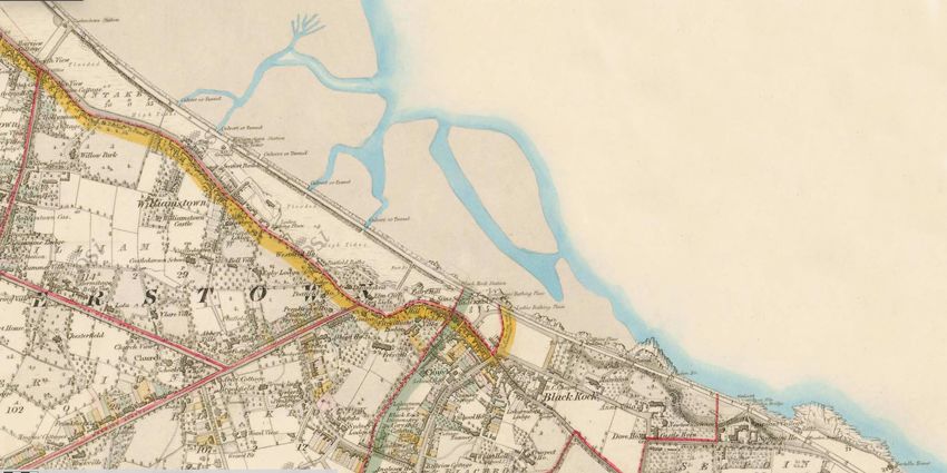

TABLE OF CONTENTS

                                                               01       AIMS AND OBJECTIVES						04|05

                                                               02
                                                             			PLANNING CONTEXT & RELEVANT POLICIES			   06|09

                                                               03
                                                             			EXISTING ARRANGEMENT						10|12

                                                               04
                                                             			HISTORICAL CONTENT						13|14

                                                               05		GEOGRAPHICAL CONTENT						15|16

View of a heritage granite pillar, Blackrock Park entrance
                                                               06
                                                             			S.W.O.T ANALYSIS							17|20

                                         at Merrion Avenue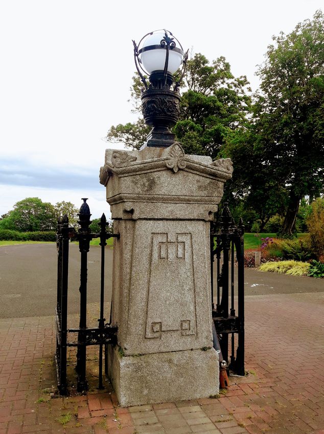
01
AIMS AND OBJECTIVES
To facilitate the on-going development of Blackrock Park in a holistic manner avoiding a piecemeal approach to development. The Masterplan is now being reviewed and updated
to solve a number of on-going logistical challenges.
The following aims and objectives are being used to formulate the Blackrock Park Masterplan;
1. Develop the park in a holistic and sustainable manner and explore the use of renewable energy for the parks energy requirements.
2. Maximise tree canopy cover in the park and where appropriate implement nature-based solutions in line with Councils Climate Change Action Plan 2019-2024.
3. Strategically shape Blackrock Park as a ‘Gateway Park’ on the threshold between Dun Laoghaire Rathdown and Dublin City.
4. Establish a unified park connecting the necklace of spaces between Blackrock and Booterstown.
5. Put in place a long term vision for Blackrock Park. Arrange the park and its elements into a logical order to exploit the parks amenity value within the context of
the historic landscape.
6. Conserve and restore the built heritage and provide suitable, sympathetic and sustainable uses for the properties in the setting of the Regional Park.
7. Protect and enhance the natural heritage, flora & fauna and marine heritage of the park.
8. Reinstate the historic Victorian layout within the heritage section of the park.
9. Increase the horticultural offering in the park in a sustainable manner. An emphasis on bold, naturalistic sweeps of herbaceous planting suitable for the local
conditions.
10. Encourage greater footfall and daily use within the park, with a suitable and appropriate level of visitor facilities provided throughout the park.
11. Dymanic passive recreational facilities including rest and relaxation spaces in appropriate locations
12. Develop high quality active recreation facilities, available to a wide range of the population in order to encourage a more active lifestyle.
13. Develop a stronger physical connection with Blackrock Village and the surrounding areas.
14. Create a stronger physical and visual connection with the coastline.
15. Upgrade the existing greenway in the park for walking and cycling.
16. Develop a way-finding strategy for the park and surrounding areas.
17. Foster greater community engagement and educational programmes associated with the park.
18. To acknowledge the size and scale of the park through strategic interventions that will also benefit the broader county.
19. To ensure the final adopted Masterplan is used in its entirety for the development and conservation of Blackrock Park without significant amendment.
BLACKROCK PARK | DRAFT SITE ANALYSIS
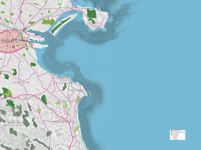
4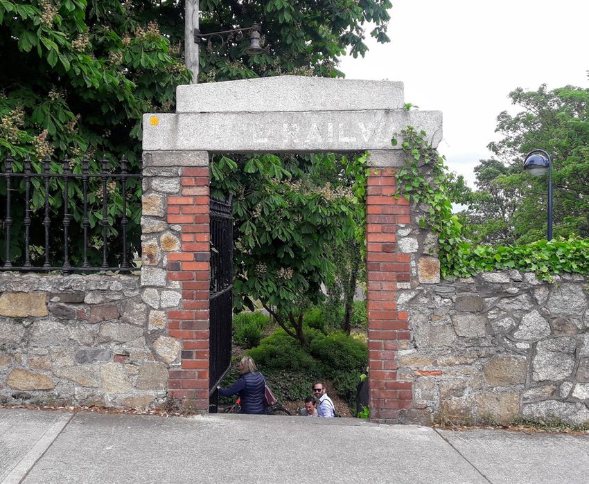
S I TE L O C A TI O N I N D ÚN L A O G HA I R E R A THD O W N

                                       There are 63 parks and 337 open spaces identified within the urban area of
                                       Dún Laoghaire-Rathdown County. These range in size from large suburban
                                       public parks to local pocket parks and squares. There is also a hierarchy of
                                       open spaces from regional parks, district parks, local parks, amenity open
                                       space and civic open space. Regional parks currently include Marlay Park,
                                       The People’s Park and Newtownsmith, Killiney Hill Park, Cabinteely Park
                                       and Blackrock Park. These provide multifunctional benefits and form an
                                       important tapestry of green infrastructure in Dún Laoghaire-Rathdown
                                       County.

                                       Within DLR, Blackrock Park is in a key location for introducing the
                                       coastal route and connecting with the intra urban and rural corridors.
                                       This corridor extends into surrounding counties; Dublin City to the
                                       north and Wicklow County Council to the south.

                                       The area defined as Blackrock extends from the Punchbowl pub and
                                       Booterstown Road in the north, to Monkstown & Kill Lane in the South and
                                       the N11 marks the boundary on the western edge. The land rises steadily
                                       from the coastline to its highest point of approx. 87m above sea level which
                                       is at the junction between the N11 and Newtownpark Avenue at White’s
                                       cross.

BLACKROCK PARK | DRAFT SITE ANALYSIS

                5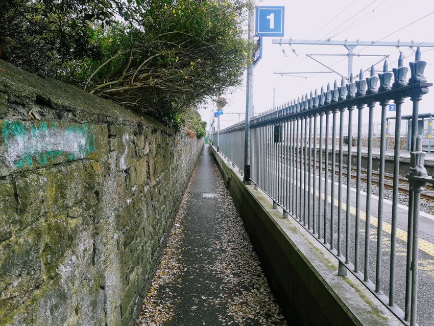
02
                      PLANNING AND RELEVANT POLICIES                                                                                                                                                                                              BLACKROCK PARK

2.1       County Development Plan (CDP)- Strategic Level Vision for the County

The CDP (2016-2022) is informed by both National and          guided by the policies and strategic objectives set out in
Regional policy documents. It is a strategic level document   both the CPD and the LAP.
that sets out the long term vision for Dun Laoghaire
Rathdown in the form of policies, objectives and high         The CPD is broken down into 10 sections. Section 4-Green
level planning. The Blackrock Local Area Plan (LAP), in       County Strategy, is the most relevant. Within this section
turn, is shaped by the objectives and policies set out in     there are several key policies that feed into the landscape
the CPD. The park site analysis and masterplan has been       masterplan.

      Section 4.1-Landscape, Heritage & Biodiversity.             Section 4.2- Open Space & Recreation

      To protect the existing unique heritage within the          To foster and create accessible open space in close
      county.                                                     proximity to communities.

      •         Policy LHB2: Preservation of Landscape            •         Policy OSR1: Green Infrastructure
                Character Areas                                             Strategy
      •         Policy LHB3: Seascape                             •         Policy OSR3: Hierarchy of Parks and
      •         Policy LHB6: Views and Prospects                            Open Space
      •         Policy LHB9: Coastline Parks and                  •         Policy OSR4: Future Improvements
                Harbours                                          •         Policy OSR7: Trees and Woodland
      •         Policy LHB19: Protection of Natural               •         Policy OSR8: Greenways Network
                Heritage and the Environment                      •         Policy OSR10: Sports and Recreational
      •         Policy LHB21: Biodiversity Plan                             Facilities
      •         Policy LHB23: Non-Designated Areas of             •         Policy OSR11: Protection of Sports
                Biodiversity Importance                                     Grounds/Facilities
      •         Policy LHB24: County-Wide Ecological
                Network
                                                                                                                                                                                   Blackrock LAP and Blackrock Park in relation to other regional parks in Dun Laoghaire Rathdown

The Blackrock Local Area Plan (2017-2023) makes specific references to Blackrock Park and the land around it. Section 9.2 (Map 17) sets out key objectives.

To avoid a full regurgitation of text, only the most relevant policies  are included within this site analysis. A perusal of the CDP and the LAP will give a more detailed understanding of the documents:

County Development Plan 2016-2022
https://www.dlrcoco.ie/en/planning/county-development-plan/county-development-plan-2016-2022

Blackrock Local Area Plan 2015-2021
https://www.dlrcoco.ie/en/planning/local-area-plans/blackrock-lap-2015-2021

                                                                                                                  BLACKROCK PARK | DRAFT SITE ANALYSIS

                                                                                                                                  6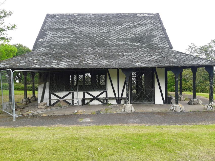
2.2         Green Infrastructure Strategy                                                   Corridor 3 – Blackrock to the Mountains
                                                                                            Blackrock Park – Deerpark – FitzSimon’s Wood – Fernhill Park – rural

The Green Infrastructure (GI) Strategy, Appendix 14 of the Development Plan(2), seeks       This corridor runs between the regional Blackrock Park and the Dublin Mountains.
to provide a vision and a framework to help identify, protect, promote and enhance the      This provides residents or visitors with opportunities to connect from the urban area of
GI assets in the urban, rural and coastal environments of the County, and is intended       the County to the coast or to the mountains.
to guide key aspects of planning policy and County and local level. The benefits of GI
are recognised as being many, such as improving health and wellbeing through new
and improved recreation and better local walking and cycling connections; enhancing            Objectives
social cohesion; protecting, managing and enhancing biodiversity; reinforcing sense
of place, and improving water quality and management. GI can also provide potential            1.        To provide a multifunctional GI corridor connecting the mountain,
economic benefits through enhanced opportunities for tourism and local business                          urban area and the coast.
activities.                                                                                    2.        Enhance the utilisation of FitzSimon’s Wood as a gateway into the
                                                                                                         mountains.
The spatial framework identifies Blackrock Park as forming an integral part of the             3.        To develop Fernhill Gardens into a Gateway Park / Regional Park
costal GI corridors, linking the entire coast of Dún Laoghaire and providing one two
strategic ‘gateway hubs’ into the county.

                                                                                            Corridor 5 – Intra Urban
Corridor 1 – Costal                                                                         Killiney Strand – Kilbogget Park/ Cabinteely Park/ Clonkeen Park –
Shanganagh Park – Killiney Hill – Newstownsmith Park-People’s Park-                         Deansgrange – Blackrock Park
Blackrock Park
                                                                                            The location of the Shanganagh and Deansgrange rivers at Killiney Strand are the
Blackrock Park is a regional park, which is also in a key location for introducing the      starting point for the intra urban Green Infrastructure connection. It also connects
coastal route and connecting with the intra urban and rural corridors.                      with the coastal corridor. This is a corridor rooted in its local community but extends
                                                                                            access to the coast. Significant recreational activity is centred at Kilbogget Park, and
This corridor extends into surrounding counties; Dublin City to the north and               further extension and use of connecting green space will be encouraged with the GI
Wicklow County Council to the south. From a Green Infrastructure perspective the            Corridor status. This GI corridor would utilise the existing green and open spaces to
principal role of this corridor is to connect open space and recreational assets. It also   develop their full multifunctional potential. An established Greenway runs along most
links into many local parks and Greenways and cycle routes. It has four major hubs,         of the corridor, with the Deansgrange River providing a continuity and diversity that
which provide connections with other GI corridors, at Shanganagh Park, Killiney Hill,       can be enhanced by the application of GI techniques. River restoration and opening of
Newtownsmith Park and Blackrock Park.                                                       the river would be prime of example of the GI potential.

       Objectives
                                                                                               Objectives
       1.       To provide a coastal corridor that connects a number of
                regional parks and iconic recreational sites within the 		                     1.        To provide a multi-functional GI corridor connecting the urban
                County and extends into the surrounding administrative                                   area and coast, with links to the mountains via other Corridors and
                boundaries.                                                                              cycle network.
       2.       To improve visitor experience and increase duration of                         2.        Enhancing the urban linear parks adjacent to watercourses with
                stay by providing a wide range of transport options and 		                               fully integrated wildlife and habitat features.
                linkages to a choice of parks.                                                 3.        Reduce flood risk in the downstream reaches of Deansgrange
       3.       To provide a multi-functional GI corridor crossing and 		                                River through attenuation within parks, use of SuDs within the
                connecting the mountain, urban area and coast and linking                                Greenways and Green Streets on local roads leading into the park
                with other corridors.                                                                    areas.

                                                                                                            BLACKROCK PARK | DRAFT SITE ANALYSIS

                                                                                                                            7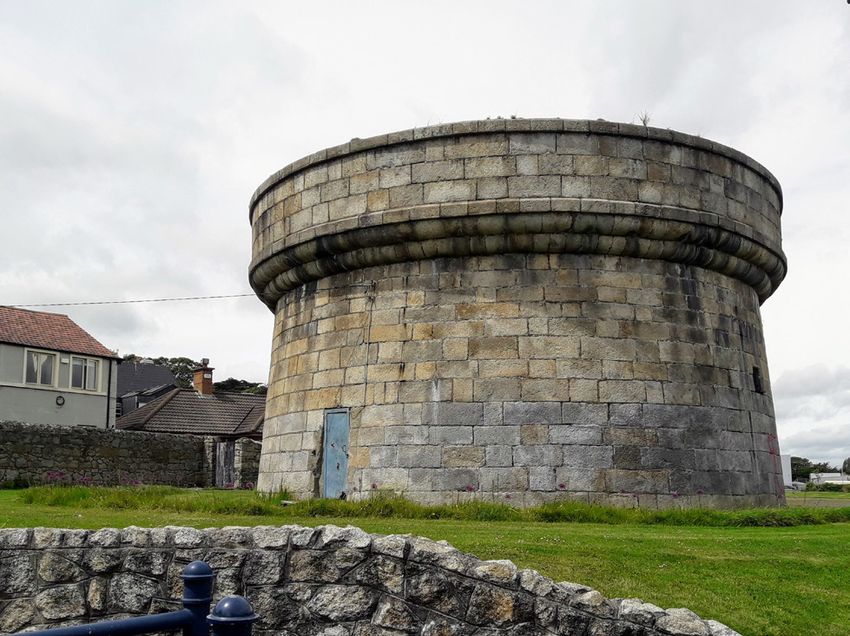
2.3.1 Land Use Zoning Objective 2.3.3 Specific Local Objective: Improved access from the 2.3.5 Flooding
DART Station
Blackrock Park is zoned ‘F’ with a stated objective ‘To preserve There is an ongoing risk of coastal flooding due to high tides and wave overtopping between the West Pier and the County
and provide for open space with ancillary active recreational Map No. 17, BP 1: Boundary at Booterstown. This is likely to increase as the impacts of Climate Change worsen. It is predicted that sea levels
amenities’. COMHAIRLE CHONTAE DHÚN LAOGHAIRE-RÁTH
will rise AN
in Dublin Bay by up to 0.48m by the year 2100 whichDÚIN
will have increase the amount of overtopping and some localised INSETRathgar
Rathfarnham
1
Milltown
Windy
Booterstown
2
Blackrock
Dun Laoghaire
Improved cycle and pedestrian linkages between Blackrock flooding in the Park area. The Railway/DART line will be more frequently inundated and closed due to these flood events and3
Arbour Mount
Merrion
Churchtown
DÚN LAOGHAIRE-RATHDOWN COUNTY COUNCIL
Monkstown
Goatstown
Dundrum Stillorgan
Kill of Glasthule
Uses Permitted In Principle: Park and the DART station to rear of Deepwell - to include a flood alleviation scheme will be required in the short term to protect this critical infrastructure. Any such5scheme may also
Galloping the Grange
Green Deans
Ballinteer
Grange Sallynoggin Dalkey
4
6
Edmonstown
Foxrock
Sandyford
Community Facility(g), Cultural Use(g), Open Space(g), increased width of the existing corridor and upgrading assist with alleviating flooding in the Park. DLRCC will liaise with Irish Rail and also complete any practicable works required
Marley Leopardstown Cornelscourt
7 Killiney
Dalkey Island
Cabinteely
Stepaside
Planning and Organisational
Rockbrook Carrickmines Ballybrack
SportsI nFacility(g),
n o v a t i o nTravellers
D e p a r tAccommodation. of the entrance to Blackrock Park at the location of the to prevent frequent partial inundation of the Park.
Ballyedmonduff
Kilmashogue
Cherrywood
ment Tibradden 8 Tiknock 9 Glenamuck
Laughanstown
10
existing bridge and adjoining stream area in accordance
Loughlinstown
Flood Zone Maps
Kiltiernan
Rathmichael
INSET Shankill
Ballybrack Johnstown
13 Cork
with Objective PC1, Chapter 4. Flood Zone Map (below) shows that parts of Blackrock Park (highlighted in red) are within Flood Zones
11 A and
12 B
Glenadoo Glencullen
INSET Little INSET
Ballybetagh
Barnaslingan
14
Includes Ordnance Survey Ireland data reproduced under OSi Licence Boranaraltry Brockey
INSET
Old
2.3.2 Uses Open For Consideration:
number 2013-2015/CCMA/Dun Laoghaire-Rathdown County Council. INSET Connaught Bray
Ballyman
Unauthorised reproduction infringes Ordnance Survey Ireland
INSET
Glencree
and Government of Ireland copyright.
2.3.4 Other Objectives identified: BP6
Enniskerry
© - Ordnance Survey Ireland, 2016
INDEX
Allotments, Car park(g), Cemetery, Craft Centre/
Craft Shop(f), Childcare Service(f), Crematorium(g), It is an objective of the Council to upgrade the landscaping
Education(g), Garden Centre/Plant Nursery(g), Golf and public realm around to the Pond and Amphitheatre area
Facility(g), Guest House (f), Place of Public Worship(g), and to improve the hydrological environment of the Pond.
Public Services, Tea Room/Café(g). The existing pond edge and footpaths shall be upgraded and Hotspots
repaired, while the tidal inflow/outflow which previously
Hotspots Predicted
f: In existing premises self cleaned the pond are to be reinstated and improved.
Flood Zone A
Renovations to the pond area will promote and enhance the
Flood Zone B
g: Where lands zoned F are to be developed then: Not biodiversity value of the island, while the fountain feature
more than 40% of the land in terms of the built form and shall be restored. The existing amphitheatre will be enhanced
surface car parking combined shall be developed upon. Any to improve access. A small area of the lake, below the existing
built form to be developed shall be of a high standard of amphitheatre will be converted to an enlarged stage, lawn and
design including quality finishes and materials. The owner improved circulation area
shall enter into agreement with the Planning Authority
pursuant to Section 47 of the Planning and Development
Act 2000, as amended, or some alternative legally binding
agreement restricting the further development of the
remaining area (i.e. 60% of the site) which shall be set
aside for publicly accessible passive open space or playing
fields. Said space shall be provided and laid out in a manner
designed to optimise public patronage of the residual open
space and/or to protect existing sporting and recreational
facilities which may be available for community use. Flood map (above) illustrates a 1 in 1000 year flood of Blackrock Park
1916 Memorial Garden, Blackrock Park
BLACKROCK PARK | DRAFT SITE ANALYSIS
8
0 0.1 0.2 0.3 0.4 0.5
Kilometres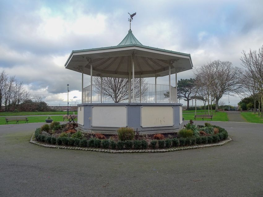
2.4      Relevant Policies taken from the Dún Laoghaire Rathdown County Development Plan 2016-2022 & Blackrock Local Area Plan 2015-2021

The site analysis and feasibility study of Blackrock Park will tie in with the relevant   open space provision in Dún Laoghaire-Rathdown. This culminated in the                    Authority to be of special architectural, historical, archaeological, artistic, cultural,
national and regional policy as outlined in the County Development Plan 2010-             publication of the Open Space Strategy for the County, for the period 2012-2015.          scientific, technical or social interest in the Record of Protected Structures (RPS).
2016 as well as the following specific policies;                                          The actions and recommendations detailed in the Strategy will be implemented as           ii.         Protect Structures included on the RPS from any works that would
                                                                                          appropriate and as resources allow.                                                       negatively impact their special character and appearance.
Section 4.1.2.1 Policy LHB2: Preservation of Landscape Character Areas:                                                                                                             iii.        Ensure that any development proposals to Protected Structures, their
It is Council policy to continue to preserve and enhance the character of the             Section 4.2.2.2 Policy OSR3: Hierarchy of Parks and Open Spaces                           curtilage and setting shall have regard to the Department of the Arts, Heritage
County’s landscapes in accordance with the recommended strategies as originally           It is Council policy to provide a hierarchy of quality parks and public open spaces       and the Gaeltacht ‘Architectural Heritage Protection Guidelines for Planning
outlined in the landscape Character Assessment (2002 and since updated), in               which vary in size and nature and are designed to serve the needs of all members          Authorities’ (2011)
accordance with the ‘Draft Guidelines for Landscape and Landscape Assessment’             of the community, including people with mobility impairments, by being readily            iv.         Ensure that new and adapted uses are compatible with the character and
(2000) as issued by the Department of Environment and Local Government, in                accessible and at a convenient distance from their home and/ or places of work.           special interest of the Protected Structure.
accordance with the European Landscape Convention (Florence Convention) and
in accordance with ‘A National Landscape Strategy for Ireland – Strategy issue            Section 4.2.2.3 Policy OSR4: Future Improvements                                          Section 6.1.3.3 Policy AR3: Protected Structures and Building Regulations
Paper for Consultation’ 2011.                                                             It is Council policy to continue to improve, landscape, plant and develop more            It is Council Policy to protect the character and special interest of Protected
                                                                                          intensive recreational and leisure facilities within its parks and open spaces insofar,   Structures when considering or carrying out intervention to comply with the
Section 4.1.2.5 Policy LHB6: Views and Prospects:                                         as resources will permit, while ensuring that the development of appropriate              requirements of the Building Regulations – with particular reference to Part B and
It is Council policy to protect and encourage the enjoyment of views and prospects        complementary facilities does not detract from the overall amenity of the spaces.         Part M.
of special amenity value or special interests.
                                                                                          Section 4.2.2.6 Policy OSR7: Trees and Woodland                                           Section 6.1.3.5 Policy AR5: Buildings of Heritage Interest
Section 4.1.2.16 Policy LHB17: Trails, Hiking and Walking Routes                          It is Council policy to implement the objectives and policies of the Tree Strategy for    It is Council policy to:
It is Council policy to promote the development of regional and local networks of         the County – ‘dlr TREES 2011-2015’ - to ensure that the tree cover in the County is       i.          Retain where appropriate, and encourage the rehabilitation and suitable
hiking and walking routes and trails.                                                     managed and developed to optimise the environmental, climatic and educational             reuse of existing older buildings/structures/features which make a positive
                                                                                          benefits which derive from an ‘urban forest’.                                             contribution to the character and appearance of a streetscape in preference to
Section 4.1.3.1 Policy LHB19: Protection of Natural Heritage and the                                                                                                                their demolition and redevelopment and to preserve surviving shop and pub fronts
Environment                                                                               Section 4.2.2.7 Policy OSR8: Greenways Network                                            of special historical or architectural interest including signage and associated
It is Council policy to protect and conserve the environment including, in particular,    It is Council policy to develop a comprehensive network of County Greenways               features.
the natural heritage of the County and to conserve and manage Nationally and              linking parks and public open spaces and to liaise with adjoining local authorities       ii.         Identify buildings of vernacular significance with a view to assessing them
Internationally important and EU designated sites - such as Special Protection            and other stakeholders to achieve and improve wider external linkages and                 for inclusion in the Record of Protected Structures.
Areas, candidate Special Areas of Conservation, proposed Natural Heritage Areas           corridors.
and Ramsar sites - as well as non-designated areas of high nature conservation                                                                                                      Section 6.1.3.6 Policy AR6: Protection of Buildings in Council Ownership
value which serve as ‘Stepping Stones’ for the purposes of Article 10 of the Habitats     Section 4.2.2.9 Policy OSR10: Provision and Promotion of Recreational                     It is Council Policy to continue to demonstrate the best practice with regard to
Directive.                                                                                Facilities                                                                                Protected Structures, Recorded Monuments and often elements of architectural
                                                                                          It is Council policy to provide sporting and recreational amenities of both an            heritage in its ownership and care.
Section 4.1.3.3 Policy LHB21: Biodiversity Plan                                           indoor and outdoor nature. It is the policy of the Council to promote participation
It is Council policy to implement the provisions of the County Biodiversity Plan          in sport and leisure activities among all residents of the County. The Council will       Section 6.1.3.7 Policy AR7: Energy Efficiency of Protected Structures
2009-2013 and to produce a second Biodiversity Plan which will be set within the          endeavour to promote the increased use of these facilities and of the excellent           It is Council Policy to have regard to the Department of Environment, Heritage and
context of the second National Biodiversity Plan, ‘Actions for Biodiversity, 2011 –       natural resources located throughout the County. The Council will endeavour to            Local Government’s publication on ‘Energy Efficiency in Traditional Buildings’
2016’ prepared by the Department of Arts, Heritage, Gaeltacht and the Islands             ensure access to sporting infrastructure to meet the needs of the community in any        and any future advisory documents in assessing proposed works on Protected
                                                                                          major new residential developments.                                                       Structures.
Section 4.2.1.1 Policy OSR1: Green Infrastructure Strategy
It is Council policy to protect existing green infrastructure and encourage and           Section 4.2.2.13 Policy OSR14: Play Facilities                                            Section 6.1.3.9 Policy AR9: Protection of Historic Street Furniture
facilitate, in consultation with relevant stakeholders, the development of new            It is Council policy to support the provision of structured and unstructured play         It is Council Policy :
green infrastructure, recognising the synergies that can be achieved with regard to       areas with appropriate equipment and facilities throughout the County and to              i.          Preserve the retention of historic items of street furniture where these
the following, sustainable transport, provision of open space amenities, sustainable      ensure the needs of all age groups and abilities - children, teenagers, adults and                    contribute to the character of the area including items of vernacular or
management of water, protection and management of biodiversity and protection             older people – are facilitated in the public parks of Dun Laoghaire- Rathdown.                        local significance.
of cultural and built heritage.                                                                                                                                                     ii.         Promote high standards for design, material and workmanship in public
                                                                                          Section 6.1.3.1 Policy AR1: Record of Protected Structures                                            realm improvements within areas of historic character.
Section 4.2.2.1 Policy OSR2: Open Space Strategy 2012-2015                                It is Council policy to:
In 2009 the Council prepared a comprehensive audit of the existing and proposed           i.       Include those structures that are considered in the opinion of the Planning

                                                                                                                     BLACKROCK PARK | DRAFT SITE ANALYSIS

                                                                                                                                     9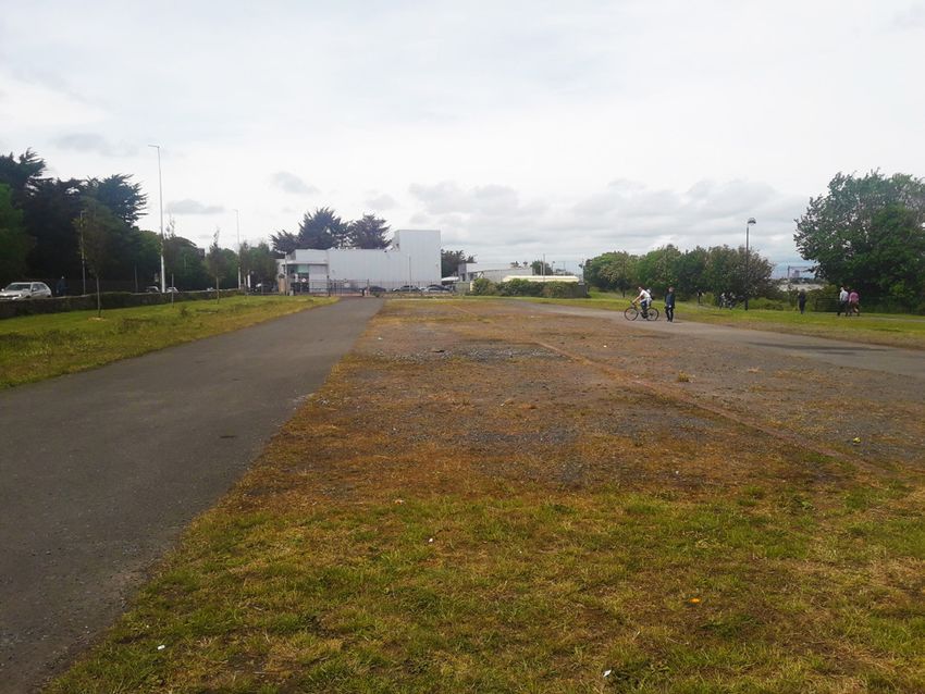
The circular hardstand area which surrounds the structure        Willow and Hornbeam. The new arrangement has caused

                                                          03
                                                                                                                                              was upgraded at the same time and this work also included        the loss of views between the bandstand space and Elm
                                                                                                                                              the replacement of the cast iron benches. There are several      Cliff.
                                                                                                                                              early mature trees including Lime, Sycamore, Weeping

                               EXISTING ARRANGEMENT

   3.1       Site Location and Context

Located on the edge of the municipal area it straddles the      The park features strongly defined edges formed by
urban and suburban threshold. It is a key, strategically        adjacent infrastructure and the built environment. The
located park as it is situated in the intra urban area          park is 8 km from the city centre and 4km from Dun
adjacent to the coast. For this reason it is highlighted in     Laoghaire town.
the green infrastructure strategy as a key gateway as part of
a coastal route and as a coast to mountains route.
                                                                                                                                                           View of the renovated bandstand in Blackrock Park

3.2.1     Park Features

3.2.1.1   Pavilion & Bandstand

The heritage southern end adjacent to the village is            the east of the main entrance on Rock Hill. This entrance
considered the heart of the park. This area contains the        features a cut granite lintel & pedimented detail with the
strongest Victorian influence, the greatest accumulation        words ‘To the Railway’ printed on it. A network of steps and
of features and the most engaging topographical character.      ramps connect to the lower area of the park. The change in
The entrance opposite the bottom of Merrion Avenue              level creates a dramatic feature out of the Priory Stream
features an imposing set of 5no. granite piers featuring        which flows beneath the Rock Road and into the park.                                                                                                      View of granite piers featuring Beux Arts details

Beux Arts details as well as substantial gates and historic     The stream forms a cascade as it travels towards the sea.
metalwork.                                                      At this point it is railed off for safety. The banks flanking
                                                                the paths and ramps have been recently renovated. The
An unused toilet pavilion flanks the entrance on the right      mix of woody shrubs has been replaced with sweeps of                                                 View of disused kiosk pavilion

of the entry. The block features rendered blank facades         herbaceous planting.
with clerestory windows on each side. The roof cantilevers
over the Rock Road footpath forming a canopy which              A haphazard collection of buildings at the bottom of the
marks the entrances into the separate toilets.                  slope form a visual and physical impediment between the
                                                                slope and the bandstand space. This collection is made
Positioned in the centre of the elevated space, a pavilion      up of 2 temporary type structures and a bunker type
dominates the area and creates a focal point. Its centralised   permanent building. A set of steps leads onto a concrete
location exploits the view of the bay and creates a visual      bridge which traverses the stream and onto a path which
connection with the bandstand below. The kiosk was built        hugs the boundary wall. A T-junction at the end of this
sometime in the mid 1890’s and functioned as a sweet and        path leads right down a lane to Blackrock DART Station.                                                                                         View of lane into park from Blackrock DART station, behind Deepwell
cake shop. It is constructed in a half-timbered style with
a bonnet type roof. The outer perimeter of the roof forms       The lower space is centred around the bandstand. This
a veranda sheltering fitted timber benches. Structures of       structure was recently renovated which involved the
this kind were popular in parks at the time.                    replacement of the copper roof. The circular hardstand
                                                                area which surrounds the structure was upgraded at the
                                                                                                                                                                 ‘To the Railway’ entrance on Rock Hill
An additional pedestrian entrance is located further to         same time.

                                                                                                                    BLACKROCK PARK | DRAFT SITE ANALYSIS

                                                                                                                                   10
3.2.1.2 Lake and carparking 3.2.1.3 Williamstown & Booterstown
The lake is the dominant feature within the park. The the park and acts as a link in a broader commuter corridor. The view north along this space is terminated by the and an enclosing footpath. A playground at the northern
shape is organic in outline punctuated with a tree covered Martello Tower. This structure conveniently acts as a end of the space is flanked by lines of trees. To the north of
island. A pump house disguised as a historic folly is nestled The carpark at Phoenix Terrace caters for 18 cars. It halfway marker along the length of the park. Adjacent to the playground a line of early mature beech trees defines
amongst the vegetation. This unique saline lake features a features an entry and an exit gate. These gates feature the Martello tower there is a pedestrian access point which this space and separates it from the rest of the park beyond.
rusticated edge and is enclosed by a perimeter pathway. similar imposing granite piers and substantial original links with the bridge across the DART line. At the end of This area is characterised by its porous boundary onto the
The most unusual aspect of the lake is the circular island metalwork to the entrance at Elm Cliff. Access paths from Martello Terrace there is a locked entrance. This entrance Rock Road. It features three identical entrance points.
stage at the northern end. This feature is part of a grass the carpark lead to a 1916 memorial garden and towards features a fine set of cut granite piers and a set of wrought Each entrance contains two benches opposite eacht other
amphitheatre that encloses the northern end of the lake. the eastern side of the park to the cycle/walking route that iron gates. The stretches of wall at this point are well and a stepped access point into the park.
Its bank rises sharply in level from the lake to the Rock parallels the railway line. An ESB substation sits jarringly constructed granite random rubble with worked capping.
Road. A path runs along this bank ramping up to provide along the boundary with the railway line opposite this Beyond the Martello tower there are several hardstand Beyond the line of beech trees a sunken area is laid out
access with the Phoenix Terrace carpark. A utility box and path. Additional space is occupied by the substation which spaces. The two immediately north of the Martello Tower with a formal arrangement of narrow paths. This is the
a commemorative seat are incongruously located along provides parking for service vehicles. The area known as are a disused 5 a side soccer pitch and tennis court. Further remnants of a garden designed and built in the 1980’s. The
this path. A historic stone structure which resembles a Williamstown is a large featureless space that backs onto north there is a larger abandoned, temporary carpark sunken area is flanked on its northern edge by another
lookout post sits inconspicuously below the Rock Road the residential developments of Phoenix Square, Emmet area. Beyond this, the park pinches behind a cluster of line of trees. The space between the DART station and
amongst the trees. This may have served as a changing Square and Seafront Parade. A grove of trees is the only buildings, including a car showroom. At this point the the trees is a non-descript expanse of grass. The walking
facility before the construction of the railway line. On the feature in this space. It is made up predominantly of Lime path is squeezed between the marsh and a boundary wall. cycling route runs parallel with the Rock Road and exits/
other side of the lake, along the eastern edge, the path but there are also Poplar and Ash. To the further side of this the park once again tapers out. enters at the north west corner. This entrance interfaces
doubles as a cycle path. It is the main access route through poorly with the wider public realm. It features a jarring
This area features an expansive grass area flanked by trees collection of utilities, bollards, barriers and steps.
View of saline lake and DART line in the background View of disused temporary carpark beside the car showroom View of the disused Martello Tower View from the 1916 memorial garden towards Williamstown
(Booterstown)
BLACKROCK PARK | DRAFT SITE ANALYSIS
113.2.1.4 Existing Views & Prospects
The selected views and prospects across Dublin Bay from Blackrock Park. As per policy LHB6 of the Dún Laoghaire Rathdown County Development Plan 2016-2022 ‘It
is Council policy to protect and encourage the enjoyment of views and prospects of special amenity value or special interests’.
1
2
View towards Booterstown Marsh View towards Poolbeg and Great South Wall
3
4
View towards Dublin Bay View towards Dun Laoghaire Harbour
1 2
5
3 4
5 LEGEND
View over Blackrock Park toward Howth
BLACKROCK PARK | DRAFT SITE ANALYSIS
124.3 Setting Out Blackrock Park
04 Blackrock saw continued development during 19th
century. This created a need for local amenities. The
of the bandstand and tree planting continued for several
years into the 1890’s. The park was not “fenced” until 1909.
proposal to build a park on the landlocked site originated The 25 inch map (1888-1913) confirms that the majority
in 1871. Representatives from Blackrock Township met of the park features are located at the Blackrock end of
HISTORICAL CONTEXT with Dublin, Wicklow, Wexford Railway Company. the park. Beyond Williamstown and the Martello Tower
The land was owned by Lord Pembroke and he offered there is a clear lack of any park infrastructure. There are
the site to the Township on the condition that it was no paths depicted with the only feature being a line of
developed as a public facility. The tidal nature of the site trees along the edge of the Rock Road.
4.1 Village & Railway line
and the technical difficulties in reclaiming slobland were
considerable. The City Engineer, Bindon Blood Stoney, Notable additions to the park over the years include the
There is a documented settlement in Blackrock as far Dublin bay is apparent from the map.
synonymous with the construction of the quay walls along amphitheatre, designed by Luan Cuffe and built in the
back as Medieval times. The area was a fishing village that
the Liffey, had drafted up the plans and specifications for early 1960’s. A playground, installed in the late 1990’s,
developed as a seaside resort during the 18th Century. 1834 saw the completion of the Dublin and Kingstown
the park. The works began in 1875 and were completed in adjacent to the bandstand and a newer playground
The shoreline was further inland facilitating easy access railway line. The project was conceived as a way of
October 1879. close to the entrance at the Booterstown end. A carpark
to the bay for the local community. Buff granite is the connecting the city centre with the newly constructed Dun
at Phoenix Terrace was added in the late 1990’s and a
predominant rock in the local area and this helps to Laoghaire Harbour. This was the first commuter train line
There were several delays due to the challenging nature hardstand area to function as a temporary carpark/event
explain the name of the village which is derived from an in the world and it had a profound effect on the population
of the site as well as shortages in funding. Lord Pembroke space was constructed in 2010. Other elements include
outcrop of limestone situated near to the shore, becoming as well as the settlement patterns along the coastline of
stepped in on several occasions to provide incentive for the formal Italian garden adjacent to Booterstown DART
black when wet. John Rocque’s map dating from 1799 the county. The train line improved accessibility between
the completion of the park. He leased Elm Cliff to the station designed by Dennis Shannon.
depicts a landscape with a dispersed, low density pattern Blackrock and the wider metropolitan area. It was a catalyst
park for a low fee for 200 years. The purpose of this was to
of large estate houses and associated curtilage as well as a for the nucleated development patterns which occurred
annex it to the park and create a formal entrance opposite During the late 1970’s, a parcel of land along a narrow
light network of roadways. An early layout of the town is during the 19th Century and marked the beginnings of the
the bottom of Merrion Avenue. Elm Cliff had been a strip of the park, opposite Blackrock College, was sold and
identifiable and a close association with the coastline and sprawling suburban settlement patterns present today.
private residence and the 6 inch map depicts a property developed as a car showroom. The site was extended to the
4.2 Coastline directly opposite Merrion Avenue close to the Rock Road. rear during the mid 1990’s to accommodate a permenant
The property was demolished to make way for the large traveller settlement.
The route of the Dublin and Kingstown railway line hugs the south Dublin coast. This costal route offered a consistent park entrance.
gradient and a direct line between Dun Laoghaire and the city centre. Dispute with 2 major landowners over the The scale of this development has created a physical and
acquisition of land along the proposed route resulted in large compensation and in the case of Lord Cloncurry, the The park was known as “The People’s Park”, a designation visual impediment in the park isolating the Booterstown
construction of a private culvert, bridge and pavilion to access his bathing spot on the coastline. This ornamental popular at the time. The work on the park continued for end from the rest of the park.
bridge structure is a landmark along the DART route today. several years with the addition of rockeries, the erection
This coastal route had a direct and emphatic impact on the Blackrock coastline. It severed the village and local area
from the bay. The most dramatic transformation of the coastline occurred along the stretch extending between
Merrion and Blackrock. The construction of the tracks on an embankment offset from the shoreline further into
the bay created a landlocked space that subsequently became a coastal wetland. The 6 inch map (1837-1842) lists the
space as “Flooded at Hightides”. Several culverts through the railway embankment can be seen between Blackrock and
Booterstown railway station.
This f looding at high tide created a safe and convenient bathing amenity for local people. The 6 inch map (1837-1842)
depicts several bathing spots with separate facilities for ladies and gentleman. Conversely, at low tide, the area was a
dreary, unusable piece of slobland as can be seen at the Booterstown marsh today. Blackrock was becoming a wealthy
middle class suburb and the marsh would not have agreed with the Victorian sensibilities of manicured and neat
landscapes.
View of lake in Blackrock Park c.1905 Historic image of the train line
BLACKROCK PARK | DRAFT SITE ANALYSIS
134.4 Broader Landscape
A study of the broader landscape through the historic electrified by 1901. The original concept of the tramway
maps shows the accelerated development of the local network was to link all the major city train stations. At
area. What was a collection of dispersed large estate lands its peak, the system was known as technically innovative,
depicted in the 6 inch map (1856) had transformed into and was described in 1904 as one of the most impressive
the suburban settlement pattern as seen today by the 25 in the world.
inch map (1888-1913).
Another feature of note in the local area is the Public
The other notable development evident on the 25 inch Baths. In 1839 the railway company provided a public
maps is the tramline shown running through the main bathing area known as Blackrock Baths. In 1887, the Baths
street of Blackrock Village and around the outside of the were rebuilt in concrete. The Baths comprised of a sea-
park along the Rock Road. This route was the Dalkey to pool, multi-height diving board and public seating. The
O’Connell Street tramline. The presence of the train and Urban District Council acquired the Baths in 1928 and
tramline would have provided easy access from the city they operated until the late 1980’s. The baths were in close
and surrounding areas to Blackrock Park. The completion proximity to the park and were a complimentary public
of the park coincided with the electrification of the tram facility, encouraging footfall and helping to establish
system. The first tramlines were in operation in 1872, a collection of destination points within the town. This
they were horse drawn with the network becoming fully would have benefitted local traders and businesses.
Historic 6” map 1837-1842
View of Blackrock Village c.1875 View of Blackrock Village c.1900
4.5 Martello Tower
Fortunately, the alignment of the Dublin & Kingstown halfway point along its length. Over the years it has been
train line swept around the seaward side of the South 15 a private residence, used as commercial premises and as
Williamstown Martello Tower. This has protected it from sports clubhouse. The squat appearance of the building is
coastal erosion over the last 200 years. It was constructed a result of the major changes in the ground levels with the
in the inter-tidal beach area which could have made it construction of the train line and the development of the
vulnerable to undermining and damage. The Martello park. A large proportion of the building is now submerged
Towers are iconic structures along the Dublin coastline. in the park.
Historic 25” map 1888-1913
The tower is a great addition to the park and marks the
BLACKROCK PARK | DRAFT SITE ANALYSIS
145.2.1 A man-made Coastline
05 The geography of the park has been heavily
inf luenced by manmade interventions. There
is a unique and direct relationship between the
As detailed in the previous chapter,
construction of the railway line had a direct,
transformative effect on the
the
geographical
local geography and history. An examination of character of the coastline. The landlocked area
GEOGRAPHICAL CONTEXT Rocque’s “Exact Survey of the City and Suburbs of created by the route of the railway between
Dublin“(1756) highlights Blackrock as a bathing Merrion Gates and Blackrock village created
destination. Men’s and women’s bathing shelters a saltwater marsh. The entire area would have
5.1 General
are described. The area occupied by Blackrock resembled Booterstown Marsh as it exists today
Blackrock Park is a linear urban coastal park nestled on the land rises steadily from the coastline to its highest point of approx. Park is called “Blackrock Lake” and the map but the majority of the area was filled in during
southside of Dublin Bay. It is approximately 4km from Dun 87m above sea level which is at the junction between the N11 and depicts the space as covered in rock outcrops the creation of Blackrock Park. The loss of
Loaghaire Harbour and 9km from Dublin city centre and comprises Newtownpark Avenue at White’s cross. The area is characterised by which are typical of the local coastline. The high connection with the bay and the coastline for the
of green spaces, running for 1.3 km between the Rock Road and its low rise suburban collection of housing estates. The majority of water mark is also included and this is indicated local community has been an unfortunate result
the railway line. The total area of the park is 14 hectares in size the housing is made up of two storey dwellings with front and rear along the edge of what is now the Rock Road, of the railway line.
stretching from Blackrock Town Centre to Booterstown Marsh. gardens. The low density sprawl is the result of the relatively large continuing on to Butterstown (Booterstown).
plot sizes as well as the generous provision of local green spaces. The concentration of settlement, at what is now
The area defined as Blackrock extends from the Punchbowl pub Blackrock village is the main retail area. The area is serviced by Blackrock main street, sits right on the coastline.
and Booterstown Road in the north, to Monkstown & Kill Lane in several primary, secondary and third level educational facilities.
the South and the N11 marks the boundary on the western edge. The
5.2.2 Dublin Bay
C The view from the pavilion at Elm Cliff in the Williamstown Martello Tower highlights the
Park captures a striking vista. The sea including strategic location of the area. The park occupies a
the great south wall and the city skyline is all spot which sits almost at the crux of the southern
A B set against the backdrop of the rising headland bay. It is half way between the rivers estuary at the
of Howth Head beyond. It gives a great sense of south wall and the peninsula of Dun Laoghaire
the shape and scale of the bay and puts Blackrock harbour.
Park in the context of the broader county. The
3.0
2.0
1.0 KM
KM
KM
D
View north towards Howth Head View southeast towards Dún Laoghaire Harbour
A. Poolbeg Chimneys B. Great South Wall C. Howth D. Dún Laoghaire Harbour
BLACKROCK PARK | DRAFT SITE ANALYSIS
155.3 Straddling the Municipal Boundary 5.5 East/West movement
Blackrock Park is classified as a Gateway Park in the The municipal boundary is located close to Merrion Gates Generally, the land rises up moving west towards Carysfort Avenue, Newtownpark Avenue and Kill Lane.
DLR Green Infrastructure Strategy (2016-2022). It is also which is a natural pinch point and threshold. the Dublin Mountains. The main east west routes Dublin and the broader metropolitan area have evolved
acknowledged as occupying “a key location for introducing are composed of minor roads classified as local. The with a series of radial approaches to the city centre.
the coastal route and connecting with the intra urban and The ribbon of spaces made up of the vacant land north of exception is Merrion Avenue which forms part of the main Orbital routes running around the circumference of the
rural corridors.” Within the Strategy it is an important the marsh, Booterstown Marsh and Blackrock Park mark national route connecting Dún Laoghaire Harbour with city are less conducive to movement. Between the N11 and
element of the proposed Corridor 1-Coastal route. It is a a transition from the built up character of the city into the city centre and onto the M50. The N11 on the western R118 are a network of local routes serving the collection of
gateway and threshold between the urban district of Dublin the greener suburbs. The campus of Blackrock college also edge of the area and the Coast Road (R118) are connected residential estates.
City and the coast and hills of Dun Laoghaire Rathdown. helps to reinforce this change of character. with several minor roads including Booterstown Road,
ROCK ROAD
BLACKROCK PARK
RAIL
MOUNT MERRION AVENUE
N31
Proximity of main transportation routes to Blackrock Park 5.6 Blackrock Village
5.4 North/South movement Rock Road & Railway Blackrock Village is immediately adjoining Blackrock week day commutes. The construction of Blackrock (1984)
Park along its southern boundary. A laneway connects and Frascati (1985) shopping centres created a new type
The primary movement runs in a north/south direction corralled The train line was built in the 1830’s and exploited the f lat
the DART station and the park which runs along the rear of urban dynamic in the village. These shopping centres
by the coastline to the east and the rising landscape to the west. character of the shoreline in the bay. The 6“ map (1837-1842)
boundary of a large private property called Deepwell. A were successful in their own right but at the detriment to
This carriageway route follows the coastline and maintains a (Refer to Chapter 04 Historic 6” map 1837-1842) includes the recently
fine pedestrian entrance at the western end of the main the main street and the small local businesses. Blackrock
relatively f lat topography. It is a historic thoroughfare which completed railway route. It connected the new commuter town
street connects the village with the south west corner of shopping centre has had an enduring, negative impact
has served the local community and formed part of a larger of Dún Laoghaire as well as the harbour with Dublin city. The
route over the centuries. Dalkey was founded by the Vikings the park. as its external elevation offers no vitality to the day to
25-inch maps (1897-1913) depicts the now defunct tram line.
in the 10th century. A harbour was established there which Tramways were the main transport infrastructure in the city at
day life of the village. Blank facades, tall elevations,
became one of the major ports serving Dublin. The coast road that stage. The tramline is labelled along the Rock Road and two The village has seen a f luctuation in vitality over the years. carpark entrances, vast surface carparking have all had an
connected Dalkey with the city. Rocque’s map (1756) depicts lines are clearly visible running both north and south. Today, From a sleepy seaside village during the 18th century to adverse impact on the local built environment. The dual
the line of the Rock Road as it appears today. This route is well the dominant mode of travel is via private car. The Rock Road a bustling commuter suburban settlement in the 19th carriageway while catering for trips in and out of the city
serviced by bus services currently is shared by both public bus services, private cars and bicycles. century. The 1960’s saw the car become the dominant mode centre has created a large obstacle that has isolated the
of transport. The expansion of the Frascati road in the village from the surrounding expanding suburbs.
1960’s helped to cater for vehicle based shopping trips and
BLACKROCK PARK | DRAFT SITE ANALYSIS
1606
S.W.O.T ANALYSIS
6.1 STRENGTHS 6.1.4 Transport & Movement
Ideally located, with transport corridors punctuating its east and west
6.1.1 Location thresholds. It is neatly bookended with Booterstown DART Station to the
north and Blackrock Station to the south. The Rock Road is the major
The park occupies a location that benefits from its immediate
north/south traffic corridor in the local area and is serviced by the 7 and
proximity to both the coastline and the urban centre of
7a bus routes. The main cycle/ footpath route through the park serves as a
Blackrock. Bus Stop
link in a wider commuter corridor.
Train Station
6.1.2 Paths & Circulation 6.1.5 Linear character
The park benefits from a diverse network of paths providing a Characterised by its linear shape, it varies from the other f lagship parks
range of experiences. They exploit the changes in level to offer within Dún Laoghaire Rathdown. This gives Blackrock park a unique
expansive views of Dublin Bay and contrasting experiences character within the municipality. On a strategic level, the linear green
through enclosed intimate spaces in the park. space forms a section of a future greenway that could circumnavigate
Dublin Bay.
6.1.3 Views 6.1.6 Historic Features
The long views in a northern direction towards the elevated Containing a large range of historic features and details, Blackrock Park
parts of Dublin and Dublin Bay are one of the main assets of has several layers of history that can be clearly read in the landscape.
the park. Its location further benefits from some of the most
B The park is a fine example of Victorian landscape design with features
impressive views within Dún Laoghaire Rathdown.
including, and not limited to, the bandstand and pavilion. The Martello
Tower is one of the most prominent and oldest built features in the park.
A: Views towards Howth Head A
B: View towards the Dublin Bay & Great South Wall Other more inconspicuous surviving details such as railings, gates and
C: View towards Dún Laoghaire Harbour stonework provide a rich historic narrative.
C
BLACKROCK PARK | DRAFT SITE ANALYSIS
176.2 WEAKNESSES
6.2.3 Pedestrian permeability
6.2.1 Boundaries & Entrances
The Rock Road (R118) is a major traffic corridor. It is classified as a regional
The southern section of the park between Phoenix Terrace and road, but this belies the scale of the carriageway, up to four lanes in some
Blackrock Village features a strong boundary with impressive heritage sections, and traversed by large volumes of traffic on a daily basis. The road
entrances featuring original ironwork. This contrasts with the northern creates an intimidating obstacle between the park and the main bulk of
Williamstown parish section of the park where the boundary and the local residential catchment. At present, there are 3 signalised crossings
entrances are a poorly conceived mix of haphazard elements. The issue along the entire 1.2km stretch of the park on the Rock Road. There is an
is compounded by a couple of key factors. The site is completely porous improved crossing at the bottom of Merrion Avenue, with other signalised
from Booterstown DART station to College House, opposite Blackrock crossings at Blackrock Clinic and Booterstown junction. This equates to a
College. This section is approx. 350m long and there are 6 individual pedestrian crossing every 600m. In it current arrangement; the Rock Road
Ununified porus park edge
entrance points. This proliferation is completely undermined by the fails to provide a safe and conducive pedestrian/walking environment as
general porous nature of the boundary. There are short sections of solid per Section 4.3.2 Pedestrian Crossings of the Design Manual for Urban
Heritage boundary
masonry wall, but the boundary is predominantly made up of bollards Road and Streets.
and individual barriers.
The interface between Blackrock Park and the town is weak. The large
At the broader scale, the interface of the park boundary with the Rock entrance at the bottom of Merrion Avenue is impressive but it is isolated
Road is broken by buildings at several points. from the footfall around the town. The smaller Railway entrance is closer
but features a precarious set of historic steps. Access to the park from
There is a general lack of coherence along the entire boundary of the Blackrock DART station is via a narrow, isolated laneway to the back
park. At the time the park was built, the construction was concentrated of Deepwell. At 1m wide this laneway currently cannot accommodate
in the Blackrock section of the park with the Williamstown parish being wheelchairs, buggies, cyclists and pedestrians simultaneously.
left as open space (See section 6.4.2) This has had the adverse effect of
diminishing any sense of presence or feeling of arrival at an important,
f lagship park. 6.2.4 Park Facilities
Generally, Regional Parks provide a wide and varied vistor facilites, such
as public toilets, regional playgrounds, tearooms and active and passive
recreation opportunities. As is evident in other DLRCC Regional Parks
(Marlay, Cabinteely, Killiney, People’s Park). In Blackrock Park there is a
6.2.2 Railway Line clear absense of these facilites at present.
The railway line was the catalyst for the creation of the park. Unfortunately,
it is the railway line that creates a physical barrier between the park and
the coastline. The overhead line infrastructure is also a visual intrusion
when attempting to view the bay from the park.
6.2.5 Lack of Identity
The existing protective boundary fencing and safe overpass crossings
provided by Iarnród Eireann are ulitarian in design and detract from the At present, the park suffers from a lack of identity as it has no public
heritage granite tidal walls and costal vista from within the park. building or congregation point at its centre. There is no amenity providing
food & drink or a facility for people to meet and linger. A public park of
this scale needs to offer more as a destination point.
BLACKROCK PARK | DRAFT SITE ANALYSIS
186.3 OPPORTUNITIES 6.3.4 Tree Planting and greening
The park is endowed with a generous proportion of open grass space,
6.3.1 County Boundary however, the opportunity to accommodate field sports is not feasible
due to its dimensions and topography. Currently, there is a greater
Blackrock Park is defined as a strategic ‘Gateway Park’ in the Green emphasis on passive recreation in Blackrock Park and this can be
Infrastructure Strategy (GIS). There are 6 strategic, green corridor underpinned by improving the nature value. In the context of Climate
routes proposed in the GIS and Blackrock Park forms part of 3 of Change and carbon offsetting, Blackrock Park has the potential to
these (See 2.2). This highlights the importance of the park and its key, contribute to the greening of the County through tree planting. This
geographic location on the threshold between the city and the suburbs. would have multi-faceted benefits for the local population and the
It is a starting/ finishing point on three of the routes including a coastal, health of the bay.
estuarine and mountain route. The Dublin Bay Trail cycle route can
also be factored into the conf luence of important routes. A focal point The wetland areas are a unique feature of the park. There is a mosaic
such as a pavilion or an information hub would act as an anchor and a of habitats including the stream, woodland, open grassland, lagoon
destination point for park users. and the large salt water pond. Each of these supports wildlife. There is
great potential to develop thriving habitats while facilitating increased
Straddling the county boundary, Blackrock Park is strategically located footfall in the park.
to create a powerful entry point into Dún Laoghaire Rathdown.
Approaching from the city centre, an arrival into the municipality
6.3.5 Interface with Blackrock Town
should be a transition from an urban setting into a nature rich, greener
landscape. A sense of your location in close proximity to Dublin Bay is
The park and town have the potential to benefit from improved
important.
connections. Both are destinations that could benefit from
improvements in footfall and vibrancy from one and other. Improved
6.3.2 Greater pedestrian permeability and accessibility entrances at Rock Hill will be considered as part of the masterplan to
create a better interface with the village and to exploit the parks view
In conjunction with other departments in DLRCC, additional signalised over Dublin Bay.
crossings could be added along the Rock Road to improve access to the
park and create a safer, more pleasant urban realm, in line with DMURS As part of the Dublin Bay Trail cycle route and the Blackrock masterplan,
guidelines. the widening of the laneway behind Deepwell at the Blackrock DART
station will be examined. This process would involve acquiring land
to suitably widen it. This has the potential to increase pedestrian f low
and create a safer, more inviting route.
6.3.3 Renovation of the kiosk pavilion
The kiosk occupies a central, dominant position in the elevated 6.3.6 Inventory
hertiage area of the park at Merrion Avenue. Strategically, this area is
As part of the masterplan a full inventory of items within the park will
the strongest within the park. It interfaces with both the public realm
be collated and assessed. It is proposed to develop a guiding document
and Blackrock village. It also has the most prominent views out over
for the parks within DLRCC to assist with individual projects and the
the bay. Unfortunately, the kiosk has deteriorated as a result of its
co-ordination of materials and elements. This inventory will include;
exposed coastal location, antisocial behaviour and the fact that it is an
hard and soft landscape elements as well as larger scale features.
open structure with no windows to keep it water tight. Its location has
the potential to create a café/ public building that exploits the views of
the bay and the dramatic change in level. The kiosk should be restored
and extended in situ if it is feasible to do so. An additional adjoining
pavilion of high architectural value with a link to the pedestrian
crossing at Rock Hill will also be considered.
BLACKROCK PARK | DRAFT SITE ANALYSIS
19You can also read