Emerging Settlement Patterns
   in the Moncton CMA
←
→
Page content transcription
If your browser does not render page correctly, please read the page content below
Emerging Settlement Patterns in the Moncton CMA
Regional Service Commission

SOUTHEAST SUD-EST  •

Commission de services régionaux

         www.nbse.ca

          Main Office
      1234, rue Main Street,
     2nd floor, Unit/Unité 200
      Moncton, NB, E1C 1H7
        Tel: 506-382-5386

           Riverview
      Operations Centre
   300, rue Robertson Street
    Riverview, NB, E1B 0T8
      Tel: 506-382-5386

           Tantramar
      112C, rue Main Street
     Sackville, NB, E4L 0C3
        Tel: 506-364-4701

          Beaubassin
  815A, rue Bombardier Street
     Shediac, NB, E4P 1H9
       Tel: 506-533-3637
Executive   The    Southeast       Regional   Service   Commission
            conducted an analysis of development and land use changes
                                                                            (SERSC)    has

Summary     within the Moncton Census Metropolitan Area (CMA) over
            the last 20 years. The analysis consists of a characterization
            of    current   land    development    patterns     in    the     region   and
            factors    influencing      these   trends.   The        report    concludes
            with proposed changes to subdivision regulations and new
            planning tools that can address the challenges raised by
            recent development.

            The Greater Moncton Region has experienced a population growth
            of over 25% since 1996, but while inner city census tracts have
            lost population, the Moncton and Coverdale Local Service Districts
            (LSDs) saw their populations increase substantially over this
            period (see Figure 1).

                                    1
Figure 1. Population change in the region, 1996-2006

The growth observed in the Moncton and Coverdale LSDs is attributable to an emerging
and distinct settlement pattern, referred to as Rural Estates. In the two LSDs, large new
subdivisions have been developed, forming a ring around the urbanized area. This community
form is characterized by its uniquely residential character, large acre-plus lots with private
wells and septic systems, and proximity to municipal boundaries. These have effectively
become commuter hubs for the tri-communities, as residents heavily depend on the services
(employment, recreation, shopping, etc.) provided by municipalities. Rural Estates differ, and
are often at odds with traditional rural uses, including agricultural, forestry, and resource
extraction activities.

Figure 2 shows the commuting trend in the region – where virtually all residents that live just
outside municipal boundaries commute into the tri-communities on a regular basis. Further,
Figures 3 and 4 show journey to work – whereas urban residents have different commuting
options, those that live in unincorporated areas have no choice but to drive, which raises
environmental and social concerns.

                                                  2
Figure 2. Flow of commuters in the region (2016)

                 Journey to work -                                   Journey to work -
                     inner city                                 Moncton and Coverdale LSDs

                        Bike       Other                        Transit    Walk      Bike     Other
                        0%          2%                            1%        1%       0%        1%
          Walk
          19%

Transit
  8%

                                                 Car                                                  Car
                                                 71%                                                  97%
 ¡ Car      ¡ Transit     ¡ Walk     ¡ Bike   ¡ Other       ¡ Car   ¡ Transit   ¡ Walk   ¡ Bike   ¡ Other

      Figure 3: Journey to work, inner city                     Figure 4: Journey to work, Moncton
              census tracts (2016)                                      and Coverdale LSDs

                                                        3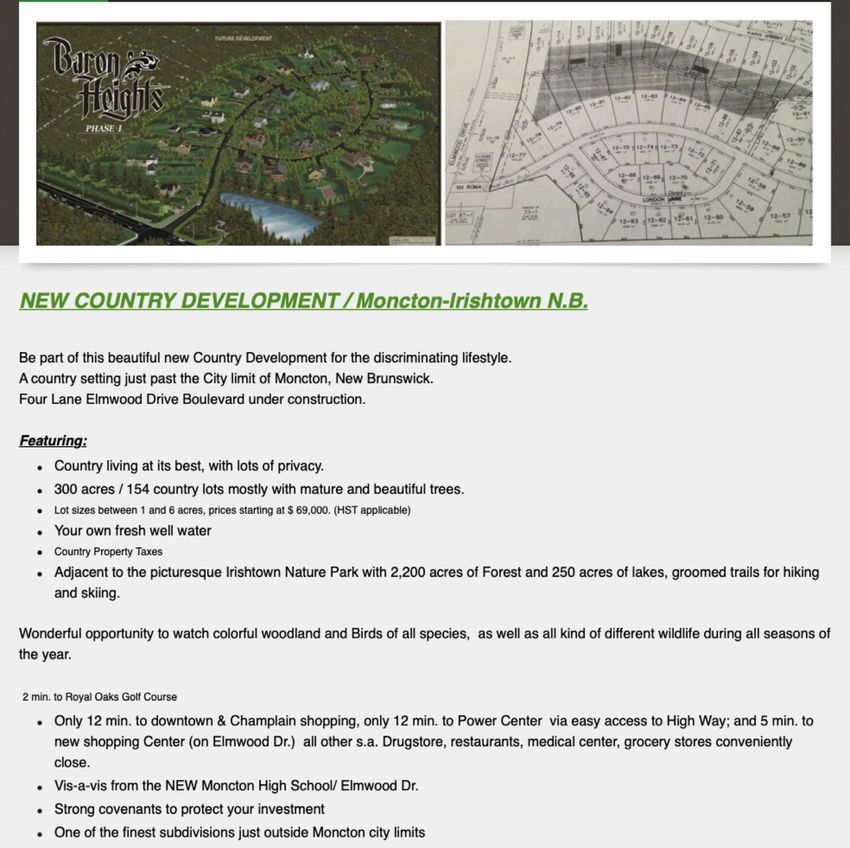
Population density is a key indicator of economic sustainability. A low population density
indicates a higher burden on taxpayers to pay for infrastructure and services, whether in an
urban or rural setting.

Figure 5 shows population density (number of people per square km) in greater Moncton,
where unincorporated areas and Rural Estates have significantly lower population density
than municipalities
.

           Figure 5. Population density per square km, shown by dissemination area (2016)

Rural estates have become widespread around the tri-communities:

•	Since 2006, more than 1,200 lots with a minimum size of one-acre have been approved
    around the tri-communities;
•	488 new single-detached dwellings were constructed in the Moncton and Coverdale LSDs
    between 2013 and 2018 (see Figure 6).

                                                 4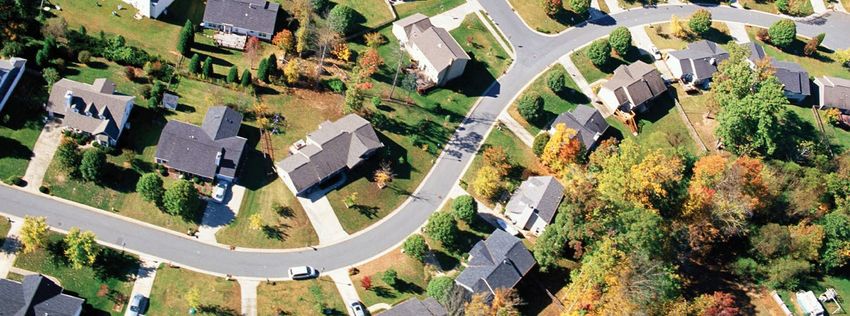
Several factors can be identified as contributing to the changes in observed settlement patterns
in the Moncton and Coverdale LSDs. These include:

•	The provincial subdivision regulation which establishes a minimum one-acre lot area where
    no water and sewer services are available;
  Preferential tax rates in the LSDs, averaging 45% less than in the tri-communities, which
•
    encourages high-end housing to be constructed outside of municipal limits;
•   Proximity to the tri-communities with short commute times.

The shift in settlement patterns, from traditional rural to Rural Estates in the Moncton and
Coverdale LSDs raises the following challenges:

  The financially unsustainable creation of new public roads, as we have demonstrated
•
    that property taxes generated in Rural Estates do not pay the lifecycle costs of the
    infrastructure required (see attached Lifecycle Cost Analysis Executive Summary);
•   Increased dependence on private vehicles;
•	Incompatibility of Rural Estates with traditional rural activities; as demonstrated
    in restrictive covenants in Rural Estates that prevent future subdivision and non-
    residential uses;
•   Loss of agricultural and environmentally sensitive land;
•	Rural estate subdivisions present further constraints on the future growth of municipalities.

The challenges raised by new settlement patterns in the Moncton and Coverdale LSDs can be
addressed by changes to subdivision standards in unincorporated areas. Through this planning
tool, development can be reoriented to optimize the use of existing infrastructure and reduce
the unsustainable creation of new public roads. Further, a managed approach to regional
development can help direct growth to maximise the use of existing infrastructure, while
protecting environmentally sensitive areas and promoting traditional rural uses. A change in
subdivision standards to discourage the construction of new public roads in unincorporated
areas is included in the proposed Westmorland-Albert Rural Plan. The proposed changes seek
to harmonise subdivision standards in unincorporated areas with those that currently exist
inside the boundaries of Moncton, Riverview, and Dieppe.

An analysis of available area for future subdivision and growth in Moncton and Coverdale LSD
found that there is currently enough supply of lots to sustain development over the next 15
years at the current construction rate (Figures 6 + 7). This is longer than the anticipated 10-year
lifespan of the Westmorland-Albert Rural Plan. This analysis also does not include future infill
lots that can be created along existing public roads.

                                                 5
NUMBER OF BUILDING PERMITS ISSUED FOR
                         THE CONSTRUCTION OF NEW DWELLINGS

                          28
                                         13                 22
                                                                             14
           17
                                                                                      24

          57              69            69                  66               63       46

         2013            2014           2015               2016             2017    2018

                                ¢ LSD Moncton            ¢ LSD Coverdale

    Figure 6. Building permits issued for new dwellings, Moncton and Coverdale LSDs, 2013-2018

                                        Scenario 1:                Scenario 2:     Scenario 3:
                                        Low growth               Average growth    High growth

Total building lots available                 1224                    1224             1224

Construction Rate (houses/year)                72                      81                  97

Remaining Years of Supply                     17.0                    15.1              12.6

         Figure 7. Summary of residential development projections based on available lots,
                                    Moncton and Coverdale LSDs

                                                     6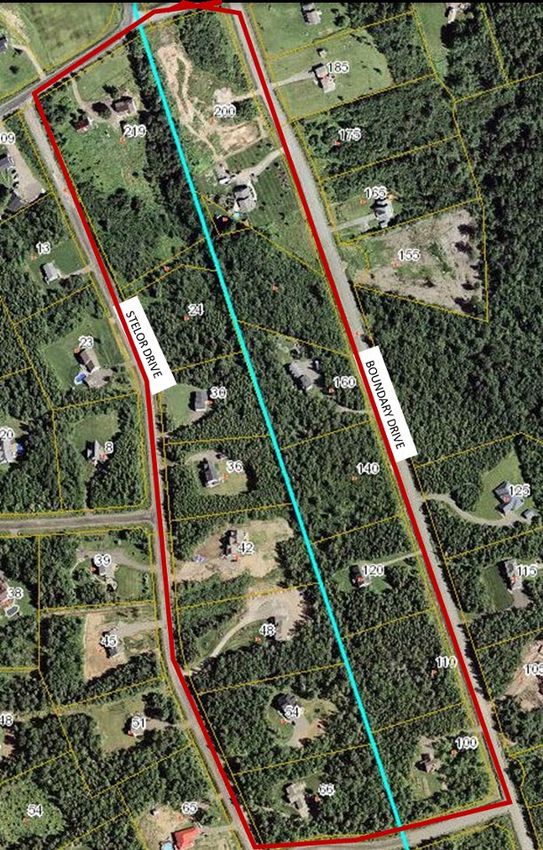
Table of Contents
Executive Summary                                                           1

Definitions                                                                 8

Part 1: Introduction                                                       10

Part 2: Examining recent settlement patterns in the Moncton CMA            12

Part 3: Factors influencing rural settlement patterns in the Moncton CMA   32

Part 4: Impacts of emerging development trends                             37

Part 5: Possible Solutions                                                 50

References                                                                 59

Appendix		                                                                 61

                                         7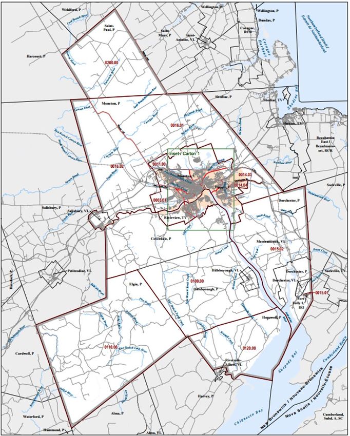
Definitions   Census Metropolitan Area (CMA): A CMA is formed by one or
              more adjacent municipalities centred on a population centre
              (known as the core). A CMA must have a total population of at
              least 100,000 of which 50,000 or more must live in the core. To be
              included in a CMA, adjacent municipalities must have at least 50%
              of their employed labour force that works in the core. The Moncton
              CMA is used in this report as it provides detailed statistics and vital
              information about the region.

              Census dissemination area: Census dissemination areas (DAs)
              are small areas composed of several neighbouring blocks, with
              a population of 400 to 700 persons. It is the smallest standard
              geographic area for which all census data are disseminated. All of
              Canada is divided into dissemination areas.

              Census tract: Census tracts (CTs) are small, relatively stable
              geographic areas that usually have a population between 2,500
              and 8,000 persons. A CMA is made up of various census tract,
              which provide more detailed statistics about that area.

                                  8
Census tract – urban: For the purposes of this report, urban census tracts were identified as
areas close to downtown Moncton and Dieppe. Urban census tracts have a predominant grid
street-pattern and a mix of different uses. The only census tracts that were defined as urban in
this report are 0001.00, 0002.00, 0006.00, 0007.00, 0009.00, and 0013.00. A map showing
the location of these tracts is in the appendix. This definition of urban only applies during the
analysis in Part 2 and Part 3.
Census tract - suburban: For the purposes of this report, suburban census tracts are located
within municipal boundaries but were not identified as an urban census tract.
Census tract – rural: For the purposes of this report, rural census tracts are in unincorporated
areas.
Legacy lots: Lots that have received development officer approval but have not been registered
i.e. are part of a planned future phase.
Local Service District (LSD): Local service districts are administrative units of unincorporated
areas for the purpose of assisting taxation and local service delivery.
Population density: Population density is a measurement of the number of people living per
unit of area.
Settlement pattern: refers to the physical characteristics of built-up areas shaped by the human
occupation of the territory. Settlement patterns describe the organization of space by the
transportation network; street blocks; land parcels; the layout, size and volume of buildings; the
density and compactness of development; and the distribution of activities and infrastructure.
Tri-communities: The tri-communities constitute the City of Moncton, the City of Dieppe and
the Town of Riverview. Together, the tri-communities form the urban core of the Moncton
Census Metropolitan Area (CMA).
Unincorporated area: Unincorporated areas are regions of land outside the limits of any
municipality or rural community. An unincorporated area is not governed by its own municipal
structure but rather is administered services by the Province or Regional Service Commission.
9PART 01 Introduction
The Greater Moncton region has lead growth in New Brunswick,
as the province’s fastest growing Census Metropolitan Area
(CMA) between 2011 and 2016. During this same period, much of
the province has seen its population decline. Over the past two
decades, the Moncton CMA has gained nearly 30,000 new residents.
Greater Moncton continues to be an attractive region to live and
work, with the City of Moncton, City of Dieppe and the Moncton
LSD featuring among the five fastest growing communities in New
Brunswick in 2016. This growth has brought new dynamism to the
region, but raises new challenges surrounding how to sustainably
support development.
Across Greater Moncton development pressures are confronting
a context of constrained financial resources for infrastructure,
the need to balance other economic activities in land use, and
of increasing attention towards protecting sensitive ecologic
areas. At the heart of this challenge, present day growth must not
compromise the future prosperity and quality of life in the region.
10An important share of this regional growth has occurred as un-serviced lots on the fringes
outside of municipal boundaries, in unincorporated areas. These rural settlement patterns
can be inefficient as the infrastructure costs related to these neighbourhoods may not be
recovered by the property taxes they generate.
This report focuses on emerging settlement
patterns in the Moncton CMA and examines
how changing development forms have
affected the region over the past 20
years. The major factors influencing shifts
in settlement patterns are discussed
along with its consequences. The report
concludes with proposed solutions for the
region, which will better optimize land and
infrastructure use in the unincorporated
areas of the Moncton CMA.
11PART 02 Examing recent settlement
patterns in the Moncton C.M.A.
Settlement patterns describes the geographic structure and
organization of human development. It is made up of the built
environment, which includes transportation networks, land
parcels, and buildings; the activities which take place there, in
addition to the natural topography. In other words, settlement
patterns describe where people live, work and do business in
relation to the land, water and important infrastructure such as
roads. Settlement patterns further includes intensity of land use,
the density of population and employment, and the compactness
or dispersion of buildings and infrastructure. Several different
settlement patterns exist within New Brunswick, differing by land
topography, the period of settlement and the intensity of uses.
Land development and population changes in the last twenty
years in the Moncton region, defined to be the Census Metropolitan
Area, point to global population trends in Greater Moncton and
more specific settlement patterns emerging in both municipalities
and local service districts.
12There are four main types of settlement patterns in the Moncton CMA:
Urban settlement are areas characterized by higher densities in population and
1.
infrastructure of the built environment. Urban settlement has a predominate grid street-
pattern and a mix of different uses. Buildings in urban settlement contrast with those in
other settlement patterns by their diversity in type, closer implantation and greater volume.
In the Greater Moncton area, urban settlement corresponds to a greater concentration of
employment and economic activity and forms the core of Downtown Moncton and the
inner neighbourhoods of the tri-communities.
Suburban settlement is characterized by lower densities in both population and
2.
infrastructure in contrast to urban settlement. Within suburbs, there is lower diversity of
different land uses and of building types. The street network in suburban communities
is typically curvilinear, with winding streets and occasional gaps in grid connections.
Suburban development areas in the Greater Moncton region are defined within municipal
areas and serviced by water and sewer. Suburban areas typically form the outer
neighbourhoods of the tri-communities including the North-end of Moncton and much
of Dieppe and Riverview. By extension, distances to employment and local services are
greater in suburban areas than in urban, necessitating the use of private cars.
Rural settlements are characterized by a low density of population. Rural settlements
3.
in Southeast New Brunswick, as elsewhere, possess economies based on agricultural
or resources activities. Land uses corresponding to these economic activities require
substantial area and contribute to a low population density. Road infrastructure, and in turn
communities, are often oriented in linear layouts along established regional connections.
Rural Estate settlements are areas outside of urban and suburban areas where significant
4.
residential activity has implanted. The built environment in Rural Estate settlements is
distinguishable from rural areas by the layout and density of the road network and lots.
Rural Estate settlements typically produce a near grid-like and cul-de-sac street pattern,
in contrast to linear rural settlement. Rural Estates also are based on lot sizes approaching
1 acre in area; these lots are not sufficient in size to support traditional rural activities
based on agriculture and resource extraction. Instead, such lots compete with urban and
suburban lots for residential development.
13Moncton CMA characteristics
According to Statistics Canada, a Census Metropolitan Area (CMA) is a statistical area that
has a total population of over 100,000, of which at least 50,000 live in a core. Outlying areas
are added to a CMA when 50% of the employed labour force commutes to the core of the
CMA. The Moncton CMA covers an area of approximately 2,559 square kilometers and had a
population of 144,810 in the 2016 census (Map 1). The CMA includes seven incorporated areas
(municipalities), eight unincorporated Local Service Districts (LSDs), and one First Nations
reserve (Fort Folly). The tri-communities of Moncton, Riverview, and Dieppe form the core
of the CMA. Using the CMA boundaries
provides a geographic area which shares
a common real estate market, labour
market, and degree of shared population
mobility. Major infrastructure projects
and economic forces hold the power to
shape and redirect development across
the entire CMA.
An analysis of the population changes
in this area over a 20-year period from
1996 to 2016 reveals the immense
growth the region has seen overall
in both incorporated (Table 1) and
unincorporated (Table 2) areas. During
this period, the population of the
entire Moncton CMA grew by 25%,
from 115,283 to 144,810 residents. Most
of the municipalities in the CMA saw a
population increase over the last 20
years and have an average density of
nearly 280 people living per square
kilometer. This far outpaces the CMA’s
total density, which is just 56.6 people
living per square kilometer.
The overall population trend from 1996 to
2006 is also shown graphically in Figure 8.
Map 1. Boundary of the Moncton CMA (Statistics Canada, 2017)
14Table 1. Incorporated areas and population change from 1996-2006, Moncton CMA (Statistics Canada, 2017)
Moncton CMA
Incorporated Population Population % growth Area (sqkm) Density
Areas 1996 2016 (per sq/km)
Moncton 59,313 71,889 21.20 141.92 506.50
Dieppe 12,497 25,384 103.12 54.05 469.60
Riverview 16,684 19,667 17.88 35.45 554.80
Memramcook 4,904 4,778 -2.57 187.67 25.50
Salisbury 1,882 2,284 21.36 13.54 168.70
Hillsborough 1,272 1,277 0.39 12.83 99.50
Dorchester 1,179 1,096 -7.04 5.79 189.30
Fort Folly* 33 40 21.21 0.55 72.50
Total 97,764 126,415 29.31 451.80 279.80
* Fort Folly is a registered First Nation Reserve that falls outside the provincial Local Governance Act and is therefore
not a partner in the Southeast Regional Service Commission.
Table 2. Unincorporated areas and population change from 1996-2006, Moncton CMA (Statistics Canada, 2017)
Moncton CMA
Unincorporated Population Population % growth Area (sqkm) Density
Areas 1996 2016 (per sq/km)
Moncton LSD 8,669 9,811 13.17 579.63 16.90
Coverdale LSD 3,948 4,466 13.12 236.04 18.90
Hillsborough LSD 1,532 1,308 -14.62 304.05 4.30
Elgin Parish LSD 1,027 892 -13.15 519.59 1.70
Elgin Centre LSD - 203 - 4.29 47.30
Hopewell LSD 812 647 -20.32 149.08 4.30
Dorchester LSD 555 429 -22.70 90.13 4.80
Saint Paul LSD* 980 842 -14.08 228.72 3.70
Total 17,523 18,598 6.13 2111.53 8.81
* Saint Paul LSD is in Kent County and is not a partner in the Southeast Regional Service Commission
15Figure 8. Population change in the Moncton CMA, 1996-2016
Growth in the municipalities of the Moncton CMA has not occurred evenly. In the City of Moncton
for instance, many of the downtown census tracts have been consistently losing population since
1996, whereas other areas of the region have seen enormous growth, such as the suburban
north end, Dieppe, and unincorporated areas on the fringe of the city. Figure 9 shows population
changes by census tracts in the CMA, focused on the tri-communities and the Moncton and
Coverdale LSDs. While the population of census tracts in the urban area of Moncton have
declined, those in suburban areas have exploded. A map showing census tract boundaries for
the entire Moncton CMA is available in the appendix.
Census data demonstrates a shift in settlement patterns has been occurring in the Moncton
CMA over the period of 1996 to 2016. Where growth has occurred in the region over the last
two decades, it has created a low-density community form concentrated on the periphery of
the tri-communities, requiring substantial linear amounts of infrastructure (particularly roads)
to service the development. While most population growth has been in outlaying areas within
municipalities, census data points to new growth just outside of municipal limits in the Moncton
and Coverdale LSDs, in the form of rural estate settlement.
16Figure 9. Population Change by Census Tract in the Moncton CMA.
Population Density
Population densities across the Moncton CMA are presented in Figure 10 by dissemination area.
The population densities of dissemination areas are globally higher within the municipal limits of
the tri-communities than in the local service districts. Population densities in the municipalities,
namely in urban settlement areas, makes public service and utility delivery more cost-effective,
as discussed later in Part 4. A greater concentration of people can additionally support more
local commerce, which generates not only employment opportunities but contributes to
neighbourhoods where goods and services are accessible by a variety of transit options such
as walking. Rural settlement, in contrast, is characterized by low population density, a pattern
observable in Figure 10 in the outlaying dissemination areas of the local service districts. In
rural settings, economic activities such as agriculture and forestry naturally require larger
areas of land. As discussed later in this section, the changes to the organization of land that
permit a large increase population density can hold a de-structuring effect on rural economies.
New population density in rural areas also raises the prospect of conflicts stemming from
17“nuisances” as a result of traditional and long implanted rural activities occurring in proximity
to new residential development.
Within the unincorporated area, a ring of higher density areas can be observed encircling the
municipal limits (shown in red). The dissemination areas bordering municipal limits have densities
inconsistent with neighbouring dissemination areas in the unincorporated areas that can be
thought of as rural settlements. Unincorporated areas are generally meant to accommodate
rural activities, such as agriculture and resource extraction. However, the reality is that many
subdivisions in the unincorporated areas function more as commuter neighbourhoods to the tri-
community, which can cause conflicts in situations where residents are inconvenienced by noise,
odours, or other nuisances caused by agricultural or other rural activities.
Figure 10. Population Density by Dissemination Area in the Moncton CMA
18Commuter flows
A look at commuter flows in and out of the Coverdale and Moncton LSDs proves that most residents
work in the tri-communities. Table 3 shows the place of work for residents in the Coverdale LSD.
Nearly 88% of residents commute to Moncton, Dieppe or Riverview, and a further 9% commute
to a different census subdivision, meaning only 2.72% of residents who live in the Coverdale
LSD work there. A similar relationship exists for the Moncton LSD (Table 4). More than 89% of
residents commute to the tri-communities daily, and a further 3.8% commute to a different census
subdivision, meaning that just less than 7% of the people that live in the Moncton LSD also work
there. Commuter flows demonstrate the role of new rural estate settlements in the two LSDs play
within the Moncton CMA as bedroom-commuter communities for the major employment poles
found in the municipalities of Moncton, Dieppe and Riverview. Such a function contrasts to more
traditional rural uses found in LSDs such as agriculture and resource development.
Table 3. Commuting flow from place of residence to place of work, Coverdale LSD (Statistics Canada, 2017)
Place of Residence Place of Work Total %
Moncton 1,085 65.56
Riverview 225 13.60
Dieppe 145 8.76
Coverdale LSD
Coverdale LSD 45 2.72
Other 155 9.37
Total 1,655
Table 4. Commuting flow from place of residence to place of work, Moncton LSD (Statistics Canada, 2017)
Place of Residence Place of Work Total %
Moncton 2,925 72.04
Dieppe 585 14.41
Moncton LSD 280 6.90
Moncton LSD
Riverview 115 2.83
Other 155 3.82
Total 4,060
19While a large majority of the active population in both the Moncton and Coverdale LSDs commute
to a different subdivision, this proportion is slightly more elevated in a ring surrounding the
municipal limits of the tri-communities. Figure 11 shows the proportions of commuters who travel
to a different census subdivision across the Moncton CMA. In areas such as Lutes Mountain,
Irishtown and Upper Coverdale, approximately 97% of working residents commute to work
outside of their local service district. New rural estate communities emerging in these areas
are, functionally, commuting neighbourhoods to the tri-community. This form of residential real
estate competes with projects in the municipal areas which have water and sewer services.
Serviced development, both urban and suburban, occurs at greater densities than rural estate
development and in turn consumes substantially less land. The form and location of the emerging
commuter communities in the LSDs has important implications on transportation mode choice.
Figure 11. Commuting flow from place of residence to place of work, by Dissemination Area.
Commute to a different
Municipality or LSD
Percent of Commuters (%)
0 - 10
10 - 20
20 - 30
30 - 40
40 - 50
50 - 60
60 - 70
70 - 80
80 - 90
90 - 100
N
Data Sources: Statistics Canada. (1997, 2017). Journey to
work for Dissemination Areas.
Statistics Canada. (2017). Boundary files.
20Transportation
The low-density nature of the Moncton CMA makes mobility by any means other than a private
automobile very difficult. As of 2016, over 89% of all commutes in the CMA are by car, either
as a driver or passenger (see Figure 12). Only about 3.4% of people take transit to work, and a
further 5.4% walk. This trend is more pronounced when looking at unincorporated areas, where
97% of commutes by residents in the Moncton and Coverdale LSDs are by car (as a driver or
passenger, Figure 14).
However, when looking at urban census
Transit Walk Bike Other tracts that have greater density, residents
4% 5% 1% 1%
are less dependent on their vehicles
(Figure 13). Although more than 70%
use vehicles, either as a passenger or a
driver to get to work, we see that nearly
20% of people walk, and 8% rely on
transit. Approximately 0.34% of people
in urban census tracts biked to work.
Urban settlement patterns, with a higher
density and mix of uses permits easy
Car accessibility to work by walking or transit.
89%
Distances between the place of residence
¡ Car ¡ Transit ¡ Walk ¡ Bike ¡ Other and place of employment are often
more suitable to walking in urban areas,
Figure 12: Journey to work, Moncton CMA, Statistics Canada (2017) where the settlement pattern assumes a
smaller footprint. The built form of urban
areas also plays an important role in improving the transportation mode choice. The presence of
sidewalks, crosswalks and pedestrian lights is one such example. Other factors include the density
of connections and paths offered by grid street-networks and the building façades and landscaping
lot fronts which contribute to a comfortable “streetscape” to walk on.
21Journey to work - Journey to work -
inner city Moncton and Coverdale LSDs
Bike Other Transit Walk Bike Other
0% 2% 1% 1% 0% 1%
Walk
19%
Transit
8%
Car Car
71% 97%
¡ Car ¡ Transit ¡ Walk ¡ Bike ¡ Other ¡ Car ¡ Transit ¡ Walk ¡ Bike ¡ Other
Figure 13: Journey to work, inner city Figure 14: Journey to work, Moncton
census tracts (2016) and Coverdale LSDs
Rural settlements, in contrast, have a limited offer of transportation choices owing to its low-
density character. Trips in rural areas often require great distances, leaving private cars as the
main viable transportation mode. Infrastructure for walking or cycling is often not present in some
rural areas at all. Rural Estate settlements inherit many transportation characteristics from rural
areas despite important distinctions. Rural Estate settlements are commuting communities, with
nearly all working residents travelling to the tri-communities for work or school. Rural Estates
themselves are located over 10 kilometres from the principal employment poles in the Moncton
CMA and are additionally outside the service of public transit. Trips to work, school or shopping
are thus only feasible by car. Roads in rural estate communities do not have sidewalks, and the
large lot size and ditching contribute to a scale that is uncomfortable for pedestrians. Commuter
residential areas within the tri-communities have a variety of transportation choice, including
public transportation service.
Car-dependency is expensive. It is estimated that New Brunswickers spend more of their income
on transportation than any other province. 18.9% of household income goes to transportation in
the province, which is significantly higher than the national average, where the average Canadian
household spends just 14.9% of its income on transportation (see Table 5) (Bourgeois et al.,
2014). This may be due to New Brunswick’s high dependence on vehicles and the high costs of
22vehicle ownership. The CAA has calculated that it costs approximately $10,457 a year to own a
car, all factors included (insurance, fuel, repairs, fees, etc.) (Bourgeois et al., 2014, p.2). On the
other hand, surveyed Canadians estimated the cost of owning a car at just $4,500, meaning that
people grossly underestimate the cost of their vehicles (Bourgeois et al., 2014, p.2). Taking public
transit or active transportation can save a household money, but it is generally not convenient or
practical in areas with low population densities. Public transportation is not an option for rural
areas outside of municipalities, where transit does not exist.
Table 5. Average spending by province, per household item, (Bourgeois et al., 2014, p.16)
Canada NL PE NS NB QC ON MA SK AB BC
Total expenditure 100.0% 100.0% 100.0% 100.0% 100.0% 100.0% 100.0% 100.0% 100.0% 100.0% 100.0%
Food expenditures 10.3% 10.9% 10.9% 10.6% 11.3% 11.9% 9.5% 10.7% 9.8% 8.7% 11.1%
Shelter 21.0% 17.5% 18.7% 20.0% 17.2% 19.4% 21.8% 19.2% 18.6% 19.9% 24.2%
Household operations 5.4% 6.1% 6.1% 6.0% 6.3% 5.3% 5.6% 5.0% 5.4% 5.3% 5.3%
Household furnishings & equipment 2.9% 3.3% 2.4% 2.7% 2.9% 2.9% 3.0% 2.9% 2.9% 3.0% 2.6%
Clothing & accessories 4.6% 5.3% 4.7% 4.3% 4.6% 4.8% 4.6% 4.6% 4.3% 4.7% 4.2%
Transportation 14.9% 17.6% 17.3% 15.9% 18.9% 14.6% 14.7% 15.9% 16.3% 15.1% 13.8%
Private transportation 13.4% 15.9% 16.3% 14.7% 18.0% 13.5% 13.1% 14.4% 15.1% 13.6% 11.8%
Public transportation 1.5% 1.7% 1.0% 1.2% 0.9% 1.2% 1.6% 1.5% 1.2% 1.5% 2.0%
Health care 3.0% 2.9% 3.5% 3.3% 3.6% 3.9% 2.4% 2.8% 2.8% 2.6% 3.9%
Personal care 1.6% 1.5% 1.4% 1.6% 1.7% 1.7% 1.6% 1.5% 1.6% 1.5% 1.5%
Recreation 5.0% 5.5% 6.0% 4.5% 5.3% 4.9% 4.5% 5.0% 5.2% 5.4% 6.1%
Education 1.8% 1.0% 1.2% 1.6% 1.3% 1.2% 2.4% 1.1% 1.3% 1.7% 2.0%
Reading materials & other printed matter 0.3% 0.2% 0.4% 0.3% 0.3% 0.3% 0.3% 0.3% 0.3% 0.3% 0.2%
Tobacco products & alcoholic beverages 1.7% 1.8% 1.5% 2.0% 1.7% 2.1% 1.4% 1.8% 1.8% 1.6% 1.9%
Games of chance 0.3% 0.3% 0.3% 0.4% 0.3% 0.2% 0.3% 0.3% 0.3% 0.3% 0.2%
Miscellaneous expenditures 1.9% 1.5% 1.4% 1.9% 1.7% 1.8% 2.0% 2.0% 2.2% 1.9% 1.8%
Income taxes 17.3% 16.5% 15.9% 16.2% 15.0% 17.3% 17.7% 17.8% 17.8% 20.1% 13.7%
23Subdivision
Substantial subdivision has occurred over the last decade within the Moncton and Coverdale
LSDs, concentrated principally within a few kilometres of municipal boundaries. There are several
large subdivisions (e.g. White Birch Estates, Irishview Estates, Domaine Nature, and Baron
Heights) that offer hundreds of large, 1+ acre lots within short commutes of the Moncton core.
These rural subdivisions, and others like them, surround the tri-communities in a circle, with
significant development in Lakeville, Irishtown, Indian Mountain, Berry Mills, Lower Coverdale, and
Melanson Settlement.
From 2006 to 2016, RSC records show that more than 1,100 lots (minimum size of 1 acre) have
been approved around the tri-communities (Table 6), representing thousands of acres of land
for potential development, much of which requires the construction of new public roads. Over
600 of those lots were approved in the Irishtown area alone. Large scale subdivisions with lot
sizes approaching the minimum size for un-serviced areas characterize this settlement pattern
in the unincorporated areas: functionally residential “estate” neighbourhoods without sewer
and water services.
Table 6. Number of new lots approved around the tri-communities, 2006 to 2016.
Location Number of Approved Lots
Irishtown 601
Berry Mills 11 1
Melanson Settlement 102
Lower Coverdale 100
Charles Lutes 54
Coverdale 52
Allison 52
Briggs Cross 29
Other 23
Total 1 124
24Legacy Lots
The subdivision of lots follows a two-step process: approval and registration. Approval is given
by a development officer when the plan meets all the necessary specifications for the creation
of streets and lots. The plan can then be registered with Service New Brunswick, which is when
the lots are created. However, larger subdivisions may have their plans registered in phases,
developing small sections at a time. Legacy lots are lots that have received approval, but have
not yet been registered, as they are part of a future phase. For example, the Baron Heights
subdivision in Irishtown went through an environmental impact assessment for a plan that shows
a total of 150 lots, but only about 25 lots have been registered to date. The other 125 lots that
have been approved are the legacy lots.
Figures 15 to 20 show the location of major subdivisions within proximity to the tri-communities,
including the years that lots were either registered or approved (in the case of legacy lots).
These Figures illustrate not only the substantial road infrastructure contained within rural estate
subdivisions, but also their distinction from the historic linear settlement pattern along rural
routes that was typical of development in the Southeast region.
25Figure 15. Overview of 5 subdivision ‘hotspots’ surrounding the tri-communities
Figure 16. Existing lots and number of legacy lots, Irishtown
26Figure 17. Existing lots and number of legacy lots, Lutes Mountain
Figure 18. Existing lots and number of legacy lots, Berry Mills
27Figure 19. Existing lots and number of legacy lots, Lower Coverdale
Figure 20. Existing lots and number of legacy lots, Melanson Settlement
28Another way to visualize growth in these areas is by the location of permits that have been
issued. Figure 21 shows the number of building permits for new residential units that were issued
by the Southeast Regional Service Commission from 2013 until August 2017, with a closeup on
the Moncton and Coverdale LSDs. It is possible to identify clusters that have seen lots of activity
over this period, including Irishtown, Berry Mills, Coverdale, Melanson Settlement, and Lakeville.
From 2013 to 2018, there were 370 building permits issued for new dwellings in the Moncton
LSD, and 118 building permits issued for new dwellings in the Coverdale LSD, which far outpaces
growth in any other area that the SERSC manages.
Figure 21. Location of permits released for new residential buildings, 2013 to August 2017
29Lot Size
The incremental subdivision of land to smaller lot sizes has a de-structuring effect on rural
activities. Decreasing lot size reduces the capacity for cultivation or raising livestock, effectively
limiting agricultural choices. Small lots are further uneconomical for woodlots and for resource
extraction which requires not only large areas to support activity, but substantial setbacks from
adjacent property. In effect, small lot sizes result in the loss of the rural character of the area, and
usually incite a change in the vocation of the land. Lots too small to support any agricultural or
resource activity compete with urban and suburban lots for residential development.
Median lot size varies geographically across the Moncton CMA (illustrated in Figure 22). Lot
size for dissemination areas in the unincorporated areas, close to municipal boundaries, hovers
around a median area between 1 and 2 acres. This size is too small to support agriculture or
resource activities and contrasts clearly with dissemination areas in the LSDs further from
municipal boundaries, where median lot sizes are several hectares (over 5 acres). Spatial trends
in parcel size indicate that subdivision of land is occurring prematurely, without water or sewer
services, in unincorporated areas adjacent to the tri-communities. Premature subdivision occurs at
excessively low-densities and requires substantial linear amounts of road infrastructure to service
it. Any future possibility of servicing development by water and sewer is typically uneconomical.
Figure 22. Median Lot Size by Dissemination Area in the Moncton CMA
30A new settlement pattern in the Local Service Districts
of Moncton and Coverdale
Analysis of population changes, recent subdivision and residential construction, aerial images
and commuter flows demonstrate a clear and widespread emergence of a settlement pattern
based on so-called Rural Estates in the Moncton and Coverdale LSDs. This community form
is characterized by a one-acre plus lot size, large enough to permit a well, septic system and
conform to provincial subdivision regulations, yet too small to permit non-residential (or
traditionally rural) uses. Median lot sizes observed in rural areas exceed several hectares, well
surpassing the observed sizes in areas such as Irishtown, Berry Mills, and Upper and Lower
Coverdale. Land parcels are oriented within a grid or cul-de-sac road structure, reproducing
a neighbourhood layout typical to the tri-communities of Moncton, Riverview and Dieppe but
at much lower densities. Despite the lower densities found within these subdivisions; they are
functionally bedroom commuter neighbourhoods within Greater Moncton as most employed
residents commute to the urban core of the tri-communities.
31PART 03 Factors influencing
rural settlement patterns
in Moncton CMA
Legislative framework
The observed residential settlement patterns in the Moncton and
Coverdale LSDs are enabled foremost by provincial legislation that
guides land use and development. The lot sizes in unincorporated
areas is dictated by the provincial subdivision regulation, which
dates from 1980. In an unincorporated area with no water and
sewer services available, the minimum lot size allowed is one-acre,
with a minimum road frontage of 54 metres. The size of the lot is
meant to allow enough room for a single-family dwelling as well as
a well and septic system.
However, the one-acre lot has become problematic in the Moncton
CMA, where residential demand for new lots has triggered
significant subdivision in the local service districts. The dimensions
32of the lots permit neither traditional rural activities such as agriculture or woodlots, nor does
it permit for a high population density, which poses financial challenges (in terms of capital
costs, maintenance, etc.) when new public roads are created solely for residential purposes.
Further, one-acre subdivisions on the outskirts of municipalities may compromise the future
growth of municipalities. As municipalities grow and reach their boundaries, annexing new
land is often a step that is taken to ensure long-term growth can be accommodated. However,
when the land at the outskirt of the municipality contains one-acre lot subdivisions, annexation
becomes less desirable because those subdivisions are not dense enough for the municipality
to provide services, such as water and sewer. The built-form of those subdivisions also makes
it difficult to accommodate new infill development in the future. Many of these subdivisions
attach restrictive covenants on the land that will limit future subdivision, new accessory
units or the introduction of new uses such as home industries. An overview and example of
restrictive covenants on rural estate communities are provided in the appendix.
Other legislative constraints limit the ability of the Regional Service Commission to respond
to changing development patterns in local service districts. For example, the RSC is not able
to implement development charges or to allow lots under one acre in size in development
nodes. The Regional Service Commission also has little guidance from the province on these
issues, which could be articulated through statements of provincial interest. A statement of
provincial interest is a regulation adopted by the province under the Community Planning Act
that provides municipalities and regional service commissions with guidance when creating
local plans. Although the province has had the legislative framework to create provincial
statements of interest since 1973, none have yet been adopted.
33Comparison to other jurisdictions
In fact, the underlying challenges posed by Rural Estate development is not unique to the
Moncton CMA. Across Canada, growing metropolitan regions have experienced premature
development – development occurring before the provisioning of water and sewer utilities
– in traditionally rural areas at the edges of city. The phenomenon of premature or leapfrog
development has been widely recognized as an important planning challenge for reasons not
unlike those in Moncton: escalating infrastructure costs, uncoordinated development, and
traffic.
In British Columbia and Québec, controls in the form of zoning taken at the provincial level
aim to control such a development and limit the loss or fragmentation of agricultural land.
In these provinces, subdivision of agricultural land is subject to the discretionary approval of
a commission mandated to protect agricultural land. Québec regional and municipal plans
further impose urbanization perimeters to direct growth into areas serviced by utilities.
Another response has been to adopt subdivision controls to limit residential development
in un-serviced areas. Outside of defined urban settlement areas, the Halifax Regional
Municipality limits possible subdivision and imposes high minimum lot sizes to discourage un-
serviced residential development. This has also been a key approach in Québec, where 75%
of subdivision by-laws have adopted greater minimum lot sizes outside of their urbanisation
boundaries (MAMH, 2019). In Québec, unincorporated areas are negligible in inhabited areas,
and are administered by the regional municipality. In many provinces, notably Manitoba and
Ontario, subdivisions are subject to the discretionary control of municipal councils. This is
also true for New Brunswick, where subdivision creating a new public street is subject to
approval of municipal council. In the unincorporated areas, subdivision creating new public
streets is approved “as-of-right”.
The Greater Moncton context is thus unique in terms of its development framework and
governance in Canada. The municipalities of the tri-communities have adopted policies to
limit un-serviced residential subdivision in their municipal plans and subdivision by-laws.
Approaches adopted by the tri-communities, namely increased minimum lot sizes and
policies to limit residential development outside of urban growth boundaries, reflect widely
adopted practice around North America. The absence of controls just outside municipal
limits, however, represents a hard limit on the effectiveness of such policies and continues to
permit subdivisions by right on the edges the largest city in the province.
34Tax Rates
Another factor encouraging new settlement patterns in the Moncton and Coverdale LSDs is
the property tax structure. In 2019, owner-occupied residential dwellings in the Moncton and
Coverdale LSDs were taxed at an average of $0.90 per $100 of assessed value, whereas the
municipalities of Moncton, Riverview and Dieppe had an average tax rate of $1.64 per $100
of assessed value. Residential properties just outside of municipal limits pay on average 45%
less in property taxes than neighbouring communities in incorporated areas.
Low property taxes in unincorporated areas
effectively act as a subsidy for development.
However, residents in unincorporated areas
depend on services that are provided by
municipalities. These services include,
recreational facilities, roads, and in some
instances, fire protection.
An example of the tax rate disparity in
the Moncton CMA is evident by examining
properties that have frontage on Stelor Drive in
the Moncton LSD, versus those properties that
have frontage on Boundary Drive in the City of
Moncton (See Figure 23). These properties are
in the same neighbourhood, are comparable in
size, and share a backyard, the property line of
which doubles as the city limits. The average
assessment value of homes in the Moncton
LSD on Stelor Drive is $408,825 with an
average tax levy of $4,000.73 paid to the local
service district. On boundary drive in the City
of Moncton, the average assessment value of
homes is slightly higher, at $414,350, whereas
the average levy paid is $5,996.35. Two of
the properties in this area have an assessed
value of around $500,000 for a single-family
dwelling. One is in the Moncton LSD and pays
approximately $4,750 of property tax whereas
Figure 23. Snapshot of Stelor Drive in the Moncton LSD (left of
the other property is in the city and pays
blue line) and Boundary Drive in the City of Moncton (right of blue
approximately $8,500 in property taxes. line). The improved properties in red are ones that were used to
determine the average property tax levy in this area.
35Location
The proximity to the tri-communities is another major factor influencing growth in the Moncton
and Coverdale LSDs. Irishtown is approximately 12 kilometers from downtown Moncton, a trip
that is easily made in under 20 minutes by car. In fact, all the major rural subdivisions – Baron
Heights, White Birch, and Domaine Nature – explicitly advertise the proximity to amenities
on their websites. See Appendix for examples of advertisements from the websites of three
developers in the study area, which place an important emphasis on the proximity to the tri-
communities, as well as low-property taxes, all while having access to nature in a rural setting.
Rural estate communities have emerged in unincorporated areas close to municipal boundaries
due to the geographic proximity and institutional differences between jurisdictions. Rural
estate development is intrinsically related to urban activities in Moncton in terms of providing
employment and services. The proximity of these areas makes them competitors with urban
and suburban residential development occurring within the municipalities. The municipalities
of Moncton-Dieppe-Riverview have already adopted tools to control this settlement pattern.
Locating just outside municipal boundaries benefits from an absence of controls and lower
taxes in the unincorporated areas coupled with the proximity of employment and services
in the tri-communities. Recent development in unincorporated areas close to municipal
boundaries are, in effect, exploiting a unique context which allows unchecked subdivision on
the outskirts of the largest urban centre in New Brunswick.
Community Services
Recent decisions taken have further incentivised the expansion of rural subdivisions,
particularly the placement of two new schools in the region. Moncton High School was
relocated from a downtown location to the northernmost edge of the city, close to Irishtown.
The Baron Heights subdivision advertises proximity to this school on their website for
prospective buyers (See appendix). In Dieppe, a new school to aid overcrowding is being built
on Dieppe Boulevard at the city’s southernmost boundary, adjacent to the rural Melanson
Settlement area and the Domaine Nature subdivision. It is unclear what costs are borne by
the cities that must bring additional services (water, sewer, expanded roads, sidewalks, etc.)
to these areas. The proximity of schools to rural estate subdivisions may play a role in further
stimulating development.
36PART 04 Impacts of
Emerging Development Trends
Sustainability of road infrastructure
The amount of infrastructure per capita already in place in the
Moncton CMA is significant. Figures 24-26 show the length of
paved public roads, unpaved public roads, and the total length of
public road infrastructure across the CMA. The City of Moncton has
approximately 10 metres of paved and unpaved public road per
resident (Figure 26), slightly above Dieppe and Riverview, which
both have approximately 8 metres of public road per capita. The
higher number of public roads per capita, the higher the burden on
taxpayers. The length of roads per capita also acts as an indicator
for the built-form of the region, as a higher number indicates
communities are more spread out, which in turn promotes the use
and reliance of cars as the primary form of transportation.
Evidently, the unincorporated areas of the CMA have a higher
number of roads per capita than municipalities. The Coverdale
LSD has about 33 metres of roads per capita whereas the Moncton
37LSD, with 38 metres of road per capita, has nearly four times the length of roads per capita
as the City of Moncton. However, these two LSDs have a substantially lower number of roads
per capita than other unincorporated LSDs in the Moncton CMA, including the Hillsborough
LSD (101 metres of road per capita), Hopewell (117 metres of road per capita), Dorchester (165
metres of road per capita), and Elgin (268 metres of road per capita. The entire CMA had
approximately 17.9 metres of road per capita in 2016.
Figure 24. Length of paved road infrastructure per capita, Moncton CMA, 2016
38Figure 25. Length of unpaved road infrastructure per capita, Moncton CMA, 2016
Figure 26. Length of total (paved and unpaved) road infrastructure per capita, Moncton CMA, 2016
39In the unincorporated areas of the Moncton CMA, New Brunswick’s Department of
Transportation and Infrastructure is responsible for the maintenance and operation of all
local roads. One-acre lot subdivisions require a greater length of road than developments
in municipalities, yet have fewer residents to finance their maintenance. In 2012, the Auditor
General of New Brunswick warned that new road construction could constrain the Province’s
ability to conduct rehabilitation and maintenance across the entire road network. As new
roads are added to the highway network, the limited funding available to the Province must be
spread over a greater distance. This can lead to road repairs being delayed, which ultimately
results in more expensive road work later. Long term maintenance of roads represents an
important cost on all New Brunswickers; in 2017 the Province spent an estimated $238.6
million on highway maintenance, including winter operations (summarized in Table 7).
Table 7. Road Maintenance and Operation Costs by Category, DTI (Millions of 2018 Dollars).
Expense Category 2017-18 2016-17 2015-16 2014-15 2013-14 2012-13 2011-12
Highway Maintenance - 29.7 27.3 27.7 24.8 27.7 29.2 34.8
Summer 1
Winter Maintenance 2 84.2 78.4 77.9 86.8 78.1 73.7 75.9
Capital Maintenance 2,3 124.8 102.3 - 53.3 55.5 55.9 57.9
Total 238.6 208.0 - 164.9 161.2 158.8 168.5
1. Source: Department of Finance, Province of New Brunswick. (2011-2018). Main Budget Estimates.
2. Source: Department of Transportation and Infrastructure. (2012-2018). Annual Reports.
3. Source: Office of the Auditor General. (2012). Report of the Auditor General, ch. 5 – Department of
Transportation and Infrastructure, Capital Maintenance of Highways.
40Lifecycle costs analysis
The Southeast Regional Service Commission has investigated the lifecycle costs of local
services and infrastructure within new residential subdivisions in the Moncton and Coverdale
LSDs in a 2019 study. Lifecycle cost analysis is a tool for evaluating the total cost of constructing,
operating, maintaining, and replacing an asset. LCCA applied to land use patterns allows the
evaluation of the financial impacts on the public of different forms of development.
This report demonstrates the life costs of these new subdivisions are not recuperated by their
corresponding property taxes. A sample of 7 rural estate communities were included in the
analysis, as shown on the map in Figure 27.
Figure 27. Location of development scenarios modelled for lifecycle cost analysis
All seven of these neighbourhoods are large, residential subdivisions in an unincorporated
area at the outskirts of the tri-communities. They fit the typology of a rural estate settlement
pattern, with large lot sizes and lots of linear infrastructure (roads) per capita. Some key
characteristics of these neighbourhoods are summarized in the table below:
41Table 8. Summary of Development Scenarios.
Scenario Lower Irishtown Birch Hill Forest Upper Berry Mills Melanson
Coverdale Brook Coverdale Settlement
Estates
Subdivision White Birch Saffron Birch Hill Forest Bunker Hill Stelor Domaine
Name Estates Brook Estates Nature, Daigle
Estates Development
Location Lower Irishtown Ammon Allison Upper Berry Mills Melanson
Coverdale Coverdale Settlement
Highway Niagara Route 115 Route 490 Route 106 Route 112 Melanson
Proximity Road Road
LSD Coverdale Moncton Moncton Moncton Coverdale Moncton Moncton
Total Lots 74 108 41 49 49 35 98
Gross Area 126.4 231.8 150.6 132.9 114.4 94.6 161.1
(acres)
Residential 105.6 202.1 140.3 119.7 102.6 81.4 127.2
Area (acres)
Total road 4155 5644 2164 2458 2193 2377 5624
length (m)
Road length 56.1 52.3 52.8 50.2 44.8 67.9 57.4
per household
(m/hh) a
Average $234,605 $321,553 $396,312 $327,062 $339,577 $442,335 $431,400
Property Value
(developed)
Average Tax 0.9198 0.9517 0.9367 0.9189 0.9215 0.9546 0.9505
Rate ($/$100)
Total Annual 159,680 $330,500 $152,200 $147,260 $153,050 $147,790 $401,840
Tax Levies
a. Road length per household refers to the total road length in the subdivision divided by the number of households. It is not
the average road frontage of lots in the subdivision, as both sides of a road are typically developed in these scenarios.
42The key findings of the lifecycle cost analysis were:
• Net lifecycle costs over a 50-year period ranged from a deficit of $3.2 million to a $270,000
surplus – amounting to a range of an annualized deficit of over $1,700 per household to
an annualized surplus of approximately $140 per household.
• Over an analysis period of 100-years, all scenarios were less financially viable; the total
lifecycle deficits were found to range from approximately $6.7 million to $1.6 million.
• Lifecycle costs over the 100-year period produce a range of annualized deficits from
$2,884 per household to $1,110 per household, with an average annual deficit of $1,615 per
household across all scenarios.
• All seven development scenarios modeled possess negative net present values over the
lifecycle of a 100-year analysis period.
• Public roads were the principal contributor to the lifecycle cost of rural subdivisions,
representing as much as 72% of total lifecycle costs.
• Development scenarios containing longer local road networks were less financially viable
over the analyzed lifecycle periods.
The development of rural estate communities has strong implications on the financial
sustainability of New Brunswick, and the long term competitivity of the Greater Moncton
area. The lifecycle costing demonstrates the important financial burden to the public tied to
the maintenance and replacement of new public roads in LSDs. The LCCA further highlights
the link between community planning and asset management. The type and location of
infrastructure present is largely dictated by community form and land use. Ultimately, an
informed approach integrating land use planning and asset management can better address
sustainability and resiliency issues in the region.
In this context, the delivery structure of road maintenance permits fiscal imbalances to occur,
stemming from a mismatch between those who pay for maintenance and those who use the
infrastructure. This problem is exacerbated by the discrepancy in tax rates between local
service districts and municipalities that was previously discussed in Part 3. This issue of
inequity has been already raised in several studies, as residents of municipalities who finance
their local roads through higher property taxes find themselves also paying for a portion of
local road maintenance in local service districts, where residents pay lower taxes (Finn, 2008).
A 2008 report from the Office of the Comptroller estimated this annual revenue shortfall
in local service districts as $55.4 million ($66.8 million in 2018), of which transportation
accounted for $38.2 million ($44.7 million in 2018) alone.
43You can also read