BUILDING DISASTER DAMAGE ASSESSMENT IN SATELLITE IMAGERY WITH MULTI-TEMPORAL FU- SION
←
→
Page content transcription
If your browser does not render page correctly, please read the page content below
Accepted for presentation at the ICLR 2020 AI For Earth Sciences Workshop

                                         B UILDING D ISASTER DAMAGE A SSESSMENT IN
                                         S ATELLITE I MAGERY WITH M ULTI -T EMPORAL F U -
                                         SION

                                          Ethan Weber                                           Hassan Kan
                                          Massachusetts Institue of Technology                  WL Research
                                          ejweber@mit.edu                                       hassanmohamed@alum.mit.edu
arXiv:2004.05525v1 [cs.CV] 12 Apr 2020

                                                                                      A BSTRACT

                                                    Automatic change detection and disaster damage assessment are currently pro-
                                                    cedures requiring a huge amount of labor and manual work by satellite imagery
                                                    analysts. In the occurrences of natural disasters, timely change detection can save
                                                    lives. In this work, we report findings on problem framing, data processing and
                                                    training procedures which are specifically helpful for the task of building damage
                                                    assessment using the newly released xBD dataset. Our insights lead to substantial
                                                    improvement over the xBD baseline models, and we score among top results on
                                                    the xView2 challenge leaderboard. We release our code used for the competition1 .

                                         1       I NTRODUCTION

                                         When a natural disaster occurs, quick and accurate information is critical to an effective response.
                                         To better deploy resources in affected areas, it is important for emergency responders to know the
                                         location and severity of the damages.
                                         Satellite imagery offers a powerful source of information and can be used to assess the extent and
                                         areas of damages. However, a common bottleneck in the current workflows involves the time it
                                         takes for human analysts to observe an affected area and identify damaged zones. This process can
                                         take hours in a situation where time is of the essence. It therefore presents room to be accelerated
                                         through leveraging artificial intelligence.
                                         In the last several years, Convolutional Neural Networks (Krizhevsky et al., 2012) have achieved
                                         human level performance on a variety of computer vision tasks, including object recognition and
                                         image segmentation (LeCun et al., 2015). These techniques are highly relevant and applicable in
                                         the case of satellite image analysis for disaster damage assessment (Ji et al. (2018); Cooner et al.
                                         (2016)).
                                         The main contributions of this work is a characterization of the importance of mono-temporal vs.
                                         multi-temporal settings when performing damage assessment with natural disaster along with in-
                                         sights on helpful image pre-processing techniques. The specific insights in this work are that sub-
                                         stantially better performance is obtained by independently feeding the pre and post-disaster images
                                         through a CNN with shared weights. The features are then fused before a semantic segmentation
                                         final layer. Furthermore, working on smaller image crops and weighting error on damage classes
                                         inversely proportional to their statistical occurrence in the training dataset leads to models strongly
                                         improving over baseline models.

                                         2       R ELATED W ORK

                                         In this section, we highlight related work in computer vision and large-scale datasets for disaster
                                         damage analysis. In particular, we focus on building disaster damage assessment.

                                             1
                                                 https://github.com/ethanweber/xview2

                                                                                            1
Accepted for presentation at the ICLR 2020 AI For Earth Sciences Workshop
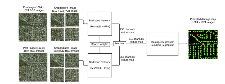
Figure 1: Our model architecture. For building damage assessment, we feed pre and post-disaster
images through a ResNet50 backbone with shared weights. We then concatenate features before
semantic segmentation to obtain our final building damage predictions. The output is a 5-class
damage map ranging from no building (0) to destroyed building (4).
2.1 C OMPUTER V ISION T ECHNIQUES FOR B UILDING DAMAGE A SSESSMENT
Researchers have applied machine learning approaches to building damage assessment in satellite
imagery. Xu et al. (2019) described a method to build convolutional neural networks that automat-
ically detect damaged buildings in satellite images using pre and post images and showed that the
model can generalize well to new regions and disasters if it is fine-tuned on a small set of examples
from that region. Their work is done on a proprietary dataset spanning three disasters and is framed
as a binary pixel classification over damaged/not damaged buildings.
Cooner et al. (2016) compared the performance of multiple machine learning methods in building
damage detection with both pre and post-event satellite imagery of the 2010 Haiti earthquake, and
found that a feed-forward neural network achieved the lowest error rate of 40%. Ji et al. (2018)
developed a convolutional network to identify collapsed buildings from post-event satellite imagery
of the Haiti earthquake, and reached an overall accuracy of 78.6%. Duarte et al. (2018) combine
drone and satellite images of disasters to improve the accuracy of their convolutional networks, with
a best reported accuracy of 94.4%. In these settings damaged building detection over images is
framed as a binary pixel classification problem.
Yang et al. (2018) show that convolutional neural network (CNN) can perform feature-based multi-
temporal remote sensing image registration and can outperform four state-of-the-art methods in
most scenarios. Nia & Mori (2017) show that convolutional neural networks can perform damage
assessment on post disaster image. However, their dataset uses ground-level images instead of
satellite images.
2.2 DATASETS FOR DAMAGE ASSESSMENT
Until xBD (Gupta et al., 2019), adequate satellite imagery addressing building damage was not
generally available. Other satellite imagery datasets were often limited to single disaster types and
did not have common criteria for assessing damage assessment (Fujita et al. (2017); Chen et al.
(2018); Foulser-Piggott et al. (2012)). This made comparing model and agreeing on a problem
framing difficult.
The xview dataset (Lam et al., 2018) is a precursor to the xBD dataset. It is one of the largest
and most diverse publicly available object detection datasets, with over 1 million objects across 60
classes in over 1,400 km2 of imagery. It focuses on object detection and not on building damage
assessment.
The complete xBD dataset contains satellite images from 19 different natural disasters across 22,068
images and contains 850,736 building polygons. Each image has a 1024 by 1024 pixels resolution.
2Accepted for presentation at the ICLR 2020 AI For Earth Sciences Workshop
Images are collected from WorldView-3 satellites at 0.3m spatial resolution. The imagery covers a
total of 45,361.79 km2 . It also introduces a four-level damage annotation scale.
3 M ODEL
In this section, we explain the task of building damage assessment and data pre-processing. Given
the nature of the xBD dataset, with pre-disaster and post-disaster images, we exploit the multi-
temporal information to predict both building locations and damage level with the same network.
For localization the task is to predict 0 or 1 (background or building) and for damage assessment the
task is to predict a 5 dimensional output: 0 is no building and 1-4 is the damage level (1: undamaged,
2: minor, 3: major: 4: destroyed). An alternative approach, which we found to be the best, is focus
on only damage assessment but say damage levels 1-4 are “buildings”. This avoids the problem of
using completely separate networks, as done in the xBD baselines (Gupta et al., 2019). We find this
very important to our final results.
Architectures Two-image input (pre and post) 512 x 512 images Joint prediction Class-specific weighting Overall F1 Localization F1 Damage F1
Instance seg. 0.492 0.705 0.401
Semantic seg. 0.536 0.819 0.414
Semantic seg. X 0.835
Semantic seg. X X X 0.729 0.847 0.679
Semantic seg. X X X X 0.738 0.835 0.697
Table 1: Our ablation study. In this table, we show the experiments that inform our final model.
The best model uses semantic segmentation, both pre and post image as input, 512 x 512 image
crops, joint building localization and damage prediction, and cross-entropy loss weightings to handle
class-imbalance.
3.1 BASELINE A RCHITECTURE
The first decision in this work is related to problem framing. For this work, we are focused on
building damage assessment, which means we care about both (i) building localization and (ii)
building per-pixel damage classification. Because we have two tasks (i.e. identifying the building
and determining the damage level), we decided to use the same model architecture for both tasks.
However, the baseline model uses two separate networks.
The task and baseline models are described in the xBD paper (Gupta et al., 2019). For localization, a
U-Net (Ronneberger et al., 2015) architecture is used for binary pixel classification of “background”
or “building”. For damage assessment, the model is less straightforward. It uses post-damage
images fed into a ResNet-50 backbone (He et al., 2016) pre-trained on ImageNet (Deng et al., 2009)
and additional features from a shallow CNN. All convolutional layers use a ReLU activation. The
output is a one-hot encoded vector where each element represents the probability of an ordinal class.
The model uses an ordinal cross-entropy loss function. Unlike traditional cross-entropy, ordinal
cross-entropy penalizes relative to the distance between true and predicted ordinal class. Since the
difference between any two classes is not interchangeable, this loss function allows the model to
distinguish between the different levels of damage.
Extending beyond this baseline, we decided that using the same network for both building detec-
tion and damage assessment was a more natural formulation of the problem. This way the model
can jointly reason about similar features. For this reason, we use a Mask R-CNN backbone (He
et al., 2017) augmented with a Feature Pyramid Network module (Lin et al., 2017) and a semantic
segmentation head. The model was pretrained on the ImageNet dataset (Deng et al., 2009). The
implementation of this Mask R-CNN architecture was obtained using the Detectron2 (Wu et al.,
2019) library from Facebook AI Research which has PyTorch (Paszke et al., 2019) implementations
of other models as well. With this backbone, we tried both instance segmentation and semantic
segmentation to generate the per-pixel classification output. Our final model uses semantic segmen-
tation, as it’s a more natural damage-assessment formulation without the notion of instances. Often
time, the buildings are too small for instance segmentation to be appropriate.
For the loss function, we use cross-entropy loss on the predicted classes with the ground truth labels.
3Accepted for presentation at the ICLR 2020 AI For Earth Sciences Workshop
3.2 DATA P ROCESSING T ECHNIQUE
With the xBD dataset, we have both pre-disaster and post-disaster images available, which can be
used for the two tasks of building localization and damage assessment. The images are 1024 by
1024, but we found that the buildings were often too small resolution for the model to accurately
draw building boundaries. For this reason, we trained and ran models on 4 512 by 512 images
forming the top-left, top-right, bottom-left and bottom-right quadrants.
Furthermore, given this pre and post data, damage assessment can be framed as either a mono-
temporal and multi-temporal task (Xu et al., 2019). In the mono-temporal setting, only the post
images are fed to a model that has to predict damage level per pixel. In the multi-temporal setting,
both the pre and post images are fed to the model that has to predict damage levels on the post
images. In this case we fed both the pre and post images independently through the R-CNN base,
with shared weights. These features were then concatenated before being fed through the semantic
segmentation head of the networks. We show our best architecture in Figure 1.
F-1 score (overall) No Damage F1 Minor Damage F1 Major Dmg F1 Destroyed F1
xBD Baseline 0.265 0.663 0.144 0.009 0.466
Our model 0.741 0.906 0.493 0.722 0.837
Table 2: Comparison with xBD baseline. On all metrics, our best model outperforms the xBD
baseline model by a large margin.
4 E XPERIMENTS
In this section, we explain the dataset and experiments used to inform the final model design. The
metrics used are for building localization and damage assessment from the xView2 competition2
((Gupta et al., 2019)).
4.1 X BD DATASET
This work is one of the first to apply recent deep learning techniques to the xBD dataset. xBD
is the largest and first building damage assessment dataset released to date. It contains 1024 x
1024 satellite imagery with 30cm per pixel resolution covering a diverse set of disasters–including
earthquakes, floods, volcanic eruption, wildfire and wind–and geographical locations (16) with over
850,000 building annotations (on a 1 to 4 damage scale) across over 45,000 km2 of imagery before
and after disasters.
4.2 A BLATION S TUDY
For the task of multi-class pixel classification, both instance segmentation and semantic segmenta-
tion are common solutions. The goal of instance segmentation is assign a class and instance ID to
every pixel. Similarly, the goal of semantic segmentation is to assign a class to every pixel, but in
this case the notion of instance ID is not used. The nature of damage assessment is more suited for
semantic segmentation, where instances IDs are not relevant.
Given the success of instance segmentation networks such as Mask R-CNN (He et al., 2017), we
perform experiments with both instance segmentation and semantic segmentation architectures. Fur-
thermore, we experiment with using image crops, both pre and post images as the input, predicting
localization and damage together, and weighting the class loss inversely proportional to the training
set distribution.
Looking at Table 1, we see the different experiments used to choose our best model. Notice that the
F1 score is computed with the xBD test set withheld for the xView2 competition. Localization F1
score is for building detection (0-1) and damage F1 is for damage assessment (0-4). When using a
joint prediction, we classify all pixels with damage level at least 1, to be a building. This is how we
use the same network for both tasks. Overall F1 is a weighted combination of 30% localization F1
and 70% damage F1.
2
https://xview2.org/
4Accepted for presentation at the ICLR 2020 AI For Earth Sciences Workshop
In the first row (row 1), instance segmentation is used on full 1024 x 1024 images. In the case
of overlapping bounding boxes, we use the label with higher damage prediction. By switching to
semantic segmentation (row 2), we notice a large improvement in localization (0.114). This is due to
the building box predictions suffering on small building sizes. By using 4 512 x 512 crops per image
(row 3), we obtain a boost in localization F1 of 0.016. By using our multi-temporal input with pre
and post images and adding the joint prediction (row 4), we see an increase for all metrics. Lastly
(row 5), we add class-specific cross-entropy weighting to obtain an increase in damage and overall
F1, while only losing slight performance in localization F1. This is because we put more weighting
on building damage classification. The reason for this weighting is that the 73.6% of polygons have
no damage. Furthermore, most of the image is the “no building” class.
We don’t show this in the table, but simple concatenation of pre and post images to produce a 6-
channel input produced very poor results. Similarly, subtracting the pre and post images before input
did not work well either. Our best results were obtained when processing pre and post images indi-
vidually, and then concatenating the features before segmentation. Instead of a single-network 256
channel feature embedding being used with the semantic segmentation head, we use 512 features
from stacking the pre and post image features coming from the FPN before the semantic segmenta-
tion head, which predicts the final 5 classes.
4.3 T RAINING
We performed most experiments on a machine with 4 NVIDIA 1080 TIs, and training takes roughly
6 hours to convergence when using ImageNet pretrained weights. When training for too long, the
network will collapse into predicting all 0 (no building) labels. Our inversely proportional class
weightings allows the network to train longer before collapsing, but it doesn’t solve the issue entirely.
Code will be released for replication of our work.
5 R ESULTS
With our final model, we obtain a localization F1 of 0.835 and damage F1 of 0.697. These metrics
are combined to obtain an overall F1 of 0.738 in the xView2 competition with the xBD test set.
In Table 2, we show the breakdown of the building damage assessment result compared to the
xBD baseline. The metrics are computed on the holdout set, and we outperform baselines by a
large margin. Notice that this is compared to the xBD baseline, but our results are competitive
on the xView2 leaderboard, in which we were ranked place 2 in Track 3: ”Evaluation Only”, and
40th place before non-validated submissions were removed. Our code is available at https://
github.com/ethanweber/xview2.
6 C ONCLUSION
In conclusion, the four main insights behind our performance include working with image quadrants
instead of the full image, using one architecture trained on both the pre and post images and fused
before the final segmentation layer, using the Mask R-CNN with FPN architecture and engineering
our loss function to weight errors on classes inversely proportional to their occurrence on the dataset.
Future research directions include using an ordinal cross-entropy loss function to penalize errors in
the damage scales differently and also experimenting with other ways to combine the information
from the pre and post images at different stages of feature extraction. Incorporating the disaster type
(e.g. flood, fire, etc.) into the building damage assessment prediction could also be an interesting
direction.
R EFERENCES
Sean Andrew Chen, Andrew Escay, Christopher Haberland, Tessa Schneider, Valentina Staneva,
and Youngjun Choe. Benchmark dataset for automatic damaged building detection from post-
hurricane remotely sensed imagery. arXiv preprint arXiv:1812.05581, 2018.
5Accepted for presentation at the ICLR 2020 AI For Earth Sciences Workshop
Austin J Cooner, Yang Shao, and James B Campbell. Detection of urban damage using remote
sensing and machine learning algorithms: Revisiting the 2010 haiti earthquake. Remote Sensing,
8(10):868, 2016.
Jia Deng, Wei Dong, Richard Socher, Li-Jia Li, Kai Li, and Li Fei-Fei. Imagenet: A large-scale hi-
erarchical image database. In 2009 IEEE conference on computer vision and pattern recognition,
pp. 248–255. Ieee, 2009.
D Duarte, Francesco Nex, N Kerle, and George Vosselman. Satellite image classification of building
damages using airborne and satellite image samples in a deep learning approach. ISPRS Annals
of Photogrammetry, Remote Sensing & Spatial Information Sciences, 4(2), 2018.
R Foulser-Piggott, R Spence, K Saito, DM Brown, and R Eguchi. The use of remote sensing for post-
earthquake damage assessment: lessons from recent events, and future prospects. In Proceedings
of the Fifthteenth World Conference on Earthquake Engineering, pp. 10, 2012.
Aito Fujita, Ken Sakurada, Tomoyuki Imaizumi, Riho Ito, Shuhei Hikosaka, and Ryosuke Naka-
mura. Damage detection from aerial images via convolutional neural networks. In 2017 Fifteenth
IAPR International Conference on Machine Vision Applications (MVA), pp. 5–8. IEEE, 2017.
Ritwik Gupta, Richard Hosfelt, Sandra Sajeev, Nirav Patel, Bryce Goodman, Jigar Doshi, Eric Heim,
Howie Choset, and Matthew Gaston. xbd: A dataset for assessing building damage from satellite
imagery. arXiv preprint arXiv:1911.09296, 2019.
Kaiming He, Xiangyu Zhang, Shaoqing Ren, and Jian Sun. Deep residual learning for image recog-
nition. In Proceedings of the IEEE conference on computer vision and pattern recognition, pp.
770–778, 2016.
Kaiming He, Georgia Gkioxari, Piotr Dollár, and Ross Girshick. Mask r-cnn. In Proceedings of the
IEEE international conference on computer vision, pp. 2961–2969, 2017.
Min Ji, Lanfa Liu, and Manfred Buchroithner. Identifying collapsed buildings using post-earthquake
satellite imagery and convolutional neural networks: A case study of the 2010 haiti earthquake.
Remote Sensing, 10(11):1689, 2018.
Alex Krizhevsky, Ilya Sutskever, and Geoffrey E Hinton. Imagenet classification with deep convo-
lutional neural networks. In Advances in neural information processing systems, pp. 1097–1105,
2012.
Darius Lam, Richard Kuzma, Kevin McGee, Samuel Dooley, Michael Laielli, Matthew Klaric,
Yaroslav Bulatov, and Brendan McCord. xview: Objects in context in overhead imagery. arXiv
preprint arXiv:1802.07856, 2018.
Yann LeCun, Yoshua Bengio, and Geoffrey Hinton. Deep learning. nature, 521(7553):436–444,
2015.
Tsung-Yi Lin, Piotr Dollár, Ross Girshick, Kaiming He, Bharath Hariharan, and Serge Belongie.
Feature pyramid networks for object detection. In Proceedings of the IEEE conference on com-
puter vision and pattern recognition, pp. 2117–2125, 2017.
Karoon Rashedi Nia and Greg Mori. Building damage assessment using deep learning and ground-
level image data. In 2017 14th Conference on Computer and Robot Vision (CRV), pp. 95–102.
IEEE, 2017.
Adam Paszke, Sam Gross, Francisco Massa, Adam Lerer, James Bradbury, Gregory Chanan, Trevor
Killeen, Zeming Lin, Natalia Gimelshein, Luca Antiga, et al. Pytorch: An imperative style, high-
performance deep learning library. In Advances in Neural Information Processing Systems, pp.
8024–8035, 2019.
Olaf Ronneberger, Philipp Fischer, and Thomas Brox. U-net: Convolutional networks for biomed-
ical image segmentation. CoRR, abs/1505.04597, 2015. URL http://arxiv.org/abs/
1505.04597.
6Accepted for presentation at the ICLR 2020 AI For Earth Sciences Workshop
Yuxin Wu, Alexander Kirillov, Francisco Massa, Wan-Yen Lo, and Ross Girshick. Detectron2.
https://github.com/facebookresearch/detectron2, 2019.
Joseph Z Xu, Wenhan Lu, Zebo Li, Pranav Khaitan, and Valeriya Zaytseva. Building damage detec-
tion in satellite imagery using convolutional neural networks. arXiv preprint arXiv:1910.06444,
2019.
Zhuoqian Yang, Tingting Dan, and Yang Yang. Multi-temporal remote sensing image registration
using deep convolutional features. IEEE Access, 6:38544–38555, 2018.
7You can also read