Registration of untypical 3D objects in Polish cadastre - do we need 3D cadastre?
←
→
Page content transcription
If your browser does not render page correctly, please read the page content below
GEODESY AND CARTOGRAPHY                                                                              c Polish Academy of Sciences
Vol. 61, No 2, 2012, pp. 75-89                                                                  DOI No 10.2478/v10277-012-0023-8

Registration of untypical 3D objects in Polish cadastre – do we need
                            3D cadastre?
                                                     Karabin Marcin
                                Warsaw University of Technology, Faculty of Geodesy and Cartography
                       Department of Cadastre and Land Management, Plac Politechniki 1, 00-661 Warsaw, Poland
                                                    e-mail: M.Karabin@interia.pl

Received: 12 July 2012/Accepted: 26 October 2012

         Abstract: Polish cadastral system consists of two registers: cadastre and land register. The
         cadastre register data on cadastral objects (land, buildings and premises) in particular lo-
         cation (in a two-dimensional coordinate system) and their attributes as well as data about
         the owners. The land register contains data concerned ownerships and other rights to the
         property. Registration of a land parcel without spatial objects located on the surface is not
         problematic. Registration of buildings and premises in typical cases is not a problem either.
         The situation becomes more complicated in cases of multiple use of space above the parcel
         and with more complex construction of the buildings.
               The paper presents rules concerning the registration of various untypical 3D objects
         located within the city of Warsaw. The analysis of the data concerning those objects regi-
         stered in the cadastre and land register is presented in the paper. And this is the next part of
         the author’s detailed research. The aim of this paper is to answer the question if we really
         need 3D cadastre in Poland.

Keywords: 3D cadastre, base map, cadastral system

1. Introduction

The basic legal act concerning geodesy and cartography in Poland – The Act of May 17,
1989 The Geodetic and Cartographic Law (Polish Parliament, 2010), defines the cada-
stre in Poland in the following way ”the uniform at the national scale, and systematically
updated set of information on lands, buildings and premises, their owners and other
individuals or entities, who possess those lands, buildings and premises”.
     In its further part, the Act defines the details and specifies the scope of data. It
states, that: the cadastre includes information on:
1) lands – their location, boundaries, area, land use types, soil classes, designation in
    land register or files of documents, if they exist for given real estates, including the
    discussed lands,
2) buildings – their location, intended use, useful functions, general technical specifi-
    cations,
3) premises – their location, functions and size.
76                                      Karabin Marcin

Considering the above, three types of cadastral objects (land parcels, buildings and
premises), as well as cadastral subjects (owners and/or possessors) are distinguished
in the cadastre.
     The scope of data registered in the cadastre is specified in details by the Instruction
to the Legal Act, i.e. the Decree of the Minister of Regional Development and Housing
of March 29, 2001 (Minister of Regional Development and Housing, 2001).
     Definition of a land parcel and limitation of the extent of the property rights to
real estates were described by the author in details in Karabin (2011b). Definition and
registered data concerning buildings are specified in §63 of the Cadastral Law and
were described by the author in details in Karabin (2011b).
     Issues concerning registration of premises in the cadastre have been discussed
by the author in the paper ”Registration of the Premises in 2D Cadastral System in
Poland”, which was presented during the FIG Working Week 2011 in Marrakech,
Morocco (Karabin, 2011a).
     In this paper there are shown the rules concerned with the registration of various
untypical 3D objects located within the city of Warsaw, the capital of Poland. There
are presented the results of analysis of the data concerning those objects registered
in Cadastre and Land Register. Registration of underground objects is not the subject
of cadastral registration in Poland, but the spatial information about those objects is
included in base maps.
     This is the next part of the author’s detailed research in this field. The first results
were published in the paper “Rules concerned registration of the spatial objects in
Poland in the context of 3D cadaster’s requirements” presented during 2nd International
Workshop on 3D Cadastres Delft in, Netherlands on 16-18 November 2011. The aim
of the current paper is to answer the question if we really need 3D cadastre in Poland.
     In many countries various activities concerned with 3D cadastres have been con-
ducted. The start of the researches related this issue we can assume by the 1st Workshop
on 3D cadastres held in Delft in November 2001. Workshop held in Delft in the year
2011 allowed for detailed analysis of present conditions and directions of development
of cadastral solutions, existing in the world, related to registration of 3D objects. Initial
researches concerned with 3D cadastres are conducted in Latin countries (Erba and
Graciani, 2011), Croatia (Vucic et al., 2011), Nepal (Acharya, 2011), Hungary (Ivan,
2011). Aspect of height system for 3D cadastres was detailed analysed by Austrian
research’s workers (Navratil and Unger, 2011). Tsiliakou and Dimopoulou (2011) have
compared situation in the Netherlands, Australia, Israel and Greece. 3D topology in
cadastral systems is a very significant direction of researches in China (Ying et al.,
2011), Australia and Netherlands (Thompson and Oosterom, 2011). Data modelling in
3D cadastres is an important topic of researches in Australia and Netherlands (Aien et
al., 2011). Very complex and advanced technical solutions (prototypes) are drawn up
by Asian and Dutch experts (Guo et al., 2011).
     There does not exist a single best solution for a 3D cadastre. Further researches
on technical, organizational and legal aspects of 3D cadastres are necessary, also in
Poland.
Registration of untypical 3D objects in Polish cadastre...         77

2. Analysis of registration of untypical 3D objects in the cadastre

In this section the author presents results of tests concerning selected, untypical spatial
objects in the cadastre. In the majority of cases the term “untypical” refers to typical
cadastral objects, i.e. buildings, which – due to their complex constructions – become
“untypical” cadastral objects in the process of their registration in the conventional
cadastre. At present, modern architecture has permanently entered the urban landscape,
and the cadastre, unfortunately, remains in its traditional approach – as the system which
registered the spatial objects, but in the 2D approach. In this section such objects, which
– by definition – are not cadastral objects, but in other countries their presence in the
cadastre is considered. These are underground tunnels, metro and other objects of the
underground infrastructure.
     For each case analysis of cadastral registration of real estates, in the descriptive
part has been performed (also for the buildings register), on the cadastral map in land
register. Records on the base map were also analysed and investigated objects were
photographically documented.
     This is the next part of the author’s detailed research. The first results were publi-
shed in the paper “Rules concerned registration of the spatial objects in Poland in the
context of 3D cadastre’s requirements” (Karabin, 2011b).

            2.1. Underground garage crossing parcels and above ground
                           connector – test object No 1

The first test object is the building of one of state institutions located in the centre of
Warsaw, in Krasiński Square. It is presented in the figure 1. This building is partially
located over the street, which consists of two cadastral parcels No 19 and No 49/1.
Generally the building is located on land parcels: No 66, No 49/1, No 48/1 and No
1/2 from the cadastral block 5-02-08 and on land parcels: No 19 and No 3/3 from
the cadastral block 5-02-07. Additionally, the underground two level parking area is
located on the cadastral parcel No 3/4. It is used by employees of institutions which
have their offices at the above building, as well as by inhabitants and tourists, since the
discussed building is located close to the monumental, old part of Warsaw. Therefore
the parking area is accessible for all. What is important, exits from the parking area
onto the terrain surface are located in the parts of the building under the above-ground
connector, i.e. on parcels No 19 and No 49/1 (the parking area is connected under the
ground with the discussed building and situated under the street).
     Some initial investigations concerning that object were performed as early as in
2008 (investigation concerned only the over ground connector). Those investigations
were supervised by the author and they were performed by Katarzyna Góźdź within the
frames of the master’s thesis „Analysis of foreign solutions in the field of registration
of three-dimensional (3D) objects in the cadastre and possibilities to implement those
solutions in Poland” (Góźdź, 2008).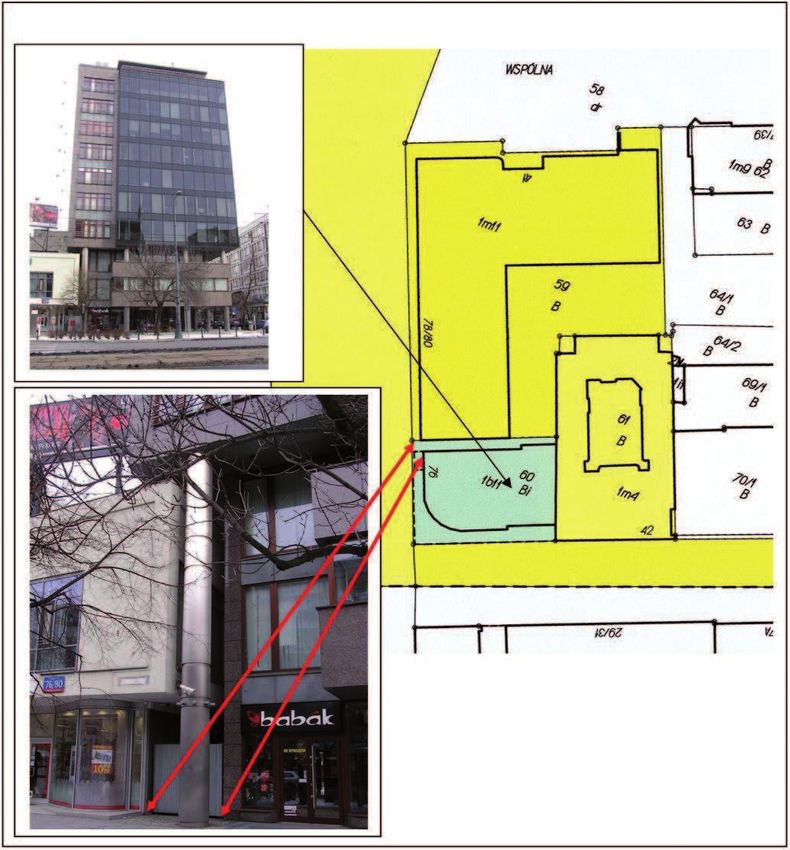
78                                       Karabin Marcin

                             Fig. 1. Test object No 1 – cadastral map
  Source: The Office of Geodesy and Cadastre for the City of Warsaw – map, photographs – author

     Complete analysis of records in the descriptive part of the cadastre as well as data
from the land register and base map performed by the author in the year 2012 show
the following:
• Cadastral parcels located within the area of the investigated object are owned by
    various owners, but all of them are public entities (owners: the State Treasury or
    the City of Warsaw, entities, which are real administrators of the real estate, are:
    the City Road Management, the Supreme Court, the President of Warsaw).
• “Conflicts” with private entities do not occur.
• There is no land register (not obligatory in Poland) for those cadastral parcels, on
    which the road is located; therefore it is not possible to register limited material
    rights for those real estates (it is important when a part of the building, the so-called,
    above-ground “connector”, is located within the space of those parcels).
• In the descriptive part of cadastre (register of the buildings) the building is registe-
    red as one object; it is also stated that the building is located also on land parcels
    No 19 and No 49/1.
• On the cadastral map two “separate” objects exist.
• As it turns out from the records in the land register for the parcels No 3/3 and No
    3/4, a telecommunication company has the right to use the underground part of the
    building, for an unlimited time, according to a specified charge; additionally, the
    parcel, under which the parking area is located (parcel No 3/4), is specified in the
    cadastre and in the land register, as “recreation area”.
• For the parcels No 19 and No 49/1 land registers have not been established; the
    analysis of the land register for the parcel No 66 does not result in any new
    information.
     The base map presents Figure 2.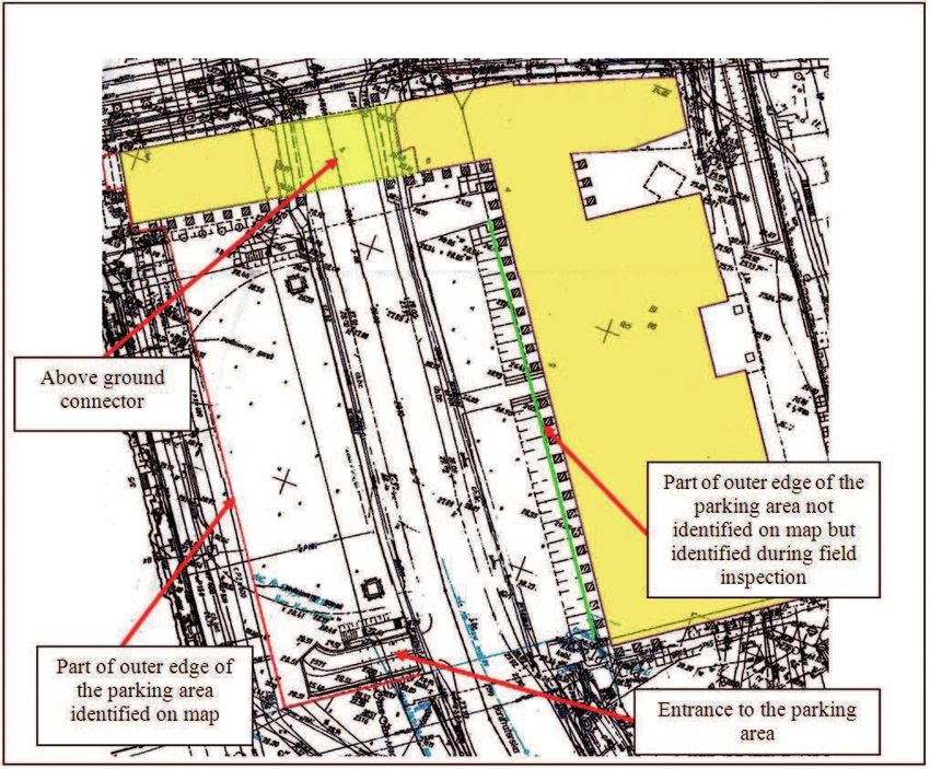
Registration of untypical 3D objects in Polish cadastre...                79

                              Fig. 2. Test object No 1 – base map
  Source: based on map from The Office of Geodesy and Cadastre for the City of Warsaw – author

     As it turns out from the performed analysis, except the information about the
existence of one, underground storey, the cadastre does not include spatial information
concerning the underground parking area. Land register does not contain information
about the underground parking area either. The same situation happens in the case of
the above-ground part of the building, located above the street. It is also not possible
to record limited material rights in the case of two parcels, on which the road is
located, since land registers have not been established for those parcels. For other
parcels, although the land registers exist, those rights have not been recorded, which
may result from the fact that all parcels belong to the “state entities”. The base map is
the source of some spatial information, but is does not present the situation related to
the underground connection between the parking area and the building. In this case,
it is not easy to identify the outer outline of the underground parking area – it is
necessary to review the design documentation.
     This case illustrates, that the base map does not always completely reflect the
spatial conditions.

                       2.2. Underground tunnel – test object No 2

The issue related to underground tunnels occur in many places of the city, but they are
not the subject of cadastral recording. This results from the fact that parcels, which are
used as roads, are the property of the state or the city. In general, the road administrator
is established, which is responsible for administration of such objects. Many of those
objects cross other objects in the space (a road on the terrain surface with a road in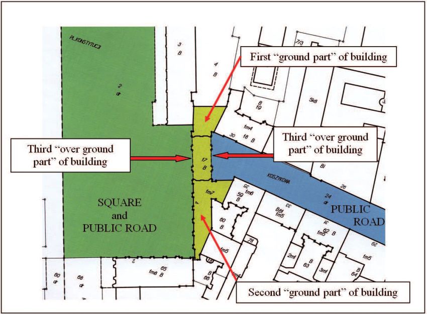
80                                       Karabin Marcin

a tunnel, a road on the terrain surface with a viaduct road etc.). For such cases, the
Polish cadastre assumes creation of separate land parcels, following the strict rules.
    In the case when railway lines, public roads, inner sea routes and inland water
routes cross each other, the following rules are applied for specification of borders of
land parcels:

• inner sea waters and inland waters, with the exception of water flowing in pipelines
  or in covered canals, are divided by railway lines and public roads into separate
  land parcels;
• railway lines divide public roads into separate land parcels;
• roads of higher category divide roads of lower category into separate land parcels;
• public roads of the same category are mutually divided into separate land parcels
  following the decisions existing in cadastral records;
• roads located on the surface divide roads in tunnels and roads on viaducts into
  separate parcels.

The example of a tunnel, which crosses the road located on the terrain surface, is the
test object No 2. Under the main thoroughfare of the city, located in the very centre
of the city (which is overloaded in rush hours), a tunnel has been built, which ensures
the collision-free entrance into traffic coming from other parts of the city, as well the
access to parking areas in front of the Palace of Culture and Science, being one of the
biggest buildings in the city centre (Figure 3).

                             Fig. 3. Test object No 2 – cadastral map
 Source: The Office of Geodesy and Cadastre for the City of Warsaw – maps, photographs – author

     The investigated object is not presented on the cadastral map, which presents the
system of parcels resulting from the above rules. The superior road, located on the
terrain surface is included in two “complete-continuous” parcels (two – as a result of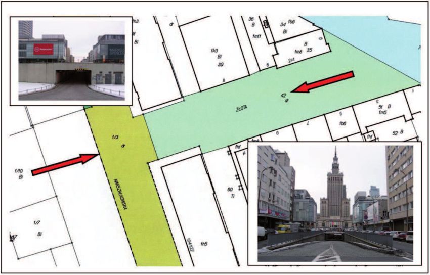
Registration of untypical 3D objects in Polish cadastre...                 81

situating the border of the cadastral district in its centre), and the road in the tunnel,
has been somehow “cut-off” as the cadastral parcel, at the joint with the surface road.
     The base map (Figure 4) presents the same boundaries of cadastral parcels, since
it contains boundaries of parcels, but additionally, it also presents the outer edges of
the tunnel, what presents the better image of the reality.

                              Fig. 4. Test object No 2 – base map
  Source: based on map from The Office of Geodesy and Cadastre for the City of Warsaw – author

                     2.3. Overlapping buildings – Test object No 3

The next example concerns two private buildings located in the centre of Warsaw. As
it turns out from the cadastral records, the building located on the land parcel No 60
does not have the underground part; it has only 11 above-ground storeys. The building
is located on the parcel of the city of Warsaw, which established the right to perpetual
lease for 11 entities, which – following legal regulations – are perpetual co-leaseholders
of the land and, at the same time, they are the co-owners of the building (a separate
building property). The cadastral map presents Figure 5.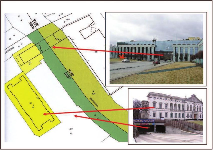
82                                       Karabin Marcin

                             Fig. 5. Test object No 3 – cadastral map
  Source: The Office of Geodesy and Cadastre for the City of Warsaw – map, photographs – author

     It turns out from the presented cadastral map, that the building from the parcel
No 59 joins the border of the parcel No 60; the same situation occurs on the field.
Following the cadastral map, the building on the parcel No 60 does not join the border
(the free space between the buildings exists). This has been also confirmed by field
inspection. The field situation corresponds to the cadastral map on the level of the first
storey of the buildings only, in the upper storeys it highly differs from the presentation
in the cadastre.
     This results from the fact that the building on the parcel No 60 is, in its above-ground
part, hanging above the building from the parcel No 59 and building on the parcel No
59 is, in its above-ground part, hanging under the building from the parcel No 60.
     The building located on the parcel No 59 is older and it may be assumed that the
owners agreed no to demolish the old building, which violated the parcel border and
to hang the new building above the existing one. Unfortunately, analysis of records
from the cadastre and from the land register has not resulted in specification of limited
material rights to the parcel, where – following the author’s opinion – the building
enters the parcel’s space somehow. Therefore, “formal” explanation of that situation
cannot be found in any of the above public registers.
     The next available document, i.e. the base map (Figure 6), also presents the di-
scussed objects.
Registration of untypical 3D objects in Polish cadastre... 83
Fig. 6. Test object No 3 – base map
Source: based on map from The Office of Geodesy and Cadastre for the City of Warsaw – author,
photograph – author
On the base map the outlines of the analysed buildings are identical with those
presented on the cadastral map, providing that the base map additionally presents the
overhang of the building from the parcel No 59 (with a dashed line). For the building
from the parcel No 60, except of the, marked in yellow (which is also visible on
the cadastral map) information concerning the part of the building hanging above the
building from the parcel No 59, is missing.
Thus, the discussed situation could not have been registered either by the cadastre,
or by the land register; it could not be presented on the base map by symbols either.
2.4. Private premises above public road – Test object No 4
The next analysed object concerns the residential building together with private pre-
mises, located in the centre of Warsaw. What is important from the point of view of
the investigated issues, is the fact that the building is partially hung over the public
road. Entrances to staircases, which lead to entrances to particular apartments, are
situated in the left and right sides of the above-ground parts of the building; they
are accessible from pavements for pedestrians, which run on both sides of the street.84 Karabin Marcin
Physical appearance of the test object no 4 is presented in the Figure 7. The cadastral
map is presented in the Figure 8.
Fig. 7. Test object No 4
Source: author
Fig. 8. Test object No 4 – cadastral map
Source: based on map from The Office of Geodesy and Cadastre for the City of Warsaw – authorRegistration of untypical 3D objects in Polish cadastre... 85
The outline of the building is registered on the map in such a way that the con-
tinuous line marks the outer outlines of the building, founded on the ground (two
parts) and the dashed line marks the part of the building, which hangs over the street.
The difficulty in interpretation of this situation, basing on the paper printout, results
from separation of the cadastral parcel along the outer outline of the building (the
building outline covers the border of the cadastral parcel – the dashed line overlaps
the continuous line, which symbolises the parcel border). In the system the building
is considered as one object, marked 1m7 (1m7 means the first building on the given
cadastral parcel, functioning as the apartment building with 7 complete above-ground
storeys). Besides, three cadastral parcels separate for each of the above parts, have not
been established.
The analysis of records in the descriptive part of the cadastre and land register
proved, that the City of Warsaw is the owner of the land parcel under the entire building
(the cadastral parcel No 17). Private individuals are owners of separate apartments
and business premises and they have the right of co-leasehold (separate shares are
determined for particular owners) in the parcel, which is the property of the City of
Warsaw. They also have the right of co-ownership of common parts of the building.
Fifty five premises have been separated so far, they were sold to private individuals.
Remaining premises are the property of the city, which administers the resources, i.e.
the President of Warsaw.
Thus, each owner of premises has the partial share in the entire cadastral parcel
(leasehold) and pays the tax for the real estate, which results from that share. The land
is utilised by all, as the commonly used public road. Owners of premises cannot use
that parcel in the same way as in the case when the parcel would be the common,
“non- road” parcel, being the common real estate (the parcel on which there is located
the building with premises). Therefore, they cannot fence that parcel or forbid entering
it. Additionally, they are imposed by discomfort resulting from the fact that the street
runs under the building (noise, pollution, poor thermal insulation etc.).
As it may be seen, the Polish cadastral system is not prepared for proper registration
of such cases. The property should be separated “vertically”, which should be compliant
with law, but it also should be just, considering taxes, which must be paid by owners
of premises (private individuals). This situation requires implementation of the 3D
cadastre in Poland.
3. Final remarks and conclusions
Research works concerning such issues as premises in the cadastre, as well as other
spatial objects has been conducted at the Department of Cadastre and Land Manage-
ment Warsaw University of Technology.
The author performed, among other things, the analysis of existing solutions per-
formed in the field of three-dimensional (3D) cadastres in selected European Union
countries. Experiences gained in Netherlands (Karabin, 2008), Sweden (Karabin, 2007),
Denmark (Góźdź, 2008) have been reviewed. Solutions applied in the countries, which86 Karabin Marcin
are not the European Union members, i.e. Norway (Góźdź, 2008) and Israel (Karabin
2009, Karabin 2010), have also been considered.
„2nd International Workshop on 3D Cadastres”, held on 16-18 November 2011 in
Delft, the Netherlands allowed for detailed analysis of present conditions and directions
of development of cadastral solutions, existing in the world, related to registration of
3D objects.
Unfortunately, there are no legal regulations concerning the 3D cadastre in Poland.
However, spatial objects, such as buildings and premises, are recorded, but – as it turns
out from results of investigations performed by the author – existing ways of registration
are not satisfactory for more complex spatial objects. The way of registration of spatial
objects in the cadastre and, probably, the catalogue of those objects itself, should be
modified, according to the author’s opinion.
At present, the lack of registration of untypical objects in the cadastre is not the
subject of wide discussions in the surveyors’ society in Poland. As it is presented in
the paper, the “untypical” situations concern such public objects and parcels, where
there are no conflicts with private entities. Following the author’s opinion, the current
situation creates barriers for many investments and makes the division of space between
various owners (a public entity – a private entity, a private entity – a private entity)
impossible.
As it is seen from the analysed cases, for many of them the base map contains
sufficient information on spatial elements (projection of the plane). The way of updating
the base map may be considered as an advantage; it is performed as a result of surveys
related to the as-built investment of buildings, underground installations, as a result of
implementation surveys, performed for the needs of making documentation concerning
division an delimitation of properties, and before commencement of any investment
units. The map developed for designing purposes, is created using the base map (as
the basic material) – updated for the appropriate area. Therefore, this material is used
for implementation of various projects and the cadastral map is included in its content.
Following the author’s opinion, if Poland concerned introduction of the complete
version of the true 3D cadastre, i.e. containing spatial data about objects, which are
not the cadastral objects at present – the base map should become the basic source of
information about extent of those objects.
As said by the author (Karabin, 2011b), the content of the base map is sufficient
to identify the spatial extent of those objects in the x, y plane, and, for the technical
infrastructure installations in the vertical plane as well, since heights of particular
elements of that infrastructure (conduits, manholes etc.) are also specified. The body
which maintains the base map (the same body maintains the cadastre) has the complete
surveying documents concerning those objects in the archive.
The research proved, that introduction of the 3D cadastre in its simplified version
(3D tags), i.e. without introduction of 3D spatial parcels, is possible with relatively low
financial inputs, comparing to those required for surveying the objects from the very
beginning, since the base map and source documents contain sufficient information
concerning locations of those objects and they should be utilised for that purpose. ItRegistration of untypical 3D objects in Polish cadastre... 87
was the main conclusion in Karabin (2011b). But test objects no 3 and 4 (where two
public ownership meet in the vertical space public ownership, and public ownerships
meets private ownership) showed that only introduction of the complete version of the
so called true 3D cadastre will ensure clear vertical division of rights and extent of
rights.
Final remark is, that in Poland we should introduce 3D cadastre in future.
Acknowledgments
I wish to express my sincere appreciation to Mrs Ewa Helsztyńska. Thank You for
doing me a real favour and invaluable help with language check. I would like to thank
very much Reviewers for important comments and reviews. It is extremely kind of You
Mrs Elżbieta Bielecka to enable me to publish the results of research works in Geodesy
and Cartography semiannual journal of Committee of Geodesy of Polish Academy of
Sciences.
References
Acharya, B. (2011). Prospects of 3D Cadastre in Nepal. In Proceedings 2nd International Workshop on 3D
Cadastres – Delft Netherlands, 16-18 November 2011 (pp. 241-254). Copenhagen, Denmark: Inter-
national Federation de Geometres (FIG).
Aien, A., Kalantari M., Rajabifard A., Williamson I. & Bennett R. (2011). Advanced Principles of 3D
Cadastral Data Modelling. In Proceedings 2nd International Workshop on 3D Cadastres – Delft
Netherlands, 16-18 November 2011 (pp. 377-396). Copenhagen, Denmark: International Federation
de Geometres (FIG).
Minister of Regional Development and Housing. (2001). Decree of the of March 29th 2001 the Cadastral
Law. Warsaw: Journal of Laws on 02 June 2001, No. 38, entry 454.
Council of Ministers. (1999). Decree of the of December 30th 1999 on Classification of Fixed Assets.
Warsaw: Journal of Laws on 01 January 2000, No. 112, entry 1316.
Erba, D. & Graciani S., (2011). 3D Cadastre in Argentina: Maps and Future Perspectives. In Proceedings
2nd International Workshop on 3D Cadastres – Delft Netherlands, 16-18 November 2011 (pp15-30).
Copenhagen, Denmark: International Federation de Geometres (FIG).
Góźdź, K. (2008). Analysis of foreign solutions in the field of registration of 3D objects in the cadastre
and opportunities to implement them in Poland. Unpublished Master Thesis, Department of Cadastre
and Land Management, Faculty of Geodesy and Cartography, Warsaw University of Technology.
Guo, R., Ying S., Li L. Luo P.,&Van Oosterom P., (2011). A Multi-jurisdiction Case Study of 3D Cadastre
in Shenzhen, China as Experiment using the LADM. In Proceedings 2nd International Workshop on
3D Cadastres – Delft Netherlands, 16-18 November 2011 (pp. 31-50). Copenhagen, Denmark: Inter-
national Federation de Geometres (FIG).
Iván, G. (2011). 3D Cadastre Development in Hungary. In Proceedings 2nd International Workshop on 3D
Cadastres – Delft Netherlands, 16-18 November 2011 (pp. 453-460) Copenhagen, Denmark: Interna-
tional Federation de Geometres (FIG).
Karabin, M. (2007). Analysis of existing solutions in the field of three-dimensional (3D) cadastral systems
in the European Union states (part 1). Geodetic Review, 12(2007), 4-7.
Karabin, M. (2008). Analysis of existing solutions in the field of three-dimensional (3D) cadastral systems
in the European Union states (part 2). Geodetic Review, 1(2008), 3-8.88 Karabin Marcin
Karabin, M. (2009). 3D cadastre issues using the example of solutions performed in Israel (part 1) Geodetic
Review, 12(2009), 8-13.
Karabin, M. (2010). 3D cadastre issues using the example of solutions performed in Israel (part 2) Geodetic
Review, 1(2010), 3-7.
Karabin, M. (2011a). Registration of the Premises in 2D Cadastral System in Poland. In FIG Working
Week 2011 „Bridging the Gap between Cultures”, Marrakech, Morocco, 18-22 May 2011, article no
4818 (available on www.oicrf.org). Marrakech, Marocco: International Federation de Geometres
(FIG).
Karabin, M. (2011b). Rules concerned registration of the spatial objects in Poland in the context of 3D
cadaster’s requirements. In Proceedings 2nd International Workshop on 3D Cadastres – Delft Nether-
lands, 16-18 November 2011 (pp. 433-452). Copenhagen, Denmark: International Federation de Geo-
metres (FIG).
Minister of Regional Development and Housing (2001). Decree on lands and buildings register. Warsaw:
Journal of Laws on 2 May 2001 No 38, entry 434.
Navratil, G. & Unger E., (2011). Height Systems for 3D Cadastres. In Proceedings 2nd International Work-
shop on 3D Cadastres – Delft Netherlands, 16-18 November 2011 (pp. 51-64). Copenhagen, Denmark:
International Federation de Geometres (FIG).
Polish Parliament (1989). The Act of May 17, 1989 The Geodetic and Cartographic Law. Warsaw: Journal
of Laws on 2010 No 193 entry 1287.
Polish Parliament (1964).The Act of April 23, 1964 The Civil Code. Warsaw: Journal of Laws on 1964
No 16 entry 93.
Thompson, R. & Van Oosterom P. (2011). Axiomatic Definition of Valid 3D Parcels, potentially in
a Space Partition. In Proceedings 2nd International Workshop on 3D Cadastres – Delft Netherlands,
16-18 November 2011 (397-416). Copenhagen, Denmark: International Federation de Geometres
(FIG).
Tsiliakou, E. & Dimopoulou E. (2011). Adjusting the 2D Hellenic Cadastre to the Complex 3D World
– Possibilities and Constraints. In Proceedings 2nd International Workshop on 3D Cadastres – Delft
Netherlands, 16-18 November 2011 (pp. 115-136). Copenhagen, Denmark: International Federation
de Geometres (FIG).
Vučić, N., Roić M. & Kapović Z. (2011). Current Situation and Prospect of 3D Cadastre in Croatia. In
Proceedings 2nd International Workshop on 3D Cadastres – Delft Netherlands, 16-18 November 2011
(pp. 255-270). Copenhagen, Denmark: International Federation de Geometres (FIG).
Ying, S., Guo R. Li L. & Van Oosterom P., Ledoux H., Stoter J. (2011). Design and Development of
a 3D Cadastral System Prototype based on the LADM and 3D Topology. In Proceedings 2nd Interna-
tional Workshop on 3D Cadastres – Delft Netherlands, 16-18 November 2011 (pp. 167-188). Copen-
hagen, Denmark: International Federation de Geometres (FIG).Registration of untypical 3D objects in Polish cadastre... 89
Rejestracja nietypowych obiektów 3D w polskim katastrze – czy istnieje potrzeba wdrożenia
katastru 3D?
Karabin Marcin
Politechnika Warszawska, Wydział Geodezji i Kartografii
Zakład Katastru i Gospodarki Nieruchomościami, Plac Politechniki 1, 00-661 Warszawa, Polska
e-mail: M.Karabin@interia.pl
Streszczenie
Polski system katastralny składa się z dwóch rejestrów: ewidencji gruntów i budynków (katastru nierucho-
mości) oraz ksiąg wieczystych. W ewidencji gruntów i budynków (katastrze nieruchomości) rejestrowane
są dane o położeniu (w dwuwymiarowym układzie współrzędnych), atrybuty oraz dane o właścicielach
obiektów katastralnych (działek, budynków i lokali), w księgach wieczystych oprócz danych właściciel-
skich, inne prawa do nieruchomości.
Rejestracja działki bez obiektów przestrzennych położonych na jej powierzchni nie stanowi proble-
mu. Także rejestracja budynków i lokali w typowych przypadkach nie stanowi trudności. Sytuacja staje
się bardziej skomplikowana w przypadku wielokrotnego użytkowania przestrzeni powyżej lub poniżej
powierzchni działki oraz w przypadku budynków o złożonej konstrukcji.
W artykule przedstawiono zasady związane z rejestracją nietypowych obiektów 3D położonych na
terenie miasta Warszawy. Zaprezentowano wyniki analizy zapisów dotyczących rejestracji tych obiektów
ewidencji gruntów i budynków (katastrze nieruchomości) oraz praw do nich zapisanych księgach wieczy-
stych. Artykuł stanowi kolejną część badań, w której autor stara się udzielić odpowiedzi na pytanie czy
rzeczywiście istnieje potrzeba wdrożenia katastru 3D w Polsce.You can also read