CAIRNS SHIPPING DEVELOPMENT PROJECT - Revised Draft Environmental Impact Statement Chapter B16: Climate Change and Greenhouse - Cairns Shipping ...
←
→
Page content transcription
If your browser does not render page correctly, please read the page content below
CAIRNS SHIPPING DEVELOPMENT PROJECT
Revised Draft Environmental Impact Statement

Chapter B16: Climate Change and Greenhouse
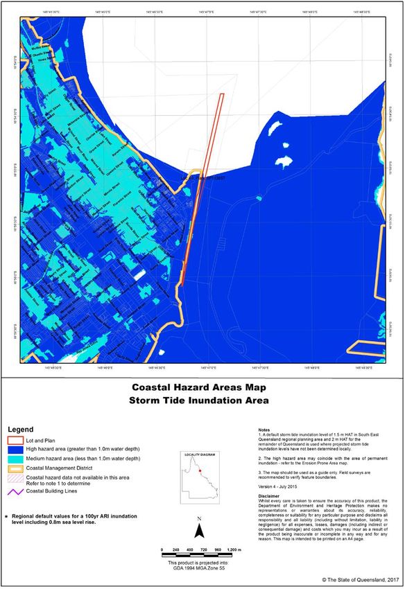
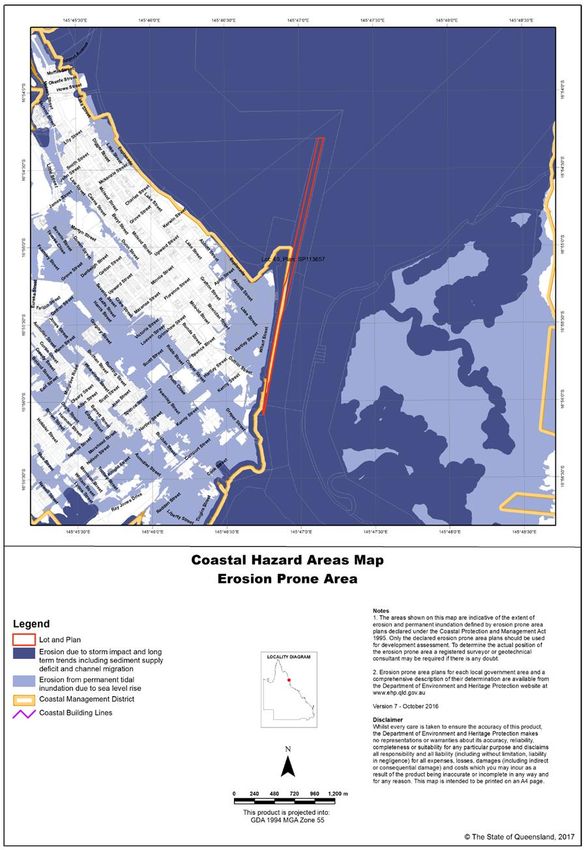
TABLE OF CONTENTS

   B16.1         Introduction................................................................................................................................................ 1
       B16.1.1         Scope .................................................................................................................................................................. 1
       B16.1.2         Study Area and Project Areas ........................................................................................................................... 1
       B16.1.3         End uses of the DMPAs ..................................................................................................................................... 3
   B16.2         Methodology .............................................................................................................................................. 4
       B16.2.1         Detailed Technical Assessments ...................................................................................................................... 4
       B16.2.2         Climate Change.................................................................................................................................................. 4
       B16.2.3         GHG Emissions .................................................................................................................................................. 5
   B16.3         Existing Situation ...................................................................................................................................... 6
       B16.3.1         Climate Change.................................................................................................................................................. 6
       B16.3.2         GHG Emissions ................................................................................................................................................ 15
   B16.4         Assessment of Potential Impacts........................................................................................................... 16
       B16.4.1         Methodology ..................................................................................................................................................... 16
       B16.4.2         Climate Change Impacts ................................................................................................................................. 21
       B16.4.3         GHG Impacts .................................................................................................................................................... 26
       B16.4.4         Ecosystem Resilience ...................................................................................................................................... 34
   B16.5         Recommended Mitigation Measures ..................................................................................................... 35
       B16.5.1         The Nature of Mitigation................................................................................................................................... 35
       B16.5.2         Climate Change................................................................................................................................................ 35
       B16.5.3         GHG Emissions ................................................................................................................................................ 36
   B16.6         Residual impacts and Assessment Summary ...................................................................................... 38
       B16.6.1         Climate Change................................................................................................................................................ 38
       B16.6.2         GHG Emissions ................................................................................................................................................ 41
       B16.6.3         Conclusion ........................................................................................................................................................ 42
   B16.7         References .............................................................................................................................................. 43

List of Figures
Figure B16-1 Study Area and Project Areas. ............................................................................................................................2
Figure B16-2 Erosion Prone Area Map – Channel and CCLT. .............................................................................................13
Figure B16-3 Storm Tide Inundation Area Map – Channel and CCLT. ...............................................................................14
Figure B16-4 Explanation of emissions categories as scopes. ............................................................................................27

                                                                                                                                                                                              (i)
List of Tables
Table B16-1 Detailed technical assessments............................................................................................................................4
Table B16-2 GWP of several GHGs ...........................................................................................................................................6
Table B16-3 Overview of IPCC emissions scenarios ...............................................................................................................8
Table B16-4 Climate change projections for the Far North Queensland area and for Australia ........................................9
Table B16-5 Significance / consequence criteria – climate change .....................................................................................17
Table B16-6 Classifications of the duration of identified impacts .........................................................................................19
Table B16-7 Likelihood of impact ..............................................................................................................................................19
Table B16-8 Risk matrix .............................................................................................................................................................19
Table B16-9 Risk rating legend .................................................................................................................................................20
Table B16-10 Significance / consequence criteria – GHG emissions..................................................................................20
Table B16-11 Potential climate change impacts to project....................................................................................................23
Table B16-12 GHG emission factors for fuel types ................................................................................................................26
Table B16-13 Construction GHG footprint scope summary ..................................................................................................28
Table B16-14 Operational GHG footprint scope summary ....................................................................................................28
Table B16-15 GHG emissions from construction phase vegetation clearing .....................................................................29
Table B16-16 Estimated construction phase GHG emissions ..............................................................................................31
Table B16-17 Estimated operational phase GHG emissions ................................................................................................33
Table B16-18 Summary of GHG emissions impact significance ..........................................................................................34
Table B16-19 Project impacts on ecosystem resilience to climate change ........................................................................34
Table B16-20 Residual risks – climate change .......................................................................................................................39
Table B16-21 Residual risk assessment – GHG emissions ..................................................................................................41

List of Charts
No table of figures entries found.

List of Photos
No table of figures entries found.

                                                                                                                                                                                   (ii)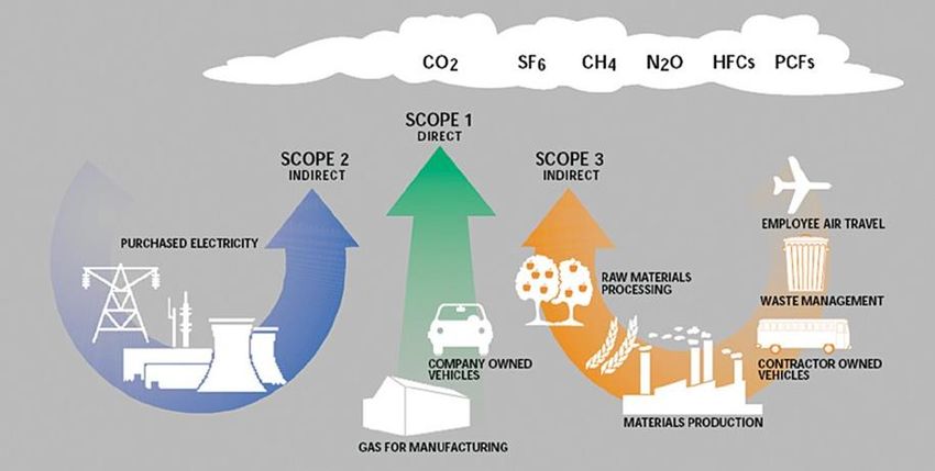
B16.1 Introduction
B16.1.1 Scope
The purpose of this chapter is to outline the potential effects of climate change on the Cairns Shipping
Development Project (the CSD Project) as well as estimating the Greenhouse Gases (GHG) that it is likely to
generate.
Specifically, this assessment is intended to:
• provide a summary of the potential effects of climate change on the project, based on current
understanding of climate change science
• provide a GHG footprint calculation for both construction and operation
• outline design and operational control measures to minimise the impacts of climate change and the
amount of GHG emissions produced.
The CSD Project is proposed to accommodate larger cruise ships at the Cairns Cruise Liner Terminal (CCLT)
and a potential expansion of the HMAS Cairns Navy Base within a nominal planning horizon (discussed in
Sections B16.2.1 and B16.2.3). Given the coastal location of the port and proposed Dredge Material
Placement Areas (DMPAs), they are expected to be vulnerable to sea level rise and storm tide events in
particular. These events are expected to be affected by changes in climate, resulting in potential impacts to the
project and/or environment. However, at the completion of the placement campaign, both DMPAs will be
subject to previously committed future uses such that long term changes arising from climate change are not
relevant. Accordingly, projected changes in climate need to be taken into consideration for the design,
operation and maintenance of the permanent landside works.
This chapter explores potential climate change impacts related to proposed infrastructure and shipping
operations, as well as considering the contribution of construction and operational activities on climate change
by accounting for the production of additional GHG emissions. These are quite different matters and are dealt
with separately below.
It should be noted that Chapter 18 (Cumulative Impacts Assessment) considers potential climate change
impacts on the Great Barrier Reef and whether the project may impact on the resilience of the marine habitat.
It also summarises consequential impacts of the project and draws from this chapter.
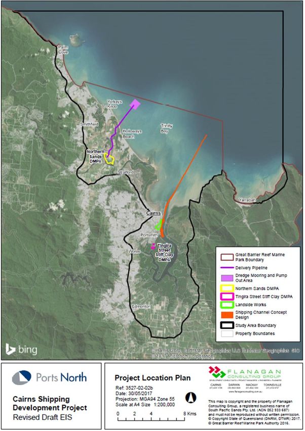
B16.1.2 Study Area and Project Areas
As noted in Chapter A1 (Introduction), the ‘study area’ for the EIS varies depending on the issue at hand while
various ‘project areas’ are the immediate footprints of the proposed works. For the consideration of climate
change and GHG emissions, the ‘local scale’ is considered to be appropriate (although climate change drivers
and the impact of GHG emissions have global dimension). Elements of the local scale (Figure B16-1) relevant
to this chapter are the Cairns coastal plain generally between the Wet Tropics World Heritage Area and the
coast between Trinity Inlet and Cairns’ Northern Beaches. This area is characterised by (from south to north):
• the Trinity Inlet wetlands
• the Cairns CBD (fronting the Cairns foreshore between Trinity Inlet and the Barron River and spreading
south-west, west, and north-west) to the coastal ranges
• the Port of Cairns and the allied industrial area east of the CBD and fronting Trinity Inlet
• the Barron River flood plain with its mosaic of agricultural, industrial, and residential developments of the
southern Northern Beaches (Machans Beach to Yorkeys Knob)
• the township of Smithfield and the balance of the Northern Beaches.
Cairns Shipping Development Project Revision: Public Issue
Revised Draft Environmental Impact Statement Date: July 2017
Document: Chapter B16 - Climate Change and Greenhouse CG - Public Issue Page B16-1 of 44
Figure B16-1 Study Area and Project Areas.

Cairns Shipping Development Project                                       Revision: Public Issue
Revised Draft Environmental Impact Statement                                    Date: July 2017
Document: Chapter B16 - Climate Change and Greenhouse CG - Public Issue       Page B16-2 of 44
Project areas are also shown on Figure B16-1 and encompass:
•       Channel Project Area including the shipping channel and the route to the pump-out point at the seaward
        end of the pipeline to the Northern Sands DMPA.
•       Landside Works Project Area for wharf upgrades and berthing of cruise ships.
•       Northern Sands DMPA Project Area (includes the DMPA, delivery pipeline corridor, tailwater ponds, and
        tailwater outlet works).
•       Tingira Street Stiff Clay DMPA Project Area.

B16.1.3           End uses of the DMPAs
B16.1.3.a         Northern Sands Project Area

The Northern Sands DMPA contains an operating sand mine and a 25 ha water-filled void that is to be
enlarged and used for the placement of soft clays pumped to the site. The current void contains fresh water
from groundwater seepage and rainfall.

The soft clay placement campaign will fill all or most of the void over a period of some three months after which
it will settle over one wet season. Once this filling is complete, the DMPA will revert to the control of the owner
who will then determine subsequent uses. No assumptions can be made about this use although current
approvals imply that at some time the void is to be completely filled.

In terms of the CSD Project, the use of the Northern Sands DMPA and the inlet and outlet pipelines will be
very short term such that any climate changes will not be relevant.
B16.1.3.b Tingira Street Project Area

The Tingira Street DMPA is currently cleared (although some marine plants have recolonised much of the area
not covered by anthropogenic grasslands) and in its past has been filled to above HAT.

The placed stiff clay will be used to fill and preload the site to accelerate settlement. As a separate project,
Ports North intends to import additional fill and construct industrial hardstands and other infrastructure. This
project has been under consideration for many years and most of the necessary approvals have already been
obtained.

In terms of the CSD Project, the use of the Tingira Street DMPA will be very short term such that any climate
changes will not be relevant.

Cairns Shipping Development Project                                                               Revision: Public Issue
Revised Draft Environmental Impact Statement                                                            Date: July 2017
Document: Chapter B16 - Climate Change and Greenhouse CG - Public Issue                               Page B16-3 of 44
B16.2 Methodology
B16.2.1 Detailed Technical Assessments
Several detailed technical assessments were undertaken in support of both the concept design of the project
(documented in Chapter A2 (Project Background)) and this chapter. These are listed in Table B16-1 below.
The final column shows where these reports are located in this Revised Draft EIS.
TABLE B16-1 DETAILED TECHNICAL ASSESSMENTS
STUDY DETAILS APPENDIX NO
Greenhouse Gas Emission Calculations Calculations of likely GHGs (prepared as part of Appendix AY
the input to Chapter B11 (Air))
This study is referred to where appropriate. While all relevant findings have been incorporated into this
chapter, readers are referred to the original report for further details if required. This technical study involved:
• calculation of emissions from clearance of vegetation using FullCAM
• preparation of a greenhouse gas inventory for combustion sources including maximum annual
greenhouse gas emissions from the proposed construction and operations based on current National
Greenhouse Accounts Factors and NGER guidelines.
• modelling of two scenarios (with and without the project) for the years 2018 and 2028.
Summaries are provided below. Many detailed tables are mentioned but not duplicated here. Readers
requiring this detailed information are referred to the relevant material where appropriate.
B16.2.2 Climate Change
The climate change assessment for the CSD Project considers the potential impacts that projected changes to
aspects of the local climate would have on the various project elements (i.e. those located in the project areas
defined in Section B16.1.2). This includes infrastructure developed or expanded by the project (e.g. expanded
Inner Harbour and Outer Harbour channel and upgraded CCLT facilities), infrastructure experiencing increased
use as a result of the project (e.g. port facilities and connecting roads) and operational activities required for or
facilitated by the project (e.g. cruise ship movements, maintenance dredging). Climate change impacts during
the construction phase are considered to be not applicable as construction will be complete before projected
changes begin to be experienced.
The description of the ‘existing situation’ for climate change involves documenting the current projections for
the Cairns region, while the assessment of impacts investigates what these could mean for the CSD Project.
The climate change assessment also includes consideration of the impact of the project upon the resilience of
the natural environment to projected changes.
B16.2.2.a End Uses of DMPAs – Climate Change Implications
End uses of the two DMPAs have been described in Sections B16.1.3.a and B16.1.3.b. It is critical to an
appreciation of impacts that the use of the two DMPAs and associated pipelines will be very short term, such
that any climate changes will not be relevant.
Cairns Shipping Development Project Revision: Public Issue
Revised Draft Environmental Impact Statement Date: July 2017
Document: Chapter B16 - Climate Change and Greenhouse CG - Public Issue Page B16-4 of 44B16.2.2.b Planning Horizon
It is assumed that the Port of Cairns will continue to be an operational port to service the city of Cairns and
surrounds, and remain a key cruise ship destination until at least 2090 (the nominal planning horizon for this
climate change assessment based on CSIRO and Bureau of Meteorology (2016a)). In regard to this, climate
change scenarios have been identified for application to 2090, with the exception of projections for rainfall
intensity (2070), storm tide inundation (2100), and tropical cyclones (2100) where projections for 2090 are not
available.
B16.2.3 GHG Emissions
The carbon footprint of the CSD Project has been calculated based on the assumption that it will be
constructed and fully operational by 2019. Refer to Chapter A3 (Project Description) for details on the project
construction process and timing.
Estimating the GHG emissions from the project includes consideration of both construction and operational
phases. Construction phase emissions are associated with emission-producing activities undertaken for the
purposes of developing the project (e.g. dredge vessel fuel use, booster pump fuel use, vegetation clearing).
Emissions during the operational phase are those that are generated by activities facilitated by or necessary
for the operation of the project (e.g. increased cruise ship movements, maintenance dredging).
The description of the ‘existing situation’ for GHG emissions involves documenting current emissions for the
Cairns region, while the assessment of impacts investigates additional emissions during the construction and
operation of the CSD Project, recognising that this is not an impact as such.
B16.2.3.a End Uses of DMPAs – GHG Implications
End uses of the two DMPAs are as described in Sections B16.1.3.a and B16.1.3.b. Construction phase
emissions for Tingira Street have not been considered in this assessment as similar activities would need to
take place to develop the land for its intended industrial use.
B16.2.3.b GHG Accounting Standards
This assessment has used two international accounting standards:
• World Business Council for Sustainable Development/World Resources Institute for Greenhouse Gas
Protocol; A Corporate Accounting and Reporting Standard (the GHG Protocol)
• AS ISO 14064.1 - 2006: Specification with guidance at the organisation level for quantification and
reporting of greenhouse gas emissions and removals (AS ISO 14064).
It should be noted that AS ISO 14064 cross-references the GHG Protocol, so these two standards are
complementary.
The National Greenhouse and Energy Reporting Scheme Measurement Technical Guidelines for estimation of
emissions by facilities in Australia (Department of the Environment and Energy 2016) references these two
international standards. Therefore, the selection of these methodologies is consistent with International and
Australian practice.
GHGs are gaseous constituents of the atmosphere that influence energy flows by absorbing infra-red radiation.
For the purposes of this report, GHGs are the six gases listed in the Kyoto Protocol: carbon dioxide (CO2),
methane (CH4), nitrous oxide (N2O), hydrofluorocarbons (HFCs), perfluorocarbons (PFCs); and sulphur
hexafluoride (SF6).
Cairns Shipping Development Project Revision: Public Issue
Revised Draft Environmental Impact Statement Date: July 2017
Document: Chapter B16 - Climate Change and Greenhouse CG - Public Issue Page B16-5 of 44As different GHGs have different Global Warming Potentials (GWP), the carbon dioxide equivalent (CO 2-e) is
used as the universal unit of measurement to evaluate GHGs against a common basis. CO 2-e indicates the
global warming potential expressed in terms of the GWP of one unit of CO 2. For that reason, CO2 is used as a
reference as it always has the GWP of one.
The GWP of a GHG is the radiative forcing impact contributing to global warming relative to one unit of CO2.
Sourced from the IPCC’s Fourth Assessment Report (Forster et al. 2007) the GWP of several GHGs are listed
in Table B16-2 below and are consistent with the Australian Government’s National Greenhouse and Energy
Reporting Measurement Technical Guidelines (DoEE 2016).
TABLE B16-2 GWP OF SEVERAL GHGS
GHGS CHEMICAL FORMULA GWP (100 YEARS)
Carbon dioxide CO2 1
Methane CH4 25
Nitrous oxides N2O 298
HFCs - 92 – 14 800
PFCs - 7390 – 12 200
Sulphur hexafluoride SF6 22 800
Source: Appendix AY (Table 1.1).
Once data is collected, emissions from an organisation’s activities are quantified by multiplying activity data
(e.g. kWh of electricity used) with the appropriate emission factor (e.g. kg CO 2 e/kWh of electricity).
Emission factors are activity-specific and thus the activity determines which emission factor is used. Identifying
the relevant emission factor can depend on several aspects including whether consumption of the input results
in GHG emissions directly or indirectly, how the input creates emissions (i.e. consumption or generation) and
the location of the activity. For example, the emission factor for the generation of electricity varies from state to
state as electricity is generated by various processes using various sources (e.g. Queensland uses a
combination of bituminous coal and natural gas/coal seam gas while Victoria predominantly uses brown coal
and in Tasmania electricity is generated by hydropower).
B16.3 Existing Situation
B16.3.1 Climate Change
B16.3.1.a Background
The Intergovernmental Panel on Climate Change (IPCC) has reported that climate changes are linked to
increased emissions of GHG caused by human activity.
Global atmospheric concentrations of carbon dioxide, methane and nitrous oxide have increased markedly
as a result of human activities since 1750 and now far exceed pre-industrial-era values determined from the
testing of ice cores spanning many thousands of years. The global increases in carbon dioxide
concentration are due primarily to fossil fuel use and land use change, while those of methane and nitrous
oxide are primarily due to agriculture. (IPCC 2007).
At the current high levels of GHG in the atmosphere, warming of the climate will continue even if emissions are
dramatically reduced. Even if emissions from human sources were to cease, slower heat loss from the oceans
means temperatures would not drop significantly for at least 1000 years.
In the 2007 Fourth Assessment Report, the IPCC recognised that ‘warming of the climate system is
unequivocal’; however, there are degrees of uncertainty associated with its impacts (when and to what extent
the impact will manifest). This uncertainty is associated with the anticipated rate of GHG emissions in the
future and correlations between temperature increases and its associated impact on sea levels, rainfall,
extreme weather etc. The latest report (IPCC 2013) confirms scientists are more certain that warming since
Cairns Shipping Development Project Revision: Public Issue
Revised Draft Environmental Impact Statement Date: July 2017
Document: Chapter B16 - Climate Change and Greenhouse CG - Public Issue Page B16-6 of 441950 has been primarily caused by humans and that the period between 2001 and 2010 was the hottest
decade on record. This is causing an increase in the frequency and severity of extreme weather events.
The latest IPCC report on climate change observations, the Fifth Assessment Report (IPCC 2013), known as
AR5, states that stabilising the climate will require substantial and sustained reductions in GHG emissions. The
report provides a view of the current state of global scientific knowledge relevant to climate change. Major
findings include:
• The period 2001-2010 was the hottest decade on record, with many regions, including Australia,
experiencing longer and more intense heatwaves. If emissions continue to track at the top of IPCC
scenarios, global temperature could rise by up to 5.4ºC by 2100, relative to pre-industrial levels.
• The frequency and severity of extreme events is increasing and rainfall patterns are changing with an
increase in the intensity or amount of heavy precipitation events, however this is subject to variation
depending on location.
• Sea level has risen by 190 mm over the 1901-2010 period, and at an increased rate over the period
since 1993, and the oceans are becoming more acidic. If emissions continue to increase unabated, sea
level is predicted to rise by nearly 1 m by 2100, compared to its average level between 1986-2005.
In their 2016 report on the State of the Climate, the CSIRO and BoM (2016b) reports the following changes for
climate change in Australia, based on the most recent observations:
• Mean surface air temperature has increased by 1.1ºC since 1910, with daytime maximum and overnight
minimum temperatures increasing by 1.0ºC and 1.2ºC respectively over this same period.
• Relative sea level has risen at an average rate of 1.4 mm/yr between 1966 and 2009 which increases to
1.6 mm/yr when the influence of El Niño Southern Oscillation is removed.
• Sea surface temperature have increased significantly.
Other observations (e.g. changes in rainfall, wind, storm frequency) have not been made for this cluster due to
unavailability of adequate historical data.
The Australian Maritime College (2009) held a workshop in 2009 to report on climate change risks for ports. In
a similar way, the National Climate Change Adaptation Research Facility (NCCARF), working with RMIT
University, undertook an extensive study to understand the future climate change risks to Australian seaports
generally (McEvoy et al. 2013). Both studies concluded that the major potential impacts on Australian ports
are:
• Increases in wind speeds and storm frequency which can damage infrastructure and affect berthing
ability of vessels. This includes impacts associated with riverine flooding as well as storm tide.
• Sea level rise – while it was agreed that sea level rise will occur gradually, allowing sufficient time to
adapt, concerns about conditions outside of ports (e.g. road/rail/electricity supply) were raised as an
issue for access/supply of ports.
• Changes in wave and atmospheric conditions, leading to reduced integrity and life of maritime structures
(e.g. increased corrosion, heat-based stress).
In this context, the project will need to take this information into account to ensure that:
• The design allows for a changing climate
• Measures to minimise the GHGs produced through its construction, operation and maintenance are
identified and implemented.
B16.3.1.b IPCC Emissions Scenarios
To estimate future climate change, the IPCC has adopted representative concentration pathways (RCPs) for
GHG concentrations in its Fifth Assessment Report (2014). These are projections describing four possible
climate futures, varying basing on GHG emissions in future years. The four RCPs are described in Table
B16-3.
Cairns Shipping Development Project Revision: Public Issue
Revised Draft Environmental Impact Statement Date: July 2017
Document: Chapter B16 - Climate Change and Greenhouse CG - Public Issue Page B16-7 of 44For purposes of this assessment, the both RPC 4.5 and RPC 8.5, representing intermediate and high GHG
concentrations, have been adopted. This is consistent with the reporting of climate futures for the Wet Tropics
cluster by CSIRO in the State of the Climate Report (CSIRO and BoM 2016a).
TABLE B16-3 OVERVIEW OF IPCC EMISSIONS SCENARIOS
RCP DESCRIPTION
RCP 2.6 Represents a GHG concentration leading to radiative forcing in 2100 relative to 1750 of 2.6 W m2. This
is a very low forcing level, based on a GHG emissions mitigation scenario where concentrations peak
and then decline before 2100.
RCP 4.5 Represents a GHG concentration leading to radiative forcing in 2100 relative to 1750 of 4.5 W m2. This
is an intermediate forcing level, based on stabilisation of GHG concentrations around 2100.
RCP 6.0 Represents a GHG concentration leading to radiative forcing in 2100 relative to 1750 of 6.0 W m2. This
is an intermediate forcing level, based on stabilisation of GHG concentrations after 2100.
RCP 8.5 Represents a GHG concentration leading to radiative forcing in 2100 relative to 1750 of 8.5 W m2. This
is a high forcing level, based on very high greenhouse gas emissions, with a concentration peak after
2100.
Source: IPCC (2014).
B16.3.1.c Climate Change Projections for Cairns
Table B16-4 presents the climate change projections used to inform this assessment and recommendations.
Projects have been primarily sourced from the CSIRO State of the Climate Report results for the Wet Tropics
cluster (CSIRO and BoM 2016a), with other projections used from well-respected sources for any relevant
gaps.
The latest report from the IPCC (AR5) provides further details regarding confidence levels; these descriptions
of confidence levels and likelihood are included in Table B16-4. The descriptions of the impacts are based on
the IPCC AR 5 Working Group II, Chapter 25 Australasia.
Cairns Shipping Development Project Revision: Public Issue
Revised Draft Environmental Impact Statement Date: July 2017
Document: Chapter B16 - Climate Change and Greenhouse CG - Public Issue Page B16-8 of 44TABLE B16-4 CLIMATE CHANGE PROJECTIONS FOR THE FAR NORTH QUEENSLAND AREA AND FOR AUSTRALIA
VARIABLE PROJECTED TIMEFRAME AND DESCRIPTION OF CONFIDENCE DESCRIPTION OF IMPACT
SCENARIO PROJECTION LEVEL
CSIRO State of the Climate Report (2016): Projections in meteorological variable change (comparative to 1986-2005 period) for Wet Tropics Cluster*
Temperature mean (ºC) 2090 – RCP 4.5 +1.4 (+1 to +2) Very high Increase in temperatures causing increased strain on
infrastructure and environmental values.
2090 – RCP 8.5 +2.9 (+2.3 to +3.9) Very high
Temperature maximum (ºC) 2090 – RCP 4.5 +1.4 (+1.1 to +2.1) Very high
2090 – RCP 8.5 +2.9 (+2.3 to +3.9) Very high
Temperature minimum (ºC) 2090 – RCP 4.5 +1.4 (+1.1 to +2.1) Very high
2090 – RCP 8.5 +3 (+2.3 to +4.2) Very high
Rainfall (%) 2090 – RCP 4.5 -2 (-12 to +8) Medium Reduction in available rainfall
2090 – RCP 8.5 -2 (-26 to +21) High
Solar radiation (%) 2090 – RCP 4.5 +0.1 (-1.6 to +2.2) Medium Increase in radiation causing increased strain on infrastructure and
environmental values
2090 – RCP 8.5 -0.3 (-4.7 to +2.2) Medium
Relative humidity (%, absolute) 2090 – RCP 4.5 -0.3 (-2.1 to +1.1) Medium -
2090 – RCP 8.5 +0.1 (-1.9 to +1.5) Medium
Potential evapotranspiration (%) 2090 – RCP 4.5 +5.1 (+3 to +9.3) Very high Reduction in available surface water
2090 – RCP 8.5 +9.8 (+5.9 to +17) Very high
Surface wind speed (%) 2090 – RCP 4.5 +1 (-1.6 to +7.1) Medium Increase in wind impacts to infrastructure and increase in wind-
generated wave impacts
2090 – RCP 8.5 +2.2 (-0.6 to +7.7) High
Soil moisture (%) 2090 – RCP 4.5 -2.7 (-12.4 to +0.4) Medium Reduction in available soil moisture
2090 – RCP 8.5 -3.9 (-19 to +3.7) Medium
(Continued over)
)
Cairns Shipping Development Project Revision: Public Issue
Revised Draft Environmental Impact Statement Date: July 2017
Document: Chapter B16 - Climate Change and Greenhouse CG - Public Issue Page B16-9 of 44VARIABLE PROJECTED TIMEFRAME AND DESCRIPTION OF CONFIDENCE DESCRIPTION OF IMPACT
SCENARIO PROJECTION LEVEL
CSIRO State of the Climate Report (2016): Projections in oceanic variable change (comparative to 1986-2005 period) for Cairns*
Sea level rise (m) 2090 – RCP 4.5 +0.48 (+0.31 to +0.65) Very high Pressures on coastal infrastructure and environmental values
2090 – RCP 8.5 +0.65 (+0.44 to +0.87) Very high
Sea allowance (m) 2090 – RCP 4.5 +0.57 n/a
2090 – RCP 8.5 +0.79 n/a
Sea surface temperature (ºC) 2090 – RCP 4.5 +1.3 (+1.1 to +1.8) Very high Increase in temperatures causing increased strain on
infrastructure and environmental values.
2090 – RCP 8.5 +2.6 (+2.3 to +3.5) Very high
Sea surface salinity 2090 – RCP 4.5 -0.13 (-0.67 to +0.27) Low Reduction in oceanic salinity and acid balances causing increased
strain on environmental values
2090 – RCP 8.5 -0.18 (-1.10 to +0.36) Low
Ocean acidification 2090 – RCP 4.5 -0.14 (-0.15 to -0.14) Very high
2090 – RCP 8.5 -0.31 (-0.32 to -0.31) Very high
Aragonite saturation 2090 – RCP 4.5 -0.77 (-0.79 to -0.73) Very high
2090 – RCP 8.5 -1.53 (-1.61 to -1.49) Very high
(Continued over)
Cairns Shipping Development Project Revision: Public Issue
Revised Draft Environmental Impact Statement Date: July 2017
Document: Chapter B16 - Climate Change and Greenhouse CG - Public Issue Page B16-10 of 44VARIABLE PROJECTED TIMEFRAME AND DESCRIPTION OF CONFIDENCE DESCRIPTION OF IMPACT
SCENARIO PROJECTION LEVEL
Other projections
Rainfall intensity 1 2070 Increase in rainfall intensity Medium Increased extreme rainfall related to flood risk
2
Storm tide inundation 2100 Storm tide level of: Medium Flood risk projected to increase due to more intense extreme
2.88 m AHD without wave rainfall events
effects
4.04 m AHD with wave
effects
Tropical cyclones 3 2100 Increase in intensity of 10% Low Tropical cyclones are projected to increase in intensity
Uncertainty in changes of
frequency
Source: Various – see below :
*Projection is described based on the median (50th percentile) with 10th and 90th percentile ranges provided in brackets (where available), except for sea level rise where 5th and 95th
percentile ranges are provided
1 Queensland Government 2016 draft Climate Change Projections for Far North Queensland Region – https://www.qld.gov.au/environment/climate/projections/
2 Cairns Storm Tide Study (BMT WBM 2009 and 2013)
3 Coastal Hazards Technical Guideline (EHP 2013)
Cairns Shipping Development Project Revision: Public Issue
Revised Draft Environmental Impact Statement Date: July 2017
Document: Chapter B16 - Climate Change and Greenhouse CG - Public Issue Page B16-11 of 44B16.3.1.d Sea Level
Existing and projected Levels
The following levels derived from the Cairns tide gauge (100280) and the Cairns Storm Tide Study (BMT WBM
2013) are relevant to the study area:
• Existing situation:
- HAT – 1.86 m AHD (3.50 m LAT)
- present day 100 yr ARI storm tide (without wave effects) – 1.99 m AHD
- present day 100 yr ARI storm tide (with wave effects) – 3.15 m AHD
• Projections for year 2100:
- 2100 100 yr ARI storm tide (without wave effects) – 2.88 m AHD
- 2100 100 yr ARI storm tide (with wave effects) – 4.04 m AHD.
Terms referred to above are as follows:
• HAT = Highest Astronomical Tide
• LAT = Lowest Astronomical Tide
• AHD = Australian Height Datum (approximately mean sea level)
• ARI = Average Recurrence Interval (years). This is approximately the inverse of Annual Exceedance
Probability which is the probability of an event being exceed in any one year.
All four of these parameters can be expected to vary with climate change.
Spatial Effects
The Queensland Government has mapped coastal hazard areas along the Queensland coast. The maps
indicate the extent of coastal areas projected to be at risk from coastal hazards to the year 2100. Each map
shows areas at risk from:
• Coastal erosion and permanent inundation by sea level rise
• Storm tide inundation for medium hazard and high hazard inundation.
The maps incorporate a sea level rise of 0.8 m by 2100 as a default for both erosion prone areas and storm
tide inundation areas. This is approximate to the sea level allowance recommended by CSIRO for the Wet
Tropics by 2090 for RCP 8.5 (0.79 m, see Table B16-4). In addition, more detailed methodologies available for
determining these risk areas (i.e. Coastal Hazards Technical Guideline EHP 2013) require adoption of a sea
level rise component of 0.8 m, a southward latitude shift in the tropical cyclone climate of approximately 1.3
degrees, and an increase in cyclone maximum potential intensity of 10% by 2100. These are derived from
projections in the Fourth Assessment Report (IPCC 2007) which remain largely unchanged in the Fifth
Assessment Report (IPCC 2014).
Figure B16-2 shows areas in the Cairns CBD and Port subject to erosion and permanent tidal inundation due
to sea level rise, in accordance with the Coastal Protection and Management Act 1995 (Qld) (CPM Act).
Figure B16-3 shows that this area is likely to be subject to storm tide inundation of greater than 1.0 m in depth,
based on current assessments. As previously noted, both DMPAs and the associated pipelines are short term
uses that will not be affected by climate change.
Cairns Shipping Development Project Revision: Public Issue
Revised Draft Environmental Impact Statement Date: July 2017
Document: Chapter B16 - Climate Change and Greenhouse CG - Public Issue Page B16-12 of 44Figure B16-2 Erosion Prone Area Map – Channel and CCLT. Source: CPM Act mapping. Cairns Shipping Development Project Revision: Public Issue Revised Draft Environmental Impact Statement Date: July 2017 Document: Chapter B16 - Climate Change and Greenhouse CG - Public Issue Page B16-13 of 44
Figure B16-3 Storm Tide Inundation Area Map – Channel and CCLT.
Source: CPM Act mapping.

Cairns Shipping Development Project                                       Revision: Public Issue
Revised Draft Environmental Impact Statement                                    Date: July 2017
Document: Chapter B16 - Climate Change and Greenhouse CG - Public Issue      Page B16-14 of 44
Erosion prone area mapping indicates the vulnerability of almost all of the Port of Cairns land-side
infrastructure, including the CCLT, to erosion from permanent tidal inundation due to sea level rise. Much of
the Northern Sands DMPA is also mapped within this erosion prone area. In addition, almost all of the landside
aspects of the project area are within the medium or high storm tide inundation areas. This mapping is based
on a default storm tide inundation level of 2.0 m at highest astronomical tide (HAT). Noting the current HAT
level for the project area is ~3.5 m above lowest astronomical tide (LAT, 1.86 m AHD) this represents a storm
tide height of 5.5 m LAT (3.86 m AHD). While more detailed calculations may reduce the extent of inundation
areas, the majority of the Landside Works Project Area is vulnerable to storm tide.

B16.3.2           GHG Emissions
B16.3.2.a         Cairns Region Emissions

No data is available of current GHG emissions for the Cairns region.
B16.3.2.b         Ports North Emissions

Ports North does not currently undertake a formal annual assessment of its GHG emissions for the Port of
Cairns. However, it has implemented a number of measures to reduce the GHG emissions footprint. These
include:
•       offsetting staff air travel through Queensland Government’s travel policy requirements
•       switching its workshop fleet to lower emission fuels
•       installing energy efficient lighting and air-conditioning plant in offices
•       recycling construction and demolition waste and purchasing products with a low carbon intensity where
        possible.

Some existing activities at the Northern Sands DMPA site are expected to be a minor source of GHG
emissions. The approved redevelopment of the Tingira Street DMPA site for port purposes will also cause
some GHG emissions, although this has not yet occurred. Emissions from both of these activities are expected
to be negligible.

Both DMPA sites may also provide minor current levels of sequestration due to the presence of vegetation.

Cairns Shipping Development Project                                                              Revision: Public Issue
Revised Draft Environmental Impact Statement                                                           Date: July 2017
Document: Chapter B16 - Climate Change and Greenhouse CG - Public Issue                             Page B16-15 of 44
B16.4 Assessment of Potential Impacts B16.4.1 Methodology B16.4.1.a Overall Approach The following impact assessment has been undertaken for each of the matters described in the previous chapter. It uses the risk-based process adopted for the Revised Draft EIS as outlined in Chapter A1 (Introduction) and includes an assessment of the following: • the magnitude of impacts (significance / consequence) as discussed below • the duration of impact (from Chapter A1 (Introduction) • the likelihood of impact (from Chapter A1 (Introduction) • risk level (from Chapter A1 (Introduction). These are considered together to determine the final level of impact risk, which is defined differently for climate change and GHG. While the above approach applies equally to climate change and GHG, the two are subtly different and are therefore discussed separately. In particular, each has different: • significance / consequence descriptors • risk rating descriptions. B16.4.1.b Climate Change Impact Significance / Consequence Criteria In the case of climate change, Australian Standard/New Zealand Standard 5334-2013: Climate Change adaptation for settlements and infrastructure – a risk based approach, outlines a process for the identification and management of risks that infrastructure faces from climate change. It provides risk criteria that are utilised in this study to determine the potential risks to the project from climate change, as shown in Table B16-5. This also provides criteria for assessing the potential impact of the CSD Project upon the resilience (i.e. adaptive capacity) of the natural environment to cope with climate change effects. This approach is used below in place of the more general methodology used in other chapters of this Revised Draft EIS. Cairns Shipping Development Project Revision: Public Issue Revised Draft Environmental Impact Statement Date: July 2017 Document: Chapter B16 - Climate Change and Greenhouse CG - Public Issue Page B16-16 of 44
TABLE B16-5 SIGNIFICANCE / CONSEQUENCE CRITERIA – CLIMATE CHANGE

SIGNIFICANCE /             ADAPTIVE CAPACITY           INFRASTRUCTURE,           SOCIAL / CULTURAL           GOVERNANCE              FINANCIAL            ENVIRONMENTAL           ECONOMY
CONSEQUENCE                                            SERVICE

Very High                  Capacity destroyed,         Significant               Severe adverse              Major policy shifts     Extreme financial    Very significant loss   Major effect on the
                           redesign required           permanent damage          human health effects,       Change to legislative   loss > 90 percent.   to the environment.     local, regional and
                           when repairing or           and/or complete loss      leading to multiple         requirements.                                May include localised   state economies.
                           renewing asset.             of the infrastructure     events of total                                                          loss of species,
                                                       and the infrastructure    disability or fatalities.                                                habitats or
                                                       service                   Total disruption to                                                      ecosystems.
                                                       Loss of infrastructure    employees,                                                               Extensive remedial
                                                       support and               customers or                                                             action essential to
                                                       translocation of          neighbours.                                                              prevent further
                                                       service to other sites    Emergency response                                                       degradation
                                                       Early renewal of          at a major level.                                                        Restoration likely to
                                                       infrastructure by 90                                                                               be required.
                                                       percent.
High                       Major loss in               Extensive                 Severe adverse              Major policy shifts.    Extreme financial    Very significant loss   Major effect on the
                           adaptive capacity.          infrastructure            human health effects,       Change to legislative   loss >90 percent.    to the environment.     local, regional and
                           Renewal or repair           damage requiring          leading to multiple         requirements.                                May include localised   state economies.
                           would need new              major repair.             events of total                                                          loss of species,
                                                                                                             Full change of
                           design to improve           Major loss of             disability or fatalities.                                                habitats or
                                                                                                             management control.
                           adaptive capacity.          infrastructure service.   Total disruptions to                                                     ecosystems.
                                                       Early renewal of          employees,
                                                       infrastructure by 50-     customers or
                                                       90 percent.               neighbours.
                                                                                 Emergency response
                                                                                 at a major level.

                                                                                                                                                                                      (Continued over)

Cairns Shipping Development Project                                                                                                                                                    Revision: Public Issue
Revised Draft Environmental Impact Statement                                                                                                                                                 Date: July 2017
Document: Chapter B16 - Climate Change and Greenhouse CG - Public Issue                                                                                                                   Page B16-17 of 44
SIGNIFICANCE / ADAPTIVE CAPACITY INFRASTRUCTURE, SOCIAL / CULTURAL GOVERNANCE FINANCIAL ENVIRONMENTAL ECONOMY
CONSEQUENCE SERVICE
Moderate Some change in Limited infrastructure Frequent disruptions Investigation by Moderate financial Some damage to the High impact on the
adaptive capacity. damage and loss of to employees, regulators. loss 10-50 percent. environment, local economy, with
Renewal or repair service customers or Changes to including local some effect on the
may need new Damage recoverable neighbours. management actions ecosystems. wider economy.
design to improve by maintenance and Adverse human required. Some remedial action
adaptive capacity. minor repair health effects. may be required.
Early renewal of
infrastructure by 20-
50 percent.
Minor Minor decrease to Localised Short-term disruption General concern Additional operational Minimal effects on Minor effect on the
the adaptive capacity infrastructure service to employees, raised by regulators, costs the natural broader economy
of the asset. disruption. customers or requiring response Financial loss small, environment. due to disruption of
Capacity easily No permanent neighbours. action.Duration of Impact
Table B16-6 shows the general approach to classifying the duration of identified impacts. This applies to both
Climate Change and GHGs.
TABLE B16-6 CLASSIFICATIONS OF THE DURATION OF IDENTIFIED IMPACTS
RELATIVE DURATION OF IMPACTS
Temporary Days to months
Short Term Up to one year
Medium Term From one to five years
Long Term From five to 50 years
Permanent / Irreversible In excess of 50 years
Likelihood of Impact
Likelihood of impact is described in Table B16-7 below. This applies to both Climate Change and GHGs.
TABLE B16-7 LIKELIHOOD OF IMPACT
LIKELIHOOD OF IMPACTS RISK PROBABILITY CATEGORIES
Highly Unlikely Highly unlikely to occur but theoretically possible
Unlikely May occur during construction of the project but probability well below 50%; unlikely,
but not negligible
Possible Less likely than not but still appreciable; probability of about 50%
Likely Likely to occur during construction or during a 12 month timeframe; probability greater
than 50%
Almost Certain Very likely to occur as a result of the proposed project construction and/or operations;
could occur multiple times during relevant impacting period
Risk Matrix
Risk is described as the product of likelihood and consequence as shown in Table B16-8 below. This applies
to both Climate Change and GHGs.
TABLE B16-8 RISK MATRIX
LIKELIHOOD SIGNIFICANCE
NEGLIGIBLE MINOR MODERATE HIGH VERY HIGH
Highly Unlikely/ Rare Negligible Negligible Low Medium High
Unlikely Negligible Low Low Medium High
Possible Negligible Low Medium Medium High
Likely Negligible Medium Medium High Extreme
Almost Certain Low Medium High Extreme Extreme
Cairns Shipping Development Project Revision: Public Issue
Revised Draft Environmental Impact Statement Date: July 2017
Document: Chapter B16 - Climate Change and Greenhouse CG - Public Issue Page B16-19 of 44The rating of risk as assessed above is as described in Table B16-9 below. This table has components that
are applicable to both Climate Change and GHGs.
TABLE B16-9 RISK RATING LEGEND
RISK RATING DESCRIPTION
Extreme Risk An issue requiring change in project scope:
• almost certain to result in unacceptable impacts to project infrastructure and/or sensitive
receptors in the natural environment of the project area, OR
• almost certain to result in unacceptable GHG emissions (bringing emissions for the port
above NGER targets)
High Risk An issue requiring further detailed investigation and planning to manage and reduce risk
• likely to result in unacceptable impacts to project infrastructure and/or sensitive receptors in
the natural environment of the project area, OR
• likely to cause a significant increase in GHG emissions (bring emissions for the port in
excess of 50% of NGER targets)
Medium Risk An issue requiring project-specific controls and procedures to manage impacts and/or
emissions
Low Risk Manageable by standard mitigation and similar operating procedures
Negligible Risk No additional management required
B16.4.1.c GHG Emissions Significance / Consequence Criteria
Impact Significance / Criteria
For the purposes of quantifying the likely impact and risk of the proposed project as a result of generated GHG
emissions (in construction and operation), significance / consequence criteria have been developed to allow a
ranking of impacts and risks in order of severity. The significance / consequence criteria have been based on
the reporting thresholds set by the National Greenhouse and Energy Reporting Act 2007 (NGER Act).
It should be noted that the GHG emissions generated from current cruise shipping facilities at the Port of
Cairns (e.g. electricity usage of facilities, fuel use for fleet) do not trigger the NGER Act and its reporting
requirements. It should also be noted that the facilities under the control of Ports North are only a small subset
of the overall port. However, for the purposes of developing criteria for the risk assessment of GHG emissions,
the NGER Act reporting thresholds for the whole port have been adopted. This is presented in Table B16-10.
TABLE B16-10 SIGNIFICANCE / CONSEQUENCE CRITERIA – GHG EMISSIONS
IMPACT SIGNIFICANCE / DESCRIPTION OF SIGNIFICANCE
CONSEQUENCE
Very High GHG emissions from a particular activity exceed the NGER Act corporate group threshold of
50 kilotonnes of CO2-e
High GHG emissions from a particular activity exceed the NGER Act facility threshold of
25 kilotonnes of CO2-e
Moderate GHG emissions from a particular activity are at least 50 per cent of the NGER Act facility
threshold of 25 kilotonnes of CO2-e
Minor Activity generates GHG emissions, but is below 50 per cent of the NGER Act facility threshold
of 25 kilotonnes of CO2-e
Negligible Activity has negligible GHG emissions, i.e. less than 1 kilotonne CO2-e
Beneficial Activity sequesters or offsets GHG emissions, such as generating renewable energy
Source: NGER Act Reporting Thresholds (NGER Act).
Cairns Shipping Development Project Revision: Public Issue
Revised Draft Environmental Impact Statement Date: July 2017
Document: Chapter B16 - Climate Change and Greenhouse CG - Public Issue Page B16-20 of 44Duration of Impact Duration of impact is described in Table B16-6 above. This applies to both Climate Change and GHGs. Likelihood of Impact Likelihood of impact is described in Table B16-7 above. This applies to both Climate Change and GHGs. Risk Matrix Risk is described as the product of likelihood and consequence as shown in Table B16-8 above. This applies to both Climate Change and GHGs. Risk Rating The rating of risk as assessed above is as described in Table B16-9 above. This table has components that are applicable to both Climate Change and GHGs. The Role of Mitigation In accordance with the adopted impact assessment process, impacts are assessed below in the absence of mitigation. Recommended mitigation actions are described in Section B16.5 and mitigated impacts assessed in Section B16.6. Certain actions (i.e. such as rehabilitation of cleared areas and standard construction management) are assumed to be in-scope (i.e. not a mitigation recommendation). See ‘Assumptions’ below. B16.4.2 Climate Change Impacts B16.4.2.a Types of Impacts Table B16-11 below provides an assessment of the potential impacts of climate change on all elements of the project, using the consequence and likelihood ratings from Table B16-5 and Table B16-7. The table considers the potential impacts to new or refurbished infrastructure and services only, without mitigation measures being applied. The climate variables considered include the following, derived from Table B16-4: • sea level rise • change in annual average temperature, relative humidity, rainfall, evaporation and wind speeds • sea level temperature rise • ocean acidification • change in rainfall intensity • change in storm tide inundation levels • change in tropical cyclone intensity and frequency • change in annual occurrence of days >35ºC. Not all of these variables will be relevant to each element of the project. B16.4.2.b Landside Works Project Area The existing wharves at the CCLT have a deck level of 3.26 m AHD, providing a freeboard of 1.4 m on the existing HAT (1.86 m AHD) and 0.11-1.27 m on the 100 yr ARI storm tide (depending on wave effects). As listed in Table B16-4 the local sea level allowance for Cairns by 2090 is 0.79 m on HAT, representing a new HAT of 2.65 m AHD, providing a reduced freeboard of 0.61 m. Freeboard above the 100 yr ARI storm tide by 2100 will be 0.38 m without wave forcing, with the wharves expected to be overtopped where wave forcing does occur. Refer to Chapter B3 (Coastal Processes) and Chapter B17 (Hazard and Risk) for further description of these terms and concepts. Cairns Shipping Development Project Revision: Public Issue Revised Draft Environmental Impact Statement Date: July 2017 Document: Chapter B16 - Climate Change and Greenhouse CG - Public Issue Page B16-21 of 44
As the Port of Cairns is located in a cyclone-prone area, existing arrangements are in place for response to
storm tide events, as per the Extreme Weather and Cyclone Contingency Plan. This plan will require
progressive updates to account for realisation of climate change projections during the planning horizon but is
considered to be appropriate for the purposes of present conditions.

In considering impacts from storm tide, and rainfall-induced flooding) it is noted that the CCLT wharves will be
retained at a height of 4.9 m LAT (3.26 m AHD). On the basis of these levels, the CCLT wharves are not
expected to be overtopped during storm tide or sea level rise events, except where wave forcing applies to the
100 yr ARI storm tide event (see Section B16.3.1.d).

NOTE: Future additional maintenance dredging associated with the CSD Project is considered to be negligible
(expected to be between 2% and 6%) and will continue to occur at the existing sea disposal site. This is
discussed further in Chapter A3 (Project Description).

In the context of impacts linked directly to a change in tropical cyclone intensity and frequency, likelihood of
risk has been identified as ‘possible’. This is considered precautionary, due to the uncertainty of climate
science in regards to impacts of tropical cyclones.

One of the key risks identified by the assessment is the permanent inundation of berthing structures due to sea
level rise. Based on current sea level projections within the planning horizon (and beyond) described in Table
B16-4, this impact will not occur. If these sea level projections change, however, this risk may become
relevant.

The risk assessment indicates the potential for significant impact to infrastructure caused by an increase in
tropical cyclone frequency and/or intensity. Climate science around cyclone intensity has a high degree of
uncertainty, and further study is required to confirm the impact of climate change on cyclone frequency in
Queensland. Cairns is already in a cyclone prone area, and the existing CCLT infrastructure is designed in
accordance with appropriate standards. Nevertheless, ongoing monitoring of cyclone risk will be required,
using the latest available climate change projections, as well as regular review of cyclone/storm event
procedures. Strengthening of infrastructure may be required at some time in the future. Surrounding
infrastructure, including power and transport networks, may be disrupted during a tropical cyclone, however,
which may in turn impact the ability to service incoming ships until repairs can be made.

In the event of a cyclone, Maritime Safety Queensland (MSQ) and the Regional Harbour Master (RHM) direct
shipping traffic, including cruise ships. An Extreme Weather Contingency Plan (MSQ 2016) has been prepared
for the Port of Cairns, which sets out cyclone response procedures. Large vessels, such as cruise ships, are
directed out to sea and the port is close. It will not reopen until the RHM is satisfied that the pilotage area is
safe for vessels to re-enter. Structural assessments of wharf infrastructure are undertaken before the port is
declared reopened. It is expected that contingency planning will be adapted over time as required.
B16.4.2.c         DMPAs

As noted above, the use of the two DMPAs and associated pipelines will be very short term, such that any
climate changes will not be relevant.
B16.4.2.d         Climate Change – Risk Assessment

Refer to Table B16-11 below.

Cairns Shipping Development Project                                                              Revision: Public Issue
Revised Draft Environmental Impact Statement                                                           Date: July 2017
Document: Chapter B16 - Climate Change and Greenhouse CG - Public Issue                             Page B16-22 of 44
You can also read