CAMBRIDGE SOUTH Transport Strategy - Vectos
←
→
Page content transcription
If your browser does not render page correctly, please read the page content below
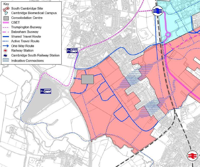
CAMBRIDGE SOUTH
    Transport Strategy

          Vectos
        April 2021
ii

Contents
1    Introduction .............................................................................................................................................................. 1
2    In a city context........................................................................................................................................................ 5
3    In a South Cambridge context............................................................................................................................... 8
4    In a CBC context ................................................................................................................................................... 15
5    Masterplan and mobility ....................................................................................................................................... 20
6    The Trip Budget..................................................................................................................................................... 35
7    Key Findings and Next Steps .............................................................................................................................. 39

South Cambridge, Transport Vision & Strategy                                                                                                              vectos.co.uk
1

1        Introduction
         Overview

1.1      The expansion of the Cambridge Biomedical Campus (CBC) is a unique opportunity.

1.2      It is unique because it has all the ingredients necessary to provide globally and locally significant
         growth whilst reducing carbon emissions and improving healthy living.

1.3      It can do this because it has the following converging attributes:

         — A move away from the largely single employment hub at CBC, widening the variety of
           commercial and research facilities which will interact at the local level, reducing the need
           to travel.

         — Providing homes that support employment at CBC, substantially increasing the opportunity
           for local working and local living, changing previously car dominated travel patterns to
           more sustainable modes.

         — Creating a well-balanced community, supported by a Community Concierge team as part of
           the wider estate management, that maximises the benefits of the interacting facilities and
           homes. This includes localising the major reasons for travel, adding education and leisure,
           and providing for ‘virtual accessibility’ including local work hubs, Mobility Hubs and ‘online
           plus deliveries’ accessibility.

         — Investing in a primary movement network based on active travel, creating permeable and
           connected neighbourhoods.

         — The existing wider area has excellent active travel and shared travel facilities, including the
           Trumpington Park and Ride, Hub, Babraham Road Park and Ride, the Busway
           (incorporating active travel), the Hills Road cycle route, the Melbourn Greenway and the
           Genome National Cycle Route.

         — A substantial investment is underway in longer distance active travel routes and shared
           travel facilities, including Cambridge South station, the Cambridge South East Transport
           corridor and Travel Hub, the South West Travel Hub, and East West Rail.

         — The opportunity to rationalise the existing CBC operation, and also the committed
           expansion, by removing the need to implement planned car parking within the campus,
           reallocating some parking to the dedicated CBC smart Travel Hubs, upgrading cycle
           facilities and reallocating road space.

         — The opportunity to rationalise deliveries from the strategic road network into a Micro
           Consolidation Centre for onward delivery to homes and businesses throughout Cambridge
           South by clean and less intimidating vehicles.

South Cambridge, Transport Vision & Strategy                                                        vectos.co.uk
April 2021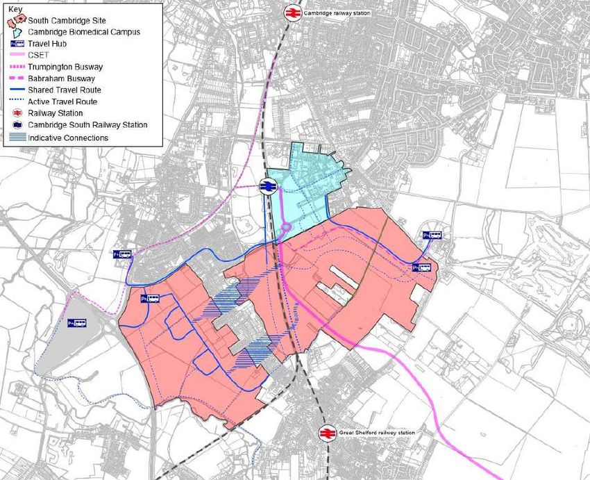
2

1.4      In 2021 the CBC Vision 2050 was prepared which sets out a clear vision for the growth and success
         of CBC over the next 30 years. The Cambridge South proposal responds to that vision and the
         understood need to support further growth opportunities for CBC.

1.5      The CBC Vision 2050 is:

1.6      “Cambridge Biomedical Campus will be globally leading and locally rooted, the preferred destination
         for Life Sciences, where research, commercialisation and real-world application come together to
         create life-saving innovation in a vibrant local community.”

1.7      To achieve this vision, it is important to understand CBC as a maturing neighbourhood with an
         aspiration of achieving its potential as a world class science hub and becoming an established
         district. The aspiration will require growth beyond the existing site boundaries.

1.8      This report outlines the vision for the future mobility for Cambridge South to match the sustainability
         objectives of the CBC Vision 2050. This vision responds to the massively changing attitudes towards
         mobility and how technology, investment and local living are changing the face of accessibility, travel
         and transport.

1.9      The land being promoted through the Local Plan comprises land within a study area immediately
         south of CBC, within which two development zones have been identified: ‘the East development zone
         immediately south east of CBC and the West development zone west of Cambridge Road. Together,
         the zones offer the opportunity to respond to the growing needs of CBC in a mixed-use sustainable
         development.

1.10     The proposed development zones are shown in Figure 1.1.

       Figure 1.1 – Location of Cambridge South

South Cambridge, Transport Vision & Strategy                                                      vectos.co.uk
April 2021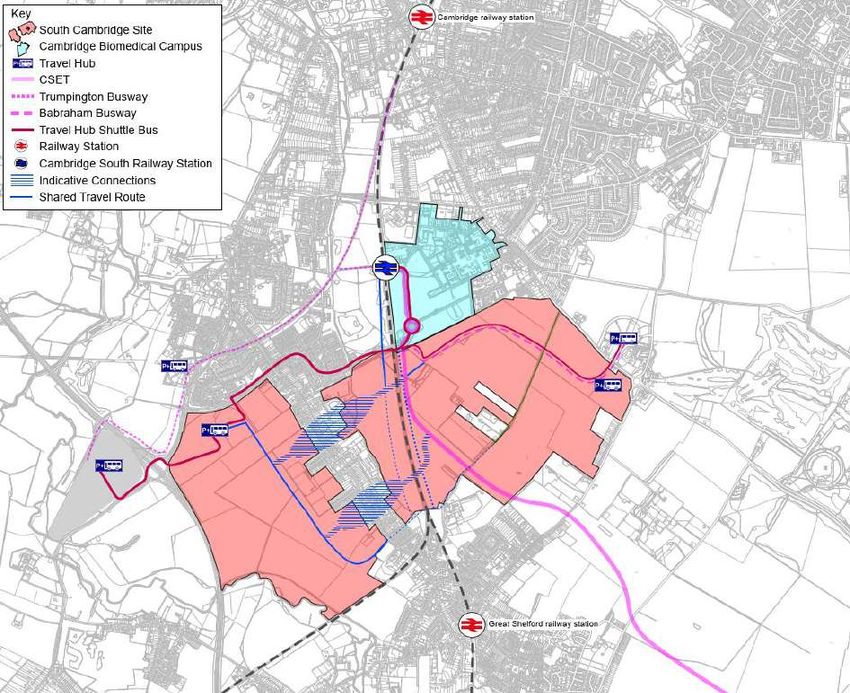
3

1.11     This Mobility Vision and Strategy forms part of a submission by the landowners of the study area to
         the Great Cambridge Local Plan.

         Development proposals summary

1.12     The proposals for Cambridge South that are set out at this time are not definitive but respond to the
         identified need for the expansion of the Biomedical Campus. Those precise needs may evolve over
         time but a draft central proposal has been developed on behalf of the landowners, in consultation
         with CBC. Further detail will be developed in due course as the Masterplan for the site evolves and
         as discussions with the local planning authority, the local community and other stakeholders take
         place.

1.13     This Vision summarises how balanced land use and innovation, placemaking and mobility can work at
         Cambridge South to realise these ambitions. It is aspirational but deliverable.

1.14     The key land uses that are being proposed are:

         — Research and Development uses to expand and reinforce CBC’s status as a global leader
           in Life Sciences;

         — Clinical uses to expand the scale and range of hospital services;

         — Up to 5,000 homes of which 40% will be affordable, and many of which will be tied directly
           to employment at CBC. The homes will be planned and marketed to meet the needs of
           CBC, including Addenbrookes, the Royal Papworth Hospital and the growing hospital
           cluster;

         — New primary and secondary schools, noting that travel to education is the major reason for
           travel in the UK at present; and

         — Open space, recreational, hotel and leisure facilities. Travel for leisure is the next most
           significant reason for travel in the UK today, and local facilities including enhanced access
           to the countryside as well as sports facilities and catering facilities can be provided to
           significantly reduce the need to travel and at the same time respond to CBC’s vision to
           promote healthy living.

1.15     The wide mix of development proposed will foster a community based on local living, social
         interaction and non-car travel by providing homes and a range of day-to-day leisure, supporting and
         recreational facilities which are currently missing from the campus.

1.16     Cambridge South provides the opportunity for existing employees and visitors to use and choose
         more sustainable and space efficient travel.

South Cambridge, Transport Vision & Strategy                                                     vectos.co.uk
April 2021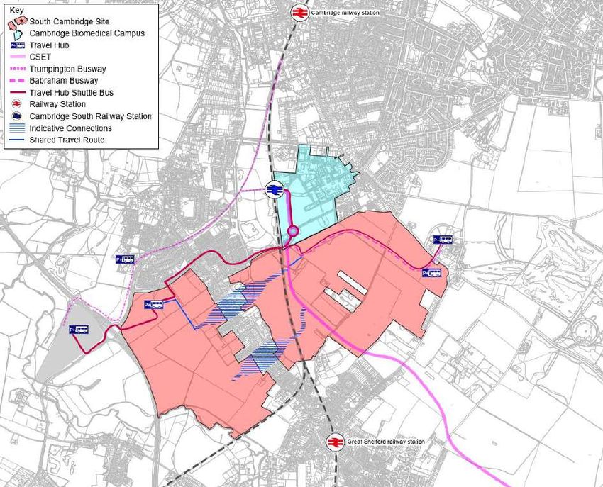
4

         Report Structure

1.17     The remainder of this report is structured as follow:

         — Section 2 – Sets out the key approach and challenges of local authorities in respect of
           mobility;

         — Section 3 – outlines the mobility opportunities in the South Cambridge area;

         — Section 4 – outlines the current context of CBC including staff numbers, baseline mode
           splits and mobility options

         — Section 5 – outlines the Masterplan and the key mobility principles. Proposed access and
           linkages are identified;

         — Section 6 – Considers the effect of the development upon the Trip Budget with reference
           to trip forecasts and modelling; and,

         — Section 7 – summarises and outlines the next key steps.

South Cambridge, Transport Vision & Strategy                                              vectos.co.uk
April 2021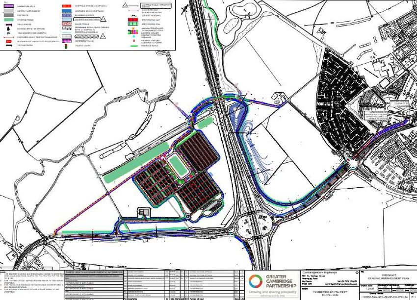
5

2        In a city context
2.1      Cambridge is part of the Oxford-Cambridge Arc, which the National Infrastructure Commission (NIC)
         has identified as an area with particular economic potential.

2.2      The identification of the Oxford-Cambridge Arc region as a growth opportunity of national
         significance by the Government has resulted in its intention to adopt an Oxford-Cambridge Arc
         Spatial Framework by the end of 2022 to stimulate and guide investment. Early reports associated
         with the framework identify the need for investment in connectivity and accessibility to housing.
         Without this, longer journeys to work and may result. Cambridge South can contribute positively
         within this framework.

2.3      The Cambridgeshire and Peterborough Independent Economic Review (CPIER) Final Report (2018)
         sets out a series of recommendations that ‘reflects the goal of doubling the size of the Combined
         Authority economy.’ The report concludes that ‘improvements in infrastructure, and further
         development, must start in and around Cambridge’.

2.4      The importance of transport is identified in the report where Recommendation 7 identifies that such
         measures ‘should include the use of better digital technology to enable more efficient use of current
         transport resources.’

2.5      The CPIER report highlights the issues associated with employment growth being dislocated from
         housing and housing growth. It reports that unless transport infrastructure and housing is provided,
         the success of Cambridge may be constrained.

2.6      A new Local Plan is being developed jointly between Cambridge City Council and South
         Cambridgeshire District Council. The emerging Local Plan identifies ‘Big Themes’ on which it is to
         be based including climate change (with a commitment to net zero); biodiversity & greenspace;
         wellbeing & inequality; and ‘great places’.

2.7      The proposals for Cambridge South offer the ability to be successful against these Local Plan themes
         through the creation of a sustainable mix of uses and effective Masterplanning to optimise the
         advantages of its highly accessible location.

2.8      The key to this is enabling sustainable local living through the creation of a new 20-minute
         neighbourhood incorporating new homes, employment and leisure facilities.

2.9      Providing a full range of facilities for a living and working community will dramatically enhance the
         operation of the Campus and reduce the need to travel. This would internalise trips and make active
         travel by foot, cycle or other Micromobility solutions the obvious choice.

South Cambridge, Transport Vision & Strategy                                                      vectos.co.uk
April 2021
6

2.10      Alongside Cambridgeshire County Council, the Greater Cambridge Partnership (GCP) has
          established a City Access project which aims to enhance public transport and cycling and walking
          routes to cut congestion and improve air quality. To achieve this, it is stated that there is a need to
          reduce the number of cars on the road and create space for more sustainable transport that offers a
          real alternative to the car.

2.11      GCP recognise that ‘employment will bring new jobs and opportunities for future generations – but
          growing congestion threatens Cambridge’s future’1.

                       Figure 2.1 – Challenge for City Access Project

2.12      The key challenges highlighted are:

           — ‘How to reduce congestion to run faster, more frequent and reliable services: traffic needs
             to reduce by up to 15% on 2011 levels (that’s up to 24% on today’s levels).

           — How to pay for improved public transport, cycling and walking networks over the longer
             term, which requires investment of around £20m per year.

           — How to improve air quality as we expand the public transport network. In Greater
             Cambridge, 106 deaths per year are attributed to poor air quality’ . (GCP website)

1
    GCP Choices for Better Journeys (2019)

South Cambridge, Transport Vision & Strategy                                                        vectos.co.uk
April 2021
7

2.13     It is therefore clear that the future approach to mobility to and within Cambridge requires a step
         change away from reliance on the use of the car and on infrastructure improvements to increase
         traffic capacity. The first challenge highlights a need to reduce car use to levels below those which
         occurred almost 10 years ago.

South Cambridge, Transport Vision & Strategy                                                      vectos.co.uk
April 2021
8

3        In a South Cambridge context
3.1      Cambridge is the centre of significant investment, research and demonstration in innovative mobility
         solutions, Southern Cambridge is a particular focus with a range of committed strategic measures at
         varying stages of progress.

3.2      Cambridge South offers a unique opportunity for development. The aspirations of CBC, the local
         growth in active travel and mass transit systems, the motorway, the particularly advanced and
         advancing attitudes to mobility in this local community and the location, make this one of the best
         places for urban growth.

3.3      The provision of new homes and jobs at Cambridge South, alongside the creation of a truly
         sustainable place that provides day to day facilities locally and promotes active, healthy and clean
         travel opportunities can contribute positively towards Cambridge’s net zero carbon aspirations.

3.4      There are mobility opportunities already present within the locality of CBC and Cambridge South
         which can support the proposals for expansion of CBC. In addition, several schemes are already
         coming forward with improvements to the local area from a mobility perspective.

         Cambridge South East Transport (CSET)

3.5      The Cambridge South East Transport (CSET) project is a priority for the GCP, creating a vital link to
         ease congestion, offer sustainable travel choices, connect communities and support growth. In the
         longer term, it would form part of the Cambridgeshire Autonomous Metro, providing high-quality,
         frequent and reliable public transport across the city region.

3.6      The CSET project itself aims to provide better public transport, walking and cycling options for those
         who travel in the A1307 and A1301 corridors, improving journey times and linking communities and
         employment sites in the area south east of Cambridge.

3.7      The CSET project is split into two phases, of which Phase 2 is of more relevance to the site by
         providing Busway facilities that run through the East development zone of Cambridge South,
         combined with remote park and ride facilities enabling sustainable travel movements.

3.8      Phase 2 of the scheme involves a new public transport route from the A11 via Sawston and Shelford
         to CBC. Alongside this new public transport route will be a new active travel corridor for walkers,
         cyclists and horse riders, similar to the one along the existing guided busways.

3.9      The proposals also include a new travel hub near the A11/A1307 junction. This travel hub would be
         in addition to the existing Babraham Road Park & Ride.

3.10     A map showing the preferred route for the new public transport scheme between CBC and a new
         travel hub near the A11 is shown in Figure 3.1. The route runs via Great Shelford, Stapleford and
         Sawston before reaching the travel hub between Babraham and the A11.

South Cambridge, Transport Vision & Strategy                                                      vectos.co.uk
April 2021
9
Figure 3.1 – CSET Preferred Route (Phase 2)
(Source: https://www.greatercambridge.org.uk/transport/transport-projects/cambridgesoutheast)
(Source: https://www.greatercambridge.org.uk/transport/transport-projects/cambridgesoutheast)
3.11 The route, with connections to Babraham, the Babraham Research Campus and Granta Park, would
be a dedicated route restricted from general traffic, only interacting with other traffic at junctions.
Junctions between existing roads and the new public transport route would be controlled by traffic
lights.
3.12 At CBC, the route would run on prioritised public transport lanes on Francis Crick Avenue,
connecting to the existing Busway and enabling services to continue to the station and Cambridge
city centre via the Busway.
3.13 The Strategic Business Case for CSET states that ‘Due to the relatively scarce supply of such a
workforce, the catchment area can extend a considerable distance from the campus. Consequently,
reliable and efficient transport provision is required so that both the workforce and visitors to the
campus are able to access it by sustainable means and support it in achieving its full economic
potential’.
3.14 In addition to connecting the Travel Hub site with the Cambridge Biomedical Campus and Cambridge
City Centre, the CSET Phase 2 scheme has been designed to provide an enhanced public transport
service to wider locations e.g. Haverhill and Linton, whilst providing improved public transport
connectivity for intermediate locations on the CSET public transport route, with dedicated stops at
Sawston, Stapleford and Great Shelford.
3.15 The forecasts states that around 450 peak hour trips may be attracted to CSET. Whilst the
proportion of those trips that may be associated with CBC is not defined, some use by CBC staff and
visitors will be apparent.
South Cambridge, Transport Vision & Strategy vectos.co.uk
April 202110
Cambridge South Railway Station
3.16 Cambridge South railway station is a planned railway station located in Cambridge adjacent to
Addenbrooke's Hospital and CBC. The station will be on the Cambridge line and West Anglia Main
Line. It is planned to open in 2025.
3.17 Funding for Cambridge South station was announced in the budget of 11 March 2020. On 22 June
2020, Network Rail revealed that its preferred location for the station was at a site adjacent to CBC
and the Cambridgeshire Guided Busway crossing.
Figure 3.2 – South Cambridge railway station (Source: https://www.cambridge-
news.co.uk/news/cambridge-news/location-new-cambridge-south-railway-18468492)
3.18 The Cambridge Biomedical Campus Transport Needs Review report confirms that the new station
offers considerable potential to achieve a mode shift for workers at the Campus.
3.19 The ability for Cambridge South to provide links to Cambridge South Station are identified in this
report with active and shared travel route connecting the west side of the station with Addenbrooke’s
Road and the wider site beyond.
South Cambridge, Transport Vision & Strategy vectos.co.uk
April 202111
Cambridge South West Travel Hub
3.20 The Cambridge South West Travel Hub Project is a component of the West of Cambridge transport
package, which includes development options for new park and ride facilities that form an extension
of the Trumpington Busway, Electric Vehicle charging points and cycle parking form part of the
proposals to create a new Travel Hub for journeys approaching Cambridge from the South-West.
The creation of new Travel Hub locations, and the enhancement or upgrade of existing facilities. It
will be located at Junction 11 of the M11.
3.21 Junction 11 of the M11 is a key entry point into Cambridge. With significant growth in housing and
employment in the area, upgrading the transport infrastructure in this area and enabling transitions to
sustainable modes of travel is vital to reduce congestion and improve access into the city.
3.22 The economic case for the Hub is primarily dependent on the growth at CBC with
CBC/Addenbrooke’s passengers representing over 70% of the total passengers on the CSWTH
services, removing these trips that would otherwise have been made on the road network.
3.23 Figure 3.3 demonstrates the layout of the Cambridge South West Travel Hub, located directly to the
southwest of the proposed West development zone. Park and ride facilities are proposed which will
be connected to the city as an extension of the Trumpington Busway. Where 48% of vehicle trips
approaching CBC are from the south-west, there is significant potential for the Travel Hub to improve
access to CBC and Cambridge South. The Travel Hub will facilitate movement to CBC and is also
immediately accessible to Cambridge South and through to wider CBC destinations, providing
opportunity for last mile shared and active travel.
Figure 3.3 – Cambridge South West Travel Hub
South Cambridge, Transport Vision & Strategy vectos.co.uk
April 202112
3.24 The South West Travel Hub has been estimated to be 70% utilised by CBC staff (SW Travel Hub
Business Case). This would mean it would reduce CBC existing and committed peak demand by
about 700 vehicles penetrating along Addenbrookes Road and into the Campus.
East-West Rail
3.25 East-West Rail is a major railway project that aims to deliver connections for communities between
Oxford and Cambridge through upgrading and providing new railway infrastructure. The Bedford to
Cambridge section will follow a completely new route. The preferred route option for East West Rail
between Bedford and Cambridge was announced in January 2020 by the Secretary of State for
Transport.
Figure 3.4 – East-West Rail Stations and connections
3.26 East-West Rail will link existing stations in Bedford and Cambridge with communities in Cambourne
and the area north of Sandy and south of St Neots. The promoters suggest that this will provide fast
and affordable connections between existing stations and communities in wider locations.
3.27 Whilst the Cambridge South station proposal is a separate project being led by Network Rail, it is
expected that some East West Rail services will stop at Cambridge South station.
3.28 Accordingly, future employees at CBC and visitors will be provided with an additional sustainable
form of travel, connecting to a wider catchment area.
South Cambridge, Transport Vision & Strategy vectos.co.uk
April 202113
3.29 The preferred route option has been identified which will run to the south of Cambridge providing
direct connections into Cambridge South Station.
Figure 3.5 – Proposed East-West Route and connection to King’s Cross Line
3.30 The proposed route on the approach to Cambridge is subject to consultation which will run through
to June 2021. The proposed route would connect with the King’s Cross Line south of Harston
approaching from the west between Harlton and Haslingfield.
3.31 East-West Rail will connect Oxford, Milton Keynes and Bedford to Cambridge via Sandy/St Neots and
Cambourne where new stations will be provided. Once in place, East-West Rail will provide
connections to South Cambridge from communities such as Cambourne and Bedford which are
direct and convenient.
South Cambridge, Transport Vision & Strategy vectos.co.uk
April 202114
Cambridgeshire Autonomous Metro
3.32 The Cambridgeshire Autonomous Metro is a Cambridgeshire and Peterborough Combined Authority
initiative that would essentially see the extension of, and upgrade of Cambridge Busway connected
through a series of tunnels through the centre of Cambridge. Advanced autonomous vehicles would
provide flexible services using sustainable electric power sources.
3.33 The emerging CAM network is presented below:
Figure 3.6 – Emerging CAM network
3.34 The location of CBC as a major destination for future CAM services is clear. It is directly connected
to the Haverhill line and has easy connects to the Trumpington line and through to the city centre
and beyond.
3.35 The greater frequency of the CAM services, combined with direct seamless connection to the wider
routes to the north west and east will ensure that travel to CBC and Cambridge South is possible
from multiple directions.
3.36 The Business Case for CAM is still being developed. Whilst the CAM cannot be considered
committed or certain at this stage, its delivery would further improve mobility across and through
Cambridge and enhance connections to CBC and Cambridge South, particularly from those locations
to the north (Waterbeach) and west Northstowe and St Ives) where direct transport links are
currently not available.
South Cambridge, Transport Vision & Strategy vectos.co.uk
April 202115
4 In a CBC context
4.1 Cambridge’s economy has grown rapidly, fuelled by the development of our knowledge-intensive
specialisms. Life Sciences is pre-eminent among these, and over 30,000 people work in Life
Sciences across the public and private sectors.
4.2 CBC is at the heart of Cambridge Life Sciences and is the only place in Cambridge—or indeed the
UK or Europe—that delivers both clinical/research on-site collaboration opportunities and true
bench-to-bedside potential. It is home to a number of organisations including: Cambridge University
Hospitals NHS Foundation Trust, Royal Papworth Hospital, NHS Foundation Trust, Astra Zeneca's
headquarters, Abcam, Cancer Research UK, the university's medical school, and the UK
government's Medical Research Council.
4.3 CBC is a major destination and generator of travel demand, with around 20,000 staff currently
working on-site and 14,500 visitors to the site each day.
Existing Mode Shares
4.4 A Transport Needs Review for CBC was published by Atkins in October 2018. This demonstrated
that patient mode share is heavily biased towards single or multiple occupancy car (86% in total).
4.5 Staff mode share was shown to be relatively evenly split between cycle, single occupancy car and
bus trips, with walking trips making up a lower percentage.
4.6 Cycling was shown to account for 33% of staff travel, with bus use constituting 28% of travel. This
also includes Park and Ride use. The implication is that that there is a willingness to use public
transport where it is available 35% of staff currently use the car, which is likely to mostly represent
those travelling from outside of Cambridge or those who have shift patterns that run into the night.
How CBC staff travel to work
Public
Transport Active
28% Travel
37%
Vehicle
Drivers and
Car Sharers
35%
South Cambridge, Transport Vision & Strategy vectos.co.uk
April 202116
4.7 In terms of visitor mode share, this was derived within the report from CBC Interview Surveys
conducted in October 2017. In this survey, visitors included those that accompany patients, those
that accompany staff and those that are visiting the shops within the site. Car had the highest mode
share with 49%, with bus at 15%, cycling at 13% and walking at 11%. Train and Park and Ride made
up the remaining numbers.
4.8 CBC has a range of transport links that cater for all modes, although demand for some modes is
exceeding supply, particularly existing cycle and car parking levels and some directions are less well
served.
4.9 Census and RSI data found that CBC staff are predominantly located within the south of Cambridge,
Haverhill, surrounding south eastern Cambridgeshire villages, Cambourne, Royston and Fulbourn.
Travel to work data shows that the south is the main corridor by which commuters’ access CBC, with
88% of commuters travelling from the south east or south west (via Babraham Road and Hauxton
Road and Addenbrooke’s Road).
4.10 RSI data showed that patients tend to originate from a significantly wider area, in locations such as
Ely and Saffron Walden, but local access is consolidated and dominated by people travelling via the
southern access routes. The main purposes for travel to CBC were work (42%), other business
(including medical appointments) (39%), or personal business (10%).
Figure 4.1 – Direction of travel for staff arriving at CBC by car
4.11 The provision of new parking facilities within Cambridge South and connections to Travel Hubs can
intercept many of these vehicle movements, reducing congestion around CBC and freeing space by
reducing the need for car parking.
South Cambridge, Transport Vision & Strategy vectos.co.uk
April 202117
4.12 Alongside CBC specific bus services and parking that is directly associated with CBC, the facilities
would provide an alternative to the publicly accessible park and ride and travel hub facilities
alongside additional capacity. Over time, however, as travel connections improve further the
intention will be to further reduce car parking levels and encourage increasing mobility by other
modes.
4.13 Walking levels are reasonably low accessing the site, with a mode share of 3% for staff and 1% for
patients. On-site observations found that, although not all junctions have pedestrian priority, most do
and footways are often of an adequate width and level. The constraint, therefore, is the absence of
homes and of facilities related to the Campus within walking distance.
4.14 Cycling catchments show that most of Cambridge is within an 8.5km (circa 35 minute cycle)
catchment of CBC, with 33% of staff cycling to work and a lower mode share of 4% for patients. The
local cycling network provides reasonable links to wider infrastructure. While overall accident
numbers are low, accident data showed that 52% of local accidents involve at least one cyclist, which
may be due to large numbers travelling along Hills Road, Trumpington Road and Long Road during
peak times.
4.15 With a high mode share of 28% staff and 9% patients, there is a propensity to travel by public
transport to the Campus, which could be increased further if service improvements and increased
reliability were brought forward. The bus services around CBC cover the site with nine stops within a
1,000m (approximately 10 minute) walking catchment from the CBC centre, including the
Addenbrooke’s hospital bus station and the busway.
4.16 Bus services that visit CBC are generally cater well for the main concentrations of staff home
locations. However, services to the east, north east and west of Cambridge currently provide limited
access. The locations of the bus stops within CBC mean that staff and patients may have to traverse
the site to get to their destination as the bus service do not always stop centrally or conveniently.
Cycle parking and car parking
4.17 CBC also assesses the current performance of cycle parking on-site. Out of 19 sites, 11 sites had
more cycles parked than spaces provided. In total, there were 3,151 cycles parked in 2,973 spaces.
This deficit is due to the unofficial parking on-site and it was observed that cycles were parked on
barriers, rails and trees, therefore demonstrating that parking is over-capacity. With CBC set to grow
with additional consented floorspace, this problem needs to be addressed.
4.18 Both car and cycling parking facilities do not meet demand. CUH estimates that an additional 1,106
individuals park their cars on-street outside of CBC and walk. The current level of car parking supply
within CBC is 4,950 spaces. Data received from CBC showed that 15 of the 38 car parks are
operating over capacity, with the entire site having an occupancy level of 87.5%.
South Cambridge, Transport Vision & Strategy vectos.co.uk
April 202118
4.19 With new developments, the demand for car parking will increase (unless alternative modes are
provided) and committed developments include proposals for additional car parking. Cambridge
South can provide alternative car parking for CBC, connected to the wider site through shared and
active travel corridors which will relieve car parking pressure and congestion around the Campus.
4.20 The provision of new homes and support facilities close to the Campus will reduce the need to travel
significant distances, particularly by car. Enhanced public transport services and the implementation
of a site wide mobility strategy will assist a shift away from the use of the car, enabling car parking
numbers to be reduced over time, although the particular need for hospital parking will continue.
Local traffic conditions
8am Weekday with some congestion 12pm Weekday 5pm Weekday with some congestion around CBC
Figure 4.2 – Traffic and congestion close to CBC
4.21 The local highway network is currently operating in free flow conditions for most of the day and night,
but close to capacity during an hour in the morning and an hour in the evening which coincides with
the traditional pre Covid general commuter times. This is indicated in Figure 4.2, which is derived
from Google observed effect data.
4.22 A major benefit of developing homes at CBC, and prioritising them for CBC staff, is much greater
‘internalisation’ of travel to work movement than exists at present, with substantial comparative
reductions in carbon emissions from surface transport. The range of education, leisure and
community facilities complements this by ensuring that new residents adopt the principles of a 20-
minute settlement, and in the main stay local for day-to-day activities, with consequent benefits to
carbon reduction, as well as to mental and physical health.
4.23 Combined with measures such as consolidated car parking on the West and East sites, Cambridge
South will contribute positively to reducing movements and congestion in the area.
South Cambridge, Transport Vision & Strategy vectos.co.uk
April 202119
Looking forward
4.24 CBC’s occupiers have considered what role CBC should play in the coming decades to support
Cambridge, the UK and Life Sciences globally; the outcome of that review is Vision 2050.
4.25 CBC’s Vision 2050 recognises that the significant pressures of previous development in Cambridge
have created transport and housing issues that must be addressed head on. CBC’s further Life
Sciences development must offer healthy, diverse, and sustainable living conditions to attract and
retain talent.
4.26 The proposal for Cambridge South is prepared by the four landowners adjacent to CBC – St John’s
College, Jesus College, the private family trust and Cambridge County Council. It responds to the
need to translate the Vision 2050 into practical development.
South Cambridge, Transport Vision & Strategy vectos.co.uk
April 202120
5 Masterplan and mobility
5.1 The proposals for Cambridge South are not fixed but the principles are clear. The emerging
Masterplan provides for the components that respond to the CBC Vision for 2050 and which bring a
particularly helpful diversity of uses.
5.2 This is the best place for growth because of the unique way that it can bring together the elements
that make up a carbon reducing, healthy living, globally significant community. These are
summarised in Chapter 1.
5.3 The mobility masterplan elements that complement and make the most of these include:
— A primary movement network within the community that is the active travel network.
Movement around the sites will be predominantly by active travel or micro mobility
— A large proportion of homes provided directly for the benefit of staff at CBC, enabling them
to work and live locally. These are nurses, doctors, R&D staff, creating a vibrant,
knowledge-based community, adding to the global attraction and strength of CBC.
— New private parking will be minimal or zero.
— Excellent connections to the primary cycle network to and within Cambridge . This includes
the Busway, the Genome Route on National Cycle Route 11, Hills Road, the Melbourn
Greenway, routes along Addenbrooke’s Road through Great Shelford, and the future CSET.
The site itself provides the opportunity for greater permeability across South Cambridge .
— Excellent connections to local public transport such as existing park and ride and busway
connections provided at the Trumpington and Babraham facilities, and those proposed
through the proposals for the South West Travel Hub and CSET initiative.
— National public transport connections will be delivered through Cambridge South Railway
Station connecting destinations on the West Anglian Main Line, services to London via
Thameslink and Kings Lynn, Norwich and Ipswich.
— The design and facilitation of modern shared travel including demand responsive bus
services, shuttle connections between travel hubs which may incorporate automated pods.
— The intercept of car travel from the strategic road network. Most of the staff movement to
the existing CBC from the Cambridge direction is already by sustainable travel. Of the car
borne movement, most arrives from the M11 junction 11 or from the A1307 and the A11.
There is the most unusual opportunity to intercept these car trips through up to six Travel
Hubs. Two of these exist now (there are plans to expand the site at Babraham), another
two are planned by GCP, and a further two smart and CBC specific hubs are proposed as
part of this scheme, to both intercept cars, and replace parking that can be removed from
the existing CBC, and from the already committed expansion of CBC.
— The intercept of goods from the strategic road network for onward delivery via by more
efficient ‘last mile’ techniques
South Cambridge, Transport Vision & Strategy vectos.co.uk
April 202121
5.4 The Masterplan (Figure 5.1) takes advantage of the two key attributes: size and location.
Figure 5.1 – Cambridge South Masterplan
5.5 This provides:
— Employment floorspace comprising 405,057sqm GEA of clinical, research, commercial
R&D, education, supporting office and logistics spaces
— Provision of 5,000 homes
— Hotel and conference facilities
— Retail and leisure uses
— Pre-school, Primary school and Secondary schools to meet the requirements of new
residents
— Healthcare, sports, leisure and recreation and community facilities
South Cambridge, Transport Vision & Strategy vectos.co.uk
April 202122
5.6 There is a need for, and benefit from, both East and West development zones working as one.
Together they provide:
— Sufficient scale to deliver the 5,000 homes to provide for the existing and proposed
interlinked healthcare, research and commercial entities. The intention is that many homes
would be occupied by those who work at the Campus, thereby transforming the nature and
quality of their journey to work;
— Connectivity across and between all major modes of transport and facilities, embracing and
connecting with CSET, The Western Travel Hubs, the Eastern Travel Hubs, the Busway;
— Direct segregated active travel corridors within the development but also reaching out to
connect with the southern villages and Trumpington; and
— The intercept of goods deliveries direct from the M11 by a micro consolidation centre on
the West development zone.
Mobility Hubs and Community Concierge
Figure 5.3 – Concept Primary Mobility Hub
5.7 Car free, or low car, neighbourhoods, where the primary network is the active travel network lend
themselves to a network of Mobility Hubs either Primary, Secondary or Tertiary. The masterplan
proposes a network of linked hubs.
5.8 Primary Mobility Hubs will be located in local centres and close to shared travel nodes. They will
include members of the Community Concierge team (as part of the estates management team).
South Cambridge, Transport Vision & Strategy vectos.co.uk
April 202123
Figure 5.4 – Location of Primary mobility hubs at Cambridge South
5.9 The Hubs and the Community Concierge team will provide;
— Hire bikes, cargo bikes (trials planned by GCP), e-bikes, scooters, which are currently
being trialled in the area by the Combined Authority and other forms of micro mobility;
— Pick up and drop off for parcels, encouraging online ‘travel’ and delivery, whilst providing
a focus for community interaction amongst those dropping in to pick up their parcels;
— Administering the ‘last mile of travel’ techniques for those that want their parcel delivered
to their door, including by cargo bike and ground drone such as those already in place in
Milton Keynes and Northampton;
— Providing space and tools for ‘fix your own bike’;
— Serving coffee and cakes;
— Administering care share and car pooling schemes;
— Administering school and other travel planning;
South Cambridge, Transport Vision & Strategy vectos.co.uk
April 202124
— Administering the Third Places Workhubs that allow people to work remotely from home
and place of work; and
— Other community functions.
5.10 Mobility Hub are being planned for a range of emerging development proposals that Vectos are
actively working on. Examples include the Garden Town at Gilston Garden Town in Hertfordshire
and Dunton Hills Garden Village in Essex. In addition, Cambridge Science Park has implemented an
initial Mobility Hub which incorporates cycle maintenance facilities near to their Bradfield Centre Co-
working facility. Over time the offer will be expanded to form part of the wider offer within the park.
5.11 As part of the Transforming Cities Fund (TCF) grant Plymouth city Council are planning to install up
to 50 multi-modal mobility hubs. These will consist of 300 electric vehicle charging points, 400 e-
bikes, car club, 0.5 megawatts of solar carports and a smart booking system. Local residents,
employees, businesses and visitors will be able to plan their journeys to use public and shared
transportation.
5.12 A Community Concierge service has been established by Vectos at Milton Park in Oxfordshire, one
of Europe’s largest multi-use business parks with circa 250 companies. In 2016, a Behaviour Change
Advisor was appointed to work with the companies and individuals to implement a range of behaviour
change initiatives, with the objective of reducing Single Occupancy Vehicles by 2%. By 2018, the
SOV rate had reduced from 69% to 63%, while the mode shares for bus, car sharing and cycling had
all increased.
5.13 Secondary and Tertiary Hubs are planned. These would be unstaffed, with varying facilities and at
more frequent intervals.
Figure 5.5– Concept Secondary Mobility Hub
South Cambridge, Transport Vision & Strategy vectos.co.uk
April 202125
Car Parking and Car Sharing
5.14 With the unique characteristics of the site there is very little need for private car ownership, and
much reduced need from the norm for private car accessibility, particularly to individual units within
the expansion area.
5.15 The existing CBC does have a substantial proportion of car parking, some 4,950 spaces, and not
enough cycle parking, only 2,973 spaces. Furthermore, the committed development at CBC comes
with a further and substantial proportion of car parking, some 1,400 spaces.
5.16 The committed development pre-date the emerging proposals for CSET, Cambridge South Station
and the SW Travel Hub. Alongside the measures proposed for Cambridge South there is opportunity
to review the proposals for the committed schemes where parking may not need to be implemented.
5.17 The expansion scheme represents an opportunity to rationalise what happens at the existing CBC
and what is provided with the committed developments. It will be necessary to maintain sufficient
private vehicle parking for high priority uses, such as for instance patients drop off and pick up,
restricting easy parking for staff, and reallocating parking from within the campus to peripheral
parking barns, with provision for onwards travel by foot, cycle, shared or personalised transport. In
time, as mobility habits mature, the provision of parking in the barns can be further reduced.
5.18 The approach brings mobility and carbon benefits, but it also frees up the masterplan to enable car
free streets and to ensure that central space is not unnecessarily given over to extensive parking.
There will be no large surface car parks.
5.19 Initial parking standards could be as low as an average 0.1 - 0.2 spaces per dwelling, with the
majority of spaces pooled and provided peripherally. The detail is still to be considered, but these
are likely to be decked car parks, close to Primary Mobility Hubs, managed by the Community
Concierge team.
5.20 Car ownership does not necessarily equate to car usage. A balance across Cambridge South will be
achieved. The blended average across the site will result in significant areas for numbers of car free
development. New approaches to mobility are creating the confidence that households do not need
to own a car.
5.21 Both Zip car and Enterprise are already present in Cambridge providing car club services. Studies
have demonstrated that each shared car replaces between eight and eleven private cars. Car clubs
are becoming more prominent in towns and cities across the UK, and car club spaces can be located
strategically at key destinations, major employment sites, mobility hubs, and town and city centres.
The membership of car clubs is increasing, reflecting people’s changing attitudes towards Mobility.
5.22 App-based carpooling is now taking off, and lifts can be booked on demand, reflecting modern
lifestyles, removing the requirement to plan journeys well in advance to participate in an effective
carpooling system. Vectos played a leading role in the SocialCar project, an EU funded research and
innovation project, which aimed to establish carpooling as a more accessible transport mode. The
project developed and demonstrated a new mobile phone application, in ten European cities, which
allows users to find carpooling options in real-time and to connect with public transport services.
South Cambridge, Transport Vision & Strategy vectos.co.uk
April 202126
5.23 Liftshare is an online car sharing scheme. It was introduced to Johnson Matthey in Royston, a site
with over 2,000 employees, where there was significant strain on parking infrastructure. Prior to the
scheme there were a reported 980 single-occupancy vehicle trips. After the scheme, 106 employees
were sharing their commute, removing 64 single-occupancy vehicle trips from the site. This reflects a
reduction of 6.5%.
5.24 Faxi is a scheme currently in operation across the UK which aims to incentivise employees to share a
ride with co-workers. Faxi is based around a map showing users journeys, regular destination and
other community members. Icons represent other users, and the app allows users to click on the
icons to see journey requirements and use the built-in messaging system to arrange a journey. The
app calculates a fair contribution towards costs, and passengers simply pay drivers directly from the
app.
South Cambridge, Transport Vision & Strategy vectos.co.uk
April 202127
Park and Ride and Travel Hubs
5.25 Figure 5.6 shows the four existing, committed and applied for travel hubs, available to all members of
the public. Two of these are on the A10 close to Junction 11 of the M11, one is at Babraham Road,
and the other is at the A11 at one end of the committed CSET, which itself runs through the site.
5.26 The proposal is to supplement these with two further Travel Hubs, one within the East development
zone and the other within the West development zone. These can be for CBC specific use, linked to
the Primary Mobility Hubs and managed by the Community Concierge team.
Figure 5.6 – On and off-site Travel Hub connections
South Cambridge, Transport Vision & Strategy vectos.co.uk
April 202128
5.27 The masterplan proposes a new busway from the Babraham Road Travel Hub through the site.
Figure 5.7 – Babraham Busway link
5.28 The provision of a seamless, traffic-free link from the Babraham Park and ride site with Cambridge
South has the ability to maximise the attractiveness of the Travel Hub and reduce car trips into CBC
and beyond. Ensuring that bus (or future CAM services) are protected from traffic is a key advantage
that makes such services efficient and preferable to the use of the car.
5.29 Movements from the west can utilise the existing Travel Hub at Trumpington and the proposed South
West Travel Hub. The busway provides a direct route through to CBC, local shuttle services, specific
to CBC will provide connections between hubs, through the expansion land and CBC.
South Cambridge, Transport Vision & Strategy vectos.co.uk
April 202129
Micro Consolidation Centre
5.30 Micro consolidation centres work well when the area which they serve is largely managed by a single
entity, as here. Micro consolidation centres are places where goods are delivered to, for onward
delivery by more sustainable and less intrusive methods.
5.31 The masterplan includes such a centre close to the M11 junction 11 within the West development
zone, and with direct access proposed from the motorway junction.
Figure 5.8– Location of Consolidation centre
5.32 The new homes will all be able to utilise the micro consolidation offer. New employment and
commercial schemes that are implemented will also be able to utilise the facility. The potential will be
investigated to extend the opportunity across CBC.
5.33 The key advantage would be the removal of vehicles required to pass through the Hauxton Road /
Addenbrooke’s Road junction and along Addenbrooke’s Road through to CBC. The west
development zone is the best place to intercept goods and private cars that are using the long
distance strategic network (M11) and convert them into the efficient and urban scale movement
networks.
South Cambridge, Transport Vision & Strategy vectos.co.uk
April 202130
5.34 By referencing the existing and forecast numbers of movements into CBC associated with heavy and
light goods vehicles, there is opportunity to intercept around 50-100 goods vehicles through the
micro consolidation centre.
5.35 To further reduce vehicle movements on Addenbrooke’s Road, a simple junction arrangement to
Hauxton Road is proposed, taking traffic directly into the western development zone. A two-stage
arrangement will provide a high-capacity junction arrangement and one that would minimise vehicle
movements on the local highway network.
5.36 The preliminary design of the junctions is provided in Appendix A.
Shared Travel
5.37 Shared travel includes buses and trains but is by no means restricted to these forms.
5.38 The proposal have the potential to build upon best practice described earlier in this section. A
detailed mobility strategy ill be prepared but potential initiatives include:
— A semi-demand responsive network, such as Zeelo, to specific towns and villages at
specific times to match staff clusters and travel and shift patterns;
— A shuttle network, connecting Travel Hubs and Mobility Hubs with CBC facilities, using the
road network. These may be autonomous, such as Easymile EZ10, in due course;
— A ‘personal pod’ network for within CBC, that is capable of operating on the ‘shared travel
routes’ with cyclists, or roads within the campus. These may be driven, or autonomous,
such as UKAutodrive connected and autonomous pavement-based pods, in due course,
and take passengers door to door;
— A substantial car sharing scheme, where the car is not owned by the individual and is
available for hire; and
— Car pooling platforms, where the car is owned by the individual, and that individual shares
rides with others, also benefitting from priority parking. This is particularly effective for
permeating rural catchments.
5.39 Low occupancy buses are climate inefficient. Therefore, the idea with any shared travel network is to
maximise occupancy, which in some cases means targeting demands, and being smart about the
size and nature of the vehicles used.
5.40 Much of the Cambridge, and CBC, hinterland is rural in nature, with small towns and villages. Semi
demand responsive services (buses or smaller vehicles) are capable of maximising occupancy by
developing routes that pick up a string of towns and villages relative to the demand. These services
are likely to be focussed on CBC staff and hospital visitors and at the times at which those staff want
to, or need to, travel. They are pre booked on a smart phone or computer. Over time, the system
learns the likely locations of demand and adjusts routes and sizes of vehicle accordingly.
South Cambridge, Transport Vision & Strategy vectos.co.uk
April 202131
5.41 Arriva Click is one example of a successful and growing demand responsive service in the UK. A
current example of Arriva Click’s success following Section 106 funding is at Lubbesthorpe near
Leicester.
5.42 Arriva Click are serving a new residential / mixed use development in Leicester at New
Lubbesthorpe. There are now some 300 houses built including a mix of social housing, flats and
houses. In the six months that the Arriva Click service has operated, 5,000 journeys have been made
to and from New Lubbesthorpe, including patronage from the adjacent communities.
5.43 In 2018 Innovate UK announced the award of £2.5 million to trial Connected Automated Vehicles
(CAVs) at Milton Park, a large employment site near Didcot. The vehicles are expected to be
operational within 12 months, and whilst initially operating within Milton Park, the intention is for
vehicles to operate between Milton Park and Didcot Parkway rail station, providing improved choice
for employees when making their daily travel decisions. Similar potential exists here at Cambridge
South.
5.44 Whilst yet to be implemented, trials of Automated Vehicles (AVs) are planned for by GCP for the
Trumpington Busway connecting the park and ride services to the railway station and CB1.
5.45 The Community Concierge team would administer these services and liaise with operators.
Figure 5.9 – Shared travel connections
South Cambridge, Transport Vision & Strategy vectos.co.uk
April 202132
Travel Data
5.46 The mobility strategy will implement a constant data collection exercise across staff, visitors,
residents and travel modes at CBC to continually inform and enable refinement of accessibility and
mobility. This is a major advantage of a single management of the campus.
The Masterplan movement network
5.47 Figure 5.10 shows an indicative network for high-capacity movement within, and across, the site.
Figure 5.10 – Mobility across Cambridge South
5.48 The highest capacity networks are the walking and cycling networks that permeate the site,
connecting West with East and the existing CBC. They can be up to nine times as space efficient as
those that carry cars. They are also non intimidating and work well passing through the open spaces.
5.49 They form direct and easy routes within the site, connecting for instance the various sectors with the
station, the travel hubs, the Mobility Hubs, the local centres, the commercial facilities, the leisure
spaces and the neighbouring communities.
5.50 The cycle facilities are largely segregated from the pedestrian facilities due to differential speeds,
except in some leisure and shared space circumstances. The potential exists to develop proposals
for ‘pavement pods’, which are electric pods that carry two to four people, to share these routes.
South Cambridge, Transport Vision & Strategy vectos.co.uk
April 202133
Addenbrooke’s Road
5.51 The measures proposed – including the decanting of car parking, the interception of trips, the
increased emphasis on public and shared travel – will all enable car and delivery use of
Addenbrooke’s Road to substantially reduce, freeing up road space for its transformation.
5.52 Addenbrooke’s Road provides a key link between the West and East Sites and CBC. The cycle and
pedestrian facilities on Addenbrooke’s Road are not continuous, and the vehicle route dominates.
With the interception of much of the traffic at the Travel Hubs, an opportunity is created to alter the
priorities. The proposal includes schemes for better and continuous cycle and pedestrian routes.
5.53 Addenbrookes Road is currently comprised of a duplication of cycle provision, neither of which are
reflective of the high standards expected in a cycle city such as Cambridge. The off-road facility,
separated from pedestrians by a painted white line, is punctuated by vehicle access points. The on
carriageway mandatory cycle lane facilities are often sporadic and provide only a nod towards cycle
priority.
5.54 It is proposed that these arrangements should be replaced by the highest quality cycle infrastructure
that affords the level of prioritisation and convenience that is appropriate for this route. This includes
full segregation of cyclists from pedestrians and vehicles and priority over vehicles at side road
junctions. The provision will deliver infrastructure that meets the design guidance set out in Local
Transport Note 1/20, a document that seeks to encourage the implementation of high-quality cycle
infrastructure and the principles of which are being embraced by decision makers within the city.
5.55 An analysis of Addenbrooke’s Road is presented in Appendix B.
Other connectivity
5.56 Granham’s Road is currently vehicle dominated. This is not consistent with the climate and healthy
living agenda, and there is no compelling reason for it to remain so. Therefore, we propose
upgrading this route to a largely leisure and active travel route across the hill.
5.57 The potential for a new movement corridor that extends across Cambridge Road and the railway line
will be explored, further connecting East and West. This could provide an active travel route or
provide for pods connecting between areas within CBC and the wider Cambridge South area. The
route may connect the facilities and the homes providing easy access from Travel Hubs and key
cycling and public transport routes in the East with facilities in the West, and vice versa.
5.58 The intention is that this could extend across Cambridge Road and over the railway line, with a spur
to the new Cambridge South Station, and is capable of carrying walkers, cyclists, Micromobility and
electric automated or ‘pavement pods’.
5.59 The existing footpath that connects the National Cycle Route 11 (Genome Route) to Bridge Close via
the footbridge will be improved to accommodate cyclists. This provides a direct connection between
the national cycle route in this location and southern section of the East development zone.
South Cambridge, Transport Vision & Strategy vectos.co.uk
April 2021You can also read