Canterbury Water - Waimakariri Zone Implementation Programme
←
→
Page content transcription
If your browser does not render page correctly, please read the page content below
Canterbury
                   Water

Waimakariri
Zone Implementation Programme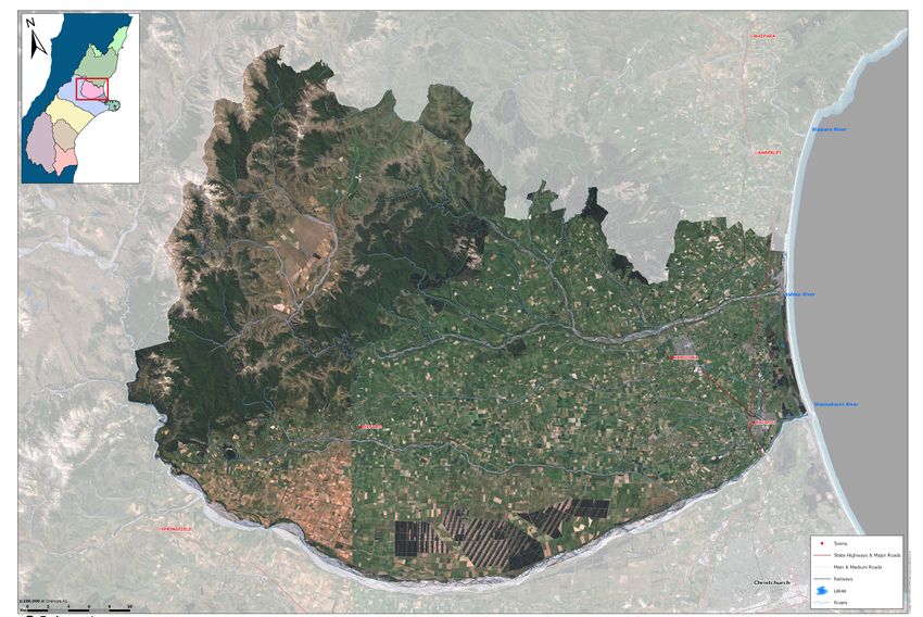
Waimakariri Zone Committee
  The Waimakariri Zone Committee is a joint committee of
  the Waimakariri District Council (ADC) and Environment
  Canterbury. The Committee are “local” people planning
  locally - the members are:
  Murray Lang
  Bill Wilson
  Claire McKay
  Kevin Felstead
  Rex Williams
  Clare Williams
  Terrianna Smith
  Grant Edge
  Bryan Sulzberger
  Darren Mann

  With support from:
  Mary Sparrow – Waimakariri District Council
  Nic Newman – Environment Canterbury

  (See http://ecan.govt.nz/get-involved/canterburywater/
  committees/waimakariri/Pages/membership.aspx for
  background information on committee members)

Mō tātou, ā, mō kā uri ā muri ake nei
  For us and our children after us
EXECUTIVE SUMMARY

      This Zone Implementation Programme has been produced under the Canterbury Water Management Strategy (CWMS)
      and is a non-statutory document. It has been prepared by the Waimakariri Zone Committee through a collaborative
      process. It is a collection of integrated actions and tactics to give effect to the CWMS in the Waimakariri Zone and it is
      a living document.

      The main features of this implementation programme are:

         •     A lowland waterways programme using a multipronged approach to improve waterway health

         •     The protection of coastal and foothill wetland biodiversity

         •     An integrated approach to managing the Ashley/Rakahuri River

         •     An education and extension programme for good water and nutrient management practice

         •     The role of water storage in providing irrigation reliability and improved river flows

      Abbreviations Used
         CWMS               Canterbury Water Management Strategy
         GWAZ               Groundwater Allocation Zone
         LSR                Land Surface Recharge
         ZIP                Zone Implementation Programme
         NRRP               Natural Resources Regional Plan
         WRRP               Waimakariri River Regional Plan
         NPS                National Policy Statement

Waimakariri Zone Implementation Programme                                                                                          3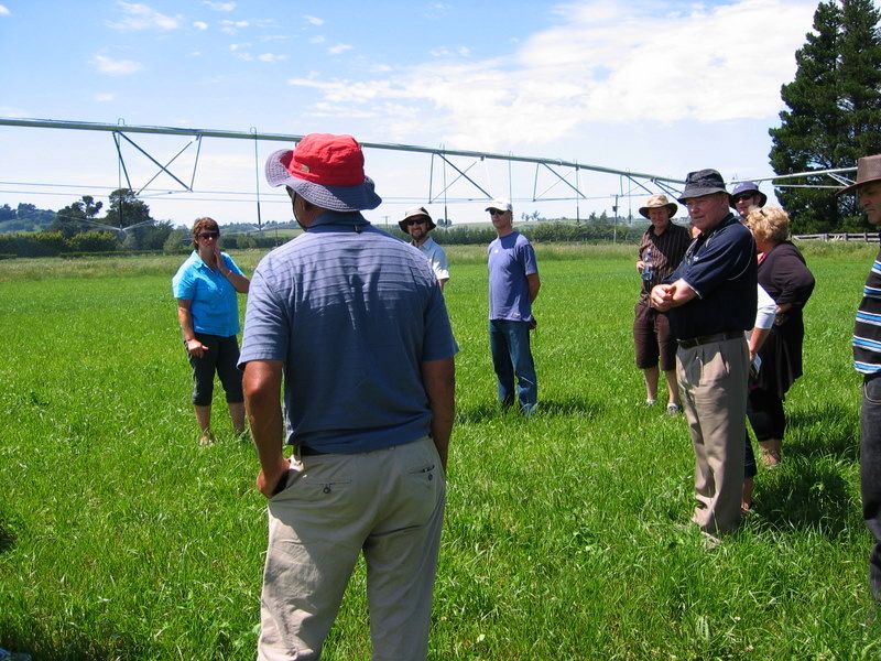
CANTERBURY WATER MANAGEMENT ZONES: WAIMAKARIRI
CONTENTS

            PART A: INTRODUCTION

            PART B: BACKGROUND

            •   B1.		 Overview of the Waimakariri Zone

            •   B2.		 Scope of the Programme

            •   B3.		 Zone Committee Process

            PART C: IMPLEMENTATION PROGRAMME

            •   C1.		 Key Principles

            •   C2.		 Priority Outcomes

            •   C3.		 Kaitiakitanga

            PART D: RECOMMENDATIONS

            •   D1.		 Lowland Waterways - Protection and Enhancement

            •   D2.		 Braided Rivers

            •   D3.		 Nutrient Management and water use efficiency

            •   D4.		 Water Supply

            •   D5.		 Biodiversity

            APPENDIX 1: THE CANTERBURY WATER MANAGEMENT STRATEGY AND THE
              		        WAIMAKARIRI ZONE COMMITTEE

            •   APPENDIX 1.1: CWMS Vision, Principles, and Targets

            •   APPENDIX 1.2: The Waiamakariri Zone Committee

            •   APPENDIX 1.3: Presentations and Reports to the Zone Committee

            APPENDIX 2: WAIMAKARIRI LOWLAND WATERWAYS

            APPENDIX 3: RECOMMENDED PRIORITY BIODIVERSITY AREAS

            APPENDIX 4: WAIMAKARIRI DISTRICT WATER RACES

            APPENDIX 5: GROUNDWATER ZONES

Waimakariri Zone Implementation Programme                                       5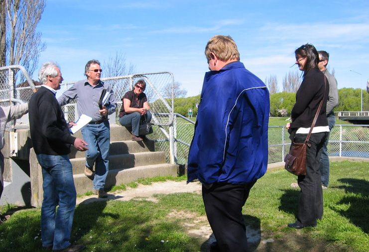
PART A: INTRODUCTION

The Land & Water Forum’s report on NZ’s current issues       resources within an environmentally sustainable
with water and its management, “A Fresh Look at Fresh        framework.” A set of ten targets provides the strategy
Water”, states “Water is causing disputes….............      with a sense of direction and balance, and ensures that
about Water Conservation Orders, infrastructure              all aspects of the solution are advanced in parallel.
development, intensification of farming, discharges          Achieving continued economic production and
from cities and towns, who should be involved in             environmental quality are key to the strategy.
management, who should pay for it, the role of
                                                             The CWMS establishes 10 Zone Committees, loosely
iwi….................New Zealanders have spent a great
                                                             defined by catchments, as the mechanism for
deal of time fighting one another politically, at hearings
                                                             consultation, assessment and decision making. Each
and in Courts, often with sub optimal outcomes.” The
                                                             Zone Committee is required to develop a detailed
Forum was established in the belief that stakeholders
                                                             implementation programme and is expected to
needed to engage directly with each other if we were to
                                                             work closely with the local community. The Zone
find a way forward.
                                                             Implementation Programme that results will be a “best
The Canterbury Water Management Strategy (CWMS)              endeavours” a “guidance document” a “best practice
has been developed since 2005 as collaboration               plan” for various sectors of the community who affect
between Canterbury’s 10 territorial authorities and the      or are affected by water issues. Zone Implementation
Canterbury Regional Council. The desired outcome             Programmes are not statutory documents, however
of the strategy is “To enable present and future             there is a very clear pathway, expectation and
generations to gain the greatest social, economic,           commitment for the programmes to be implemented,
recreational and cultural benefits from our water            resourced and given effect to.

PART B: BACKGROUND

B1. OVERVIEW OF THE WAIMAKARIRI ZONE

The Waimakariri Zone is characterised by the large alpine Waimakariri River, the hill-fed Ashley/Rakahuri River and
its tributaries and estuary, the Ashley Waimakariri Plain and the ground water zones (Ashley, Eyre, Cust, Loburn),
and a network of spring fed streams and lagoons in the coastal zone. Much of the land to the east of Rangiora is
reclaimed swamp, which is still subject to poor drainage and occasional flooding. The north-western portion of
the district is hill and high country. These hills, including Mt Oxford, Mt Richardson, and Mt Thomas dominate the
district’s western landscape.

Ashley / Rakahuri River                                      connection to the river, with a combined abstraction
                                                             rate of 991 L/s. There are also 46 groundwater permits
The Ashley/Rakahuri River has its headwaters in the          with a moderate or low degree of hydraulic connection,
Puketeraki range and receives the majority of its runoff     with a combined stream depletion rate of another
from these foothills. The average annual rainfall here       190L/s. These consents include urban, industrial,
is in the order of 1200mm. Below the gorge the river         and irrigation takes. A major investigation into the
losses water to the gravels as it flows across the plains    groundwater and surface water resources in the Zone
but gains flow from its tributaries. The greatest loss       will complete in July 2012. Climate change projections
of water occurs below the confluence with the Okuku          indicate reductions in average summer flows and an
River, where 2-3 m3/s are lost to the gravels. A large       increase in the frequency of extremes such as droughts
proportion of this loss feeds the springs and rivers to      and floods, it is also likely that irrigation demand could
the south e.g. The Cam/Ruataniwha River. The losses          increase. The combination of these effects could place
lead to the river having discontinuous flow and dry          more pressure on the river’s ecology.
reaches when the flow at the gorge is somewhere below
                                                             The Ashley/Rakahuri River features high quality
2.5-3.0 m3/s. The river will naturally be below 2.5m3/s
                                                             ecosystems from the gorge and above, although there
at the gorge flow recorder for, on average, 10% of the
                                                             is evidence of new algal growth in the upper braided
time, illustrating that in most summers the river would
                                                             reaches. Toxic algal outbreaks have been in evidence
have discontinuous flow and dry reaches. One area of
                                                             since 2007 in the middle reaches of the river. The
uncertainty is the effect that groundwater takes have
                                                             braided sections of the river provide breeding grounds
on groundwater levels and the losses from the Ashley
                                                             for the rare and endangered riverbed nesting species
River. There are 14 surface water permits and three
                                                             including wrybill, black-fronted tern and black-billed
ground water takes with a high degree of hydraulic
                                                             gulls. The Ashley/Saltwater Estuary is a feeding and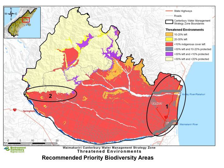
resting zone for the riverbed nesting birds, and is also swamp. Initial efforts to drain this wetland saw the
host to over 90 recorded species, including the bar- cutting of a major drain which diverted Eyre River water
tailed godwit. directly into the North Branch of the Waimakariri River.
As part of the major river works completed in the 1930s
For Ngāi Tahu, theAshley/ Rakahuri was the food basket
to control flooding the Eyre River was diverted directly
of Kaiapoi Pa, and continues to be of high cultural
into the Waimakariri River.
significance and highly used by Tangata Whenua today.
For much of the year the Eyre River has little water
Waimakariri River flowing above ground, but when in high flood it carries
substantial volumes of water and can do substantial
The Waimakariri River was significant as both a major
damage to its stop banks and the approaches to bridges
source of mahinga kai as well as traditionally providing
across that cross the River. Despite the absence of
several trails to the West Coast, including access to the
a surface water flow for long periods, seepage from
mahinga kai resources of the high country lakes. The
the Eyre River makes significant contribution to the
Waimakariri River connects the Southern Alps to the
groundwater of the Waimakariri/Ashley plain.
Pacific Ocean, while running through the Canterbury
Plains. Its headwaters are the main divide of the In a desire to reduce the wide fluctuation of
Southern Alps and it has a 2,500 square kilometre groundwater in this area the Canterbury Regional
catchment in the mountains. Approximately 90% of Council issued a consent for Waimakariri Irrigation
the water reaching its mouth originates from above Limited to undertake augmentation trials involving
the gorge. The lower reaches of the river have been releasing Waimakariri River water into the Eyre River.
straightened and has extensive flood protection works. These trials were conducted in September 2005,
The river loses to groundwater at Christchurch / West with neighbouring wells being monitored to ascertain
Melton and gains surface water from the Kaiapoi area. whether the release of water into the Eyre River
Monitoring indicates that the river gains groundwater would lead to an increase in the groundwater levels.
from the Waimakariri District above the SH1 bridge. Although the trials confirmed that water released into
Climate change projections indicate that there will be the Eyre River would contribute to groundwater levels,
less snowpack in the upper catchment and more winter augmentation of the Eyre River was not proceeded with.
and early spring rainfall (including extreme events).
The Cust River rises in the foothills to the north of
The Waimakariri River is regionally recognised as Oxford, and originally flowed into the Rangiora-Ohoka
an outstanding natural landscape feature. It is also swamp at Fernside to the west of Rangiora. In the
considered to be an exceptional recreation resource 1860s moves were made to drain the Rangiora-Ohoka
and is the most paddled, most fished, and most jet swamp with the cutting of a main drain, and a series of
boated river in New Zealand. The Waimakariri River side drains which joined the Main Drain. Today the Cust
Regional Park provides for recreation activities such River is linked to the Main Drain by a channel known as
as: jet boating, mountain biking, kayaking, trail biking, the No 1 Drain. As with the Eyre River, parts of the Cust
swimming, and fishing. River bed carry no water for periods during the late
summer and early autumn. Despite this, the Main Drain
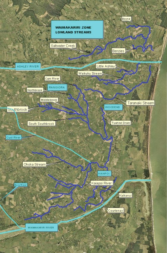
Lowland Streams and Coastal Lagoons carries water throughout the year because its flow is
The lowlands of the Zone are made up of spring augmented by water from springs in the base of the No
fed streams, coastal lagoons and estuaries. This 1 Drain and from the side drains some of which are also
area includes the significant Tūtaepatu lagoon, the spring fed. The Cust Main Drain system joins the Kaiapoi
nearby Kaiapoi pā, and associated wetland areas and River (formally the North Branch of the Waimakariri
vegetation remnants. Secondly the lowland waterways, River) close to the confluence of the Kaiapoi River
including: the Cam/Ruataniwha River, the Kaiapoi and Ohoka Stream, one of the area’s more significant
River (Silverstream),Waikuku Stream, Little Ashley, lowland streams, and west of the point at which the
Taranaki Creek, Saltwater Creek, Courtenay stream and Cam River joins the Kaiapoi River.
Ohoka Stream. These spring-fed streams are important There are some consented surface water takes from the
for koura, longfin and shortfin eels, lamprey and Cust Main Drain system, and there is a minimum flow
invertebrates. Thirdly the mouth of the Ashley/Rakahuri regime in place for the Cust River, and also for the Cust
and Waimakariri Rivers. The Ashley/Rakahuri River Main Drain. The flows in the Main Drain are monitored
mouth has been described as one of the most important at Threlkelds Road, and are usually in the vicinity of 1.5
bird habitats of the east coast of the South Island and it to 3.0 cumecs, although recordings in excess of 30.0
is a very important resource for whitebait and estuarine cumecs are recorded on a few occasions each year.
fish species. Environment Canterbury’s records show that unlike
many Canterbury Rivers the Cust Main Drain system
The Eyre and Cust Rivers showed an increase of 5 percent in mean flows between
The Eyre River has its headwaters in the Puketeraki mid-2001 and 2006 and the mean flow full record (for
Ranges to the south-west of Oxford and is part of the as long as this record was available).
Waimakariri River system. Originally water from the The lower reaches of the Cust Main Drain system are
Eyre River flowed into an inland wetland, which became valued as a spawning area for trout, and are fished
known in early European times as the Ohoka-Rangiora frequently. The banks of the Main Drain are also an
Waimakariri Zone Implementation Programme 7
important recreation area, as they provide space for           Pegasus 10-12,000. The Mandeville area is also
people from the neighbouring urban areas to walk               expected to see a significant increase in its population,
and exercise their dogs close to running water. Also,          from the current 300 households, over the next few
in view of the proximity of the Cust River to centres of       years. Recent Plan changes and the Council’s 2010 Rural
population in the District, it is one of the priority rivers   Residental Zone Strategy will see approximately 600
for the taking of Esplanade Reserves or Strips upon            households living in the Mandeville area in the future.
subdivision of adjacent land in the Waimakariri
District Plan.                                                 Economy
                                                               Some 11% of the district’s labour force is involved with
Ngāi Tahu                                                      agricultural, forestry and fishing. There has recently
Tangata Whenua (those with traditional status, rights          been a substantial increase in the number of people
and responsibilities in their traditional territories)         living in the district’s rural areas and many new
in the zone are Te Rūnanga o Ngāi Tūāhuriri and Te             medium-small holdings have been created. These
Taumutu Rūnanga. These Rūnanga have kaitiakitanga              holdings, together with the district’s rural residential
responsibilities. Kaitiakitanga is the concept of              zones, provide new opportunities for people to live
stewardship and the expression of kaitiakitanga is             in the district’s rural areas. The district has few major
through actions to protect natural resources, including        industries. A large fibre-board plant at Sefton draws on
through the involvement of Rūnanga in the decision             local wood resources. The other industries are mainly
making and management of those resources. Water                small-scale service and processing enterprises, some of
is central to the Ngāi Tahu resource management                which also use local wood resources.
philosophy ‘ki uta ki tai’ – from the mountains to the
sea. For Ngāi Tahu this requires a holistic view of the        Irrigation
world and integration and co-operation between
                                                               A large portion of the Waimakariri Zone is fertile flat
agencies, legislation and management frameworks.
                                                               land, or highly productive rolling downs.
For Ngāi Tahu, water is a taonga left by the ancestors
                                                               Irrigation in the Zone is based on individual wells
to provide and sustain life. All the waterways and their
                                                               predominantly in the lower reaches of the Zone, and 3
associated tributaries, wetlands and springs in the
                                                               surface water irrigation schemes. The dominant scheme
zone are considered significant resources, of cultural,
                                                               is Waimakariri Irrigation Limited which has provided
spiritual and historical importance to Ngāi Tahu.
                                                               irrigation water since 2000, via a network of channels
The ability to gather and share food is a cornerstone          based on the District’s stockwater races. The command
of Ngāi Tahu society, tradition, and mana and is reliant       area is 40,000ha, of which approximately 18,000 is
on water that is fit for human consumption and able            irrigated. 10.5 cumecs is taken from the Waimakariri
to support mahinga kai species as well as a healthy            River under the Waimakariri River Regional Plan and
ecosystem. Important areas for food gathering in               provides low, less than80%, reliability for irrigation.
the zone have been the coastal wetlands, the Ashley/
Rakahuri River and estuary, and spring fed streams such        Drainage
as the Cam/Ruataniwha. Prior to direct discharges to the       The Waimakariri District Council is responsible for
Waimakariri, it too was an important mahinga kai area.         maintenance of the public rural and urban drainage
More generally, the following areas are of significance to     systems as well as for some natural waterways.
Ngāi Tahu due to the cultural values found there:              The rural systems comprises of natural and modified
• Hapua/lagoons                                                drains, culverts and control structures (e.g. weirs).
• River mouths                                                 The urban drainage system comprises of sumps, pipes,
                                                               pump stations, swales, treatment basins and ponds.
• ara tawhito (trails)
                                                               The natural waterways include numerous small spring
• mahinga kai and places with indigenous biodiversity          fed waterways, as well as parts of the Cust Main Drain,
• wāhi taonga and wāhi tapu (places that hold respect          Cam River / Ruataniwha and the Kaiapoi River.
   and sacred sites and places)
• repo raupō/wetlands and waipuna/springs                      The Council aims to maintain these systems in such
• nohoanga/seasonal occupation sites                           a way that they have minimal adverse impact on the
                                                               natural environment.1
  • riparian areas

Population                                                     Areas of Responsibility
                                                               Environment Canterbury is responsible for water quality
As at June 30 2011 the Waimakariri Zone had an
                                                               and consented abstraction. It is also responsible for
estimated resident population of 48,600. Approximately
                                                               ensuring that any stopbank or river protection works
60% of these people live in the Zone’s five main
                                                               are maintained, as well as carrying out maintenance
urban areas. A further 20% live in the Zone’s smaller
                                                               on most of the larger waterways. The Waimakariri
settlements. Projections indicate that by 2022 the
                                                               District Council has responsibility for land drains and
population will be in the vicinity of 59,500 with 65%
living in the main urban areas. By then Rangiora’s
population will be approaching 16,000 and Woodend/
urban rainfall collection. Only those drains that are area is significantly recharged by losses from the Ashley
designated Public Drains are maintained by the Council, River.
other drains are the responsibility of the property
The groundwater resources of the Waimakariri zone are
owner. There are also areas of joint responsibility:
currently being investigated by Environment Canterbury.
the Cust from the Oxford foothills to just west of the
It is expected that as a result of the investigation
Cust township is a District Council responsibility for
there will be enough information available to start the
maintenance, but beyond that point to Kaiapoi it is the
planning process to alter the GWAZ boundaries and
responsibility ofEnvironment Canterbury. The Cam River
allocation limits.
(Ruataniwha) is maintained by the District Council from
its source near Woodend Road to Bramleys Road and
Drinking Water
by Environment Canterburyl from Bramleys Road to the
Kaiapoi River. Drinking water quality in the Waimakariri Zone is
generally of a very high quality. 17 water supply
Groundwater2 schemes are operated by the district council,
including 8 on-demand urban and 9 restricted rural.
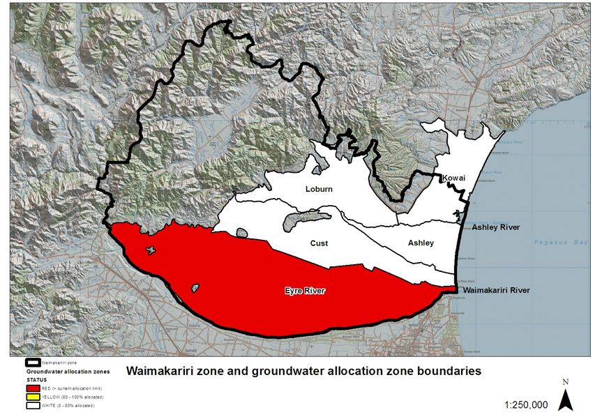
There a four groundwater Zones in the Waimakariri However, throughout the coastal area of the zone,
Water Management Zone: Ashley, Cust, Eyre, poor groundwater appears in some places of old
and Loburn with a fifth, the Kowai, straddling the swamp. This is characterised by iron, manganese, and
Waimakariri and Hurunui Zones. hydrogen sulphur odour and is a result of the decay
of organic materials forming peat in the sediment.
The Ashley Groundwater Allocation Zone (GWAZ) is
Tuahiwi township has a significant drinking water quality
significantly recharged by losses from the Ashley River.
problem. The township is not on a council drinking
Typically in the Ashley GWAZ wells are shallow and are
water scheme.
high yielding. There are increasing numbers of flowing
artesian wells approaching the coast. In the Cust GWAZ
utilisation of the groundwater resource in the Zone is
Investigations
limited in many areas due to low yields. Well yields The Ashley/Waimakariri surface water and groundwater
and artesian conditions increase towards the coast. investigation is a major project to provide a much
The Eyre GWAZ is currently termed as a “red zone” improved understanding of the water balance and
or effectively fully allocated under the current limit. surface water and groundwater interaction in the
Historically groundwater utilisation in the Eyre GWAZ Zone. The conclusions and recommendations from this
was limited to shallow wells primarily recharged by investigation are due to be published in a technical
land surface recharge (LSR) and Eyre River intermittent report by July 2012.
recharge which in dry years can become unreliable.
The development of the Waimakariri Irrigation Limited Regulatory Framework
(WIL) scheme since 1999 has led to increased recharge The Natural Resources Regional Plan (NRRP) is the
(a combination of race leakage and additional LSR) and major planning document within the Waimakariri
increased groundwater reliability. Most wells in the Zone. The NRRP became operative on 11 June 2011 and
Loburn GWAZ are shallow and typically have low yields. there are a number of chapters in the operative plan
This is reflected in the low utilisation of the groundwater provide statutory directions to manage natural and
resource in this zone (2% of the current allocation limit). physical resources within the zone. The Waimakariri
In the Kowai GWAZ groundwater utilisation is limited River Regional Plan (WRRP) has been operative since
on the downlands due to low well yields in part caused 2004 and it provides specific statutory provisions to
by limited rainfall infiltration through the loess derived manage water quality, water quantity (surface water
soils. However the well yields in the flatter coastal and hydraulically connected groundwater) and land use
Saltwater Creek area are higher and as a consequence issues within the Waimakariri catchment. In the absence
more development has occurred. The Saltwater Creek of any statutory provisions in the WRRP, the NRRP
provisions can be used to manage natural and physical
resources.
B2. SCOPE OF THE ZONE IMPLEMENTATION PROGRAMME
This Waimakariri Zone Implementation Programme (ZIP) is intended to direct the implementation of the Canterbury
Water Management Strategy (CWMS) in the Waimakariri Water Management Zone. The role of the Zone Committee
is to develop the actions, strategies and tactics that form the recommendations for integrated water management.
These recommendations are not designed to be read in isolation from each other. For more information on the CWMS,
including principles and targets, see Appendix 1.
Waimakariri Zone Implementation Programme 9The implementation programme is seen as a rolling ten ZIP carries the weight of the wide commitment to the
year programme. This is the first version and contains CWMS, of Councils, Industry, Rūnanga, Agencies and the
recommendations principally for actions in the next community. This ZIP contains 46 recommendations for
three years, but with a long-term horizon. The ZIP is a Environment Canterbury, Waimakariri District Council,
living document and the Zone Committee will review and other agencies. Work is already underway on some
progress against it and update it as required. of the recommendations to Environment Canterbury and
the implications for regional council work programmes
The Zone Implementation Programme is not a statutory
will form part of the Long Term Plan discussions.
plan under the Resource Management Act. However
the CWMS is referred to in several areas of the draft The geographic area covered is that of the Waimakariri
Regional Policy Statement and in the Environment District. Encompassing: the entire catchment of the
Canterbury Temporary Commissioners and Improved Ashley/Rakahuri River, the catchment of Ashley/
Water Management Act 2010. Various agencies will Saltwater Creek Estuary, the Ashley/Waimakariri
respond to the recommendations herein, with both Plain, the foothills of Mt Grey, Mt Thomas, and Mt
non-statutory and potentially statutory actions. The Oxford, the coastal lowlands from the Waimakariri
Zone Committee does not have the power to commit River to Saltwater Creek, and a shared boundary of the
any Council to any path nor expenditure. However the Waimakariri River below the gorge.
B3. ZONE COMMITTEE PROCESS
The Zone Committee operates under the collaborative At a workshop the Committee identified priority
approach of the Canterbury Water Management Strategy outcomes for implementing the CWMS in the zone and
and consensual decision making has been sought on all held community meetings to discuss these. These
committee decisions. This ZIP aims to address all the included safe and secure drinking water for the Zone,
CWMS targets together, according to the principle of protection of coastal lagoons and foothills wetlands,
parallel development. enhancement of lowland streams and improved
The Waimakariri Zone Committee is made up of 6 mahinga kai, greater water use nutrient efficiency,
community members who represent a wide range of 95% reliability for irrigation water, protection of
interests, a member each from Ngāi Tūāhuriri Rūnanga the Waimakariri River as a recreation resource and
and Taumutu Rūnanga, a Waimakariri District Councillor, improved ecosystem health of the Ashley/Rakahuri
and an Environment Canterbury Commissioner. The River. Feedback from the community indicated the need
members of the Zone Committee are appointed for their for nutrient management science and communication
ability to work collaboratively and to be able to balance of tools to support best practice, support for water
competing interests. For details of the Zone Committee quality and biodiversity outcomes, strong support for
membership – see Appendix II. water storage as a way to meet multiple outcomes, and
highlighted to the committee the high value placed
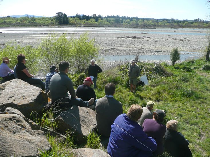
The Zone Committee have had eleven meetings and on the Ashley gorge and the Ashley/Rakahuri River.
workshops since orientation in September 2010. They The Committee then identified integrated pathways
have undertaken field trips which have included: the to address the agreed outcomes and formed working
Ashley/Rakahuri River, lowland streams, Waimakariri groups to address these. These working groups were:
Irrigation Limited, a dairy farm, the Loburn Irrigation Nutrient Management and Water Use Efficiency, the
Company, horticultural enterprises, Ashley Gorge Ashley/Rakahuri River, Water Supply, and Lowlands and
and the Lees Valley. The committee have engaged Biodiversity. These working groups developed details
directly with Ashley/Rakahuri Rivercare group, Ohoka and reported back recommendations to the full Zone
Stream care group, Waikuku Water Management Committee. The Zone Committee welcome ongoing
Group, Waimakariri Irrigation ltd, Irrigation NZ, MAF, community engagement and committee meetings
Loburn Irrigation Company, Canterbury District Health are open to community participation.
Board, Lees Valley and Ashley Gorge landowners. The
Committee have received briefings on: hydrology in
the zone, water allocation in the zone, water quality,
the role of small holdings, drinking water, drainage
management, irrigation, strategic storage options,
Tangata Whenua cultural values, indigenous vegetation
and biodiversity, regional and district planning, and
future climate projections.PART C: IMPLEMENTATION PROGRAMME
C1. KEY PRINCIPLES
• A ‘whole of waterway’ approach is taken to • The pathways and recommendations in this
integrate management from the mountains to ZIP represent an integrated approach to water
the sea – Ki Uta Ki Tai. The Zone Committee wish management and they are not to be considered
to see activities integrated across agencies and in isolation. The Zone Committee recognise the
groups working together in an outcome based need for an integrated approach to water quality,
approach. quantity, and land management.
• KaitiakiKaitiakitanga is integrated into each • The collaborative approach that has been used
pathway with actions to address water quality in the development of the CWMS and by the zone
and quantity concerns and provisions for committee in developing this Implementation
improved customary use and the involvement Programme must be carried through to the
of Rūnanga in water management being weaved implementation of the recommendations.
through this document.
C2. PRIORITY OUTCOMES
• Lowland streams water quality and water • The Biodiversity of coastal lagoons and
quantity supports mahinga kai gathering and a foothills wetlands are protected with improved
diversity of aquatic life biodiversity on the plains
• The Ashley /Rakahuri River is safe for contact • Highly Reliable Irrigation water, to a target of
recreation, has improved river habitat, improved 95%, is available in the Zone
fish passage, improved customary use, and flows
• Optimal Water and Nutrient management is
that support natural coastal processes
common practice
• The Waimakariri River flows support in-stream
• There is improved Contribution to the Regional
ecosystems and coastal processes and the
Economy from the Zone
river is protected as an outstanding recreation
resource
• The zone has safe and reliable Drinking Water,
preferably from secure sources, and the Tuahiwi
community has a high quality water supply
Waimakariri Zone Implementation Programme 11C3. KAITIAKITANGA
Kaitiakitanga is the traditional Māori philosophy of resource management. Some of its key principles are:
a. Whakapapa (Genealogies & Generations) – All e) Redesigning the flood gates on lowland streams
elements of nature are related in space and where fish passage is impeded. Without being
time and therefore what happens ‘upstream’ will able to pass upstream, most native fish cannot
effect what happens ‘downstream’; fulfil their lifecycle
b. Ki uta, ki tai (From Mountains to Sea) – Resource f) Keeping stock out of waterways. Stock, in
management based on ‘catchments’ given that particular cattle and deer, damage riparian
what happens ‘upstream’ effects what happens margins, adding sediment and nutrients to the
‘downstream’; water, which has a negative impact on native
flora and fauna
c. Mauri (life, health & vitality) – Mauri is the
traditional measure of physical, spiritual and/or g) Ensuring appropriate drain management
emotional wellbeing of people and places. clearance methods, so that native biodiversity is
protected and not destroyed in the process.
d. Wakawaka (Hunting & Gathering Grounds)
– Traditional rights to access and use key As h) Protecting springs from inappropriate use and
Kaitiaki, particular issues of concern in the zone degradation. Lowland springs are of high cultural
that the Rūnanga wish to see addressed are: and spiritual significance to Tangata Whenua
e. resources (including water) were collectively i) Protecting and enhancing wetlands. There are
managed and premised on one’s ability to uphold few wetlands left in the zone. They provide
any associated responsibilities3. habitat for a wide range of mahinga kai and other
native species.
f. Utu (Balance, Reciprocity) – Failure to uphold
one’s responsibilities could result in the Tangata Whenua, as Kaitiaki, want these concerns
associated rights being removed or restricted. addressed, to ensure healthy ecosystems for the
community and for future generations. They want the
The principles of kaitiakitanga are best provided
mauri (life-force) of rivers, streams, springs, wetlands
for by weaving them throughout the ZIP and through
and lagoons restored and protected. They also recognise
implementation of the ZIP – not by relegating them into
and support the need for sustainable regional economic
a single, stand-alone section.
development, and believe that this is fundamentally
a) Finding solutions to the poor drinking water dependent on sustaining healthy waterways. They hope
quality at Tuahiwi township. Residents of that Ngāi Tahu Property will be able to lead the way in the
Tuahiwi have observed that their waterquality Zone in respect to best practice in their proposed dairy
has deteriorated, while most of the zone has conversion.
excellent drinking water.
b) Returning mahinga kai resources to lowland
streams and ensuring water quality is suitable for
food gathering.
c) Ensuring there is sufficient water in the Ashley/
Rakahuri River to enable fish passage throughout
the river, ki uta ki tai.
d) Having places where the families of the Rūnanga
and wider community can go to swim and
fish. There are issues with water quality and
quantity in the Ashley/Rakahuri river and lowland
streams.Tangata Whenua Rights & Interests Commentary
in Water It is worth noting that, notwithstanding the unresolved
The Zone Committee notes that the issue of indigenous nature of their rights to freshwater, Ngāi Tahu have
rights to fresh water lies beyond the purview of the made it very clear that economic development is
CWMS and is not a matter that the Committee can vital for the region and for the nation, and Ngāi
resolve. Indeed, indigenous rights to fresh water in Tahu representatives on the Committee have fully
Canterbury can only be resolved by Ngāi Tahu and participated in discussions around how best to use
Crown representatives as it relates to agreements water for regional economic benefit while protecting,
reached by their predecessors under the Treaty of maintaining or enhancing their wider social,
Waitangi (1840) and the Sale & Purchase Agreement for environmental and cultural values in waterThey have
Canterbury (1848). That said, the Committee recognises been very clear that sustainable economic development
the following: is fundamentally dependent on sustaining healthy
waterways. Poor water, poor economy! No water, no
a) That the relationship between Tangata Whenua
economy!
and freshwater is longstanding;
Water quality should therefore be the paramount
b) That Tangata Whenua’s relationship with water is
determinant governing all land and water use and
fundamental to their culture;
development, ensuring that land and water users share
c) That water per se is valued as a taonga of relative responsibility to protect, maintain or enhance
paramount importance; and environmental values as a matter of first order priority
so that the water can continue to uphold economic,
d) That the obligations to protect and enhance the
social and cultural endeavour for generations to come.
mauri of water are inter-generational and must
apply to all those who benefit from the use of Ultimately, Ngāi Tahu seek outcomes from water that:
water.
a) Sustain the physical and metaphysical health
and well-being of waterways as a matter of first
principle;
b) Ensure the continuation of customary in-stream
values and uses; and
c) Satisfy development aspirations.
Waimakariri Zone Implementation Programme 13PART D: RECOMMENDATIONS
The following recommendations are the heart of the Implementation Programme and represent intertwined pathways
to integrated water management and are not to be considered in isolation. These are ordered by the principal types of
waterways in the zone and then by cross cutting theme. The ‘aspect column’ is a sub-heading of the main chapter heading.
D1. LOWLAND WATERWAYS - PROTECTION AND ENHANCEMENT
Aspect Recommendation Responsibility Timetable CWMS Target
1.1 Lowland Streams A lowlands waterways programme is Environment From 2012 Ecosystem
Enhancement developed and implemented using a Canterbury, Health and
multi –pronged approach to encourage Waimakariri Biodiversity
and assist property owners adopt best District Council,
practice for stream management Rūnanga, Zone Kaitiakitanga
Committee
Recreation
1.2 Lowland Streams A programme of monitoring: water Environment From 2012 Ecosystem
Monitoring quality, aquatic biodiversity, and cultural Canterbury, Health and
health is established to measure progress Waimakariri Biodiversity
Informs Nutrient and guide future work District Council,
Management Rūnanga, Zone Kaitiakitanga
Recommendations Committee
1.3 Drainage Support the balanced approach that Waimakariri ongoing Ecosystem
Management the Waimakariri District Council takes District Council Health and
to drainage management in the zone, Biodiversity
including working with Ngāi Tūāhuriri
Rūnanga Kaitiakitanga
1.4 Improved waterway Catchment Management Plans are Environment From 2012 Ecosystem
management developed for all waterways in the zone, Canterbury, Health and
which will include the Kaiapoi River Waimakariri Biodiversity
network District Council
Kaitiakitanga
Recreation
1.5 Improved Fish Existing floodgates on lowland waterways Environment 2013 Kaitiakitanga
Passage are modified where required to allow Canterbury
fish passage and any new structures Recreation
on lowland waterways must allow fish
passage
1.6 Lowland Streams A Global Consent for minor works in Environment 2012 Ecosystem
Enhancement waterways, and criteria for its use, is Canterbury, Health and
developedand held by the Waimakariri Waimakariri Biodiversity
District Council District Council
1.7 Improved Support Waimakariri District Council Waimakariri Ongoing Ecosystem
Stockwater race enforcing their Stockwater Race Bylaw District Council, Health and
management 2007 with particular regard to cattle and Waimakariri Biodiversity
on-land deer in water way1 Irrigation Limited1.8 Environment Ongoing Ecosystem
Support Environment Canterbury
Improved waterway Canterbury Health and
enforcing the NNRP rules relating to stock
management Biodiversity
exclusion from waterways2
1.9 Waimakariri 2012 Ecosystem
Develop and deliver ‘Current Best
Improved waterway District Council Health and
Practice’ guidelines for contractors who
management Biodiversity
carry out waterway cleaning
2.0 Waimakariri 2012 Ecosystem
Develop and deliver ‘Current Best
Improved drainage District Council Health and
Practice’ guidelines on rural drain
management Biodiversity
management, for private landowners
Rationale An Implementation Group would be established to
oversee and co-ordinate future works on all the lowland
Lowland (spring -fed) Streams in the Zone are highly streams in the district. This would consist of Zone
valued by the community4. Many are in varying states Committee Representatives, Environment Canterbury
of degradation. Progress has been made on addressing representatives (Co-coordinator/Biodiversity Officer),
issues associated with these waterways through DOC, Waimakariri District council representative.
working with landowners and the Waimakariri District (Drainage Asset Manager/representative and Cam River
Council, the Environment Canterbury “Living Streams” Restoration Fund representative), and a Ngāi Tūāhuriri
programme, and through specific actions such as Rūnanga representative
the Ocean Outfall for treated sewage, Northbrook
Stormwater ponds, and the District Council approach to Other actions to improve lowland waterway health are
drainage management. found in the nutrient management recommendations,
including the setting of nutrient limits for waterways.
The Zone Committee recommends a Lowlands Stream
Programme to reduce fine sediment inputs nutrient Floodgates on lowland waterways have not been
loadings, lowering of faecal coliforms to contact designed to permit fish passage, and further work is
recreation standards, increased biodiversity by riparian needed to redesign these for this purpose. The zone
planting of native plants and the protection of spring committee and Ngāi Tūāhuriri Rūnanga wish to see
heads. integrated waterway management based on outcomes
under the CWMS, and the passage of fish species and
The programme will take a multi faceted approach harvest are fundamental components of kaitiakitanga.
including:
a. Information and education as to the recommended There is an issue with the ability to carry out minor
management works of a restorative nature in waterways and
b. The statutory requirements with regard to stock the disincentive provided by the resource consent
access to waterways are publicized and given application cost and process. It is proposed that a
effect to global consent be developed for such works (including
c. Riparian management, i.e. fencing and planting works to enhance braided bird habitat) and be held by
is encouraged by showing the techniques required. the District Council, and that groups and individuals
The use of demonstration sites is recommended, who wish to carry out works supported by this
with public planting days to enable information implementation programme apply to the district council
transfer to work from their consent, with appropriate safeguards
d. Plant species, planting techniques, site and advice on best practice.
preparation and post planting management Waimakariri District Council’s approach to drainage
information needs are freely available. management is endorsed by the Zone Committee.
e. Sources of funding and available assistance are The Council programmes it’s drain clearing work during
publicized the months from October to March inclusive and uses
f. The function, variety and value of wetlands is low impact methods to minimise the effect on aquatic
demonstrated life while still allowing the drains to be effectively
cleaned to carry out their primary function. The Council
also works with the local Rūnanga to ensure that any fish
that are removed from drains in the cleaning process,
are returned to the waterway. The Council encourage
planting alongside drains where it can provide habitat
and shade, which in turn reduces the frequency
that drains need to be cleaned.
Waimakariri Zone Implementation Programme 15Waimakariri District Council operates a water race The committee also supports the enforcement of
network supplying stockwater to farmers on land the NRRP and the rules around stock exclusion from
between the Ashley /Rakahuri and the Waimakariri waterways.From June 2012 the NRRP prohibits: dairy
Rivers5. The scheme consists of an open channel cattle or farmed pigs discharging or disturbing the bed
stockwater supply scheme, delivering to approximately of all rivers, lakes and wetlands and cattle, farmed pigs
42,500 hectares. The stockwater (and irrigation water and farmed deer discharging or disturbing the bed of
networks) are managed by Waimakariri Irrigation, identified spring fed streams, a river within 1 kilometre
under contract to the Council. The Zone Committee of a freshwater bathing site or community drinking
is concerned about the impacts heavy stock access water supply intake, a significant salmon spawning
to the stockwater races has on water quality that reach, or inanga (whitebait) spawning areas.
discharges to the above waterways, particularly with
The Zone Committee acknowledge that there is an area
regards E.Coli and Phosphorus. They recommend cattle,
of waterways which are not directly addressed under
deer, and pigs are excluded from stockwater races on
this Lowland Waterways section, nor the braided rivers
farm, via permanent or temporary fences, and support
section. These are the hill-fed waterways in the Zone
theenforcement of the Stockwater Race Bylaw that
such as the Cust, Eyre, Glentui, and Coopers Creek etc.
prohibits animals lingering in stockwater races.
These waterways are important and are valued by the
community. The committee has focused attention on
the Ashley/Rakahuri and the Lowland Waterways in this
first work, and will come to the above waterways in the
future.
D2. BRAIDED RIVERS
Aspect Recommendation Responsibility Timetable Target / Goal
2.1 Improved Ashley Integrate catchment management for the Environment From 2013 Natural
/ Rakahuri River river to include: flood and erosion control, Canterbury Character of
Management environment and biodiversity, customary braided rivers
use, and recreation
Recreation and
Amenity
Biodiversity
Kaitiakitanga
2.2 Improved Ashley Carry out investigations into options Environment 2012/2013 Natural
/ Rakahuri River for managing the river above the Okuku Canterbury, Character of
Management confluence, including a potential new DOC braided rivers
rating district or works program.
2.3 Woody weed Implement a willow and weed control Environment From 2012 Natural
control strategy on the Ashley /Rakahuri River Canterbury Character of
above the Okuku confluence braided rivers
2.4 Improved Investigate the installation of a permanent Environment 2012/2013 Ecosystem
Monitoring and flow recorder in the lower reaches of the Canterbury Health and
Investigations Ashley/Rakahuri River Biodiversity
Informs Nutrient Environmental
Management Limits
Recommendations
2.5 Improved Support the Ashley/Rakahuri Regional Park Environment 2014 Recreation and
recreational and consider the extension of the park Canterbury Amenity
opportunities above the Okuku confluence2.6 Protection of wāhi Undertake a COMAR3 study for the Ashley/ Rūnanga with 2012/2013 Kaitiakitanga
taonga and mahinga Rakahuri to identify flows and quality to ECAN support
kai enable protection of key sites and mahinga
kai resources
Informs Nutrient
Management
Recommendations
2.7 Improved fish Support is given to community groups and Fish and Game Ongoing Ecosystem
passage Rūnanga to assist fish salvage and passage Health and
from pools on drying reaches of the river. Biodiversity
Kaitiakitanga
Recreation and
Amenity
2.8 Improved support Support is given to rivercare and Environment Ongoing Ecosystem
for community streamcare groups protecting endangered Canterbury Health and
groups river nesting birds, and endangered fish Biodiversity
and plant species.
2.9 Improved river flow Any large water storage development Environment Ongoing Natural
under the CWMS in the zone provides to the Canterbury Character,
Informs Ashley/Rakahuri river: higher low flows, Processes and
Water Supply flow variability, flood flows, adequate ecological
Recommendations flushing flows, fish passage, support the health of
health of the estuary and hapua, and braided rivers
appropriate sediment transfer
Kaitiakitanga
2.10 Management of Support Waimakariri District Council’s Waimakariri 2012 Ecosystem
Recreation enforcement of its bylaw to control District Council Health and
recreational use of the Ashley/Rakahuri Biodiversity
Estuary
2.11 Waimakariri Industry, ongoing Recreation:
River Contact Christchurch City Increase in
Recreation Identify all industrial discharges to the Council, river bathing
Waimakariri River Environment sites suitable
Canterbury, for contact
Investigate and timetable alternative Waimakariri Zone recreation
options for the industrial discharges to Committee,
progressively cease discharge to the river, Christchurch Kaitiakitanga:
over time West Melton Zone Direct
Committee discharge of
point source
contaminants
2.12 Protection of Any new water storage development Environment Ongoing Recreation:
Recreation preserves the exceptional recreational Canterbury Maintain
Opportunities and resource and natural character of the the existing
Natural Character Waimakariri River diversity and
of the Waimakariri quality of
River water based
recreation
Informs sites,
Water Supply opportunities,
Recommendations and
experiences
Waimakariri Zone Implementation Programme 172.13 Waimakariri River Support the Waimakariri River Regional Environment Ongoing Recreation
Recreational Park Canterbury
Opportunities
2.14 Waimakariri River Support the Selwyn Waihora Zone Environment From 2011 Ecosystem
Biodiversity Committee protection of biodiversity in the Canterbury, Health and
Upper Waimakariri Selwyn Waihora Biodiversity
Zone Committee
2.15 Whole of Initiate a process to address the Environment 2012 Natural
Waimakariri River Waimakariri River within the CWMS, under Canterbury, Character,
the principle ‘Ki Uta Ki Tai’ Regional Processes and
Committee, ecological
Selwyn Waihora health of
Committee, braided rivers
Waimakariri Zone
Committee,
Christchurch West
Melton Committee
Rationale Tangata Whenua are also keen to collect information
that can more specifically answer questions around
The Ashley / Rakahuri River is currently rated and
ideal flows and water quality needed to protect their
managed for flood and erosion by ECan from the
values. A monitoring framework, called COMAR
Okuku river to the coast. This work includes channel
(Cultural Opportunity Mapping, Assessment and
clearing such as spaying and cutting exotic vegetation
Response) has been developed and will be used to
and directing and controlling commercial extraction
better inform the CWMS targets. The Ashley/Rakahuri
of shingle. This is funded 70% from a targeted rate,
River is the initial priority for COMAR in the zone.
15% from Works and Services rate, and 15% from
General rate. ECan are also implementing a Regional The Ashley/Rakahuri is home to a number of endangered
Park on the river up to the Okuku confluence. Above river bed nesting birds, in particular the wrybill, the
the Okuku confluence the river is not managed and black fronted tern, and the black billed gull. The Ashley
is characterised by exotic weed encroachment and Rakahuri Rivercare Group is working to protect the birds
significant erosion of productive land. Proposals for and their habitat, and the Zone Committee support
water storage in the Lees Valley highlight the need and their work. Also native and sports fish become stranded
opportunity for whole of river management. There is in pools in the river in summertime and there is the
the conceptual opportunity to manage the whole of opportunity to assist the community with fish salvage
the river for multiple values, including a Regional Park and transfer.
from the coast to the Puketeraki Range. The area above
The potential development of water storage in Lees
the Okuku confluence of the Ashley up to the Ashley
Valley also provides the opportunity to provide
Gorge Rd bridge has extensive areas of the bed, covered
improved flows to the Ashley/Rakahuir River. A
with willows. This detracts from the braided river
flow regime would need to be able to provide for
character of the river and impacts on braid formation
flow variability, flood and flushing flows to support
following floods. Although willows perform a function
ecosystem health, maintain the braided nature of the
along stopbanks of braided rivers, they infest the river
river, and reduce weed infestation of the riverbed. The
channels along with other exotic species. A weed and
facilitation of fish passage is particularly important
willow control strategy is needed for the entire river.
for customary and recreational users of the river.
There is no flow recorder on the lower reaches of the The transfer of sediment is vital for long term coastal
Ashley/Rakahuri River, this leads to some uncertainty processes.
in understanding the flows at the bottom end of the
The Waimakariri River forms the boundary between
catchment. These flows are important as they are the
the Waimakariri, Selwyn Waihora, and Chirstchurch
residual flows below the takes and therefore better the
West Melton Zones and also falls in the Regional
understanding of the effects of out of stream takes on
Committee scope as a regionally significant braided
the river flow and how these are changing over time,
river and cross zone boundary. It is proposed that a
nutrient loads for the river, how flows to the river mouth
process being initiated in 2012 to ensure that the river
are they changing over time, and whether residual
is being properly addressed through the CWMS using
flows from a storage reservoir would provide sufficient
the principal ’Ki Uta Ki Tai’ from the mountains to the
flow to the river.
sea. The Waimakariri River Regional Plan (WRRP) is duefor review in 20146. The review of the Plan will likely the Waimakariri Zone is home to nationally significant
result in Waimakariri and Ashley/Rakahuri sections of a birdlife values. It is also an outstanding recreational
sub-chapter for the new Land and Water Regional Plan. resource and home to the Waimakariri River Regional
The new chapter will address water quantity and water Park making up more than 15,000 hectares of the
quality. The chapter development will involve the Zone river and riverbank. However, the lowest reaches of
Committee(s) and will include a process for setting the river are unsuitable for customary use and contact
nutrient limits. In the interim, the committee would like recreation due to industrial discharges. The Upper
to see a resolution to the disconnect between the WRRP Waimakariri Basin is a part of the Selwyn Waihora Zone
and the NRRP, with regards to stock exclusion from and fundamentally important for water quantity, water
waterways, and the removal of impediments to a global quality, Tangata Whenua, biodiversity, recreation, and
consent. The river below the gorge that forms part of landscape values. The Selwyn Waihora Zone Committee
are protecting biodiversity in this area through the
immediate steps biodiversity programme.
D3. NUTRIENT MANAGEMENT AND WATER USE EFFICIENCY
The Zone Committee consider water and nutrient management is key to the successful implementation of the CWMS
in the zone. The Zone Committee have identified a multi-pronged approach to achieve targets for water use efficiency
and water quality outcomes. These recommendations are complemented by the recommendations for lowland
waterways.
Aspect Recommendation Responsibility Timetable Target / Goal
3.1 Improved Develop and deliver an extension programme Environment From 2012 Water Use
management in the Zone, working with farmers and industry, Canterbury Efficiency
through covering: working with
extension Primary Sectors Drinking Water
• tools and information for good water and
nutrient practice Ecosystem
Health
• water and nutrient science and monitoring
• demonstration using leading farmers Energy
Efficiency
3.2 Improved Communicate Nutrient and Water science and Environment From 2012 Water Use
information monitoring to the community, industry, and Canterbury Efficiency
sharing land managers
Drinking Water
Ecosystem
Health
Energy
Efficiency
3.3 Improved Support current initiatives to develop an Environment From 2012 Water Use
management Audited Self Management Framework to cover Canterbury Efficiency
through Water Quality and Water Quantity in the
Management region, with independent auditing and a strong Drinking Water
Frameworks regulatory backstop, including prosecution
for significant non-compliance / repetitive non Ecosystem
compliance Health
Energy
Efficiency
Waimakariri Zone Implementation Programme 193.4 Improved Encourage Waimakariri Irrigation Limited Waimakariri 2012/2013 Water Use
management to become leaders in the implementation of Irrigation Limited, Efficiency
through Audited Self Management in the Zone with the Environment
Management following components: Canterbury, Drinking Water
Frameworks Waimakariri Zone
• Water Use Efficiency Committee Ecosystem
Health
• Nutrient Management
• Waterway Management
3.5 Improved Carry out investigations into the feasibility Environment 2012/2013 Water Use
management of individual groundwater users in the Zone Canterbury Efficiency
through the forming Water / Land Management Groups and
formation of using an Audited Self Management framework. Drinking Water
Management
Groups Ecosystem
Health
3.6 Monitoring and Extend the Monitoring network and carry out Environment 2012/2013 Environmental
Investigations Investigations to: Canterbury Limits
• identify the source and trend of nitrates in the Kaitiakitanga
lower Waimakariri,
• identify the source and potential threats to
Silverstream
• further understand the cause of toxic algal
blooms in the Ashley/Rakahuri,
• understand the Surface Water and Ground
Water dynamics in the zone,
• identify lag periods for nutrient movements
through groundwater in the Zone.
3.7 Protection of Identifying wāhi taonga sites in the Zone for Rūnanga with 2012/2013 Kaitiakitanga
Wāhi Taonga restoration and protection and assess how Environment
and Mahinga nutrient levels impact on those values Canterbury Environmental
Kai sites of support Limits
significance Work towards a mahinga kai food gathering
standard
3.8 Setting Set nutrient limits for the zone in accordance Environment 2013 Environmental
Nutrient Limits with the NPS2, working with the Zone Committee Canterbury Limits
under the CWMS.
Drinking Water
3.9 Improved Support the implementation of the Environment 2015 Water Use
Monitoring Measurement and Recording of Water Takes Canterbury Efficiency
Regulations in the zone to provide essential
understanding of the water balance
3.10 Improved Develop a campaign to implement the Waimakariri From 2012 Water Use
Urban Water Waimakariri District Council “Water District Council Efficiency
use efficiency Conservation Strategy 2010” and
proposed Water Supply Bylaw
Support the inclusion of Stormwater
conservation
3.11 Improved Develop a process to provide an understanding Environment 2014 Water Use
water use of the significance and use of water takes of Canterbury Efficiency
efficiency under 5l/secYou can also read