Chapter 12: Mississippi River Corridor Critical Area Plan
←
→
Page content transcription
If your browser does not render page correctly, please read the page content below
Chapter 12: Mississippi River Corridor Critical Area Plan
12.1 Background and History
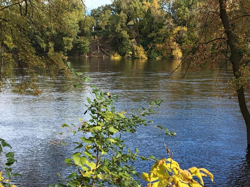
From the moment it trickles out of Minnesota’s Lake Itasca until it pours into the Gulf of
Mexico, the Mississippi River shapes the life of its region. It fosters cities and commerce;
transports people and goods; provides habitat for fish, plants, and wildlife; and enriches human
life with natural and recreational amenities.
Fashioned by eons of geologic and human activity, the Mississippi reflects the story of the
North American continent. Native Americans fished, hunted, traveled and settled along the
river; Seventeenth Century Europeans explored it; and cultural visionaries such as Mark Twain
implanted it in the American imagination as a symbol of freedom and adventure. The
Mississippi is a treasure in a multitude of ways: economically, environmentally, historically, and
culturally.
The Upper Mississippi watershed embraces millions of acres of land and waterways that drain
into the Mississippi, reaching from the western plains to the iron and copper ranges of the
Great Lakes. Drainage from the watershed’s marshes, bogs, wetlands, lakes, streams, and
rivers all seep into the Mississippi. Similarly, because water washes over the land on the way to
the river, activities on the land--from tilling the soil to harvesting trees to paving--also affect the
river. The river collects and carries whatever is drained, thrown, spilled, or discharged into it, as
well as substances that find their way into the watersheds lakes, streams, or aquifers. The
watershed of the Mississippi is a complex, dynamic and a mutually dependent system. People
downstream live with the activities of their upstream river neighbors.
Ecologically, the river is a watershed. Thus, river conservation efforts increasingly emphasize a
watershed approach. This means considering everything from urban development to
agricultural practices as factors in the health of the river. Drainage from marshes ditched for
farming or suburban development, chemicals applied to farm fields, and waste disposed from
households and industries all end up in the Mississippi. By the same token, efforts to clean up
or prevent pollution anywhere in the watershed can benefit the Mississippi directly or
indirectly.
Brooklyn Township grew slowly as vacation homes and country style neighborhoods began
appearing along the west bank of the Mississippi River. Activity along the river, natural tree
cover and vegetation, and the location of old U.S. Highway 169 spurred development in river
corridor through the first half of the 20th Century. The Village of Brooklyn Park was formed in
1954 as increased real estate activity caused land prices to rise and contributed toward the
construction of some of the highest quality homes in the early days of Brooklyn Park.
Residential development within the corridor has created a wide variety of housing styles.
Continued private investment has resulted in expansion and renovation of older homes. This
12-1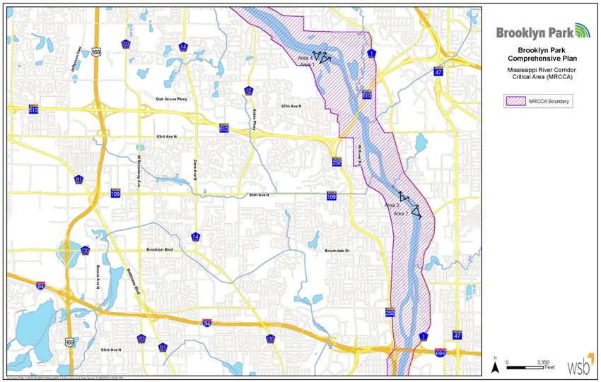
country estate style of living set a pattern of secluded low density residential development
which continues today.

The Critical Areas Act, passed by the State Legislature in 1973, established criteria for selection
of areas of the state that have critical environmental concerns and authorized the Governor to
designate critical areas, and require comprehensive planning for environmental protection,
future development and permit issuance.

In 1976, Governor Wendell Anderson established the Mississippi River Corridor Critical Area
(MRCCA) to protect and enhance the Mississippi River Corridor. The designation of the river
and its corridor as a Critical Area was reaffirmed and continued by Governor Albert Quie in
1979 through Executive Order 79-19 and made permanently a Critical Area by action of the
Metropolitan Council later in 1979.

New rules
guiding the land
planning and
regulatory
framework
began in 2009
and became
effective on
January 4, 2017
and replace
Executive Order
79-19. The rules
require that the
local
jurisdictions
update their
MRCCA plans
and ordinances
to be consistent
with the new
rules.

Figure 12.1 Communities included in the MRCCA

                                                                                                12-2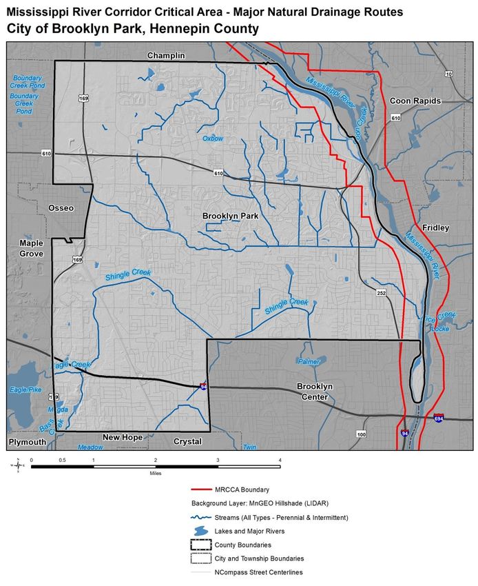
12.2 Goals of the Mississippi River Corridor Critical Area
Designated goals of the MRCCA program include:

1. Protect and preserve the Mississippi River and adjacent lands that the legislature finds to be
unique and valuable state and regional resources for the benefit of the health, safety, and
welfare of the citizens of the state, region, and nation;

2. Prevent and mitigate irreversible damages to these state, regional, and natural resources;

3. Preserve and enhance the natural, aesthetic, cultural, and historical values of the Mississippi
River and adjacent lands for public use and benefit;

4. Protect and preserve the Mississippi River as an essential element in the national, state, and
regional transportation, sewer and water, and recreational systems; and

5. Protect and preserve the biological and ecological functions of the Mississippi River corridor.

12.3 Process
Many community members were involved in the development of the rules through the state
process. The Issak Walton League, with local headquarters in Brooklyn Park, hosted a
community meeting to review the process of developing the plan, which is an update to the
existing approved plan. The public will have input opportunities at two planning commission
public hearings in the spring of 2018. As the plan is routed for adjacent community review the
public will also have opportunity to comment during this period. The new rules were adopted in
January of 2017 but the process for inclusion into the comprehensive plan was not available
until August 2017 and was changed as recently as February 2018. This did not allow a robust
stand- alone process for inclusion into the comprehensive plan.

12.4 Progress
The City of Brooklyn Park has accomplished many of the goals described in previously approved
plans including the Critical Area Plan and the Mississippi Stewardship plan. The following is a
partial list of accomplishments since plans have been adopted in the city.

1. “Edgetown Estates” converted an undeveloped tract of land in the corridor to 47 single
   family residential lots in 1997. The development contains properties within Brooklyn Park
   and Champlin. Coordination between the local governments and the Department of
   Natural Resources during the review process ensured high quality site design, preservation
   of natural features, and the use of best management practices in the construction of
   homes. All residential lots have been provided with public sewer and water facilities.

2. In 1980, there were 143 septic tanks in the Mississippi River corridor. Since that time
   utilities have been extended and are now available for all properties within the Mississippi
   River Corridor. Residential properties have been connecting to the public utilities system as
                                                                                                12-3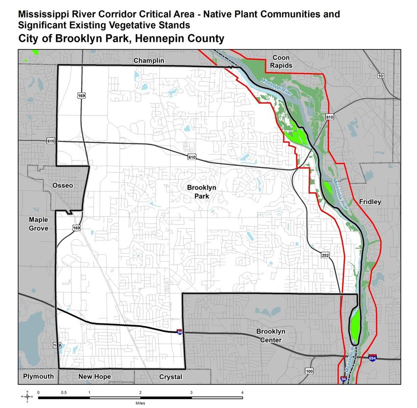
needed and as a part of development or redevelopment projects.

3. The Coon Rapids Dam underwent a comprehensive rehabilitation that was completed in the
   Spring of 2017. The new facilities maintain access across the dam and promote park
   visitation and recreational use. The Mississippi Gateway Regional Park will be part of a
   redevelopment planned by Three Rivers Park District.

4. In the summer of 1997, the City purchased approximately 13 acres adjacent to River Park.
   The park grew from 33 to 46 acres in size with nearly 2,000 feet of shoreline on the
   Mississippi River. Additional property was added in 2016 with the purchase of an adjacent
   property. The park is identified to have new facilities added that are more connected to the
   river. Plans also include treatment of area storm water that currently enters directly into
   the river through a treatment train on the south side of the park. Ponding treatment was
   added on the north end of the park in the early 2000’s.

5. Implementation of the Village Redevelopment Plan has resulted in acquisition of land
   adjacent to Shingle Creek for open space and extension of the City Trail System through the
   Brooklyn Boulevard / Zane Avenue corridor. Stabilization techniques have been employed
   along the banks of Shingle Creek with landscaping, ponding, and other improvements
   installed to help increase the health of the creek.

6. Several improvements have been made to the transportation system within the river
   corridor including Trunk Highway 252, construction of the Highway 610 bridge and
   reconstruction of West River Road. The improvements provided storm water management
   controls as required at the time. This has provided treatment for run-off that had
   historically gone directly into the river.

7. Mississippi Gardens is a private commercial facility that was constructed at the front edge
   of the footprint of an old structure dating back to the early 1900’s. The site is adjacent to
   the Highway 610 Bridge. The new construction and landscaping has a nicer appearance. The
   facility provides beautiful views of the river and captures these from both the interior and
   exterior of the building. Storm water now has some pre-treatment before entering the river
   with the addition of swales and a rock spillway to help with erosion.

12.5 Districts
The 2017 MRCCA rules established six new districts that more accurately represent existing and
planned future development along the 72-mile stretch. The six districts include: Rural & Open
Space District, River Neighborhood District, River Towns and Crossings District, Separated from
River District, Urban Mixed District, and Urban Core District. Each of the districts reflects the
character and development along the river and recognizes planned and future development.
Different dimensional standards (building height, river setback, and bluff setback) are applied to
each district. These standards are administered through local zoning ordinances, and some
provisions default to the standards outlined in the district’s underlying municipal zoning
regulations.
                                                                                              12-4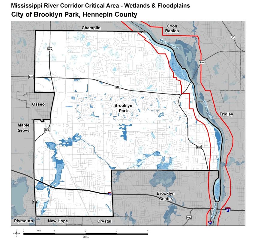
These districts are important for managing the MRCCA because they help protect the
Mississippi River as a natural and cultural resource. The standards defined in each district take
the existing characteristics into account and keep buildings and other structures away from
sensitive shoreline areas and areas prone to soil erosion and slope failure. Keeping a distance
between sensitive shoreline areas and the development helps to maintain the river’s water
clarity and quality and reduce sediment runoff. Height provisions help to preserve the natural
views within the corridor.

In Brooklyn Park we have three districts designated for land in the corridor:

1. River Neighborhood District (CA-RN) - Developed residential lands and existing/planned
   parkland that are visible from the river, or that abut riparian parkland. The CA-RN district
   must be managed to maintain the character of the river corridor within the context of
   existing residential and related neighborhood development, and to protect and enhance
   habitat, parks and open space, public river corridor views, and scenic, natural, and historic
   areas Minimizing erosion and the flow of untreated storm water into the river and
   enhancing habitat and shoreline vegetation are priorities in the district.
2. Separated from River District (CA-SR) - Land that is separated from and not visible from the
   river. The CA-SR district provides flexibility in managing development without negatively
   affecting the key resources and features of the river corridor. Minimizing negative impacts
   to primary conservation areas and minimizing erosion and flow of untreated storm water
   into the Mississippi River are priorities in the district.
3. Rural & Open Space District (CA-ROS) – Rural undeveloped and developed low density
   residential land that is riparian or visible from the river, often contains tracts of high quality
   ecological resources. The CA-ROS district must be managed to sustain and restore the rural
   and natural character of the corridor and to protect and enhance habitat, parks and open
   space, public river corridor views, and scenic, natural, and historic areas.

The land along the corridor is private single family residential use, public land, and a small
commercial area. The underlying zoning is not proposed to change in the corridor but will utilize
an overlay to apply new rules.

                                                                                                 12-5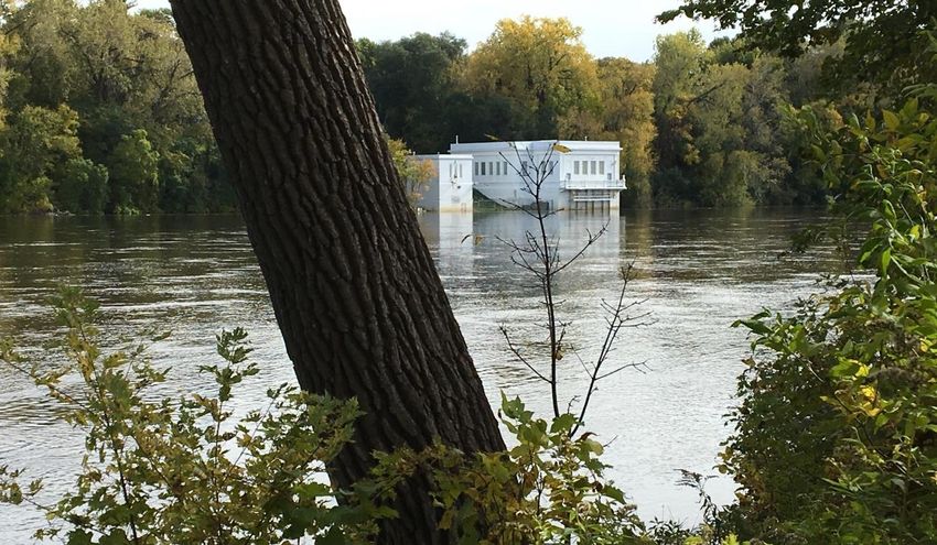
Figure 12.2 Mississippi River Corridor Critical Area Districts

12.6 Primary Conservation Areas (PCAS)
The term primary conservation areas (PCAs) defines the key natural and cultural resources and
features that are addressed by the MRCCA rules. This term includes natural and cultural
resources and features listed in the statute into a single definition and includes such features as

                                                                                               12-6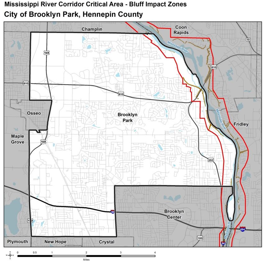
bluffs and bluff impact zones, cultural and historic properties, shore impact zones, natural
drainage ways, native plant communities, etc.

A. Shore Impact Zone:

    The land along the water’s edge is environmentally sensitive and needs special protection
   from development and vegetation removal. The shore impact zone is a “buffer” area
   between the water’s edge and the area where development is allowed. This area is
   generally 50 percent of the building setback which is 100 feet. So, it is the area 50 feet wide
   between the normal water’s edge and the minimum building setback.

B. Flood plains and wetlands:
   Brooklyn Park’s flood plain within the Mississippi River Corridor has different characteristics
   above and below the Coon Rapids Dam. Water elevation of the six-mile pool above the dam
   is monitored and controlled. The river front area contains both private residential
   properties and public land. A gentle slope from bluff lines to the waterline protects
   residential properties from experiencing flooding problems.

   Below the dam, the majority of flood plain areas are protected by public land in the
   Mississippi Gateway Regional Park and River Park. Residential properties between the
   regional park and River Park have steep slopes that protect homes built above bluff lines.
   South of River Park, residential properties have been subdivided to allow homes to be
   located safely outside of the flood plain with a few exceptions immediately south of River
   Park. Current floodplain regulations restrict new construction within the flood plain.
   Elevations for flood plains are noted on the officially adopted Flood Insurance Rate Map.

   Wetland inventories have been completed by the U.S. Fish and Wildlife Service as published
   on the National Wetlands Inventory Maps, and by the Minnesota Department of Natural
   Resources as published in their Protected Waters Inventory. Many of the wetlands have
   changed characteristics in the community and no longer meet the definition although may
   still be protected. The city has worked with the DNR to identify and protect, replace or
   modify the wetlands as allowed.

C. Unstable soils and bedrock

   The City is unaware of any probable areas of unstable soils or bedrock.

                                                                                               12-7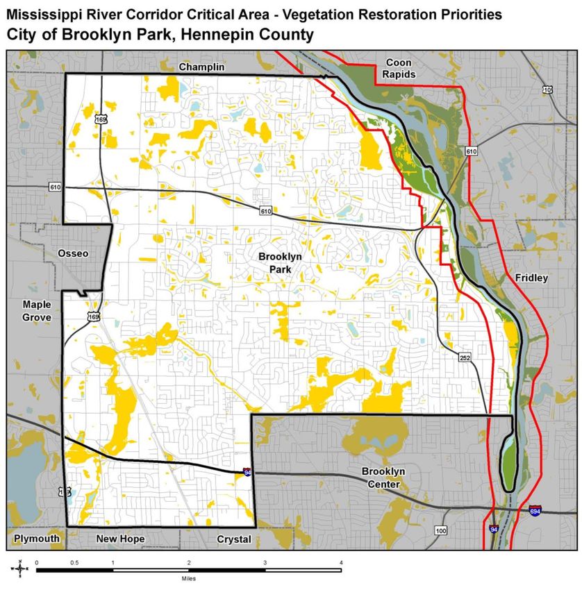
Figure 12.3 Critical Corridor Wetlands & Floodplains

                                                       12-8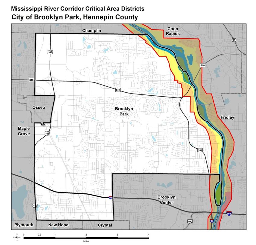
Natural Drainage Ways are mapped below and show historical or existing drainage routes.
Some of the routes are not natural and are manmade stormwater conveyance systems that
may have replaced historically natural systems

Figure 12.4 Corridor Critical Area Major Natural Drainage Routes

                                                                                          12-9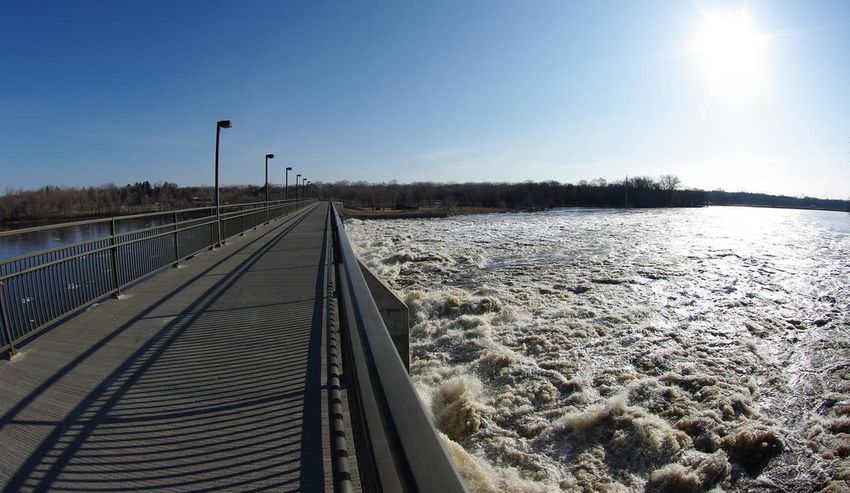
D. Bluffs & Bluff Impact Zones. The protection of bluffs in the MRCCA is important to reducing
   erosion and slope failure, as well as maintaining wildlife habitat, native vegetation and the
   corridor’s scenic character. As a PCA, bluffs and the associated bluff impact zones within 20
   feet of the bluffs are regulated by the MRCCA program.

Figure 12.5 Corridor Critical Area Bluff Impact Zones

                                                                                           12-10
E. Native Plant Communities and Significant Vegetative Stands. The majority of the areas are
on public land.
Figure 12.6 Native Plant Communities and Significant Existing
Vegetative Stands
12-11F. Vegetation Restoration Priorities
Provided below is a map indenting area deemed priorities for vegetation restoration by the
Minnesota DNR. When and where feasible, the City will coordinate with the DNR and other
participating agencies in the restoration of vegetation within the MRCCA.
Figure 12.7 Vegetation Restoration Priorities
12-12G. Cultural and Historical Resources
Residents of Brooklyn Park. Property owners within the river corridor have,
through significant private investment, have made improvements to properties
that have created healthy residential neighborhoods and preserved many of the
natural resources within the corridor.
Camden-Brooklyn Township-Anoka Stage. One of the first Twin City area stage
runs was a horse and wagon which made daily trips between St. Paul and St.
Anthony in the mid-19th Century. The route included a local stage that also made
daily runs between Camden and Anoka in the morning and afternoon. Four
horses pulled the stage as it traveled the narrow gravel West River Road through
Brooklyn Township to Champlin and then across the Mississippi River Bridge and
the Rum River Bridge to Anoka. In the spring, it was not uncommon to see men
in the fields with a wooden plow, pulled by oxen, preparing the fields for
planting.
About halfway through the journey, the stage would stop to allow the horses to
rest at what came to be called the ‘Half-way House’ in Brooklyn Township. The
house, converted from a farmhouse in 1873, was opened to the public in 1874
and continued to operate as a rest area for travelers until 1912. The ‘Half-way
House’ could be easily identified by the six-inch white board siding from local
mills. The house still stands alongside West River Road today, just north of 85 th
Avenue, and is still owned by the Mattson Family.
Great River Road. Great River Road is a national landmark for travelers in the
Mississippi River Corridor from Itasca State Park in Minnesota down through
Louisiana and to the Gulf of Mexico. Great River Road enters Brooklyn Park on
Trunk Highway 252 and follows 252 north to Brookdale Drive. The route turns
east at Brookdale Drive and proceeds to West River Road. The route then turns
north and follows West River Road to 97th Avenue. At Russell Avenue the route
turns north and connects with West River Road again and follows West River
Road into The City of Champlin. A map of the entire route, including tourist
information, is available from the Mississippi River Parkway Commission of
Minnesota.
Local chapter of Izaak Walton League. The Izaak Walton League is a national
conservation organization dedicated to preserving and enhancing natural areas.
The Local Chapter is located at 8816 West River Road. Izaak Walton, writer and
naturalist was born in Stafford, Staffordshire, England, UK. In 1621 he settled in
London as an ironmonger but left the city for Staffordshire during the Civil War,
12-13and after the Restoration lived in Winchester. He is best known for his treatise
on fishing and country life, The Compleat Angler (1653), he also wrote several
biographies.
12.7 Public River Corridor Views (PRCVS)
The City of Brooklyn Park is fortunate to have a series of public locations from which residents
and visitors can view the Mississippi River. Those areas are shown on Map It is important that
both the City and adjacent communities work together to preserve and where possible enhance
these views.
Area 1. Trail across the dam connecting Anoka and Hennepin County
This is a valuable view and location due to its function as a pedestrian connection across the
Mississippi River and thus its ability to provide views of the river from any location along the
top of the dam. Dam alterations that would affect pedestrian accessibility would alter the
ability for residents and visitors to utilize this amenity would negatively affect its ability to
provide a viewpoint of the river. Additionally, reductions in vegetation, water quality, or blight
would negatively affect the views from this PRCV.
12-14Area 2. Public View from River Park of water intake facility supplying water to St. Paul
This view is from River Park which is a large public park in the City which borders along the
Mississippi River. This is a valuable view as it provides a point from which to view the historic
water intake facility. Additionally, its location due to its ability to directly connect people to the
river’s edge is a positive amenity. Riverbank erosion would negatively affect accessibility and
thus limit residents and visitor’s ability to utilize this amenity. Additionally, reductions in
vegetation, water quality, or blight would negatively affect the views from this PRCV.
12-15Area 3. Bluff across the river in Fridley
This public river corridor view provides a view of the bluff across the river in the City of Fridley
which includes single family residential homes. The ability to protect the slopes and prevent
riverbank erosion is important as both would negatively affect the views from this PRCV.
12-16Area 4. View of the Pool
This view of the pool above the dam is unique in that it provides a lake like setting along the
Mississippi River. The uniqueness of this pool along on an otherwise flowing river is valuable in
itself and the views of single-family homes and cabins set within dense vegetation further
cements a north woods like view. Riverbank erosion would negatively affect accessibility and
thus limit residents and visitor’s ability to utilize this amenity. Additionally, reductions in
vegetation, water quality, or blight would negatively affect the views from this PRCV.
12-17Figure 12.8 Location and viewshed of Public River Corridor Views (PRCVs)
12-1812.8 Transportation and Public facilities
Transportation System
The Mississippi River Corridor transportation system is primarily comprised of local streets that
connect residential neighborhoods to north-south routes like West River Road and Trunk
Highway 252. Brookdale Drive and 85th Avenue are east-west routes classified as arterial
roadways in the corridor. Improvements to the roadway system include construction of the
610 bridge, reconstruction of West River Road including a regional trail, and construction of a
pedestrian bridge over Trunk Highway 252.
610 Bridge
The 610 (Richard Braun) Bridge was constructed to provide an intermediate river crossing
between the Anoka Bridge (TH 169) and Interstate 694. An Environmental Impact Statement
and cooperation between local, county and state agencies ensured that the design of the
bridge minimized impacts on the natural features of the river corridor and provided mitigation
for areas that were disturbed during construction. The new bridge was designed to match an
existing bridge and include trail access across the river to link Brooklyn Park, Three Rivers Park
District, and Anoka County trail systems.
Trunk Highway 252
Trunk Highway 252 was relocated outside the Mississippi River Critical Area in 1986. The new
alignment allowed expansion from a two to four lane system. Due to funding and timing
constraints, the new highway system was constructed as an on-grade facility with four
controlled intersections. Relocation of Trunk Highway 252 has allowed West River Road to
revert to a collector street for the residential neighborhoods of the corridor and was
reconstructed at 28 feet in width and posted with a 30-mph speed limit. A multi-jurisdictional
study is currently underway for conversion of Highway 252 into a freeway.
Pedestrian Bridge
As traffic levels on Trunk Highway 252 increased, the highway created a barrier that prevented
pedestrian traffic and the City’s trail system from reaching the Mississippi River. In the summer
of 1999, a tragic accident claimed the life of Kara Kavanaugh, a young girl who attempted to
cross the highway at the 85th Avenue intersection. That tragedy resulted in an outpouring of
community support and volunteerism that created a benefit concert and an ongoing
community effort to raise money for the pedestrian bridge. The ‘Building a Bridge’ fund was
created with the help of residents and local businesses. The funding was secured, and the
bridge was completed in 2004.
West River Road Reconstruction
12-19Relocation of Trunk Highway 252 has allowed West River Road to revert to a collector street for
the residential neighborhoods of the corridor. A street reconstruction project converted
approximately 4 miles of West River Road from rural to urban street design with curb and
gutter. The project began at Brookdale Drive and ended at 97th Avenue and includes a 3.6-mile
section of the Great River Road. The existing ditch storm sewer system was converted to a
conduit (pipe) storm sewer system and integrated into the city storm water system.
The West Mississippi River Regional Trail, A ten-foot-wide bituminous trail was constructed on
the west side of the roadway. The trail connects to existing trails south of Brookdale Drive to
allow access through Brooklyn Center to the Minneapolis trail system and links Mississippi
Gateway Regional Park and provides a second river crossing at the Trunk Highway 610 Bridge.
The roadway and trail are enhanced with parkway style landscaping and decorative lighting.
Residential Streets
Some local streets within the corridor continue to have a rural street design but many have
been converted to an urban section. The roadways are inspected as part of a roadway
classification system that ranks roadways according to their condition. A proposal to overlay or
reconstruct a roadway is made to the affected neighborhood based on the condition of the
roadway. Extension of storm sewer, sanitary sewer and water lines is a part of all street
reconstruction projects. No new private septic systems are allowed once municipal sanitary
sewer service is available.
Transit
There is one Metro Transit route in the Mississippi River Corridor. It provides morning and
afternoon bus service beginning in the cities of Anoka and Champlin and follows West River
Road into Downtown Minneapolis. In Brooklyn Park, bus stops are located along West River
Road, Russell Avenue, and 97th Avenue. Stops are also made at park and ride facilities at the
northwest corner of T.H. 610 and Noble Parkway.
Commercial Activity
There is currently no commercial activity or barge fleet traffic on the Mississippi River within
the municipal boundary of the City of Brooklyn Park.
Other Public Facilities
Electric power is provided by the substation located adjacent to the Coon Rapids Dam. The
substation powers transmission lines that provide electricity throughout Brooklyn Park and
surrounding communities.
Sanitary Sewer System
12-20Both Municipal and Metropolitan Council sanitary sewer facilities exist in Brooklyn Park.
Sanitary sewer service is available for all properties in the Mississippi River Corridor. Municipal
sanitary sewer service will be extended to the remaining properties as a part of a public
improvements project that is either requested by the neighborhood or necessary as private
systems begin to fail. The Metropolitan Council Environmental Services Interceptor line enters
the corridor at 92nd Avenue and continues south through the corridor before turning west and
exiting the corridor adjacent to Brookdale Drive.
Storm Sewer System
Existing storm sewer facilities are located throughout the corridor to provide for the collection
and transmission of storm water that is not conveyed by the topography of the corridor. Six
man made and two natural discharge points allow storm water to enter the Mississippi River in
Brooklyn Park. The design and maintenance of these facilities is governed by the
Comprehensive Stormwater Management Plan and applicable state and federal regulations.
Storm water retention ponds exist to absorb and filter the water before allowing it to reach the
river north of 89th Avenue. Additional ponding areas will be created as development or
redevelopment occurs.
Municipal Water System
Water service is available for all properties in the corridor except for properties along the river
between 81st and 86th Avenues. This neighborhood has not petitioned the City for water
service, so private wells will continue to provide water for these properties unless a public
petition is filed with the City or a public health concern arises.
River Crossings
At the present time, the Mississippi River is crossed by four power line easements and the T.H.
610 bridge. Three of these easements meet at the Xcel Energy Substation located adjacent to
the Coon Rapids Dam. The fourth easement has a 345 KV line constructed on it and is located
1.5 miles to the south. All river crossings will be located in existing easements whenever
possible and alternatives to additional river crossings will be explored prior to designing
additional river crossings.
Electric Power Generating Facilities
At the present time, there are no existing principal use commercial solar or wind facilities
within the boundary of the MRCCA in the City. The City is also not currently aware of any
planned principal use commercial solar or wind facilities. Land within the MRCCA boundary is
zoned as either R2, R2b, R3, R4, R5, R6, B2, B3, or P/I (public / institutional).
Solar energy systems in accordance with standards set forth in the city’s zoning ordinance are
allowed as a permitted accessory use in all zoning districts. They are not however permitted as
a principal use. Roof mounted solar energy systems are required to comply with the maximum
12-21height requirements in the applicable zoning district. Ground mounted solar energy systems are
not permitted to exceed 15 feet in height. Subsequently, those height limitations for roof and
ground mounted solar energy systems limit the potential impact they could have on area
PRCV’s.
Utility wind turbines are not permitted in any of the zoning districts within the MRCCA
boundary; however, small wind turbines are allowed as an accessory use in all business
districts, and nonresidential uses in commercial districts. The height of small wind turbines in
business districts shall not exceed 75 feet. Residential turbines (only vertical axis style
permitted) are allowed as an accessory use in all residential districts. Residential wind turbines
can be either building mounted a maximum height of 15 feet above the roofline of the principal
structure; or mounted on a tower a maximum height of 20 feet above the roof line of the
principal structure. Poles must be connected to the principal structure and cannot be
freestanding. All residential wind turbines are required to be of the vertical axis style.
Height limitations for both small wind turbines in business districts and residential turbines
within residential districts as well as height limitations for roof mounted and ground mounted
solar energy systems limit the potential impact they could have on PRCV’s. Additionally,
because neither solar or wind energy systems are permitted as a principal use they’re potential
to impact PCA’s is also greatly reduced.
Essential Services and Transmission Services:
Currently there are four power line crossings in the City within the MRCCA boundary. These
power lines have an effect on the aesthetic of PCAs and PRCVs; however, their size limits that
effect. Ultimately, those power and transmission lines are a critical and necessary component
of the City’s power infrastructure.
12.09 Water-Oriented Land Uses
A boat landing is available for the general public off of 83rd Avenue N within River Park. The
boat landing has space available for truck and trailer parking and also has kayaks available for
rent through the Mississippi River Paddle Share Program. The put-in station at River Park is one
of a few stations located along the Mississippi River and is a partnership with the Three Rivers
Park District. The boat landing provides an important public access to the river. The City is
currently undertaking a new master plan for River Park that will seek to provide passive
recreational opportunities for area residents. River Park provides an important buffer to
residential properties that may have otherwise been negatively affected by traffic generated by
the boat launch. Boat speeds may have a negative effect on shoreline erosion both above and
below the Coon Rapids Dam; however, the City does not intend to regulate surface water uses.
12-22Mississippi Gateway Regional Park: it encompasses a total of 267 acres and offers both
Brooklyn Park residents and regional visitors a unique opportunity to observe the “Mighty
Mississippi” up close. The City of Brooklyn Park owns and operates the Environmental Nature
Area (96.5 acres) located directly across West River Road from each other and are connected
via the Rush Creek Regional Trail. The Three Rivers Park District and the City of Brooklyn Park
formed a partnership to develop a join master plan that incorporates both parks with the goal
for the two parks to seamlessly function as one: namely Mississippi Gateway Regional Park.
12.10 Goals
Goal #1: Preserve and enhance the natural environmental characteristics and scenic qualities of
the Mississippi River corridor.
Goal #2: Maintain the existing high quality residential and recreational environment provided
with the river corridor.
Goal #3: Increase opportunities for City residents and the general public to use the river
corridor as a recreational resource.
Goal #4: Achieve and maintain water quality conditions conducive to recreational activity and
propagation of aquatic life.
Goal #5: Work with property owners to replace diseased trees with new plantings and
introduce appropriate vegetation on river banks and steep slopes to control erosion.
Goal #6: Design systems to improve water quality and ensure elimination of non-point sources
of pollution.
Goal #7: Achieve enhanced shoreline restoration, tree preservation and replacement, water
quality management, and erosion control in the corridor.
Goal #8: Promote the economic benefits of the river corridor including tourism and closer
coordination with Three Rivers Park
Goal #9: Continue to use intergovernmental cooperation and education to address corridor
issues and to increase public appreciation of corridor resources.
12.11 Policies
12-23The following general policies for protection, preservation, and management of the river
corridor reflect the direction of the goals outlined:
Policy #1: The Mississippi River is a working river and as such is important to the local, state,
and regional economy. As such, the river corridor is a unique and valuable regional, state, and
national resource.
Policy #2: Protect and preserve the working river corridor for the benefit of the economic,
health, safety, and welfare of residents of the city, region, state, and nation.
Policy #3: Prevent and mitigate irreversible damage to the river corridor.
Policy #4: Protect and preserve the biological and ecological functions of the river corridor.
Policy #5: Manage the river corridor in accordance with all applicable state and federal
regulations.
Policy #6: Provide an uninterrupted vegetated shoreline where practical by encouraging
preservation and replacement of natural plant materials as well as the restoration of native
plant communities where and when feasible.
Policy #7: Control and prevent riverbank erosion by regulating preservation of shoreline
vegetation, encouraging restoration/replacement of lost shoreline vegetation with native plant
materials, and encouraging installation of systems to control existing areas of erosion.
Policy #8: Install appropriate erosion control measures at all City storm water management
facilities and manage surface water drainage to maintain river water quality.
Policy #9: Improve quality of surface water runoff received by streets and watercourses through
Best Management Practices and manage the use of chemical fertilizers on public lands and
application of salt to streets in winter.
Policy #10: Minimize site alteration within the corridor.
Policy #11: Preserve natural areas within parks and open space while allowing some
intensification of use. Encourage creation, connection, and maintenance of open space,
recreational facilities, including those providing public access to the river.
Policy #12: Where practicable preserve or restore a 40-foot wide zone of vegetation along the
shoreline and protect and where and when possible, enhance Public River Corridor Views
(PRCVs).
Policy #13: Where practicable prohibit disturbance of bluff faces with slopes of greater than
12%.
Policy #14: To help review impacts to the river bluff, PRCVs, or vegetation stands, a detailed
topographic survey will be required for all new construction/reconstruction if deemed
12-24necessary after construction/reconstruction. The city will coordinate with adjacent jurisdictions
to protect PRCVs located within and identified by communities adjacent or across the river.
Policy #15: All new development or redevelopment requires a site plan that adequately assess
and minimize adverse impacts to PCAs. The city will consider on a case by case basis the
support of subdivisions/PUDs, variances, CUPs, and other permits which could assist in the
protection of PCAs and PRCVs. Proposed developments will be evaluated for erosion
preventions and bank and slope stabilization issues and require restoration as part of the
development process.
Policy #16: The city will develop zoning regulations that support the polices and rules outlined
by the MRCCA
Policy #17: The city will notify the Department of Natural Resources at least 30 days before
taking action on any development requiring discretionary action or a public hearing by the City.
Policy #18: The city will continue to guide land use consistent with the management purposes
of the MRCCA districts.
Policy #19: Protect the Primary Conservation Areas (PCAs) and Public River Corridor Views
(PRCVs) listed in the City’s MRCCA plan and minimize impact to PCAs from public and private
development and land use activities (landscape maintenance, river use, walking/hiking, etc.).
Policy #20: The city will consider alternative design standards that protect the LGU’s identified
PCAs through zoning and site design techniques that achieve better protections or restoration
of primary conservation areas.
Policy #21: When feasible the city will pursue permanent protection measures such as public
acquisition, conservation easement, deed restrictions to protect PCAs as a high priority.
Policy #22: Protect native and existing vegetation during the development process and require
restoration if any is removed by development. Priorities for restoration shall include
stabilization of erodible soils, riparian buffers and bluffs or steep slopes visible from the river.
Policy #23: When feasible, the city will seek opportunities to restore vegetation to protect and
enhance PRCVs identified in this plan.
Policy #24: When feasible, the city will seek opportunities to restore vegetation in restoration
priority areas identified in this plan through the CUP, variance and subdivision/PUD processes.
Policy #25: The city will sustain and enhance ecological functions (habitat value) during
vegetation restorations.
Policy #25: The city will identify and encourage connection of CA-SR district land to existing and
planned parks and trails for LGUs with developable land in CA-SR districts.
12-25Policy #26: Where feasible and appropriate, the city will encourage that land dedication
requirements be used to acquire land suitable for public river access.
Policy #27: The city will minimize impacts to PCAs and PRCVs from solar and wind generation
facilities, public transportation facilities and public utilities.
Policy #28: The city will protect water-oriented uses and work to minimize any potential
conflicts of water-oriented uses with other land uses.
12.12 Implementation Plan
Implementation Action Responsible Group Anticipated
Completion Date
Districts
Update Zoning Map to reflect new GIS Staff 2019
MRCCA districts Planning Staff
Adopt new MRCCA ordinance Planning Staff 2020
Primary Conservation Areas
Make the location of PCAs readily Planning Staff 2020
available to residents and provide
relevant ordinance information for
items such as vegetation
management and land alteration
permits.
Establish procedures and criteria Planning Staff 2020
for processing applications with Engineering Staff
potential impacts to PCAs,
including:
1. Identifying the information
that must be submitted and
how it will be evaluated.
2. Determining appropriate
mitigation
procedures/methods for
variances and CUPs,
3. Establishing evaluation
criteria for protecting PCAs
when a development site
contains multiple types of
PCAs and the total area of
PCAs exceed the required set
aside percentages.
12-264. Developing administrative
procedures for integrating
DNR and local permitting of
riprap, walls and other hard
armoring.
Public River Corridor Views
Make the location of Public River Planning Staff 2020
Corridor Views (PRCVs) readily
available to property owners to
understand how PRCV-relevant
ordinance requirements such as
vegetation management and land
alternation permits apply to their
property for projects and
permitting.
Establish procedures for Planning Staff 2021
procession applications with
potential impacts to PRCVs
including:
1. Identifying the information
that must be submitted and
how it will be evaluated, and
2. Determining appropriate
mitigation
procedures/methods for
variances and CUPs
3. Actively communicate with
adjacent communities to
protect views identified as
valuable.
Restoration Priorities
Planning Staff 2020
If areas are identified as natural
vegetation restoration areas, the
City will provide information on
their location and make readily
available to property owners
ordinance requirements that apply
to their property for project
planning and permitting.
Establish a vegetation permitting Planning Staff 2021
process that includes permit
12-27review procedures to ensure
consideration of restoration
priorities identified in this plan in
permit issuance as well as
standard conditions requiring
vegetation restoration for areas
identified as priority areas.
Establish a process for evaluating Planning Staff 2021
priorities for natural vegetation
restoration, erosion prevention
and bank slope stabilization, or
other restoration priorities
identified in this MRCCA plan in
CUP, variances and
subdivision/PUD processes.
Open Space & Recreational Facilities
Include improvements for open Recreation and Park Staff 2019
space and recreational facilitates Operation and Maintenance Staff
within the MRCCA boundary in the Planning Staff
Capital Improvement Program.
Develop a system for reviewing, Planning Staff 2019
tracking, and monitoring open
space required as part of the
subdivision process.
Transportation & Public Utilities
Include transportation facilities, or Engineering Staff 2019
portions of facilities, located Planning Staff
within the MRCCA boundary to
the Capital Improvement Program
Incorporate specific design and Planning Staff 2019
placement conditions into local
permits for solar and wind
generation facilities and essential
and transmission services that
minimize impacts to PCAs and
PRCVs.
Water-Oriented Land Uses
When adopting an MRCCA Planning Staff 2020
ordinance, provide regulations for
water-oriented land uses.
12-28You can also read