Classification of the Cilento,Vallo Diano and Alburni National Park-European Geopark Coastland
←
→
Page content transcription
If your browser does not render page correctly, please read the page content below
Latest Trends in Energy, Environment and Development
Classification of the Cilento,Vallo Diano and Alburni National Park-
European Geopark Coastland
DOMENICO GUIDA1, ANIELLO ALOIA2 & ALESSIO VALENTE3
1
Department of Civil Engineering, University of Salerno, Fisciano (SA), ITALY, dguida@unisa.it
2
Cilento,Vallo Diano and Alburni National Park-European Geopark, ITALY, a.aloia@cilentoediano.it
3
Department of Sciences and Tecnologies, University of Sannio, Benevento, ITALY, valente@unisannio.it
Abstract: In order to address innovative approaches for best conservation practices and sustainable use of
marine and coastal geosites, this paper proposes a classification scheme and distinctive evolutionary model for
representative carbonate, terrigenous and clastic rocky coast and marine nearshore geosites of the Cilento,
Vallo Diano and Alburni National Park-European, based on original analysis and international standards.
Key words: Coastal geosite, rocky coast classification, Cilento European Geopark, Southern Italy.
1. Introduction In addition, Global (Climate) Change and related
The Cilento European Geopark has one of the most level sea variation induce further disturbance in a
fascinating and appreciated coastlands in the very large space-time span [1]. All the previous
Mediterranean countries and thus contains many considerations help in a better understanding of the
coastal and marine geosites. coastal system in order to perform appropriate
It is characterized by physical, flora, and fauna actions for coast protection, conservation,
diversity, with mild and rainy winters and hot, dry sustainable mitigation and remediation. In this
and prolonged summers. The historical human direction, major efforts have been lavished by
occupation in the last millennia has created a very scientific and public institutions in researches and
attractive scenery and, locally, a unique cultural interventions on shorelines and beaches erosion
landscape (Fig. 1), constituting one of the major remediation, because of their great economic
social-economic factor in the Geopark. In the last importance in tourism and recreation. Little
decades, the Geopark coastland has suffered an attention have been given, instead, to the rocky and
increasing human pressure due to civil settlements cliff coast, although their spatial extension,
as well as tourist infrastructures, resulting in a hazardous characters and scenery relevance. Rocky
hazard for humans, in damaged habitats and in coastlands constitute relevant areas of the network
losses for the landscape heritage (Fig. 2). of protected areas, as Marine Reserves and to assess
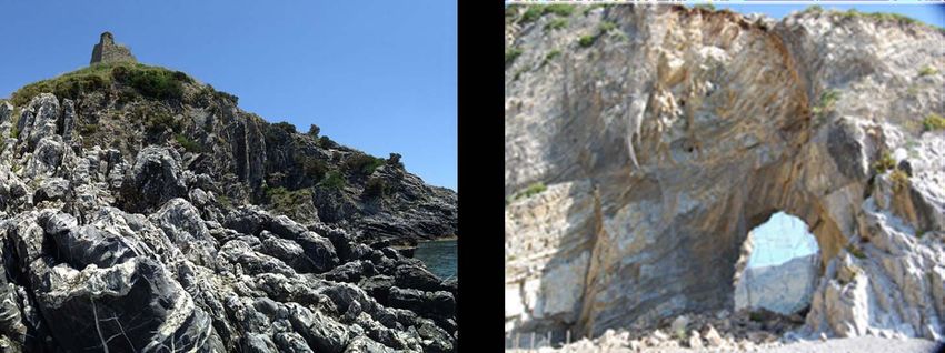
Figure 1: “Telegraph Cape”, a fascinating geosite with an ancient tower on the top,
Figure 2: “Palinuro Natural Arch” damaged by rockfall event in 2011
ISBN: 978-960-474-375-9 121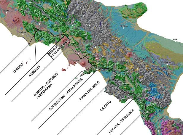
Latest Trends in Energy, Environment and Development

rocky coast landscape characters, natural ecosystem             According with Cinque and Ascione [12], the
resources and specific hazardous areas become more              coastland in Campania represents the peri-
and more essential to increase studies and                      Tyrrhenian sector of the Campano-lucanian Arc in
researches in rocky coast environment. Following                the Southern Apennine Chain. This represents a
Sunamura [2], a rocky coast may be defined as a                 segment of a larger fold-and-thrust belt built up in
coast that is cliffed and yet composed of                       Central Tethys between late Cretaceous and
consolidated material irrespective of its hardness;             Pleistocene, as consequences of interaction between
these shores are thus commonly characterized by                 the European and African plates, spreading of the
cliffs of various types and associated subjacent                Tyrrhenian oceanic basin and anti-clockwise
platforms [3]. Recently, international organizations ,          rotation of the orogenic front [13]. Due to long-time
for instance, Unesco [4], IUCN Protocol [5] [6] and             and complex litho-genetic history, tectono-
Council of Europe [7] [8], have shifted their                   sedimentary events and orogenic displacements,
attention and recommendations from a site-based                 several litho-stratigraphic units can be distinguished
and disciplinary problem approach to worldwide                  (Fig. 3).
approach (so called “Ecological Approach”) at                   The Internal Units, Mesozoic to Tertiary aged,
broad scale [9]. In order to define rocky coast as              [14] [15] are made up at the base prevalently by
“interacting complex landscape” between physical,               marly, varicoloured clay, in oceanic plain
biological and human factors at broader scale, the              sedimentary facies, passing above in calcarenites,
first step should be to assess the basic physical               calcilutites, often cherty, argillites, sandstones and
characteristics [10], such as climate, geological and           rare conglomerate deposited in a distal turbidite
geomorphological units in term of typology together             setting. The External Units constitute mainly by
with a hierarchical space-time classification. The              carbonate sediments of Mesozoic and Tertiary age
paper deals with a preliminary typology and                     which show sedimentary environments going from
hierarchical classification of the rocky coast in               the shallow water carbonates with back-reef facies
Cilento Geopark coastland, based on the general and             to slope and deep water carbonates [16] [17]; they
more shared classification criteria [2] and local-              constitute the bedrock of major cliffed rocky coast
based experienced applications, within the ICAM                 in the Sorrento Peninsula, as well as in the southern
protocol [6], overcoming the littoral cell concept              of Cilento. In disconformity on the previous units
and on modelling of local hydrodynamic processes                there are the Neogenic Sinorogenic Units,
and considering an integrate approaches to assess               represented by several terrigenous formations and
coastal evolution taking into account space, time               units referred to Miocene age in turbidite facies,
and scale [11]. The approaches have been used to                from wild-flysch to submarine fan sedimentary
provide an analysis of present day setting as a                 characters. For instance, Cilento Group [18] [15] is
dynamical result of a past and long-term evolution              one of these units, which is most widespread in the
for the selected coastal segments of Geopark. In this           homonymous area and along the corresponding
paper, rocky coastal cliffs in Geopark,                         coast. The Quaternary Postorogenic Units include
representative of analogous landforms in Southern               all the continental, transition and marine clastic
Italy, are analyzed in order to define their main               sediments, deposited after the final emersion of
characters, classification and morpho-evolutionary              Apennine Chain (Late Pliocene-Early Pleistocene)
outlines. The key outputs from this research are: i)            [17]. They are represented by aeolian, fluvial,
Improved understanding of mid-to-long term coastal              piedmont, lacustrine and travertine deposits along
behaviour; ii) assessment of rocky coast evolution to           the river valleys and coastal plains, but also they
modelling future scenarios, and supporting regional             form local cliffs in Cilento. Such units can show
information and local data to planning and                      intercalation of the products of the campanian
management policies.                                            volcanic activity. The above geological and tectonic
                                                                setting, induce a prevalent morpho-structural control
                                                                of the geopark rocky coastland, with rocky cliffs
2. Geological and geomorphological                              resulting from retreat and replacement of the
   coastal setting                                              previous fault scarps and fault-line scarps (Fig. 3),
The outline of the coast of the Cilento Geopark, part           alternating to terraced plains and shorelines Based
of Campania coast, is very complex with long,                   on tectonical, lithological and morphological
rectilinear coastal plains, pocket beaches, prolonged           characters several geomorfological Coastal Systems
headland and sharp cliffs. Small slands and little              [19] can be recognized. Bulgheria Mt., in the
stacks are also present near-shore and off-shore.               southern Cilento Geopark are representative of

    ISBN: 978-960-474-375-9                               122
Latest Trends in Energy, Environment and Development
Figure 3 - Southern Campania Geological Setting. Legend 1: Quaternary Postorogenic Units;2: Volcanic
Units; 3: Pliocenic clastic deposits; 4: Neogenic Sinorogenic Units; 5: Internal Units; 6: External Units; 7:
main faults; 8: low and sandy coastline; 9: high and rocky coastline; 10: eruptive centre.
Carbonate coastal mountainous massifs, with frameworks, integrated and systematic approaches
karst summit and bounding high structural mountain to coastal classification are favoured. A new
slope, locally plunging to the coastline. approach to a comprehensive classification system
Terrigenous coastal mountainous massif, almost is thus proposed for the coastal fringe, a swath zone
exclusive of the Cilento Geopark, are characterized 3 to 10 km wide across the shoreline, which
by sharpest ridges and deeply incised ravines incorporates all important parameters necessary to
descending to the sea through denudational and categorize geomorphic units that can be mapped at
depositional stratified cliffs, locally terraced. Also in meaningful scales. Consideration of coastal
Cilento Geopark, but in limited stretch, are geomorphological properties are the theme of
distinguishable Marly-clayey hilly coastal cliffs, promising approximation toward a modern
with rounded ridge and coastal slope locally steep taxonomic system, where morpho-structures are the
and often landslide evolving. In order to complete unifying links, which facilitate transition from one
this analysis it is not forget the Clastic coastal hierarchical level to another [21]. The up-to-date
cliffs, generally with Pleistocene aged beach-dune approach employs differentiating criteria for hard
system, locally cliffed. rock (automorphic) and soft rock (allomorphic)
coasts which are divided by chronological
3. Coastal classification parameters related to the age of littoral landforms.
Different classifications have been applied to coasts Other levels of primary differentiation include
in attempt to characterize dominant features in terms geodynamic and morphoclimatic process zones,
of physical or biological properties, models of relief types (morpho-regions), morphogenetic relief
evolution, or geographic occurrence. For a features, relief elements and genetically
comprehensive analysis of coast classification see homogeneous surfaces. Coastal Morpho-types are
the papers [19] and [20]. Due to more lower level taxons, which provide examples of
interdisciplinary studies of coasts and because of the marine ingression and regression as well as complex
increasing availability of information, especially process-forms [21]. Following the Fairbridge
base maps in digital formats processing in GIS approach on the regional aspects of Holocene
ISBN: 978-960-474-375-9 123Latest Trends in Energy, Environment and Development
coastal paleogeography in the United State [22], in The proposed classification for Cilento Geopark
the Campania Region can be recognized two basic coastland includes the relationship between
categories of environmental setting that are of great important tectonic, geological and
importance: primarily, the geotectonic province geomorphological characteristics and the various
coasts based on the concept of tectonically stable coastal landscapes, formations/systems and groups
regions and those of tectonically active region, of habitat types. The main parameters and criteria
secondarily, the climatic province. According to applied to EUCC Coastal Typology of Cilento
recent hierarchical geomorphological proposals [20] Geopark are:
[23] [24], the previous Campania Coastal Systems Predominant substrate in the littoral zone: i) hard
are included in tectonically stable Latium-Campania rocks: rocks which are extremely resistant to erosion
Geotectonic Coastal Regions and in volcano- including limestones and dolomite; ii) soft rocks:
tectonically active region Vesuvius-Phlaegrean rocks with a lower resistance to erosion (mostly
Geotectonic Coastal Regions. The first can be supplying moderate amounts of clastic and
subdivided in two Morpho-structural Coastal sedimentary material to the littoral zone), including
Provinces from South to North: Cilento with Sele sandstones and calcarenites referred to Meso-
Plain and Sorrento Peninsula with Campana Plain tertiary age, Pleistocene aeolian and littoral deposits,
Coastal Province; the latter in Vesuvius and terraced conglomerate; iii) recent loose sediments,
Phlaegrean Coastal Provinces. including Holo-Pleistocene alluvial and slope
sediments. Slope of the coastal zone in a wider
context (from the sublittoral zone up to a kilometre
inland, distinguishing: i) high and cliffed coasts
(reaching over 100 m above sea level in the first 5
km from high water mark); ii) coastal plains, which
usually provide wide areas for the development of
sedimentary and aeolian systems. Coastal regime,
especially used in sedimentary coastal plains, the
rationale of this parameter is that the formation and
evolution of coastal landscapes depend on the
relative wave impact in the littoral zone and, as
consequence, on prevalent and dominant winds
Based on the above three parameters, a resulting
Cilento Geopark Coastal Typology of four
landscape types has been drown, as shown in Table
Figure 4: Campania Coastal System 1 and mapped (Fig. 5)
Table 1 – Cilento Geopark Coastal Typology
Coastal Geotectonic Coastal Morpho-Structural Dominant landscape Coastal Morpho-
Landscape Coastal Component
Region Province type
1a. Hard rock, cliff
Latium-Campania Sea cliffs, rocky shores with caves,
Cilento Morphostructural Coastal Micro-tidal shore of limestone and karst
Geotectonic Coastal stacks and arches, bays and pocket
Province (Tectonically stable) areas in southern Cilento.
Region beaches and small estuaries.
2a. Soft rock, slope
Soft rock and other friable sea cliffs
Cilento Coastal Morphostructural Micro-tidal shores of terrigenous and marly
with e.g. shale, sandstone and
Province (Tectonically stable) clayey in northern and western Cilento;
cemented sand of ancient dunes.
2a. Soft rock cliff
Cilento Coastal Morphostructural Micro-tidal shores of loose and cemented Aeolian and tidal calcarenite and
Province (Tectonically stable) clastic Pleistocene deposits. sandstone
3a.Wave-domin. Sediment
Cilento Coastal Morphostructural Micro tidal zone, sand beach-dune system Beach-dune coasts
Province (Tectonically stable) with recent loose sediments. and River estuaries
ISBN: 978-960-474-375-9 124Latest Trends in Energy, Environment and Development
Figure 4: Distribution of Coastal Typology in southern Campania: in the southern prevail cliffed coasts
(horizontal lines: hard rock; diagonal lines: soft rock); in the Salerno Gulf coastline exclusively dominate
sand beach dune system.
References [7] Council of Europe/UNEP & Environmental
[1] Piccazzo M., Brandolini P., Pelfini M. (a cura Centre for Nature Conservation, The Pan-
di), Clima e rischio geomorfologico in aree European Biological and Landscape Diversity
turistiche, Studi regionali e monografici, Pàtron Strategy. A vision for Europe’s natural heritage,
Editore Bologna, 39, 2007. 1996.
[2] Sunamura T., Geomorphology of Rocky Coasts. [8] Council of Europe, European Landscape
John Wiley & Sons, Chichester, 1992. Convention. Florence. European Treaty Series –
[3] Griggs G.B., Trenhaile A.S., Coastal cliffs and No 176., 2000.
platforms. In: Carter R.W.G., Woodroffe C.D., [9] Vogiatzakis I.N., Griffiths G.H., Cassar L.F. &
(eds.), Coastal Evolution: Late Quaternary Morse S., Mediterranean Coastal Landscape.
Shoreline Morphodynamics. Cambridge, Management Practices, Typology and
Cambridge University Press, 1994, pp. 425–476. Sustainability, Final Report. University of
[4] UNESCO, The Integrated, Strategic Design Reading, 2005.
Plan for the Coastal Ocean Observations [10] Guida D., Guida M., Lanzara R., Vallario A.,
Module of the Global Ocean Obervations Syst. Unità Territoriale di Riferimento per la
GOOS Report No. 126. IOC Information pianificazione ambientale: esempi a diversa scala
document Series No.11B3, 2003. nell’area di Monte Bulgheria (Cilento,
[5] UNEP/MAP/PAP, White Paper: Coastal Zone Campania), Geologia Tecnica e Ambientale, 3,
Management in the Mediterranean. Split, 1996, pp. 39-66.
Priority Actions Programme, 2001 [11] Hanson H., Aarninkhof S., Capobianco M.,
[6] UNEP/MAP, Draft protocol on the integrated Jimenez J.A., Larson M., Nicholls R.J., Plant
management of the Mediterranean coastal zones. N.G., Southgate H.N., Steezel H.J., Stive M.J.F.,
Nice, 2005. De Viendt, Modelling of coastal evolution on
ISBN: 978-960-474-375-9 125Latest Trends in Energy, Environment and Development
yearly to decaded time scales. Journal of Coastal Prevenire, Programmare, Pianificare”, Maratea,
Research, 20(1), 2004, pp. 790–811. 15-17 maggio 2008, pp. 595-604.
[12] Cinque A, Ascione S., Geomorphological [21] Finkl C.W., Coastal classification: Systematic
evolution and oro-hydrographical characters of approaches to consider in the development of a
the Campania Region. In: Vallario, A., (Ed.), comprehensive system. Journal of Coastal
Geological Environmental of Campania Region, Research, 20(1), 2004, pp.166–213.
Liguori, Ed., Naples, 2001. [22] Fairbridge R.W., Holocene marine coastal
[13] Patacca E., Sartori R., Scandone P., Tyrrhenian evolution of the United States, in Fletcher C.H.,
basin and apenninic arcs: kinematics relations and Wehmiller J.F., Quaternary Coasts of the
since late Tortonian times. Memorie della United States, Society of Sedimentary Geology,
Società. Geologica Italiana, 45, 1992, pp. 425- Spec. Pub. 48, 1992, pp. 9-20.
451. [23] De Pippo T., Guida D., Lanzara V., Siervo V.,
[14] Bonardi G., Amore F.O., Ciampo G., De Valente A., Criteri, metodi e procedure
Capoa P., Miconnet P., Perrone V., Il Complesso innovative per la redazione di cartografia
Liguride Auct.: stato delle conoscenze e geomorfologica gerarchica: proposte operative in
problemi aperti sulla sua evoluzione pre- ambiente GIS. Convegno Nazionale AIGEO,
appenninica ed i suoi rapporti con I'arco calabro. “Ambiente geomorfologico e Attività dell’uomo:
Memorie della Società Geologica Italiana, 41, Risorse, Rischi, Impatti”, Torino, 28-30 Marzo
1988, pp. 7-35. 2007, pp. 230-234.
[15] Cammarosano A., Cavuoto G., Danna M., De [24] Guida D., De Pippo T., Cestari A., Siervo V.,
Capoa P., De Rienzo F., Di Staso A., Giardino Valente A., Applications of the hierarchic GIS-
S., Martelli L., Nardi G., Sgrosso A., Toccaceli based geomorphologic mapping system, in
R.M., Valente A., Nuovi dati e nuove Marchetti M. and Soldati M., The role of
interpretazioni sui flysch terrigeni del Cilento geomorphology in Land management, abstract
(Appennino meridionale, Italy). Bollettino della volume, 3rd AIGEO National Conference,
Società Geologica Italiana, 123, 2004, pp. 253- September 13-18 2009, pp. 109-110.
273.
[16] D’Argenio B., Pescatore T., Scandone P.,
Structural pattern of the Campania-lucania
Apennines, Quaderni de "La Ricerca Scientifica"
CNR, n. 90, 1975.
[17] Mostardini F., Merlini S., Appennino Centro-
Meridionale, sezioni geologiche e proposta di
modello strutturale. Memorie della Società
Geologica Italiana, 35, 1986, pp. 177-202.
[18] Amore F.O., Bonardi G., Ciampo G., De
Capoa P., Perrone V., Sgrosso I., Relazioni tra
“Flysch interni” e domini appenninici:
reinterpretazione delle formazioni di Pollica, San
Mauro e Albidona nel quadro della evoluzione
inframiocenica delle zone esterne appenniniche.
Memorie della Società Geologica Italiana, 41,
1988, pp. 285-297.
[19] De Pippo T., Pennetta M., Terlizzi F., Valente
A., Principali tipi di falesia nella Penisola
Sorrentina e nell’Isola di Capri: caratteri e
lineamenti morfo-evolutivi. Bollettino della
Società Geologica Italiana, 126, 2, 2007,
pp.181-189.
[20] De Pippo T., Guida D., Valente A., Limongi
P., Cartografia geomorfologica costiera in
ambiente GIS ai fini della pianificazione
territoriale nell’area compresa tra Sapri e
Maratea. Atti del Convegno GNRAC “Coste:
ISBN: 978-960-474-375-9 126You can also read