Commonwealth Environmental Water Office Water Management Plan 2021-22 - Chapter 5 Warrego and Moonie Valleys Water Plan
←
→
Page content transcription
If your browser does not render page correctly, please read the page content below
Commonwealth
Environmental Water Office
Water Management Plan
2021–22
Chapter 5 Warrego and Moonie Valleys
Water Plan

Warrego and Moonie Water Plan 2021–22

© Commonwealth of Australia 2021

Ownership of intellectual property rights

Unless otherwise noted, copyright (and any other intellectual property rights) in this publication is owned by the
Commonwealth of Australia (referred to as the Commonwealth).

Creative Commons licence

All material in this publication is licenced under a Creative Commons Attribution 4.0 International Licence except
content supplied by third parties, logos and the Commonwealth Coat of Arms.

Inquiries about the licence and any use of this document should be emailed to copyright@awe.gov.au.

Cataloguing data

This publication (and any material sourced from it) should be attributed as: Commonwealth of Australia 2021,
Commonwealth Environmental Water Office Water Management Plan 2021–22: Warrego and Moonie Valley Water
Management Plan, Canberra. CC BY 4.0.

ISBN 978-1-76003-434-4

This publication is available at environment.gov.au/water/cewo/publications/water-management-plan-2021–22.

For more information about Commonwealth environmental water, contact us at:
Commonwealth Environmental Water Office
Department of Agriculture, Water and the Environment
GPO Box 858 Canberra ACT 2601
Telephone 1800 803 772
Email ewater@awe.gov.au
Web environment.gov.au/water/cewo

For issues accessing links in this document, please visit the homepage or let us know by email.

Disclaimer

The Commonwealth of Australia has made all reasonable efforts to identify content supplied by third parties using the
format ‘© Copyright’ noting the third party.

The views and opinions expressed in this publication are those of the authors and do not necessarily reflect those of
the Australian Government or the Minister for the Environment.

While reasonable efforts have been made to ensure that the contents of this publication are factually correct, the
Commonwealth does not accept responsibility for the accuracy or completeness of the contents and shall not be liable
for any loss or damage that may be occasioned directly or indirectly by, or reliance on, the contents of this publication.

Acknowledgement of the Traditional Owners of the Murray–Darling Basin

The Commonwealth Environmental Water Office respectfully acknowledges the Traditional Owners, their Elders past
and present, their Nations of the Murray–Darling Basin, and their cultural, social, environmental, spiritual and
economic connection to their lands and waters.

                              Department of Agriculture, Water and the Environment
                                                            ii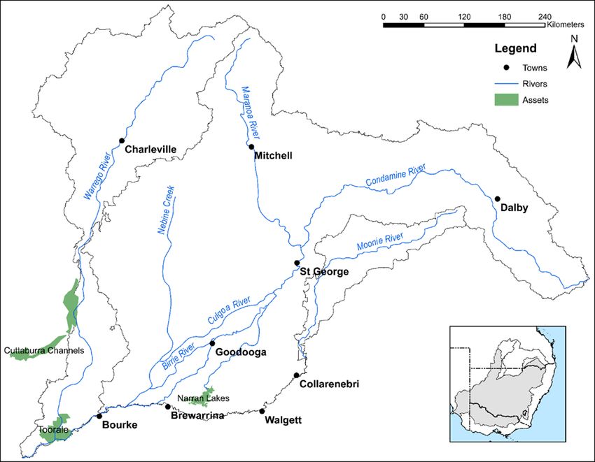
Warrego and Moonie Water Plan 2021–22

Contents
5     Warrego and Moonie Valleys Water Plan ....................................................................................... 1
      5.1          Region overview .........................................................................................................................................1
      5.2          Environmental objectives.......................................................................................................................4
      5.3          First Nations environmental watering objectives ........................................................................5
      5.4          Recent conditions and seasonal outlook ..........................................................................................5
      5.5          Water delivery in 2021–22 ................................................................................................................. 11
      5.6          Monitoring and lessons learned ....................................................................................................... 13
      References ................................................................................................................................................................ 17

Tables
Table WMV1 Environmental demands in 2021–22 for the Moonie Valley ...............................................8
Table WMV2 Environmental demands in 2021–22 for the Warrego Valley .............................................8
Table WMV3 Key lessons learned in the Warrego and Moonie Valleys ................................................... 13

Figures
Figure WMV1 Management strategy for Commonwealth environmental water at Toorale ........... 12

Maps
Map WMV1 Warrego and Moonie River Valleys ...................................................................................................4

                                           Department of Agriculture, Water and the Environment
                                                                                       iii
Warrego and Moonie Water Plan 2021–22
5 Warrego and Moonie Valleys Water
Plan
5.1 Region overview
5.1.1 River system
The Warrego and Moonie River Valleys are characterised by highly variable rainfall and
ephemeral (intermittent) stream flows (Map WMV1) (MDBA 2021a,b). Significant flow events
generally result from heavy rainfall in elevated headwater areas (CSIRO 2007,2008; DEHP 2016,
MDBA 2021a,b). No flow periods of several months are common, extending to several years
during prolonged dry conditions (CSIRO 2007, 2008; DEHP 2016, MDBA 2021a,b).
The flat landscape, low local runoff and intermittent flow conditions in both the Warrego and
Moonie Valleys have led to the evolution of distinctive ecology in lowland river reaches
(Balcombe et al. 2006). Aquatic and floodplain species are adapted to high flow variability and
‘boom and bust’ cycles (Balcombe et al. 2006). This is characterised by episodes of intense
reproduction and high productivity by opportunistic plants and animals – the boom – associated
with periods of flooding, followed by periods of stress and reduced production – the bust
(Balcombe et al. 2006).
The Warrego River is largely unregulated, other than the State-owned Allan Tannock Weir at
Cunnamulla (MDBA 2021a). Only a small volume of surface water in the Warrego catchment is
diverted for irrigation and urban use (MDBA 2021a). Some water is also taken from the river by
diversion of flow or overland flows into private off-channel storages (MDBA 2021a).
Similar to the Warrego, the Moonie River is a predominantly unregulated system and has no
major water storages. A weir was built over the river at Thallon in 1959 to supply town water
(MDBA 2021b). Almost all irrigation in the Moonie depends on surface water. However, these
diversions are small compared to overall surface water available (CSIRO 2008).
5.1.2 Traditional Owners
The lands and waters of the Warrego and Moonie Valleys hold significant spiritual and cultural
importance for Aboriginal people. Many Aboriginal nations retain a connection with the two
regions and their history, culture and livelihoods are closely intertwined with their river
systems. The Commonwealth Environmental Water Office (CEWO) respectfully acknowledges
these Nations, their Elders past and present, as the Traditional Custodians of the lands on which
this chapter is focused.
The Warrego Valley takes in (or closely borders) the traditional lands of the
Yuwaalaraay/Euahlayi, Bidjara, Gwamu/Kooma, Gunggari/Kungari, Kunja, Mandandanji,
Mardigan, Githabul and Murrawarri nations (MDBA 2021a).
The Moonie catchment includes the traditional lands of the Bigambul, Gomeroi/Kamilaroi and
Mandandanji nations (MDBA 2021b).
Department of Agriculture, Water and the Environment
1Warrego and Moonie Water Plan 2021–22
5.1.3 Important sites and values
There are many environmental assets in the Warrego Valley including species and communities
of fish, waterbirds and vegetation and important habitats such as wetlands and drought refuges.
The Warrego Valley supports large areas of wetlands. The nationally significant Cuttaburra
Channels and Yantabulla Swamp (a mosaic of channels, floodways and wetlands) consistently
support large numbers and a high diversity of waterbirds and provides breeding sites for ducks
and colonial waterbirds when flooded (Kingsford et al. 1997,1999, 2013; Bino et al. 2015; NSW
DPIE 2020; MDBA 2021a). Waterholes along the Warrego River near Charleville are an
important breeding area for native fish including Murray cod and silver perch (MDBA 2021a).
Toorale’s Western Floodplain is also an ecologically important floodplain wetland, providing
important feeding and breeding habitat for a range of water dependent species in wet conditions
(ELA 2019; NSW DPIE 2020; UNE & 2 Rog Consulting 2020a,b, 2021).
These ecological populations and habitats are connected to the Barwon–Darling River, providing
a critical drought refuge and movement corridor for fish and waterbirds (NSW DPIE 2020).
Native vegetation in the Warrego Valley includes important riparian and floodplain communities
such as lignum, river red gum, river cooba, black box and coolabah (NSW DPIE 2020). There is a
high proportion of remnant vegetation in good condition in some areas including the floodplains
of the Warrego, such as stands of coolibah, black box and lignum (NSW DPIE 2020). The Western
Floodplain also supports ‘tiny teeth’ (Dentella minutissima) a plant species listed as threatened
under NSW legislation (NSW DPIE 2020).
In between boom periods, channels in the Warrego typically dry to a series of disconnected
waterholes, which are drought refuges that are reconnected by the next significant flow event
(Marshall & Lobegeiger 2020). Semi-permanent and permanent waterholes in the main river
channels and distributary creeks and anabranch systems are critical to ensuring the survival of
species between boom periods and their capacity to recolonise the system in subsequent flow
periods (Marshall & Lobegeiger 2020). Much of the riverine fauna (e.g. fish, turtles,
invertebrates) of the Warrego Valley is dependent upon the persistence of a network of refugial
waterholes during frequent and often prolonged no flow periods (NSW DPIE 2020; Marshall &
Lobegeiger 2020).
The Warrego and Moonie Valleys support several species listed as endangered or vulnerable
under the Environment Protection and Biodiversity Conservation Act 1999. These include Murray
cod, silver perch, Australian painted snipe, Australasian bittern, and examples of the threatened
ecological community of coolibah-blackbox woodland (NSW DPIE 2020).
Over 100 wetlands exceeding one hectare in area have been mapped in the Moonie, many of
which are in the lower catchment below Nindigully (CSIRO 2008; DES 2018). Thallon waterholes
have been observed to support between 10,000 and 20,000 waterbirds (Kingsford et al. 1997).
There is past evidence of black swans, grey teal and little black cormorants breeding at the
waterholes (DNR 1999). Banded lapwing and wandering whistling-duck have also occurred in
high abundance (Bino et al. 2015; DES 2018).
The Moonie flows through the endangered southern Brigalow belt, which contains remnants of
Brigalow forests, poplar box, Wilga and white cypress pine (DES 2018).
Department of Agriculture, Water and the Environment
2Warrego and Moonie Water Plan 2021–22
The Moonie has relatively long and deep waterholes that have been shown to be critical refugia
for sustaining native fish populations in the often long periods between flows in the system.
Waterhole habitat has been identified in three main spatial areas in the Moonie: upstream of
Flinton, downstream of the confluence of the Moonie River and Teelba and Bidgel creeks, and
within the Nindigully floodplain assessment reach (DES 2018). Species including golden perch,
bony bream, eel tailed catfish and smelt moved significant distances (up to 70 kilometres) in
response to waterhole reconnecting flows, enabling recolonisation of the system and genetic
mixing (Marshall et al. 2016). Native fish species recorded in the Moonie include the threatened
silver perch and freshwater catfish as well as the environmentally, socially and economically
important golden perch (DRNME 2018).
5.1.4 Stakeholder engagement
In the Warrego and Moonie Valleys, planning, management, and delivery of Commonwealth
water for the environment is undertaken in conjunction with a range of partners and
stakeholder groups. Key stakeholders in the Warrego Valley include the Queensland
Departments of Regional Development, Manufacturing and Water (DRDMW), Environment and
Science (DES), and Agriculture and Fisheries (DAF), NSW Department of Planning, Industry and
Environment (DPIE), NSW Department of Primary Industries (DPI) – Fisheries, NSW National
Parks and Wildlife Service (NPWS) and the Toorale Joint Management Committee.
Local Engagement Officers from the Commonwealth Environmental Water Office (CEWO) also
work with different stakeholders as part a broader program of engagement around the
management of the Commonwealth’s portfolio of environmental water entitlements. As part of
this work, the CEWO’s Local Engagement Officers have been engaging directly with members of
the local Aboriginal community. This work has focused on aligning priorities for water use with
Aboriginal community objectives for sites, values and species significant to all Nations in the
Warrego and Moonie Valleys.
Department of Agriculture, Water and the Environment
3Warrego and Moonie Water Plan 2021–22
Map WMV1 Warrego and Moonie River Valleys
Source: Department of Agriculture, Water and the Environment (n.d.)
5.2 Environmental objectives
Based on long-term environmental objectives in the Basin Plan, state long-term watering plans,
site management plans, and best available knowledge, the following objectives are relevant for
environmental watering in the Warrego Valley. These objectives will continue to be revised as
part of the CEWO’s commitment to adaptive management.
• Vegetation – Maintain and improve the condition, growth and survival of riparian, in-
channel, floodplain and wetland vegetation.
• Waterbirds – Maintain foraging, roosting and breeding habitats at targeted sites on the
floodplain to support waterbirds.
• Native fish – Improve habitat condition, and support different life stages (migration,
spawning, recruitment and refuge), natural flow variability, and connectivity between river
channels, wetlands, anabranches and floodplains.
• Invertebrates – Maintain and improve the micro- and macro-invertebrate communities by
providing a variety of habitat and flow conditions.
• Other vertebrates – Support survival and recruitment of other native aquatic species,
including frogs and turtles.
• Connectivity – Support longitudinal connectivity, including with the Barwon River, and
lateral connectivity between the river(s), wetlands and floodplain.
Department of Agriculture, Water and the Environment
4Warrego and Moonie Water Plan 2021–22
• Processes/water quality/resilience – Support key ecosystem functions, biotic dispersal, and
promote productivity; maintain water quality in channels and pools; and maintain drought
refuge habitat.
5.3 First Nations environmental watering objectives
The CEWO is committed to working with First Nations groups to better understand their
objectives. The CEWO will use environmental flows to contribute to these objectives where
possible and where this is consistent with the Commonwealth Environmental Water Holder’s
statutory responsibility of protecting and restoring environmental assets in the Basin (see
Chapter 2).
As the next steps, the CEWO will develop and implement a work program to work with First
Nations groups in the northern Basin. This work program will be developed in collaboration
with First Nations groups and will be integral in continuing to build relationships and our
capacity with First Nations groups. It will also ensure First Nations groups actively participate in
the planning and management of environmental flows.
5.4 Recent conditions and seasonal outlook
5.4.1 Recent conditions and environmental water use
During the first half of the 2020–21 water year, the Moonie catchment experienced largely
average to drier than average rainfall conditions and warmer than average temperatures (BOM
2021f-k). Wetter conditions occurred in summer and autumn 2020–21, particularly in January
to March 2021 (BOM 20211f-k). There was around 450 mm of rainfall recorded at the Flinton
gauge in the upper Moonie catchment in 2020–21 (with minimal rainfall in April and May 2021),
and around 400 millimetres of rainfall at the Nindigully gauge over the same period (DRDMW
2021b). There were flood warnings issued for the Moonie river at Flinton and Nindigully in
January-April 2021.
The Commonwealth’s unregulated Queensland licenses in the Moonie were triggered in January
through to April 2021, with an estimated total contribution of around 5.7 gigalitre and all licence
volumes exhausted by mid April 2021. Around 114 gigalitres flowed past the most downstream
gauge at Gundablouie from 1 January 2021 to the end of May 2021, contributing an estimated
100 gigalitres of inflows to the Barwon-Darling (WaterNSW 2021c).
There was periodic rainfall across the Warrego Valley throughout the water year (BOM 2021a).
Most rainfall occurred in March 2021 with the upper and lower Warrego catchment receiving
100 to 200 mm and central areas around Charleville, Wyandra and Cunnamulla receiving up to
100 mm (BOM 2021b,c).
Unregulated licences in the Queensland portion of the Warrego Valley were triggered in March
and April 2021, with an estimated environmental contribution of 5.2 gigalitres in the Lower
Queensland Warrego (gauged at Cunnamulla weir) and 198 megalitres in the upper Warrego
(gauged at Augathella).
Commonwealth environmental water in combination with natural flows entered the nationally
significant Cuttaburra and Yantabulla wetland areas downstream of Cunnamulla, with around
27 gigalitres flowing past the Turra gauge (WaterNSW 2021a). This was a much smaller event
Department of Agriculture, Water and the Environment
5Warrego and Moonie Water Plan 2021–22
compared to 2019–20, for example around 95 gigalitres total volume past the Cunnamulla gauge
in 2020–21, compared to around 1,000 gigalitres in 2019–20 (DRDMW 2021a).
The Commonwealth’s Toorale licences on the Warrego River were not activated in 2020–21, as
the multi-year account limit was reached last year. The high flow licence at Toorale was also not
triggered in 2020–21. Around five gigalitres flowed from the Warrego River into the Darling
River between March and April 2021, helping meet downstream environmental demands
(WaterNSW 2021b). While the Western Floodplain at and around Toorale National Park
received local rainfall in March 2021, there was no flow from the Warrego River onto the
Western Floodplain in 2020–21 (Paul Frazier [2 Rog Consulting] 2021, pers. comm. 11 May).
Native fish in the upper Warrego have responded well to flows over the last two years, with
refuge pools near Charleville supporting abundant golden perch and some Murray cod, with a
relatively low carp presence (Marshall & Lobegeiger 2020). Waterbirds in the Cuttaburra and
Yantabulla area have also benefited from flows to the area (Kingsford & Wainwright 2020;
Thorburn 2020).
Vegetation on the Western Floodplain at Toorale near the junction of the Warrego and Darling
rivers dried back during the first half of 2020–21, with lignum showing a decrease in condition
(UNE & 2 Rog Consulting 2020b). However, plant height and size increased, showing longer term
benefits of flows to the area (UNE & 2 Rog Consulting 2020b).
Drier conditions in the first half of 2020–21 may have confined native fish to refuge pools along
the system (UNE & 2 Rog Consulting 2020b). However, the flow events in March and April 2021
improved conditions for golden perch and other native fish species, and would likely have
provided spawning and recruitment opportunities and connectivity with the Barwon-Darling
river system (UNE & 2 Rog Consulting 2021).
A return to dry conditions before flows in early 2021 also limited the abundance and diversity of
waterbirds and frogs, although the longer-term productivity and food web benefits of flows are
apparent in resident bird species including sea eagles (UNE & 2 Rog Consulting 2020b). These
species are expected to respond positively to the most recent flows. Yabbies and turtles are also
doing well in the Toorale area, showing the benefits of both environmental water and natural
flows (UNE & 2 Rog Consulting, 2021).
Learn more about Learn more about previous Commonwealth environmental water use in the
Warrego and Moonie valleys.
5.4.2 Seasonal outlook
According to the Bureau of Meteorology’s outlook issued on 3 June 2021, there is some chance of
above average rainfall across the Warrego and Moonie Valleys from June to September 2021
(BOM 2021c). Maximum temperatures are also forecast to remain average or above average
over the coming months (BOM 2021d,e).
This forecast suggests weather patterns may further improve the condition of rivers and
wetlands across the Warrego and Moonie Valleys (and other Northern Basin systems). However,
it is also possible that dry conditions may re-eventuate over coming months, which would
hinder recovery.
Department of Agriculture, Water and the Environment
6Warrego and Moonie Water Plan 2021–22
5.4.3 Water availability
The Warrego and Moonie Valleys have fewer regulating structures than other areas of the
Murray–Darling Basin, which limits options for the managed delivery of water for the
environment at a predetermined volume and time. Instead, Commonwealth water for the
environment in these two river systems can generally only be sourced as a share of an
unregulated flow event or in some cases targeted management within an event. Most
Commonwealth unregulated entitlements are left in-stream to provide environmental benefits
by restoring flows that were formerly extracted, which improves flow variability.
Water availability depends on the flow events that occur. Unregulated entitlements provide
opportunistic access to river flows when water levels exceed trigger values at certain locations,
as specified in entitlement conditions. Each triggered Commonwealth environmental water
entitlement leaves water in the river which could otherwise be extracted. This makes a
contribution to restoring natural flows, reflecting its particular flow access windows, take rates
and location. Daily, instantaneous, annual or multi-year limits cap overall diversions in any given
year or flow event, and likewise the in-stream contributions that can be attributed to
unregulated Commonwealth entitlements.
There is some capacity to direct flows at the junction of the Warrego and Darling rivers through
infrastructure on the Toorale site (managed by the NSW National Parks and Wildlife Service in
consultation with the Toorale Joint Management Committee). However, this is limited by the
nature of the Commonwealth’s entitlements in the Warrego and Darling rivers and day to day
operations of the Toorale infrastructure. Upgrades and changed management of the Toorale
structures is underway through the Toorale Infrastructure Project (NSW DPIE 2021).
5.4.4 Environmental demands
For the environmental water demands for assets in the Warrego and Moonie Valleys in 2021–22,
see Table WMV1 (Moonie Valley) and Table WMV2 (Warrego Valley). The capacity to contribute
to these environmental demands is contingent on the Commonwealth licences being triggered
by natural flow events.
Department of Agriculture, Water and the Environment
7Warrego and Moonie Water Plan 2021–22
Table WMV1 Environmental demands in 2021–22 for the Moonie Valley
Indicative demand (for all sources of water in the system) Environmental
demands for water
Environmental assets Target values Flow/volume Required frequency Watering history (from all sources of water)
(all sources) in
(maximum dry interval) 2021-22
Moonie River (at Native fish dispersal and Very low flow (VLF) (>30 ML/day) Timing in line with At least 96% of years. Met in all years since 2010–11 excluding 2018–19. Required annually therefore a high demand for water in
Gundablouie) condition natural (anytime). (Max. interval 70 days (but not 2021–22, remaining high in 2022–23 if watering occurs.
High
Native fish spawning and Minimum duration: typically 60 days/year exceed VLF more than 283 days))
recruitment threshold but not less than nine days/yr.
Native vegetation Small fresh 1: >300 ML/day any time (ideally October to 3 to 8 years in 10 (55%). Met or partially met in seven of the last ten years, including in 2019–20 and 2020-21. Low environmental
Aquatic ecosystem April). Minimum duration ten days (Max. interval four and a half demand in 2021–22, remaining low in 2022–23 if watering occurs. Low
function years)
Small fresh 2: >314 ML/day (September to April) 1 to 5 years in 10 (30%) Met or partially met in six of the last 10 years, including in 2019–20 and 2020–21. Low environmental demand in
Minimum duration 14 days 2021–22, remaining low in 2022–23 if watering occurs. Low
(Max. interval seven years)
Large fresh 1: >3,900 ML/day (any time) duration five 2 to 6 years in 10 (45%). Met or partially met in six of the last 10 years, including being partially met in 2019-20 and fully met in 2020–21.
days Low environmental demand in 2021–22, remaining low in 2022–23 if watering occurs. Low
(Max. interval 6.5 years)
Large fresh 2: >3,900 ML/day (October to April) 2 to 5 years in 10 (35%) (Max Met or partially met in six of the past 10 years, including being partially met in 2019–20 and met in 2020–21.
duration five days. interval 6.5 years) Low environmental demand in 2021–22, remaining low in 2022–23 if watering occurs. Low
Large fresh 3: 5,100–18,800 ML/day (any time) duration 2 to 7 years in 10 (45%). Met or partially met in five of the last 10 years, including in 2020–21. Moderate environmental demand in 2021–
three days 22, moving to low in 2022–23 if watering occurs. Moderate
(Max. interval 5 years)
Overbank: >18,800 ML/day (any time) duration three 0 to 3 years in 10 (10%). Met in three years in the last 10 years, but not met since 2013–14. High environmental demand, moving to
days. moderate in 2022–23 if watering occurs. High
(Max. interval 20 years)
Note: All watering history sourced from NSW Department of Planning, Industry and Environment, WaterNSW Water Balance Reports, and data from the following gauge (WaterNSW 2021a): 417001 – Moonie River at Gundablouie.
Key
Environmental demands (demand is considered at a generalised scale; there may be specific requirements that are more or less urgent within the flow regime)
High to critical demand for water (needed in that particular year or urgent in that particular year to manage risk of irretrievable loss or damage)
Moderate demand for water (water needed in that particular year, the next year, or both)
Low demand for water (water generally not needed in that particular year)
Table WMV2 Environmental demands in 2021–22 for the Warrego Valley
Indicative demand (for all sources of water in the Environmental
system) demands for water
Environmental (all sources) in
Target values Flow/volume Required Watering history (from all sources of water) 2021-22
assets frequency
(maximum dry
interval)
Cuttaburra Native fish Small fresh 1:Warrego and Moonie Water Plan 2021–22
Indicative demand (for all sources of water in the Environmental
system) demands for water
Environmental (all sources) in
Target values Flow/volume Required Watering history (from all sources of water) 2021-22
assets frequency
(maximum dry
interval)
Native fish Small fresh 2: 220 to 2,200 ML/day 5 to 10 years in Met or partially met in 9 out of the last 10 years, including 2019–20 and 2020–21. Low environmental demand in 2021–22, remaining low in 2022–23 if watering
spawning and (September to April) for 14 days 10 (75% of occurs.
recruitment (spawning of in–channel specialists and years).
Low
Native vegetation generalists) (Maximum dry
Support refuge interval five
habitat (frogs, fish, years)
waterbirds) Large fresh 1: >2,200 ML/day any time 5 to 10 years in Met or partially met in 6 out of the last 10 years, including being fully met in 2019–20 and partly met in 2020–21. Moderate demand in 2021–22, remaining
Aquatic ecosystem for 5 days 10 (75% of moderate in 2022–23 if watering occurs.
function years)
Moderate
(Maximum dry
interval four
years)
Large fresh 2: >2,200 ML/day (October 4 to 5 years in Met or partially met in 6 out of the last 10 years, including being fully met in 2019–20 and partially met in 2020–21 (duration not met). Therefore there is a low
to April) for 5 days 10 (40%) demand in 2021–22, remaining low in 2022–23 if watering occurs.
(Maximum dry Low
interval five
years)
Overbank flows: >5,400 ML/day any 4 to 5 years in Met in 4 out of the last 10 years, including 2019–20 but not met in 2020–21. Moderate demand in 2021–22 reducing to low in 2022–23 if watering occurs.
time for 2 days 10
(Maximum dry Moderate
interval nine
years)
Warrego River Refuge habitat Flows to replenish refuges and connect Annually Met every year except 2012–13. Required annually, therefore high demand in 2021–22, remaining high in 2022–23 if watering occurs.
(Boera Dam to (waterbirds, frogs, to the Darling River. (Maximum dry
Darling) fish) interval one High
Instream aquatic year)
ecosystems
Riparian vegetation In-channel flows: Up to 600 ML/day for Ideally: 5 to 10 Met every year except 2012–13. Moderate environmental demand in 2021–22, moving to low in 2022–23 if watering occurs.
In-stream aquatic minimum 10 days to enable fish in 10 years
ecosystems passage and movement (Maximum dry
Moderate
Fish connectivity interval two
and movement years)
Riparian vegetation
Toorale Wetland and Wetland inundating flow(WL1) Minor Preferably: 1 to Met in 5 out of the last 10 years, including 2018–19 and 2019–20. Not met in 2020–21. Cumulative volume past Fords Bridge combined between 3 April and 3
Western floodplain inundation: Cumulative volume 7,000 1.5 years May 2021 was almost 12 gigalitres, however all of this water was passed through Boera Dam, meaning minimal wetland inundation occurred (Paul Frazier [2 Rog
Floodplain vegetation ML past Fords Bridge (combined) over (lignum); One to Consulting] 2021, pers. comm. 11 May). High environmental demand in 2021–22, moving to moderate in 2022–23 if watering occurs.
Threatened species 30 days (anytime). Minor inundation to three years
(Atriplex inundate vegetation such as lignum, (river cooba,
infrequens, coolibah, river cooba, chenopod, forbs. river red gum,
Dentella Northern and Central parts of the black box);
High
minutissima, and floodplain 7 to 15 years
Osteocarpum (2,420 ha) (Coolibah).
scleropterum) and 5 to 10 years in
ecological 10
communities such
(Maximum dry
as coolibah-
interval 2 years)
blackbox woodland
Migratory birds Wetland inundating flow (WL2) – half Anytime Met or partially met in five out of the last 10 years, including in 2018–19 and 2019–20. Not met in 2020–21. Moderate environmental demand in 2021–22.
(e.g. Eastern great inundation: Cumulative volume 16,000 Ideally: 4 to 8 in
egret; glossy ibis; ML past Fords Bridge combined over 10 years
oriental pranticole; 30 days.
(Maximum dry
rainbow bee-eater) Inundation of around half the Moderate
interval 3 years)
Native fish nursery floodplain to inundate vegetation such
and frog habitat as lignum, coolibah, river cooba,
chenopod, forbs.
(4,459 ha)
Department of Agriculture, Water and the Environment
9Warrego and Moonie Water Plan 2021–22
Indicative demand (for all sources of water in the Environmental
system) demands for water
Environmental (all sources) in
Target values Flow/volume Required Watering history (from all sources of water) 2021-22
assets frequency
(maximum dry
interval)
Wetland inundating flow (WL3) – full Any time Met in 3 out of the last 10 years, including in 2019–20. Not met in 2020–21. Moderate environmental demand in 2021–22.
inundation: Cumulative volume of Ideally: 3 to 6
33,000 ML past Fords Bridge combined years in 10
over 30 days. Inundation of around the
(Maximum dry Moderate
full floodplain to inundate vegetation
interval six
such as lignum, coolibah, river cooba,
years)
chenopod, forbs.
(7,104 ha)
Boom inundation of more than entire Any time Met in two of the last 10 years, including in 2019–20, not met in 2020–21. Low environmental demand in 2021–22.
Western Floodplain, Uteara lake, Ideally: 1 to 3
reconnections to Darling and return years in 10
flows to the Warrego. Darling may
(Maximum dry
backup to provide greater inundation.
interval 10 Low
(11,847 ha) years)
75,000 ML/year to the Western
Floodplain to inundate vegetation such
as lignum, coolibah, river cooba,
chenopod and forbs.
Darling River Native fish habitat, Darling River is considered a priority Annually Refer to Barwon–Darling Plan 2021–22 for a detailed watering history. As of 27 May 2021 nearly 1,255 GL had passed the Louth gauge with flows receding to a
(downstream movement, refuge (above all other priorities) when rate of 1,619 ML/day. Therefore this demand has been assessed as moderate in 2021–22, remaining moderate in 2022–23 if watering occurs.
of the junction and spawning conditions in the Darling River at Louth
with the In–stream aquatic exceed one or more environmental
Warrego) ecosystems and water requirements from the Barwon
riparian vegetation Darling Long -Term Water Plan:
Provides When cease to flow conditions have
connectivity and occurred for more than 110 days;
movement There has been more than 135 days of
between Darling flow less than 450 ML/day, or; Moderate
and Warrego It has been more than one year since a
catchments small fresh of at least 1,500 ML/day
Support refuge occurred for at least 10 days as
habitat measures at the Louth gauge.
Frog and waterbird
habitat and refuge
Improve water
quality
Note: All watering history sourced from NSW Department of Planning, Industry and Environment and Queensland partner agencies, WaterNSW Water Balance Reports, and data from the following gauges (WaterNSW 2021a and DRDMW 2021a,b): 423005 – Cuttaburra Channel at Turra, 423004 – Warrego
River at Barringun, 423001 Warrego River at Fords Bridge, 423002 Warrego River at Fords Bridge Bywash and 425004 – Darling River at Louth.
Key
Environmental demands (demand is considered at a generalised scale; there may be specific requirements that are more or less urgent within the flow regime)
High to critical demand for water (needed in that particular year or urgent in that particular year to manage risk of irretrievable loss or damage)
Moderate demand for water (water needed in that particular year, the next year, or both)
Low demand for water (water generally not needed in that particular year)
Department of Agriculture, Water and the Environment
10Warrego and Moonie Water Plan 2021–22
5.5 Water delivery in 2021–22
Commonwealth environmental water entitlements in the Warrego and Moonie are unregulated
(or ‘unsupplemented’ in the Queensland portion of each Valley) and are left instream to
contribute to environmental outcomes. In 2021-22, the volumes of Commonwealth
environmental water that reach the NSW border will be recorded by Queensland DRDMW on a
daily basis. It is expected that the portion of these flows that reaches the Barwon-Darling River
will then be protected from extraction by WaterNSW using active management.
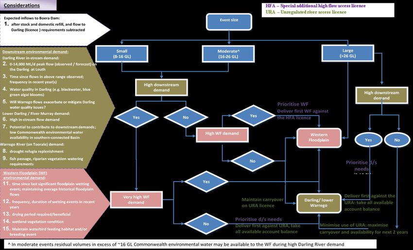
The Commonwealth’s unregulated holdings on the Warrego River at Toorale are managed in
accordance with the management strategy for use of these licences at Boera Dam (Figure
WMV1) to meet environmental demands outlined in Table WMV2. The CEWO will have access to
the Toorale Warrego River licences in 2021–22. Operation of the Toorale infrastructure will
continue to be managed by the NSW National Parks and Wildlife Service and DPIE, in
consultation with the Toorale Joint Management Committee and the CEWO. The management
strategy will be revised in 2022 upon completion of the Toorale Water Infrastructure project
(NSW DPIE 2021).
Further information on environmental demands in the Barwon–Darling is provided in the CEWO
Water Management Plan 2021–22: Chapter 9 Barwon–Darling.
Department of Agriculture, Water and the Environment
11Warrego and Moonie Water Plan 2021–22
Figure WMV1 Management strategy for Commonwealth environmental water at Toorale
Department of Agriculture, Water and the Environment
12Warrego Valley Water Plan 2021–22
5.6 Monitoring and lessons learned
5.6.1 Monitoring
Operational monitoring is undertaken for all Commonwealth environmental watering actions
and involves collecting on-ground data about Commonwealth environmental watering such as
volumes used, impact on the river systems hydrograph, area of inundation and river levels. It
can also include observations of environmental outcomes.
In the Warrego Valley, the five-year Long-Term Intervention Monitoring (LTIM) Project (2013–
2014 to 2018–19) included the junction of the Warrego and Darling Rivers as a focus area. It
aimed to understand the environmental response from Commonwealth environmental watering
with respect to the targeted objectives by carrying out monitoring of site condition over many
years.
This monitoring is being continued under the CEWO Monitoring, Evaluation and Research three-
year program from 2019–20 to mid-2022.
The CEWO has also co-funded a short-term intervention monitoring project with Queensland
DES to better understand native fish resilience following severe drought in the Northern
Murray-Darling Basin, including the upper Warrego. Results from this project will be available in
early 2022. The CEWO does not currently fund any monitoring in the Moonie Valley.
Learn more about monitoring and research funded by the CEWO in the Warrego and Moonie
Valleys.
5.6.2 Lessons learned
Outcomes from monitoring and lessons learned in previous years are a critical component for
the effective and efficient use of Commonwealth water for the environment. These learnings are
incorporated into the way environmental water is managed.
Key findings from fish, aquatic habitat and flow monitoring in the Warrego and Moonie Valleys
are summarised in Table WMV3.
Table WMV3 Key lessons learned in the Warrego and Moonie Valleys
Theme Lessons learned
Native fish and • Flows in the Warrego River, including environmental water, support breeding and
aquatic recruitment of many fish species. During ‘wetter’ times, multiple species have been
invertebrates observed to breed, recruit and maintain their population structure, e.g. golden
perch, spangled perch, bony herring, Hyrtl’s tandan (ELA 2019; UNE & 2 Rog
Consulting 2020a; Marshall & Lobegeiger 2021).
• Golden perch spawn on river rises in the Warrego River, and recruits from within
this river system are likely to be contributing to the wider Murray–Darling Basin
golden perch population (UNE & 2 Rog Consulting 2020a). The upper Warrego
River supports a strong golden perch population, supported by natural spawning
and recruitment events. Murray cod are also present in the upper Warrego River,
with relatively low carp presence (Marshall & Lobegeiger 2020).
• The fish community in the Warrego River are highly resilient and can survive highly
variable flow conditions, including drying down. Fish communities were able to
recolonise and recruit following larger flow events. Golden perch, spangled perch
and bony herring have demonstrated an ability to move, colonise and
opportunistically recruit in the Warrego River in response to increased flows (ELA
2019; Marshall & Lobegeiger 2021).
Department of Agriculture, Water and the Environment
13Warrego Valley Water Plan 2021–22
Theme Lessons learned
• Retaining water at all times in at least some of the five main waterholes on the
Warrego River will ensure that when the system is reconnected, there are
populations present that can distribute and recolonise across the lower sections of
the Warrego. This helps prepare native fish populations for the next drying phase
(ELA 2019; Marshall & Lobegeiger 2021).
• The Moonie has relatively long and deep waterholes that have been shown to be
critical refugia for sustaining native fish populations in the often-long periods
between flows in the system. Species including golden perch, bony bream, eel tailed
catfish and smelt moved significant distances (up to 70 kilometres) in response to
waterhole reconnecting flows, enabling recolonisation of the system and genetic
mixing (Marshall et al. 2016).
• The Moonie has also been identified as a source population for golden perch in the
Northern Murray–Darling Basin (along with the Condamine–Balonne and Border
Rivers) with consistent recruitment over the past decade (Price et al. 2019; Greg
Ringwood [Murray–Darling Basin Authority] 2021, pers. comm., 20 May).
Waterbirds • In the Queensland Warrego River, the Cuttaburra channels represent 10%
abundance of each species (one of only four wetlands in the Murray–Darling Basin,
with the others being the Lowbidgee, Lower Coorong and Thallon wetlands). The
Cuttaburra has been identified as important for waterbirds at a whole-of-Basin
scale during wet times (Bino et al. 2015).
• Surveys in March 2021 found waterbirds at all sites at Toorale, with the highest
bird count at Boera Dam and lower waterbird numbers on the Western Floodplain
(UNE & 2 Rog Consulting 2021). Birds detected at Boera included brolgas and the
listed migratory species sharp-tailed sandpiper (UNE & 2 Rog Consulting, 2021).
Sea eagles were also recorded breeding at Boera Dam in early 2021, unusual in an
inland area (UNE & 2 Rog Consulting 2021).
• While not recognised as nationally or internationally significant, the Thallon
waterholes on the Moonie are important for waterbirds, with representation of
10% abundance for each species between 1983–2012 (only four other wetlands
achieved this including the Cuttaburra channels, Lowbidgee and Lower Coorong)
(Bino et al. 2015).
• Waterbirds tracked by CSIRO Land & Water have been recorded visiting the Moonie
Valley in 2020–21 including straw-necked ibis ‘Elf’ and ‘Dani’ (CSIRO 2021).
Connectivity • Environmental water has been observed to successfully increase longitudinal
connectivity between the Warrego and Darling rivers, and laterally, with parts of
the Western Floodplain (ELA 2019). By increasing connectivity, water for the
environment improves water quality, increases available habitat and productivity,
and supports native fish movement between rivers (ELA 2019). The resulting
productivity booms can also generate an increase in the abundance and diversity of
invertebrates, frogs and waterbirds on the floodplain (ELA 2019).
• Environmental water can successfully increase the size of flows through the
Warrego system, increasing connectivity between the Warrego and Darling rivers
(ELA 2019). This is important for improving water quality, increasing productivity
and allowing the movement of native fish between rivers for spawning, dispersal
and recruitment (ELA 2019). Around 5 gigalitres of water from the Warrego is
estimated to have contributed to flows in the downstream Darling in 2020–21
(WaterNSW 2021b).
• The Moonie can provide important tributary inflows to the Barwon–Darling during
unregulated flow events (around 100 gigalitres in 2020–21) (WaterNSW 2021d).
While the Commonwealth’s environmental water entitlements in the Moonie are a
relatively small proportion of these natural flows, better cross-border accounting
arrangements being worked out between Queensland and NSW with input from the
Commonwealth will help us track environmental water from the Queensland
Moonie into the NSW catchment and downstream to the Barwon–Darling. Active
management arrangements in NSW will also provide better protection of the
Commonwealth’s environmental water in the Moonie and other unregulated
Barwon–Darling tributaries.
Water quality • Water for the environment delivered through the Warrego River consistently helps
improve the quality of Darling River water downstream of the confluence (ELA
2019; UNE & 2 Rog Consulting 2020a). Observed improvements include reduced
Department of Agriculture, Water and the Environment
14Warrego Valley Water Plan 2021–22
Theme Lessons learned
pH, conductivity, turbidity and algal productivity, and increased nutrient cycling
and habitat when compared with periods without environmental water (ELA 2019;
UNE & 2 Rog Consulting 2020a).
Food webs/ • Environmental water that contributes to connection with the floodplain for a long
productivity duration (more than six months) stimulates a boom in productivity, which provides
food for higher order predators such as waterbirds (ELA 2019; UNE & 2 Rog
Consulting 2020a).
• The Western Floodplain is important for highly dense and species rich invertebrate
communities. More diverse macroinvertebrate communities may offer a wider
range of feeding opportunities for higher level consumers such as frogs, fish,
waterbirds and other aquatic vertebrates (ELA 2019; UNE & 2 Rog Consulting
2020a).
• The Warrego and Western Floodplain are productive systems, species such as
shrimps and tadpoles responded quickly to inundation (ELA 2019, UNE & 2 Rog
consulting 2020a). Species such as fairy and shield shrimps are known to rely on an
egg bank that is desiccation resistant, which may help survival and responsiveness
(ELA 2019; UNE & 2 Rog Consulting 2020a; UNE & 2 Rog Consulting 2021).
Vegetation • The condition of vegetation communities on the Western Floodplain is driven by
inundation, which has been enhanced by Commonwealth environmental water
(ELA 2019; UNE & 2 Rog Consulting 2020a). Flooding of the Western Floodplain
increased the cover and richness of vegetation communities, including annual
herbaceous ground cover species (ELA 2019; UNE & 2 Rog Consulting 2020a).
Vegetation surveys in early 2021 found groundcover percentage remained low, but
most sites had groundcover persistence and relatively high diversity (UNE & 2 Rog
Consulting 2021). Floodplain trees were looking healthy in February 2021, with a
number of mature river cooba in flower observed along the Western Floodplain
(UNE & 2 Rog Consulting 2021).
• Lignum condition improved when inundated more frequently. Extended dry
periods (greater than two and a half years) on the floodplain resulted in declines in
vegetation cover and condition (ELA 2019; UNE & 2 Rog Consulting 2020a),
However, lignum condition improved again in response to inundation in 2019 and
early 2020 (ELA 2019; UNE & 2 Rog Consulting 2020a). Monitoring of lignum in
early 2021 suggested that plant condition decreased as the area dried back
following the 2020 flows, however average height and size of plants increased (UNE
& 2 Rog Consulting 2021).
• Grazing and competition for resources are likely to impact on tree recruitment
more than inundation alone (ELA 2019; UNE & 2 Rog Consulting 2020a).
Refuges • Around 8% of river channels in the Warrego River are estimated as remaining ‘wet’
during the peak drought of 2018–2020 (Marshall & Lobegeiger 2020). In relation to
loss of connectivity, much of the upper Warrego is classed as at ‘extreme risk’
(100% loss of connectivity flows), with much of the lower part of the catchment at
high risk (>70% risk of loss of connectivity flows). Reconnection of these refuge
habitats following flows in 2020 and 2021 is likely to allow for movement of native
fish (Marshall & Lobegeiger 2020).
• Warrego River waterholes act as longer-term refuges for native fish, waterbirds,
turtles and frogs (ELA 2019; UNE & 2 Rog Consulting 2020a). Boera and Booka
dams provide the most persistent refuges. Environmental water can help replenish
and re-connect refuge habitat in the Warrego River and the Darling River near
Toorale (ELA 2019; UNE & 2 Rog Consulting 2020a).
• The Moonie river has around 8.8% of refuge waterholes that remain wet even
during peak drought (for example 2018–2020). This is considerably less than the
Border Rivers (at 22%, but more than catchments further west (Warrego and
Paroo) (Marshall & Lobegeiger 2020).
• Of the 7.6 square kilometres of waterhole habitat that exists in the Moonie River
three months after flow (McGregor et al., 2018), only 5% persisted in January 2020
at the peak of the drought, representing 95% habitat loss (Marshall & Lobegeiger
2020).
Department of Agriculture, Water and the Environment
15Warrego Valley Water Plan 2021–22
Theme Lessons learned
Other aquatic • Surveys in March 2021 found frogs across all sites in the Warrego Selected Area,
animals with Booka Dam having the highest count (mostly desert froglet) (UNE & 2 Rog
Consulting 2020b).
• Frog species are expected to recover further following the 2020–21 flows in the
Warrego catchment.
• Large turtles were detected in most dams at Toorale in early 2021. Some turtles
exceeded 7 kilograms in weight, which suggests that food resources were still
relatively abundant, despite the drier conditions during the first half of the water
year (UNE & 2 Rog Consulting 2020b).
Department of Agriculture, Water and the Environment
16Warrego Valley Water Plan 2021–22
References
Balcombe, S, Arthington, AA, Foster, ND, Thoms, MC, Wilson, GG & Bunn, SE 2006, Fish
assemblages of an Australian dryland river: abundance, assemblage structure and recruitment
patterns in the Warrego River, Murray-Darling Basin, Marine & Freshwater Research, vol. 57,
no.6, p.619, DOI: 10.1071/MF06025, accessed 3 June 2021.
Bino, G, Kingsford, RT & Porter, J 2015, Prioritising wetlands for waterbirds in a boom and bust
system: waterbird refugia and breeding in the Murray-Darling Basin, PLoS One, vol.10, no.7, DOI:
10.1371/journal.pone.0132682, accessed 24 May 2021.
BOM 2021a, Recent and historical rainfall maps rainfall deciles for Queensland from 1 July 2020
to 31 May 2021, Bureau of Meteorology, Canberra, accessed 3 June 2021.
——2021b, Water reporting summary – Warrego catchment 1 April 2021, Bureau of
Meteorology, Canberra, accessed 3 June 2021.
——2021c, Climate outlooks rainfall – the chance of above median rainfall for July to September
2021. Bureau of Meteorology, Canberra, accessed 3 June 2021.
——2021d, Climate outlooks temperature – the chance of above median maximum temperature
for July to September 2021. Bureau of Meteorology, Canberra, accessed 3 June 2021.
——2021e, Climate outlooks temperature – the chance of above median minimum temperature
for July to September 2021. Bureau of Meteorology, Canberra, accessed 3 June 2021.
——2021f, Recent and historical rainfall maps – rainfall deciles for Queensland for July to
September 2020, Canberra, accessed 1 June 2021.
——2021g, Six month maximum temperature deciles for Queensland for 1 July to 31 December
2020, Canberra, accessed 2 June 2021.
——2021h, Six month maximum temperature deciles for Queensland for 1 December 2020 to 31
May 2021, Canberra, accessed 2 June 2021.
——2021i, Recent and historical rainfall maps – rainfall deciles for Queensland for September to
December 2020, Canberra, accessed 1 June 2021.
——2021j , Recent and historical rainfall maps – rainfall deciles for Queensland for January to
March 2021, Canberra, accessed 1 June 2021.
——2021k ,Recent and historical rainfall maps – rainfall deciles for Queensland for March to
May 2021, Canberra, accessed 1 June 2021.
CSIRO 2021, Waterbird breeding and movements: satellite tracking current satellite tracking
2017-2021, CSIRO Australia, Canberra, accessed 1 June 2021.
——2008, Water availability in the Moonie. a report to the Australian Government from the
CSIRO Murray-Darling Basin sustainable yields project, CSIRO, Canberra, accessed 3 June 2021.
——2007, Water availability in the Warrego: a report to the Australian Government from the
CSIRO Murray-Darling Basin sustainable yields project, CSIRO, Canberra, accessed 3 June 2021.
Department of Agriculture, Water and the Environment
17Warrego Valley Water Plan 2021–22
DEHP 2016, Healthy waters management plan Warrego, Paroo, Bulloo and Nebine Basins,
Queensland Department of Environment and Heritage Protection, Brisbane, accessed 3 June
2021.
DES 2018, Review of water plan (Moonie) 2003 and resource operations plan environmental
assessment report, Queensland Department of Environment and Science, Brisbane, accessed 10
June 2021.
DRDMW 2021a, Queensland government water monitoring information portal stream flow data
Warrego Basin. Department of Regional Development, Manufacturing and Water, Brisbane.
Accessed 26 May 2021.
——2021b, Queensland government water monitoring information portal stream flow data
Moonie Basin. Department of Regional Development, Manufacturing and Water, Brisbane.
Accessed 26 May 2021
DNR 1999, Overview of Water Resources and Related Issues: The Moonie River Catchment.
Queensland Department of Natural Resources, Queensland.
DRNME 2018, Review of water plan (Border Rivers) 2003 summary of monitoring January 2018,
Queensland Department of Natural Resources, Mines and Energy, Toowoomba, accessed 10 June
2021
ELA 2019, Commonwealth Environmental Water Office long term intervention monitoring
project junction of the Warrego and Darling rivers selected area – five year evaluation report.
Eco Logical Australia and Commonwealth of Australia, Canberra, accessed 24 May 2021.
Kingsford, RT & Wainwright, P 2020, Day 3 – Bourke to Armidale, University of New South
Wales, Sydney, accessed 24 May 2021.
Kingsford, RT, Curtin, A & Porter, J 1999, Water flows on Cooper Creek in arid Australia
determine ‘boom’ and ‘bust’ periods for waterbirds, Biological Conservation, vol. 88, no.2, p.231,
DOI: 10.1016/S0006-3207(98)00098-6, accessed 9 June 2021.
Kingsford, RT, Bino, G, Porter, JL & Brandis, K 2013, Waterbird communities in the Murray-
Darling Basin (1983-2013) report to Murray-Darling Basin Authority, Murray-Darling Basin
Authority, Canberra, accessed 9 June 2021.
Kingsford, RT, Thomas, RF & Wong, PS, 1997, Significant wetlands for waterbirds in the Murray-
Darling Basin, NSW National Parks and Wildlife Service, Hurstville.
Marshall, JC & Lobegeiger, JS 2020, Fish population resilience following severe drought in the
Northern Murray-Darling Basin: progress report 1 incorporating highlights and conceptual models
from water drought mapping and flow connectivity analysis, Queensland Department of
Environment and Science, Brisbane.
——2021, Investigations into fish population resilience following severe drought in the
northern Murray-Darling Basin: progress report 2 incorporating highlights from first field
sampling, Queensland Department of Environment and Science, Brisbane.
Department of Agriculture, Water and the Environment
18Warrego Valley Water Plan 2021–22
Marshall, JC, Menke, N, Crook, DA, Lobegeiger, JS, Balcombe, SR, Huey, JA, Fawcett, JH, Bond, NR,
Starkey, AH, Sternberg, D, Linke, S & Arthington AH 2016, Go with the flow: the movement
behaviour of fish from isolated waterhole refugia during connecting flow events in an
intermittent dryland river, Freshwater Biology, vol.61, no. 8, p.1242, DOI: 10.1111/fwb.12707,
accessed 9 June 2021.
McGregor, G, Marshall, J, Lobegeiger, J, Holloway, D, Menke, N, Mayger B, Raymond, M, Joo, M,
Bowlen, J, Schulz, C & Steward A 2018, Review of water plan (Moonie) 2003 and resource
operations plan environmental assessment report January 2018, accessed 2 June 2021.
MDBA 2021a, Water management – catchments – Warrego, Murray-Darling Basin Authority,
Canberra, accessed 3 June 2021.
——2021b, Water management – catchments – Moonie Murray-Darling Basin Authority,
Canberra, accessed 3 June 2021.
NSW DPIE 2020, Intersecting Streams Long-Term Water Plan Part A and B: Draft for exhibition
Parramatta, NSW Department of Planning, Industry and Environment, Sydney, accessed 25 May
2021.
——2021, Toorale water infrastructure project, NSW Department of Planning, Industry and
Environment, Sydney, accessed 9 June 2021.
Price, A, Balcombe, S, Humphries, P, King, A & Zampatti, B 2019, Murray‒Darling Basin
environmental water knowledge and research project – fish theme research report, report
prepared for the Department of the Environment and Energy, Commonwealth Environmental
Water Office, Albury., accessed 2 June 2021.
Thorburn, K 2020, Birds of a feather (Bushtracks spring 2020), Bush Heritage Australia,
Melbourne, accessed 24 May 2021.
University of New England & 2 Rog Consulting 2020a, Junction of the Warrego and Darling rivers
selected area 2019-20 annual summary report. Commonwealth of Australia, Canberra. Accessed
24 May 2021.
University of New England & 2 Rog Consulting 2020b, Warrego-Darling rivers selected area MER
project newsletter 6 December 2020. Commonwealth of Australia, Canberra, accessed 24 May
2021.
University of New England & 2 Rog Consulting, 2021, The Warrego-Darling quarterly outcomes
newsletter for the Warrego-Darling selected area Q3 January-March 2021. Commonwealth of
Australia, Canberra.
WaterNSW 2021a, Continuous water monitoring network real-time data rivers and streams 423
– Warrego river basin. WaterNSW, Sydney. Accessed 26 May 2021.
——2021b, Operations update northern NSW rainfall event March 2021, 17 May 2021.
WaterNSW, Sydney. Accessed 24 May 2021.
——2021c, Operations update Northern NSW rainfall event 24 May 2021, WaterNSW, Sydney,
accessed 2 June 2021.
Department of Agriculture, Water and the Environment
19You can also read