Copernicus Marine Environment Monitoring Service (CMEMS) Service Evolution Strategy: R&D priorities - Version 4 November 2018 Document prepared by ...
←
→
Page content transcription
If your browser does not render page correctly, please read the page content below
Copernicus Marine
  Environment Monitoring
  Service (CMEMS) Service
     Evolution Strategy:
       R&D priorities
                 Version 4
               November 2018

Document prepared by the CMEMS Scientific and
   Technical Advisory Committee (STAC) and
    reviewed/endorsed by Mercator Ocean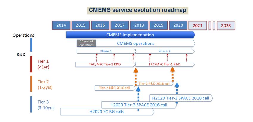
CMEMS SERVICE EVOLUTION STRATEGY: R&D PRIORITIES               June 2017                                                                                0   0

                                                       Table of content
         1      Introduction ...................................................................................................................... 1
         2      Scientific and technical backbone of CMEMS ................................................................... 3
         3      Key drivers of the Service Evolution and related R&D priorities ....................................... 4
         4      R&D areas and required developments ............................................................................ 7
             4.1 Circulation models for the global ocean, regional and shelf seas ................................... 7
             4.2 Sub-mesoscale - mesoscale interactions and processes ................................................. 8
             4.3 Coupled ocean-marine weather information, surface currents and waves .................. 10
             4.4 New generation of sea-ice modelling ............................................................................ 11
             4.5 modelling and data assimilation for marine ecosystems and biogeochemistry ........... 12
             4.6 Seamless interactions between CMEMS and coastal systems ...................................... 13
             4.7 Coupled ocean-atmosphere models with assimilative capability ................................. 15
             4.8 Ocean climate products, indicators and scenarios ........................................................ 16
             4.9 Observation technologies and methodologies.............................................................. 17
             4.10 Observing systems: impact studies and optimal design.............................................. 19
             4.11 Advanced assimilation for large-dimensional systems................................................ 20
             4.12 High-level data products and big data processing ...................................................... 21
         5      The service evolution roadmap for 2021 and beyond .................................................... 23
             5.1 The targeted CMEMS service in and after 2021 ............................................................ 23
             5.2 Tier-3 R&D marine projects of interest to CMEMS ....................................................... 25
             5.3 Tier-2 R&D marine projects selected by CMEMS .......................................................... 27
             5.4 Service evolution roadmap and milestones until 2021 ................................................. 29
         6      Appendices ...................................................................................................................... 30
             6.1 Service Evolution Strategic documents ......................................................................... 30
             6.2 CMEMS Service Evolution call 21-SE-CALL1 projects .................................................... 30
             6.3 CMEMS Service Evolution call 66-SE-CALL2 projects .................................................... 38
             6.4 CMEMS Service Evolution: R&D calls for Global MFC ................................................... 40
             6.5 Report from the Copernicus Coastal Workshop ............................................................ 40
                6.5.1 Context and workshop objectives .......................................................................... 41
                6.5.2 Main outcomes and recommendations ................................................................. 41
CMEMS SERVICE EVOLUTION STRATEGY: R&D PRIORITIES June 2017 1 1
1
INTRODUCTION
The Copernicus Marine Environment Monitoring Service (CMEMS) provides regular and
systematic reference information on the physical state, variability and dynamics of the ocean
and marine ecosystems for the global ocean and the European regional seas. This capacity
encompasses the description of the current ocean situation, the variability at different
spatial and temporal scales, the prediction of the ocean state a few days to weeks ahead
(forecast), and the provision of consistent retrospective data records for recent decades
(reprocessed observations and re-analyses). CMEMS provides a sustainable response to
European user needs in four areas of benefits: (i) maritime safety, (ii) marine resources, (iii)
coastal and marine environment, (iv) weather, seasonal forecast and climate. A major
objective of the CMEMS is to deliver and maintain a competitive and state-of-the-art
European service responding to public and private intermediate user needs, and thus
involving explicitly and transparently users in the service delivery definition.
A Delegation Agreement1 has been signed between the European Commission and Mercator
Ocean for the CMEMS implementation during the 2015-2021 period. It mandates the
development and maintenance of a Service Evolution Strategy2 (see also section 6.1) in order
to respond to new needs and take advantage of improved methodologies. This strategy is
the mechanism by which lessons and knowledge derived during the past, as well as new
research results, are used to guide change and/or a potential service upgrade in the
subsequent phases.
The Service Evolution Strategy is maintained on the basis of direct feedbacks from users,
scientific and technical gaps analysis of emerging and existing user requirements, and the
potential to improve the Core Service elements. At the same time, the Service Evolution
Strategy identifies research needs that can guide external (e.g. H2020) and internal (CMEMS)
R&D priorities. Consistent updates of the Service Evolution Strategy and its R&D priorities
are made on an annual basis.
This document is the third update of the R&D roadmap which identifies the essential Science
and Technological developments needed for the evolution of CMEMS during the 2015-2021
period. Different categories of activities are conducted, with different time horizons, players
and objectives:
1
See http://www.copernicus.eu/sites/default/files/library/CMEM_TechnicalAnnex_PUBLIC.docx.pdf
2
http://marine.copernicus.eu/wp-content/uploads/2017/03/CMEMS-High-Level-Service-Evolution-Strategy-
FV-September-20-2016.pdfCMEMS SERVICE EVOLUTION STRATEGY: R&D PRIORITIES June 2017 2 2
• long-term objectives (Tier-3, beyond 2 years up to ~10 years), corresponding to the
long-term evolution of the CMEMS framework;
• mid-term objectives (Tier-2, 1 – 2-year cycle) addressed by dedicated R&D project
teams, for implementing and assessing major scientific upgrades of the service during
Phase-I (2015-2018) and mostly Phase-II (2018-2021) (see technical annex of the
Delegation Agreement);
• short-term objectives (Tier-1, several months to 1 year cycle) with activities for
addressing issues requiring fast responses for rapid implementation within the
existing phases of CMEMS.
Long-term R&D activities, although implemented in a different framework, are as crucial as
short and mid-term activities for the sustainable evolution of the Service. The short and mid-
term activities are addressed both through internal CMEMS activities and open R&D calls,
while long-term activities are promoted in the framework of external projects (e.g. Horizon
2020 or other European and national R&D programmes).CMEMS SERVICE EVOLUTION STRATEGY: R&D PRIORITIES June 2017 3 3
2
SCIENTIFIC AND TECHNICAL
BACKBONE OF CMEMS
The backbone of the CMEMS relies on an architecture of production centres both for
observations (Thematic Assembly Centres – TACs) and modelling/assimilation (Monitoring
and Forecasting Centres – MFCs) and a Central Information System (CIS). The CMEMS
architecture for the phase 2 (2018-2021) consists of:
• Eight Thematic Assembly Centres (TACs), including six “space” TACs organized by
ocean variables (sea surface topography, ocean colour, sea surface temperature, sea
ice, waves, and winds), one TAC for in situ observations, and one TAC for multi-
observations (combining both in situ and satellite observation). TACs gather
observational data and generate elaborated products, e.g. multi-sensor data
products, derived from these observations. TACs are fed by operators of space and in
situ observation platforms and infrastructures; the detailed operational requirements
for space and in situ observation data were initially specified in the Marine Core
Service Strategic Implementation Plan (Ryder, 2007 “GMES Fast Track Marine Core
Service, Strategic Implementation Plan, Final version 24/04/2017”).
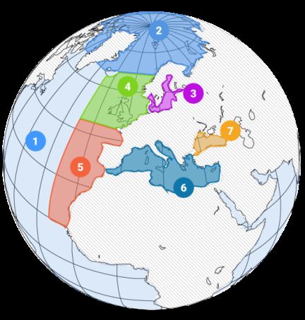
• Seven Monitoring and Forecasting Centres (MFCs), distributed according to the
marine area covered (Figure 1, including Global Ocean, Arctic Ocean, Baltic Sea,
North Atlantic West Shelf, North Atlantic Iberia-Biscay-Ireland area, Mediterranean
Sea and Black Sea). MFCs generate model-based products on the ocean physical and
biogeochemical states, including forecasts, analyses and reanalyses.
• A Central Information System (CIS), encompassing the management and
organization of the CMEMS information and products, as well as a unique User
Interface.
Figure 1. Regions covered by CMEMS.CMEMS SERVICE EVOLUTION STRATEGY: R&D PRIORITIES June 2017 4 4
3
KEY DRIVERS OF THE SERVICE
EVOLUTION AND RELATED R&D
PRIORITIES
The guidelines to identify the R&D activities to be organized within Copernicus or in
coordination with the service are motivated by several key drivers:
• Requirements from core users in the four main areas of benefit as recalled in the
Introduction, accounting for both existing needs and needs likely to emerge in the
future;
• Requirements from the CMEMS production centres based, in particular, on their 3-6
years R&D plans, considering the limitations in the daily service due to knowledge or
technological gaps identified to elaborate the products;
• Requirements motivated by the development of Copernicus downstream services;
• Requirements from European and international programmes dealing with Earth
observations, operational oceanography and Copernicus; notably GODAE OceanView,
the Copernicus Integrated Ground Segment (IGS) and GEOSS (Global Earth
Observation System of Systems);
• Outcomes of EU projects implemented under the Space theme (R&D to enhance
future GMES applications in the Marine and Atmosphere areas), such as MyWave,
OSS2015, E-AIMS, OPEC and SANGOMA or under FP7 and H2020 projects (e.g.
JERICO, PERSEUS, AtlantOS).
Additional drivers that reflect a more strategic view for the service evolution are also taken
into account, such as:
• EU directives implemented to regulate activities in the Marine sector (e.g., Marine
Strategy Framework Directive, Maritime Spatial Planning);
• New scientific and technological opportunities in the next 5-10 years, regarding both
satellite (e.g. the Sentinels suites) and in situ observations (e.g. plans for the global
BGC-Argo extension), modelling and assimilation capabilities, new communication
and data processing technologies, etc.
• The need to maintain competitiveness w.r.t. international players in operational
oceanography, as keeping a high-level know-how and innovation capacity will be
strategic to attract new users;
• Forthcoming activities involving Copernicus developments in the framework of other
European (e.g. EMODnet, EuroGOOS, EOOS) and global initiatives or programmesCMEMS SERVICE EVOLUTION STRATEGY: R&D PRIORITIES June 2017 5 5
(e.g. the Global Ocean Observing System in the context of GEOSS, GEO Blue Planet,
GODAE OceanView);
• The Sustainable Development Goals (SDG) defined as part of the UNEP 2030 Agenda
(especially SDG 14 - Conserve and sustainably use the oceans, seas and marine
resources for sustainable development);
• Outcomes of the 21st Conference of the Parties (COP21) to the UNFCCC (United
Nations Framework Convention on Climate Change) including the need for a global
stocktake to support emission agreements.
The constant dialogue with user communities as outlined above helped in identifying
overarching themes for the Service Evolution, focusing on:
i. A better description of ocean biogeochemical and ecosystem parameters in
particular to support reporting on marine environmental status in the regional
European seas, as required by the Marine Strategy Framework Directive (MSFD);
ii. The production of consistent ocean and wave information/products resulting
from the coupling between the ocean state, the atmosphere, surface wave
dynamics and other air-sea interface processes;
iii. A better interface between the CMEMS and coastal monitoring services
operated by Member States or private groups: this will require an improved
processing of satellite and in situ observations in the coastal zone as well as the
provision of suitable connectivity and boundary conditions between the Marine
Service and the national coastal systems;
iv. A better monitoring and description of the ocean state and its variability,
requiring the preparation and release of annual Ocean State Reports describing
the state of the global ocean and the European regional seas, in particular for
supporting the Member States in their assessment obligation;
v. A better assessment of the quality of CMEMS products, which requires
continuous upgrade of observation infrastructures and improved data
information and access services.
Moreover, it is identified that one overarching driver for service evolution remains a
continuous enhancement of modelling, data assimilation and forcing techniques at both
the air-sea interface and lateral boundaries (coasts, open boundaries), in order to exploit
the considerable investment in recent and upcoming observation technologies (e.g. SAR,
SARin, SWOT, CFOSAT) and observation infrastructures.
These priorities provide guidelines to the short, medium and longer term developments
outlined in section 4 below. The proposed R&D roadmap was established following an
analysis of R&D priorities by the CMEMS Scientific and Technical advisory committee (STAC)
set up to assist Mercator-Ocean for the CMEMS implementation.
This version (V4) released in November 2018 provides an update of R&D priorities and
develops the Service Evolution roadmap and plans for the coming years. It takes into
account, in particular, revised 3-year and 6-year evolution plans from the CMEMS TACs andCMEMS SERVICE EVOLUTION STRATEGY: R&D PRIORITIES June 2017 6 6
MFCs, past and on-going H2020 Copernicus projects (service evolution, downstream)
referred to in section 5, outcomes of the first call for tenders for CMEMS Service Evolution
(section 6), and a presentation of projects selected in the second call for tenders for CMEMS
Service Evolution (section 6).CMEMS SERVICE EVOLUTION STRATEGY: R&D PRIORITIES June 2017 7 7
4
R&D AREAS AND REQUIRED
DEVELOPMENTS
In this section, the 12 R&D areas required to support the service evolution guided by user
needs are described. The required developments are categorized in terms of time horizons
(short- to mid-term, and long-term) and expected objectives. The developments with short-
to mid-term objectives refer to R&D activities that are expected to deliver significant results
in less than 2 years, while longer-term activities are thought to need more than 2 years to
bear results that will impact the service. The sections addressing R&D priorities of the 4
over-arching themes that emerged from the strategic analysis made by the STAC are
organized as follows: ocean circulation modelling, mesoscale and other interactions, ocean-
wave and ocean-ice coupling (sections 4.1 to 4.4), biogeochemistry and ecosystems in the
marine environment (section 4.5), interactions with the coastal ocean (section 4.6) and
ocean-atmosphere coupling, reanalysis and indicators, and climate change (sections 4.7 and
4.8). Finally, sections 4.9 to 4.12 correspond to cross-cutting activities and methodologies
that will benefit the 4 overarching themes.
4.1 CIRCULATION MODELS FOR THE GLOBAL OCEAN, REGIONAL AND SHELF
SEAS
Expected evolutions
To support Copernicus marine users and decision-makers there will be an increasing demand
for model information on fine spatial scales, higher frequencies and with a more complete
representation of dynamical processes of the turbulent ocean. This is relevant to all areas
from the open ocean where the dynamics are significantly impacted by mesoscale eddies, to
transition areas connecting coastal and shelf seas and to critical regions (e.g. straits,
boundary layers) requiring high topographic resolution. Numerical models will be needed
with increased resolutions to represent the dynamics captured by existing and future Earth
Observation platforms (e.g. high-resolution wide-swath altimetry, geostationary sensors,
direct estimations of surface currents, high resolution sea surface temperature (SST), etc.)
and consistent with improved estimates of fluxes of freshwater and suspended matter at the
coast.
Required developments with short- to mid-term objectives
• Development of advanced physical parameterizations, numerical schemes and
alternative grids to improve the performance of ocean models resolving the
mesoscale and smaller scales;CMEMS SERVICE EVOLUTION STRATEGY: R&D PRIORITIES June 2017 8 8
• Adaptation of multi-scale and seamless downscaling/nesting capabilities to achieve
kilometric to sub-kilometric resolution over specific areas;
• Better resolution of surface currents (0-20 m depth) and higher-frequency processes
(e.g. tides) including their effects (e.g. rectification) and associated uncertainties on
the circulation and on the transport of tracers;
• Adaptation of forcing methods with consistent physical parameterizations that
benefit the fine scales (fronts, filaments) of surface ocean patterns;
• Improved capability in 3D storm surge forecasting for global and regional models, in
particular new strategies to incorporate atmospheric surface pressure data, tidal
forcing and coupled ocean-wave-atmosphere effects;
• New strategies and algorithms to solve the model equations efficiently on next
generation computing systems: this should result in code performance improvements
on most intensive HPC applications, which is crucial to sustain operational
production;
• Development of empirical or other atmospheric modelling techniques to improve the
spatial and temporal resolution of atmospheric forcing.
Required developments with longer-term objectives
• Modelling issues related to multi-scale and multi-physics and in particular model
nesting and unstructured grids;
• Development of non-hydrostatic ocean models to represent the full evolution of fine-
scale oceanic structures in the three spatial dimensions;
• Understanding of fine scale processes to guide the development of global ocean
analyses and forecasts at increased resolution and complexity (e.g. including
representations of tidal physics, mixing and wave-current interactions).
4.2 SUB-MESOSCALE - MESOSCALE INTERACTIONS AND PROCESSES
Expected evolutions
Our knowledge on the relationships between the physical, chemical and biological processes
in the upper ocean is continuously improving. This is essential for understanding and
predicting how the ocean and the marine ecosystems respond to ocean dynamics and
changes in atmospheric forcing. Advection, mixing and enhanced vertical velocities
associated with mesoscale and sub-mesoscale oceanic features such as fronts, meanders,
eddies and filaments are of fundamental importance for the exchanges of heat, fresh water
and for biogeochemical tracers between the surface and the ocean interior, but also for
exchanges between the open oceans and shelf seas, and between the pelagic ocean and the
benthos.
The challenges associated with mesoscale (20-300 km, Rossby numbers < 1, and time scales
from weeks to a few months) and sub-mesoscale variability (between 1-20 km, Rossby and
Richardson numbers O(1), and time scales from minutes to a few days) require high-CMEMS SERVICE EVOLUTION STRATEGY: R&D PRIORITIES June 2017 9 9
resolution observations (both in situ and satellite) and multi-sensor approaches. Accordingly,
multi-platform synoptic experiments have to be designed in areas characterized by intense
density gradients and strong mesoscale activity to monitor and establish the vertical
exchanges associated with mesoscale and sub-mesoscale structures and their contribution
to upper-ocean interior exchanges. In situ systems, including ships, profilers and drifters
should be coordinated with satellite data to provide a full description of the physical and
biogeochemical variability and will be combined with resolution numerical simulations.
Focus should be made on a range of scales (15-100 km) traditionally not resolved by
conventional altimeters but in which the wide swath altimeter SWOT will make an
unprecedented contribution. At the same time, the realistic representation of the
generation and evolution of such processes in numerical ocean models remains very
challenging due to the chaotic nature of the oceanic flow, making direct model-data
comparisons at the smallest scales problematic.
Required developments with short- to mid-term objectives
• Predictability studies to assess the feasibility of developing open ocean and
coastal/regional seas’ forecasts with lead-time of a few days to weeks, together with
assessment of likely prediction skill;
• Methods to assess the relative impact of sub-mesoscales and internal waves on sea
surface height and in situ observations;
• Methods to account for turbulence-submesoscale interactions into numerical
models, topographic interactions at small scales, mixing induced by internal waves
and other interacting processes between internal waves and submesoscale eddies;
• Development of new metrics adapted to the increased resolution in both
observations/products and models.
Required developments with longer-term objectives
• Synthesis from multidisciplinary field experiments and numerical studies to assess (i)
systematic error in ocean models induced by sub-mesoscale dynamics, (ii) impact of
vertical exchanges associated with mesoscale and sub-mesoscale structures, and (iii)
operational products in specific areas;
• Process studies focused on physical-biological interactions at sub-mesoscale,
implications for biogeochemistry, productivity, export, ecosystem structure and
diversity;
• Improved understanding of vertical exchanges associated with oceanic mesoscale
and sub-mesoscale features (e.g. fronts, meanders, eddies and filaments) through
the combined use of in situ, satellite data and numerical models;
• Assess the impact of solving the ocean dynamics at kilometric scales on the role of
ocean on climate (e.g. vertical exchange of heat and carbon, representation of
overflows).CMEMS SERVICE EVOLUTION STRATEGY: R&D PRIORITIES June 2017 10 10
4.3 COUPLED OCEAN-MARINE WEATHER INFORMATION, SURFACE CURRENTS
AND WAVES
Expected evolutions
The most important ocean weather parameters delivered by CMEMS are ocean currents,
temperature (in particular in the near-surface layer of the ocean), sea ice, sea level, waves
and surface winds. For several marine and coastal applications, information on surface
parameters, including total and non-tidal currents and waves, is highly important. One
example is the off-shore industry, where information on wave height and period are
fundamental in the decision making (e.g. when ocean platforms need to be evacuated during
violent storms). Everyday activities along the coasts heavily depend on wave information.
Information on surface waves is also an essential input to the risk analysis in storm flood
events.
Waves are a bridge between the ocean and the atmosphere. Therefore, surface fluxes and
winds used to drive the wave and ocean circulation should be consistent. The quality of
wave forecasts and analyses is strongly linked with the quality of the wind forcing. Waves
are also an important mixing agent with an active role in erosion and resuspension
processes.
In 2012, the EU funded project MyWave was established to lay the foundation for a future
Service that also includes ocean waves. Additional efforts funded under the 1st CMEMS SE
call are underway to support the production of more consistent ocean-marine weather
information, including information on surface waves. However, the two-way coupling
between ocean and wave processes has to be further developed and improved.
Required developments with short- to mid-term objectives
• Improved methods for analysing and predicting upper ocean currents;
• Improved processing methods to retrieve wave and surface currents (total and non-
tidal) information from the relevant satellite data, such as wave height based on
altimeters (e.g. Sentinel 3) and wave information from SAR (e.g. Sentinel 1) and
CFOSAT;
• Improved processing methods to retrieve wave information (including integrated
parameters such as significant wave height) from in situ platforms (buoys, moorings,
HF radars, etc);
• Developments to implement fully coupled ocean-wave models in which both
components will exchange information at high frequency, and development of
coupling parameterizations (bulk parameterizations for instance), both in the open
ocean and near the shoreline;
• Investigations of wave model error dependencies on swell parameters (usually
source of the largest errors) and improved parameterizations;
• Improved wave modelling near the ice edge and in ice-infested waters.CMEMS SERVICE EVOLUTION STRATEGY: R&D PRIORITIES June 2017 11 11
Required developments with longer-term objectives
• Improved modelling of extreme and rogue waves ;
• Implementation of advanced techniques to assimilate data into fully coupled ocean-
wave-atmosphere model systems;
• Improved characterisation of the uncertainties in coupled ocean-wave analyses and
forecasts.
4.4 NEW GENERATION OF SEA-ICE MODELLING
Expected evolutions
There is evidence of a number of shortcomings in modelling the coupled ocean-sea-ice-
atmosphere system at high latitudes that continue to limit the quality of operational
products delivered to users (both real-time as well as reanalyses). The 10 km to 100 km wide
Marginal Ice Zone where ocean waves and sea ice processes are coupled is expected to
widen in a warmer Arctic, but is still not well represented, neither in data nor in operational
models. Additionally, products for fisheries (having a very strong economic value) depend on
several qualities of both physical models (mixing, horizontal and vertical advection of larvae)
and primary and secondary production models.
Some shortcomings are inherent to the traditional viscous-plastic sea-ice rheology (and
elastic-viscous-plastic as well) used in the current sea-ice models, deformations of sea ice
being not correctly represented and in turn the velocity of sea ice drift being also incorrect.
The ability to assimilate sea ice drift is also impaired by such model biases. In addition, the
inclusion of more non-linear, chaotic processes are expected to become increasingly
challenging for assimilation methods, in a context where more observations will be delivered
from space, especially through the Sentinel suite.
Required developments with short- to mid-term objectives
• New methods designed to assimilate satellite sea ice observations, such as the type
and thickness of sea ice and more detailed information available from SAR imagery,
together with impact assessments;
• Sea-ice models based on a more realistic rheology (for instance rheological models
based on solid mechanics rather than fluid mechanics and their inclusion into
operational models);
• Improved coupling between ocean waves and sea-ice processes;
• Improved physical modelling of mixing below sea ice;
• Improved sea ice thermodynamics that will include effects of surface melt ponds;
• Coupling with snow models to account for ageing of snow and blowing snow;
• Development of a new generation of sub-kilometer scale dynamic sea ice models
able to resolve ice floes.CMEMS SERVICE EVOLUTION STRATEGY: R&D PRIORITIES June 2017 12 12
Required developments with longer-term objectives
• Representation of biological cycles in sea ice, including optical properties of sea ice
and vertical migration of nutrients in sea ice;
• Specific development for modelling of the Marginal Ice Zone, taking into account the
heterogeneity in sea ice coverage and coupling effects with ocean and atmosphere
and waves at fine scales;
• Developments on sea-ice models and data assimilation targeted to initialize coupled
ocean-atmosphere and sea-ice forecasts for a wide range of time scales.
4.5 MODELLING AND DATA ASSIMILATION FOR MARINE ECOSYSTEMS AND
BIOGEOCHEMISTRY
Expected evolutions
Users of the future CMEMS will benefit from the gradual improvement of models and tools
to monitor the biogeochemical state of the ocean and marine ecosystems in ocean basins
and marginal seas, using model-data integration and assimilation methodologies. This will
require very significant strengthening of the observation system of the “green” ocean
component at a range of scales, including in regional and coastal seas. In addition to the
Sentinel suite, the potential of future satellite sensors (e.g. imagers from geostationary
satellites) should induce a breakthrough in the monitoring of coastal areas and the land-
ocean interface. Moreover, monitoring the concentration and distribution of pollutants will
be essential for predicting ecosystem responses to pollution. Other challenges on the marine
component of the carbon/greenhouse gases cycles will also require significant R&D effort as
significant gaps in monitoring tools also exist in this area.
During the past years, a suite of EU funded projects has developed the processing of remote-
sensing data for open ocean and coastal waters (see section 5) as well as prototype
ecological marine forecast systems for ocean basins and European seas (Atlantic, Baltic,
Mediterranean and Black Seas) which include hydrodynamics, lower and higher trophic
levels. More recent projects funded under the 1st CMEMS Service Evolution R&D call will
deliver further advances for multi-platform biological data assimilation, data assimilation of
phytoplankton functional types and delivery of ecosystem enriched products. There is an
expectation that the integrated Atlantic Ocean observing system will increase the number
and quality of in situ observations on chemistry, biology and ecology over the next decade. A
co-evolution of the data use in assessment and predictive models holds great potential for
new products and users.
It is required that results from these projects as well as similar advances in the field be
transferred to CMEMS in order to consolidate the core ecosystem component of the service.CMEMS SERVICE EVOLUTION STRATEGY: R&D PRIORITIES June 2017 13 13
Required developments with short- to mid-term objectives
• Improved modelling and assimilation capabilities for the representation of ocean
biogeochemistry and the marine food web from primary production to higher trophic
levels (plankton to fish), including estimations of uncertainty;
• Relationships between optical properties and biomass for direct assimilation of
optical properties into biogeochemical models;
• Improving CMEMS monitoring (i.e. products derived from satellite and in situ
observations) and modelling products to better support aquaculture management
applications;
• Improved pH and carbon monitoring and forecasting: carbonate system
observations, modelling and assessment at regional and global scales;
• Methods to generate operational products in addition to standard (T, S, Chl, –
oxygen, pH, nutrients, light, plankton biomass) in support of predictive habitat
forecasts, for ecological status and fisheries modelling and risk assessment (e.g.
invasive species, harmful algal blooms, marine protected area planning);
• Multi-objective assimilation capabilities, e.g. combining state and parameter
estimation, combining ocean colour and sub-surface data from BGC-Argo, gliders and
other relevant ecological observations especially in regional seas;
• Demonstration of consistent interfacing (nesting, downscaling) between open ocean
biogeochemical models and regional/coastal ecosystem models and downstream
applications;
• Standardized validation methods for ecosystem model products/variables
(particularly related to non-assimilated observations/variables).
Required developments with longer-term objectives
• Improved description of benthic-pelagic coupling on short-term (seasonal) and long-
term (decadal) scales; identification of the impact of initial conditions;
• Improved methodologies for supplying operational information on sources of
nutrients and pollution/chemicals to the oceans;
• Develop a system for routine model estimates of the dose and direct and indirect
effects of pollution on communities of algae, zooplankton and fish larvae.
4.6 SEAMLESS INTERACTIONS BETWEEN CMEMS AND COASTAL SYSTEMS
The coastal monitoring services operated by Member States or private groups will form an
important and strategic group of users of the CMEMS. These activities will enhance the
socio-economic value of CMEMS by contributing to the MSFD, spatial planning and other
downstream applications (offshore operations, coastal engineering, habitat monitoring,
aquaculture, harmful algal bloom monitoring, adaptation and mitigation to climate change).
Downscaling also includes the integration of coastal stations, and the role of CMEMS
regional products is also to fill gaps between coastal observatories.CMEMS SERVICE EVOLUTION STRATEGY: R&D PRIORITIES June 2017 14 14
However, the “one-way” vision of a core service delivering information to downstream users
without feedback to upstream providers has a number of limitations since the coastal strip
should also be considered as an “active” boundary layer that influences the open ocean
region connected to coastal areas. Scientifically, interactions between land, littoral, shelf,
regional and abyssal seas are still a major unknown, poorly characterized and modelled. It is
therefore needed to develop the CMEMS in such a way as to enable more efficient
interfacing with a large variety of coastal systems describing the physical and
biogeochemical coastal ocean states and ecosystems. Future operational circulation models
implemented in the open ocean in CMEMS should enable more flexible coupling with a
variety of model codes and regional configurations specifically customized for coastal
dynamics and benefiting from user experience and practices, including those interfaced with
near-shore, estuary models and hydrological models, unstructured grid models in areas that
require very high resolution with good representation of topographic features.
These issues have been explored in a number of recent EU-funded and national projects,
relying on the coordinating role of EuroGOOS with the objective to consolidate, integrate
and further develop existing European coastal and regional operational observing and
forecasting systems into an integrated pan-European system targeted at detecting
environmental and climate changes, predicting their evolution, producing timely and quality
assured forecasts, and providing marine information services (including data, information
products, knowledge and scientific advices). In the ongoing H2020 CEASELESS project for
instance, it will be demonstrated how the new Sentinel measurements will support the
development of a coastal dimension in Copernicus by providing an unprecedented level of
resolution, accuracy and continuity with respect to present products.
Furthermore, it also becomes timely to explore the possible connections between the
CMEMS and the Copernicus Land monitoring service as coastal users will rely on information
from both services. Therefore, an expert workshop was recently organized by EEA and
Mercator Ocean with the objective to better address user needs in the coastal zone (see
section 6.5). The required developments listed below are partly inspired from the main
conclusions of this expert workshop.
Required developments with short- to mid-term objectives
• Improved and standardised inputs of freshwater flows and associated river inputs of
particulate and dissolved matter and homogenised river forcing approaches in global,
regional and coastal models;
• Improve the interfaces/interactions between coastal monitoring and modelling
systems and CMEMS;
• Comprehensive impact studies of CMEMS boundary conditions on coastal systems
(physics, biology) and their applications (e.g. MSFD);
• Data assimilation and ensemble forecasting improvements to better serve the coastal
applications;CMEMS SERVICE EVOLUTION STRATEGY: R&D PRIORITIES June 2017 15 15
• Development of flexible interfaces between regional and coastal models, including
near-shore and estuarine models and with the capability to connect structured and
unstructured grids.
Required developments with longer-term objectives
• Adoption of robust standards to ensure compatibility between CMEMS and
downstream systems;
• Connection and coupling with land hydrology models.
4.7 COUPLED OCEAN-ATMOSPHERE MODELS WITH ASSIMILATIVE CAPABILITY
Expected evolutions
While coupled ocean-atmosphere models have been developed for a while in the context of
climate research and weather forecasting, the MFC systems in CMEMS are currently based
on a “forcing mode” approach (except for the GLO-CPL forecasting system) in which the
ocean is driven by surface momentum, heat and freshwater fluxes computed using specified
atmospheric information at fairly coarse space-time resolution. This could be an issue due to
the different scales of variability in the atmosphere and ocean systems. In particular, the lack
of feedback at fine scales between ocean and atmospheric models leads to inconsistencies
and has implications for the practical forecasting capability of regional and coastal
environments. Furthermore, the existence of observations at the ocean-atmosphere
interface is an opportunity to introduce assimilation constraints into coupled models,
especially for regional/coastal applications of interest to Copernicus users.
Required developments with short- to mid-term objectives
• Advanced assimilation methods targeted to provide improved estimations of upper
ocean properties consistent with sea-surface observations and air-sea fluxes;
• Representation of diurnal variability and cool skin layer in forced ocean and coupled
ocean-atmosphere models;
• Consistent numerical schemes to improve the representation of ocean-wave-
atmosphere interactions for regional oceanic applications;
• Use of ocean wave spectra to determine contributions to boundary layer momentum
fluxes.
Required developments with longer-term objectives
• Novel ocean forcing approaches that may include simplified atmospheric boundary
layer dynamics and ocean feedbacks at high spatial resolution;
• Analyses of impacts and feedbacks resulting from coupling between ocean,
atmosphere and waves on the surface ocean dynamics and biology, including in the
case of extreme events;
• Facilitate collaboration with the atmospheric community for exploitation of the
surface observations common to the coupled ocean-sea-ice-atmosphere interface,CMEMS SERVICE EVOLUTION STRATEGY: R&D PRIORITIES June 2017 16 16
such as surface winds, surface currents, SST, waves, radiative, freshwater and heat
flux components, sea-ice concentration, sea-ice thickness and sea-ice temperature;
• Multivariate data assimilation into fully coupled ocean-wave-atmosphere dynamical
systems.
4.8 OCEAN CLIMATE PRODUCTS, INDICATORS AND SCENARIOS
Several CMEMS systems produce analyses and reanalyses or multi-year reprocessed
observations that describe ocean variability and changes. Ocean Monitoring Indicators (OMI)
can be derived from these products for tracking ocean mechanisms and/or climate modes
and trends, much as we use global greenhouse gas (GHG) concentrations to follow
anthropogenic effects, and globally averaged SST to monitor warming. CMEMS is developing
OMIs for monitoring the ocean state at global and European scales (see the CMEMS Multi-
Year Product Strategy Plan, section 6.1).
Many users are also interested in future trends and evolution of the marine environment
under different climate scenarios. Earth system and climate model predictions (seasonal to
decadal) and longer-term projections based on GHG scenarios, together with comprehensive
ocean reanalyses, can be used to infer possible changes in the ocean state at regional and
coastal levels, including biogeochemical and other aspects of the marine environment (e.g.,
related to harmful algal blooms and other marine extreme events). In the field of ecology,
our scientific understanding of ecosystems has matured to a point that we may be able to
produce potential scenarios based on our knowledge of potential future change in the
physical system (e.g. water quality, coral bleaching).
Such outcomes require the production of improved ocean reanalyses and multi-year
reprocessed observations suitable for climate change detection, with reduced systematic
errors and improved dynamical and physical consistency and realism. Reanalyses product
quality delivered by the CMEMS will have to be monitored on a continuous basis, using
proven, verifiable and robust methodologies that can be agreed upon with external partners
(see section 6.1). This activity can rely on standard metrics (e.g. as defined in the
international GODAE Ocean View framework) or on new approaches.
These activities will contribute to the Ocean State Reports delivered by CMEMS, and will also
benefit from the development of the Copernicus Climate Change Service (C3S) line.
Required developments with short- to mid-term objectives
• Development of methods for inferring the future state (from seasons to decades) of
the marine environment (physics and biogeochemistry) at regional and coastal scales,
as well as changes in ecosystems, based on climate model predictions and
projections (and associated tests for quality and reliability);
• Development of Ocean Monitoring Indicators based on CMEMS and other products;
specific needs include indicators (i) for the physical ocean state, variability andCMEMS SERVICE EVOLUTION STRATEGY: R&D PRIORITIES June 2017 17 17
change monitoring (ii) for the health of the ocean (e.g. acidification, deoxygenation,
eutrophication), (iii) for fishery and aquaculture management and (iv) for other
applications such as maritime transport, marine renewable energy, coastal zone
management;
• Framework for coordination / intercomparisons with international community efforts
(EuroGOOS, GODAE OceanView, CLIVAR, CMIP activities …);
• Methods to ensure quality, homogeneity and robust uncertainty measures in long-
term time-series reconstructed from data or model reanalyses.
Required developments with longer-term objectives
• Development of methods for inferring the future state (from seasons to decades) of
the marine environment (physics and biogeochemistry) at regional and coastal scales,
as well as changes in ecosystems, based on climate model predictions and
projections (and associated tests for quality and reliability) [continued].
4.9 OBSERVATION TECHNOLOGIES AND METHODOLOGIES
Expected evolution
The observing system, which today provides regular and systematic data on the physical
state and dynamics of the ocean and marine ecosystems, is expected to evolve in several
directions during the next years:
• The global in situ component, through coordinated programmes such as Argo and its
extensions (deep ocean, polar seas and BGC), Atlantos in the Atlantic and TPOS2020
in the Pacific Ocean , is expected to more systematically collect data on new chemical
and biogeochemical state variables (oxygen, bio-optical properties, nutrients, pH) in
addition to conventional temperature and salinity profiles, and to increase the
sampling of the deep (below 2000 m) and ice-covered seas;
• The European regional and coastal seas will be monitored through more
coordinated, multi-sensors and multi-parameter networks including HF radars,
cabled structures, fixed platforms, ferry boxes, surface drifters, gliders, and other
new technologies, e.g. undertaken under EuroGOOS, EMODnet, the EOOS (European
Ocean Observing System) initiative and other projects (e.g. JERICO-Next, AtlantOS);
• The space component will rely on a mixture of operational (e.g. the Sentinel suite)
and exploratory missions, providing sea-level (both along-track and wide-swath),
geoid information, SST, ocean colour, surface salinity, surface wind and currents,
wave properties and sea-ice parameters;
• New capabilities are expanded to sample a variety of scales through multi-platform
observing systems that include more and more autonomous platforms with multi-
disciplinary sensors;
• Observations delivered through Copernicus or in cooperation with other initiatives
will increase, especially those dedicated to validation measurements followingCMEMS SERVICE EVOLUTION STRATEGY: R&D PRIORITIES June 2017 18 18
agreed protocols (e.g. ESA protocols, quality assurance framework for Earth
observation guidance);
• Ocean observing systems will be multi-purpose and have multiple uses, observing the
ocean at multiple scales and from the coastal to the open ocean, delivering quality
controlled data to science and society.
New multi-platform and multi-disciplinary approaches combining both in situ (e.g. gliders,
Argo, ships, drifters, fixed platforms) and satellite observations at high resolution will be
needed to resolve a wide range of temporal and spatial scales, to monitor key regions or
processes for the ocean state and its variability and to fill gaps in our knowledge connecting
physical processes to ecosystem response (e.g. BGC Argo, TPOS2020, Atlantos, GOOS). In
addition, there is a huge potential to more efficiently access/use data from different
industrial platforms, including off shore power stations.
The core data set assimilated in CMEMS real-time models or multi-year reanalysis systems
include SST, sea-level anomalies and T/S profiles (almost systematically), sea-ice
concentration (whenever possible), and chlorophyll concentration (occasionally). In addition
to consolidating the assimilation of such data, a broader list of parameters should be
integrated into monitoring and forecasting systems within the next 3-10 years.
Required developments with short- to mid-term objectives
• Improved processing of Sentinel 1, 2, 3 data for coastal ocean products and
applications;
• Adaptation of existing quality-control methods to new observing system
components, both in situ (for instance new biogeochemical parameters) and satellite,
with a focus on Sentinel observations and future exploratory missions (e.g. CFOSAT,
SWOT); advancement and adoption of international calibration and quality-control
procedures;
• Developments of advanced protocols for real-time quality checking and automated
flagging procedures that are more consistent with nowcast/forecast information
delivered by MFCs;
• More consistent processing and assembly of data from different, heterogeneous
observation platforms and sensors for estimating derived quantities (e.g. sea-ice
products, surface currents, mixed-layer depth, primary production, nutrients from
temperature, salinity and O2 vertical profiles etc.);
• Incremental development of assembly centres to include more observations relevant
to coastal waters but also of interest to the monitoring of regional seas.
Required developments with longer-term objectives
• Exploitation of new technologies and platforms to more systematically observe pH
and pCO2 in ocean basins ;
• Adaptation of assembly centres procedures to take advantage of new sensors,
communication technologies and unification of procedures, protocols, access and
download systems across assembly centres.CMEMS SERVICE EVOLUTION STRATEGY: R&D PRIORITIES June 2017 19 19
4.10 OBSERVING SYSTEMS: IMPACT STUDIES AND OPTIMAL DESIGN
Expected evolutions
Regarding future observing systems (from space or in situ), the best possible basis is
required in the design and exploitation of observation networks and satellite constellations.
This goal can be ideally achieved through impact and design studies (Observing System
Experiments – OSEs; Observing System Simulation Experiments - OSSEs) and dedicated
process experiments and pilots. OSEs and OSSEs represent a useful investment when
expanding an existing observing system, defining a new one, or preparing the assimilation of
new data types, or data with improved resolution/accuracy. They are also required for
design studies to re-assess the sampling of the present in situ networks, define the required
extensions, and prepare the assimilation of new in situ data types considering the synergies
with satellite observations. Such approaches enable a consistent approach to the
assessment of the impact of observation data, assimilation techniques and analysis/forecast
systems, the definition and operation of space missions (upstream and downstream) and in
situ networks.
The existing TAC and MFC capabilities provide an excellent opportunity to develop a new
functionality within the CMEMS, and conduct impact studies and observing system design
based on rigorous and objective methodologies. This functionality will consolidate the link
between CMEMS and the data providers by formalizing recommendations on future
observing systems. In return, improving the design of future observing systems will be of
great benefit to CMEMS itself given the likely impact on the products quality.
Required developments with short- to mid-term objectives
• Adaptation of tools and diagnostic methods such as Degrees of Freedom Signal (DFS)
and Forecast System Observation Impact (FSOI) to measure the impact of
observations into ocean monitoring and forecasting systems;
• Adaptation of assimilation interfaces (e.g., observation operators) to new satellite
sensors: wide-swath altimetry, ocean colour, SST from Sentinels, surface currents …;
• Development of more robust methodologies (i.e. to ensure results as independent as
possible from model and error assumptions) and automatic tools to conduct impact
studies (including the OSE class);
• Impact studies of new observation data types or products for ocean analyses,
forecasts and reanalyses (e.g. SSS from space, Sea Ice thickness from Cryosat and
SMOS, surface current data sets, BGC-Argo, HF Radars, etc.);
• Network studies that will provide guidance to deployments: this includes identifying
critical ocean observation points and regions where the benefit to forecast skill and
ocean analyses and reanalyses can be maximized.
Required developments with longer-term objectives
• Design studies to re-assess the sampling of the present-day in situ T/S network (Argo
including BGC-Argo, ships, buoys, moorings);CMEMS SERVICE EVOLUTION STRATEGY: R&D PRIORITIES June 2017 20 20
• Guidance to the in situ observation communities on how to optimize observing
strategies and the synergies with Sentinel and future wide-swath altimetry missions
(SWOT), complementing the ongoing AtlantOS effort.
4.11 ADVANCED ASSIMILATION FOR LARGE-DIMENSIONAL SYSTEMS
Expected evolutions
The operational suites implemented in the CMEMS MFCs essentially rely on traditional
assimilation methods inherited from the Kalman filter or the 3DVAR approach including
simplifications and adaptations to make them tractable with large-dimensional systems.
Today, only the Arctic MFC has explicitly implemented the EnKF to propagate the spread of
an ensemble of likely states between successive updating steps, though several other MFCs
intend to implement ensemble approaches in the future (Global, Mediterranean, Baltic
MFCs, Figure 1).
The current trend in oceanic and atmospheric data assimilation is a move toward
probabilistic methods inherited from the Bayesian estimation framework, as reflected in a
variety of activities conducted in recent projects (e.g. FP7 SANGOMA), or reported in
workshops (e.g., GODAE Ocean View task teams) and conferences (WMO symposium on
Data Assimilation).
At CMEMS level, it becomes urgent to take advantage of these developments in order to
(i) further develop the assimilation methods to enable implementation into systems
involving different components (coupling with atmosphere, biology, biogeochemistry,
cryosphere, etc.), (ii) improve the coupling between assimilative systems with different
target resolutions and different assimilation parameterizations, (iii) implement an effective
production of probabilistic information as needed by users to support decision-making, and
(iv) improve the physical consistency of ocean state estimations, ensuring that the small-
scale dynamics simulated by ocean models is in balance with the larger scales captured by
the observing systems.
In the NEMO framework (most MFCs systems are based on NEMO), a new assimilation
component has been implemented in the reference version that includes several modules
(observation operators, linear-tangent and adjoint of the circulation model, incremental
updating schemes) to facilitate coupling with various assimilation systems. It is also planned
to include an ensemble simulation mode in future versions of NEMO. Other efforts on
modular software development have also been initiated in European institutions, such as the
Object-Oriented Prediction System (OOPs) project at ECMWF. A convergence between these
parallel efforts is expected in order to ensure an effective implementation of these
developments into the large-scale systems based on NEMO.
Required developments with short- to mid-term objectives
• Metrics for ocean analysis/reanalysis and forecasting produced using ensemble
techniques;CMEMS SERVICE EVOLUTION STRATEGY: R&D PRIORITIES June 2017 21 21
• Development and application of advanced assimilation methods, including to identify
and understand model bias and forcing errors, with a focus on ocean reanalyses;
• Adaptations of ensemble-based assimilation/forecasting systems, and development
of new techniques to increase the range and amount of observations assimilated into
MFCs (e.g. ocean currents, ice thickness, ocean colour), making best use of
Copernicus Sentinel missions;
• Common developments on assimilation modules to connect models and assimilation
kernels shared between different MFCs;
• Extension of conventional assimilation schemes to include image data information
(SST, Ocean Colour) in addition to pixel data;
• Efficient methods to account for complex observation and modelling error structures
(incl. non-Gaussian errors) in assimilation algorithms;
• Adaptation of analysis schemes to process different spatial and temporal scales
during the analysis stage;
• Adaptation of analysis schemes to preserve the consistency of non-observed
quantities such as vorticity, diffusion, vertical velocity, passive tracers etc.;
• Verification methods and intercomparison protocols (rank histograms, Continuous
Rank Probability Score, …) suitable to assess the reliability of ensembles in
probabilistic assimilation systems;
• Inverse methods that will incorporate simplified balance relationships (e.g.
geostrophic and vorticity balance, omega equation) to ensure physically consistent
products.
Required developments with longer-term objectives
• Development of data assimilation tools for coupled models (ocean-atmosphere
including waves, physics-biogeochemistry, ocean-shelf models), including consistent
coupled initialization approaches and flux correction schemes at interfaces;
• Developments of software infrastructure that can accommodate different
assimilation methods and facilitate the sharing of algorithms and optimization of
computer codes (models, assimilation schemes) on HPC.
4.12 HIGH-LEVEL DATA PRODUCTS AND BIG DATA PROCESSING
Expected evolutions
CMEMS needs to enrich its offer with improved accessibility and quality controlled data, in
agreement with scientific community standards. Users are also requesting advanced data
products that should rely on more complex processing of measurements of essential ocean
variables at higher resolution, including the provision of composite products and their
uncertainty estimates. Those data products will feed monitoring and forecasting systems or
validate model outputs. The ESA Climate Change Initiative and the Copernicus ClimateYou can also read