Cruising Guide to Port Hacking - Last Updated in December 2018 A view of Port Hacking looking to the east with Lilli Pilli in the foreground ...
←
→
Page content transcription
If your browser does not render page correctly, please read the page content below
A view of Port Hacking looking to the east with Lilli Pilli in the foreground.
Maianbar Shoals and Deeban Spit are evident with Bate Bay in the far background

       Cruising Guide to
         Port Hacking
                              Last Updated in
                              December 2018

Port Hacking Cruising Division
Index
Description Page Number
Destination Summary ....................................................................................................................... 4
History of Port Hacking, NSW........................................................................................................... 7
About Port Hacking .......................................................................................................................... 9
The Story of Trim............................................................................................................................ 10
The adventures of Trim .......................................................................................................... 10
Shipwrecked and imprisoned ................................................................................................. 11
Mapping of Australia .............................................................................................................. 11
Cruising contact system ................................................................................................................. 12
Clubs, Marinas and Fuel................................................................................................................. 13
Royal Motor Yacht Club - Port Hacking.................................................................................. 13
Cronulla Sailing Club Ltd ....................................................................................................... 13
Yowie Bay Marina .................................................................................................................. 13
Port Hacking Open Sailing Club............................................................................................. 13
Cronulla Marina ..................................................................................................................... 14
Dolans Bay Marina Pty Ltd .................................................................................................... 14
Burraneer Bay Marina ............................................................................................................ 14
The Channels of the Port (October 2021) ....................................................................................... 15
Map of Port Hacking ....................................................................................................................... 17
Radio coverage frequencies repeaters etc ..................................................................................... 18
Volunteer Marine Rescue – NSW Bases ........................................................................................ 20
Important Telephone Numbers - All Emergencies only Phone 000 ................................................. 23
Trim: The True Story of a Remarkable Cat ..................................................................................... 24
The Curranulla story ....................................................................................................................... 26
Beaufort Wind Scale ....................................................................................................................... 31
Anchorages .................................................................................................................................... 33
Boat Harbour ......................................................................................................................... 33
The Boatshed Cafe at La Perouse ......................................................................................... 35
Wattamolla (Providential Cove).............................................................................................. 36
Whale Watching .................................................................................................................... 42
Jibbon Beach ......................................................................................................................... 48
Bundeena - Horderns and Gunyah Beach ............................................................................. 50
Gunnamatta Bay .................................................................................................................... 55
Salmon Haul .......................................................................................................................... 56
Wildflowers of Cabbage Tree Creek ...................................................................................... 56
Deeban Spit, and the Sand spit ............................................................................................. 59
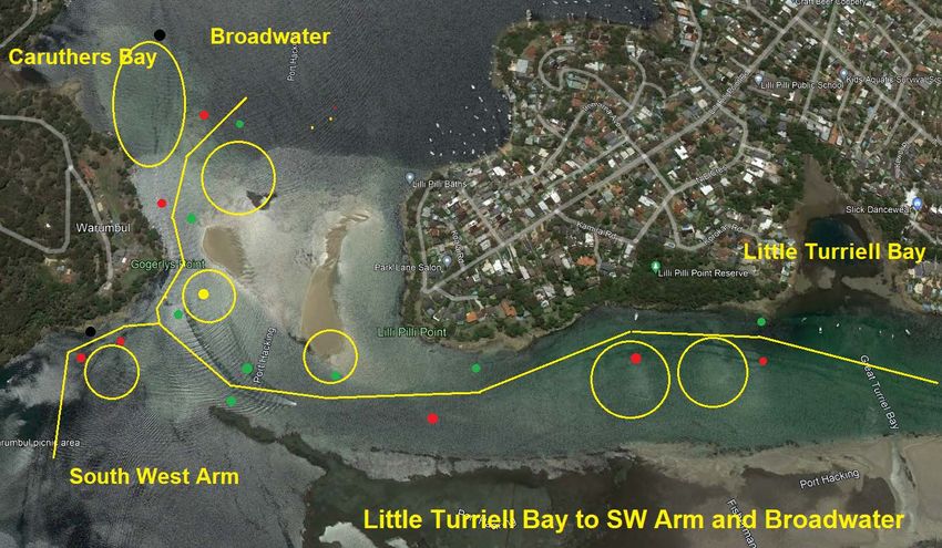
Rathane and Gogerly’s Point ................................................................................................. 63
South West Arm and gooseberry Bay .................................................................................... 65
Upper Reaches of SW Arm and Winifred Falls ...................................................................... 67
Anice Falls ............................................................................................................................. 69
Caruthers Bay and Darks Bay................................................................................................ 71
Farnell Bight .......................................................................................................................... 72
Audley Weir in the Royal National Park ................................................................................. 74
Grays Point and the Wildflowers of Muddy Creek .................................................................. 78
Rules of Cruising (In progress) ....................................................................................................... 81
Cruising hints (In progress) ............................................................................................................ 82
Aquabelle’s Cruise to Port Hacking – by Paul Greenhalgh ............................................................. 86
Lake Macquarie a rough guide by Greg Cooke............................................................................ 92
Cruising destinations South of the Port........................................................................................... 94
Favourite Recipes on Board ........................................................................................................... 96
Date: December 2015 Broadwater Yacht Club
Page 3 of 98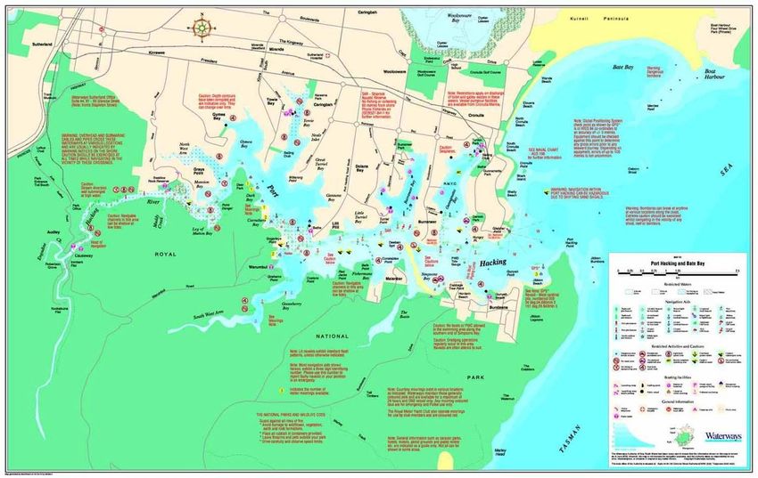
Port Hacking Cruising Group
Destination Summary
01 Sep 2010 (Edited summary)

The greater Sydney region holds some of the best
waterways in the world and none better than the
creeks and rivers that make up Port Hacking, reports
Matthew Smeal.

To have such variety within a small area makes this
area unique. Pittwater to the north and moving
southwards, Sydney Harbour, Botany Bay and Port
Hacking all have their similarities yet are vastly different; offering visiting cruisers plenty of choice.

Botany Bay, with its industry and airport, would never be considered a tranquil cruising ground. Sydney
Harbour has some beautiful areas, quite apt for the most beautiful harbour in the world, but it is still a
major port in Australia’s largest city.

Pittwater is the general ‘go to’ cruising ground for Sydney sailors and visitors alike, but meanwhile, at
the southern end, lies Port Hacking, often referred to as ‘Sydney’s forgotten waterway’, as the locals,
will tell you. ‘I think it’s one of the best waterways on the New South Wales coast,’ said Bruce McKay.

‘There’s clean water, it’s sheltered, there’s friendly boat owners and, because it’s smaller, there’s more
camaraderie ‘everybody knows each other.’ There are also plenty of facilities in the area with services
at Cronulla Marina and the very sheltered Burraneer Bay Marina and shop.

History
Called ‘Deeban’ by the local Aboriginal people, Port Hacking was named by Matthew Flinders and
George Bass in 1796. They named it after hunter Henry Hacking who told them about the area and the
river in particular. Like Pittwater, Port Hacking is also bordered by national park, in this case, the Royal
National Park. Similarly, this greatly contributes to the area’s charm and appeal as large areas are
thankfully, undeveloped.

Port Hacking offers cruisers a fantastic destination: close to amenities and the city, but still with a
fabulous waterway to explore. ‘Jibbon Beach is a popular north- west facing beach. There are Royal
Motor Yacht Club moorings and public moorings but it’s mainly an anchorage,’ said Bruce McKay.
There’s also Northwest and Southwest Arm. They are great anchorages with high sides sheltering them
from the wind.

And the sailing: Bate Bay is great for sailing, quite safe. It offers some of the best protected coastal
sailing along the New South Wales coast with deep water and excellent breezes.
Up in the Broadwater, it’s like the Whitsunday’s.

Navigation
The area can get a little difficult due to the shifting sandbanks. ‘Unfortunately, parts of Port Hacking can
be tricky to navigate due to the shallow channels and the reluctance of the authorities to dredge the
area,

This currently only effects boats with a draft of two metres or greater, however, once the channels are
passed, the remainder of Port Hacking is deep and offers good anchoring.

John Barter, Cruising Master at Royal Motor Yacht Club, agrees: ‘Many people have the idea that Port
Hacking is quite shallow. The bays are quite deep. The channels are also well marked,’ he said.

Broadwater Yacht Club                                                               Date: December 2015
                                              Page 4 of 98
Port Hacking Cruising Division
There are two main clubs in the area: The Royal Motor Yacht Club (RMYC) and Cronulla Sailing Club.
They are both involved in cruising and an easy way for cruisers to meet or keep in contact has been
developed.

The first is to use the central email address: john.barter@optusnet.com.au. By emailing to this address,
you can let others know where you are, what your destination is and ask if others are around.

Port Hacking is a very friendly place; so, don’t be surprised if you get quite a few responses from
members who regularly log in to see just who is about.

The second method is to use a universal call sign on VHF channel 16. That call sign is, ‘Hello Trim,
Hello Trim, Hello Trim. This is ...’

Any boat in the area will recognise the call coming from a cruising boat looking for company. It’s not
mandatory to answer, but if someone does, or if you are answering another’s call, once contact is made,
switch to channel 73 to discuss details.

In case you’re wondering, Trim was Matthew Flinders’ cat. Born at sea on board the ship Reliance, Trim
was apparently quite capable on a ship and became a favourite companion of Flinders. The Flinders
and Bass connection is something that crops up a lot in Port Hacking and the locals are obviously proud
to be tied to Australia’s colonial heritage.

A final recognition system exists: a yellow flag with a black cat (Trim). Members will often fly this once
contact has been made to help in recognition.

The Port Hacking area is home to some of Sydney’s best surfing beaches at Cronulla, Wanda, Eloura
and Shark Island. The wreck of the SS Tuggerah, further south off Wattamolla Beach, is a popular
diving site and the Royal National Park, Australia’s oldest National Park and the second such reserve
in the world, has amazing views, walks, wildlife and access to wild beaches such as Garrie Beach.

Whale watching is a popular activity of the region with humpback whales making their annual southern
migration along the east coast from late September to late November each year.

They can also be seen migrating north from June. While exciting to venture out and see a pod of whales,
it must be remembered to keep at least 100m from a whale or 300m if the whale is with calf.

Other whale species regularly spotted off Port Hacking include the Southern Right whale, Pygmy Right
whale, Minke whale, Brydes whale and False Killer whale. Sperm whales are occasionally spotted well
offshore.

Popular anchorages

Boat Harbour (Outer)
If you’re looking for ‘the’ spots to head to, here is a brief list: Boat Harbour is located on the northern
side of Bate Bay which is at the east end of Cronulla Beach. The anchorage at Boat Harbour is west of
the Merries Reef and protected from winds from NW through to NE but is exposed to southerlies. It has
a sandy bottom and averages 3m in depth. Merries Reef protects boats from a NE to SE swell. It is not,
however, recommended as an overnight anchorage. The inner Boat Harbour east of Merries Reef is
the site of many fishermen’s shacks that were built early last century and passed down the generations.
The Cape Bailey walking track can be accessed from Boat Harbour and takes you along the Kurnell
peninsula to Captain Cook’s Landing Place and Botany Bay National Park.

Date: December 2015                                                           Broadwater Yacht Club
                                           Page 5 of 98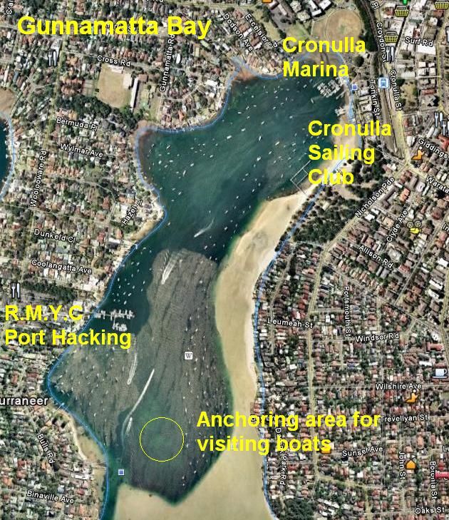
Port Hacking Cruising Group
Wattamolla
Lying an hour’s sail to the south, Wattamolla could easily be mistaken for a south sea paradise. Then
again, that’s precisely what it is; or at least a glimpse of what the area looked like pre-European
colonisation. After negotiating the three reefs, Wattamolla (also known as Providential Cove) opens up
into a beautiful lagoon complete with waterfall. The Aboriginal meaning of Wattamolla is ‘place near
running water’.

Bass and Flinders were pushed into the inlet by a violent storm and soon found themselves sheltered
in the lagoon, no doubt very happy about their lucky find and the providence that brought them there.

Jibbon Beach
On the south side and near the mouth of Port Hacking lies Jibbon Beach, a popular day and overnight
anchorage adjacent to the township of Bundeena. Jibbon Beach is great for snorkelling and the beach
is popular.

Audley Weir
There’s plenty of water under the keel at Audley itself, however, caution is required when making your
way there up the Hacking River. Be careful to stay within the green and red channel markers as there
are sandbanks and jagged oyster-encrusted rocks. Particularly between Grays Point and Swallow Rock
which can get quite shallow. But there are plenty of points of interest on the way up, especially at high
tide when dropping the dinghy in at Muddy Creek makes for a great excursion up its winding route into
the heart of the Royal National Park.
Great for bird watching and exploring.

The anchorage is snug but accommodates several boats easily.

Drop the anchor just before the weir at Pool Flats and back towards the shore then run a stern line to
shore with the dinghy. Do not attach lines to trees.

There is a floating pontoon at Pool Flats to drop of crew or to land in a dingy.

Audley is the oldest area in the Royal National Park developed for recreational purposes and has been
popular for Sydneysiders for over a century. The dance hall, pavilion, boat shed, and ornamental trees
offer a step back in time.

The Dance hall and pavilion have been recently upgraded and provide an excellent café with first class
seating in a well-equipped information area operated by the National Parks. Or you can sit on well-
manicured lawns or use the covered tables provided to watch the rental row boats bob past.

Lady Carrington drive, an early carriageway, also begins at Audley. Closed to motor vehicles, it makes
for a nice walk or cycle along the river if you’ve taken the foldaway bike. So, as you can see there’s
many ways to enjoy the beautiful surrounds that make up Port Hacking.

There’s also northwest and southwest Arm. They are great anchorages with high sides sheltering them
from the wind.

Further information

The charts of the area are AUS 198: Botany Bay and Port Hacking and AUS 197: Approaches to Port
Jackson and Port Hacking to The Skillion.

Further information can also be obtained from the Royal Motor Yacht Club on 9523 9300 or John Barter
on 0418 253 479.

Broadwater Yacht Club                                                              Date: December 2015
                                            Page 6 of 98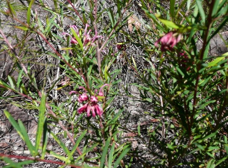
Port Hacking Cruising Division
History of Port Hacking, NSW

              Tom Thumb II voyage with George Bass
         Matthew Flinders undertook his second voyage of expedition with George Bass in March 1796, in the
         second Tom Thumb. William Martin also shared this adventure with them. This trip by sailing out of Port
         Jackson (Sydney Harbour) into the open sea, in their tiny boat, a prospect that would frighten many sailors
         of today. A current then carried their boat southwards, much further than expected. They ran short of
water and their equipment became wet while approaching shore. The encounter with aborigines at Lake Illawarra
was not without risk, but with some good humour and quick thinking, they escaped from a potentially dangerous
situation. While Flinders distracted the men by cutting their hair and beards with his scissors, Bass dried out their
wet provisions, including the gun powder. They then headed through the channel to the sea as rapidly as their
vessel could carry them.

Upon their return northwards from Lake Illawarra in Tom Thumb II, a violent storm at night almost destroyed the
open boat and its crew of three, but luck permitted them to ride to shelter in one of the few safe places along the
rugged coast, Wattamolla Beach (Providential Cove). The next day they explored the beach there, and then
sailed north to their intended destination, Port Hacking, taking soundings at the entrance. Tom Thumb arrived
back at Port Jackson seven days after leaving.

Flinders mentions his association with George Bass very positively. Together, they formed an impressive
exploration team ... (see following)

           'In Mr George Bass,
        surgeon of the Reliance, I
        had the happiness to find a
man whose ardour for discovery was
not to be repressed by any obstacle,
nor deterred by danger; and with
this friend a determination was
formed      of     completing     the
examination of the east coast of
New South Wales, by all such
opportunities as the duty of the ship
and procurable means could admit.'
Matthew      Flinders    in    Terra
Australis
                                                Bass and Flinders Point, northern side of Port Hacking looking
                                                north towards Sydney - the distant cliff is Point Solander.

         The area is made up of the sandstones that outcrop frequently in the Sydney region. The port, because
       of its sheltered nature, is protected from the high energy waves that strike the shore along the exposed
       coastline outside. Thus, while platforms and cliffs are present, they are not as strongly developed as
elsewhere along the Sydney coast.

The sandstone mass of the coastal area was gently pushed up to form a plateau of several hundred metres
elevation some millions of years ago. Erosion by a small river carved a gorge into the plateau at this site, cutting
down to the lower sea level of the glacial era. As sea level rose after the glacial, the valley became a bay.

In general, the soils developed on sandstone are of low fertility. However, they are able to support a considerable
variety of native vegetation that has developed upon them.

Date: December 2015                                                                  Broadwater Yacht Club
                                               Page 7 of 98
Port Hacking Cruising Group
Fire and landscape change

An interesting point is the identification of fire as
one of the processes involved in landform change
in sandstone areas of the Sydney Basin. Fire kills
grass, exposing soil to removal by rain. Fire
passing over an area also heats rock, causing
fragments to flake off the surface. Less frequently,
but also importantly, tree trunks smoulder on the
ground for several days, causing a deeper
weakening of the rock below.

                                                                     Soil and rock on sandstone, exposed after fire

        Royal National Park
On the southern side of Port Hacking,
next to the village of Bundeena, is the
beaches and forested slopes of Royal
National Park (see photo below). This
national park was the first such
protected area in Australia, and only the
second such area in the world. In hot,
dry periods fire is a risk within the
eucalypt forests of the Sydney region.

                                                          Port Hacking, looking inland, viewed from northern side
Exploring Port Hacking...

        'Was employed in the examination of the port ... The shores of the port are mostly rocky;
particularly on the north side; but there is no want of grass or wood ... streams which descend, apparently
from the inland mountains, into the uppermost branch ... After sounding the entrance of Port Hacking in
going out, and finding 3 1/2 fathoms of water, we steered NE by E for Cape Solander ... '
- Matthew Flinders in Terra Australis,             Memorials at Bass and Flinders Point, Port Hacking, NSW
1 Apr 1796

                                                                  Bass and Flinders memorial
Port Hacking – Name by Mathew Flinders in 1796. First fleet pilot Henry Hacking had told him of rumours of a
large river south of Botany Bay. Originally named Port Aiken (alternatively Akin or Aken) after midshipmen John
Aicken, First Fleet, who discovered the river. Port Hacking heads were known as ‘Port Aiken Heads’ in 1780

                                                  .Return to Index

Broadwater Yacht Club                                                                   Date: December 2015
                                                 Page 8 of 98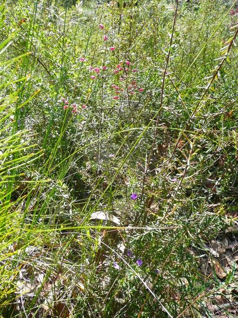
Port Hacking Cruising Division
About Port Hacking
Port Hacking is often referred to as Sydney's forgotten waterway. This pristine waterway is located in the
Sutherland Shire in Sydney's south. Port Hacking is much smaller than Sydney’s other major waterways, however
it is also credited as being the least polluted. Just five minutes out of any of the ports ramps or marinas and you
can be completely surrounded by the Royal National Park, without a hint of civilization in sight.
It is possible to travel across Port Hacking to Bundeena, aboard the Cronulla Ferries vessel
"Curronulla" which is the oldest working ferry in Australia. Cronulla Ferries also offer lunch
and tea cruises of Port Hacking aboard the "Tom Thumb III". Many of the people who go
boating in Port Hacking return time and again to enjoy this magnificent waterway many
wonders. There are numerous charter fishing vessels, commercial cruise vessels and diving
charter vessels operating out of Port Hacking. Port Hacking and the Coastline of the Royal
National Park offer some of the best diving locations in the greater Sydney area. Off the coast
of Port Hacking and the Royal National Park there are numerous reefs and wrecks which are a haven for all forms
of marine life and the fishermen they attract. Fishing inside the port is only permitted for amateur fishermen. Spear
and spear gun fishing are both strictly forbidden inside Port Hacking as it is part of the Royal National Park.
                      Port Hacking is a majestic waterway, but it is not without its hazards. Large areas of the port
                      are very shallow, and it is highly important that all vessels stay within the marked channels.
                      Many of Port Hacking's notorious sand bars are covered with a rare and protected species of
                      sea grass. This sea grass adds an additional concern for the Coast Guard as we must limit
                      any damage to the grass when freeing wayward vessels from the sandbars. The Coast Line
                      of the Royal National Part and the Kurnell Peninsula are both beautiful, with their high cliffs
and hidden inlets, and very dangerous, with numerous reefs and bomboras. Every year numerous lives are lost
along this short stretch of coastline, both from people on the coast and in vessels. There are many wrecks along
this coast from vessels that didn't survive their voyage.
Port Hacking is best known for the Surf Beaches at Cronulla. The Beaches of Cronulla,
North Cronulla, Wanda and Eloura are considered to have some of the best surf in
Sydney. These beaches are covered with people in the summer months, both swimmers
and surfers. The more adventurous surfers tend to head for places such as Boat Harbour
on the Kurnell peninsula, and the aptly named Shark Island. Shark Island is also very popular with divers and
fishermen due to the large amount of marine life. The Cronulla Peninsula south of Cronulla Beach is well known
as one of the best place for seeing the very rare and endangered Eastern Sea Horse. The Cronulla foreshore is
also home to over a dozen different species of sharks and most dangerously of all, the highly poisonous, Blue
Ringed Octopus, can be found here in large numbers. However, with the development of anti-venom for the Blue
Ringed Octopus deaths from Blue Ring bites has drop to Zero with only a few people being hospitalized for longer
than overnight.
In 1994, Port Hacking saw its largest emergency to date, when the Royal National Park and
                     surrounding Areas were engulfed by fire. These fires raged for over two
                     weeks and required the complete evacuation of the Royal National Park
                     including the townships of Bundeena and Maianbar, over 5,000 people
                     in total. As well as the evacuations, fire fighters in the Royal National
                     Park required all support to be done by vessel, as all roads in and out
of the park were completely cut-off by fire. The evacuation and support operations were commanded and control
by the Botany Bay Water Police and involved at some point every commercial vessel on Port Hacking, and almost
100 private vessels were also involved. All operations were performed in a near flawless manner without a single
serious injury or property damage.
Even with extensive use of aircraft and helicopters to water bomb the fire, it was not brought under control until a
                       major sustained change in the wind direction occurred. During these fires not a single
                       house was lost in the townships of Bundeena or Maianbar, and only one fire fighter lost
                       his life when a tree collapsed on his tanker truck during clean-up operations after the fire.
                       The Royal National Park will never recover from the environmental damage caused in
                       these fires. It is expected that wildlife within the park will take over 10 years to return to
                       the numbers prior to these fires. Whilst there is still clear evidence of the fires much of
                       the native flora has re-grown and the park is slowly recovering.

Date: December 2015                                                                  Broadwater Yacht Club
                                               Page 9 of 98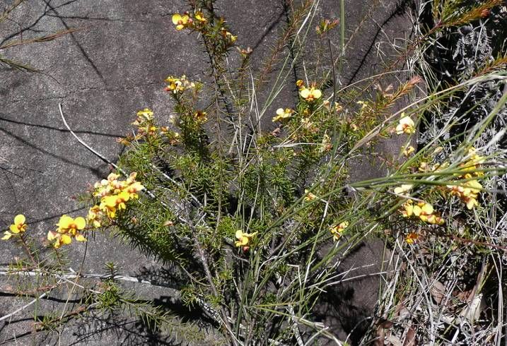
Port Hacking Cruising Group
The Story of Trim
Matthew Flinders literally put Australia on the map, but he didn't do it alone — he was helped
by a cat called Trim.

Trim was born in 1799 on board HMAS Reliance on Flinders' voyage from the Cape of Good Hope to
Botany Bay.

He was an adventurous spirit from the beginning; early on Trim fell overboard and had to swim to the
boat and climb up a rope to safety.
Rachel Franks from the State Library of NSW said it was this act of bravery that caught Flinders'
attention.

"I think that he always had that determination," she told Sarah Macdonald on ABC Radio's Nightlife.
"I think Matthew quite liked his spirit and I think Trim quite liked [Flinders] as well."
Flinders gave the small black and white cat the name Trim after the butler in Laurence Sterne's book
Tristram Shandy.

He described his feline friend as:
"One of the finest animals I ever saw ... [his] robe was a clear jet black, with the exception of his four
feet, which seemed to have been dipped in snow, and his under lip, which rivalled them in whiteness.
He had also a white star on his breast."
When Flinders undertook a mission to circumnavigate the southern continent in the ship Investigator,
Trim was by his side.

Trim was said to be a cheeky cat, who would join the captain at his table and try to swipe food off the
forks of others as they ate.

"He only stole food once," Ms Franks said.
"Apparently there was a large piece of mutton that was a bit too tempting and he teamed up with
another cat — they didn't get very far."
The adventures of Trim

Listen as Rachel Franks from the State
Library of NSW tells the story of Trim on
Nightlife.

Trim would not have been the only cat on
board Investigator; most ships kept a few
cats onboard to catch rats and mice that
could cause havoc by eating supplies or gnawing on ropes.

But Trim's personality appears to have been bigger than the other ship cats.
Flinders even wrote a biography for his constant cat companion as well as other tributes and poems.

Broadwater Yacht Club                                                            Date: December 2015
                                            Page 10 of 98
Port Hacking Cruising Division
Shipwrecked and imprisoned
Trim was with Flinders when he was shipwrecked on the Great Barrier Reef.
They were trying to return to England on HMS Porpoise when they ran aground and the crew,
including Trim, had to swim to safety on a small island.
Trim was said to have helped keep the stranded men's spirits up while they waited seven weeks for
rescue.
Mapping of Australia
The name Australia was made popular by
Matthew Flinders, who literally put the entire
country on the map.
And this was not to be the last of Trim's
adventures; he again took to the high seas
with Flinders as they tried to get back to
England.
Flinders made a stop at the French colony on Mauritius, needing repairs and supplies to continue.
But as France and England were at war, Flinders was detained by the island's governor for six-and-a-
half years under house arrest.
Trim stayed with Flinders the whole time — but he was allowed to wander the island.
During one of his outdoor explorations in 1804, the cat failed to return, much to the distress of
Flinders.
He believed Trim had been eaten by a hungry slave, but this was never proven.
Flinders wrote about the demise of his friend:
"Thus, perished my faithful intelligent Trim! The sporting, affectionate and useful companion of my
voyages for four years.
"Never, my Trim, 'to take thee all in all, shall I see thy like again', but never wilt thou cease to be
regretted by all who had the pleasure of knowing thee.
"And for thy affectionate master and friend, he promises thee, if ever he shall have the happiness to
enjoy repose in his native country, under a thatched cottage surrounded by half an acre of land, to
erect in the most retired corner a monument to perpetuate thy memory and record thy uncommon
merits."
Flinders never got a chance to erect a monument to Trim, but four statues now stand as memorials to
the adventurous cat — two in England, two in Australia — and his story lives on.
Date: December 2015 Broadwater Yacht Club
Page 11 of 98Port Hacking Cruising Group
Cruising contact system
The first three rules of cruising listed latter would suggest that organising dates, destinations and time can only
lead to failure. So detailed below is a system to co-ordinate and notify cruising boats in way that they can be
informed of others cruising intentions and can easily make contact in an informal manner when on the waters of
Port Hacking and beyond.
This communication will take place at two levels:
First Level:
The first is via a central email address john.barter@optusnet.com.au where cruising events will be broadcast to
participating members and where members can advertise their intentions to the central email address for
broadcast so that the cruising plans of all can be co-ordinated.
Example: Spray may be planning to cruise to Sydney Harbour on a long weekend, so notifies the central email
address which broadcasts to all. A response may come in from several boats considering the same destination
at the same time.
These boats can then sail in company or locate each other in due course by the second system.
A website will also be established to permanently record the intentions of all participating boats making contact at
an individual level as well as being a method to promote organised events.
Site address: http://www.rmycph.com.au/cruising/index.html
Organised events for example may be; The Broadwater Classic, A Cruising fleet to Jervis Bay or other regular
events planned for Port Hacking.
The web can also be used to record the travels or destinations of past times and hopefully members will assist by
supplying their write-ups with pictures.
Second Level;
The second system provides a means to locate any cruising boat that is in the same location, by using a universal
call sign on VHF channel 16. The call procedure is as follows:
Hello Trim, Hello Trim, Hello Trim - This is Spray, Spray, Spray over
If you read the brief history in the introduction you would know that Trim was Flinders cat. Any boat (let’s say) on
the Port will recognise this call as coming from another cruising boat looking for company. It is not mandatory to
answer if you want to maintain your privacy, but if you wish to make contact you can reply on channel 16 using
your call sign and change to VHF 73 to discuss details.
This system can be used to identify cruising boats in range wherever they may be.
A possible scenario may be; it is a nice summers Sunday and you decide to head to the boat to find a sheltered
anchorage for lunch. You have no idea who else may be on the Port so you call Trim on VHF 16. You find there
are several other boats with like intension at Darks Bay so you can now enjoy your lunch with the fellowship of
others.
To further compliment this system a flag will be issued which has a Yellow background and a black Trim (cat) for
you to fly from the lower crosstrees to identify your position on the water and an identifying badge to help new
members to meet the older members at meetings of the water.
A Port Hacking Cruising Guide will be available (with the assistance of the cruising members and the onshore
meetings) to cruising members or for visiting boats to join into the system.
Broadwater Yacht Club Date: December 2015
Page 12 of 98Port Hacking Cruising Division
Clubs, Marinas and Fuel
Royal Motor Yacht Club - Port Hacking
Address: 228 Woolooware South Road,
Cronulla 2230
Calling: VHF Channel 77
Phone: (02) 9523 9300
Email: info@rmycph.com.au
Website: http://www.rmycph.com.au/home/
Location: Western Shore Gunnamatta Bay
Landing: Marina
Fuel: Diesel and Petrol not available
Berthing: Marina
Moorings: Yes
Cronulla Sailing Club Ltd
Address: 1 Waratah Street, Cronulla 2230
Calling: No
Phone: (02) 9523 6114
Email: cscmail@optusnet.com.au
Website: www.cronullasc.yachting.org.au
Location: Northern Shore Gunnamatta Bay
Landing: Wharf with limited access
Fuel: No
Marina: No
Moorings: No
Yowie Bay Marina
Address: 1 Wonga Road Yowie Bay, NSW 2228
Calling: No
Phone: Ph: (02) 9524 3621 Fax: (02) 9524 1310
Website: http://www.andrewshortmarine.com.au
Location: Western Shore of Yowie Bay
Landing: Yowie Bay Marina is by appointment only.
For all details or to make an appointment
please contact 9524 3621.
Fuel: No
Marina Berths: The facility also includes slipways and a
number of berths which may be rented.
Port Hacking Open Sailing Club
Address: 226B Attunga Rd Yowie Bay NSW 1490
Calling:
Phone: 02 9526 1506
Email: tcolin@optusnet.com.au
Website: http://www.yachting.org.au/db/clubdisplay.asp?ID=2073&Action=Display
Location: Western Shore Yowie Bay
Landing: Wharf
Fuel: No
Marina Berths: No
Information: PHOSC is a family orientated club catering to all grades and ages of dinghy sailor. We
have numerous social activities throughout the year!!New members welcome. Major
racing classes catered for include MJ's, Flying 11's, NS's, Herons and Sharpies.
Date: December 2015 Broadwater Yacht Club
Page 13 of 98Port Hacking Cruising Group
Cronulla Marina
Address: 2 Tonkin St Cronulla 2230
Calling:
Phone: 9544 0888 Mobile: 0419 188 850
Email:
Web: http://cronullamarina.boatpoint.ninemsn.com.au/
Location: Northern Shore Gunnamatta Bay
Landing: Marina
Fuel: Diesel and Petrol
Marina Berths: Yes
Moorings: Yes
Hire boats: 3 metre aluminium dinghies
Dolans Bay Marina Pty Ltd
Address: 72 -74 Parthenia St Dolans Bay 2229
Calling:
Phone: (02) 9526 1070
Email: lbcronulla@bigpond.com
Website:http://www.leisureboating.com.au/Clubs/Cronulla/Location.asp?SessionID=
Location: Western Shore of Dolans Bay
Landing: Marina
Fuel: NIL
Marina Berths: Yes
Moorings: Yes
Hire boats:
Burraneer Bay Marina
Address: 48 Fernleigh Rd Caringbah 2229
Calling:
Phone: (02) 9523 5250
Email: Erin@burraneerbaymarina.com.au
Website: http://www.burraneerbaymarina.com.au/
Location: Western Shore of Burraneer Bay
Landing: Marina
Fuel: Diesel and Petrol
Marina Berths: Yes
Moorings: Yes
Hire boats:
Broadwater Yacht Club Date: December 2015
Page 14 of 98Port Hacking Cruising Division
The Channels of the Port (October 2021)
Date: December 2015 Broadwater Yacht Club
Page 15 of 98Port Hacking Cruising Group
Broadwater Yacht Club Date: December 2015
Page 16 of 98Port Hacking Cruising Division
Map of Port Hacking
Date: December 2015 Broadwater Yacht Club
Page 17 of 98Port Hacking Cruising Group
Radio coverage frequencies repeaters etc
Marine Radio
With the closure of the six local Coast Radio Stations, they were replaced by two TVNZ (A) maritime
communication stations (licensed by the ACA as Major Coast Stations. These stations operate from Willuna
WA and Charleville Qld. (Call sign "RCC Australia"). There is no longer routine or public correspondence
available through the maritime communication stations.
Vessels without DSC or Inmarsat equipment will not be able to contact maritime communication stations. The
"Major Coast Stations" only monitor DSC - 4MHz & upwards. As of February 1999, DSC (Digital Selective
Calling) was introduced to the MROCP & MROVCP certificates. (Marine Radio Operators Certificate & Marine
Radio Operators VHF Certificate of Proficiency). Whilst holders of the former certificate RROCP and the earlier
3rd Class Commercial Operators Certificate of Proficiency will continue to be legally qualified even though their
radio communications equipment may incorporate DSC facilities. However such persons will need lo
additionally qualify for the Marine Satellite Communications Endorsement if operating Inmarsat types A, B or C
equipment.
AVCG - Coast Guard Sydney organize 4 Radio courses per year and we could arrange a DSC update to current
holders of RROCP if requested.
DSC (Digital Selective Calling)
• Is available only on MF/HF & VHF - not available on 27MIIz.
• Is a brief burst (typically seven seconds on MF/HF, and 0.5 second on VHF) of digitised information
transmitted from one station to alert another station or stations, and to provide some basic
information.(excluding alert durations).
• Frequencies have been internationally allocated in the MF/HK and VHF marine
bands for DSC distress, urgency and safety alerts.
• For routine DSC communication an MMS1 no. (Maritime Mobile Service Identity) is required.
• Steps to transmit a DSC distress Alert and subsequent distress call and message
Select DSC » Initiate DSC » Change to Associated » Transmit Radiotelephony
channel Distress Alert radiotelephony channel Distress call & message
MF/HF
• AM (H3E) & SSB (J3E) - 2 to 22 MHz bands - long distant communications.
• 2MHz band uses ground wave, 4 to 22 MHz uses Sky waves ‘Ionosphere’.
• 2182 uses AM all other frequencies SSB.
• Safety service provided by Limited Coast Stations
• Offers communications range of many thousands of miles and worldwide given the correct choice of
frequency band
• Disadvantage — subject lo interference from atmospheric conditions, ignition etc, high cost, complex
installation & greater operator expertise.
• Radphone has been discontinued.
• DSC available
VHF
• Operates on FM
• Offers line of sight communication - up to 20 klm ( 1 0 . 8 nautical miles) and between vessel and
shore of 50 klm (27 nautical miles), possibly significantly greater.
• a safety service provided by Limited Coast Stations operated by Marine Rescue and other
organisations.
• Relative inexpensive, highest quality signals, suffering least from interference caused by atmospheric
or ignition sources.
• Repeater services available.
• Disadvantage of suffering blind spots behind cliffs, sand hills and heavy vegetation.
• DSC available.
• All operators are reminded that, although VHF apparatus is subject to a CLASS licence the operator
must hold at least a MRO VCP. AC A is pursuing the unlicensed.
Broadwater Yacht Club Date: December 2015
Page 18 of 98Port Hacking Cruising Division
27 MHz
• A communications range, under favourable conditions, of between 10 & 50 klm (5.4 and 27 nautical
miles)
• Safety service provided by limited Coast Stations operated by marine rescue organisations.
• Advantages of being cheap and easy to install; but the disadvantages of being subject to interference
from atmospheric and ignition noise (and on occasions, from distant radio stations) and of not
providing access to a radiotelephone service.
• Despite the disadvantages, 27 MHz marine equipment is ideal for small vessels which operate
inshore and within range of limited coast stations operated by marine rescue organisations.
LOG ON
• Ship station operators are encouraged to provide departure, positional and arrival information to a
maritime communication station, coast radio station or limited coast station operated by marine rescue
organisations,
• VMR SYDNEY SOUTH maintains a 24 hour radio base in the Old Signal Station at Vaucluse.
• Coast Guard Sydney offers an Associate Membership which records relevant details on computer
with an Eagle November Alpha No. (ENA 123 ) and weather bureau updates 10 minutes to the odd
hour- more often as the weather turns foul
• Vessels proceeding up or down the coast are advised to familiarise themselves with the various
Volunteer organisations operating the rescue bases as not all are 24hour.
Weather
The Bureau of Meteorology provides automatically generated radiotelephony broadcasts of routine weather forecasts
and weather warnings through the maritime communication stations. These frequencies are not monitored and should not
be used for routine radiotelephony. Full details are available on the Bureau of meteorology website:
www.bom.gov.au/marine
• MF/HF frequencies - 2201 & 4426 khz (automatically transmitted) (0503 & 1703hrs) Warnings 3min
past odd hour
• Coastal forecasts 5min to the hour 0130 + 4hourly EST- warnings on the hour. (BOM)
• VHF frequency - 67 @ 0733 & 1733 - severe warnings hourly intervals. 13 (Harbour Control) -usually
3min past the hour
• Coast Guard Sydney relays the Weather Bureaus forecast and local sea conditions -10 minutes to the
odd hour from 0500 to 2200 daily on 27.88/86, VHF 16/67.
Medical
In urgent cases, a DSC urgency alert may be used to establish communications with the marine communication station
who have formal arrangements with health authorities and will relay medical advice to and from vessels at sea in
an emergency. This service is free of charge.
Note
Radio checks or calls of a general nature should be directed to volunteer marine rescue groups or other service
providers.
Coast Radio stations are no longer required to constantly monitor 2182 kHz.
Eastern 'Coast Radio Station' call signs-
COAST RADIO CAIRNS
COAST RADIO GLADSTONE
COAST RADIO SYDNEY
COAST RADIO MELBOURNE
COAST RADIO HOBART
Coast Guard Sydney radio tower phone no.9337.5033
Facsimile 9337.5251
Frequencies monitored- 27.88 & 86
VHF-16, 67 and 73
MF/HF- 2182,2524,4125,6215
(Others by arrangement)
Bob Foster
Coast Guard Sydney 9484.7870
Date: December 2015 Broadwater Yacht Club
Page 19 of 98Port Hacking Cruising Group
Volunteer Marine Rescue – NSW Bases
Marine Rescue Point Danger – : 07 5536 9333 : 0409 249 993 : 07 5536 3825 Rescue vessel
e-email: pointdanger@marinerescuensw.com.au Latitude: 28° 9' 54.155"S Longitude: 153° 33' 3.061"E
Marine Rescue Brunswick – : 02 6685 0148 : 0488 304 343 : 02 6685 0253 Rescue vessel
e-mail: brunswick@marinerescuensw.com.au Latitude: 28° 32' 7.408"S Longitude: 153° 32' 43.315"E
Marine Rescue Byron Bay – : 02 6680 8417 : 0488 288 018 : 02 6685 5121 Radio base only
e-mail: capebyron@marinerescue.com.au Latitude: 28° 38' 6.644"S Longitude: 153° 38' 13.163"E
Marine Rescue Ballina – . 02 6681 4700 : 0437 423 797 : 02 6686 4355 Rescue vessel
e-mail: base.ballina@marinerescuensw.com.au Latitude: 29° 53' 12.17"S Longitude: 153° 15' 59.864"E
Marine Rescue Evans Head – : 02 6682 4888 : 0409 155 622 : 02 6682 5088 Rescue Vessel
e-mail: evanshead@marinerescuensw.com.au Latitude: 29° 6' 54.494"S Longitude: 153° 26' 21.668"E
Marine Rescue Iluka/Yamba – : 02 6646 6311 : 0400 577 982 : 02 6646 6785 Rescue vessel
e-mail: ilukyayamba@marinerescuensw.com.au Latitude: 29° 25' 21.287"S Longitude: 153° 21' 32.081"E
Marine Rescue Wooli – : nil : 0437 423 797 : 02 6649 7090 Rescue vessel
e-mail: wooli@marinerescuensw.com.au Latitude: 29° 53' 12.17"S Longitude: 153° 15' 59.864"E
Marine Rescue Woolgoolga – : 02 6654 1785 : 0417 403 520 : 02 6654 9759 Rescue vessel
e-mail: woolgoolga@marinerescuensw.com.au Latitude: 30° 6' 34.82"S Longitude: 153° 12' 8.616"E
Marine Rescue Coffs Harbour – : 02 6652 3155 : 0435 945 848 : 02 6651 2257 Rescue vessel
e-mail: coffsharbour@marinerescuensw.com.au Latitude: 30° 18' 34.74"S Longitude: 153° 8' 7.323"E
Marine Rescue Nambucca – : 02 6568 4204 : 0427 105 040 : 02 6568 3325 Rescue Vessel
e-mail: nambucca@marinerescuensw.com.au Latitude: 30° 38' 42.361"S Longitude: 153° 0' 22.119"E
Marine Rescue Trial Bay – : 02 6566 5240 : 0488 690 723 : 02 6566 7966 Rescue Vessel
e-mail: trialbay@marinerescuensw.com.au Latitude: 30° 52' 59.847"S Longitude: 153° 2' 29.423"E
Marine Rescue Port Macquarie – : 02 6584 1966 : 0419 999 451 : 02 6583 8211 Rescue Vessel
e-mail: portmacquarie@marinerescuensw.com.au Latitude: 31° 25' 48.493"S Longitude: 152° 55' 14.635"E
Marine Rescue Camden Haven – : 02 6559 7356 : 0412 904 389 : 02 6559 5324 Rescue Vessel
e-mail: camdenhaven@marinerescuensw.com.au Latitude: 31° 38' 54.409"S Longitude: 152° 48' 6.374"E
Marine Rescue Crowdy Harrington – : 02 6556 1564 : 0409 912 590 : 02 6556 1830 R-Vessel
e-mail: crowdyharrington@marinerescuensw.com.au Latitude: 31° 52' 21.717"S Longitude: 152° 41' 28.877"E
Broadwater Yacht Club Date: December 2015
Page 20 of 98Port Hacking Cruising Division
Marine Rescue Forster Tuncurry – : 02 6554 5458 : 0404 846 039 : 02 65545 8040 Vessel
e-mail: base.forstertuncurry@marinerescuensw.com.au Lat: 32° 10' 31.689"S Long: 152° 30' 32.736"E
Marine Rescue Nelson Bay - : 02 4981 3585 : 0407 498 135 : 02 4984 1944 Rescue Vessel
e-mail: nelsonbay@marinerescuensw.com.au Latitude: 32° 42' 37.899"S Longitude: 152° 9' 41.059"E
Marine Rescue Lemon Tree Passage – : 02 4982 4981 : nil : 02 4984 5537 Rescue Vessel
e-mail: lemontreepassage@marinerescuensw.com.au Latitude: 32° 43' 37.203"S Longitude: 152° 1' 45.411"E
Marine Rescue Newcastle – : 02 4927 8237 : 0487 922 670 or 0439 980 995 : 02 4927 8238
e-mail: newcastle@marinerescuensw.com.au Latitude: 32° 56' 9.268"S Longitude: 151° 46' 41.45"E Vessel
Marine Rescue Lake Macquarie – : 02 4971 3498 : 0430 521 510 : 02 4972 1088 Rescue Vessel
e-mail: lakemaquarie@marinerescuensw.com.au Web site: marinerescuelakemaquarie.com.au
Latitude: 33° 5' 17.078"S Longitude: 151° 39' 51.84"E
Marine Rescue Toukley – : 02 4396 5899 : 0414 460 436 : 02 4390 9995 Rescue Vessel
e-mail: toukley@marinerescuensw.com.au Latitude: 33° 15' 33.789"S Longitude: 151° 32' 32.484"E
Marine Rescue Norah Head – : 02 4396 6162 : nil : 02 4396 6124 Rescue Vessel
e-mail: norahhead@marinerescuensw.com.au Latitude: 33° 16' 45.46"S Longitude: 151° 34' 3.738"E
Marine Rescue The Entrance – : 02 4332 3055 : 0488 442 051 : 02 4332 3055 Rescue Vessel
e-mail: theentrance@marinerescuensw.com.au Latitude: 33° 20' 3.358"S Longitude: 151° 30' 12.154"E
Marine Rescue Terrigal – : 02 4384 3606 : 0418 433 747 : 02 4384 2677 Rescue Vessel
e-mail: terrigal@marinerescuensw.com.au Latitude: 33° 26' 50.163"S Longitude: 151° 27' 1.951"E
Marine Rescue Central Coast – : 02 4325 7929 : 0402099042 : 02 4325 1806 Rescue Vessel
e-Mail: centralcoast@marinerescuensw.com.au Latitude: 33° 26' 18.531"S Longitude: 151° 19' 53.753"E
Marine Rescue Hawkesbury : 02 9985 9012 : 0429 499 060 : 02 9985 9132 Rescue Vessel
e-mail: hawkesbury@marinerescuensw.com.au Latitude: 33° 31' 43.706"S Longitude: 151° 12' 5.575"E
Marine Rescue Cottage Point – : 02 9456 3055 : 0412 254 912 : 02 9456 5734 Rescue Vessel
e-mail: cottagepoint@marinerescuensw.com.au Latitude: 33° 36' 55.942"S Longitude: 151° 12' 26.364"E
Marine Rescue Broken Bay – : 02 9999 3554 : 0425? : 02 9997 5849 Rescue Vessel
e-mail: brokenbay@marinerescuensw.com.au Web: marinnerescuebrokenbay.org.au
Latitude: 33° 39' 47.15"S Longitude: 151° 18' 9.38"E
Marine Rescue Terrey Hills – : 02 9450 2468 : 0423 328 377 : 02 9486 3486 Rescue vessel
e-mail: sydney@marinerescuensw.com.au Latitude: 33° 39' 47.15"S Longitude: 151° 13' 20.65"E
Marine Rescue Middle Harbour – : 02 9969 3270 : 0412 018 264 : 02 9969 8346 Rescue Vessel
e-mail: middleharbour@marinerescuensw.com.au Latitude: 33° 48' 20.897"S Longitude: 151° 14' 48.645"E
Date: December 2015 Broadwater Yacht Club
Page 21 of 98Port Hacking Cruising Group
Marine Rescue South Head (Port Jackson) – 02 9337 5033 0408 688 950 02 9337 5251 R-Vessel
e-mail: portjackson@marinerescuensw.com.au Latitude: 33° 51' 22"S Longitude: 151° 09' 47.5"E
Marine Rescue Botany Bay – : 02 9668 9888 : 0419 622 770 : nil Rescue Vessel
e-mail: botanybay@marinerescuensw.com.au
Marine Rescue Solander (Port Hacking) – : 02 9668 9888 : 0418 545 199 : ? Rescue Vessel
e-mail: porthacking@marinerescuensw.com.au Latitude: 34° 03' 44.8"S Longitude: 151° 07' 37.5"E
Marine Rescue Port Kembla – : 02 4274 4455 : 0458 577 819 F: 02 4274 4288 Rescue Vessel
e-mail: portkembla@marinerescuensw.com.au Latitude: 34° 29' 31.328"S Longitude: 150° 55' 0.007"E
Marine Rescue Shellharbour : 02 4297 3999 : 0447 722 667 : 02 4297 3999 Rescue Vessel
e-mail: shellharbour@marinerescuensw.com.au Latitude: 34° 34' 33.614"S Longitude: 150° 52' 15.131"E
Marine Rescue Shoalhaven : 02 4447 4466 : 0488 444 555 : 02 4447 4067 Rescue Vessel
e-mail: shoalhaven@marinerescuensw.com.au Web site: http://www.shoalrescue.com.au
Latitude: 34° 54' 8.204"S Longitude: 150° 46' 3.937"E
Marine Rescue Jervis Bay – : 02 4447 5433 : 0402 079 838 : 02 4443 3887 Rescue Vessel
e-mail: jervisbay@marinerescuensw.com.au Latitude: 35° 2' 17.03"S Longitude: 150° 40' 21"E
Marine Rescue Sussex Inlet – : 02 4441 3555 : 0412 811979 : 02 4441 1444 Rescue Vessel
e-mail: sussexinlet@marinerescuensw.com.au Latitude: 35° 21' 30.41"S Longitude: 35° 21' 30.41"E
Marine Rescue Ulladulla – : 02 4455 3403 : 0414 296 367 : 02 4455 1861 Rescue Vessel
e-mail: ulladulla@marinerescuensw.com.au Latitude: 35° 21' 30.41"S Longitude: 150° 28' 21.39.54"E
Marine Rescue Kioloa – : 02 4457 1109 : 0459 097 849 : 02 4457 1109 Rescue Vessel
e-mail: kioloa@marinerescuensw.com.au Latitude: 35° 33' 50.5"S Longitude: 150° 23' 01.4"E
Marine Rescue Batemans Bay – : 02 4472 3060 : 0488 723 070 : 02 4472 3060 Rescue Vessel
e-mail: batemansbay@marinerescuensw.com.au Latitude: 35° 43' 07.48"S Longitude: 150° 11' 48.09"E
Marine Rescue Tuross - : 02 4473 8111 : 0407 260 231 : 02 4472 8115 Rescue Vessel
e-mail: tuross@marinerescuensw.com.au Latitude: 36° 3' 49"S Longitude: 150° 7' 24"E
Marine Rescue Narooma – : 02 4476 1443 : 0410 094 443 : 02 4476 3228 Rescue Vessel
e-mail: narooma@marinerescuensw.com.au Latitude: 36° 12' 51.14"S Longitude: 150° 8' 8.21"E
Marine Rescue Bermagui – : 02 6493 4506 : 0429 494 100 : 02 6493 4304 Rescue Vessel
e-mail: bermagui@marinerescuensw.com.au Latitude: 36° 25' 31.9"S Longitude: 150° 4' 13.53"E
Marine Rescue Merimbula – : 02 6495 3331 : nil : 6495 3027 Rescue Vessel
e-mail: merimbula@marinerescuensw.com.au Latitude: 36° 53' 18.18"S Longitude: 149° 55' 7.38"E
Marine Rescue Eden – : 02 6496 2167 : 0421 646 535 : 02 6496 3589 Radio Base
e-mail: eden@marinerescuensw.com.au Longitude: 37° 4' 29.96"S Longitude: 149° 54' 50.43"E
Broadwater Yacht Club Date: December 2015
Page 22 of 98Port Hacking Cruising Division
Important Telephone Numbers - All Emergencies only Phone 000
WATER POLICE Royal Motor Yacht Club (Port Hacking)........ 9523 9300
Sydney Harbour ....................................... 9692 5411
Cronulla Sailing Club ........................................ 9523 6144
Botany Bay.............................................. 8566 7566
Broken Bay ............................................. 9979 4044
Newcastle ............................................... 4902 8230 TELEPHONE WEATHER SERVICES
Port Stephens .......................................... 4984 9012 Sydney Metropolitan Service .............. 1900 926 100
Coffs Harbour.......................................... 6652 0257 NSW Coastal Waters Service .............. 1900 926 101
Port Kembla ............................................ 4276 5180 Waters Service .................... 1900 969 955
Eden ........................................................ 6496 0699 Newcastle and Hunter Service ............ 1900 969 954
TELSTRA DIAL-IT WEATHER SERVICES ........... 1196
PORT EMERGENCIES
Sydney (24 Hours) .................................. 9296 4000 BOATING WEATHER BY FAX
Newcastle ............................................... 4985 8222 NSW Directory ................................... 1800 061 439
Port Kembla ............................................. 4274 4571 Listing of Voice Weather Services ........1902 935 254
WATERWAYS (Boating weather) ................ 13 12 36 Greater Sydney Forecast....................... 1902 935 222
Radar - Sydney ................................... 1902 935 749
WATERWAYS
(Recreational Boating Enquiries) ................ 13 12 56 LATEST SATELLITE PICTURES - UPDATED
FISH WATCH HOURLY
(Reporting illegal activities) ................ 1800 043 536 Australian Region................................ 1902 935 201
N.E. Australia ...................................... 1902 935 202
AUSTRALIAN MARITIME SAFETY AUTHORITY.
Maritime.............................................. 1800 641 792 WEATHER AND FORECAST CHARTS
24 Hours emergency numbers www.bom.gov.au
- SAR/ Oil Spills Aviation ................... 1800 815 257 Surface Weather (MSL analysis)............ 1902 935 201
Forecast Chart (MSL prognosis) ...........1902 935 211
Australian Swell Wave
CUSTOMS WATCH (24 Hours) ......... 1 800 061 800 Height24 & 36hr forecasts ................... 1902 935 266
Coral Sea High Seas Forecast ............. 1902 935 267
Tasman Sea High Sea Forecast ........... 1902 935 268
WHALE & SEAL RESCUE (ORRCA)......... 9415 3333 NSW Sea Surface Temperature ........... 1902 935 264
NEW SOUTH WALES- FORECASTS AND
POISONS INFORMATION CENTRE OBSERVATIONS
(24Hrs) ........................................................ 13 11 26 Coastal Waters .................................... 1902 935 220
Sydney Metropolitan ........................... 1902 935 222
Access Difficulties
DIVERS EMERGENCY SERVICES ........ 1800 088 200 Help Desk (free call) ........................... 1800 630 101
MARINE RESCUE STATIONS
Sydney ..................................................................9450 2468
Solander (Port Hacking and Botany Bay ......9668 9888
Broken Bay ..........................................................9999 3554
Cottage Point .......................................................9456 3055
Middle Harbour ...................................................9969 3270
South Head ..........................................................9337 5033
Port Kembla .........................................................4274 4455
Hawkesbury .........................................................9985 9012
GENERAL
Date: December 2015 Broadwater Yacht Club
Page 23 of 98You can also read