Depopulation and Extinction of Villages in Moravia and the Czech Part of Silesia since World War II - MDPI
←
→
Page content transcription
If your browser does not render page correctly, please read the page content below
land
Article
Depopulation and Extinction of Villages in Moravia and the
Czech Part of Silesia since World War II
Antonín Vaishar * , Hana Vavrouchová                      , Andrea Lešková and Veronika Peřinková

                                          Department of Applied and Landscape Ecology, Faculty of AgriSciences, Mendel University,
                                          Brno-sever-Černá Pole 613 00, Czech Republic; hana.vavrouchova@mendelu.cz (H.V.);
                                          andrea.leskova@mendelu.cz (A.L.); veronica.perinkova@mendelu.cz (V.P.)
                                          * Correspondence: antonin.vaishar@mendelu.cz

                                          Abstract: A thousand villages disappeared in Czechia during the course of historic development.
                                          There are two basic causes of the disappearance of villages: artificial human intervention (planned
                                          changes or hostile liquidation) and gradual depopulation due to remoteness and poor conditions for
                                          development, possibly in combination with natural disasters. The greatest number of extinct villages
                                          is related to the period after World War II, when many villages in the borderland, from which the
                                          German population was displaced, were demolished or abandoned. The aim of the article is to clarify
                                          the causes of the extinction of villages, its impact on the landscape and on the settlement system, as
                                          well as the possibilities of preserving the historical and cultural memory of extinct places. Finally,
                                          the danger of extinction of villages at the present time is discussed. This article points out that it is
                                          currently not necessary or effective to have the dense network of settlements that was present in the
                                          Middle Ages, when the population density was conditional to the limited technological potential of
                                          agriculture and transport. The main argument for preserving villages is their spiritual and cultural
                                          value, and their genius loci. However, this can be preserved without keeping the physical structure.
                                At this time, the smallest settlements are changing from being permanently inhabited, to becoming

                                          second homes sites.
Citation: Vaishar, A.; Vavrouchová,
H.; Lešková, A.; Peřinková, V.           Keywords: disappearing villages; small municipalities; expulsion of Germans; depopulation; Czechia
Depopulation and Extinction of
Villages in Moravia and the Czech Part
of Silesia since World War II. Land
2021, 10, 333. https://doi.org/           1. Introduction
10.3390/land10040333
                                               The Central European settlement system was more or less complete in the 12th–13th
                                          centuries. Its original density corresponded to the economic and transport conditions
Received: 27 February 2021
Accepted: 22 March 2021
                                          at the time. Peasants had to go to the fields, work there and return within one day.
Published: 25 March 2021
                                          This resulted in the high density of settlements in the original settlement system. In the
                                          present-day, agricultural work is mechanized and farmers commute to the fields using
Publisher’s Note: MDPI stays neutral
                                          motorized vehicles. It is no longer necessary to have the dense settlement network that
with regard to jurisdictional claims in
                                          was present in the Medieval Ages. Although conditions have changed considerably, the
published maps and institutional affil-   settlement system seems to be surviving. Tradition, local identity and nostalgia sustain
iations.                                  traditional villages.
                                               However, this is not the whole truth. Many settlements have disappeared or have
                                          been destroyed in the whirlwind of historical events. In Czech territory alone, this means
                                          approximately a thousand villages. There are two main groups of reasons in general
Copyright: © 2021 by the authors.
                                          for such development. Some villages were artificially destroyed to give way to civil
Licensee MDPI, Basel, Switzerland.
                                          engineering structures or were destroyed by wars or various catastrophes. Another large
This article is an open access article
                                          group of villages disappeared as a result of being abandoned by their inhabitants. Some
distributed under the terms and           rural settlements do not exist any more and only the remains of the foundations of the
conditions of the Creative Commons        original buildings can be seen today. Other rural settlements have been transformed
Attribution (CC BY) license (https://     into second homes, without any or only a minimum of permanent residents.
creativecommons.org/licenses/by/               During World War II, thousands of villages were destroyed in Europe. They were
4.0/).                                    destroyed during the fighting or were burned as part of Nazi terror. Some of the destroyed

Land 2021, 10, 333. https://doi.org/10.3390/land10040333                                                      https://www.mdpi.com/journal/land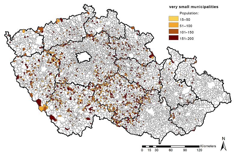
Land 2021, 10, 333                                                                                          2 of 18

                     villages were left as monuments for reverent reasons. The most famous Czech case is Lidice.
                     It can be assumed that most of the destroyed villages were restored after the war, but the
                     available literature focuses more on urban renewal. However, this issue is not the subject
                     of this article. Theoretically, it could be more about the consequences of an ethnically-
                     based population change. A significant difference in terms of memory is that places of
                     struggle are usually celebrated or used for propaganda, while in places of ethnic change,
                     the system tries to forget the original inhabitants. Under the conditions of Czechia, the
                     situation at the end of WWII and after establishment of the iron curtain had a considerable
                     impact on the present situation. Some villages were not re-settled after expulsion of the
                     German population. Some others were deliberately destroyed in order to create buffer
                     zones without permanent settlements on the borders.
                           The concept of ethnic cleansing did not appear in the literature until around 1990 [1].
                     However, this phenomenon appears in modern history in connection with colonization,
                     when it comes to cleansing from the original population [2]. In the last century, it was a
                     purification in the name of nationalism, which significantly affected Europe in particular.
                     In the interwar period, it mainly concerned the Balkans. The Stalinist regime in the USSR
                     moved entire nations according to political needs. Large ethnic cleansing was associated
                     with Nazism—the Holocaust, plans for the partial liquidation and displacement of the
                     Slavic population, as well as the expulsion of 100,000 French people from Alsace-Lorraine.
                     In the post-war period, among other things, about 14 million Germans from Poland,
                     Czechoslovakia, Hungary, Yugoslavia and Romania were displaced. In the recent past, we
                     have witnessed ethnically conditioned shifts in relation to the break-up of Yugoslavia.
                           However, most of the literature focuses on the political and social context of ethnic
                     cleansing (often ideologized), while the impact on landscape and settlement remains in the
                     background. These issues have been largely tabooed in order to forget the original inhabi-
                     tants. Therefore, mentions can be found more in foreign literature [3]. Our contribution
                     tries to fill the existing gaps.
                           The process of extinction of small municipalities is considered a tragedy. But is this
                     really the case? From which point of view is this a negative trend and to what degree does
                     this rationalize the national settlement system? What really happens when a village loses
                     its permanent population? Is there any way to retain the genius loci, identity and memory
                     of abandoned villages? These are the research questions that our article will endeavour
                     to answer.
                           Older theories concerning rural settlements dealt with the types of ground plans of
                     villages and their relationship to the structure of fields [4]. Individual settlements are
                     analyzed separately. Their eventual extinction was also often individual—due to floods,
                     fires, epidemics and attacks by enemies. The more frequent extinction of villages in earlier
                     history is associated with the consequences of the Thirty Years’ War.
                           National state is connected with the theory of National Settlement Systems (in the
                     Czech Republic, Dostál and Hampl [5], which shows the top-down hierarchy of settlements.
                     The fundamental theory of central places was introduced by W. Christaller [6], who ex-
                     plains the bottom-up hierarchy. The theory of central places was applied in Czechoslovak
                     planning practice during the Communist regime by creating a system of central places of
                     three hierarchical levels, and dividing non-central places into settlements of permanent
                     significance and of non-permanent significance. The role of normatively defined centers
                     across the national territory was to provide basic public amenities where inhabitants from
                     particular hinterlands were able to meet their needs for education, health care or social
                     care. At the end of the socialist period, the Czech urban system was largely comprised
                     of a dense network of hierarchically structured urban centers, which played the key role
                     of local centers for rather well-defined hinterlands, especially in the peripheral and rural
                     regions [7].
                           On the other hand, populated settlements of non-permanent importance were not
                     equipped with infrastructure and had a building closure. Their gradual disappearance
                     or the loss of their function as permanent housing was expected. This approach has been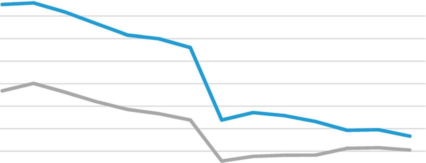
Land 2021, 10, 333                                                                                           3 of 18

                     frequently criticized due to its central enforcement, finality and unilateral foundation on
                     the simplified criteria of economic advantage. Intangible aspects, such as the nostalgic
                     relationship of citizens to their community, the preservation of cultural and mental values
                     were not taken into account.
                           This objective process continues in the market economy, even though it does not
                     receive more support from the center. The smallest settlements are threatened with de-
                     population, even the most basic services disappear from them and there are usually no
                     human or financial resources for any development. It is this category of settlements that
                     may be the subject of further consideration regarding the extinction of settlements as sites
                     of concentration of permanent housing for the population. There are naturally also villages
                     whose predisposition to extinction has not been confirmed. This is caused, among other
                     things, by changes in the trends of urbanization processes.
                           Present settlement theories react to post-productive transition and globalization. In
                     Europe, global approaches related to a unified continent are utilized in addition to emphasis
                     on regional identities [8]. The settlement system of Visegrád countries was analyzed e.g.,
                     by Hajdú et al. [9]. Bole et al. [10] explain the transition of functions of individual parts
                     of the Slovenian settlement system: large and medium-sized towns are changing from
                     having an industrial function to becoming seats of high quality services and creative
                     industries, small towns are changing into modern industrial centers, rural settlements
                     in the vicinity of regional centers are affected by suburbanization and peripheral rural
                     settlements are shrinking. In some countries, depopulation of small villages is a current
                     theme [11]. It is especially important in countries with not just rural to urban migration,
                     but an overall decrease in population (emigration to developed countries), which manifests
                     as a substantial reduction of the rural population [12,13]. Rumyantsev et al. [14] mention
                     rural settlements without any population.
                           The majority of settlement theories analyze the upper level of the system (metropolises,
                     regional and sub-regional centers, cities and towns). Rural settlements receive only marginal
                     attention as a rule. However, there are some urbanization processes, which also concern the
                     countryside. One of these is suburbanization, which transforms central areas into an urban-
                     rural continuum [15], where individual settlements and their original character almost cease
                     to exist. We can mention disappearing villages, not in the physical sense but in the sense of
                     the loss of their rural character and also identity.
                           Physical disappearance mostly concerns some very small villages in peripheral regions.
                     Increasing mobility allows the local population to meet requirements for job opportunities
                     and services in increasingly distant centers. At the same time, the sharp drop in employees
                     in the primary sectors of the national economy frees people from rural areas. The functions
                     of housing and newly developing tourism usually remain, but they do not seem to develop
                     in each of the existing villages. This is the basis for the gradual disappearance of the
                     permanent settlement function in some settlements.
                           Unless this concerns targeted liquidation of a village that needs to give way to an
                     investment intention, the termination of a settlement is usually gradual. In literature,
                     this process is sometimes called shrinkage [16]. Its features are usually closure of the last
                     services (post office, school, shop, restaurant, library), a fall in the number of permanent
                     residents and usually conversion of part of the housing fund into second homes or hos-
                     pitality facilities [17], sometimes adding an environmental format [18]. At present and in
                     the near future, the opposite process is not ruled out—i.e., the retroactive conversion of
                     cottages into permanently inhabited apartments. On the other hand, suggestions by some
                     experts for settlement of abandoned villages by immigrants from abroad with a different
                     culture [19] cannot be recommended. This would result in formation of a ghetto of people,
                     whose assimilation would be almost impossible in real time.
                           The problem of abandoned villages is current in some South and East European
                     countries. This is mainly the result of depopulation due to post-industrial changes in
                     the countryside. Felipe and Mascarenhas [20] document such a situation in Portugal,
                     pointing out that significant cultural heritage is disappearing along with the villages.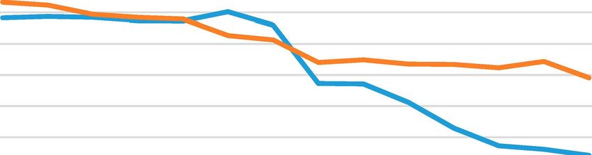
Land 2021, 10, 333                                                                                            4 of 18

                     Di Figlia [21] hopes that although the abandoned villages ceased to exist, their memory
                     could be preserved. Rural landscape changes due to abandoned settlements are generally
                     emphasized [22].
                           Under Czech conditions, post-war abandonment is connected mostly to expulsion of
                     the German population [23]. A similar experience can also be found in Poland [24,25] and
                     Slovenia [26]. In the former Soviet Union, the extinction of villages in the last century has
                     been associated with violent collectivization [27]. In Israel, villages abandoned by Arab
                     citizens after the Arab–Israeli wars (1947) were demolished in the 1960s [28]. Bański and
                     Wesełowska [29] discussed the broader spatial and socio-economic contexts. European
                     literature mainly discusses villages that disappeared during the Middle Ages [30,31], often
                     perceived as an archaeological subject. In the Mediterranean, in the Balkans, and some other
                     parts of Europe, this is still a current problem in relation to abandonment of the countryside
                     and land [32]. Re-use of abandoned buildings is widely discussed [33], particularly in
                     relation to an eventual tourism function [34], for the purpose of social agriculture [35] or
                     for the creation of ecovillages [36].
                           The expulsion of the German population from the Czech borderland and big cities is
                     one of the consequences of WWII. Specific numbers vary. It is estimated that approximately
                     2.2 million Germans were moved to the US and Soviet occupation zones in Germany.
                     Additionally, about 300,000–500,000 Germans from Czechoslovakia were killed on the
                     front lines during the war, about 300,000 escaped on Hitler’s command, about 200,000
                     remained missing and between 19,000 and 30,000 died or were killed during uncontrolled
                     expulsion before the official displacement was organized. The number of losses is higher
                     than the number of Germans before the war, because hundreds of thousands fled to the
                     Czech Republic before the end of the war. In any case, the Czech Republic lost more than
                     2 million Germans, the majority of them from the borderland.
                           Not all villages were re-settled after the expulsion. New settlers were directed towards
                     towns and larger villages in lower-altitude valley locations. Many small settlements in
                     the highlands and mountains were not re-settled or their re-settlement was not successful.
                     The population moved from mountains to the valleys, which had subsequent disastrous
                     consequences due to exposure to flood hazards [37]. Additionally, in relation to the
                     establishment of the iron curtain, some settlements in close vicinity to the borders were
                     destroyed with the goal of creating an empty buffer zone.
                           Some settlements had to give way to various technical works and other purposes.
                     The liquidation of settlements due to military training areas commenced during the Nazi
                     occupation and continued even after the war ended. Evacuated villages in military areas
                     were often used as training targets for the artillery. Later on, villages were destroyed due
                     to construction of (coal) mines, water reservoirs and nuclear power plants. In such cases,
                     the destruction was organized and residents were usually moved to new flats and houses
                     in other settlements in a planning way.
                           The aim of the article is to clarify the causes of the extinction of villages, its impact
                     on the landscape and on the settlement system, as well as the possibilities of preserving
                     the historical and cultural memory of extinct places. Finally, the danger of extinction of
                     villages at the present time is discussed.

                     2. Materials and Methods
                          Abandoned villages can be studied within the terms of various disciplines. Archaeol-
                     ogy examines features of physical substance and culture [38], anthropology is interested
                     in the human aspect of things and the immediate context of extinction [39], geography
                     examines the spatial distribution of extinct villages and the broader context.
                          A spectrum of geographical, sociological and ethnographic methods was used for
                     analysis of abandoned villages in Moravia. This consisted of a combination of analysis
                     of statistical data, secondary and cartographic sources, field research and remote sensing
                     methods (including old aerial photographs).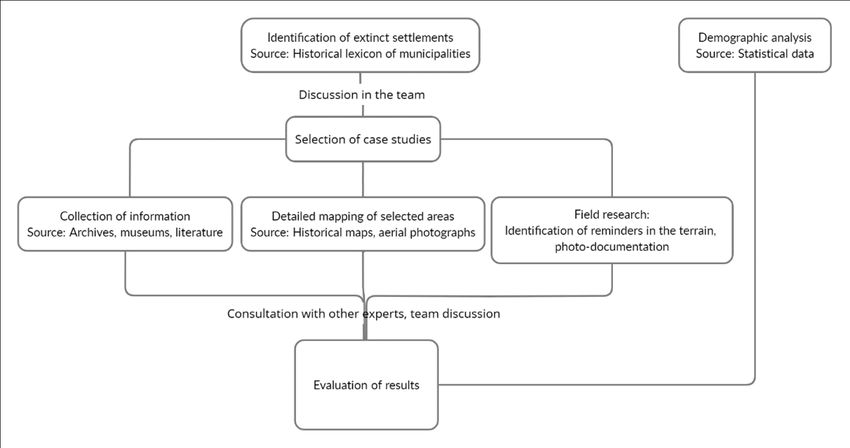
methods (including old aerial photographs).
The first step was to identify municipalities and parts of municipalities that disap-
peared from statistics during the second half of the 20th century. It was then determined
to what extent the statistically extinct settlements also physically disappeared. A field
Land 2021, 10, 333 5 of 18
search followed, which included the exact location of the defunct village and identified
any remains or references directly in the field. The results of historical mapping and aerial
photographs were used. The results were photographically documented. This more de-
The first step was to identify municipalities and parts of municipalities that disap-
tailed research tookpeared
placefromin Moravia and in the Czech part of Silesia in 2020. Further
statistics during the second half of the 20th century. It was then determined
information was sought to what onextent
the identified extinct
the statistically settlements.
extinct settlementsArchival and museum
also physically disappeared. ma-A field
terials, secondary sources and consulting
search followed, with the
which included local experts
exact locationwere
of theused.
defunct village and identified any
remainsinorthe
The main weakness references directly in thearea
methodological field. is
The results
the lackofofhistorical mapping
data from theand aerial pho-
period
tographs were used. The results were photographically documented. This more detailed
before, during and just after the war. Some archives were destroyed, others moved to an
research took place in Moravia and in the Czech part of Silesia in 2020. Further informa-
unknown location. A lotwas
tion of information
sought on thecan be found
identified in Soviet
extinct archives,
settlements. which
Archival and are difficult
museum materials,
to access. For villages that disappeared
secondary later, thewith
sources and consulting information
local experts situation
were used. is better.
The research area was The main
defined weakness
by the in historical
the methodological
territoryarea of is the lack and
Moravia of data from the
Silesia andperiod
the observed timeline was determined from 1945 to the present. The study unit for the to an
before, during and just after the war. Some archives were destroyed, others moved
unknown location. A lot of information can be found in Soviet archives, which are difficult
extinct settlements research
to access. was determined
For villages as municipality,
that disappeared part of municipality
later, the information or ham-
situation is better.
let with at least 5 residential buildings
The research registered
area was defined byastheofhistorical
1930. The termofvillage,
territory Moravia settlement
and Silesia and the
or hamlet refers to aobserved
spatially separated
timeline physical from
was determined structure
1945 toin thethe landscape,
present. The study consisting
unit for theofextinct
residential buildingssettlements
eventually research was determined
also other buildings. as municipality, part of municipality
The term municipality or hamlet with
or commune
at least 5 residential buildings registered as of 1930. The term village, settlement or hamlet
refers to the smallest unit of state administration and self-government. The municipality
refers to a spatially separated physical structure in the landscape, consisting of residential
may consist of several villages.
buildings Small municipalities
eventually also other buildings.are municipalities
The term municipality under or500 inhabit-
commune refers to
ants, very small municipalities
the smallest unit have of less
statethan 200 inhabitants.
administration The identified
and self-government. Thesettlements
municipality may
were localized on the consist
basisofofseveral villages. Small
comparative analysismunicipalities
of historicare municipalities
statistical under 500about
information inhabitants,
very small municipalities have less than 200 inhabitants. The identified settlements were
the numbers of residents and buildings according to Statistical lexicon of municipalities
localized on the basis of comparative analysis of historic statistical information about the
in the Czechoslovaknumbers
Republic, on theand
of residents basis of a census
buildings according dating from lexicon
to Statistical 1 January 1930 with in the
of municipalities
current public statistical data. Republic, on the basis of a census dating from 1 January 1930 with current
Czechoslovak
From this group of the
public settlement,
statistical data. the physically extinct settlements were chosen (i.e.,
settlements with the loss of settlementoffunction
From this group the settlement,
in thethe physically
period afterextinct
1945 in settlements
relation were
to de- chosen
(i.e., settlements with the loss of settlement function in the period after 1945 in relation
stroyed most of the to original buildings). The physical extinction of a settlement was veri-
destroyed most of the original buildings). The physical extinction of a settlement
fied by analysis of historic
was verifiedmap bymaterials, aerial survey
analysis of historic images
map materials, (from
aerial 1936)
survey and(from
images present
1936) and
orthophotomaps. Field presentresearch was subsequently
orthophotomaps. Field research carried out. Concentrations
was subsequently of endan- of
carried out. Concentrations
gered municipalitiesendangered
were evaluated municipalities were evaluatedThe
cartographically. cartographically.
procedure is Theinprocedure
Figure 1.is in Figure 1.
Figure 1. Research procedure.
Land 2021, 10, 333                                                                                            6 of 18

                     3. Results
                     3.1. Identification and Evidence of Extinct Settlements
                          Most of the extinct settlements are located in the borderland (along the inner border
                     of the Czech Republic). This phenomenon is mainly associated with the expulsion of the
                     original German population after World War II. However, the area is also affected for other
                     combined reasons associated with post-war geopolitical development—particularly the
                     declaration of a forbidden border zone established along the western border of the territory
                     and the establishment of military training areas. The area with extinct villages copies the
                     entire then border with Germany (which is today part border with Poland) and a large
                     number of extinct settlements are also located near the border with Austria (particularly
                     at the border with the South Bohemian Region). With a few exceptions, we can find only
                     a few extinct settlements in the interior. The reason for extinction in this case is usually
                     construction of infrastructure.
                          In general, there is a spatial disproportion in the distribution of extinct settlements
                     within Bohemia on one hand and Moravia and Silesia on the other hand. Exact numbers
                     are not available for comparison due to the inconsistent methodology of identification and
                     location of extinct settlements. However, the estimate of the number of extinct settlements
                     in Bohemia is ten times higher than the number in Moravia and Silesia. The amount of
                     extinction of settlements due to mining is also significant in North Bohemia.

                     3.2. Abandoned Villages in Moravia and Silesia as a Case Study Region
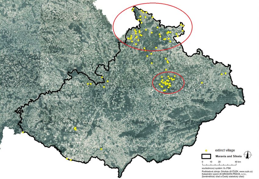
                           About one hundred extinct settlements can be identified within Moravian and Silesian
                     territory—these settlements can be classified as physically abandoned (in terms of current
                     physical structure) during the period after 1945. The most greatly affected areas are in
                     Sudetenland (the mountain range between the Moravian Gate and the passage of the
                     Elbe near Hřensko) associated with the expulsion of the original German population. The
                     districts of Jeseník, Bruntál and Šumperk were most heavily affected—a total of two thirds
                     of all extinct settlements in Moravia and Silesia are located there (border area in Figure 2).
                     Another numerically significant group consists of a cluster of municipalities that disap-
                     peared as a result of establishment of the Libavá military district (a total of 26 settlements,
                     the area in Figure 2 in the interior). An interesting fact is that only three settlements within
                     the entire area of Moravia and Silesia disappeared due to the establishment of a forbidden
                     border zone. Other reasons are attributed to just a few defunct settlements—due to the
                     construction of the Dukovany Nuclear Power Plant, water reservoirs, deep black coal
                     mining or the construction of an airport.
                           The map shows the significant territorial disproportion in relation to abandoned
                     settlements on the north-south axis. Most of the extinct villages are located in the northern
                     part of Moravia and Silesia. The environmental conditions (particularly the significantly
                     colder climate, the higher altitude, the ruggedness of the terrain and the poor fertility of the
                     soil) can be pointed out as a significant implicational reason for settlements disappearing
                     in this area in the broader scope. These factors complicated re-population of areas during
                     the subsequent period, while settlements in the South Moravian borderland were usually
                     re-settled due to prosperous agriculture and viticulture.

                     3.3. Analysis of the Course, Reasons and Results of the Villages Abandonment
                          In the case of settlements that were not re-settled after expulsion of the German
                     population, unused buildings were usually dismantled and used as building materials
                     elsewhere. The rest were deliberately destroyed in the 1950s, as dilapidated buildings
                     posed a security risk and worsened the image of border regions. Some isolated buildings
                     remained and were usually secondarily used as warehouses, dormitories for seasonal
                     workers, farm buildings or second homes. In this area of the borderland, we can find
                     numerous ruins and other remains of the original settlements. Sometimes a religious
                     artefact survived, such as a torment, ruins of chapels or churches, or a cemetery. These
                     sacral artefacts had been in a desolate condition after the 1950s. Sometimes, it was voluntary
Land 2021, 10, 333 7 of 18
associations who restored these buildings and preserved their history for the public. Local
Land 2021, 10, x FOR PEER REVIEWmemory is currently being restored in some places, for example, as part of the creation
7 ofof
18
educational trails or simply as a result of restoration of sacral elements.
Figure2.2. The
Figure The location
location of
of extinct
extinctsettlements
settlementswithin
withinthe
theterritory ofof
territory Moravia and
Moravia Silesia.
and Source:
Silesia. Source:
Orthophoto © ČÚZK, © ARCDATA PRAHA; editing by Peřinková, V., Mašíček, T.
Orthophoto © ČÚZK, © ARCDATA PRAHA; editing by Peřinková, V., Mašíček, T.
Thelocalities
The map shows the significant
of abandoned territorial
villages disproportion
manifest differentlyin inrelation
the field.toFrom
abandoned set-
the point
tlements
of view ofon thethe north-south
relation to the axis. Most of
landscape, thethe extinct question
essential villages are located
is what in the
arose northern
in the terri-
part of Moravia and Silesia. The environmental conditions (particularly
tory of extinct villages. For this purpose, the representation of individual habitats was the significantly
colder climate,
analyzed [40]. Fortheeach
higher altitude,
defunct the ruggedness
settlement, individualof the terrain
types and the
of natural poor
and fertility of
non-natural
the soil) can be pointed out as a significant implicational reason for settlements
habitats were searched for, which are currently located on the territory of the former built- disappear-
ingarea
up in this
of thearea in thesettlement
defunct broader scope.
and itsThese
adjacentfactors complicated
landscape, or in the re-population
entire cadastral of areas
area
during
of the subsequent
the defunct settlement. period, while settlements in the South Moravian borderland were
usually
The re-settled due toinprosperous
natural habitats the areas ofagriculture and viticulture.
extinct settlements are dominated by mesophilic oat-
grass meadows (located in the territory of 70% of all extinct settlements), riverine ash-alder
3.3. Analysis
woodland, of the
florid Course,
beech Reasons
forests and andhighResults of theand
mesophilic Villages Abandonment
xerophilic shrubs. Among the non-
naturalInhabitats
the case(Figure 3) in many
of settlements thatareas
wereofnotextinct settlements,
re-settled there are ruderal
after expulsion herbaceous
of the German pop-
vegetation typicalbuildings
ulation, unused of desolate habitats
were usuallyof ruins, as well
dismantled as conservation-significant
and used as building materials stands
else-
with
where.theThe
potential
rest were to develop and destroyed
deliberately transformin into
thenatural
1950s, as habitats,
dilapidatedforestbuildings
cultures posed
with
non-native
a security conifers
risk andinworsened
the territorytheofimage
80% ofofallborder
extinctregions.
settlements,
Someasisolated
well as conservation-
buildings re-
significant
mained and were usually secondarily used as warehouses, dormitories forvegetation
stands, which have the potential to develop natural forest seasonal work-and
which are typical of overgrown borders and heaps with deposits
ers, farm buildings or second homes. In this area of the borderland, we can find numerousof stones from fields
and
ruinsdemolished
and other foundations.
remains of the Of original
the habitats, units forSometimes
settlements. the conversion of natural
a religious habitats
artefact sur-
to Natura
vived, such2000
as ahabitat
torment, types,
ruinsTilio-Acerion
of chapels or forests
churches,on or
slopes, rubbleThese
a cemetery. and ravines, mixed
sacral artefacts
ash-alder
had been floodplain
in a desolate forests of temperate
condition after the and boreal
1950s. Europeitand
Sometimes, wasnon-priority extensive
voluntary associations
mowed lowland meadows are the most represented in extinct settlements.
who restored these buildings and preserved their history for the public. Local memory is
currently being restored in some places, for example, as part of the creation of educational
trails or simply as a result of restoration of sacral elements.
The localities of abandoned villages manifest differently in the field. From the point
of view of the relation to the landscape, the essential question is what arose in the territory
of extinct villages. For this purpose, the representation of individual habitats was ana-
lyzed [40]. For each defunct settlement, individual types of natural and non-natural habi-
tats were searched for, which are currently located on the territory of the former built-up
area of the defunct settlement and its adjacent landscape, or in the entire cadastral area of
the defunct settlement.fields and demolished foundations. Of the habitats, units for the conversion of natural
habitats to Natura 2000 habitat types, Tilio-Acerion forests on slopes, rubble and ravines,
mixed ash-alder floodplain forests of temperate and boreal Europe and non-priority ex-
tensive
Land 2021, 10, 333mowed lowland meadows are the most represented in extinct settlements. 8 of 18
Figure 3. Numbers of extinct municipalities with representation of individual types of non-natural habitats. Source: own
elaboration with use of the web portal of the information system of nature protection http://webgis.nature.cz/mapomat/
Figure 3. Numbers of extinct municipalities with representation of individual types of non-natural
(accessed 22 January 2021).
habitats. Source: own elaboration with use of the web portal of the information system of nature
protection http://webgis.nature.cz/mapomat/, accessedof22village
The causes and manifestations January 2021 are clearly shown in Table 1.
extinction
Table 1. Causes of the extinction of villages in Czechia after World War II.
The causes and manifestations of village extinction are clearly shown in Table 1.
Cause Manifestation
Table 1. Causes of the extinction of villages in Gradual
Czechia after World
reduction War II.
of population and abandonment of houses; from
Depopulation in general in most remote positions
the 1960s conversion into second homes
Cause Manifestation
Insufficient or unsuccessful settlement, dilapidation of buildings,
Depopulation in relation to expulsion of Germans
Depopulation in general in sometimes
Gradual reduction of population physical liquidation around 1960
and abandonment of
Targeted physical liquidation of settlements at the Iron Curtain in
most remote
Political-defensive positions
reasons in the borderlandhouses; from the 1960s conversion into second homes
order to free up space for border control
Depopulation in relation to Insufficient or unsuccessful
Eviction of the majority of thesettlement,
population fromdilapidation
military trainingofareas;
Military areas
expulsion of Germans buildings, sometimes physical
villages were sometimesliquidation around
used as training targets 1960
Political-defensive reasons in TargetedPlanned physical liquidation of settlements,
liquidation which had to give
of settlements at thewayIron
to large
Big construction, mining constructions or mining; the population was relocated in an
the borderland Curtain in order to free up spacemanner
organized for border control
Eviction of the majority of the population from military
Military areas Examplestraining of contemporary reminders
areas; villages wereof extinct
sometimes settlements
used can be found in
as training
Figures 4 and 5.
targets
As part of political liberalization in the 1990s, some military areas were terminated or
reduced, especially after the departure of the Soviet Army from Czechoslovakia. This also
enabled the theoretical restoration of permanent settlement. However, this effect on the
settlement system has similar problems to the effect on villages in peripheral areas [41].Planned liquidation of settlements, which had to give
Big construction, mining way to large constructions or mining; the population
was relocated in an organized manner
Land 2021, 10, 333 9 of 18
Examples of contemporary reminders of extinct settlements can be found in Figures
4 and 5.
(a) (b)
(c) (d)
Figure
Figure 4.
4. Case
Casestudy
studyofofHřibová
Hřibová(Pilzberg
(PilzbergininGerman,
German,a asettlement
settlementofof
Vlčice municipality):
Vlčice aerial
municipality): aerial
survey
survey images
images from (a) 1937,
from (a) 1937, (b)
(b) 1964
1964 and
and (c)
(c) 2019
2019Source:
Source:https://ags.cuzk.cz/archiv/
https://ags.cuzk.cz/archiv/ accessed
(accessedonon
21 March 2004, (d) photograph of the current landscape (the authors).
21 March 2004), (d) photograph of the current landscape (the authors).
3.4. Demographic Analysis and Urbanization Process
The depopulation of villages on the border is taking place against the background of
ongoing urbanization processes. In the second half of the 20th century, it was a one-way
rural-to-urban migration. This process was supported by the so-called centralized settle-
ment system, where state-controlled or supported housing construction was concentrated
in cities and other centers, while in the case of so-called municipalities without permanent
significance, there was a building closure.
The result of this process was not only the depopulation of border areas (except for
heavily industrialized), but also the concentration of inhabitants in cities and other selected
centers. This process undoubtedly
(a) contributed to the extinction of (b)
small villages in remote
locations. Some examples of such a development can by found on figure Z where four
borderland areas were choosen.
Javorník area (Figure 6a) is situated in the Czech part of Silesia near the present border
with Poland. It is separated from the Czech hinterland by the ridges of the Rychlebské
Mountains. It consists of 13 municipalities. In addition to small municipalities, there are
three small towns in the area. A total of 23 settlements disappeared here after World War II.
Similarly, the Osoblaha area (Figure 6b) is located in the Czech part of Silesia. The
microregion has a reputation as one of the most remote areas in the Czech Republic. The
peculiarity of this micro-region,
(c) consisting of 7 municipalities, is the
(d)absence of any urban
center. However, even here, the proportion of the population living in the central settlement
has increased. A total of 6 villages disappeared here after World War II.(c) (d)
Land 2021, 10, 333 Figure 4. Case study of Hřibová (Pilzberg in German, a settlement of Vlčice municipality): aerial
10 of 18
survey images from (a) 1937, (b) 1964 and (c) 2019 Source: https://ags.cuzk.cz/archiv/ accessed on
21 March 2004, (d) photograph of the current landscape (the authors).
(a) (b)
Land 2021, 10, x FOR PEER REVIEW 10 of 18
(c) (d)
(e) (f)
(g) (h)
Extinctsettlements–contemporary
Figure 5. Extinct settlements–contemporarystate. state. Source:
Source: the the authors.
authors. (a,b)(a,b) In some
In some localities,
localities, sa-
cral elements
sacral elementshavehavebeen partially
been preserved
partially andand
preserved are now the subject
are now of renovation:
the subject (a) Annín
of renovation: (a) Annín
(50.3480656N, 17.0993603E),
(50.3480656N, 17.0993603E), (b)(b) Prameny
Prameny (50.0498400N,
(50.0498400N,16.9803808E).
16.9803808E).(c,d)
(c,d)Many
Manylocalities
localitiesareareused
recreationally, either in connection with cultural heritage in relation to the extinction, or in the or
used recreationally, either in connection with cultural heritage in relation to the extinction, in
context
the context of drastic changes to land use in history: (c) Hraničky (50.3096286N, 16.9825203E), (d)
of drastic changes to land use in history: (c) Hraničky (50.3096286N, 16.9825203E), (d) Hřibová
Hřibová (50.3469511N, 17.0102036E). (e,f) Many localities are used recreationally, either in connec-
(50.3469511N, 17.0102036E). (e,f) Many localities are used recreationally, either in connection with
tion with cultural heritage in relation to the extinction, or in the context of drastic changes to land
cultural heritage
use in history: (e) in relation
Josefová to the extinction,
(50.1481867N, or in the(f)
17.0654403E), context
Mušovof(48.8959706N,
drastic changes to land use in
16.6000064E).
history: (e) Josefová (50.1481867N, 17.0654403E), (f) Mušov (48.8959706N, 16.6000064E).
(g,h) Traces of agricultural management are still visible in the highest locations (stone walls); (g,h) Traces
there
of agricultural management are still visible in the highest locations (stone walls);
is now a forest or pasture on the site: (g) Zastávka (50.3492172N, 17.0102894E), (h) Kamenné there is now a
forest or pasture
(50.2845539N, on the site: (g) Zastávka (50.3492172N, 17.0102894E), (h) Kamenné (50.2845539N,
17.0459211E).
17.0459211E).
As part of political liberalization in the 1990s, some military areas were terminated
or reduced, especially after the departure of the Soviet Army from Czechoslovakia. This
also enabled the theoretical restoration of permanent settlement. However, this effect on
the settlement system has similar problems to the effect on villages in peripheral areas
[41].Land 2021, 10, 333 11 of 18
Hanušovice (Figure 6c) is located in northern Moravia. Unlike other selected cases,
Hanušovice was an industrial center (textile and food production), in neighboring Jindři-
chov, there was a paper mill. The micro-region consists of 8 municipalities, two of which
are small towns. After World War II, 17 settlements disappeared in the Hanušovice area.
Here, the concentration of inhabitants in the center is most striking—probably due to the
complex relief, which increases the remoteness of settlements outside the main valley.
The Slavonice area (Figure 6d) represents the example of southern Moravia, where the
extinction of villages is not so common. It is a small area, consisting of 4 villages, where,
however, after the Second World War, 5 villages disappeared. It is quite obvious that the
depopulation of the small town of Slavonice is gradual, as rural villages have experienced
a relatively steep decline.
Javornfk area
30,000
25,000
� 20,000
C
re
+-'
15,000
re
..c
10,000
5000
0
186 9 18 80 18 90 1900 1910 19211930 1950 19611970 19 80 19 912001 2011
Year
-other villages -Javornfk
(a)
Osoblaha area
8000
7000
6000
C 5000
+-'
re
.-t= 4000
re
..c 3000
C
2000
1000
0
186 9 18 80 18 90 1900 1910 19211930 1950 19611970 19 80 19 9120012011
year
-other villages -osoblaha
(b)
Figure 6. Cont.Land 2021, 10, 333 12 of 18
Hanusovice area
18,000
16,000
14,000
V,
+-'
12,000
C
"
ro
+-' 10,000
:0
ro 8000
..c
-
C
6000
4000
2000
0
1869 1880 1890 1900 1910 1921 1930 1950 1961 1970 1980 1991 2001 2011
year
-other villages -Hanusovice
(c)
Slavonice area
4000
3500
3000
V,
+-'
C 2500
ro
+-'
:0 2000
ro
..c 1500
C
1000
500
0
1869 1880 1890 1900 1910 1921 1930 1950 1961 1970 1980 1991 2001 2011
year
-other villages -slavonice
(d)
Figure 6. (a) Population development in the Javorník area 1869–2011, (b) population development
in the Osoblaha area 1869–2011, (c) population development in the Hanušovice area 1869–2011 and
(d) population development in the Slavonice area 1869–2011; Data source: Historický lexikon obcí
1869–2011. Own elaboration
In all cases, it turns out that the sharp decline in the population of non-central municipali-
ties occurred between the censuses of 1930 and 1950, i.e., in connection with World War II. This
would point to an obvious connection with the expulsion of the German population. However,
if we looked at the population development of municipalities on the opposite side of the
border in Austria, Bavaria or Saxony, we would also find significant depopulation tendencies.
For example, the population of Waldkirchen an der Thaya, opposite Slavonice, fell from 1379
to 522 between 1939 and 2019, with 6 out of 7 villages having less than 100 inhabitants. The
difference is that in neighboring countries, this process has taken place gradually. It turns out
that the expulsion of the Germans was not so much the cause of the extinction of the villages,
but rather the catalyst for a process that tooks place naturally.ulation. However, if we looked at the population development of municipalities on the
opposite side of the border in Austria, Bavaria or Saxony, we would also find significant
depopulation tendencies. For example, the population of Waldkirchen an der Thaya, op-
posite Slavonice, fell from 1379 to 522 between 1939 and 2019, with 6 out of 7 villages
Land 2021, 10, 333 having less than 100 inhabitants. The difference is that in neighboring countries, this 13 ofpro-
18
cess has taken place gradually. It turns out that the expulsion of the Germans was not so
much the cause of the extinction of the villages, but rather the catalyst for a process that
tooks place naturally.
ItItisisclear
clearfrom
fromFigure
Figure7 that there
7 that are are
there mainly veryvery
mainly small settlements
small among
settlements the villages
among the vil-
that
lages that disappeared on the border. The population of most of them fell belowbefore
disappeared on the border. The population of most of them fell below 100 the
100 before
war. As for the villages, which disappeared in a planned way, because
the war. As for the villages, which disappeared in a planned way, because they had to they had to give
way
givetoway military premises
to military or large
premises or investments, there are
large investments, rather
there small villages
are rather slightly
small villages over
slightly
200 inhabitants.
over 200 inhabitants.
19.5
26.8
9.8
12.2
31.7
less than 50 51-100 101-150 151-200 201+
Figure7.7.Portions
Figure Portionsofofsize
sizecategories
categoriesofofvillages
villagesthat
thatdisappeared
disappearedininthe
theMravian
Mravianand
andSilesian
Silesian bor-
border-
derland with Poland and Austria [%].
land with Poland and Austria [%].
3.5.Depopulated
3.5. DepopulatedSmall
SmallVillages
VillagesininCzechia
CzechiaatatPresent?
Present?
TheCzech
The Czech Republic has has the
themost
mostfragmented
fragmentedadministrative
administrative structure in Europe.
structure To-
in Europe.
gether 1444
Together 1444municipalities
municipalitiesoutoutof of the
the total
total of 6253 have
have fewer
fewerthan
than200
200inhabitants
inhabitants[42].
[42].InIn
Moravia,there
Moravia, thereis is a difference
a difference between
between largelarge villages
villages in theinlowlands—often
the lowlands—often exceeding
exceeding 2000
or more
2000 or inhabitants, and small
more inhabitants, and villages in the mountains
small villages bordering
in the mountains the main
bordering thetransit route
main transit
through the Moravian
route through Gate (Hrubý
the Moravian GateJeseník
(Hrubý Mountains and Bohemian-Moravian
Jeseník Mountains Highlands
and Bohemian-Moravian
inHighlands
the west in and West Carpathians in the east). The entire settlement
the west and West Carpathians in the east). The entire settlement system depends
system
on a denseon
depends structure
a dense of small towns
structure of small fulfilling
townsthe role ofthe
fulfilling centers ensuring
role of centers jobs, services,
ensuring jobs,
social contacts, transport links and micro-regional identity. Everyday life takes place in the
functional systems created by small towns and rural settlements in the outlying regions [43].
The distribution of municipalities with less than 200 inhabitants, some of which are
endangered by depopulation, can be seen in Figure 8. It is clear that these municipalities
are concentrated on regional borders (between NUTS 3 regions) and in some parts of the
borderland area. The risk of village extinction is associated with a wider process of rural
depopulation, which was typical especially for a productive society. The current transition
to a post-productive society modifies this process. Nowadays, housing in remote villages
is becoming attractive again, so that even the size category of municipalities with less than
200 inhabitants is experiencing a migration increase as a whole. If these municipalities lose
population, it is the result of natural decline, which is associated with aging. The number
of municipalities with less than 200 inhabitants has a decreasing tendency. There were
1736 such municipalities in the Czech Republic in 2000, while in 2015 there were only 1444.
At the same time, the total number of municipalities remains more or less the same. This
means that the reason for the fall in the number of very small municipalities is that their
population has exceeded the limit of 200 inhabitants and more.200 inhabitants is experiencing a migration increase as a whole. If these municipalities lose
population, it is the result of natural decline, which is associated with aging. The number
of municipalities with less than 200 inhabitants has a decreasing tendency. There were
1736 such municipalities in the Czech Republic in 2000, while in 2015 there were only 1444.
At the same time, the total number of municipalities remains more or less the same. This
Land 2021, 10, 333 14 of 18
means that the reason for the fall in the number of very small municipalities is that their
population has exceeded the limit of 200 inhabitants and more.
Figure 8.8.
Figure Localization ofof
Localization very small
very municipalities
small inin
municipalities the
theCzech
CzechRepublic.
Republic.Source:
Source:[42].
[42].
Migrationtrends
Migration trendsandanddirections
directions have
have been changing
changing since
sincethe
themid-1990s.
mid-1990s.Earlier
Earliermigra-
mi-
tion from
gration fromrural to urban
rural to urbanareas, supported
areas, by the
supported bymass construction
the mass of prefabricated
construction housing
of prefabricated
estates estates
housing in cities
inand
citiesthe
andadministrative capping
the administrative of construction
capping in so-called
of construction settlements
in so-called settle-
without
ments permanent
without significance,
permanent was replaced
significance, by bilateral
was replaced migration,
by bilateral in which
migration, migration
in which mi-
from cities to rural areas slightly predominates. The targets of this migration
gration from cities to rural areas slightly predominates. The targets of this migration are are naturally
mainly suburbanized
naturally villages, but
mainly suburbanized peoplebut
villages, arepeople
also moving to moving
are also more distant and distant
to more smaller and
rural
settlements to a lesser extent. On one hand, the main drives are cheaper
smaller rural settlements to a lesser extent. On one hand, the main drives are cheaper housing in the
more remote
housing countryside—especially
in the more for the elderly,
remote countryside—especially forand on the other
the elderly, hand,
and on a better
the other and
hand,
a quieter natural
better and environment
quieter for young families.
natural environment for young families.
4. Discussion
4. Discussion
The risk of village extinction is associated with a wider process of rural depopulation,
The risk of village extinction is associated with a wider process of rural depopulation,
which was typical especially for a productive society. The current transition to a post-
which was typical especially for a productive society. The current transition to a post-
productive society modifies this process. Nowadays, housing in remote villages is becoming
attractive again, so that even the size category of municipalities with less than 200 inhabi-
tants is experiencing a positive migration balance as a whole. If these municipalities lose
population, it is the result of natural decline, which is associated with aging.
However, it is also necessary to realize that the process of transformation to a post-
productive society has a reverse side. There is increased interest in the use of rural set-
tlements for housing and tourism, especially for second homes. While housing tends to
be located in rural settlements with basic social infrastructure and with adequate access
to larger centers, second homes and tourism can also be found in locations in the remote
countryside. Therefore, rather than the extinction of rural municipalities, it is currently
possible to assume their transformation from agricultural settlements to residential or recre-
ational settlements. After all, even uninhabited villages after displacement of the German
population—if their buildings were not razed to the ground—have been transformed into
second-home villages since the 1960s.
One must realize that the basic structure of Central European settlement originated in
the 13th century. Since then, individual settlements have been disappearing. The original
villages were located so that the farmer would be able to walk to the fields, work and
return home within a reasonable time. This means that the villages had to be relatively
densely situated. Today’s rural resident, who is motorized and mostly works in the villageLand 2021, 10, 333 15 of 18
or town, does not need such a dense network of villages. So, if we are talking about the
danger of extinction of villages, we are primarily concerned with their cultural heritage,
not their technical and economic substance.
This historical heritage can be preserved without having to preserve the physical struc-
ture of villages—especially in a situation where the historical heritage of the countryside
disappears under the pressure of suburbanization, counter-urbanization, the introduction
of non-original buildings and the urban way of life. The preservation of the genius loci, the
landscape memory and the spiritual heritage does not necessarily have to be linked to the
preservation of the physical structure of the village [44]. It can be associated with a certain
place in a field—a chapel, a cross, the rest of the settlement, a monument—to which the
spiritual heritage may be related.
Larger settlements are more efficient for housing in today’s world and can have
a complete range of basic social services and full technical equipment. The smallest
settlements are suitable for recreation activities, or for those residents who prefer quiet
solitude close to nature. However, these people should be either mobile or reconciled to
the fact that they will live in settlements with a very limited infrastructure.
5. Conclusions
The process of extinction of rural settlements has lasted throughout the existence of
settlements and is likely to continue. However, conditions and contexts are changing. There
are currently two reasons for the demise of settlements. The first reason is the need for
space for significant investment plans by some populated places. This currently especially
concerns the construction of reservoirs and also the expansion of coal mining. While during
the period of a centrally planned economy such a decision was in the hands of the state,
today it is the subject of a struggle between the involved groups [45].
The second reason may consist of gradual extinction for demographic reasons. It in-
cludes a combination of aging and emigration trends in the smallest settlements. Our
research confirms that such tendencies affect approximately half of rural settlements with
less than 100 inhabitants. However, there does not appear to be a risk of physical extinction
in these cases. Rather, it is likely that these settlements will change their function from
permanent villages to seasonal second home sites, including the formation of a new local
and regional identity [46]. At the same time, it is possible that in some cases, there may be
a partial regeneration of the function of permanent settlements later on, as people change
their residential preferences and discover the benefits of living in small and remote villages.
The demise of villages should not be considered a tragedy. The most precious part of
them is their intangible heritage: memories, documents, the spirit of the place. While until
the 1980s, the landscape was understood in the literature primarily as a natural element,
possibly influenced by man, since the 1990s, the landscape is evaluated more as a space
for human life. It goes without saying that a landscape understood in this way is not
ideologically neutral [47]. The landscape of extinct settlements could be perceived as a
mindscape [48]. However, this heritage can and should be preserved, for example, in the
form of a digital chronicle that can preserve intangible heritage. The relationships between
memory and place are essential for the identity and thus the motivation of people [49].
The process of depopulation and extinction of villages is an interesting historical-
geographical and urban planning problem, which may be of interest to experts in many
other disciplines, because there are links to changes in the landscape for example. The
historical period of the aftermath of World War II and real socialism ended in the 1990s.
At present, villages usually do not disappear physically, but change into places of second
residence. Quantitative and qualitative evaluation of this transformation can be one of
the directions of research. The second direction of research may be the restoration and
preservation of historical memory. The advantage is that current generations are no longer
so much influenced by nationalist prejudices. On the contrary, the disadvantage is that
witnesses are gradually dying out, and in some cases, it is already very difficult to getYou can also read


