Designing A Land Use Planning Solution for Land Degradation Neutrality The GEO-LDN Competition
←
→
Page content transcription
If your browser does not render page correctly, please read the page content below
Designing A Land Use Planning Solution for Land Degradation
                               Neutrality
                                  The GEO-LDN Competition
                                        Concept Note, 04/09/2020

        Earth observations (EOs) have never been in more demand than today. On the supply
        side, meeting this demand will require innovation and collaborative action, especially
        given the potential risk of budget revisions for EO-related data supply programmes due
        to the on-going impacts of COVID-19 on the global economy.

        The Group on Earth Observations Land Degradation Neutrality (GEO-LDN) Initiative is
        sponsoring an international technology innovation Competition to design and build
        software analytics solutions to support the development of an open source tool to assist
        land use planning in the context of Land Degradation Neutrality.

        The Competition will culminate in a prototype demonstration and award ceremony at
        the occasion of the nineteenth session of the UNCCD Committee of the Review of the
        Implementation of the Convention in the first quarter of 2021 in Bonn, Germany, where
        decision-makers will have the opportunity to provide real time feedback, vote their top
        prototype and further develop their capacity to use EO data in preparation for the
        UNCCD 2021-2022 national reporting process.

1. Background

Earth observations (EOs) have never been in more demand than today. The COVID-19 pandemic has fast-
tracked the need for EO data and services, especially Big Data Analytics, for crisis monitoring, for analyzing
the impact of the disease outbreak on the global economy, for planning responses and for scenario
development.
Building back better after this pandemic will require understanding and addressing another global crisis,
the crisis in unsustainable land use. As leading contributors to the loss of wild habitats and terrestrial
biodiversity, changes in land cover and land use are recognized as a primary transmission pathway for
emerging infectious diseases, and more optimal use of land will be central to building back better in the
wake of the pandemic. The sustainable management of land and its restoration provide a wide range of
benefits to society, reduce pressure on natural systems and contribute to climate change mitigation and
adaptation. Land Degradation Neutrality (LDN) – “a state whereby the amount and quality of land
resources necessary to support ecosystem functions and services and enhance food security remain stable
or increase within specified temporal and spatial scales and ecosystems” (decision 3/COP.12, UNCCD,

                                                                                                            1
2015a) - remains a key mechanism in the global response to the challenges posed by the COVID-19 crisis
and has the potential to act as an accelerator and integrator for achieving the Sustainable Development
Goals (SDGs). To date, over 120 countries have committed to setting LDN targets. More than 80 countries
– over two thirds – have already set their targets, and many have secured high-level government
commitment to achieve LDN.
The Group on Earth Observation Land Degradation Neutrality (GEO-LDN) Initiative - a unique stakeholder-
driven initiative with a clear policy mandate from the United Nations Convention to Combat
Desertification (UNCCD) - aims at helping national and local actors in all countries use EOs to achieve LDN,
as set out in the SDG target 15.3. It promotes and supports the collaborative development, provision and
use of EO datasets, quality standards, analytical tools and capacity building to avoid, reduce, and reverse
land degradation, thereby addressing some of the most common bottlenecks in the use of EOs.
2. The GEO-LDN Competition: Designing A Land Use Planning Solution for Land Degradation
Neutrality
Working Group 3 (WG3) of the GEO-LDN Initiative is working to support the development of an open and
collaborative data analytics platform – a system of systems – to support planning, implementation, and
monitoring of actions to achieve LDN from EO and other data sources. These tools and methods are being
developed using a modular approach, so that tools can evolve as technology and user needs change. The
WG can therefore leverage work already conducted under related initiatives (Trends.Earth, Open Foris,
openEO, EO4SDG, CEOS, etc.).
With a view to inspire innovation as well as collective and coordinated action towards its goals, the GEO-
LDN Initiative, in collaboration with the UNCCD Science-Policy Interface, is sponsoring a Competition to
support data analytics around land use planning in the context of LDN, with the aim of connecting the
technical and software development expertise of third party groups or organisations with end users at the
forefront of the on the ground action that is needed to achieve LDN.
3. Challenge
The GEO-LDN Competition is an international technology innovation competition to design and build
software analytics solutions to support more transparent and well-informed land use decisions at the local
to national level across the globe (“Competition”). Winning solutions will be promoted by the GEO-LDN
Initiative and the UNCCD for use by all countries committed to set voluntary LDN targets and to monitor
and report on SDG Indicator 15.3.1 “Proportion of land that is degraded over total land area”.
The challenge is to develop a software tool to implement, or support the implementation of a “neutrality
mechanism” for LDN within a well-established open source model that allows for trade-off analysis, and
which can then be adapted for use by any other such modelling tools. See the Competition rules for
specific information on how each entry will be evaluated.
A “neutrality mechanism” refers to a no net loss land use planning module that would allow users to
generate scenario maps of the anticipated future impact of all land uses for a given area in net terms. The
resulting “neutrality maps” would allow the visualization and quantification of gains (where interventions
are planned to reverse past land degradation), stable areas (where the land-based natural capital can be
2maintained through good management), and anticipated losses (where realistically it is determined that
land degradation may not be avoidable). No net loss would occur when the planner is able to generate a
scenario where all anticipated losses can be counterbalanced with planned gains for each land type, while
the integrity of all other land is maintained.
Because land degradation is driven by many competing social, economic and environmental demands for
land resources, the tool also needs to have the capacity to analyze trade-offs in ecosystem services.
Specific ecosystem services will have different values in different places to different stakeholders, and
human values may change over time. Where decisions involve trade-offs between ecosystem services, or
between environmental and social goals, transparent participatory processes should be applied to
prioritize between different ecosystem services, based on needs and goals of the stakeholders.
More details about the neutrality mechanism for LDN are available in Cowie et al. 2018, and in Module C
of the Scientific Conceptual Framework for Land Degradation Neutrality.
The overall aim is that the tool will not only be useful (i.e. data and information meet information needs)
and usable (i.e. the tool allows easy access) but that it will also be used. Therefore, it is important not to
design for the users but to design with the users from the very beginning, in line with the Principles for
Digital Development. Users must be actively involved in the co-design and development of the prototype,
which should serve a concrete use case on the ground. Competitors should demonstrate that their
solution works, in the context of this concrete use case and corresponding data sets. Further details on
these requirements are listed in the Competition rules.
By addressing this challenge, the Competition will contribute to fulfill decision 18/COP.14, in which
country Parties requested the UNCCD Science-Policy Interface to stimulate the development of “a
demonstration, resulting from an open call, of how LDN can be incorporated into existing open source
land use planning and trade-off analysis tools.”
4. Why participate?
All participants will benefit from:
• Valuable feedback on their ideas from potential end-users.
• Access to and support from internationally acknowledged technical experts in the field of Earth
Observation, big data analysis, land use planning and LDN.
• Support and facilitation in development of the prototype, including expert’s advice on human-
centered design.
• Access to a vibrant community of practice under the auspices of the GEO-LDN Initiative.
The top three competitors will benefit from:
• A license for free access to use Google Earth Engine (GEE) as part of their solution. The duration
of the license will be for a 2-year period.
• In-kind technical support and mentoring by EO Data Science through an outreach programme to
help their solutions obtain the results needed from GEE. EO Data Science is a dedicated Earth
Observations company and a leading GEE partner globally.
The winner(s) of the Competition will benefit from:
3• Opportunity to develop the tool for the benefit and use of over 120 countries committed to set
LDN targets.
• Financial and technical support valued at USD 100,000 for the transformation of the prototype
into an operational and scalable tool.
• Opportunity to further showcase the tool(s) at the fifteenth session of the UNCCD Conference of
the Parties and at the GEO Week 2021.
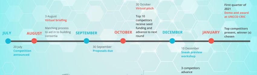
5. Timeline
The Competition will run from July through the nineteenth session of the UNCCD Committee for the
Review of Implementation of the Convention (CRIC 19) in the first quarter of 2021 in Bonn, Germany.
The Competition will conclude with a final Jury Panel decision and award ceremony at CRIC 19.
The full timeline is below:
• July 20, 20020: Competition announcement
• August 3, 2020: Virtual briefing session: Interested competitors will be invited to attend a
virtual briefing session where the Competition organizers will provide guidance about the
product(s) to be developed. The recording and slide deck of the virtual briefing session is
uploaded to the Competition’s website.
• August 3 to September 20, 2020: Matching process: The organizers will support a matching
process via the forum on the Competition website to aid individuals interested in applying that
have not already identified a consortium.
• August 3, 2020 to the end of Competition: Support in human-centered design. A human-
centered design expert will provide useful material via the competition webpage and offer
direct advice to teams who seek support in how to design with the user.
• August 3, 2020 to the end of Competition: FAQ. The organizers of the Competition will ensure
that any advice given to any of the competitors will be published on the FAQ section of the
Competition website immediately. This includes advise given by the human-centered design
expert to individuals teams. This way full transparency of the given advice is ensured.
• September 30, 2020: Proposals due: interested competitors will submit a proposal using the
online application form at https://www.geo-ldn.org/ application-form.
• October 30, 2020: Virtual pitch event: Admitted competitors will pitch their ideas to a wider
range of users and a Jury Panel in a virtual event open to all competitors. The participating users
and the Jury Panel will provide immediate, actionable feedback on the ideas.
• December 10, 2020, Sneak preview virtual workshop: The top ten competitors will present beta
versions of their prototypes to the users and to the Jury Panel.
• First quarter of 2021, Demo session and award ceremony at CRIC 191: The top three
competitors will present their full-fledged prototype at a special event in front of the Jury Panel
as well as government representatives who have gathered at the occasion of CRIC 19 as
potential end users of the tools. For a more direct interaction between developers and users,
demo stations will be set up outside the main meeting room and developers will remain
1
The nineteenth session of the UNCCD Committee for the Review of the Implementation of the Convention
(CRIC19) is currently scheduled to take place at the World Conference Center Bonn, Germany from 10 to
12 February 2021.
4available throughout the session for live demonstrations that will allow up close showcase of
what the tools can actually do.
6. What is expected at each stage of the Competition?
The Competition will be a staged, iterative process, in which competitors will be expected to show steady
progress in terms of the design and functionality of their prototype tools. Teams should focus on ensuring
their work is directly responsive to the challenge (see Competition Rules and Competition Criteria) and on
addressing the needs of users. The Jury Panel is not looking for teams to spend significant time on graphic
design or on development of flashy presentation materials. It is understood that teams are developing a
prototype – the winning entry does not need to be a completed tool that is ready for market, but it will
be expected to address the key elements outlined in the Competition Rules.
The bullet points below outline the expectations of what the Jury Panel will be looking for at each stage
of the Competition:
• Virtual pitch event (October): Teams will present slide presentations outlining the key elements
of their proposals, and how each proposal responds to the key elements of the challenge (see
Competition Rules and Competition Criteria). Teams’ presentations should make clear the
expected final state of the prototype that they will produce by the first quarter of 2021, including
the functionalities that will be present, and how they will demonstrate the tool at CRIC 19 if they
are selected to advance to the final stage of the Competition.
• Sneak preview virtual workshop (December): At this stage of the Competition initial versions of
the prototypes should be under development, and in addition to describing the status of the
development and demonstrating any functionalities already present in the tool, teams might
choose to present user stories with respect to any functionalities that are to be developed later
in the process.
• Demo session (First quarter of 2021): At the demo session at CRIC 19, the final prototype
including all functionalities described in the initial proposal and virtual pitch event should be
complete. Teams will be expected to demonstrate these functionalities live using real data. Teams
should also highlight how further support and co-development with UNCCD, GEO-LDN, and other
5stakeholders would further advance the tool (in terms of functionality, increased uptake, linkage
with other tools, or any other relevant advances). The Jury Panel will be focusing on how teams
address the key elements of the challenge as outlined in the Competition Rules.
7. Evaluation Process
• Assessment of the proposed solutions will be based on the opinion of the GEO-LDN leadership
group constituted into an Expert Committee2 and a Jury Panel 3.
• The Expert Committee will provide a technical review of the proposals in a fully blind process.
The Expert Committee will not be informed of the origin, ownership or authorship of a given
proposal in the technical review process. Proposals that may happen to coincidentally originate
from a given Expert Committee’s institution will be assigned to another member of the committee
not related to that institution.
• The Jury Panel makes decisions in four phases of the Competition: the preliminary evaluation of
the proposals, the virtual pitch, the sneak preview, and the final demo session. In all four phases,
the jury’s decisions will be based on defined transparent Competition Criteria (cf. section 8
below).
o Preliminary evaluation of the proposals: The Jury Panel will receive from the Expert
Committee the proposals and their technical reviews. The Jury Panel conducts a
preliminary evaluation of the proposals. and ranks them based on the Competition
Criteria. The Jury Panel will score each criterion out of a maximum of 3 points:
▪ 3: Excellent (accept the proposal as is)
▪ 2: Good (accept proposal with minor revisions)
▪ 1: Poor (major revision needed)
▪ 0: Reject (no revision possible)
Only those proposals that meet the Competition Criteria will be admitted to the next
phase, which is the virtual pitch event.
o Virtual pitch: The Jury Panel will consider what is learned from all participants in the
virtual pitch, including the end-users. Following the virtual pitch, the Jury Panel will rank
the proposals according to the Competition Criteria. The top ten viable ideas will move-
on to the next stage in the Competition. The consortia that developed the top ten viable
ideas will receive 5,000 USD each in seed funding for the development of their prototype.
o Sneak preview: Users will provide feedback and the Jury Panel will vote according to the
Competition Criteria. The top three competitors will then flesh their ideas out into full-
fledged prototypes that match users’ needs, and that will be presented in the final demo
session.
o Demo Session: In a closing award ceremony, users will be invited to provide their views
on the tools presented for consideration of the Jury Panel. The Jury Panel, taking into
consideration this user feedback, will then evaluate the finalists according to the
2
The Expert Committee will be made up of experts in the various evaluation criteria (cf. below). They will
be responsible for review only those elements of proposals falling within their specific technical expertise.
They will have no role in ranking the proposals.
3
The Jury Panel will comprise two independent scientists serving on the Science-Policy Interface of the
UNCCD and one individual each from the UNCCD Secretariat, the GEO Secretariat, GIZ, CSIRO and
Conservation International, for a total of seven members.
6Competition Criteria, vote and announce the winner(s). The winner(s) will receive
financial and technical support valued at USD 100,000 for the transformation of the
prototype into an operational and scalable tool.
8. Competition Evaluation Criteria
• Entries must meet all of the below requirements to qualify for an award:
o Entries must be directly responsive to the challenge, including:
▪ Introducing a neutrality mechanism into land use planning
▪ Working within a well-established open-source model
▪ Having the capacity to analyze trade-offs inherent in land use planning
▪ Be able to be adapted for use with other modeling tools
o Copyright for all entries will be retained by the submitters. Entries must be developed on an
open source platform, and be made freely available under the GNU General Public License
version 3 or later. Exceptions to this license requirement (for example for those
competitors wishing to release code under an alternative open source license) may be
granted, but exceptions must be submitted at the proposal stage of the Competition, and
reviewed and approved by the Jury Panel.
o Entries must be able to be connected to, integrated with or to process outputs from,
Trends.Earth (this could be by direct linkage through technical means such as code written
to link the two, or by allowing users to import or export results from one tool for use in
the other, for example).
• Using the FAIR data principles and the Principles for Digital Development as guiding principles,
proposals will be additionally evaluated on three main criteria: Excellence, Impact and
Implementation.
o Excellence will consider factors such as:
▪ Is the scientific base of the tool clearly and convincingly using the state-of-the-art
knowledge in this field?
▪ Are the methods implemented in the tool consistent with those presented in the
Scientific Conceptual Framework for LDN and Good Practice Guidance for SDG
Indicator 15.3.1?
o Impact will consider factors such as:
▪ Does the tool demonstrate the use of appropriate datasets and analytics to
address a specific concrete use case on the ground (for example information
and/or outputs that could feed into ongoing (sub-)national land use planning
process)?
▪ Does the proposal show a user-centered design and does it consider country/
region / community specific structures or needs?
▪ Does the tool have potential for ready uptake by users globally?
▪ Does the tool demonstrate the potential for continued co-development and co-
implementation with the UNCCD, GEO-LDN Initiative and relevant
stakeholders/end users?
▪ Does the proposal demonstrate how long-term stakeholder support and long-
term use of the innovation is envisioned?
▪ Does the tool provide process guidance for the implementation of the LDN
framework throughout the planning process?
7o Implementation will consider factors such as:
▪ Does the tool work within a well-established open source model? To what extent
and how easily can it be adapted for use with other modeling tools?
▪ Is/are the software tool(s) able to access, process, store, retrieve and connect EO,
spatial and other datasets?
▪ Does the tool include measures to address data protection for sensitive data (e.g.:
country owned data)?
▪ When a proposed innovation makes use of cloud computing, does the proposed
solution allow code to function across cloud processing platforms (for example
tools like those being developed by openEO (https://openeo.org/)?
▪ Are the current readiness of the proposed tool and expected readiness level at
the end of the Competition adequate?
▪ Is the work plan for tool development coherent and credible?
▪ To what extent does the tool use the FAIR data principles?
9. Who is eligible?
• Any individual or entity of any kind - in possession of legal personality and capable to act and
represent himself/herself/itself legally - is eligible to participate.
• Successful teams will require a range of skills (technical, policy, planning, etc.). Therefore,
applications will be accepted from consortia. Consortia must consist of a minimum of:
o At least one technical implementer.
o At least one representative of a (sub-)national stakeholder group (i.e. data user) – such as
a local government institution involved in territorial planning, a civil society organization
engaged in sustainable land management, an indigenous community fighting against land
degradation and land take, a farmer group managing the conversion to organic farming,
or any other governmental4 or non-governmental5 stakeholder involved in avoiding,
reducing and reversing land degradation.
• Any individual or entity that might have a direct or indirect role in the Jury Panel and any individual
that might have a direct or indirect role in the Expert Committee shall not be eligible to participate
in the Competition.
• Any individual or entity who participates in the Competition warrants that at the time of entering
into the Competition, no conflict of interest exists or is likely to arise in connection with the
Competition.
10. Application Form (please submit your application using the online Application Form)
• Contact details of the team leader:
o Name:
o Agency/institution:
4
This may include, but is not limited to the National Focal Points of the UNCCD.
5
This may include, but is not limited to civil society organizations accredited with the UNCCD.
8o Mailing address:
o Email:
o Phone:
• Consortium details (1 page max)
o Technical implementer (name of the individual or organization in the consortium with
technical programming and/or planning expertise. Indicate all collaborating individuals
and organizations, and the relevant focal points from each, with contact information):
o Representative(s) of a (sub-)national stakeholder group (i.e. data user) – include at least
one organization (indicate all collaborating individuals and organizations, and the relevant
focal points from each, with contact information):
o Other collaborators (indicate all collaborating individuals and organizations, and the
relevant focal points from each, with contact information):
o How will the stakeholder group be engaged in the design / co-creation?
o Is any individual of the consortium serving on the Expert Committee or is any individual
or entity of the consortium serving on the Jury Panel of the Competition? (Such individuals
or entities are not eligible to enter the Competition).
o Do you warrant that at the time of entering into the Competition, no conflict of interest
exists or is likely to arise in connection with the Competition?
• Executive summary (1 page max)
o Concisely summarize the problem that the tool addresses, how the tool addresses it, and
what the anticipated impacts are, especially in terms of how they support national efforts
to achieve Land Degradation Neutrality. Describe the analytics and data sources
incorporated into the tool, its implementation and your assessment of its potential
impact.
• Questions on qualifying requirements (3 pages max)
o Describe how the tool will introduce a neutrality mechanism into land use planning.
o Within which well-established open-source model for land use planning will the tool run?
o Will the tool have the capacity to analyze trade-offs inherent to land use planning?
Indicate what trade-offs will be considered, and how they will be analyzed.
o Does the tool have the potential to be adapted for use by other open source land use
planning modelling tools? Indicate for what other modeling programmes will the tool be
adaptable for use.
o Please confirm the consortium accepts to adopt the GNU General Public License version
3 or later for the tool. If you wish to release the code under an alternative open source
license, please specify the specific license, and the reason you would like to use that
license instead of the GNU GPLv3.
o How will the tool connect to Trends.Earth?
• Project plan (2 pages max)
o Describe the readiness of your proposed tool to be implemented, and the work required
before it could be implemented globally. Describe your existing ability and resources to
implement your proposed tool. Describe how you will take advantage of this
9engagement opportunity if your proposal is selected. Describe your willingness to
support the implementation of your proposed tool beyond the duration of the
Competition.
11. More information and contacts
For more information please visit the Competition’s website at https://www.geo-ldn.org/, or contact the
Competition’s organizers at info@geo-ldn.org.
10You can also read