Discovery of a tsunami deposit from the Bronze Age Santorini eruption at Malia (Crete): impact, chronology, extension
←
→
Page content transcription
If your browser does not render page correctly, please read the page content below
www.nature.com/scientificreports
OPEN Discovery of a tsunami deposit
from the Bronze Age Santorini
eruption at Malia (Crete): impact,
chronology, extension
Laurent Lespez1,2,3*, Séverine Lescure1, Ségolène Saulnier‑Copard1, Arthur Glais1,
Jean‑François Berger4, Franck Lavigne1,3,5, Charlotte Pearson6,7, Clément Virmoux1,
Sylvie Müller Celka8 & Maia Pomadère9
A geomorphological survey immediately west of the Minoan town of Malia (Crete) shows that a
tsunami resulting from the Bronze Age Santorini eruption reached the outskirts of the Palatial center.
Sediment cores testify a unique erosional event during the Late Minoan period, followed locally by
a high energy sand unit comprising marine fauna. This confirms that a tsunami impacted northern
Crete and caused an inundation up to 400 m inland at Malia. We obtained a radiocarbon range of
1744–1544 BCE for the secure pre-tsunami context and an interval 1509–1430 BCE for the post-event
layer. Examination of tsunami deposits was used to constrain run-up not exceeding 8 m asl. The results
open the field for new research on the Bronze Age Santorini tsunami regarding both impact and
consequences for the Minoan civilization.
The palatial town of Malia is one of the major centers of the Minoan civilization (Fig. 1). It flourished during
the Middle and, to a lesser extent, Late Bronze Ages, before abandonment in the Late Minoan IIIB (LM IIIB) in
the 13th c. B CE1. Located on the northern coast of Crete, 120 km south of the Santorini volcano, it provides an
opportunity to discuss the consequences of the Bronze Age eruption of Santorini between 1630 and 1525 years
BCE. This eruption was one of the most powerful recorded on earth during the last 10,000 years2,3 with an esti-
mated Volcanic Explosivity Index (VEI) of 7, and a Dense Rock Equivalent (DRE) of 78–86 km3. After minor
magmatic eruptions considered as a precursory phase4, it occurred in four main phases beginning with a Plinian
eruption (Phase 1), continuing with phreatomagmatic explosions (phases 2 & 3) and ending with pyroclastic
flows (phase 4) and caldera c ollapse5. On Santorini island, it led in particular to the destruction of the town of
Akrotiri6. Tephra fallout2,7 and deep-sea homogenites8 resulting from the event have been reported across the
eastern Mediterranean (Fig. 1). Nevertheless, the exact date of the eruption has been difficult to establish, partly
because of the shape of the radiocarbon calibration curve during the eruption p eriod9–11. There has also been
a long running discrepancy between archaeological dating based on synchronisms with ancient Egypt12,13 and
certain argued radiocarbon dating r anges14,15.
Increasingly accurate knowledge of the Bronze Age eruption suggests that large waves were generated by
voluminous pyroclastic flows and mass slumping during the 3rd or 4th phase of the eruption3. The most recent
modelling has suggested the generation of extreme waves on the north coast of Crete, from several meters up to
over 20 m high16–19. Nevertheless, while many observations document ash fall from the eruption2,7,20 and despite
numerous investigations, the evidence for tsunamis remains s carce21. The most convincing observations were
obtained in eastern Turkey16, on the Levant coast22 and to the extreme east of Crete17 although these deposits
still raise many q uestions21,23. Thus, the magnitude and kinematics of the tsunami and its paleogeographic con-
sequences remain largely unknown and the impact of the tsunami is still a subject of debate23–26.
In this paper, we report the results of a systematic geomorphological and sedimentological survey from a small
coastal marsh immediately to the west of the Minoan town of Malia (“Supplementary Text” and Figs. S1, Figs. S2)
1
Laboratoire de Géographie Physique CNRS, LGP UMR 8591, Meudon, France. 2Univ Paris Est Creteil,
94010 Créteil, France. 3Institut Universitaire de France, Paris, France. 4CNRS, UMR 5600 EVS‑IRG, Université de
Lyon, Lyon, France. 5Université Paris 1 Panthéon-Sorbonne, Institut de Géographie, Paris, France. 6School of
Anthropology, University of Arizona, Tucson, AZ 85721, USA. 7Department of Geosciences, University of Arizona,
Tucson, AZ 85721, USA. 8Archéorient CNRS, Université de Lyon, 69007 Lyon, France. 9ArScAn CNRS, Univ Paris 1
Panthéon-Sorbonne, 75005 Paris, France. *email: laurent.lespez@lgp.cnrs.fr
Scientific Reports | (2021) 11:15487 | https://doi.org/10.1038/s41598-021-94859-1 1
Vol.:(0123456789)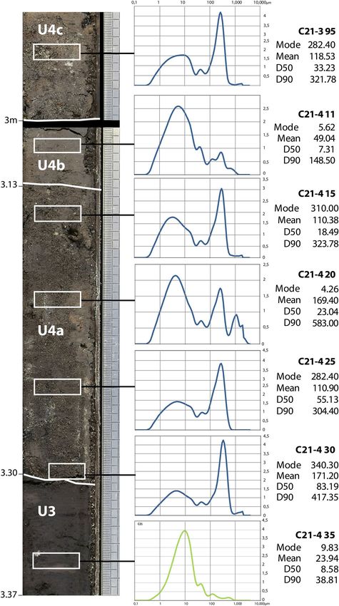
www.nature.com/scientificreports/
Figure 1. Location of the study area and the Eastern Mediterranean geotectonic setting. (a) Red line isopach
(in cm) of the ash layer (2); letter T in black circle: putative tsunami deposits. (b) Black dots, main centres of
the Minoan Crete; White dots, Cretan sites mentioned: 1. Amnisos; 2. Gouves; 3. Palaikastro; 4. Pirgos; Black
triangle, main summits, altitude in meters. Edited in Adobe Illustrator CS6 2020 version 16.0.
on the Northern coast of Crete. Following a first field campaign which revealed the potential of the marsh deposits
for palaeoenvironmental research and a core (C6) that left open the hypothesis of erosion of the marshy deposits
by the Minoan tsunami27, we proceed with a complementary core drilling survey in the archaeological area to
undertake new microfaunal and sedimentological analyses. Shore-landwards transects were drawn to describe
the stratigraphic architecture of the Holocene fill (Fig. 2) in order to determine whether the Bronze Age tsunami
impacted coastal environments at this location and, if so, how extensive this tsunami might have been.
Results
Palaeogeographic reconstruction of the Malia marsh. The marsh of Malia is fed by continental aqui-
fers and mainly corresponds to a freshwater reedbed with a more brackish environment immediately behind
the barrier beach (3.5 m high). The red-ochre Pleistocene sediments of the Malia plain underwent pedogenesis
resulting in a decarbonated brown-reddish soil at the base units of cores C10, C21 and C26 (Fig. 2, symbol 2).
At the beginning of the Late Neolithic, c. 5000 years BCE, dark grey organic silty deposits developed to the
Scientific Reports | (2021) 11:15487 | https://doi.org/10.1038/s41598-021-94859-1 2
Vol:.(1234567890)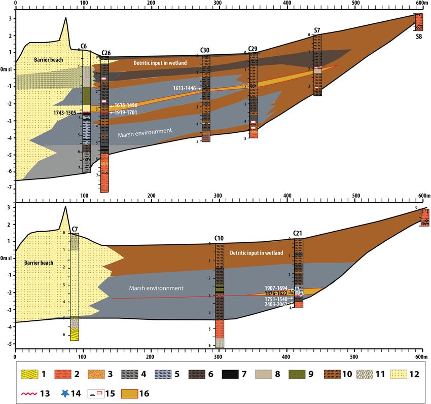
www.nature.com/scientificreports/

                                  Figure 2.  Longitudinal stratigraphy of the Malia marsh and the position of the Late Minoan high energy event,
                                  its absolute chronology data (in years BCE). 1. Pleistocene calcarenites; 2. Pleistocene red-ochre sandy silt; 3.
                                  Pleistocene gravel and sand; 4. Holocene dark grey organic silty clay (gyttja); 5. Holocene dark grey-blue silty
                                  clay; 6. Dark brown silt; 7. Peaty silt; 8. Silty sand layer; 9. Greenish grey sandy clay; 10. Light brown silt; 11.
                                  Coarse sand, gravels and stones; 12. Medium grain-size beach and dune sand; 13. Sharp sedimentary contact;
                                  14. Marine microfaunal elements; 15. Limestone fragments (black triangle) and potsherds (red box); 16. Silty or
                                  sandy sediments attributable to the time period of the Late Minoan high energy event.

                                  northeast (Fig. 2). These are interpreted as the sedimentation of an elongated marsh fed by intermittent streams
                                  behind a coastal barrier formed during the Holocene marine transgression (Fig. 3a, dark applet 7). From 3000
                                  to 2000 years BCE, an extension of the blue-grey to dark-grey silty organic sedimentation occurs landward
                                  along two depressions separated by an elongated hill, south of cores C29 and C21, testifying the development
                                  of the wetland (Fig. 3a). These conditions lasted until the beginning of the Late Minoan (LM) period, circa
                                  1630–1525 years BCE. After the eruption (Fig. 3b), the development of dark grey to greenish grey silty organic
                                  sedimentation shows a landward progression of the marsh southwest into its current form (Figs. 2 and 3b). From
                                  the 1st Millennium BC onwards, the wetland stabilized, with only minor changes.

                                  C21 core. In most cores, macroscopic observations of stratigraphy and sedimentary facies failed to show
                                  evidence of a high-energy sedimentary event. Core C21, however, to the west of the southern end of the marsh
                                  shows a clear signal (Fig. 4). Analysis of the transition from U3 to U5 reveals an abrupt change in the sedimen-
                                  tary facies (Fig. 5). U4 has a sharp basal contact showing an abrupt erosional event with truncation of the under-

Scientific Reports |   (2021) 11:15487 |               https://doi.org/10.1038/s41598-021-94859-1                                                    3

                                                                                                                                                Vol.:(0123456789)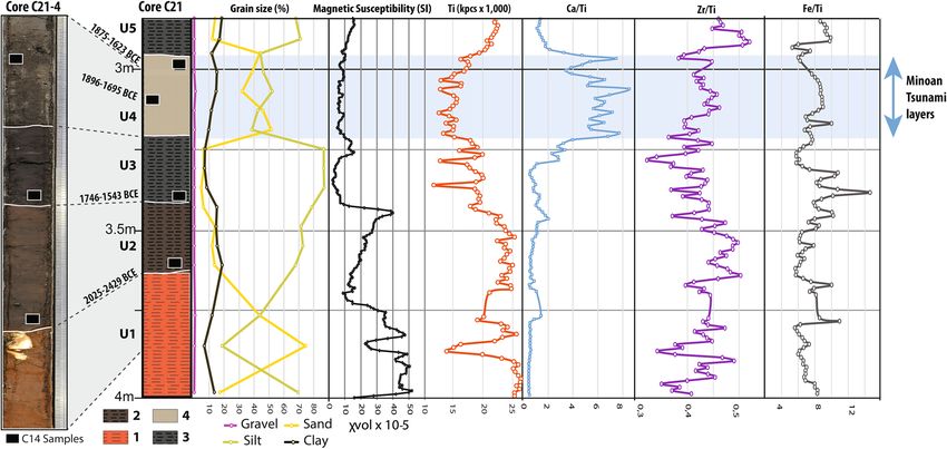
www.nature.com/scientificreports/

                                            Figure 3.  The wetland of Malia before (a: 1800 years BCE) and after (b: 1500 years BCE) the Bronze Age
                                            eruption of the Santorini volcano. A- 1. Hypothetical coastal line (blue) and contour line (grey, 1 m eq.,
                                            elevation indicated for 1–5 m and 10 m contour lines). 2 Cretaceous limestone (Sidheropetra); 3. Pleistocene
                                            deposits; 4. Pleistocene Calcarenite; 5. Beach barrier sand; 6. Sandy marshy deposits; 7. Silt to silty-clay organic
                                            sedimentation: marshy deposits. The dark grey applet on (a) corresponds to the limit of the marsh deposits
                                            c. 5000 BCE; 8. Light brown silt: colluvial and fluvial deposits; 9. Core drillings 2015 (red dot) and ante 2015
                                            (green square); 10. Main excavated area of the Minoan town of Malia. (b) Evidence of tsunami impact; 11.
                                            No clear evidence of tsunami impact; 12. Sharp sedimentary erosional contact; 13. Layer with allochtonous
                                            microfaunal marine fossils; 14. Tsunami deposits; 15. Post-tsunami continental sedimentation. 16. Minoan
                                            buildings cited in the text including the Minoan palace with its central court (white rectangle). Edited in Adobe
                                            Illustrator CS6 2020 version 16.0.

                                            lying dark grey silt marsh deposits (U3). The U4 sand layer is significantly different from these fine silty deposits
                                            (D50: 5–10 µm) which both precede and follow it. The main sand unit is 20 cm thick (U4a), characterized by a
                                            multimodal composition revealing a mixture of well-sorted medium sand and fine silt (D50: 83–18 µm) with a
                                            general normal-graded sequence. It comprises marine mollusks and echinoderms fragments. The next subunit
                                            (U4b) corresponds to a silty layer (D50: 7–8 µm) overlain by a final 6 cm layer of medium sand (U4c) with grain
                                            size characteristics (D50: 33 µm) very close to the main subunit. The sand deposits of U4 also differ from the sur-

          Scientific Reports |   (2021) 11:15487 |               https://doi.org/10.1038/s41598-021-94859-1                                                        4

Vol:.(1234567890)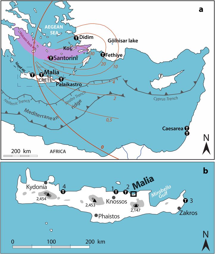
www.nature.com/scientificreports/
Figure 4. Detail of the C21 core (C21-4 and C21-3 section) with radiocarbon sampling locations (black boxes),
grain size, magnetic susceptibility and selection of major elements and geochemical ratios of clastic sources,
carbonate content and redox conditions obtained from XRF core scanner analyses. 1. red-ochre silty Pleistocene
sand; 2. Brown silty-clay; 3. Dark grey organic silty clay; 4. Silty sand layer with marine bioclasts.
rounding silt deposits due to a decrease in titanium (Ti) and, lower magnetic susceptibility than the preceding
marsh deposits, indicating a reduced detrital continental input and pedogenic processes. In contrast, we observe
a high calcium (Ca) to Ti ratio indicating a higher carbonate content, even for the intercalated silty layer (U4b)
partly related to marine components.
Analysis of microfaunal fossils reveals that the units underlying and overlaying U4 (U3 and U5) contain very
few ostracods and foraminifera (Fig. 6; Supplementary Figs. S12–S16). The U4 sand layer however contains an
abundance of both. While some tests are broken, sometimes preventing identification, the overall assemblage
shows a high species diversity. This is particularly the case for the two upper samples (U4-312 & U3-299). U3-299
contains 278 foraminifera, of which 84.5% are benthic and 8.5% are planktonic. All benthic species are typi-
cal of a relatively shallow coastal environment (from lagoon to circalittoral stage) while planktonic species are
indicative of more open sea environments. U4-312 is dominated by benthic species indicating a coastal marine
environment with almost all the individuals living in shallow waters (infra- and/or circa-littoral stages), howevera
few individuals of the genera Cibicides and Cibicidoides are also associated with deeper waters (benthic, inter-
mediate zone). C. Wuellerstorfi (1% of the assemblage) and C. Kullenbergi (1%) in particular are characteristic
of bathyal and abyssal stages.
Ostracod species are much less numerous and diverse than the foraminifera in these sediments. These indicate
a lagoonal environment, Cyprideis torosa prefers s brackish water and lagoons and constitutes the main species
in the three samples, although other lesser indicators of freshwater and other marine environments were also
present.
Origin of the coarse‑grained deposits in core C21. Distinction between storm and tsunami deposits
remains difficult and a subject of debate28–30. Nevertheless, the observations made at Malia offer solid arguments
in favour of tsunami deposition. The high energy deposits of C21 mainly show a 20 cm structureless sand layer
close to the current beach sediment (Supplementary Fig. S11) comprising coastal biogenic elements (U4a) indi-
cating that the beach was the main sedimentary source. Several other characteristics of tsunami deposits were
observed31,33. The deposits were found a long distance inland, more than 400 m from the LM coastline (Fig. 2),
with a strong basal unconformity, normal grading, bimodal grain size distribution and a high carbonate con-
tent. Furthermore, the mixture of intact and broken marine microfossils from both shallow coastal water and
deeper marine environments is also characteristics of tsunami rather than storm deposits32,33. In summary, three
decisive arguments speak in favour of preserved Late Bronze Age tsunamites within the Malia marsh: (1) the
absence of other similar sedimentary events within the Late-Middle Holocene sedimentation of the wetland, (2)
the inner position and spatial discontinuity of the deposits, and (3) the chronology of the sand units comprising
allochthones benthic fauna (see dating section).
The grain-size distribution, ranging from fine to medium sands (Fig. 5), indicates that the flow velocity was
not high but sufficient to transport sand grains in suspension. The clear upward fining from U4a to the thin silty
layer U4c probably results from the phase when the tsunami energy suddenly decreased, i.e. during a settling
phase preceding the backwash or a low-energy backwash. Such sedimentation figures are often described in
Scientific Reports | (2021) 11:15487 | https://doi.org/10.1038/s41598-021-94859-1 5
Vol.:(0123456789)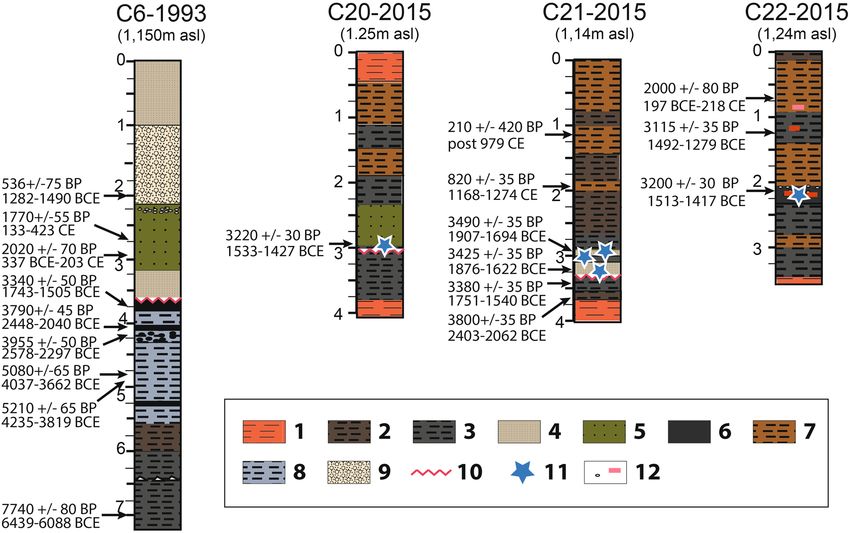
www.nature.com/scientificreports/

                                            Figure 5.  C21 sedimentary facies, grain size distribution and main descriptive statistics of U3 and U4 (high
                                            energy deposits). Photographs of C21-4 and base of C21-3 core sections. U3 deposit (in green) are marshy
                                            deposits ante-event (vertical depth in m, right-hand scale with elementary unit equal to 1 mm).

          Scientific Reports |   (2021) 11:15487 |              https://doi.org/10.1038/s41598-021-94859-1                                                  6

Vol:.(1234567890)
www.nature.com/scientificreports/
Figure 6. Microfaunal content of samples in C21 Core.
tsunami sequences31, even in small e mbayments32. The thin upper silty layer (U4c) could indicate two successive
run-up deposits at C21 separated by a short backwash.
Other core evidence of tsunami impacts. At the fore-shore, only C6 shows evidence of the basal non-
conformity interpreted as the product of the tsunami in C2127. Evidence of tsunami deposits was only found at
the south and east end of the marsh (in C20 and, C22 in addition to C21, Fig. 7). In C20, the general stratigraphic
organization is close to that in C21 (located 20 m west), but there is no sand layer intercalated in the marshy
sedimentation. We observe just a slight change in the color of the sedimentary facies (greenish-grey silt) inter-
calated within the greyish silt. Taken only two centimeters below a well-dated radiocarbon sample (1605–1425
BCE), one silt sample shows an assemblage very close to that observed in the sandy layer of C21. It comprises
57 foraminifera specimens often broken or very abraded corresponding to benthic (80%) and planktonic (5%)
species, while a smaller assemblage of ostracods (14 specimens) is dominated by specimens belonging to a ubiq-
uitous genus (Cladona). A sample taken from the underlying marshy sediment was also characterized by the
absence of microfaunal content consistant with the corresponding layer in C21.
Core C22, located at the eastern end of the marsh, at the bottom of the Minoan town provides further evi-
dence of marine microfauna, including 119 specimens of foraminifera belonging to benthic species representing
an infra-littoral stage (Supplementary Fig. S12). Between 200 and 227 cm below the surface, it displays a silty
sedimentation which shows massive orange–brown silt comprising fine sands with very small gravel, shell frag-
ments, millimeter-sized fragments of ceramics and several charcoal particles. This very compact layer results
from a mixing of sediments from different contexts and a reworking of largely anthropogenic sediments. It was
radiocarbon dated 1526–1417 BCE.
Observation from the other well-dated cores (C23, C25, C26, C28, C29, C30) shows a lack of clear macro-
scopic evidence of truncation of the Holocene sediment and even a very thin sandy layer is absent. Moreover,
for the two other cores that were analyzed at high-resolution (C26, C30), no significant changes attributable to a
high energy event were recorded (“Supplementary Text” and Figs. S4, S5, S9, S10). The sedimentary succession
observed in core C26 (3.5–2.5 m) shows very slight changes in color of the sediment (Supplementary Figs. S9,
S10). A more yellowish-brown silty sedimentary unit (3.27–2.98 m) is intercalated within the greyish layer and
two units dated 1906–1743 BCE and 1616–1458 BCE, respectively. Moreover, the grain-size, magnetic suscepti-
bility and the geochemical analyses undertaken did not show any significant change for this unit. In particular,
there is no detectable change in the carbonate content or sedimentation rate, plus a sample, taken from the upper
gyttja layer dated 1616–1458 BCE, does not contain any microfaunal remains. In C30, continuous macroscopic
sedimentary observations also showed a very tenuous change in the color of the sediment. From 2.2 to 2.0 m deep,
a more yellowish–brown silty sedimentary unit is intercalated in the greyish sediment. It corresponds to a sandier
deposit, but the geochemical analysis shows no change in relative carbonate content. The upper unit (2.0–1.80 m)
is coarser and show peaks in carbonate content (1.95–1.85 m), corresponding to numerous limestone fragments.
Again, microfaunal analyses of this unit, dated 1613–1447 BCE, reveals an absence of ostracods and foraminifera.
Scientific Reports | (2021) 11:15487 | https://doi.org/10.1038/s41598-021-94859-1 7
Vol.:(0123456789)www.nature.com/scientificreports/
Figure 7. Cores showing specific sedimentary features associated with the Late Bronze Age high energy event.
1. Red-ochre silty sand Pleistocene; 2. Brown silty-clay; 3. Dark grey organic silty clay; 4. Silty sand layer with
marine bioclasts; 5. Greenish grey sandy clay; 6. Compact and dense dark clay with many archeological artefacts;
7. Brown silt; 8. Dark grey-blue silty clay; 9. Coarse sand, gravels and stones; 10. Truncation of marshy deposits;
11. Marine microfaunal elements; 12. Limestone fragments (white dot) and potsherds (red line).
Dating the tsunami event. Attempts to directly date tsunami deposits by radiocarbon methods are open
to problems associated with the reworking of older organic matter and biogenic artifacts by the run-up and
backwash of extreme waves. Dating of the non-mixed deposits above and below the tsunamite is the method that
provides the most likely timeframe for their d eposition34. The marshy lower layer (U3) is dated to 1751–1540
BCE in C21, and to 1743–1505 BCE in C6 (Table 1 and Table S1), providing a consistent dating result for the
possible calibrated range of sediments immediately prior to the tsunami. Dated charcoal samples from the sand
layer of C21 produce date ranges which could extend a little earlier, but which are still in overlap with the other
calibrated ranges, at 1876–1622 and 1920–1694 BCE from bottom to top respectively. This inverted pattern and
slightly older dating possibilities are not surprising for what is probably reworked charcoal in the high energy
tsunami deposits. It was not possible to obtain a date immediately after the event on C21, probably because of
erosion or a local hiatus in sedimentation. But, in the C20 and C22 cores, dating of millimeter-sized charcoal
fragments in post-truncation layers gives ages of 1533–1427 and 1513–1417 BCE respectively. These dates come
from charcoal in swampy or anthropogenic sediments that were put in place soon after the event. They are the
earliest candidates for dating the end of the event. From these dates, we use the function “OXcal combine” to
model the pre- and post-event sequences (Supplementary Figs. S6, S7). At 95% confidence ranges, there is no
overlapping of the two sequences. For the pre-event layer, we obtain a possible time-window of 1744–1544 BCE
(with 87.6% probability in the period 1741–1606 BCE) while for the post-event layer, we obtain the interval
1509–1430 BCE. Additionally, the dates obtained at Malia have some overlap with two dates obtained at Göl-
hisar Lake in Turkey for the peat immediately underlying the Bronze Age tephra layer, of 1744–1431 BCE and
1611–1415 BCE35, providing an Oxcal combined date of 1612–1436 BCE (Supplementary Figs. S8 and Table S2).
Comparison of these dates with new radiocarbon dates obtained from archaeological contexts in the town of
Malia shows good agreement. Of five radiocarbon dates from LM IA layers at Malia (Table 2), two were obtained
from short-lived samples from a mature LM IA phase context in the Pi excavation a rea36 (Fig. 3B) and provide a
calibrated age range of 1633–1501 BCE. The archaeological material in this phase is contemporaneous with that
of the last period of occupation at Akrotiri on the island of S antorini6. Thus, this archaeological phase dating to
the mature phase of LM IA is broadly contemporaneous with the Minoan eruption of the Santorini volcano. We
can conclude that the most probable time bracket for the high energy event identified in the Malia marsh is during
the sixteenth century BCE. This is consistent with date ranges based on calibrations of key radiocarbon dating
evidence from immediate pre-eruption contexts on Santorini to IntCal20 and also with radiocarbon dates from
the site of Tell el-Ajjul, Gaza, found in association with Santorini pumice, and compatible with archaeological
interconnections with Egypt12. Moreover, recent high resolution studies of Antarctic and Greenland ice have
begun to exclude the possibility of a seventeenth century BCE date for the Thera eruption and suggest instead
a focus on the period 1570–1500 BCE to look for volcanic ash in the Greenland ice cores37. This move towards
Scientific Reports | (2021) 11:15487 | https://doi.org/10.1038/s41598-021-94859-1 8
Vol:.(1234567890)www.nature.com/scientificreports/
Site Core trench Depth (m) Material 14
C age Error 1σ Error 2σ Cal. BCE 1σ Cal. BCE 2σ Recalibration BCE References
Malia (Crete)
C21 2.99 Charcoal 3425 35 1865–1641 1876–1622 This study
Tsunamites
Malia (Crete)
C21 3.22 Charcoal 3490 35 1880–1751 1920–1694 This study
Tsunamites
Malia (Crete) Pre-
C6 3.755 Peat 3340 50 1682–1537 1743–1505 This study
tsunami
Malia (Crete) Pre-
C21 3.44 Gyttja 3380 35 1736–1621 1751–1540 This study
tsunami
Malia (Crete) Pre-
C21 3.67 Gyttja 3800 35 2290–2149 2429–2065 This study
tsunami
Malia (Crete) Post-
C20 2.97 Charcoal 3220 30 1507–1148 1533–1427 This study
tsunami
Malia (Crete) Post-
C22 2.11 Charcoal 3200 30 1499–1444 1513–1417 This study
tsunami
Didim (Turkey) Benthic foraminif- Minoura et al.
C1 1.15 3837 88 NP 1930–1706 NP 2070–1413
Tsunamites era (2000)16
Didim (Turkey) Benthic foraminif- Minoura et al.
C1 1.15 3886 86 NP 1991–1759 NP 2134–1474
Tsunamites era (2000)16
Fetihye (Turkey) Minoura et al.
C2 1.6 Marine shell 4303 79 NP 2562–2351 NP 2683–2006
Tsunamites (2000)16
Palaikastro (Crete) Bone (cattle, col- Bruins et al.
PR1 NA 3310 35 NP NP 1684–1503
Tsunamites lagen) (2008)17
Palaikastro (Crete) Bone (cattle, col- Bruins et al.
PR2 NA 3390 35 NP NP 1867–1544
Tsunamites lagen) (2008)17
Palaikastro (Crete) Bruins et al.
PR2 NA Shell (Patelidae) 3790 35 NP NP 1817–1303
Tsunamites (2008)17
Caesarea (Israel) Goodman-Tcher-
C1 0.9 Foraminifera 3610 40 NP 1660–1460 1821–1316
Tsunamites nov et al. (2009)22
Caesarea (Israel) Goodman-Tcher-
C2 1.3 Foraminifera 3640 40 NP 1680–1490 1866–1396
Tsunamites nov et al. (2009)22
Table 1. Radiocarbon dates of samples attributed to the Minoan tsunami deposits in their chronological
context in Malia (pre- and post-tsunami) and in the wider Eastern Mediterranean. Calibrations or
recalibrations are based on OxCal v4.3.2 and datasets IntCal-20 and Marine20 for foraminifera and marine
shells (see “Supplementary Text”).
Archaeological Archaeological
Excavation area context chronology Material C age
14
Error 2σ Cal 2σ Sample code References
Square A4, 4th level, Delibrias et al. (1970) ;
Epsilon Late Minoan 1A Charcoal 3200 250 2132–836 BCE Gif-256
post-destruction Pelon et al. (1992)
Late Minoan 1A Charcoal Amygdalus Lyon-5070 (SacA-
Abords Nord-Est Room 20.2 3315 35 1886–1504 BCE Darcque (2014)39
(early or mature) Communis 11021)
Late Minoan 1A
Destruction of build- (late phase) or Late Charcoal Amygdalus Lyon-5072 (SacA-
Abords Nord-Est 1770 30 1505–1397 BCE Darcque (2014)39
ing 10B (level 11) Minoan 1B (early Communis 11023)
phase)
Statigraphical unit Late Minoan 1A Lyon-17504 (SacA-
Pi Olea europaea 3290 30 1622–1501 BCE This study
4.030, space 11 (mature) 60294)
Stratigraphical unit Late Minoan 1A Lyon-17505 (SacA-
Pi Olea europaea 3290 30 1622–1501 BCE This study
4.063, space 16 (mature) 60295)
Table 2. Available radiocarbon dates of samples from the archaeological layers attributed to the LM-1A phase
in Malia.
the sixteenth century BCE is in line with our dating results for the Malia tsunami. Unfortunately, because of the
plateau in the calibration curve and the standard deviation, these results emphasize that palaeoenvironmental
records with higher resolution will be needed to indisputably pinpoint the exact date of this event9.
Tsunami impact at Malia. Run-up height, inundation distance and spatial extension of the erosion and
deposition pattern are the key elements to determine the impact of a tsunami. The observations made in Malia
suggest that the tsunami was mainly characterized by lower scale erosion of the marshy sediment and deposition
to the south and east end of the marsh. This suggests a predictable decrease in the wave energy towards the south
and east of the marsh, perhaps in connection with a northwest-southeast oriented wave train. The decreasing
force seen at C22 could be explained by localized effect of a slope of about 10 m separating the marsh from the
Scientific Reports | (2021) 11:15487 | https://doi.org/10.1038/s41598-021-94859-1 9
Vol.:(0123456789)www.nature.com/scientificreports/
plateau of Malia town, contrary to the area of C21 where the slopes of the Pleistocene fan gradually rise north-
wards. We note that overall, the event layer is thin and has not been observed (to date) further inland. After the
eruption, light brown silt deposits (C30, C29, C22, C26) indicate an increase of detrital continental input to the
east (Fig. 3B), whereas to the west the persistence of organic silt and peat deposits indicate the relative weakness
of colluvial and alluvial inputs.
The archaeological excavation closest to the barrier beach (with LM1A occupation) is the Theta House, around
6 m asl38. The Neopalatial levels were eroded and badly preserved but some Neopalatian vases found during the
excavation were found complete. Nothing in the record of the Neopalatial material suggests a chaotic layer of
destruction that might indicate an effect from the tsunami. Unfortunately, this excavation was carried out some
time ago and is too inaccurate to be conclusive one way or the other about the impact of the tsunami. However,
so far we must underline that any evidence of the tangible impact of a tsunami is also missing from numerous
excavations conducted in the center of the Malia town. The observed destruction of the late LM-1A or early
LM-1B is unrelated to the impacts of the tsunami as the destruction of building 10B at the north-eastern edge
of the palace falls within the 1505–1397 BCE range (Table 2), later than the eruption of S antorini39. Therefore,
the tsunami did not impact the main part of the Minoan town established on the plateau, or most of the Minoan
settlements of Northern C rete40 including the centre of the town of P
alaikastro41. As the center of the Minoan
town is located about 400 m to the east and 8–14 m above the current sea level (asl), it suggests a maximum
height for the run-up surge of less than 8 m asl. The definition of the LM relative sea level is difficult in an active
tectonic context and the position of the LBA shoreline remains highly hypothetical. Nevertheless, we know that
the top of the marsh sedimentation today is around 0.7–0.8 m meters above sea level and it is in equilibrium
with the groundwater level which is controlled by the current sea level. This indicates that the marshy depos-
its are probably ± 1 m in relation to the sea level. As, the marsh deposits preceding the tsunami were around
2.5–1.75 m bsl, this provides an approximation of the Late Minoan sea level (msl). Moreover, this estimation is
close to the observations made for eastern-central Crete which suggest a sea level 2–3 m below the present one
at the time of the Santorini eruption42. Therefore, the maximum run-up of the tsunami was probably less than
10 m above the Late Minoan sea level (msl), and the wave height at the coastline would have been much less. In
the flat area of the Malia marsh, the inundation distance was probably up to 500 m, but also with only modest
geomorphological consequences.
Other Bronze Age tsunami candidates and their chronology. Most of the older, less precise reports
regarding tsunami deposits have been largely rejected today, such as those from northern Crete at sites in
Amnisos24 and Gouves16 or on the Levant c oast43. These relied on limited observations making the interpreta-
tion of the deposit doubtful21,23. Suspected thin tsunami deposits have also been identified in coastal plains of
eastern Sicilia44 and in north-west Crete45, but another origin has been suggested for the former19 and the latter is
not directly dated. Both also remain difficult to distinguish from storm deposits in sequences comprising several
other high energy marine deposits.
Five deposits attributed to the Minoan tsunami have been adequately described16,17,23,46 but published dates
have been obtained mainly from the tsunami deposits themselves and illustrate the hazards of dating of mixed
age samples in tsunami deposits. The results are questionable and wide-ranging (Table 1). On the Turkish coast
plain near Didim and Fethiye, marine sand deposits of 10–15 cm thickness, directly overlain by a tephra layer,
1–1.5 m bsl and 60 and 120 m inland of the current coastline respectively16. In the case of Fethiye, the dating
control is weak because of the very old date associated with the tsunami deposits (2683–2006 BCE). In fact, the
attribution to the LBA period is mainly based on the refractive-index measurements and the XRF chemistry of
the overlying tephra which is argued to be consistent with the Santorini eruption. The Didim deposit is more
convincing. The stratigraphic position is close to the one observed at Fethiye and the dates obtained in the tsu-
namites are very close to those obtained in the Malia tsunamites, even if the margins of error remain too large.
In the outskirts of the Minoan site of Palaikastro, at the east end of Crete (150 km south of Santorini), an
unsorted chaotic layer of coastal gravel, sand, and marine bioclasts, with building stones, ceramic sherds and
ash inclusions was interpreted as a tsunami d eposit17. This deposit extends over 100 m at the top of a low coastal
cliff above the Chiona beach, but no evidence further inland has yet been reported. The maximum run-up height
was estimated around 9 m asl. However, we cannot exclude that the observed chaotic layer is partly the result of
heavy rainstorms17 and associated continental flash floods which are frequent in Crete, for these can generate
this kind of chaotic layer23. The abundant LM IA artefacts (pottery sherds, architectural and faunal remains)
show that the wave must have passed through densely inhabited spaces that are now eroded or submerged, but
so far there has been no research to attest such a dynamic. Two of the three radiocarbon dates were obtained
from archaeological material (animal bones of different ages) from a layer comprising numerous LM IA artifacts.
In our opinion these should be considered for their capacity to date the rich local archaeological context rather
than the extreme marine event. Moreover, the same layers comprise older marine shells (2550–2000 BCE) and
marine gastropods dated to 2000–1300 BCE that are interpreted as “storms or later tsunami [that] could have
dropped these shells”17 (p. 207), which raises doubts about the unique origin of all the deposits. The older shell
assemblages overlap in time range with the older dates associated with the Fethiye tsunami deposits. While in
both cases it is argued that these significantly older dates relate to older material mixed up in the tsunami, it is
also possible that the assemblage dates to an earlier event.
Tsunami deposits from submerged sediment cores taken offshore from Caesarea, Israel have been suggested to
mark the maximum extent of the Minoan tsunami in the East M editerranean23 although these deposits could also
have their origin in a landslide-induced tsunami, occurring in the eastern area of the Nile D elta19. Radiocarbon
date ranges for the up to 40 cm thick submarine deposit at Caesarea are large because of dating uncertainties in
the marine reservoir age, but could match the approximate time span for the Minoan eruption and overlap the
Scientific Reports | (2021) 11:15487 | https://doi.org/10.1038/s41598-021-94859-1 10
Vol:.(1234567890)www.nature.com/scientificreports/
dates from Malia. Arguably the most secure Minoan eruption tsunami evidence comes from the eastern coast
of Santorini itself, where a thick tephra layer from the last eruption phase has been interpreted as reworked by
the volcanogenic tsunami, with a reported run up of 6 m asl46, quite consistant with the more modest impacts
seen at Malia.
To conclude, models proposing wave heights much higher than 8 m asl for northern Crete would seem at this
current time to be overestimations and those concluding higher tsunami wave height in northern Crete than in
eastern Crete must be questioned16,18,19. More precise and localized analysis of run-up heights and inundation
extents will allow us to understand the full consequences of the tsunami on cultivated and inhabited areas, but
indications from Malia are that the impacts of the Minoan tsunami were relatively modest. The Malia evidence
opens the field for new research on the event, specifically by illustrating that tsunami evidence can be found in
positions further away from the present coastline than may previously have been considered in numerous coastal
plains of northern-central and eastern Crete. These should be the focus for future investigations.
Materials and methods
In 2015, permission was obtained to proceed with a new core drilling survey in the archaeologically significant
area of the Malia marsh, to build on preliminary findings, especially in the eastern part of the marsh, closest
to the Minoan town, a full geomorphological study. Eleven 50-mm-diameter cores were obtained from up to a
maximum depth of 8 m below the surface using a hand-driven vibrocorer (Cobra TT) and hydraulic extractor.
Each core was located using a Leica differential Global Navigation Satellite System (GS15 type). The acquisi-
tion of points was carried out in real time kinematic (RTK) using a network (SmartNet) of fixed antennas from
the access provider. The points were recorded in the Greek EGSA87 system. The topography of the study area
was obtained from a combination of the 1/5000 Greek army plan (GYS) (ref. 9622/2) and archaeological maps
from the French School of Athens derived from the digitization of photogrammetric plans made in 1990 by the
Polytechnic School of Athens. The reference zero is that of the tide gauge of Piraeus and corresponds to mean
sea level 0. The tide range in Malia ranges from 10 to 30 cm. Cores C26 and C25 were duplicated and three cores
were extracted with an open open-barrel and described and sampled in the field (C20, C22, C29). For other
cores, PVC core liners were inserted inside a rigid one-meter-long core barrel that included a core-catcher. Liners
were shipped to the laboratory and split using a vibratory cutter to describe the sedimentary facies’ succession
for each core and to sample the selected ones.
50 AMS radiocarbon dates were obtained from gyttja (organic clay) and millimeter-sized charcoal (1–2 mm)
material, with 12 AMS dates specifically for the period 2500–1500 BCE. Calibration or recalibration of each
date was based on OxCal v4.3.247 and datasets IntCal 2 048 and Marine2049 for foraminifera and marine shells
(“Supplementary Text” and Tables S1, S2). We used the same protocol to re-calibrate the dates obtained from
just below the Late Bronze age Santorini ash layer from cores obtained at Gölisar Lake in South Turkey35 and
the available dates of the LM Phase 1A obtained in Malia (Table 2). The chronostratigraphy of the Holocene fill
was reconstructed from the description of the successive sedimentary facies and the chronology obtained from
radiocarbon dates for each core (Figs. S4–S6).
Three cores were sampled every 5 cm for sedimentological analyses. The grain size distribution was meas-
ured by laser diffraction with a Beckman-Coulter LS230 on C21, C26 and C30 cores (“Supplementary Text”).
Magnetic susceptibility was used to identify traces of paleopedogenesis and organic matter accumulation, oxi-
dation–reduction and detrital phases enriched in magnetic minerals or in a fine fraction inherited from old
fersiallitic soils surrounding the marsh. Each core was measured twice every 0.5 cm using a MS2F Bartington
Susceptibility Meter. The value of each measurement was multiplied by 0.5 to correct for variations in sensitivity
around the probe head. Resulting values corresponded to the mean of the two corrected measurements and are
equal to χvol × 10–5 S.
To estimate relative concentrations of major and trace elements in three cores (“Supplementary Text”—
Figs. S9, S10), we measured elemental intensity using scanning X-ray fluorescence spectrometry (XRF) via
an Avaatech core scanner. XRF measurements do not provided concentrations of elements, but the uncali-
brated values produced can be used as estimates of the relative concentrations to provide paleoenvironmental
information50. Ti is considered as a proxy of terrigenous silicate input as it is strictly of terrigenous origin. It is
mainly present in clay minerals while Zr ranks among heavy minerals and is more often associated with coarser
silt and sand-size f ractions51,52 related to high-energy e nvironments53 and coastal sandy d eposits54. We used
the Zr/Ti ratio as a grain size proxy to identify less visible changes in the sedimentation process and potential
coastal input. Ca indicates detrital carbonate deposition and/or the carbonate precipitation signal. We used the
Ca/Ti ratio to normalize changes in Ca relative to a clastic source and to detect authigenic carbonate or marine
input because the beach is characterized by medium carbonate sand. Changes in Fe can indicate change in redox
conditions in the marsh as precipitation of the Fe oxide signal can relate to the oxygenation p rocesses55,56 but it
can also be indicative of clastic input. Na, Cl and S were too close to detection limits to be considered.
Microfossil analyses were conducted on 22 samples distributed across five cores (C20, C21, C22, C26, C30)
in order to determine microfossil content of the sedimentary layers attributed to the eruption period and to
identify allochthonous deposits within the marsh (Fig. S12). For each sample, 7 cm3 of sediment was taken from
a 5 cm diameter half core and sieved at 50 μm. The sieve residue was dried naturally. Individual fossils were
isolated and photographed using a Leica M205C binocular loupe and a conventional scanning electron micro-
scope Zeiss EVO 10 (Figs. S13–S16). Due to the relatively small amount of sediment treated, individuals were
systematically counted. The fossil ostracods and foraminifa were isolated and photographed. Their identification
and the definition of their ecological characteristics was determined using regional references57–66. Taxonomy
was defined using the international taxonomic registers WoRMS (World Register of Marine Species) and PESI
(Pan-European Species-directories Infrastructure).
Scientific Reports | (2021) 11:15487 | https://doi.org/10.1038/s41598-021-94859-1 11
Vol.:(0123456789)www.nature.com/scientificreports/
Received: 23 March 2021; Accepted: 16 July 2021
References
1. Poursat, J. C. Malia: Palace, State, City 259–267 (British School at Athens Studies, 2010).
2. Johnston, E. N., Phillips, J. C., Bonadonna, C. & Watson, I. M. Reconstructing the tephra dispersal pattern from the Bronze Age
eruption of Santorini using an advection–diffusion model. Bull. Volcanol. 74(6), 1485–1507 (2012).
3. Druitt, T. H., McCoy, F. W. & Vougioukalakis, G. E. The Late Bronze Age eruption of Santorini volcano and its impact on the
ancient Mediterranean world. Elements Int. Mag. Mineral. Geochem. Petrol. 15(3), 185–190 (2019).
4. Evans, K. J. & McCoy, F. W. Precursory eruptive activity and implied cultural responses to the Late Bronze Age (LBA) eruption of
Thera (Santorini, Greece). J. Volcanol. Geothermal Res. 397, 106868 (2020).
5. Nomikou, P. et al. Post-eruptive flooding of Santorini caldera and implications for tsunami generation. Nat. Commun. 7(1), 1–10
(2016).
6. Doumas, C. G., Palyvou, K., Devetzi, A. & Boulotis, C. Akrotiri, Thera 17th century BC: A Cosmopolitan Harbour Town 3500 Years
Ago (Society for the Promotion of Studies on Prehistoric Thera, 2015).
7. Pyle, D. M. New volume estimates for the Minoan eruption. In Thera and the Aegean World III (eds Hardy, D. et al.) 113–121 (The
Thera Foundation, 1990).
8. Cita, M. B. & Aloisi, G. Deep-sea tsunami deposits triggered by the explosion of Santorini (3500 y BP), eastern Mediterranean.
Sed. Geol. 135(1–4), 181–203 (2000).
9. Pearson, C. L. et al. Annual radiocarbon record indicates 16th century BCE date for the Thera eruption. Sci. Adv. 4(8), eaar8241
(2018).
10. Pearson, C. L. et al. Annual variation in atmospheric 14C between 1700 BC and 1480 BC. Radiocarbon 62(4), 939–952 (2020).
11. van der Plicht, J., Ramsey, C. B., Heaton, T. J., Scott, E. M. & Talamo, S. Recent developments in calibration for archaeological and
environmental samples. Radiocarbon 62(4), 1095–1117 (2020).
12. Bietak, M. & Höflmayer, F. High and low chronology in The Synchronisation of Civilisations in the Eastern Mediterranean in the
Second Millennium B.C. III (eds. Bietak, M., & Czerny, E.) 13–24 (Verlag der Österreichischen Akademie der Wissenschaften,
2007).
13. Wiener, M. H. & Warburton, D. A. The state of the debate about the date of the Theran eruption. In Time’s Up. Dating the Minoan
Eruption of Santorini (ed. Warburton, D. A.) 197–206 (Aarhus University Press, 2009).
14. Friedrich, W. L. et al. Santorini eruption radiocarbon dated to 1627–1600 BC. Science 312(5773), 548–548 (2006).
15. Manning, S. W. et al. Chronology for the Aegean Late Bronze Age 1700–1400 BC. Science 312(5773), 565–569 (2006).
16. Minoura, K. et al. Discovery of Minoan tsunami deposits. Geology 28(1), 59–62 (2000).
17. Bruins, H. J. et al. Geoarchaeological tsunami deposits at Palaikastro (Crete) and the Late Minoan IA eruption of Santorini. J.
Archaeol. Sci. 35(1), 191–212 (2008).
18. Novikova, T., Papadopoulos, G. A. & McCoy, F. W. Modelling of tsunami generated by the giant late Bronze Age eruption of Thera,
South Aegean Sea, Greece. Geophys. J. Int. 186(2), 665–680 (2011).
19. Periáñez, R. & Abril, J. M. Modelling tsunamis in the Eastern Mediterranean Sea. Application to the Minoan Santorini tsunami
sequence as a potential scenario for the biblical Exodus. J. Mar. Syst. 139, 91–102 (2014).
20. Athanassas, C. D., Modis, K., Alçiçek, M. C. & Theodorakopoulou, K. Contouring the cataclysm: A geographical analysis of the
effects of the minoan eruption of the Santorini Volcano. Environ. Archaeol. 23(2), 160–176 (2018).
21. Dominey-Howes, D. A. Re-analysis of the Late Bronze Age eruption and tsunami of Santorini, Greece, and the implications for
the volcano–tsunami hazard. J. Volcanol. Geoth. Res. 130(1–2), 107–132 (2004).
22. Goodman-Tchernov, B. N., Dey, H. W., Reinhardt, E. G., McCoy, F. & Mart, Y. Tsunami waves generated by the Santorini eruption
reached Eastern Mediterranean shores. Geology 37(10), 943–946 (2009).
23. Driessen, J. The Santorini eruption. An archaeological investigation of its distal impacts on Minoan Crete. Quat. Int. 499, 195–204
(2019).
24. Marinatos, S. The volcanic destruction of Minoan Crete. Antiquity 13(52), 425–439 (1939).
25. Driessen, J. & Macdonald, C. The Troubled Island. Minoan Crete Before and After the Santorini Eruption (Peeters Publishing,
Aegaeum Series 17, 1997).
26. Friedrich, W. L. The Minoan eruption of Santorini around 1613 BC and its consequences. Tagungen des Landesmuseums für
Vorgeschichte Halle 9, 37–48 (2013).
27. Lespez, L. et al. Late-Middle-Holocene palaeo-environmental evolution and coastline changes of Malia (Crete). In The Mediter-
ranean World Environment and History (ed. Fouache, E.) 439–452 (Elsevier, 2003).
28. Marriner, N. et al. Tsunamis in the geological record: Making waves with a cautionary tale from the Mediterranean. Sci. Adv. 3(10),
e1700485 (2017).
29. La Selle, S. et al. Sedimentary evidence of prehistoric distant-source tsunamis in the Hawaiian Islands. Sedimentology 67(3),
1249–1273 (2020).
30. Costa, P. J. & Andrade, C. Tsunami deposits: Present knowledge and future challenges. Sedimentology 67(3), 1189–1206 (2020).
31. Shiki, T., Tsuji, Y., Minoura, K. & Yamazaki, T. Tsunamiites—Features and Implications (Elsevier Science, 2008).
32. Hawkes, A. D. et al. Sediments deposited by the 2004 Indian Ocean tsunami along the Malaysia-Thailand Peninsula. Mar. Geol.
242(1–3), 169–190 (2007).
33. Mamo, B., Strotz, L. & Dominey-Howes, D. Tsunami sediments and their foraminiferal assemblages. Earth Sci. Rev. 96(4), 263–278
(2009).
34. Ishizawa, T., Goto, K., Yokoyama, Y. & Goff, J. Dating tsunami deposits: Present knowledge and challenges. Earth-Sci. Rev. 200,
102971 (2020).
35. Eastwood, W. J., Tibby, J., Roberts, N., Birks, H. J. B. & Lamb, H. F. The environmental impact of the Minoan eruption of Santorini
(Thera): Statistical analysis of palaeoecological data from Golisar, southwest Turkey. Holocene 12(4), 431–444 (2002).
36. Pomadere, M., Lespez, L. & Langhor, C. Times of historical developments and environmental changes in the Minoan town of
Malia, Crete: An intra and off-site geoarcheological approach. In Different times? Archaeological and Environmental Data from
Intra-site and Off-site Sequences (eds Tsirtsoni, Z. et al.) 64–76 (Proceeding of the 18th UISSP International Congress Paris, British
Archaeological Reports, 2020).
37. Cole-Dai, J. et al. Comprehensive record of volcanic eruptions in the Holocene (11,000 years) from the WAIS Divide, Antarctica
ice core. J. Geophys. Res. Atmos. 126(7), e2020JD032855 (2021).
38. Van Effenterre, H., Van Effenterre, M. Fouilles exécutées à Mallia. Exploration des maisons et quartiers d’habitation (1956–1960).
IV, Le quartier Thêta. (Etudes crétoises 22, Ecole Française d’Athènes, 1976).
39. Darcque, P., Van de Moortel, A. & Schmid, M. Les abords Nord-Est du palais I. Les recherches et l’histoire du secteur (Études crétoises
35, École française d’Athènes, 2014).
40. Soles, J. S., McCoy, F. W. & Suka, R. Evidence for three earthquakes at Mochlos in the Neopalatial period, c. 1700–1430 BC. In
Minoan Earthquakes, Breaking the Myth through Interdisciplinarity (eds Jusseret, S. & Sintubin, M.) 307–325 (Studies in Archaeo-
logical Sciences 5, Leuven University Press, 2017).
Scientific Reports | (2021) 11:15487 | https://doi.org/10.1038/s41598-021-94859-1 12
Vol:.(1234567890)www.nature.com/scientificreports/
41. Kulick, R. & Westgate, J. Tephrochronology and micromorphology of Theran tephra deposits at Palaikastro. Crete. J. Archaeol. Sci.
Rep. 36, 102884 (2021).
42. Mourtzas, N., Kolaiti, E. & Anzidei, M. Vertical land movements and sea level changes along the coast of Crete (Greece) since Late
Holocene. Quatern. Int. 401, 43–70 (2016).
43. Pfannenstiel, M., Erlaüterungen zu den bathymetrischen Karten des östlichen Mittelmeeres. Bulletin de l’Institut Ocean-
ographique 1192, 1–60 (1960).
44. De Martini, P. M. et al. A unique 4000 yearlong geological record of multiple tsunami inundations in the Augusta Bay (eastern
Sicily, Italy). Mar. Geol. 276(1–4), 42–57 (2010).
45. Werner, V. et al. Mid-Holocene tectonic geomorphology of northern Crete deduced from a coastal sedimentary archive near
Rethymnon and a Late Bronze Age Santorini tsunamite candidate. Geomorphology 326, 167–189 (2019).
46. McCoy, F. W. & Heiken, G. Tsunami generated by the Late Bronze age eruption of Thera (Santorini), Greece. Pure Appl. Geophys.
157(6–8), 1227–1256 (2000).
47. Bronkramsey, C. OxCal Program, Version 4.3 (Oxford Radiocarbon Accelerator Unit, University of Oxford, 2017).
48. Reimer, P. J. et al. The IntCal20 Northern Hemisphere radiocarbon age calibration curve (0–55 cal kBP). Radiocarbon 62(4),
725–757 (2020).
49. Heaton, T. J. et al. Marine20—The marine radiocarbon age calibration curve (0–55,000 cal BP). Radiocarbon 62(4), 779–820 (2020).
50. Lu, Y. et al. Trends in catchment processes and lake evolution during the late-glacial and early-to mid-Holocene inferred from
high-resolution XRF data in the Yellowstone region. J. Paleolimnol. 58(4), 551–569 (2017).
51. Kylander, M. E., Ampel, L., Wohlfarth, B. & Veres, D. High-resolution X-ray fluorescence core scanning analysis of Les Echets
(France) sedimentary sequence: new insights from chemical proxies. J. Quat. Sci. 26(1), 109–117 (2011).
52. Liu, W., Li, X., An, Z., Xu, L. & Zhang, Q. Total organic carbon isotopes: A novel proxy of lake level from Lake Qinghai in the
Qinghai-Tibet Plateau, China. Chem. Geol. 347, 153–160 (2013).
53. Chagué-Goff, C., Szczuciński, W. & Shinozaki, T. Applications of geochemistry in tsunami research: A review. Earth Sci. Rev. 165,
203–244 (2017).
54. Degeai, J. P. et al. Fluvial response to the last Holocene rapid climate change in the Northwestern Mediterranean coastlands. Glob.
Planet. Change 152, 176–186 (2017).
55. Sabatier, P. et al. 6-kyr record of flood frequency and intensity in the western Mediterranean Alps-Interplay of solar and temperature
forcing. Quatern. Sci. Rev. 170, 121–135 (2017).
56. Żarczyński, M., Wacnik, A. & Tylmann, W. Tracing lake mixing and oxygenation regime using the Fe/Mn ratio in varved sediments:
2000 year-long record of human-induced changes from Lake Żabińskie (NE Poland). Sci. Total Environ. 657, 585–596 (2019).
57. Barbeito-Gonzalez, P. J. Die Ostracoden des Kiistenbereiches yon Naxos (Griechcnland) und ihre Lebensbereiche. Mitt. Hamburg
Zool. Mus. Inst. Hamburg 67, 255–326 (1971).
58. Henderson, P.A. Freshwater ostracods: keys and notes for the identification of the species (Balogh Scientific Books, Linnean society
of London and the estuarine and coastal sciences association, 1990).
59. Triantaphyllou, M. V., Tsourou, T., Koukousioura, O. & Dermitzakis, M. D. Foraminiferal and ostracod ecological patterns in
coastal environments of SE Andros Island (Middle Aegean Sea, Greece). Rev. Micropaléontol. 48(4), 279–302 (2005).
60. Valls, L., Zamora, L., Rueda, J. & Mesquita-Joanes, F. Living and dead ostracod assemblages in a coastal mediterranean wetland.
Wetlands 36(1), 1–9 (2016).
61. Cimerman, F. & Langer, M. R. Mediterranean Foraminifera (Slovenska Akademija Znanosti, 1991).
62. Dimiza, M. D., Koukousioura, O., Triantaphyllou, M. V. & Dermitzakis, M. D. Live and dead benthic foraminiferal assemblages
from coastal environments of the Aegean Sea (Greece): Distribution and diversity. Rev. Micropaléontol. 59(1), 19–32 (2016).
63. Frontalini, F., Kaminski, M. A., Mikellidou, I. & du Châtelet, E. A. Checklist of benthic foraminifera (class Foraminifera: d’Orbigny
1826; phylum Granuloreticulosa) from Saros Bay, northern Aegean Sea: A biodiversity hotspot. Mar. Biodivers. 45(3), 549–567
(2015).
64. Holbourn, A., Henderson, A. S. & MacLeod, N. Atlas of Benthic Foraminifera (Wiley, 2013).
65. Koukousioura, O. et al. Benthic foraminiferal evidence and paleoenvironmental evolution of Holocene coastal plains in the Aegean
Sea (Greece). Quatern. Int. 261, 105–117 (2012).
66. Milker Schmiedl, Y. G. A taxonomic guide to modern benthic shelf foraminifera of the western Mediterranean Sea. Palaeontol.
Electron. 15(2), 1–134 (2012).
Acknowledgements
The research was conducted in the framework of two research programs. The “Paleomex” project which is part
of the MISTRALs Research program funded by the “Institut National des Sciences de l’Univers (INSU)” and
“Institut National de l’Ecologie et de l’Environnement (INEE)” from the French “Centre National de la Recherche
Scientifique (CNRS)”. The project conducted on the marsh area at Malia was also funded by the French School
at Athens. Particularly, we warmly thank Lionel Fadin (EFA) for the acquisition of topographic data. We would
also like to thank the Ephorate of Antiquities of Heraklion for its support (Ministry of Culture & Sport, Greece).
Additional funding for the present study was obtained from the “Institut Universitaire de France” in the frame
of a project held by Laurent Lespez and from the Labex DynamiTe (ANR-11-LABX-0046). XRF measurements
were performed at the EPOC (Université de Bordeaux, CNRS) and EDYTEM (Université Savoie-Mont-Blanc,
CNRS) laboratories (France) and we thank Isabelle Billy and Anne-Lise Develle. Microscopic observations were
performed thanks to the platform “Archeoscopie” of the “MSH Mondes” at Nanterre (France) and we wish to
thank particularly Jessica Legendre. We warmly thank Dr David R Tappin and Dr. Floyd McCoy for their con-
structive review which allowed us to greatly improve a first version of this paper.
Author contributions
L.L., M.P. and S.M.C. designed the research; L.L., A.G., J.-F.B., C. V., F.L. and M.P. performed the field investiga-
tions; S.L., S.S.-C., J.-F.B. and L.L. performed data; S.L., J.-F.B., C.P., F.L., S.M.C., M.P. and L.L. analyzed data;
L.L. wrote the paper and English language editing by C.P.
Competing interests
The authors declare no competing interests.
Additional information
Supplementary Information The online version contains supplementary material available at https://doi.org/
10.1038/s41598-021-94859-1.
Scientific Reports | (2021) 11:15487 | https://doi.org/10.1038/s41598-021-94859-1 13
Vol.:(0123456789)You can also read