Younger Dryas ice margin retreat in Greenland: new evidence from southwestern Greenland - Recent
←
→
Page content transcription
If your browser does not render page correctly, please read the page content below
Clim. Past, 17, 587–601, 2021
https://doi.org/10.5194/cp-17-587-2021
© Author(s) 2021. This work is distributed under
the Creative Commons Attribution 4.0 License.

Younger Dryas ice margin retreat in Greenland: new evidence
from southwestern Greenland
Svend Funder1 , Anita H. L. Sørensen2 , Nicolaj K. Larsen1 , Anders A. Bjørk3 , Jason P. Briner4 , Jesper Olsen5 ,
Anders Schomacker6 , Laura B. Levy7 , and Kurt H. Kjær1
1 Globe Institute, University of Copenhagen, 1350 Copenhagen, Denmark
2 Geosyd, 2730 Copenhagen, Denmark
3 Department of Geoscience and Natural Resource Management, University of Copenhagen, 1350 Copenhagen, Denmark
4 Department of Geology, University at Buffalo, Buffalo, NY 14260, USA
5 Department of Physics and Astronomy, Aarhus University, 8000 Aarhus, Denmark
6 Department of Geosciences, UiT, the Arctic University of Norway, 9037 Tromsø, Norway
7 Department of Geology, Humboldt State University, 1 Harpst St. Arcata, CA 95521, USA

Correspondence: Svend Funder (svf@sund.ku.dk)

Received: 16 April 2020 – Discussion started: 8 May 2020
Revised: 15 January 2021 – Accepted: 28 January 2021 – Published: 4 March 2021

Abstract. To date the final stage in deglaciation of the         1   Introduction
Greenland shelf, when a contiguous ice sheet margin on the
inner shelf transitioned to outlet glaciers in troughs with      The Younger Dryas (YD) cold climate oscillation from 12.8
intervening ice-free areas, we generated cosmogenic 10 Be        to 11.7 ka (thousand years before present) began after the
dates from bedrock knobs on six outlying islands along a         Allerød warm period, with a 200-year-long period of cool-
stretch of 300 km of the southwestern Greenland coast. De-       ing, and culminated with a 60-year-long period of abrupt
spite 10 Be inheritance influencing some dates, the ages gen-    warming, as recorded in Greenland ice cores (Steffensen
erally support a Greenland Ice Sheet (GrIS) margin that re-      et al., 2008). Over the Greenland Ice Sheet (GrIS), annual
treated off the inner shelf during the middle Younger Dryas      mean temperatures dropped between 5 and 9 ◦ C (Buizert
(YD) period. Published 10 Be- and 14 C-dated records show        et al., 2014), when both summer insolation (65◦ N) and at-
that this history of the GrIS margin is seen in other parts of   mospheric CO2 were increasing (e.g. Buizert et al., 2014).
Greenland but with large variations in the extent and speed of   YD climate changes were especially concentrated around
retreat, sometimes even between neighbouring areas. Areas        the northeastern North Atlantic in the areas of the At-
with a chronology extending into the Allerød period show         lantic Meridional Overturning Circulation (AMOC) (Carl-
no marked ice margin change at the Allerød–YD transition         son, 2013). Similar to present climate change, the YD os-
except in northernmost Greenland. In contrast, landforms on      cillation was a result of perturbations in the Earth’s climate
the shelf (moraines and grounding zone wedges) have been         system and, with a view to the future, it is of great interest
suggested to indicate YD readvances or long-lasting ice mar-     to study the effect of these climate changes on the margin
gin stillstands on the middle shelf. However, these features     of the GrIS. During the YD, it seems that the GrIS in most
have been dated primarily by correlation with cold periods       areas had its margin on the shelf, and earlier work concen-
in the ice core temperature records. Ice margin retreat dur-     trated on the behaviour of ice streams in transverse troughs
ing the middle and late YD is explained by advection of          on the shelf (e.g. Larsen et al., 2016); newer references are
warm subsurface water at the ice margin and by increased         discussed below.
seasonality. Our results therefore point to the complexity of       In this study, we present 18 new cosmogenic 10 Be ex-
the climate–ice margin relation and to the urgent need for       posure ages from six localities from the inner shelf span-
direct dating of the early deglaciation history of Greenland.    ning 300 km of southwestern Greenland. Our purpose is to
                                                                 shed light on ice margin behaviour during the final phase

Published by Copernicus Publications on behalf of the European Geosciences Union.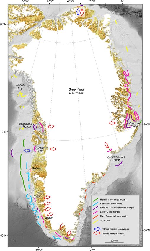
588                                                          S. Funder et al.: Younger Dryas ice margin retreat in Greenland

of deglaciation of the shelf when a contiguous GrIS margin        shelf (van Tatenhove et al., 1996; Roberts et al., 2009). In
transformed into outlet glaciers in transverse troughs feed-      our area a limited YD readvance on the inner shelf, the Ne-
ing the shelf (Fig. 1). Despite field observations that coastal   ria stade, was postulated by Weidick et al. (2004) based on
islands experienced warm-based glacial scouring, 10 Be in-        weathering limits on coastal mountains. A YD readvance in
heritance from episodes of earlier exposure influences some       this part of the GrIS was also suggested by modelling, which
samples in our chronology. Still, clustered ages suggest that     indicated that the ice margin in SW Greenland retreated from
the GrIS margin generally retreated during the middle YD.         the shelf edge to the present coastline in the Bølling–Allerød
These results are discussed in the context of previous studies    period but then returned to the shelf during YD (Simpson et
elsewhere in Greenland, indicating a mismatch between tem-        al., 2009; Lecavalier et al., 2014). A grounding zone wedge
perature records and ice margin behaviour. Possible mecha-        in the Fiskenæsset trough points to a stillstand or readvance
nisms which may overrule or mute the effect of temperature        of the glacier front at an unknown time during deglaciation
change in this environment are discussed.                         (Fig. 1; Ryan et al., 2016). The significance of these features
                                                                  is discussed below in light of our new chronology.
2     Background
                                                                  3   Field and laboratory methods
2.1    Setting

The continental shelf in the study area in southwestern           Samples were collected from the summits of bedrock knobs
Greenland narrows from a width of ca. 70 km in the north          in glacially sculpted islands along the inner shelf in south-
to ca. 50 km in the south (Fig. 1). It is composed of an          western Greenland. Unfortunately, erratic boulders on the
inner ca. 25 km wide and up to 500 m deep trough run-             bare rock surfaces were largely absent. This potentially rep-
ning along the coast that is dissected by glacial erosion         resents a problem because while boulders were ideally in-
in Proterozoic orthogneiss bedrock (Henriksen, 2008). On          corporated into the ice in a pristine condition without previ-
the outer shelf, a belt of shallow banks with a gently un-        ous exposure to cosmic radiation, the glacial erosion of the
dulating surface is composed of younger stratified marine         bedrock surface may not have been deep enough to remove
and fluvial sediments. These banks are dissected by 400 to        inherited isotopes from older exposures, which may result in
500 m deep transverse troughs that are a continuation of the      overestimation of the age (Briner et al., 2006; Corbett et al.,
major fjords inland (Holtedahl, 1970; Sommerhoff, 1975;           2013; Larsen et al., 2014). To minimize the risk of inheri-
Roksandic, 1979; Sommerhoff, 1981; Ryan et al., 2016). At         tance, we selected sites in the lowland, where the overlying
a distance of 10–15 km beyond the coast, the inner trough         ice would have been thickest and most erosive, but above the
forms an archipelago, with a multitude of small glacially         marine limit to avoid the risk of shielding of the rock surface
sculptured rocky islands and skerries reflecting intensive but    by the sea. From each site we collected three to four samples
uneven glacial erosion. From these rocky islands we col-          within a small radius to be sure that all samples from each
lected our samples (Fig. 2).                                      locality had been deglaciated at the same time.
                                                                     Contrary to inheritance, other geologic processes may
2.2    Deglaciation history
                                                                  yield ages that are younger than the true time of exposure.
                                                                  This may occur if a surface has been partially shielded from
Although there is little evidence for glacier overriding, it is   cosmic radiation by vegetation, snow cover or a veneer of
likely that the ice sheet covered the rather narrow shelf dur-    glacial sediments for some time (Gosse and Phillips, 2001).
ing the LGM (Last Glacial Maximum, ca. 22 ka); evidence           However, it is unlikely that the rocky summits were vege-
from a marine core in the Davis Strait outside the Fiskenæs-      tated, as soil would have been washed into the depressions of
set trough suggests that the ice margin here stood at the         the glacial sculpture, which was not observed (Fig. 2). Also,
shelf break until deglaciation began at ca. 18.6 cal ka (Win-     long-lasting and deep snow cover over sample sites is un-
sor et al., 2015a). By ca. 11 ka, the retreating ice margin       likely in the stormy and maritime climate at the outer coast.
reached the present coastline, and the subsequent deglacia-       Indeed, we experienced heavy snowfall during the sampling,
tion of the fjords and land began, as summarized by Winsor        with thick snow accumulating in hollows, while the tops
et al. (2015b). This leaves a period of ca. 7000 years with       were left free of snow (Fig. 2). Topographic shielding from
the ice margin inland of the shelf edge but otherwise unac-       nearby mountains was checked with a clinometer in the field.
counted for. Possible evidence for a prolonged GrIS margin           The laboratory work comprised sample preparation at the
during this interval includes a series of lobate moraines that    University of Buffalo and measurement of 10 Be concentra-
run along the troughs and impinge on the inner side of the        tions at the accelerator mass spectroscopy (AMS) facility at
banks (Fig. 1) (Sommerhoff, 1975; Winsor et al., 2015a).          Aarhus University. The laboratory procedure for the prepara-
From their setting, these moraines were correlated with the       tion followed the University at Buffalo’s protocols (Briner,
Fiskebanke moraine system to the north (Funder et al., 2011),     2015). Samples were crushed and sieved to 250–500 µm,
where they were thought to date from a YD readvance on the        then exposed to a magnetic separator to remove the more

Clim. Past, 17, 587–601, 2021                                                         https://doi.org/10.5194/cp-17-587-2021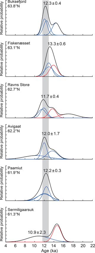
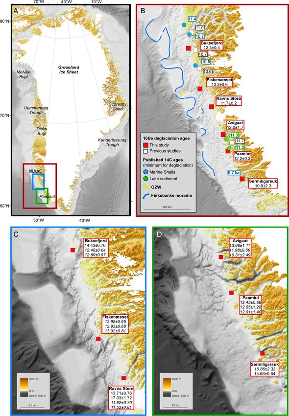
S. Funder et al.: Younger Dryas ice margin retreat in Greenland                                                                        589

Figure 1. Location of the study area (a). Estimated deglaciation ages and 14 C minimum constraints from this work and previous studies (b).
Details of the cosmogenic dates from this work and shelf bathymetry (c, d). For references to previous results, see the text. The background
map of Greenland and surrounding seas is from BedMachine Greenland v.3 (Morlighem et al., 2017).

magnetic minerals and facilitate the subsequent froth flota-            quartz from remaining minerals. Quartz purity was then ver-
tion. In addition to flotation, some samples (X1509, X1513,             ified by inductively coupled plasma optical emission spec-
X1521) had to undergo heavy-mineral separation to obtain                troscopy at the University of Colorado. Pure quartz sam-
sufficient amounts of quartz. Before the next step the sam-             ples were fully dissolved with a 9 Be carrier, and Be(OH)2
ples were examined under a microscope to see if they had                was isolated through column separation. The 10 Be/9 Be ratios
been substantially purified. Finally, the samples were etched           were measured at the Aarhus AMS Centre (AARAMS), and
by hydrogen chloride (HCl) and a mixture of hydrofluoric                all samples were blank-corrected (Olsen et al., 2016). Nu-
and nitric acid (HF/NHO3 ) in order to further isolate pure

https://doi.org/10.5194/cp-17-587-2021                                                                  Clim. Past, 17, 587–601, 2021
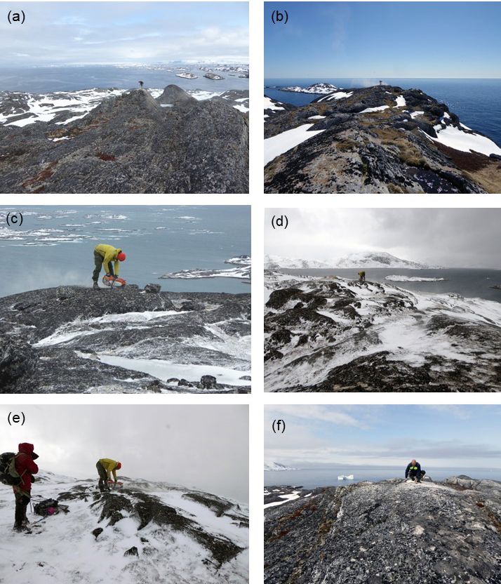
590                                                             S. Funder et al.: Younger Dryas ice margin retreat in Greenland

Figure 2. Sampling localities: (a) Buksefjord (sample X1526, 12.0 ka), (b) Fiskenæsset (sample X1521, 13.0 ka), (c) Ravns Storø (sample
X1520, 17.0 ka, inheritance), (d) Avigaat (sample X1518, 10.3 ka), (e) Pamiut (sample X1515, 12.0 ka), (f) Sermiligarssuk (sample X1507,
10.9 ka).

clide concentrations were normalized to the beryllium stan-           relative chronology. We used a rock density of 2.65 g cm3
dard 07KNSTD (Nishiizumi et al., 2007).                               and made no correction for potential surface erosion or
   The ages were calculated with the CRONUS-Earth on-                 snow and/or vegetation cover. The study area has undergone
line calculator (Balco et al., 2008), using the 10 Be/9 Be ratio      glacio-isostatic uplift since the deglaciation, and this may po-
measured by the AMS subtracted from the processed blank               tentially influence the 10 Be ages. However, as the production
ratio. The processed blank ratio was 2.10 × 10⁻¹⁵ , and the           rate calibration dataset probably experienced a similar uplift
blank-corrected sample ratios ranged from 0.76 × 10⁻¹³ to             history at our sample sites, no correction for glacio-isostatic
2.58 × 10⁻¹³ . The Arctic 10 Be production rate (Young et al.,        uplift is applied (see Young et al., 2020). Accordingly, we
2013) and the time-invariant scaling scheme for spallation            present 10 Be ages without correcting for glacio-isostatic up-
processes (given by Lal, 1991, and Stone, 2000) were ap-              lift, similar to most other 10 Be studies from Greenland. Indi-
plied. The time-invariant scaling scheme does not incorpo-            vidual 10 Be ages are presented with their 1σ analytical un-
rate variations in past geomagnetic field strength, but these         certainties, which include the uncertainty in the blank cor-
usually only affect younger samples at ca. 10 ka by 1 %               rection; this is the “internal” uncertainty (Table 1). When we
(Nishiizumi et al., 2007). The maximum deviation between              compare our 10 Be ages with 14 C ages or climate records we
different scaling schemes in this material is ca. 1 %, so             include the production rate uncertainty, which is the “exter-
they generally provide consistent ages and do not affect the          nal” uncertainty (Balco et al., 2008).

Clim. Past, 17, 587–601, 2021                                                              https://doi.org/10.5194/cp-17-587-2021
S. Funder et al.: Younger Dryas ice margin retreat in Greenland                                                                                                                            591

Table 1. Summary of 10 Be data from southwestern Greenland.

    Sample       Latitude    Longitude       Elevation Sample          Shielding Thickness Quartz           9 Be carrier       10 Be con.           10 Be uncert.      10 Be age (ka) internal
    ID             (N)         (W)           (m a.s.l.) type1          factor    (cm)       (g)             weight (g)     (atoms per g)×104     (atoms per g)×104   (external) uncertainties2
    Buksefjord
    X1524      63.83957       51.73826       118          bedrock      1           4.5           40.45        0.6067             6.88                   0.36             14.43 ± 0.76 (1.03)
    X1525      63.83970       51.73851       117          bedrock      1           5.5           33.19        0.6082             5.90                   0.30             12.48 ± 0.64 (0.88)
    X1526      63.83967       51.73839       102          bedrock      1           6             40.13        0.6086             5.59                   0.26             12.06 ± 0.57 (0.82)
                                                                                                  Calculated average (number of samples out of total)                   12.3 ± 0.4 (n = 2/3)
    Fiskenæsset
    X1521      63.04961       50.99505       76           bedrock      0.99996     4.5           21.16        0.6068             5.93                   0.43             12.98 ± 0.95 (1.14)
    X1522      63.05008       50.99449       75           bedrock      0.99997     5.5           26.75        0.6074             5.85                   0.31             12.93 ± 0.68 (0.93)
    X1523      63.05016       50.99454       76           bedrock      0.99997     5.5           36.35        0.6049             6.31                   0.36             13.92 ± 0.81 (1.05)
                                                                                                  Calculated average (number of samples out of total)                   13.3 ± 0.6 (n = 3/3)
    Ravns Storø
    X1519      62.71573       50.40947       193          bedrock      0.99999     7             35.09        0.6074             6.95                   0.38             13.71 ± 0.76 (1.01)
    X1520      62.71573       50.40947       189          bedrock      0.99999     6             45.21        0.6083             8.66                   0.87             17.03 ± 1.72 (1.91)
    X9364      62.71799       50.41719       209          bedrock      1           4.5           34.47        0.6092             6.26                   0.37             11.91 ± 0.70 (0.91)
    X9365      62.71770       50.41629       208          boulder      1           4.5           39.87        0.613              6.05                   0.43             11.52 ± 0.81 (0.99)
                                                                                                  Calculated average (number of samples out of total)                   11.7 ± 0.4 (n = 2/4)
    Avigaat
    X1516      62.17882       49.80153       47           bedrock      1           7             45.06        0.6062             5.94                   0.48             13.68 ± 1.11 (1.29)
    X1517      62.17888       49.80107       44           bedrock      1           6             45.08        0.6089             5.23                   0.24             11.98 ± 0.56 (0.81)
    X1518      62.17894       49.80064       42           bedrock      1           4.5           45.26        0.608              4.55                   1.10             10.31 ± 2.49 (2.54)
                                                                                                  Calculated average (number of samples out of total)                   12.0 ± 1.7 (n = 3/3)
    Paamiut
    X1513      61.85744       49.53121       65           bedrock      1           6             32.31        0.6111             5.57                   0.29             12.45 ± 0.66 (0.89)
    X1514      61.85734       49.53098       61           bedrock      1           6.5           25.48        0.6086             5.34                   0.56             12.05 ± 1.28 (1.40)
    X1515      61.85708       49.53045       60           bedrock      1           5.5           35.44        0.607              5.36                   0.62             12.01 ± 1.40 (1.52)
                                                                                                  Calculated average (number of samples out of total)                   12.2 ± 0.3 (n = 3/3)
    Sermiligarsuk
    X1507      61.32122       48.86104       57           boulder      0.99967     6             33.35        0.6086             4.81                   1.02             10.86 ± 2.32 (2.38)
    X1509      61.32136       48.86013       61           bedrock      0.9997      5.5           24.76        0.5672             6.55                   0.37             14.66 ± 0.84 (1.10)
                                                                                                            Best estimate for deglaciation age                          10.9 ± 2.3 (n = 1/1)
1 All samples are coarse-grained orthogneiss. 2 Italics: used in the average or best estimate (see text).

   Previously published 14 C ages have been recalibrated us-                                                of deglaciation or thinning of ice streams at fjord mouths.
ing the Intcal20 calibration programme (Reimer et al., 2013).                                               In addition, we also show 14 C results on dating marine mol-
Following the procedure adopted for dates on marine shells                                                  luscs or the onset of organic sedimentation in coastal lakes.
from Greenland, ages on marine shells have been corrected                                                   Although not dating deglaciation, these dates serve as min-
with a 1R of 0 for western Greenland and with a 1R of                                                       imum constraints for local deglaciation. Much of this infor-
−150 years for eastern Greenland based on dating modern                                                     mation has recently been reviewed by Sinclair et al. (2016).
pre-bomb shells (e.g. Mörner and Funder, 1990), acknowl-                                                    The six sites are described below, and the results are shown
edging that significant, but unknown, changes in the reservoir                                              in Table 1 and Fig. 3.
effect may potentially have affected the ages, especially in
the turbulent millennia during the early deglaciation phases
(e.g. Andrews et al., 2018).
                                                                                                            4.1     Buksefjord

4     Results and interpretations                                                                           This site is located at the outer margin of the strandflat,
                                                                                                            ca. 15 km from the main coastline and midway between the
As discussed below, we consider a spread of old ages to be                                                  mouth of Ameralikfjorden and Buksefjorden (Fig. 1). The
“inheritance outliers”, while the mean of clustered younger                                                 three bedrock samples from this locality were collected be-
ages gives the most reliable deglaciation age. Where there is                                               tween 102 and 118 m a.s.l. and yielded ages of 14.4 ± 0.8 ka
no overlap between the uncertainties, we regard the youngest                                                (X1524), 12.5 ± 0.6 ka (X1525) and 12.1 ± 0.6 ka (X1526).
age as a maximum age for deglaciation. At each site our new                                                 We interpret the oldest age as an outlier. The two youngest
ages are compared to previously published cosmogenic dates                                                  ages have overlapping internal uncertainty and average

https://doi.org/10.5194/cp-17-587-2021                                                                                                              Clim. Past, 17, 587–601, 2021
592 S. Funder et al.: Younger Dryas ice margin retreat in Greenland
12.3 ± 0.4 ka, which we interpret as the time of deglaciation
at this site.
On the coastal mountains ca. 10 km to the east, 10 Be dates
of boulders from between 82 and 360 m a.s.l. gave an average
deglaciation age of 10.7 ± 0.6 ka (Larsen et al., 2014). At the
mouth of the Nuuk Fjord Complex, 30 km to the north, ma-
rine shells on the outer coast gave a minimum constraint for
the deglaciation of 11.4 cal ka (Weidick, 1976a), while 10 Be
ages close to Nuuk showed deglaciation at ca. 11 ka (Win-
sor et al., 2015b). This may imply that our dates here are
some centuries too old, although the dates from around Nuuk
Fjord indicate that the outer coast became ice-free while an
ice stream still occupied the Nuuk trough.
4.2 Fiskenæsset
Three bedrock samples were collected in the outer
archipelago ca. 6 km from the coast on a small ice-scoured
island ca. 15 km west of the Fiskenæsset settlement (Fig. 1).
The samples were collected from 75–76 m a.s.l and yielded
ages of 13.0 ± 1.0 ka (X1521), 12.9 ± 0.7 ka (X1522) and
13.9 ± 0.8 ka (X1523). The average, 13.3 ± 0.6 ka, is the old-
est deglaciation date of our sites (Fig. 1).
These ages imply that the GrIS margin here was close to
the coast prior to the YD. This result should be substantiated
by other sources, but there is no available evidence from the
adjacent coast to support or oppose this timing of deglacia-
tion. Farther north, at Sermilik Fjord, 14 C dates of marine
molluscs show that the initial marine transgression and re-
treat of the GrIS from the outer coast probably did not begin
until a short time before 10.5 cal ka, and on coastal moun-
tains nearby, 10 Be ages from 450 m a.s.l. show that the GrIS
surface had thinned at ca. 10.6 ka (Larsen et al. 2014). Even
though these results come from a different trough, the differ-
ence in dates for deglaciation of the coast of 2000 years war-
rants confirmation (it should be noted that Weidick, 1976b,
considered the Sermilik glacier to be the last to retreat from
the shelf in this part of Greenland, while the areas to the north
and south had already been ice-free for several millennia).
4.3 Ravns Storø
Four samples were collected on the island of Ravns
Storø, in the middle of the archipelago, ca. 5 km from
the coast (Fig. 1). The samples were collected between
189 and 209 m a.s.l. within a radius of 200 m. The ages
show a spread of more than 5000 years: 13.7 ± 0.8 ka
(X1519), 17.0 ± 1.7 ka (X1520), 11.9 ± 0.7 ka (X9364) and
Figure 3. Normal kernel density plots for the 10 Be ages from six 11.5 ± 0.8 ka (X9365). The two youngest ages, including
coastal sites in SW Greenland. The mean age (black) is calculated our only boulder sample (sample X9365), have overlap-
based on the individual samples (blue) after excluding statistical ping internal uncertainties, and we consider their average,
outliers (red) (see Table 1). 11.7 ± 0.4 ka, to be the best estimate for the time of deglacia-
tion at this site, while the oldest ages are outliers. From this
area there is no supporting information on deglaciation his-
tory.
Clim. Past, 17, 587–601, 2021 https://doi.org/10.5194/cp-17-587-2021S. Funder et al.: Younger Dryas ice margin retreat in Greenland 593
4.4 Avigaat age is the youngest for deglaciation of the inner shelf, but the
island is also closer to the coast than any of the other sites.
Three samples from the bedrock surface were collected
Marine shells below the marine limit in the nearby outer
from an islet in the inner archipelago, ca. 3 km from the
Sermiligaarsuk Fjord have an 14 C age of 9.7 cal ka, providing
coast and the abandoned Avigaat settlement (Fig. 1). The
a minimum for deglaciation at this site (Weidick et al., 2004).
samples were taken between 42 and 47 m a.s.l. and yield
ages of 13.7 ± 1.1 ka (X1516), 12.0 ± 0.5 ka (X1517) and
10.3 ± 2.5 ka (X1518). The variable ages and their uncertain- 5 Discussion
ties are large. Because these ages overlap, we consider the
average of 12.0 ± 1.7 ka to be the best estimate for deglacia- 5.1 Overview of results from southwestern Greenland
tion at this site. Some support for the idea that this might
According to the criteria outlined above, two of the
be generally correct comes from a 14 C age of ca. 11.3 cal ka
sites, Paamiut (12.2 ± 0.2 ka; n = 3) and Fiskenæsset
from basal gyttja in a lake in coastal Nerutussoq Fjord to the
(13.3 ± 0.6 ka; n = 3), contain no obvious outliers and hence
south (Fig. 1), providing a minimum age for deglaciation at
no obvious inheritance, implying deglaciation ages during
this site (Kelly and Funder, 1974).
the middle YD (Paamiut) and prior to the YD (Fiskenæs-
set). Also, Avigaat has overlapping uncertainties, indicating
4.5 Paamiut deglaciation in late YD times but with large uncertainty. At
This site is located on a small ice-scoured island on the inner two sites, Buksefjord and Ravns Storø, one or two samples
archipelago, ca. 5 km from the coast and close to the mouth are interpreted as being influenced by inheritance, but the
of Kuanersoq Fjord and the town of Paamiut (Fig. 1). Here, remaining clusters indicate deglaciation during the middle
three bedrock samples between 60 and 65 m a.s.l. are dated to late YD. Finally, at Sermiligarssuk only one sample is
to 12.5 ± 0.7 X1513), 12.1 ± 1.3 (X1514) and 12.0 ± 1.4 ka considered free of inheritance, yielding a best estimate for
(X1515). All three ages overlap within the internal uncer- deglaciation in the early Holocene. From this, the results, al-
tainty and average 12.2 ± 0.3 ka. though affected by inheritance, would point to deglaciation
Around Paamiut and Kuanersoq several studies have sup- on the inner shelf in this part of Greenland at varying times
plied both 10 Be and 14 C deglaciation dates for the outer fjord. between the late Allerød and the early Holocene. However,
As expected, these deglaciation dates from farther inland at some sites the ages are significantly older than expected
are somewhat younger than ours. 10 Be dates from Kuaner- from a comparison with previous dating of deglaciation at
soq indicate thinning of the ice margin in the fjord begin- the adjacent coast.
ning ca. 11.7 ka and, by extrapolation, retreat from the fjord At Paamiut, Fiskenæsset and Buksefjord, our ages are
mouth at ca.11.2 ka (Winsor et al., 2015b). From a 14 C age up to 2000 years older than deglaciation ages obtained at
of 11.0 cal ka for basal gyttja in a lake 8 km from our sam- nearby fjord mouths. A possible explanation may be that
ples and well below the local marine limit, Woodroffe et while the coastal areas became ice-free, ice lingered in the
al. (2014) suggested that deglaciation could not have been major troughs, not reaching the inner shelf until the early
much earlier than ca. 11 ka. These results from nearby coastal Holocene, as shown previously for ice streams in Disko Bugt
localities therefore indicate deglaciation ca. 1000 years later (Jennings et al., 2014) and suggested by Weidick (1976b) for
than at our site. Much of this work concerned the ice stream our area in southwestern Greenland.
in Kuanersoq, while our samples come from the open coast However, the offset in deglaciation ages, especially the
to the south, and we suggest that an ice stream in the Kuan- oldest from Fiskenæsset, could also be impacted by a small
ersoq trough remained at the inner shelf while the adjacent amount of uniform inheritance in the bedrock, as demon-
coastal areas became ice-free. strated at Utsira, Norway (Briner et al., 2016). Uniform in-
heritance may influence the mean age from a cluster, mean-
ing that several bedrock samples from adjacent sites could all
4.6 Sermiligaarsuk
have experienced a similar amount of inheritance. This ef-
From a small island in the inner archipelago, ca. 2 km from fect is considered to particularly affect bedrock and boulders
the coast and 12 km south of the Sermiligaarsuk Fjord, we in areas that experienced long ice-free periods between brief
collected two samples from 56 and 61 m a.s.l. One sample is maximum glacial phases (Briner et al., 2016). The landscape
from bedrock (X1509) and one is from a 1 m diameter boul- in the coastal archipelago is the result of intense erosion by
der (X1507). The two samples have widely scattered ages warm-based ice, probably back through several glaciations
of 10.9 ± 2.3 ka (X1507, boulder) and 14.7 ± 0.8 ka (X1509, and during the better part of the last ice age (e.g. Nielsen and
bedrock) with large uncertainty, particularly in the boulder Kuijpers, 2013; Seidenkrantz et al., 2019), and we consider
age. The oldest age is unrealistic for deglaciation and in- the type of deep, uniform inheritance as described by Briner
terpreted as an inheritance outlier. The age of 10.9 ± 2.3 ka et al. (2016) to be unlikely in our samples.
(sample X1507), one of our few boulder dates, is interpreted A possibly more likely type of uniform inheritance could
as a closer approximation for deglaciation at this site. This be if the ice margin readvanced but failed to erode the
https://doi.org/10.5194/cp-17-587-2021 Clim. Past, 17, 587–601, 2021594 S. Funder et al.: Younger Dryas ice margin retreat in Greenland
bedrock deeply enough to remove the 10 Be signal from pre- al., 2012) and, as noted by O’Cofaigh et al. (2013), seems
vious exposure. This could have happened during a YD read- irreconcilable with YD temperatures. As a possible expla-
vance, as suggested for this area by Weidick et al. (2004) and nation O’Cofaigh et al. (2013) tentatively suggested that the
Lecavalier et al. (2014). However, independent dating is re- advance was a glacio-dynamic surge-like event, when a thin
quired to show if any of these potential errors have affected and mobile ice stream confined in the trough advanced to the
the ages, especially those from Fiskenæsset. shelf edge. Whatever the explanation, this singular event is
In summary, the 10 Be dates from the coast of southwestern without parallel anywhere in Greenland and is hardly signif-
Greenland, although affected by inheritance, suggest that the icant for YD climate change.
ice sheet margin retreated on the inner shelf close to the coast On the east side of Greenland, in Kangerlussuaq trough
at least from middle to late YD times. Some dates are very and fjord (Fig. 4), not only the shelf, but also most of the
old compared to deglaciation dates on the coast. This could fjord became ice-free during YD (e.g. Andrews et al., 2018).
be due to differential ice margin behaviour in and away from It is noteworthy that in these areas, as well as other areas
troughs or, in the case of the oldest age, to ice margin read- with a record going back to the Allerød (Scoresby Sund,
vance over ice-free land. southernmost Greenland), there is no evidence for marked
ice margin response to the initial YD cooling. In these two
5.2 YD ice margins in Greenland
areas, the GrIS had retreated behind the present coastline be-
fore YD (e.g. Björck et al., 2002; Larsen et al., 2016; Levy
From a recent review of YD ice margins in Greenland, et al., 2016; Levy et al., 2020). Only on the north coast of
Larsen et al. (2016) concluded that ice margin retreat in- Greenland did glaciers apparently advance and retreat at the
deed characterized most areas with a dated record going back beginning and end of the YD (Larsen et al., 2016).
through or at least into the YD. This is well constrained by In areas where the dated record goes back only to the mid-
10 Be dating in coastal areas and 14 C-dated marine sediment dle YD, such as most of our area, or areas where the ice re-
cores in and outside major cross-shelf troughs, and it ap- mained on the shelf until early Preboreal times, as shown
plies to areas in western, eastern and southernmost Green- by recent cosmogenic dates from coastal southeastern Green-
land (Fig. 4). More recently, GrIS retreat during the YD has land and the Sisimiut area (Fig. 4) (Dyke et al., 2018; Rains-
been corroborated from the Disko Bugt shelf (Hogan et al., ley et al., 2018; Levy et al., 2020; Young et al., 2020), the ice
2016; Oksman et al., 2017) and from eastern and southern margin retreat may be seen as a response to the slow warm-
Greenland (Levy et al., 2016; Andrews et al., 2018; Dyke et ing in the latter portion of the YD (Vacco et al., 2009; Buizert
al., 2018; Rainsley et al., 2018). et al., 2018). Therefore, while the dated records going back
In available records, the most dramatic and studied retreat to Allerød times do not show evidence of ice margin read-
occurred on the shelf at Disko Bugt, where the ice stream ap- vance or stillstand at the initial YD cooling, a readvance may
parently retreated over more than 200 km from an Allerød– have occurred in other areas, considering the large variation
early YD position near the shelf break (Fig. 4), but the re- in YD ice margin behaviour seen in the dated records. Below
treat was punctuated by periods of topographically condi- we discuss evidence (e.g. landforms on the shelf) which has
tioned stillstand and a spectacular, but brief, readvance (e.g. been attributed to such a YD ice margin readvance or still-
O’Cofaigh et al., 2013; Hogan et al., 2016). This is the only stand.
readvance dated to the YD in western Greenland and de-
serves a closer look. The readvance and retreat are recorded 5.3 YD readvance on the shelf? Moraines and GZWs
by till on the outer shelf and debris flows at the shelf edge.
Surprisingly, 14 C dates on reworked shell fragments below, Since their first discovery, the Hellefisk and Fiskebanke
within and above the till, as well as in debris flows at the moraines on the western Greenland shelf have played a
shelf edge, all give overlapping ages. Moreover, mid-shelf in prominent role in the discussion of early deglaciation his-
situ shells, which postdate the retreat, also give an overlap- tory (Fig. 4) (e.g. Kelly, 1985; Funder et al., 2011; Hogan et
ping age. This shows that both advance and retreat took place al., 2016). The outermost and oldest, the Hellefisk moraine
over a very short period. Using the median ages as an indi- system, runs along the shelf break for 200 km at a depth of
cation, Hogan et al. (2016) suggested that retreat from the ca. 200 m, ca. 120 km from the coast, and consists of swarms
shelf edge began at ca. 12.24 cal ka and proceeded until ca. of up to 100 m high ridges (Brett and Zarudski, 1979). To the
12.1 cal ka, when the ice margin stabilized in late YD times, east of this, halfway towards the coast, the younger Fiske-
and was pinned on mid-shelf topography ca. 150 km from banke moraines impinge on the inner side of the fishing
the shelf edge. This would imply an average retreat rate of banks ca. 40 km from the coast. These are composed of sin-
ca. 1 km yr−1 , including decade-long stops at several GZWs gle ridges, which occur intermittently on the inner banks and
(grounding zone wedges; see below) on the way. Even con- along the sides of transverse troughs for a distance of ca.
sidering the large uncertainties in the dates, the retreat rate 500 km along the coast (Fig. 4). Although undated, the two
would be comparable to the highest retreat rates recorded for moraine systems have generally been regarded as climate sig-
tidewater glaciers in SE Greenland in recent times (Bjørk et nals for two distinct periods of cooling – either Saalian and
Clim. Past, 17, 587–601, 2021 https://doi.org/10.5194/cp-17-587-2021S. Funder et al.: Younger Dryas ice margin retreat in Greenland 595 Figure 4. Deglacial ice margin features in Greenland discussed in the text. Question marks at grounding zone wedges apply to age and come from the original literature. Sources are Larsen et al. (2016) and the references discussed in the text. The background map of Greenland and surrounding seas is from BedMachine Greenland v.3 (Morlighem et al., 2017). https://doi.org/10.5194/cp-17-587-2021 Clim. Past, 17, 587–601, 2021
596                                                            S. Funder et al.: Younger Dryas ice margin retreat in Greenland

LGM (Funder et al., 2011) or LGM and YD (van Tatenhove              times on the outer shelf, 150 km further away from the coast
et al., 1996; Roberts et al., 2009; Simpson et al., 2009; Lecav-    (Fig. 4). This was based on extrapolation from a 14 C age and
alier et al., 2014).                                                correlation with the ice core temperature record.
   Recently, for the first time, absolute ages have been sup-          An even larger discrepancy between the two dating ap-
plied for parts of the Hellefisk moraines, where Hogan et           proaches is seen in northeastern and eastern Greenland,
al. (2016), from 14 C dates in marine cores, found that in          where Arndt et al. (2017) and Arndt (2018) used multibeam
their study area south of Disko Bugt, these moraines rep-           bathymetry to interpret lineaments, mid-shelf GZWs and a
resent a topographically controlled calving bay dated to ca.        moraine at the mouth of Scoresby Sund as evidence for read-
12.2 cal ka. In contrast to this, from a marine core at the shelf   vance of fast-flowing ice streams in major troughs along the
edge off Nuuk, Seidenkrantz et al. (2019) found that the outer      northern east coast of Greenland (Fig. 4). These features
Hellefisk moraine dates to ca. 60 ka. These results imply that      were attributed to the YD by climatic inference. This over-
the outer Hellefisk moraines are not synchronous, but have          looks earlier work from land, especially in Scoresby Sund.
widely different ages, and are to some extent controlled not        Here Greenland’s highest concentration of 10 Be and 14 C
by climate but by topography.                                       dates shows that the outlet glaciers in this fjord system had
   Extending for 500 km along the coast the younger Fiske-          retreated into the fjord during the Allerød, forming a swarm
banke moraines would be the most compelling evidence for            of moraines dating from the Allerød through the YD and into
ice margin response to YD cooling in Greenland if they              the Preboreal (Denton et al., 2005; Kelly et al., 2008; Hall et
can be dated to YD. The results from Hellefisk moraines             al., 2010; Vasskog et al., 2015; Levy et al., 2016), ruling out
may also cast some doubt on the climatic significance of            the possibility of a major YD readvance to or on the shelf,
the Fiskebanke moraines. Their affinity to the inner shelf             Similar outbursts of fast-flowing ice streams reaching mid-
trough and transverse troughs could indicate topographic,           shelf GZWs were also recorded farther north in transect
rather than climatic, control. As noted above our dates from        troughs at Kong Oscar Fjord, Kejser Franz Joseph Fjord
Fiskenæsset, well behind the moraines, could be interpreted         and the wide shelf of northeastern Greenland; these were
either in favour of or against a YD readvance to the moraines.      dated by the same means to the YD (Arndt et al., 2017;
This stresses the need for climate-independent dating of this       Arndt, 2018). It has also been overlooked here that mid-fjord
important event.                                                    moraines, 100 km behind the mid-shelf GZWs, have previ-
   Other geomorphic evidence for YD readvance or long-              ously been dated to the late YD–earliest Preboreal after cali-
lasting stillstand has recently been suggested from several         bration of the 14 C ages (Hjort, 1979). Reconciling these two
major transect troughs. This is based on high-resolution            datasets would imply an extraordinarily dynamic behaviour
multibeam bathymetry, revealing a large variety of glacial          of the ice margin along the eastern Greenland seaboard, with
landforms that formed during retreat of major ice streams.          both advances and retreats of more than 100 km within the
Notably, the occurrence of large GZWs has been suggested            YD in a period with increased sea ice along the coast (Flück-
to reflect long-lasting stillstand on the mid-shelf (see refer-     iger et al., 2008; Buizert et al., 2018).
ences below). GZWs are wedge-shaped sediment accumu-                   In northwestern Greenland, mid-shelf GZWs with a length
lations deposited at the front of an ice stream during a pe-        of more than 100 km have been recorded in transect troughs
riod of stability (e.g. Dowdeswell and Fugelli, 2012). GZWs         on the shelf in Melville Bugt (Slabon et al., 2016; Newton et
have now been observed in most investigated troughs around          al., 2017). From analogy with the “climate-correlated” Uum-
Greenland, and, although not dated, prominent GZWs have             mannaq GZW they were tentatively referred to the YD, al-
tentatively been assigned to the YD based on the assumption         though non-climatic bathymetric conditions may have also
that they correlate with cold periods in the ice core tempera-      determined their position (Newton et al., 2017).
ture record (Sheldon et al., 2016; Slabon et al., 2016; Arndt          In summary, some of the landforms on the shelf, which
et al., 2017; Newton et al., 2017; Arndt, 2018).                    on climatic grounds have been attributed to YD ice margin
   In the Uummannaq trough deglaciation of the shelf began          readvance or stillstand, apparently do not date from the YD,
before 15 ka, and by ca. 11.5 cal ka the large ice stream in the    and surprisingly, none of the 14 C- and 10 Be-dated records
trough had disintegrated into fjord glaciers with their front       show evidence for ice margin response to initial YD cool-
close to the present ice margin (e.g. Jennings et al., 2017).       ing (Fig. 4). This highlights the need for climate-independent
However, there are two very different views on what hap-            dating of the submarine landforms and GZWs to exploit this
pened in the intervening 3500 years. Based on exposure ages         rich source of information and get a better understanding of
on coastal mountains and 14 C dates in the fjords, Roberts et       the ice sheet–climate relation.
al. (2013) found that the large Uummannaq ice stream had
retreated from the trough and into the fjords during the YD,
controlled by topography and bathymetry (Fig. 4). In con-           5.4   Ice margin retreat during the YD cold oscillation?
trast, Sheldon et al. (2016), from a series of marine cores
and a prominent GZW in the transect trough, suggested that          To explain the mismatch between YD cooling and apparent
the ice stream was stabilized for 2000 years from Allerød           ice margin retreat, two agents have especially been called on:

Clim. Past, 17, 587–601, 2021                                                           https://doi.org/10.5194/cp-17-587-2021
S. Funder et al.: Younger Dryas ice margin retreat in Greenland                                                              597

advection of warm oceanic subsurface water to the ice mar-        2018). This results in very cold and arid winters and an in-
gin and increased climatic seasonality.                           crease in the extent and duration of sea ice, while summer
   In both cases the sequence of events begins with increased     temperatures – which primarily determine a glacier’s mass
production of meltwater around the North Atlantic during the      balance – are less affected and may even warm up (Björck et
Allerød warm period. The fresher and lighter water eventu-        al., 2002).
ally sealed off the Atlantic surface circulation from the at-        Vacco et al. (2009) presented a glaciological model for
mosphere and impeded the Atlantic Meridional Overturning          warm-based glaciers on land, tuned with a temperature
Circulation (AMOC). However, warm water from the sub-             record from a Greenland ice core, showing that for areas
tropical areas was still driven into the North Atlantic but as    with high-amplitude change between the Allerød and YD,
subsurface currents (Marcott et al., 2011; Ezat et al., 2014).    moraine deposition would be expected at the beginning of
The subsurface water followed the path of the present North       the YD, followed by recession of the ice margin in the mid-
Atlantic surface circulation in the Irminger Current run-         dle and late YD. This may explain why major YD moraines
ning south along southeastern Greenland, continuing around        in Greenland have been seen only in northernmost Green-
Greenland’s southern tip, and heading northwards as the           land and Scoresby Sund – two areas where the glaciers had
West Greenland Current (Fig. 1). Along the Greenland shelf        already become landlocked before the YD, while the ice mar-
the warm Atlantic subsurface water was present and caused         gin in most other areas retreated on the shelf, controlled to a
ice margin retreat in southeastern and western Greenland at       large extent by warm subsurface ocean circulation.
15–16 cal ka, and it was continuously present at the south-          The importance of changing seasonality has recently been
eastern Greenland shelf edge through Bølling–Allerød and          investigated in a model wherein the deglacial ice core tem-
YD times (Kuijpers et al., 2003; Knutz et al., 2011; Jennings     perature records in three ice cores are combined with simu-
et al., 2017; Andrews et al., 2018).                              lated seasonal air temperatures for the whole of Greenland,
   Today warm subsurface water from these currents, below         enabling assessment of variations in seasonality in time and
a cap of fresher water, causes extensive melting of floating      space (Buizert et al., 2018). The varied seasonality model
outlet glaciers in Greenland (e.g. Mayer et al., 2000; Motyka     deviates from previous models (e.g. Lecavalier et al., 2014),
et al., 2011), and during the early phase of deglaciation when    indicating that the dramatic temperature changes in the ice
the GrIS had its entire margin on the shelf it was especially     core records at the beginning and end of the YD are muted in
sensitive to the advection of warm subsurface water, causing      the varied seasonality model.
ice margin retreat even when temperatures were dropping, as          In summary, the apparent contradiction between ice core
discussed extensively in the literature (Kuijpers et al., 2003;   temperature records, wherein temperatures dropped dramat-
Jennings et al., 2006; Knutz et al., 2011; Rinterknecht et al.,   ically at the onset of the YD, and the dated glacial record
2014; Winsor et al., 2015b; Sheldon et al., 2016; Sinclair et     wherein glaciers in many parts retreated, may be explained
al., 2016; Jennings et al., 2017; Oksman et al., 2017; An-        by the effect of warm subsurface water on the ice margin,
drews et al., 2018; Dyke et al., 2018; Rainsley et al., 2018).    which was, all around Greenland, located on the shelf during
   Crucial to the impact of the warm water is the depth of        the early phase of deglaciation. Local topographic and bathy-
the grounding line at the ice margin and accessibility for        metric conditions controlled the access of warm water to the
the warm subsurface water. This is again dependent on local       ice margin when on the shelf. Increased seasonality was due
bathymetry and – in the troughs – on the type of connection       to an increase in the distribution and duration of winter sea
to the open ocean, which in each area may control the impact      ice, and the YD temperature drop in the ice cores was due to
of the warm water on the ice margin, as well as the impact        a large extent to lowering of winter temperatures with little
from changing sea level and the presence or absence of but-       impact on the ice margin but a large effect on the distribution,
tressing sea ice. This may explain why the deglaciation of the    thickness and duration of sea ice. This may also explain why
shelf and troughs had such a different character even between     neither the rapid initial YD cooling nor the abrupt warming
neighbouring troughs, such as between the rapid deglaciation      at the end left a clear signal in the dated records.
of the Kangerlussuaq trough and the much slower deglacia-
tion along the adjacent coast to the south (Dyke et al., 2018).
It may also explain the differences in the timing of the on-      6   Conclusions
set of deglaciation in the neighbouring Nuussuaq and Disko
troughs in western Greenland, as discussed by Jennings et         10 Be  dates on bedrock surfaces in the glacially eroded
al. (2017).                                                       archipelago on the inner shelf of southwestern Greenland are
   Increased seasonality is also connected to advection of        affected by 10 Be inherited from earlier exposure, but cluster-
meltwater over the North Atlantic and a reduced AMOC. The         ing of ages from each site suggest that the ice margin here
fresher meltwater-diluted water seals off the ocean surface       was retreating and close to the coast at least from mid-YD
and, especially in winter, cuts off the ocean–atmosphere ex-      times.
change (Denton et al., 2005; Hall et al., 2008; Vacco et al.,        A survey of 10 Be- and 14 C-dated records, going back
2009; Buizert et al., 2014; Levy et al., 2016; Buizert et al.,    through the YD elsewhere in Greenland to south, east and

https://doi.org/10.5194/cp-17-587-2021                                                          Clim. Past, 17, 587–601, 2021
598                                                                 S. Funder et al.: Younger Dryas ice margin retreat in Greenland

west, shows that the ice margin was also retreating but with             Acknowledgements. The fieldwork would not have been possi-
large differences in speed and extent even between neigh-                ble without generous support from the Danish Navy and the ship
bouring basins, probably controlled by local topography and              HDMS Knud Rasmussen, with its skipper and his extremely helpful
trough geometry.                                                         and joyful crew. We are grateful for the constructive and insightful
   While the retreat in our study and in other studies dates             comments offered by the referees David Ullman, David Roberts and
                                                                         Nicolas Adams, as well as discussion with Richard Alley.
from the middle or late YD and may be seen as retreat from
an initial YD readvance, areas with a record that goes back
into the Allerød show no evidence for ice margin readvance
                                                                         Financial support. This work is a part of the X_Centuries project
at the initial YD transition. Only in northernmost Greenland
                                                                         funded by the Danish Council for Independent Research (FNU)
did glaciers from a local ice cap apparently advance and re-             (grant no. DFF-0602-02526B) and the Centre for GeoGenetics sup-
treat at the beginning and end the of YD.                                ported by the Danish National Research Foundation (DNRF94).
   Moraines and GZWs on the shelf, which have been at-                   We also acknowledge support by the GeoCenter Denmark (“Multi-
tributed to YD readvance, are dated by climatic inference                millennial ice volume changes of the Greenland ice sheet”), all
and need direct age control to distinguish climatic from non-            granted to Kurt H. Kjær.
climatic factors.
   The apparent mismatch between the ice core temperature
record and the ice margin may be explained by the circum-                Review statement. This paper was edited by Alberto Reyes and
stance that during the LGM, the GrIS, contrary to other large            reviewed by David Roberts, David Ullman, and Nicolas Young.
ice sheets, around the whole perimeter was standing on the
shelf and especially sensitive to changes in ocean currents,
sea level, and sea ice distribution and thickness.
   Recently, high-resolution bathymetry has supplied a                   References
wealth of data on ice stream dynamics during deglacia-
tion. However, this evidence is essentially dated only by                Andrews, J. T., Cabedo-Sanz, P., Jennings, A. E., Olafsdottir, S.,
climate inference. To tap this rich source of information                  Belt, S. T., and Geirsdottir, A.: Sea ice, ice-rafting, and ocean
and get a better understanding of the ice sheet–climate re-                climate across Denmark Strait during rapid deglaciation (similar
                                                                           to 16–12 cal ka BP) of the Iceland and East Greenland shelves, J.
lation, climate-independent dating of the submarine features
                                                                           Quaternary Sci., 33, 112–130, 2018.
is badly needed.
                                                                         Arndt, J. E.: Marine geomorphological record of Ice Sheet devel-
   We subscribe to the contention by Andrews et al. (2018, p.              opment in East Greenland since the Last Glacial Maximum, J.
16): “The use of the GrIS’s isotopic records as a one-to-one               Quaternary Sci., 33, 853–864, 2018.
template for coeval changes in glacier and ocean response                Arndt, J. E., Jokat, W., and Dorschel, B.: The last glaciation and
potentially ignores the different response timescales between              deglaciation of the Northeast Greenland continental shelf re-
the atmosphere, oceans and cryosphere” – also with a bearing               vealed by hydro-acoustic data, Quaternary Sci. Rev., 160, 45–56,
on the future.                                                             2017.
                                                                         Balco, G., Stone, J. O., Lifton, N. A., and Dunai, T. J.: A complete
                                                                           and easily accessible means of calculating surface exposure ages
Code and data availability. The software used for determining              or erosion rates from 10 Be and 26 Al measurements, Quaternary
10 Be ages and recalibrating older 14 C ages is described in the text.     Geochronol., 3, 174–195, 2008.
All analytical information for the cosmogenic 10 Be measurements         Björck, S., Bennike, O., Rosen, P., Andresen, C. S., Bohncke, S.,
is listed in the table.                                                    Kaas, E., and Conley, D.: Anomalously mild Younger Dryas
                                                                           summer conditions in southern Greenland, Geology, 30, 427–
                                                                           430, 2002.
                                                                         Bjørk, A. A., Kjær, K. H., Korsgaard, N. J., Khan, A., Kjeldsen, K.
Author contributions. SF, KHK and AAB conceptualized the
                                                                           K., Andresen, C., Box, J. E., Larsen, N. K., and Funder, S.: An
project and carried out the work in the field. AHLS did the labo-
                                                                           aerial view of 80 years of climate-related glacier fluctuations in
ratory work, critical assessment and compilation of data under the
                                                                           southeast Greenland, Nat. Geosci., 5, 427–432, 2012.
supervision of and according to methodologies developed by JPB,
                                                                         Brett, C. P. and Zarudski, E. F. K.: Project Westmar, a shallow ma-
NKL, AS, LBL and JO. Visualization is thanks to NKL and AAB.
                                                                           rine geophysical survey on the West Greenland shelf, Geol. Surv.
The writing and editing were done by SF in close cooperation with
                                                                           Greenland, 87, 1–27, 1979.
NKL and AAB. KHK was responsible for the funding acquisition.
                                                                         Briner, J.: UB Quartz Cleaning Procedure, University at Buffalo,
                                                                           Buffalo, Ny, 20 pp., 2015.
                                                                         Briner, J. P., Goehring, B. M., Mangerud, J., and Svendsen, J. I.: The
Competing interests. The authors declare that they have no con-            deep accumulation of Be-10 at Utsira, southwestern Norway: Im-
flict of interest.                                                         plications for cosmogenic nuclide exposure dating in peripheral
                                                                           ice sheet landscapes, Geophys. Res. Lett., 43, 9121–9129, 2016.
                                                                         Briner, J. P., Miller, G. H., Davis, P. T., and Finkel, R. C.: Cos-
                                                                           mogenic radionuclides from fiord landscapes support differential

Clim. Past, 17, 587–601, 2021                                                                  https://doi.org/10.5194/cp-17-587-2021
S. Funder et al.: Younger Dryas ice margin retreat in Greenland 599 erosion by overriding ice sheets, Geol. Soc. Am. Bull., 118, 406– Holtedahl, O.: On Morphology of West Greenland Shelf with Gen- 420, 2006. eral Remarks on Marginal-Channel Problem, Mar. Geol., 8, 155– Buizert, C., Gkinis, V., Severinghaus, J. P., He, F., Lecavalier, B. 172, 1970. S., Kindler, P., Leuenberger, M., Carlson, A. E., Vinther, B., Jennings, A. E., Andrews, J. T., Cofaigh, C. O., St Onge, G., Shel- Masson-Delmotte, V., White, J. W. C., Liu, Z. Y., Otto-Bliesner, don, C., Belt, S. T., Cabedo-Sanz, P., and Hillaire-Marcel, C.: B., and Brook, E. J.: Greenland temperature response to climate Ocean forcing of Ice Sheet retreat in central west Greenland from forcing during the last deglaciation, Science, 345, 1177–1180, LGM to the early Holocene, Earth Planet. Sc. Lett., 472, 1–13, 2014. 2017. Buizert, C., Keisling, B. A., Box, J. E., He, F., Carlson, A. E., Sin- Jennings, A. E., Hald, M., Smith, M., and Andrews, J. T.: Fresh- clair, G., and DeConto, R. M.: Greenland-Wide Seasonal Tem- water forcing from the Greenland Ice Sheet during the Younger peratures During the Last Deglaciation, Geophys. Res. Lett., 45, Dryas: evidence from southeastern Greenland shelf cores, Qua- 1905–1914, https://doi.org/10.1002/2017GL075601, 2018. ternary Sci. Rev., 25, 282–298, 2006. Carlson, A. E.: The Younger Dryas Climate Event, Enc. Quaternary Jennings, A. E., Walton, M. E., Cofaigh, C. O., Kilfeather, A., An- Sci., 3, 126–134, 2013. drews, J. T., Ortiz, J. D., De Vernal, A., and Dowdeswell, J. Corbett, L. B., Bierman, P. R., Graly, J. A., Neumann, T. A., and A.: Paleoenvironments during Younger Dryas-Early Holocene Rood, D. H.: Constraining landscape history and glacial erosiv- retreat of the Greenland Ice Sheet from outer Disko Trough, cen- ity using paired cosmogenic nuclides in Upernavik, northwest tral west Greenland, J. Quaternary Sci., 29, 27–40, 2014. Greenland, Geol. Soc. Am. Bull., 125, 1539–1553, 2013. Kelly, M.: A review of the Quaternary geology of western Green- Denton, G. H., Alley, R. B., Comer, G. C., and Broecker, W. S.: land, in: Quaternary environments eastern Canadian Arctic, Baf- The role of seasonality in abrupt climate change, Quaternary Sci. fin Bay and western Greenland, edited by: Andrews, J. T., Allen Rev., 24, 1159–1182, 2005. & Unwin, Boston, USA, 1985. Dowdeswell, J. A. and Fugelli, E. M. G.: The seismic architecture Kelly, M. and Funder, S.: The pollen stratigraphy of late Quaternary and geometry of grounding-zone wedges formed at the marine lake sediments of South West Greenland, Geol. Surv. Greenland, margins of past ice sheets, Geol. Soc. Am. Bull., 124, 1750– 64, 1–26, 1974. 1761, 2012. Kelly, M. A., Lowell, T. V., Hall, B. L., Schaefer, J. M., Finkel, R. Dyke, L. M., Hughes, A. L., Andresen, C. S., Murray, T., Hiem- C., Goehring, B. M., Alley, R. B., and Denton, G. H.: A 10 Be stra, J. F., Bjørk, A. A., and Rodés, Á.: The deglaciation of chronology of lateglacial and Holocene mountain glaciation in coastal areas of southeast Greenland, Holocene, 28, 1535–1544, the Scoresby Sund region, east Greenland: implications for sea- https://doi.org/10.1177/0959683618777067, 2018. sonality during lateglacial time, Quaternary Sci. Rev., 27, 2273– Ezat, M. M., Rasmussen, T. L., and Groeneveld, J.: Persistent inter- 2282, 2008. mediate water warming during cold stadials in the southeastern Knutz, P. C., Sicre, M. A., Ebbesen, H., Christiansen, S., Nordic seas during the past 65 k.y., Geology, 42, 663–666, 2014. and Kuijpers, A.: Multiple-stage deglacial retreat of the Flückiger, J., Knutti, R., White, J. W. C., and Renssen, H.: Modeled southern Greenland Ice Sheet linked with Irminger Cur- seasonality of glacial abrupt climate events, Clim Dyn., 31, 633– rent warm water transport, Paleoceanography, 26, PA3204, 645, 2008. https://doi.org/10.1029/2010PA002053, 2011. Funder, S., Kjeldsen, K. K., Kjaer, K. H., and Cofaigh, C. O.: The Kuijpers, A., Troelstra, S. R., Prins, M. A., Linthout, K., Akhmet- Greenland Ice Sheet During the Past 300,000 Years: A Review, zhanov, A., Bouryak, S., Bachmann, M. F., Lassen, S., Ras- in: Quaternary Glaciations – Extent and Chronology, 15, 699– mussen, S., and Jensen, J. B.: Late Quaternary sedimentary pro- 713, 2011. cesses and ocean circulation changes at the Southeast Greenland Gosse, J. C. and Phillips, F. M.: Terrestrial in situ cosmogenic nu- margin, Mar. Geol., 195, 109–129, 2003. clides: theory and application, Quaternary Sci. Rev., 20, 1475– Lal, D.: Cosmic ray labeling of erosion surfaces: in situ nuclide 1560, 2001. production rates and erosion models, Earth Planet. Sc. Lett., 104, Hall, B. L., Baroni, C., and Denton, G. H.: The most extensive 424–439, 1991. Holocene advance in the Stauning Alper, East Greenland, oc- Larsen, N. K., Funder, S., Kjaer, K. H., Kjeldsen, K. K., Knudsen, cured in the Little Ice Age, Polar Res., 27, 128–134, 2008. M. F., and Linge, H.: Rapid early Holocene ice retreat in West Hall, B. L., Baroni, C., and Denton, G. H.: Relative sea-level Greenland, Quaternary Sci. Rev., 92, 310–323, 2014. changes, Schuchert Dal, East Greenland, with implications for Larsen, N. K., Funder, S., Linge, H., Moller, P., Schomacker, A., ice extent in late-glacial and Holocene times, Quaternary Sci. Fabel, D., Xu, S., and Kjaer, K. H.: A Younger Dryas re-advance Rev., 29, 3370–3378, 2010. of local glaciers in north Greenland, Quaternary Sci. Rev., 147, Henriksen, N.: Geological History of Greenland – Four billion years 47–58, 2016. of earth evolution, Geological Survey of Denmark and Green- Lecavalier, B. S., Milne, G. A., Simpson, M. J. R., Wake, L., Huy- land, Copenhagen, 2008. brechts, P., Tarasov, L., Kjeldsen, K. K., Funder, S., Long, A. Hjort, C.: Glaciation in Northern East Greenland during the Late J., Woodroffe, S. A., Dyke, A. S., and Larsen, N. K.: A model Weichselian and Early Flandrian, Boreas, 8, 281–296, 1979. of Greenland ice sheet deglaciation based on observations of ice Hogan, K. A., Cofaigh, C. O., Jennings, A. E., Dowdeswell, J. A., extent and relative sea-level, Quaternary Sci. Rev., 102, 54–84, and Hiemstra, J. F.: Deglaciation of a major palaeo-ice stream in 2014. Disko Trough, West Greenland, Quaternary Sci. Rev., 147, 5–26, Levy, L. B., Kelly, M. A., Lowell, T. V., Hall, B. L., Howley, J. A., 2016. and Smith, C. A.: Coeval fluctuations of the Greenland ice sheet https://doi.org/10.5194/cp-17-587-2021 Clim. Past, 17, 587–601, 2021
You can also read